Technical Assessment of DOE Savannah River Site-Sponsored Radionuclide Monitoring Efforts in the Central Savannah River Area Prepared by the Savannah River Ecology Laboratory at the Request of The Department of Energy – Savannah River Site in Response to the Savannah River Site Citizens Advisory Board Recommendation 317 Submitted: June 24, 2014 Prepared By: (in alphabetical Order) Mr. Dean Fletcher (Research Professional III) Ms. Angela Lindell (Research Professional III) Dr. Gary Mills (Associate Research Scientist) Dr. Olin Rhodes (Professor and Director) Dr. John Seaman (Senior Research Scientist)
Transcript
Technical Assessment of DOE Savannah River Site-Sponsored Radionuclide Monitoring Efforts in the Central Savannah River Area
Prepared by the Savannah River Ecology Laboratory at the Request of The Department of Energy – Savannah River Site in Response to the Savannah River Site Citizens Advisory Board
Recommendation 317
Submitted: June 24, 2014
Prepared By: (in alphabetical Order)
Mr. Dean Fletcher (Research Professional III)
Ms. Angela Lindell (Research Professional III)
Dr. Gary Mills (Associate Research Scientist)
Dr. Olin Rhodes (Professor and Director)
Dr. John Seaman (Senior Research Scientist)
Table of Contents
Charge to SREL………………………………………………………………………………………… 3
Summary Conclusions to DOE Regarding CAB Recommendation 317……….…………….. 4
This document was prepared in response to a request by the Department of Energy Savannah River Site (DOE-SR) for a technical evaluation of the current radiological monitoring program conducted on the Savannah River Site (SRS). This request was made to the Savannah River Ecology Laboratory (SREL) by the DOE- SR as part of their response to the Savannah River Site Citizen’s Advisory Board (CAB) Recommendation 317, requesting that an independent Environmental Surveillance Program be reestablished in the state of Georgia and funding provided for this program by the DOE-SR. Specifically, on March 17, 2014, DOE-SR requested that the SREL assign a team of subject matter experts to:
1. Provide the DOE-SR with a recommendation on whether there is fact-based evidence to support the request for conducting additional radiological environmental monitoring in Georgia by the State of Georgia or SRS, and based on the results of this recommendation:
2. Provide the DOE-SR with a recommendation on the potential options that could be undertaken by the DOE-SR to address the concerns of the CAB and the citizens of Georgia in regard to this issue.
To accomplish this task, SREL management created a team of subject matter experts to assess the following components of DOE-SR’s Environmental Surveillance Program for radionuclides on and surrounding the SRS:
1. Regulatory standards used to set exposure limits for various media monitored on and adjacent to the SRS.
2. For each environmental media type (pathway) monitored (Air & Rain Water, Surface Water, Drinking Water, Ground Water, Sediments, Soils and Biota) the following components were evaluated:
a. Potential sources of contaminants from the SRS into each pathway. b. Spatial and temporal extent of the sampling conducted by DOE-SR on and
surrounding the SRS and which radionuclides are evaluated. c. Comparison of SRS Environmental Surveillance Program to that conducted by the
South Carolina Department of Health and Environmental Control Environmental Surveillance Oversight Program (SCDHEC).
d. Summary of findings from the SRS and SCDHEC programs e. Conclusions and Recommendations
3. Dose Risk Calculations stemming from the SRS Environmental Surveillance Program. 4. DOE-SR’s current communication pathways for relaying results of the SRS Environmental
Surveillance Program to stakeholders and recommendations for improvements.
SREL CAB REC_317 Technical Review - 3
Summary Conclusions to DOE Regarding CAB Recommendation 317
Below we summarize our findings relative to the request made to SREL by DOE-SR regarding Recommendation 317 of the SRS CAB. Specifically, SREL was asked to:
1. Provide the DOE-SR with a recommendation on whether there is fact-based evidence to support the request for conducting additional radiological environmental monitoring in Georgia by the State of Georgia or SRS, and based on the results of this recommendation:
2. Provide the DOE-SR with a recommendation on the potential options that could be undertaken by the DOE-SR to address the concerns of the CAB and the citizens of Georgia in regard to this issue.
Our findings and recommendations are summarized as follows:
1. Provide the DOE-SR with a recommendation on whether there is fact-based evidence to support the request for conducting additional radiological environmental monitoring in Georgia by the State of Georgia or SRS.
Based on our examination of the current monitoring programs conducted by DOE-SR and the SCDHEC, we did not find evidence that the establishment of another independent environmental surveillance program for radionuclides in GA was warranted. With few caveats (see section 2 below) the spatial and temporal extent of monitoring programs currently conducted or funded by DOE-SR for air, rainwater, ground water, drinking water, surface water, sediments, soil, and biota are spatially and temporally adequate to provide the citizens of Georgia and South Carolina with both the extent and distribution of radionuclides in the environments within which these citizens reside as well as the anticipated dosages that they could be maximally expected to receive from the presence of these radionuclides in the environment. In addition, the most likely pathways for exposure to radionuclides for citizens of both South Carolina and Georgia are monitored sufficiently well to provide the citizens of these states with timely warning should the extent of radiation in the environment change in a manner that would be expected to exceed the currently accepted individual dose limits set by regulatory agencies in the US or adopted from regulatory agencies internationally.
In the case of Georgia specifically, the most likely pathways for movement of radionuclides into local communities, air, rainwater and surface water, are well monitored both spatially and temporally and coverage of these pathways into Georgia by existing monitoring programs is considered to be adequate at this time. Movement of radionuclides into Georgia via groundwater is not considered to be a likely scenario unless changes in water management occur in the Central Savannah River Area which significantly alter the hydrology of the region. Regardless, existing monitoring programs for groundwater in Georgia should detect changes in the distribution or presence of radionuclides in groundwater in a timely manner. Movement of radionuclides into Georgia via accumulation in biota is not considered a likely scenario without significant changes in the transfer of contaminants via other pathways such as air, rainwater, surface water, or ground water.
It also is important to note that in addition to the comprehensive coverage provided by existing monitoring programs, data collected by these programs for the recent past indicate relatively few, if any, instances where radionuclides occur in the environment outside of the Savannah River Site at levels that even closely approach levels that are deemed to be of human health risk. When taken as a whole across media types and pathways, dose calculations for residents of South Carolina and Georgia do not exceed, or even approach, the conservative dosage limits (100 mrem/yr) set forth by DOE Order 458.1 as the total effective dose limit to the public annually.
SREL CAB REC_317 Technical Review - 4
Based on our evaluation of the existing monitoring programs currently funded by the DOE-SR, the manner in which dose limits are calculated, the potential pathways for radionuclides into the state of Georgia and the likelihood of radionuclide transfer via such pathways, we do not see that any substantial benefit to the citizens of Georgia, the Department of Energy, or the US taxpayers would be served by the creation of a new Environmental Surveillance Program for radionuclides, as per recommendation 317 of the SRS CAB.
Provide the DOE-SR with a recommendation on the potential options that could be undertaken by the DOE-SR to address the concerns of the CAB and the citizens of Georgia in regard to this issue.
Monitoring Program Recommendations
While the existing monitoring programs for radionuclide transfer into Georgia are deemed sufficient to provide timely and accurate data for Georgia citizens on both increases in radionuclide presence within potential pathways and increases in expected doses of radionuclides, our team did note several areas in which existing monitoring programs could be improved to either provide more appropriate and comprehensive spatial coverage or more closely align the Environmental Surveillance Programs run by SCDHEC and DOE-SR to provide a greater degree of validation than currently exists. Below we outline these specific recommendations for improvements in the existing monitoring programs for each media type to accomplish these goals. Additional recommendation details are provided in the media specific assessment section of this report.
General Recommendation Across Media Types – Establishment of consistant protocols in processing and statistical analyses would enhance comparisons between DOE-SR and SCDHEC data sets and provide better utility of SCDHEC data for validation purposes. For example, determinations of detection limits and how non-detects are handled in the data analysis should be consistant as possible, recognizing there may be disagreements by experts how how to best address some of this issues.
Air and Rain Water - We recommend that consideration be given to co-locating additional sampling locations when possible for the DOE-SR and SCDHEC monitoring networks since an important goal of the SCDHEC program is to provide independent validation of the DOE-SR monitoring results.
Surface Water – Additional sampling warranted only if significant increases in atmospheric deposition or, groundwater or surface water transport of radionuclides detected.
Drinking Water– Additional sampling warranted only if significant increases in atmospheric deposition or, groundwater or surface water transport of radionuclides detected.
Ground Water – Additional sampling warranted only if significant increases in atmospheric deposition or, groundwater or surface water transport of radionuclides detected. Additional sampling also may be warranted if there are significant changes in hydrologic conditions on and near the Savannah River Floodplain – USGS models indicate that this would be particularly relevant for the Flowery Gap Landing area of the Georgia side of the Savannah River. Consider co-locating a subset of wells that are sampled by DOE-SR and SCDHEC each year to allow for direct comparison and validation of radionuclide data. We suggest that future Annual Reports for the SRS Environmental Surveillance Program include a map with the locations of the sampled wells included to make these data more accessible to the general public. The Annual Report also would be improved with presentation of data from more perimeter wells.
SREL CAB REC_317 Technical Review - 5
Sediments – Sampling locations in the Savannah River are adequate but we recommend that additional sites in the floodplain wetlands or river cutoffs on the Georgia side be considered to expand the spatial coverage of sampling into important sediment depositional zones. We also suggest that due to the dynamic nature of floodplain sediments and the potential transfer of radionuclides into food webs via bioaccumulation in aquatic organisms associated with floodplain sediments, that a modified sampling strategy for sediments be utilized in the Savannah River Floodplain. Robust sampling designs for each media type should take into account both the temporal and spatial variability associated with the movement of contaminants through the media. A single sample collected at each location is inadequate due to the heterogenic distribution of contaminants in these systems. We do not necessarily expect to find dangerous levels of contaminants in off-site sediments, but current protocols do not adequately assess this possibility. The USGS recommends collecting samples from 5-10 depositional zones per study reach. Ideally, each sample would be composed of composited subsamples from each depositional zone. Numbers of subsamples depend upon the size of the depositional zone. See Shelton and Capel (1994) for further details on these methods.
Soil – Additional sampling warranted only if significant increases in atmospheric deposition of radionuclides detected. DOE-SR may want to include initial gross alpha/beta screening results along with the currently reported actinide and strontium results in the annual SRS environmental report. While additional actinide analysis may not be warranted, SCDHEC should review current analytical protocols to determine if the gross alpha/beta detection limits can be practically lowered to a level that is more consistent with DOE-SR detection limits for comparison and validation of results.
Biota - Additional sampling warranted only if significant increases in atmospheric, surface, or groundwater deposition of radionuclides detected. Adding wild edible vegetation sampling to the DOE-SR program would complement the SCDHEC program for comparison and validation of results. Both the DOE-SR and SCDHEC monitoring programs should sample both grassy vegetation and woody vegetation to be able to directly compare and validate results. Restricting non-edible vegetation sampling to locations along the Savannah River leaves most of the neighboring GA communities out of the vegetation monitoring network. A limited number of additional locations in GA would complete the network. New SREL research data on feral swine, waterfowl, alligator, and turtle radionuclide body burdens should be incorporated into SRS dose calculations as these wildlife species have the greatest potential for off-site transport of radionuclides into the human food chain. Dose Calculation Recommendations Our assessment of the DOE-SR and SCDHEC methodologies for dose calculations indicate that both monitoring programs are consistent despite differences in methodologies. Both programs indicate that expected doses to a representative individual (conservative) or a maximally exposed individual (highly conservative) are well below the 100 mrem/yr total effective dose limits set by the Department of Energy, which we view as a highly conservative and reasonable standard based on conventional interpretations regarding the health effects of radiation dose. Communications Recommendations While the DOE-SR disseminates information to a wide diversity of stakeholders in both South Carolina and Georgia, the information provided is largely technical in nature and assumes that the individuals receiving the information have the ability to interpret the data and draw conclusions regarding risk. Thus, it is likely that the monitoring results provided to stakeholders is more useful to regulatory agencies and technically trained audiences than would be the case for general public
SREL CAB REC_317 Technical Review - 6
audiences. For those lacking a scientific background or technical training in the interpretation of environmental surveillance data, much of the material that is presented regarding the outcomes of radiological surveillance programs conducted by DOE is difficult to understand. For this reason, and considering the concerns of local community members about radiological health risks, we recommend that the following actions be taken by DOE-SR relative to public outreach and education:
1. Consider developing a strategy of communication with local community audiences that incorporates limited monitoring data collected from those communities as a basis for providing outreach and education on radiological monitoring and data interpretation that can help local residents draw their own conclusions concerning health risks.
2. Utilize local community leaders to assist in the development of such education and outreach programs and work with them to reach community members for delivery of educational programs and materials.
3. Limit the collection of additional monitoring data within local communities to only that needed to provide relevant, real world data for use in educational programs within those communities.
4. Guide the strategic development of these outreach and education programs so that they can be used within targeted communities as desired throughout South Carolina, Georgia or anywhere throughout the DOE complex.
SREL CAB REC_317 Technical Review - 7
Introduction
Environmental monitoring in a broad sense incorporates a variety of objectives, ranging from broad evaluations of biodiversity and ecosystem health to highly analytical surveys for the presence of specific contaminants within water, soil and biota that might contribute to human or ecological health risks. The basic components of a sound environmental monitoring program focused on the protection of human health must incorporate 1) the potential pathways (environmental and biological media) through which the contaminants of interest may migrate through ecosystems and affect human health; 2) clear identification of all potential media that contribute to contaminant migration within each pathway of concern; 3) robust sampling designs for each media type that take into account both the temporal and spatial variability associated with the movement of contaminants through the media; 4) robust analytical tools for detection of contaminants in each media type; 5) robust mathematical models for assessing exposure risks from contaminants of concern associated with each individual media type and pathway as well as cumulatively across all exposure pathways; 6) clear thresholds of acceptable exposure levels for each pathway against which to evaluate monitoring data; and 7) clear communication of results to stakeholders in formats that are easy to understand and relevant.
It is from the perspective above that SREL technical experts have evaluated the SRS Environmental Surveillance Program. In addition, we have utilized existing information from the SCDHEC Environmental Surveillance Oversight Program for comparison with SRS Environmental Monitoring Data to evaluate whether there is independent verification of results for the various media types and pathways evaluated by both programs. While it is not within our scope to evaluate the SCDHEC as part of this report, we do make the following observations regarding this program as it relates to our evaluation of the SRS Environmental Surveillance Program: 1) Having the SCDHEC program in place allows for independent verification of data collected by the SRS Environmental Surveillance Program, often using subsets of samples that are taken from the same stream reaches, and/or geographic proximities – which serves the critical purpose of validating the accuracy of data generated by the SRS Environmental Surveillance Program; and 2) Given the fact that the SRS is in South Carolina and is tied directly to the surrounding South Carolina communities by multiple linked media types (e.g., Air, Surface Water, Drinking Water, Ground Water, Sediments, Soils and Biota), it is reasonable to assume that having such a program in place is critical to the evaluation of health risks for the citizens of South Carolina.
In the sections that follow, we describe and evaluate the various critical components of the SRS Environmental Surveillance Program, starting with an explanation of the exposure standards utilized, leading to specific evaluations, conclusions and recommendations regarding each of the environmental media (pathways) that are monitored (Air, Surface Water, Drinking Water, Ground Water, Sediments, Soils and Biota), followed by an explanation of the manner in which dose rates are calculated from the data collected by the monitoring program and a summary of recent results and concluding with our thoughts on the communication pathways that are currently used by DOE-SR to share monitoring results with the general public and other stakeholders.
SREL CAB REC_317 Technical Review - 8
Standards
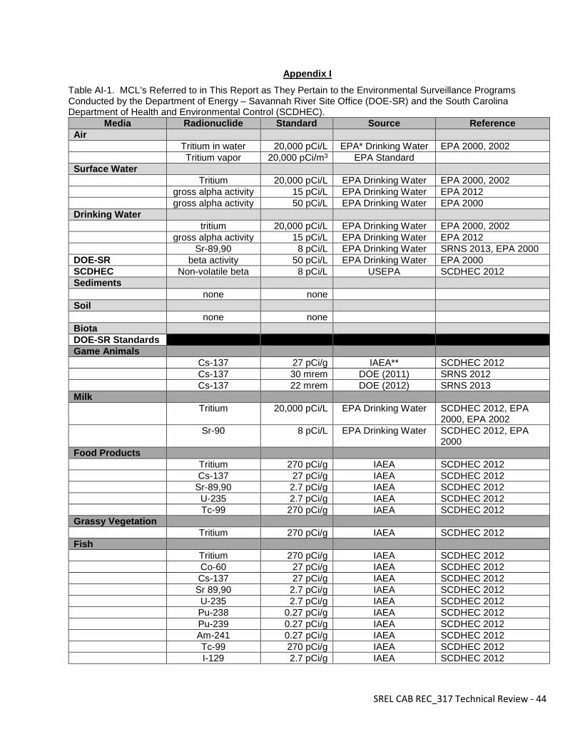
The USEPA has established drinking water standards and health advisories for several radionuclides relevant to the SRS (USEPA 2000 and 2012). Throughout this report we refer to these standards for various types of environmental media (e.g., water and biota). The maximum contaminant level goal (MCLG) is a recommendation from the USEPA that provides a health related benchmark goal for the level at which there are no known or anticipated effects on human health with an adequate margin of safety (USEPA 2012). MCLG’s represent suggested goals and are not legally enforceable. The MCLG for a contaminant is usually quite low and sometimes set to zero because safe levels have not or cannot be determined. For example the MCLG for beta particle activity, gross alpha activity, and uranium are all zero. Thus any detectable radioactive activity from these radionuclides would exceed the MCLG. From an analytical perspective, determination of a true zero concentration is generally beyond what is technologically possible. However as further addressed below, detection limits reported by DOE-SR are well below levels likely to provide an ecological or human risk. Though the MCLG are excellent goals, the presence of detectable radioactive materials is not necessarily an indicator of an ecological or human health risk. The maximum contaminant level (MCL) refers to the highest concentration allowed in drinking water and is legally enforceable by the USEPA in public drinking water (USEPA 2012). MCL’s are set as close to the MCLG as practical taking costs versus benefits into account as well as best available analytical and treatment technologies (USEPA 2012). The danger associated with a particular radionuclide is considered when establishing how high of a contaminant level is allowed by an MCL. For example the MCL for gross alpha particle activity is only 15 pCi/L, whereas this concentration of a low energy, beta-emitting radionuclide such as tritium would be of no concern. The MCL for tritium is actually 20,000 pCi/L. Thus comparing a detected radionuclide level to the radionuclide specific MCL is critical in determining the risk it poses. Please see Appendix I for a list of MCL values used by the DOE-SR and SCDHEC Environmental Surveillance Programs as referred to in this report. Additionally, comparing a detected radionuclide level to a “background” level is essential in assessing the source of detected contamination. As related to the SRS, background contamination refers to contamination present in and around the SRS that does not originate from the SRS. For example, atmospheric deposition from past nuclear testing distributed low levels of Cs-137 worldwide. Consequently an assessment of the impacts of SRS on the local environment must assess whether measures of detectable radionuclides exceed the ambient background concentrations. SRS should indeed strive to achieve the MCLG’s of no contamination, but this will not always be technologically possible. However it is important to be mindful that levels above background do not necessarily indicate an ecological or human risk. For radionuclides that have very low background concentrations, measured levels can be many times above background level and still not present a real risk. For example in 2012, DOE-SR reported 156 pCi/L of tritium in the Savannah River upstream of all tributaries draining the SRS. A concentration of 603 pCi/L was measured below the SRS. Even though this value is nearly 4 times the upstream level, it must be put into perspective that it is still 33 times lower than the 20,000 pCi/L MCL above which would indicate an actual risk. Unlike drinking water, the USEPA has not established MCL’s for solid foods. Various other benchmarks are available and have been used by DOE-SR and SCDHEC. Sometimes, particularly for fish, drinking water criteria have been used. Similar to an MCL, the US Food and Drug Administration has established derived intervention levels (DIL’s) to address safety concerns of various contaminants including some radionuclides. The International Atomic Energy Agency (IAEA) has also established guidelines for MCL’s in food products that present a risk.
SREL CAB REC_317 Technical Review - 9
Throughout the report we will also refer to minimum detection limits (MDL). This is equivalent to a minimum detectable concentration (MDC) as referred to in DOE-SR environmental reports and lower limit of detection (LLD) sometimes used by SCDHEC. In contrast to an MCL, an MDL simply refers to the minimum concentration detectable by the employed methods and analytical instruments. Because of the exceptionally low concentrations of various radionuclides in some media, concentrations below MDL are commonly reported by both DOE-SR and SCDHEC. We did not find this to be of concern in either DOE-SR or SCDHEC results because their reported MDL/MDC values were well below limits thought to be of ecological or human risk concern.
SREL CAB REC_317 Technical Review - 10
Pathways Monitored (by Media Type)
Air & Rainwater Sources and Exposure Pathways to Georgia -- Atmospheric transport is one of the primary pathways for movement of radionuclides released from the SRS to proximate counties in the state of Georgia. Consequently, DOE-SR has monitored and maintained an inventory of airborne radionuclide releases from SRS process facilities since 1952. This surveillance includes alpha, beta, and gamma emitting radionuclides. During the past 20 years, these atmospheric releases have been nearly exclusively tritium, primariy as tritiated water (tritium oxide). The tritiated water becomes incorporated into the natural hydrologic cycle and follows the same transport, deposition, and uptake pathways as water. Atmospheric release of radionuclides can be transported off-site by wind movement (advection). Transport can occur in both the form of particulates and in the gas phase e.g., tritiated water vapor (3H2O). The radionuclides can subsequently be redeposited onto vegetation, soil, and water bodies via rainfall and dry deposition. Analysis of decades of meteological data indicate that winds blow in all directions across the SRS and thus, can potentially transport airborne radionuclides into both South Carolina and Georgia. However, the most frequent wind directions and the highest wind speeds are typically to the southwest, northeast and east. The least frequent wind direction is to the southeast. Monitoring Approaches -- The DOE-SR atmospheric monitoring network includes 15 sampling locations both within and outside of the SRS boundary (Table AM-1). Off-site sampling locations for radionuclides in gas (tritiated water vapor) and airborne particulate matter include 1 site in SC and 3 in GA. Two GA locations are approximately 25 miles from the SRS within the CSRA (Central Savannah River Area) (Richmond and Screven Counties) and the third is a control site in Savannah, GA about 100 miles to the southeast (Savannah location discontinued in 2013). The air monitoring network is designed to include locations within each 45-degree sector around the site. The onsite nework includes 10 stations along the site perimeter and one near the center of the SRS. At the air sampling stations, air particulate matter (collected on filters), gas phase (collected on charcoal canisters) radioiodine (I-129, I-131) and tritium in water vapor (collected on silica gel) are sampled bi-weekly. Wet/dry deposition samples collected on ion column samplers are collected monthly and analyzed for gross alpha, gross beta, strontium, plutonium, americium, uranium, curium, neptunium as well as gamma emitters including Cs-137 and Co-60. Additionally at the 15 atmospheric surveillance stations, DOE-SR collects rain water samples monthly which are analyzed for gross alpha, gross beta, gamma emitting radionuclides, alpha emitting actinides and tritium. Supplimenting these air monitoring stations are additional stations that employ thermoluminescent dosimeters (TLD) to measure total gamma radiation in the ambient air. Most TLD locations are on the SRS and primarily around the site perimeter. However, 12 stations are located offsite (7 in SC and 5 in GA) including the control air monitoring station in Savannah (Savannah location disconinued in 2013).
SREL CAB REC_317 Technical Review - 11
Table AM-1. DOE-SR Air and Rainwater Monitoring Locations On/Off-Site Sampling Station Location
SRS (Center) E-Area, SC Site Perimeter (Northwest) Green Pond, SC Site Perimeter (North) Talatha Gate, SC Site Perimeter (North) East Talatha, SC Site Perimeter (Northeast) Darkhorse, SC Site Perimeter (East) Highway 21/167, SC Site Perimeter (South) Barnwell Gate, SC Site Perimeter (Southeast) Patterson Mill Road, SC Site Perimeter (South) Allendale Gate, SC Site Perimeter (Southwest) D-Area, SC Site Perimeter (West) Jackson, SC 25-miles from SRS (Northwest) Augusta, GA 25-miles from SRS (North) Aiken Airport, SC 25-miles from SRS (South) Highway 301, GA (Control) 100-miles from SRS (Southeast) Savannah, GA (Control – discontinued in 2013)
The SCDHEC air sampling network includes 8 air sampling locations (Table AM-2) that use similar sampling protocols as DOE-SR. Two sample stations are on the site perimeter and three are within 2 miles of it. The two perimeter stations are collocated with DOE-SR stations. Another station is onsite near the E-Area burial ground and two are located within 25 miles of the SRS in Aiken and Allendale. Air particulates are screened for gross alpha and gross beta weekly. Gas phase tritium and rainwater are analyzed monthly. Similar to the DOE-SR surveillance program, SCDHEC maintains 19 TLD montioring locations for ambient gamma emissions that are collected quarterly. Thirteen TLD stations are located on or near the site perimeter, one is near the center of the SRS, and five are offsite within 25 miles of the SRS boundary. A comparison of DOE-SR and SCDHEC sampling frequencies is shown in Table AM-3. Table AM-2. SCDHEC-ESOP Air and Rainwater Monitoring Locations
On/Off-Site Sampling Station Location SRS (Center) E-Area (Burial Ground North), SC Near Site Perimeter New Ellenton, SC Near Site Perimeter Jackson,SC Site Perimeter Allendale Barricade, SRS, SC Near Site Perimeter Snelling, SC Site Perimeter Dark Horse (Williston Barricade), SRS, SC Within 25-miles from SRS Aiken, SC Within 25-miles from SRS Allendale, SC
Table AM-3. Sampling Frequency
Media DOE-SR SCDHEC Air particulates Bi-weekly Weekly Rain water Bi-weekly Monthly Vapor phase Monthly Monthly Ambient gamma irradiance (TLD) Quarterly Quarterly
SREL CAB REC_317 Technical Review - 12
Results Summary – DOE-SR air sampling data indicate that tritium is the only radionuclide routinely detected above the MDL. Tritium was detected in 25% of the 393 tritium vapor samples collected in 2012 which is consistant with observations from the previous 5 years. Average concentrations are highest (172 pCi/m3) near the center of the SRS at the Burial Ground North (BGN) then decreases significantly at the perimeter and off-site locations. Typical concentrations at the center of the SRS were about twice the background level of 3.03 pCi/m3 in Savannah GA 100 miles southeast of the SRS. Using the National Emissions Standards for Hazardous Air Pollutants (NESHAP) protocols the maximum effective dose equivalent was calculated to be less than 0.002% of the 10 mrem/year EPA standard. Tritium was detected in 12% of the rainwater samples, but all were below the 20,000 pCi/L EPA drinking water standard. SCDHEC tritium vapor monitoring at SRS perimeter sites reported values from below MDL to 8.82 pCi/m3 with an average concentration of 4.14 pCi/m3 in 2012. This is somewhat lower than the average 12.1 pCi/m3 measured by DOE-SR. However, all values are greater than three orders of magnitude below the 20,000 pCi/m3 EPA standard. Several factors may contribute to the small differences, less than 2 standard deviations, in average tritium concentrations reported by the DOE-SR and SCDHEC. Since the sampling locations, total number of samples, and sampling frequency at a given location are not identical, it is reasonable to expect minor differences in averaged results. Considering these factors DOE-SR and SCDHEC data are quite comparable. No detectable concentrations of the anthropogenically derived gamma emitting isotopes (Cs-137 or Co-60) were found in the DOE-SR air filter or charcoal canister samples in 2012. The air filters sample partiulate matter and the charcoal canisters gaseous states of radionuclides. Similarly, I-129 or I-131 concentrations in air were all below the MDL. These obsevations are again consistent with results from the previous 5 years. Among the alpha-emitting actinides, only U-234 and U-238 were routinely detected in DOE-SR air filter samples (86% and 93%, respectively). These isotopes are derived from naturally occuring geological media (rocks and minerals) and are commonly detected at low concentrations throughout the region. However, no detectable concentrations of the anthropogenically-derived U-235 were reported for 2012, which is consistant with historical results. Ambient gamma radiation monitoring using TLD’s has been ongoing since 1965. Most of these monitoring locations are currently onsite particularly along the SRS perimeter, but some are located offsite within proximity (<9 miles) of the SRS boundary. DOE-SR results for 2012 indicate gamma exposure rates ranged from 61.6 (NRC_2 location in SC) to 118 mrem/yr (Beech Island, SC). These values are consistent with the results from previous years and are not statistically different than background values comparable locations in the southeastern U.S. The ambient gamma exposure rates in population centers (towns and cities) are slightly higher compared to both rural locations on or near the SRS perimeter and off-site due to the greater use and higher density of certain geological media (containing naturally-derived gamma isotopes) in the building and road materials in these areas. Conclusions and Recommendations -- The DOE-SR air and rainwater radiation environmental monitoring program is overall comprehensive and robust. Tritium is by far the primary radioisotope currently related to the atmosphere from SRS activities. However, an extensive monitoring program demonstrates that tritium concentrations in air and rainwater are far below regulatory concentrations set by EPA for human health protection. However, it is noted that although winds commonly blow across the SRS to the southwest into Georgia, there is no air sampling location in this sector. Sampling of other media (i.e. vegetation) may serve as a proxy for an air monitoring station in this sector as noted below and in the Biota Monitoring section.
SREL CAB REC_317 Technical Review - 13
Discontinuing the Savannah monitoring location in 2013 is not a concern unless in the future, increased contamination is detected at the locations on or around the SRS.
The SCDHEC-ESOP results compare well with the DOE-SR data where approriate direct comparisons can be made. In addition, the concentration ranges and trends are also consistant when all results are compared and support the overall conclusion from all the data that there are no current health risks to biota, including humans, from offsite atmospheric transport of radionuclides. It should be noted that vegetation monitoring discussed in the Biota Monitoring section also supports assessment of atmospheric deposition. The suggested expanded vegetation sampling would ameliorate the wider spaced out air monitoring stations on the southwest side of the SRS. Establishing consistant protocols in processing and statistical analyses would facilitate comparison between the data sets. For example, determinations of detection limits and how non-detects are handled in data analysis should be consistant as possible, recognizing there may be disagreements by experts about how to best address some of these issues.
SREL CAB REC_317 Technical Review - 14
Surface Water
Sources and Exposure Pathways to Georgia -- The DOE-SR and SCDHEC programs monitor surface waters to detect potential contamination of these resources from SRS operations. Contaminants produced from industrial areas on the SRS have entered onsite streams or reservoirs directly from past or present releases or through groundwater outcrops from aquifers contaminated primarily from legacy seepage basins. Onsite stream drainages impacted by SRS operations include Upper Three Runs, Beaver Dam Creek, Fourmile Branch, Pen Branch, Steel Creek, and Lower Three Runs. Contaminants from upstream industrial areas are transported through these streams to the Savannah River either directly or through the Savannah River floodplain swamp. Since most contaminant sources are in upstream locations in these drainages, portions of the contaminants settle out in the tributaries or swamp, but some also reach the Savannah River. People and biota in Georgia may be exposed to contaminants originating from the SRS directly in waters from the Savannah River or wetlands on the Savannah River floodplain that are connected to the Savannah River during base flow levels or during flood events. This is the most likely pathway of exposure. USGS models indicate the potential of groundwater from the SRS discharging on the Savannah River floodplain on the Georgia side of the river (Cherry 2006). This appears to again be a concern on the Savannah River floodplain, not in the uplands of Georgia as addressed in Groundwater Monitoring. Atmospheric deposition represents the potential pathway of SRS contaminants entering Georgia surface waters above the Savannah River floodplain. Risks of atmospheric deposition is also addressed in the Air Monitoring section. Monitoring Approaches -- The extensive DOE-SR radiological surface water monitoring includes analyzing samples from SRS tributary streams, basins, effluents, and the Savannah River. Though the former sample locations are critical for monitoring the potential release of contaminants by SRS operations, we will address in detail the Savannah River because in liquid media, this is the most likely vector of transport directly to Georgia. DOE-SR samples surface water from 5 locations on the Savannah River spanning over a 40 mile reach from above the Upper Three Runs confluence down to Highway 301 (Table SWM-1). Tritium, Co-60, Cs-137, gross alpha, and gross beta are analyzed weekly and other analytes as noted in Table SWM-2 are analyzed annually. Table SWM-1. DOE-SR Savannah River Water Sampling Locations
River Mile Description 118.8 Highway 301 141.5 Below Steel Creek Confluence 150.0 Below Plant Vogtle 150.4 Above Plant Vogtle 160.0 Between Upper Three Runs and SRS border
The SCDHEC program also monitors for radiological contamination from onsite tributaries, stormwater basins, mouths of tributaries at the Savannah River confluence, and the Savannah River. Sampling efforts include 6 locations on the Savannah River that span over a 50 mile length from the Jackson Boat Landing upstream of the SRS, downstream to the Highway 301 crossing (Table SWM-3). The SCDHEC and DOE-SR sampling sites fall within this same geographical range, but compliment rather than entirely duplicate efforts. However, the entire suite of SCDHEC surface water sample locations include 6 locations collocated with DOE-SR collection sites that allow direct comparison of SCDHEC and DOE-SR data. Five of the collocated sites are in onsite tributaries and one is on the Savannah River at Highway 301. All six of the river locations were sampled 3 days a week for tritium. Additionally gross alpha, beta, and a suite of gamma radioisotopes (Table SWM-4) are analyzed in monthly composites from the most upstream and downstream river locations. Five of 6 locations have compositing ISCO samplers that sample every 30 seconds for two 48 hour periods and one 72 hour period each week. Grab samples are collected from River Mile 125 three days per week. The most downstream site is also equipped with a 24 bottle carousel ISCO sampler that collects hourly samples over the same time frame as the composite ISCO sampler. This allows SCDHEC to refine the timing and duration of tritium concentrations when necessary. SCDHEC uses this sampling network to provide downstream drinking water facilities an early warning if pulses of tritium move downriver in their direction. Table SWM-3. SCDHEC-Savannah River Surface Water Sampling Locations
Results Summary -- In 2012, DOE-SR reported tritium concentrations exceeding EPA drinking water standards of 20,000 pCi/L in some streams located on the SRS. Samples from some onsite SRS stream locations also exceeded the EPA 15 pCi/L gross alpha particle activity drinking water standard, but downstream locations prior to exit from the site were reported below this level. Cs-137 was also detected in some stream samples. Critical to assessing exposure to Georgia, tritium concentrations averaged well below the 20,000 pCi/L drinking water standards at all five Savannah River locations. Gross alpha particle activity in the Savannah River also averaged well below the 15 pCi/L drinking water standard. Additionally both gross alpha and beta results in the Savannah River were reported below the EPA screening levels requiring radionuclide specific analyses. Cs-137 was not detected in any of the 250 weekly Savannah River composites in 2012. The SCDHEC also found tritium concentrations to exceed the drinking water standard in some onsite SRS tributaries. The SCDHEC’s sampling locations around the Fourmile Branch confluence with the Savannah River allowed detailed assessment of the dilution of contaminants entering the Savannah River from onsite tributaries. Highest concentrations of contaminants are often found in the Fourmile Branch drainage. Based on measures taken from in and below the mouth of Fourmile Branch, tributary water is rapidly diluted by the Savannah River. The three quarterly water samples collected from the mouth of Fourmile Branch in 2011 averaged over 39,000 pCi/L. This is well above the EPA 20,000 pCi/L drinking water standard. However, only 30 feet below the confluence, the concentration was diluted to 7,388 pCi/L and averaged below detection levels 150 feet below the Fourmile Branch confluence. Accordingly average and even maximum recorded tritium concentrations from all five Savannah River locations were well below the drinking water standard. Additionally all Savannah River location samples were below detection limits of analyzed gamma emitters. Gross alpha averages were below the 15 pCi/L drinking water standards and all average gross beta levels were below the 50 pCi/L MCL that requires additional screening.
Care must be taken when comparing DOE-SR and SCDHEC averages because of the differences in their presentation of measures below the detection limits. SCDHEC averages only measures above detections limit. Though this generally provides a conservatively high measure, it can lead to seemingly large differences if there are few detects and one detect happens to be larger than the other samples. DOE-SR averages all measurements, even those that are below detection limits or even negative. This will tend to lower averages relative to the SCDHEC method. However since detection limits are far below levels of concern this does not appear to affect assessment of ecologically relevant contaminant levels. DOE-SR and SCDHEC reported similar patterns of contaminant concentrations at all collocated collection sites. For example, tritium levels at collocated sites were within one standard deviation (SD) at all sites but one and it was within 2 SD. DOE-SR average gross beta was within one SD of SCDHEC at the Savannah River 301 bridge site. DOE-SR detected Cs-137 from a single site (15 pCi/L) and Am-241 from a single site. SCDHEC did not detect gamma emitters at any sites. Conclusions and Recommendations -- The Savannah River main channel is adequately sampled by the combined efforts of DOE-SR and SCDHEC and these efforts should continue. Additional sampling in Georgia Savannah River floodplain wetlands is not necessary unless substantial contaminants are found in the recommended sediment samples described in
SREL CAB REC_317 Technical Review - 17
Sediment Monitoring. Additional sampling of Georgia surface waters above the Savannah River floodplain are not presently necessary unless the Air Monitoring program indicates increased atmospheric deposition. If significant increases in atmospheric deposition are ever recorded in the future along the site perimeter, then sampling Georgia surface waters above the Savannah River may be warranted. Sampling sediment in additional Savannah River Floodplain wetlands coupled with the ongoing Groundwater Monitoring program adequately assesses risks of contaminated groundwater entering Georgia surface waters.
SREL CAB REC_317 Technical Review - 18
Drinking Water
Sources and Exposure Pathways to Georgia -- The DOE-SR and SCDHEC ESOP programs monitor drinking water sources to detect potential contamination of these resources from SRS operations. Sources for contaminants transported in liquid media related to risks of drinking water contamination are similar to those discussed for surface waters. Contaminants produced from industrial areas on the SRS have entered onsite streams or reservoirs directly from past or present releases or through groundwater outcrops from aquifers contaminated primarily from legacy seepage basins. In particular, SRS contaminants transported through SRS tributaries to the Savannah River represent a risk to downstream drinking water systems that draw water directly from the Savannah River. Additionally atmospheric deposition and subsequent runoff into surface waters that feed surface water fed drinking water facilities represent a potential pathway of SRS contaminants entering Georgia drinking water. This risk is addressed in detail in the Air Monitoring section. Atmospheric deposition followed by percolation represents a potential risk to shallow groundwater fed public systems or private wells. This risk is further addressed in the Air Monitoring and Groundwater Monitoring sections. Monitoring Approaches -- The DOE-SR monitors’ drinking water sources from 13 locations on the SRS and 4 offsite water treatment facilities that draw water from the Savannah River. Onsite monitoring includes 2 large water treatment plants and 11 smaller sources including various buildings or wells. Offsite monitoring includes 3 large municipal systems downstream of the SRS and one upstream (Table DWM-1). Monthly samples and biweekly ISCO samples of Raw Water (pretreated) from the 4 offsite facilities are analyzed. Monthly samples are also analyzed on treated water from the 4 offsite facilities. Sampling schedules at the two large onsite treatment plants included 5 samples on 4 dates in 2012 (2 samples in January and 1 in each June, July and October). Other onsite locations are sampled annually. Tritium, Co-60, and Cs-137, gross alpha, and gross beta are analyzed from offsite samples (Table DWM-2). In 2013, monitoring was discontinued at 2 of the 4 offsite drinking water facilities, Beaufort-Jasper Water and Sewer Authority – Purrysburg and the City of Savannah Industrial and Domestic Water Supply Plant. In addition, raw water sampling was discontinued (finished water only) at all drinking water monitoring facilities. The SCDHEC monitoring program includes collocated sites with DOE-SR, but also greatly increases the offsite scope of drinking water monitoring. SCDHEC samples 19 groundwater fed and 4 surface water fed public drinking water systems located in South Carolina within 30 miles of the center of the SRS. Most sites are concentrated to the north or west of the SRS as are most municipal population centers. Only the Allendale sample is taken from the largely rural southwest. However, it should be noted the SCDHEC Groundwater Monitoring program monitors additional wells for radionuclide contamination around the entire perimeter of the site. This is further addressed in Groundwater Monitoring. Collocation of SCDHEC sites at the four DOE-SR offsite collection sites allowing direct comparisons of SCDHEC and DOE-SR data. In 2011, tritium, gross alpha, and non-volatile beta data were compared between SCDHEC and DOE-SR. SCDHEC routinely monitors for tritium, gross alpha, non-volatile beta, and a suite of gamma emitting radionuclides (Table DWM-3) in drinking water samples.
SREL CAB REC_317 Technical Review - 19
Table DWM-1. DOE-SR Drinking Water Sampling Locations Offsite Municipal Water Sources Location Sample Type North Augusta Water Treatment Plant Above SRS, SC Composite Beaufort-Jasper Water and Sewer Authority’s
Chelsea Water Treatment Plant Below SRS, SC Composite
Beaufort-Jasper Water and Sewer Authority’s Purrysburg Water Treatment Plant
Below SRS, SC Composite1
City of Savannah Industrial and Drinking Water Supply Plant
Below SRS, GA Composite1
Onsite Location Sample Type Large treatment plants (N=2) SRS, SC Grab Other Sources (N=11) SRS, SC Grab
1 – discontinued in 2013 Table DWM-2. DOE-SR Drinking Water Analytes Analyte
Results Summary -- No DOE-SR collected samples exceeded the EPA’s drinking water maximum contaminant level (MCL) of 20,000 pCi/L tritium, 15 pCi/L for gross alpha activity, 50 pCi/L beta activity, or the 8 pCi/L for Sr-89, 90. Co-60, Cs-137, Sr-89, 90, U-235, Pu-238, Pu-239, Am-241, and Cm-244 were not detectable in any drinking water samples. Uranium-234 was
SREL CAB REC_317 Technical Review - 20
detectable in eight onsite samples and uranium-238 in seven, but all analytical results were below the EPA MCL for alpha emitting radionuclides. Similarly SCDHEC found that no collected samples from either groundwater fed or surface water fed drinking water systems exceeded the EPA’s drinking water maximum concentration limits of 20,000 pCi/L tritium. In fact, of the samples exceeding the minimum detection limit, both ground and surface water systems averaged under 460 pCi/L and only one groundwater system even reached the detection limit. Likewise gross alpha did not exceed the 15 pCi/L MCL and non-volatile beta did not exceed 8 pCi/L. No gamma emitting nuclides of concern occurred at concentrations above detection limits. Thus concentrations do not represent known health risks for humans. DOE-SR and SCDHEC data show similar patterns at the collocated sample sites. Though some variability occurred all values by both programs were well below the EPA drinking water limits values for gross alpha, non-volatile beta, and tritium, and neither detected gamma emitting radionuclides Conclusions and Recommendations -- Current monitoring provides no evidence of significant effects of SRS operations on drinking water supplies. It should be noted however that drinking water monitoring is further supported by DOE-SR and SCDHEC Groundwater, Surface Water and Air Monitoring programs. SCDHEC offsite drinking water sampling locations tend to be concentrated to the north and west of the SRS. As of 2013, DOE-SR samples no public drinking water systems in Georgia. However groundwater is monitored in a 30 mile radius around the site by SCDHEC as are wells along the site periphery and across the river in Georgia by DOE-SR. These efforts described in more detail in Groundwater Monitoring fill potential gaps and provide monitoring relevant to both groundwater fed municipal systems as well as private wells in Georgia. Similar to surface water as described above, surface fed drinking water systems above the Savannah River monitoring will not require additional monitoring unless Air Monitoring indicates increased atmospheric deposition as described in detail in the Air Monitoring section. The 2013 discontinuation of monitoring raw water samples and site reductions do not represent a risk unless future surface water monitoring detects increased levels of contaminants in the Savannah River at Highway 301 by DOE-SR or SCDHEC-ESOP. Current drinking water, surface water, and ground water monitoring programs should be continued by DOE-SR and SCDHEC to continue monitoring for potential risks
SREL CAB REC_317 Technical Review - 21
Ground Water
Sources and Exposure Pathways to Georgia -- Both DOE-SR and SCDHEC monitor for the potential of groundwater contaminated by SRS operations migrating offsite. SRS operations have contaminated the groundwater beneath and adjacent to some SRS industrial areas. A majority of the groundwater contamination involving radionuclides is located near the center of the site. One exception is tritium in aquifers below and around D area. Outcropping of contaminated aquifers into and transport through SRS surface water tributaries presently represents the greatest risk of Georgia being exposed to water from SRS contaminated aquifers. Stream transport is addressed in Surface Water Monitoring. Above the Savannah River floodplain, atmospheric deposition of contaminants followed by their percolation into shallow aquifers is also a potential transport route of SRS originating contaminants entering Georgia groundwater and is further addressed in Air Monitoring.
Trans-river migration refers to the movement of groundwater beneath a river from one side of the river to the other. The possibility of trans-river migration of groundwater under the Savannah River has been extensively investigated (Clarke and West 1997, Cherry 2006, WSRC 2006). Aquifers beneath the SRS discharge heavily into the Savannah River, its floodplain and tributary valleys (Clarke and West 1997). The geologic history of the Savannah River valley results in interception of substantially more groundwater than would occur from only the present day Savannah River floodplain. On a geologic time scale, the Savannah River valley was previously more deeply incised followed by a partial backfilling with alluvial sediments (WSRC 1995, Clarke and West 1997). The valley incision was sufficiently deep to cut through the underlying aquifers. Backfilling with permeable alluvial sediments has provided a direct hydrologic connection between these aquifers and the Savannah River valley (Clarke and West 1997). This results in strong discharge of groundwater into portions of the Savannah River valley from aquifers considerably deeper than the modern floodplain (Clarke and West 1997). The likelihood of trans-river groundwater migration is consequently reduced.
USGS models have indicated potential trans-river movement of groundwater from the SRS to the Georgia side of the river, but discharge would be restricted to the Savannah River floodplain (Clarke and West 1997, Cherry 2006). Specifically, discharge was predicted in a marshy area near Flowery Gap Landing on the Georgia side of the Savannah River floodplain. The Flowery Gap marsh was also indicated to be a discharge point for groundwater from Georgia, thus water is thought to enter the wetland from both directions. Thus under current hydrological conditions, movement of contaminants from South Carolina would have to go against the prevailing gradient to migrate deeper into Georgia. As typical of water discharged on the floodplain, groundwater discharged in this floodplain wetland likely flows to the river (Clarke and West 1997). Hydrologic models do not indicate groundwater from the SRS moving past the Savannah River floodplain. The slow movement of groundwater that is generally measured in 10’s, 100’s, or even 1000’s of years depending upon depth must also be taken into account. This is particularly important for radionuclides with short half-lives. Even if groundwater contaminated with tritium migrated off-site, the tritium would likely decay before reaching the Savannah River (WSRC 2006). Monitoring Approaches -- DOE-SR groundwater monitoring includes both waste-site monitoring in areas of known contamination as well as surveillance especially along site boundaries near population centers such as Jackson, SC. Monitoring groundwater in and around known waste sites provides critical data on what contaminants are of concern as well as allows tracking of their movement. The surveillance around the site periphery monitors potential movement of contaminants offsite. Approximately 2,000 wells and numerous direct-push holes are sampled per year for radiological monitoring. The latter technology, acquires shallow groundwater samples
SREL CAB REC_317 Technical Review - 22
by pressing, driving or vibrating a small diameter pipe into the ground. Permanent well depths can exceed 1,000 feet, but most are shallower where contamination is more likely. Most wells are sampled semiannually, but some are sampled monthly, quarterly, or annually. Factors influencing frequency include considerations such as groundwater velocity, distance to contaminant source or operating remedy, regularity of contaminant concentrations, and regulatory requirements. Sampling at a regional scale provides a better understanding of groundwater movement patterns. The 2012 SRS report stated that sampling and shipping is consistent with US EPA, SCDHEC, and US Dept. of Transportation guidelines. Assessed radiological constituents are variable, but can include gross alpha and non-volatile beta indicators, gamma emitters, iodine-129, strontium-90, radium isotopes, uranium isotopes, and other alpha and beta emitters.
Of critical importance to Georgia, DOE-SR also monitors 44 wells distributed in Burke and Screven counties of Georgia. Thirty-nine of these wells were sampled in 2012. Of the un-sampled 2012 wells, four were dry and one had a damaged well casing. SCDHEC conducts further surveillance to determine whether contaminated groundwater originating from SRS operations is migrating off of the SRS. SCDHEC uses a network of 75 wells that include; wells consisting of cluster wells owned and maintained by SCDNR as well as private wells and public water systems. Cluster wells are distributed along the SRS periphery. The monitored area includes wells distributed within a 10 mile perimeter beyond the SRS boundary, along with random SRS perimeter wells, and background sites located across SC. Subsets of the network are sampled annually. Depths range from the shallow surficial aquifers to wells over 1,100 feet deep. In 2011, 11 of their network wells and 3 background wells were sampled. Tritium, gross alpha, non-volatile beta, and a suite of gamma emitting radionuclides were analyzed (Table GWM-1). ESOP and DOE-SR did not collocate sampling so direct comparison of their data was not possible. Table GWM-1. SCDHEC ESOP Drinking Water Analytes.
Results Summary -- To date, DOE-SR has found no offsite wells to have been contaminated by SRS contaminants migrating through groundwater. Similarly no drinking water level exceedances occurred in wells near the site border between A/M area and Jackson. The relatively long distances between radionuclide contaminated aquifer plumes that are primarily located in the center of the SRS and the site boundaries combined with the generally slow movement of groundwater reduce the risk of migration of contaminated groundwater offsite. Tritium was below detection limits in 37 of the 39 Georgia samples taken in 2012; the two detects were 721 and 587 pCi/L which are well below the 20,000 pCi/L EPA drinking water standard. Since 1999, tritium in the Georgia wells has remained below 1,500 pCi/L with the average concentration under 500 pCi/L during this time. Again these concentrations are well below the EPA 20,000 pCi/L drinking water standard. Maps of aquifer radionuclide contaminant plumes indicate that most plumes except D Area are far from the site boundary. Potential contaminants emerging in outcrops from
SREL CAB REC_317 Technical Review - 23
D Area should be detected in the Savannah River in Surface Water Monitoring before reaching Georgia. In 2011 SCDHEC analyses, alpha activity was only detected from two of the 14 wells and neither exceeded the 15 pCi/L EPA drinking water maximum contaminant level (MCL). Beta activity was detected at one well, but did not exceed the 8 pCi/L MCL; tritium was not detected from the 11 network wells, but activity was recorded at one background well, however the level was only 767 pCi/L which is well below the 20,000 pCi/L MCL. The 2.57 pCi/L beta activity detected at one well, could be due to decay of natural occurring uranium. Non-volatile beta activity due to naturally occurring uranium is well documented in SC. Concentrations of all gamma activity were below the detection limits in all samples.
A direct comparison of DOE-SR and ESOP data is not possible because they do not have collocated sites, but neither group reported contamination of offsite wells by SRS operations. Conclusions and Recommendations -- DOE-SR reports contamination of sufficient concentration to be of concern in aquifers on the interior of the SRS, in and around industrial areas. However neither DOE-SR nor SCDHEC found evidence of contaminants migrating to offsite wells. DOE-SR and SCDHEC should continue these monitoring programs. DOE-SR should also continue monitoring the Georgia wells to maintain confirmation that significant contaminants are not entering Georgia aquifers from the SRS. Each year a subset of wells sampled by SCDHEC and DOE-SR should be collocated and sampled at the same time to allow direct comparison of their data. This would provide Georgia and SC residents an independent verification of DOE-SR well data. In 2011, SCDHEC reported that such collocation of sampling may occur in the future at perimeter wells. Risk of trans-river migration of groundwater to portions of Georgia past the Savannah River floodplain seems very low under current conditions. Should high volume pumping begin adjacent to the floodplain in the area of the Flowery Gap Landing marsh then this subject may need to be further addressed. Similarly if high volume pumping occurred adjacent to the flood plain in the area downstream of the SRS where the river is less influential to aquifers because of their greater depth, then again the subject may warrant further attention. However the greater distance from the SRS of the second scenario greatly reduces risk of contamination even if the trans-river migration of groundwater occurred. The spatial extent of DOE-SR 2012 sampling is difficult to assess without a map indicating the location of all sampled wells. Future DOE-SR reports should provide a map illustrating locations of all sampled wells, especially those along the site periphery. We realize that with so many wells, it will not be possible to label each well, but the map could indicate the geographic distribution of the sampled wells. UTM coordinates of wells are included in the supporting data provided with the Annual DOE-SR Environmental Report, but viewing sampled locations from such data requires GIS software that the general public will not often have. Additionally the geographic projection of the UTM coordinates is not included with the groundwater data file, although it may be elsewhere in the report or supporting data. A map would make this information readily available to the general public. Similarly the public, including residents of Georgia, would benefit from the DOE-SR report presenting data specifically from wells along the entire SRS periphery. Based on SCDHEC results we do not expect to find contaminant concentrations of concern, but these data should be better presented.
SREL CAB REC_317 Technical Review - 24
Sediments
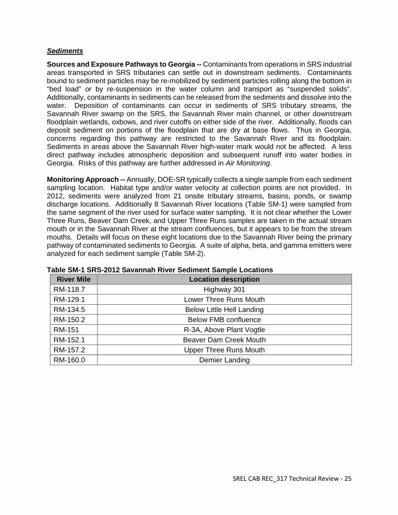
Sources and Exposure Pathways to Georgia -- Contaminants from operations in SRS industrial areas transported in SRS tributaries can settle out in downstream sediments. Contaminants bound to sediment particles may be re-mobilized by sediment particles rolling along the bottom in “bed load” or by re-suspension in the water column and transport as “suspended solids”. Additionally, contaminants in sediments can be released from the sediments and dissolve into the water. Deposition of contaminants can occur in sediments of SRS tributary streams, the Savannah River swamp on the SRS, the Savannah River main channel, or other downstream floodplain wetlands, oxbows, and river cutoffs on either side of the river. Additionally, floods can deposit sediment on portions of the floodplain that are dry at base flows. Thus in Georgia, concerns regarding this pathway are restricted to the Savannah River and its floodplain. Sediments in areas above the Savannah River high-water mark would not be affected. A less direct pathway includes atmospheric deposition and subsequent runoff into water bodies in Georgia. Risks of this pathway are further addressed in Air Monitoring. Monitoring Approach -- Annually, DOE-SR typically collects a single sample from each sediment sampling location. Habitat type and/or water velocity at collection points are not provided. In 2012, sediments were analyzed from 21 onsite tributary streams, basins, ponds, or swamp discharge locations. Additionally 8 Savannah River locations (Table SM-1) were sampled from the same segment of the river used for surface water sampling. It is not clear whether the Lower Three Runs, Beaver Dam Creek, and Upper Three Runs samples are taken in the actual stream mouth or in the Savannah River at the stream confluences, but it appears to be from the stream mouths. Details will focus on these eight locations due to the Savannah River being the primary pathway of contaminated sediments to Georgia. A suite of alpha, beta, and gamma emitters were analyzed for each sediment sample (Table SM-2). Table SM-1 SRS-2012 Savannah River Sediment Sample Locations
River Mile Location description RM-118.7 Highway 301 RM-129.1 Lower Three Runs Mouth RM-134.5 Below Little Hell Landing RM-150.2 Below FMB confluence RM-151 R-3A, Above Plant Vogtle RM-152.1 Beaver Dam Creek Mouth RM-157.2 Upper Three Runs Mouth RM-160.0 Demier Landing
SREL CAB REC_317 Technical Review - 25
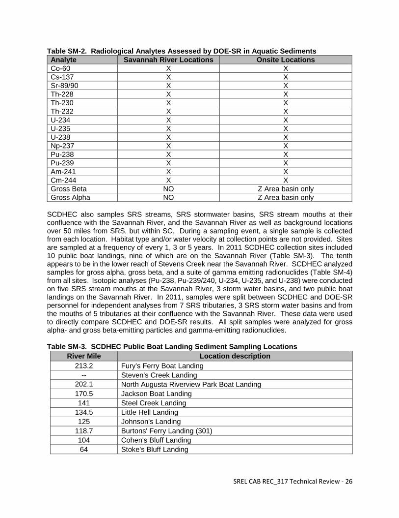
Table SM-2. Radiological Analytes Assessed by DOE-SR in Aquatic Sediments Analyte Savannah River Locations Onsite Locations Co-60 X X Cs-137 X X Sr-89/90 X X Th-228 X X Th-230 X X Th-232 X X U-234 X X U-235 X X U-238 X X Np-237 X X Pu-238 X X Pu-239 X X Am-241 X X Cm-244 X X Gross Beta NO Z Area basin only Gross Alpha NO Z Area basin only
SCDHEC also samples SRS streams, SRS stormwater basins, SRS stream mouths at their confluence with the Savannah River, and the Savannah River as well as background locations over 50 miles from SRS, but within SC. During a sampling event, a single sample is collected from each location. Habitat type and/or water velocity at collection points are not provided. Sites are sampled at a frequency of every 1, 3 or 5 years. In 2011 SCDHEC collection sites included 10 public boat landings, nine of which are on the Savannah River (Table SM-3). The tenth appears to be in the lower reach of Stevens Creek near the Savannah River. SCDHEC analyzed samples for gross alpha, gross beta, and a suite of gamma emitting radionuclides (Table SM-4) from all sites. Isotopic analyses (Pu-238, Pu-239/240, U-234, U-235, and U-238) were conducted on five SRS stream mouths at the Savannah River, 3 storm water basins, and two public boat landings on the Savannah River. In 2011, samples were split between SCDHEC and DOE-SR personnel for independent analyses from 7 SRS tributaries, 3 SRS storm water basins and from the mouths of 5 tributaries at their confluence with the Savannah River. These data were used to directly compare SCDHEC and DOE-SR results. All split samples were analyzed for gross alpha- and gross beta-emitting particles and gamma-emitting radionuclides. Table SM-3. SCDHEC Public Boat Landing Sediment Sampling Locations
River Mile Location description 213.2 Fury's Ferry Boat Landing
-- Steven's Creek Landing 202.1 North Augusta Riverview Park Boat Landing 170.5 Jackson Boat Landing 141 Steel Creek Landing
* See text for list of sites. Results Summary -- Generally radionuclide concentrations are higher in SRS tributary or swamp sediments than off site in the Savannah River as large portions of contaminants settle out closer to the sources. Cs-137 was the only man-made gamma emitter detected by DOE-SR in the Savannah River sediments. The highest concentration in river sediment was only 0.605 pCi/g and at RM 150.2. In 2012, Cs-137 and Sr-89/90, concentrations were less than 1 pCi/g at all Savannah River locations. Pu-238 and Pu-239 were detected from onsite sediments, but at no offsite locations. SCDHEC found Cs-137 concentrations highest at stream locations on the interior of the SRS, intermediate in sediments from the mouths of SRS tributaries at their confluence with the SRS, and lowest in the Savannah River. Cs-137 averaged only 0.16 pCi/g in sediments at public boat landings on the Savannah River and ranged from 0.05 to 0.31 pCi/g. Gross alpha activity was detected at three of the five SRS stream mouths at the Savannah River with detected activity at the creek mouths averaging 17.5 (9.7 to 30.4) pCi/g. However, gross alpha activity was not detected in sediments at any of the Savannah River boat landings. Gross non-volatile beta detections averaged 23.0 (16.5-36.8) pCi/g from the tributary mouths and beta activity was detected at 9 of 10 public boat landings with detections averaging 19.77 (9.28-35.3) pCi/g. Both DOE-SR and SCDHEC reported generally higher concentrations of contaminants in sediments from onsite streams than from the Savannah River. SCDHEC reported an average of 0.97 (±1.5) pCi/g Cs-137 from on-site streams whereas DOE-SR reported 10.2 (±20.2) pCi/g with R Canal included and 6.6 (±14.6) pCi/g with R Canal excluded. In publically accessible Savannah River and SRS creek mouths, both organizations found an average of < 1 pCi/g Cs-137. Conclusions and Recommendations -- Sampling locations in the Savannah River proper are adequate, but additional sites should be included in floodplain wetlands or river cutoffs that extend into Georgia. These habitats represent potential depositional zones for contaminants transported by the river. Furthermore sediment sampling at each location is presently inadequate. Sampling sediments in lotic or lentic systems is critical because a large portion of contaminants in an aquatic system can be stored in the sediments (Sayre et al. 1963, EPA 2001). Contaminant concentrations in water can be quite low in the water column, but be accumulating to considerable levels in sediments (Sayre et al. 1963). Assessing contaminants in sediments of flowing water systems presents a particular challenge. Bottom sediments are constantly moving and
SREL CAB REC_317 Technical Review - 27
contaminants are not evenly distributed on the stream bottom. Course sands in swift currents typically have lower contaminant concentrations whereas fine sediments are often richer in the organic matter typically found in slower “depositional zones” and can have higher contaminant concentrations (Nelson and Haushild 1970, Shelton and Capel 1994, Paul and Meyer 2001). Accordingly sample site selection is critical. Since diverse organisms inhabit depositional zones where the highest concentrations of contaminants accumulate, contaminants stored in sediments can also enter aquatic food webs. In fact, recent work on the SRS has indicated taxa inhabiting these depositional zones to be accumulating higher levels of contaminants than those inhabiting coarse sand. Because of the heterogeneity of contaminants in stream bottoms, multiple samples per study reach are required to adequately characterize contaminants stored in stream sediments. Collection from depositional zones would provide an assessment of maximum concentrations found in the sediments. The USGS (Shelton and Capel 1994) recommends collecting samples from 5-10 depositional zones per study reach. Ideally, each sample is composed of composited subsamples from each depositional zone (Shelton and Capel 1994, USEPA 2001). Numbers of subsamples depend upon the size of the depositional zone.
SREL CAB REC_317 Technical Review - 28
Soils
Sources and Exposure Pathways to Georgia -- When discussing the concentration of radionuclides in soils, it is important to note that radionuclides may have accumulated over decades and detected levels are not likely indicative of annual deposition. The airborne release of actinides and fission products that may potentially contaminate soils can be largely restricted to M Area, the reactor areas and the General Separations Area. To evaluate such contamination, DOE-SR collects soil samples on an annual basis at 21 locations as part of the SRS radiological monitoring efforts. DOE-SR collects three offsite soil samples within the state of Georgia (reduced to 2 in 2013), compared to one offsite soil sample collected annually in the state of South Carolina, and twelve samples that are collected at the site perimeter. DOE-SR soil samples are generally collected in the vicinity of the air monitoring stations. Two of the GA sampling locations, the New Savannah River Bluff Lock and Dam and the Highway 301 Savannah River crossing locations, are approximately 25 miles from the SRS, while the third GA location in Savannah, GA is approximately 100 miles from site (Savannah location discontinued in 2013). The SC sampling location in Aiken is approximately 25 miles from the SRS. Soils from five additional SRS onsite locations (i.e., F Area, H Area, Z Area and two locations at the Burial Ground) are provided as an additional indicator of atmospheric deposition at locations in close proximity to site activities that may result in atmospheric releases for comparison with perimeter and offsite samples. SCDHEC also has an independent soil monitoring program. In 2011, the most recent year for which the annual report is available online, SCDHEC collected 19 soil samples (0-12” depth) near the SRS perimeter, 10 samples along the Savannah River at public boat landings, and 6 random background samples from locations greater than 50 miles from the SRS. Sampling at locations greater than 50 miles from the SRS was initiated by SCDHEC in 2004 in an effort to better define background concentrations throughout the state. Monitoring Approach -- Once collected, the DOE-SR soil samples are analyzed for a limited set of gamma emitters (i.e., Co-60 and Cs-137), Sr-89 & 90, and actinides (i.e., Th-228, Th-230, Th-232, U-234, U-235, Np-237, U-238, Pu-238, Pu-239, Am-241, and Cm-244). In contrast, SCDHEC monitors a much broader range of gamma emitters than the DOE-SR, plus gross alpha and non-volatile gross beta as a screening survey for actinides and fission products (e.g., Sr-89, Sr-90) (Table S-1). Table S-1. SCDHEC ESOP Soil Analytes.
Results Summary -- Differences in the analytical protocols used by DOE-SR and SCDHEC make it difficult to directly compare much of the soil monitoring data. However, consistent with DOE-SR radiological monitoring efforts for 2011 and 2012, Cs-137 was detectable in most of the soil samples collected in 2011 by SCDHEC. The average Cs-137 levels for SRS perimeter soil samples reported by DOE-SR for 2011 (0.16 pCi/g) and 2012 (0.22 pCi/g) are somewhat greater than the SCDHEC perimeter soil values for 2011 (0.11 pCi/g), but within two standard deviations of the sample averages. This suggests that any differences between the three data sets are not statistically significant. In addition, Cs-137 is widely distributed in the environment due to general
SREL CAB REC_317 Technical Review - 29
atmospheric fallout associated with nuclear weapons testing. In fact the average Cs-137 concentration in the background soils collected by SCDHEC from outside the 50 mile radius of the SRS in 2011 was higher than the soil samples collected at the SRS perimeter. The limited number of detections reported for Co-60 and Am-241, the other two gamma emitting radionuclides that were evaluated by both DOE-SR and SCDHEC, make it difficult to compare the two data sets. SCDHEC reported no elevated gross alpha levels for soil samples above the detection limit (≈10.2-14.7 pCi/g for perimeter soils), which is somewhat higher than the gross alpha detection limit for soils reported by DOE-SR (1.66 pCi/g). Furthermore, DOE-SR reports much lower soil detection limits for individual actinides, the combined source for much of the gross alpha activity. SCDHEC reported gross beta detections in seven of the 19 SRS perimeter samples, and seven of the ten riverbank landing samples for 2011. SCDHEC reported no gross beta detections in the background soils for 2011. However, similar to gross alpha analysis, DOE-SR also reports a lower detection limit for gross beta analysis as well, 2.75 pCi/g, compared to ≈ 8.50 to 11.5 pCi/g. DOE-SR detected various uranium isotopes at several soil sampling locations; however, uranium is naturally occurring in soils and the reported values are not indicative of significant accumulation. Conclusions and Recommendations – Current soil monitoring efforts at the site perimeter and off-site within GA and SC are generally adequate for evaluating atmospheric deposition and accumulation of radionuclides derived from the SRS. Soil samples collected by SCDHEC within the Savannah River floodplain may be subject to additional pathways for radionuclide transport, i.e., either in dissolved form or associated with suspended sediments transported from the SRS. This can result in greater variation when compared to upland sites. Given current site release rates, additional floodplain sampling is unlikely to identify public exposure risks that are not addressed by current sampling efforts or recommendations provided in the Sediments section. In general, the levels of radionuclides in SRS perimeter soils reported for both DOE-SR and SCDHEC monitoring efforts are quite low, much of which can be attributed to global fallout or natural background levels of uranium. However, to better facilitate comparison of the two data sets in the future, DOE-SR may want to include initial gross alpha/beta screening results along with the currently reported actinide and strontium results in the annual SRS environmental report. While additional actinide analysis may not be warranted, SCDHEC should review current analytical protocols to determine if the gross alpha/beta detection limits can be practically lowered to a level that is more consistent with DOE-SR detection limits. While potentially providing information about background radiation levels, collecting additional soil samples in Georgia for radiological analysis would be of limited value in estimating public exposure dose.
SREL CAB REC_317 Technical Review - 30
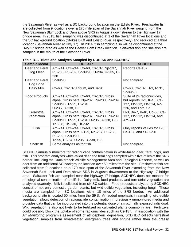
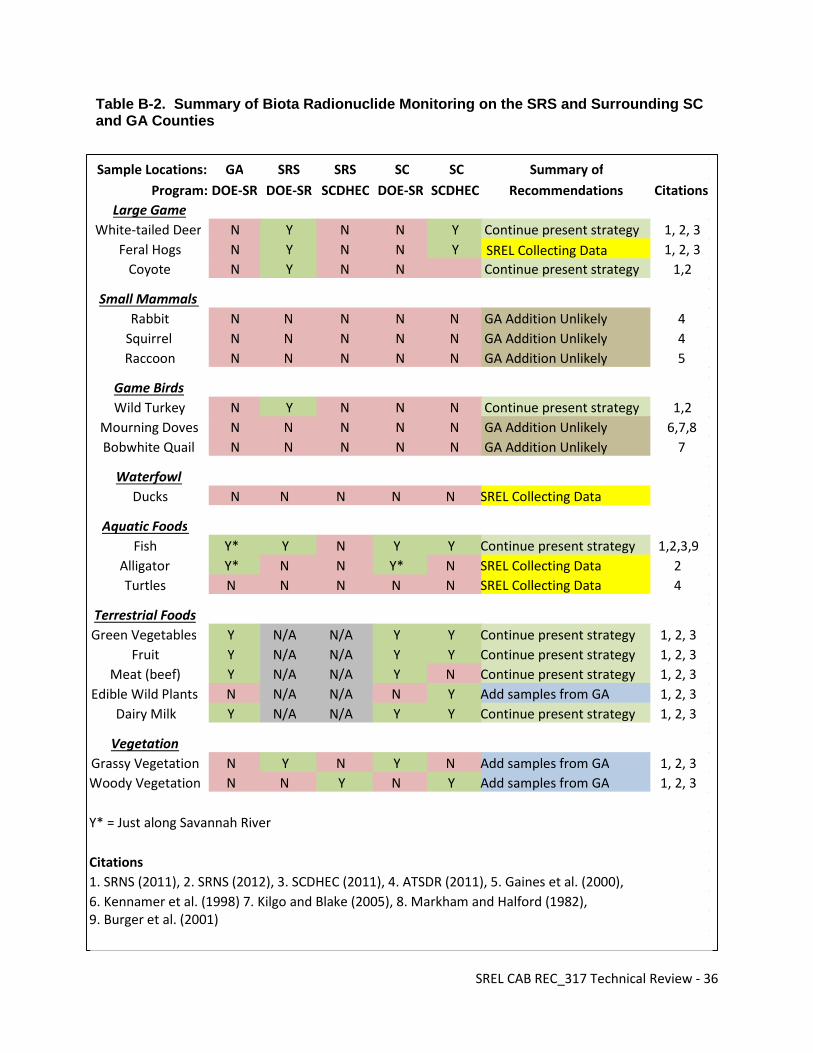
Biota
Sources and Exposure Pathways to Georgia –Both DOE-SR and SCDHEC monitor terrestrial and aquatic biota for potential contamination from SRS operations. Radionuclides produced by past and present operations have been released into the air as well as into SRS streams and reservoirs. For example, Cs-137, a man-made fission product, has been released into the environment from several SRS industrial areas. However, all detected Cs-137 cannot be assumed to be of SRS origin since past nuclear testing has distributed Cs-137 worldwide. Tritium occurs naturally at low concentrations due to cosmic radiation, but is also a nuclear material produced on the SRS that has been released directly as part of operations or entered site streams through groundwater outcrops from shallow aquifers contaminated by seepage basins. Consequently potential pathways of contaminants to biota in Georgia can be via air or water. People of Georgia may be exposed to biota that accumulate contaminants while on the SRS and then migrate to Georgia. Alternatively SRS contaminants may be transported by air or water to Georgia and then subsequently accumulated by Georgia resident biota. Atmospheric deposition of contaminants directly on biota or on the food resources of game and farm animals represents the most potentially widespread pathway of exposure. Airborne contaminants may impact game animals including white-tailed deer, feral hogs, raccoons, squirrels, rabbits, coyotes, waterfowl and game birds as well as dairy milk, food products (green vegetables, fruit, and meat), and vegetation. Direct exposure of biota to contaminants transported through SRS streams will be restricted to the Savannah River and its floodplain. Aquatic organisms such as fish, shellfish, alligators, and turtles may be impacted as well as any terrestrial animals that drink Savannah River water or come in contact with potentially contaminated sediments. Atmospheric deposition of contaminants into Georgia surface waters and subsequent exposure of biota also represents an additional potential exposure pathway. Monitoring Approaches -- DOE-SR monitors a diverse array of wild and domestic plants and animals. Monitoring includes game animals such as white-tailed deer, feral hogs, coyotes, and wild turkeys. Additionally, fish and shellfish in the Savannah River are monitored as well as dairy milk, food products (green vegetables, fruit, and meat), and vegetation. Sample locations vary by media, but include extensive onsite sampling, locations along the SRS perimeter, the Savannah River, and various offsite locations in both South Carolina (SC) and Georgia (GA). Radionuclides analyzed vary by media (Table B-1). DOE-SR analyzes all white-tailed deer, feral hogs, coyotes and wild turkeys hunted annually onsite during SRS sponsored hunts for radiological contaminants. In 2012, 543 deer, 100 feral hogs, 38 coyotes and 28 turkeys were harvested, determined to be safe, and released for consumption during the SRS hunts. There are no radiological checks conducted by DOE-SR on the adjoining Crackerneck Wildlife Management Area and Ecological Reserve which is operated through a SCDNR/ DOE-SR cooperative agreement. Dairy milk was collected quarterly from 4 SC and 2 GA dairies located within a 25-mile radius of SRS in 2012. Addition of two GA dairies in 2013 raised the number of monitored dairies to 8. Food products (meat, fruit, and green vegetables) are sampled annually from 5 offsite locations. One location is selected from each of four quadrants within a 10 mile radius of the SRS. The southwest quadrant site is located in Burke County, Ga. An additional SC site is located 25 miles from SRS border. In association with the Air Monitoring program that assesses atmospheric deposition, DOE-SR annually monitors grassy vegetation, primarily Bermuda grass, from the area near 17 air monitoring stations: 12 near the SRS perimeter, 1 near the center of the SRS, and 4 offsite. Offsite stations include three in in Georgia located at the New Savannah Bluff Lock and Dam, the US 301 Bridge, and in city of Savannah. Fish are sampled annually by DOE-SR at nine locations in
SREL CAB REC_317 Technical Review - 31
the Savannah River as well as a SC background location on the Edisto River. Freshwater fish are collected from 9 locations over a 170 mile span of the Savannah River ranging from the New Savannah Bluff Lock and Dam above SRS in Augusta downstream to the Highway 17 bridge area. In 2013, fish sampling was discontinued at 1 of the Savannah River locations and the SC background location (Stokes Bluff and Edisto River, respectively) and reduced at a third location (Savannah River at Hwy 17). In 2014, fish sampling also will be discontinued at the Hwy 17 bridge area as well as the Beaver Dam Creek location. Saltwater fish and shellfish are sampled in the mouth of the Savannah River. Table B-1. Biota and Analytes Sampled by DOE-SR and SCDHEC
Shellfish Same analytes as for fish Not analyzed SCDHEC annually monitors for radionuclide contamination in white-tailed deer, feral hogs, and fish. This program analyzes white-tailed deer and feral hogs sampled within five-miles of the SRS border, including the Crackerneck Wildlife Management Area and Ecological Reserve, as well as deer from an additional SC background location over 50 miles from the site. Freshwater fish are collected from 9 locations on a 170 mile span of the Savannah River extending from the New Savannah Bluff Lock and Dam above SRS in Augusta downstream to the Highway 17 bridge area. Saltwater fish are sampled near the highway 17 bridge. SCDHEC does not monitor for radiological contamination of shellfish. Dairy milk, food products, and terrestrial vegetation are analyzed quarterly. Milk is collected from six SC dairies. Food products analyzed by SCDHEC consist of not only domestic garden plants, but wild edible vegetation, including fungi. These media are sampled from SC locations within 10 miles of the SRS border. An additional background site is located 50 miles from the SRS. An added emphasis in sampling wild edible vegetation allows detection of radionuclide contamination in previously unmonitored media and provides data that can be incorporated into the potential dose of a maximally exposed individual. Wild vegetation is also not likely to be fertilized as cultivated plants commonly are. Fertilizers could possibly block the uptake of some radionuclides such as Cs-137. In association with the Air Monitoring program’s assessment of atmospheric deposition, SCDHEC collects terrestrial vegetation samples from broad-leafed evergreen trees and shrubs rather than the grassy
SREL CAB REC_317 Technical Review - 32
vegetation sampled by DOE-SR. Similar to DOE-SR, SCDHEC collects samples from near the 17 SRS perimeter air monitoring stations as well as from 3 locations within 25 miles of SRS, and 6 background locations. Neither DOE-SR nor SCDHEC analyzes other game animals such as raccoons, squirrels, rabbits, mourning doves, and bobwhite quail. Additionally aquatic game such as waterfowl, alligators, and turtles are not routinely monitored. DOE-SR funded studies of wild game including squirrels, feral hogs, and waterfowl are in progress by SREL (see Appendix II). To protect hunters on the SRS, DOE-SR first scans deer in the field before release to the hunter. Field results are later substantiated with laboratory analyses. SCDHEC samples are analyzed in the laboratory. All results show not only levels <MCL, but levels decreasing over time. SCDHEC reports indicate that these data present a challenge for direct comparison to DOE-SR data because the perimeter area is heavily baited to attract deer. Therefore, the uptake of Cs-137 by these animals will be reduced based on the increased K-40 levels in the bait corn from fertilizers. Care should be taken in comparing DOE-SR and SCDHEC averages. DOE-SR incorporates all analytical results including measures below the Minimum Detectable Concentration (MDC), to compute averages. SCDHEC uses only results above the MDC to compute averages. This will generally result in higher SCDHEC averages, but it should be noted that detection limits are well below concentrations considered to be a risk to humans or other biota. Direct comparison of DOE-SR and SCDHEC results also are hampered by their programs using different food products. DOE-SR collects greens, meat, and fruit whereas SCDHEC collects mostly wild edible plants including fungi. Non-edible vegetation associated with their Air Monitoring programs also differs (i.e., SCDHEC collects leaves from trees quarterly, whereas DOE-SR annually collects grassy vegetation). Additionally, DOE-SR data are reported in pCi/g without denoting whether this activity relates to a gram of water or a gram of wet vegetation. DOE-SR analyzes edible and non-edible portions of fish for 3 taxonomic categories (bass, catfish, and panfish). Composite samples are composed of 3-5 fish. SCDHEC collects five fish per taxa (largemouth bass and catfish) at each location that are composited. Forty-four composites were analyzed in 2011. The sizes of the fish are not noted in the SCDHEC reports. Results Summary --All deer sampled on the SRS by DOE-SR from the past two reporting years (2011 and 2012) were well below the 27 pCi/g maximum contaminant level (MCL) for Cs-137 as defined by the International Atomic Energy Agency (IAEA). Strontium-89, 90 was detected in a small number of the onsite deer muscle samples, but no measures exceeded the 2.7 pCi/g IAEA MCL. Only a single DOE-SR monitored hog exceeded the Cs-137 MCL. The one exceedance collected on SRS in 2011 had a Cs-137 concentration of 27.8 pCi/g, but did not exceed the 2011 dose release limit of 30 mrem. However as a safety precaution, this hog was disposed of rather than being released to the hunter. Although data are not presented for turkeys and coyotes in the DOE-SR environmental reports, it is stated that all were below the MCL and were released to the hunters. No DOE-SR milk samples exceeded the EPA’s drinking water MCL of 20,000 pCi/L for tritium and 8 pCi/L for Sr-89, 90, or the IAEA Cs-137 MCL. No DOE-SR sampled food products detections exceeded the IAEA MCL for H-3, Cs-137, Sr, 89/90, U-235, and Tc-99. No tritium concentrations in terrestrial grassy vegetation exceeded the drinking water MCL. The SRS average Cs-137 concentration in terrestrial vegetation, 0.39 pCi/g (±0.17), was less than the average expected from historical nuclear fallout. DOE-SR fish samples were well below the IAEA MCL for H-3, Co-60, Cs-137, Sr, 89/90, U-235, Pu-238, Pu-239, Am-241, Tc-99, and I-129.
SREL CAB REC_317 Technical Review - 33
No SCDHEC sampled deer and feral hogs exceeded the Cs-137 IAEA MCL. All the SCDHEC dairy milk samples have been less than MCL for Sr-89, 90 since testing began in 1998. Additional testing of milk in 2011 after the Fukushima nuclear accident in Japan detected I-129, but concentrations did not exceed the drinking water MCL. Already having dairy milk sampling networks established in both SC and GA before the accident made this additional surveillance possible. Tritium for the 2012 milk samples were all less than the USEPA MCL of 20,000 pCi/L. All milk samples in 2012 were less than the MDA for the gamma emitting radionuclides. According to SCDHEC annual reports, food samples were well below the standards as defined by the IAEA and the US Food and Drug Administration (USFDA) for tritium, Cs-137, and Sr-89, 90. SCDHEC also detected tritium in terrestrial vegetation, but at concentrations well below the drinking water MCL. Average Cs-137 concentrations in terrestrial vegetation (0.19 pCi/g (± 0.15)) were less than the average expected from historical nuclear fallout. Tritium levels in terrestrial vegetation were all below the USEPA MCL. SCDHEC reported higher radionuclide concentrations in fish from the Savannah River adjacent to and downstream of the SRS than those from upstream of the SRS. However, all samples were below the IAEA MCL for tritium, Cs-137, and Sr-89, 90. Conclusions and Recommendations -- A summary of recommendations for biota radiological monitoring on the SRS and in surrounding GA and SC counties can be found in Table B-2. The food product and dairy milk programs cover GA as well as SC and should continue with one addition. Adding wild edible vegetation sampling to the DOE-SR program would complement the SCDHEC program. Restricting non-edible vegetation sampling to locations along the Savannah River leaves most of the neighboring GA communities out of the vegetation monitoring network. The potential of atmospheric deposition from SRS may warrant additional monitoring locations in GA. Further, sampling both grassy and woody vegetation in GA would allow comparison to both the DOE-SR and SCDHEC monitoring programs. Both DOE-SR and SCDHEC should sample grassy vegetation to be able to directly compare results. Current DOE-SR and SCDHEC monitoring programs of white-tailed deer, feral hogs, coyotes, and wild turkeys should be continued. White-tailed deer monitoring is extensive on and around the SRS. Though Georgia wildlife is not currently monitored, with a home range of less than 1 square mile, it is unlikely that deer from contaminated SRS sites will migrate offsite. The threat of contaminated deer entering GA is currently extremely low. Furthermore the SRS and SCDHEC programs, with their long-term data sets, are in a position to detect any changes in patterns of contaminant accumulation in SRS deer. Feral hogs are not sampled in GA and sample numbers from SCDHEC for counties surrounding SRS are low. With a larger home range than deer (over 10 square miles), a greater risk exists of feral hogs leaving the SRS into surrounding SC counties and possibly even crossing the river into GA. Herds of hogs have been seen swimming across portions of the Savannah River swamp when flooded. Current SREL research will provide much needed data to evaluate potential radionuclide contamination in feral hogs. New SREL data should be incorporated into SRS dose calculations. Since no SRS sampled coyotes exceeded the Cs-137 MCL and coyotes are not consumed by hunters, coyotes pose little risk to exposing people in surrounding SC and GA counties to contaminants of SRS origin. Similarly no SRS sampled wild turkeys have exceeded an MCL, so turkey hunters in surrounding areas including GA are at little risk of consuming an SRS radionuclide contaminated turkey Fish in the Savannah River are well monitored by DOE-SR and SCDHEC. A previous study by Burger et al. (2001) reported fish from Steel Creek on the SRS with significantly higher levels of Cs-137 in muscle tissue than fish collected in the Savannah River. However, no fish from either Steel Creek or the Savannah River exceeded the 0.6 Bq/g European Economic Community limit
SREL CAB REC_317 Technical Review - 34
for fresh meat. The SCDHEC Annual Report suggests that following SCDHEC fish consumption advisories for mercury adequately protects the public from consumption of radionuclides. Both Cs-137 and mercury generally biomagnify into higher trophic level fishes. Fish advisories from the state of GA have not provided fish consumption guidelines for Cs-137 and Sr-89, 90 in the Savannah River adjacent to the SRS. Their fish advisories report that their guidelines for mercury were evaluated and deemed protective.
SREL CAB REC_317 Technical Review - 35
Table B-2. Summary of Biota Radionuclide Monitoring on the SRS and Surrounding SC and GA Counties
Sample Locations: GA SRS SRS SC SC Summary of Program: DOE-SR DOE-SR SCDHEC DOE-SR SCDHEC Recommendations Citations
Large Game White-tailed Deer N Y N N Y Continue present strategy 1, 2, 3
Feral Hogs N Y N N Y SREL Collecting Data 1, 2, 3 Coyote N Y N N Continue present strategy 1,2
Small Mammals Rabbit N N N N N GA Addition Unlikely 4
Squirrel N N N N N GA Addition Unlikely 4 Raccoon N N N N N GA Addition Unlikely 5
Game Birds Wild Turkey N Y N N N Continue present strategy 1,2
Mourning Doves N N N N N GA Addition Unlikely 6,7,8 Bobwhite Quail N N N N N GA Addition Unlikely 7
Waterfowl Ducks N N N N N SREL Collecting Data
Aquatic Foods Fish Y* Y N Y Y Continue present strategy 1,2,3,9
Alligator Y* N N Y* N SREL Collecting Data
2 Turtles N N N N N SREL Collecting Data
4
Terrestrial Foods Green Vegetables Y N/A N/A Y Y Continue present strategy 1, 2, 3
Fruit Y N/A N/A Y Y Continue present strategy 1, 2, 3 Meat (beef) Y N/A N/A Y N Continue present strategy 1, 2, 3
Edible Wild Plants N N/A N/A N Y Add samples from GA 1, 2, 3 Dairy Milk Y N/A N/A Y Y Continue present strategy 1, 2, 3
Vegetation Grassy Vegetation N Y N Y N Add samples from GA 1, 2, 3 Woody Vegetation N N Y N Y Add samples from GA 1, 2, 3
Y* = Just along Savannah River
Citations 1. SRNS (2011), 2. SRNS (2012), 3. SCDHEC (2011), 4. ATSDR (2011), 5. Gaines et al. (2000), 6. Kennamer et al. (1998) 7. Kilgo and Blake (2005), 8. Markham and Halford (1982), 9. Burger et al. (2001)
SREL CAB REC_317 Technical Review - 36
SRS Radiation Dose Assessment The Environmental Sciences Group (ES) of the Savannah River National Laboratory (SRNL), referred to in the following discussion as SRNL-ES, conducts routine estimates of the surrounding public’s radiation dose based on SRS effluent release data, environmental monitoring efforts, surveillance data, and relevant site specific data, i.e., meteorological conditions, Savannah River flow, etc. The methods SRNL-ES uses in estimating public dose are well documented and widely accepted by the Department of Energy and other federal agencies (Jannik, 2012). DOE Order 458.1 establishes the total effective dose (TED) limit to the public at 100 mrem/yr for the maximally exposed individual (MEI) or the “representative person.” DOE Order 458.1 further limits the atmospheric pathway dose to the public at 10 mrem/yr. As noted in the annual SRS Environmental Report (SRNS, 2013), the average background dose in America is 625 mrem/yr comprised of 311 mrem/yr from naturally occurring radioactive materials, 300 mrem/yr from medical procedures, 13 mrem/yr from consumer products, and 1 mrem/yr from industrial/occupational exposure. In 2012 the SRS shifted from using the MEI paradigm for estimating dose to the “representative person” standard. DOE Order 458.1 defines representative as “an individual receiving a dose that is representative of the more highly exposed individuals (i.e., 95th percentile) in the population.” In general the estimated radiation dose for the “representative person” will be greater than previous MEI-based dose estimates, making the new paradigm even more conservative than previous dose calculations. Calculating dose requires a series of usage parameters (i.e., air, water, meat, and dairy intake) that serve as an estimate for the local public’s exposure to radiation in various forms. When SRNL-ES estimates total dose to the representative person, both airborne and liquid pathways are combined although such pathways are based on different geographical locations, i.e., at the site perimeter and downriver from the SRS. Additional site-specific land and water use parameters that reflect regional exposure scenarios, such as recreational activities on the Savannah River and the consumption of fish, are also considered in estimating the public’s dose. The average downriver radionuclide levels at the four Savannah River monitoring points, which includes three municipal water intake points, are generally quite low when compared to EPA drinking water limits (SRNS, 2013). Levels of tritium (3H) in the Savannah River, the radioisotope that accounts for more than 99% of SRS radioactive releases, reflect both SRS operations and releases from the Vogtle Electric Generating Plant. Therefore, SRNL-ES dose calculations reflect both SRS-releases only and the combined impact of SRS and Plant Vogtle operations. With the exception of tritium and Cs-137, the concentration of other radionuclides in Savannah River water and fish are below conventional analytical detection limits and must be estimated for dose calculations based on annual release estimates and river flow rates. Even so, the estimated values are all well below the EPA drinking water standards. SCDHEC also conducts annual radiological dose calculations for the surrounding public based on independent monitoring data for the SRS perimeter, the Savannah River, and background areas within the state of South Carolina. While SRNL-ES uses computer models to estimate some low-level radionuclide exposure concentrations based on source term data (i.e., site releases), SCDHEC calculations are based solely on the use of field sample data to calculate the average exposed individual (AEI) dose. It is important to note that the AEI dose calculations are based on exposure to all media sampled, which overestimates exposure since the individual is unlikely to come into contact with all media, including ingestion exposures associated with hunting and fishing.
SREL CAB REC_317 Technical Review - 37
The SRNL-ES estimated “representative” dose for 2012 resulting from the liquid pathway was 0.10 mrem. Starting in 2011, SRNL-ES has included an irrigation pathway (0.13 mrem/yr) to dose estimates despite the lack of large-scale agricultural irrigation using Savannah River water, effectively doubling the liquid dose estimate for the last two years. Even when combined, the 0.23 mrem annual DOE-SR dose estimate for the liquid pathway is still well below the 100 mrem annual exposure limit. When tritium contributions from Plant Vogtle are included the total liquid pathway dose is 0.27 mrem/yr. As with the liquid pathway, the exposure level from many radionuclides associated with the atmospheric pathway must be estimated because the concentration levels for many radionuclides other than tritium observed at off-site and SRS perimeter monitoring stations are often below the conventional analytical detection limits. The 2012 SRNL-ES atmospheric exposure to a “representative person” was estimated at 0.027 mrem. Despite the conservative nature of such estimates, the all pathway dose for 2012 was 0.26 mrem representing the sum of 0.027 mrem from the airborne pathway (well below the DOE 10 mrem/yr airborne pathway limit), and 0.10 and 0.13 mrem from the standard liquid and irrigation pathways, respectively. Thus, the combined airborne/liquid pathway dose, 0.26 mrem, is far below the 100 mrem/yr DOE dose limit. However, the total doses for 2011 and 2012 are somewhat higher than previous years due to the increase associated with including the irrigation liquid exposure pathway as noted above, not an increase in the release of radiation from the SRS. Non-typical exposure pathways are not included in SRNL-ES’s “representative person” dose estimate, but instead estimated separately. Such non-typical pathways include exposure to fish caught at the mouth of SRS streams, and wildlife (i.e., deer, turkey and hogs) harvested offsite or during annual SRS-sanctioned hunts. The 2012 annual dose estimate for an onsite deer hunter was estimated at 14.5 mrem based on an actual hunter that harvested 11 animals, with the conservative assumption that the hunter consumed the entire edible portion of all harvested animals within a year. The estimated dose derived from turkey hunts was assumed to be 1 mrem per animal, with one hunter successful in harvesting 4 birds in 2012, i.e., 4 mrem total potential dose. Dose calculations were also conducted for offsite hunting activities assuming the deer and hogs had resided on site but then moved offsite prior to harvest. Maximum dose estimates based on the Cs-137 levels for animals harvested on the SRS were 1.1 mrem and 0.90 mrem for offsite deer and hogs, respectively. The annual SRNL-ES dose estimate for radiation exposure to a SRS swamp hunter exposed to legacy contamination in SRS soils was conservatively estimated at 2.94 mrem. When combined with the potential dose derived from offsite deer consumption, the SRS swamp hunters annual dose was 4.04 mrem, still well below the 100 mrem/yr standard. The maximum estimated dose for consumption of fish collected at the mouth of SRS streams was estimated at 0.22 mrem assuming consumption of 24 kg of fish caught exclusively from the mouth of Four Mile Branch, where the highest levels of Cs-137 in fish were observed for 2012. Estimated exposures to legacy radiation for a fisherman in the Savannah River swamp around Steel Creek was estimated at 0.072 mrem from a combination of external exposure to contaminated soils, incidental ingestion of soil and inhalation of suspended soil materials. The full dose was estimated at 0.166 mrem when incidental exposure from the Savannah River Swamp was combined with consumption dose estimates based on fish caught at the mouth of Steel Creek (0.094 mrem). In addition, SRNL-ES risk estimates based on a lifetime consumption of SRS stream fish are well below the risk threshold for remedial action and the risk associated with the 100 mrem/yr DOE exposure standard. As noted above, SCDHEC also estimates radiation exposure doses to the surrounding public based on independent monitoring data that includes monitoring at the SRS perimeter. For 2011, the latest year for which the SCDHEC report is available, the AEI perimeter dose estimate was
SREL CAB REC_317 Technical Review - 38
2.26 mrem/yr, including some non-typical exposure pathways that aren’t considered by DOE-SR. However, the SCDHEC “public” dose scenario estimate was 0.22 mrem/yr for 2011 when considering only the air and liquid pathways, with an average dose of 0.08 mrem/yr for 1999 through 2011. The 2011 SCDHEC dose estimate was higher than previous years because it includes the one-time increase in I-131 exposure in milk following the Fukushima Daiichi nuclear accident. Even so, the SCDHEC estimated dose is well below release limits for all exposure pathway categories, i.e., 10 and 4 mrem/yr for air and liquid exposure pathways, respectively. For comparison with the average SCDHEC dose for 1999 through 2011 (0.079 mrem/yr), the all source pathway (i.e., air plus liquid pathway) public dose estimated by DOE-SR was 0.21 and 0.26 mrem/yr for 2011 and 2012, respectively. SCDHEC also calculates a maximum (MAX) dose assuming the highest observed dose/exposure level to an individual for each specific media is maintained throughout the entire year. For 2011 the MAX was 11.4 mrem, with much of the dose (11.1 mrem) resulting from ingestion of the maximum food detections for harvested wildlife, i.e., deer, fish, and hogs. This is considered an upper limit for exposure and provides a very conservative estimate of potential for public dose when compared to various protective exposure limits (SCDHEC, 2012). In summary, DOE-SR conducts annual radiation dose estimates for public exposure based on SRS effluent release data and environmental monitoring efforts using well documented and widely accepted methods. For comparison, SCDHEC also estimates annual radiation exposure to the surrounding public from SRS operations based on independent monitoring efforts that include the routine sampling of a range of environmental media (i.e., air, water, soil, wildlife, agricultural products, etc.) at the SRS perimeter and along the Savannah River. Despite differences in the methods DOE-SR and SCDHEC use to estimate “public” dose, the annual results are quite consistent, with both organizations calculating exposure levels for the general public that are well below the protective annual DOE limit, 100 mrem/yr.
SREL CAB REC_317 Technical Review - 39
Stakeholder Communications
The DOE-SR utilizes a variety of communication pathways to provide data on environmental impacts and results of environmental monitoring to the citizens of South Carolina and Georgia. Information and data are presented in a variety of formats to the public, federal and state officials, local governmental leadership, industry and non-governmental organizations. These formats include web-based information, printed media, emails, and oral presentations to various stakeholder groups. Below is a summarization of the most prominent methods used by the DOE-SR to disseminate information and data regarding environmental monitoring and radiological health risks to the general public and other stakeholders in South Carolina and Georgia. Savannah River Site Citizens Advisory Board (CAB) – Through presentations to the full CAB as well as to CAB subcommittees, DOE-SR provides annual updates on environmental monitoring results and responds to specific CAB requests regarding additional data needs, further interpretation of the data that are provided, or specific CAB recommendations to DOE-SR. This avenue of communication provides results of the monitoring efforts conducted by Savannah River Nuclear Solutions on behalf of DOE-SR to a broad spectrum of community and agency representatives from the Central Savannah River Area as well as state and federal agencies. Portions of these meetings are open to the general public. DOE-SR Office of External Affairs (OEA) – The DOE-SR OEA provides a variety of communications to stakeholder groups regarding specific changes in environmental monitoring protocols or schedules, unusual radiological events, and general environmental education. Outlets used by DOE-SR OEA include: the use of email contact groups for community leaders, CAB members, governmental agencies, legislative contacts, and regulatory agencies; news releases to media outlets; presentations to local and regional community groups via a speakers’ bureau; and individual responses to phone or email contacts by community members, governmental agencies, legislative staffers, and non-governmental organizations. Savannah River Site Website – The SRS Website provides a diversity of links to information about the SRS, the missions and operations conducted on the site, fact sheets, documents and publications concerning site operations and environmental monitoring programs, educational materials concerning annual radiation exposure limits, contacts for organizations on the site and a variety of other information about the employment and business opportunities at the SRS. In addition, the website provides links to recent news releases about the SRS and an online service, SRS govDELIVERY, which provides automatic email notification of SRS specific news and events related to a variety of topical areas of interest to SRS employees, federal and state officials, and the general public. SRNS Savannah River Site Annual Environmental Report (AER) – The Savannah River Site AER is produced annually by the prime contractor on the SRS, Savannah River Nuclear Solutions, on behalf of DOE-SR. The report provides an in depth coverage of the Environmental Surveillance Program conducted on and around the SRS and specifically addresses the Environmental Management System for the SRS, the compliance summary for the SRS, the methods and results of monitoring programs for effluents, groundwater, various other environmental media and special studies, the quality assurance program used to govern the collection and analysis of environmental monitoring data, and the methods used to calculate radiological dose assessments for the SRS and surrounding areas. The report is produced both digitally and in hard copy and is available on the SRS website. The hardcopy addition also includes a CD with the monitoring data collected each year. The established mailing list for hard copies of the report includes such recipients as: Federal, State and Local political officials, a
SREL CAB REC_317 Technical Review - 40
diversity of regional media outlets, DOE-HQ and Field Office staff, regulatory agencies in GA and SC, regional NGO’s, members of the general public and other entities. DOE-SR Presentations to Regional Task Force Committees – Through presentations at regional Environmental Justice Meetings and at the Central Savannah River Area (CSRA) Radiological Environmental Monitoring Program Meeting, DOE-SR provides annual updates on environmental monitoring results to the Environmental Protection Agency, NGO’s interested in environmental justice issues in the CSRA, other organizations that conduct monitoring activities in the CSRA and Savannah River, the South Carolina Department of Health and Environmental Control, the Georgia Department of Natural Resources, Southern Nuclear Company, Vogtle Electric Generating Plant, Georgia Power, Energy Solutions and similar regional entities. This avenue of communication provides results for the monitoring efforts conducted by Savannah River Nuclear Solutions on behalf of DOE-SR to a broad spectrum of community and agency representatives from the CSRA as well as state and federal agencies. Recommendations – While the DOE-SR disseminates information to a wide diversity of stakeholders in both South Carolina and Georgia, the information provided is largely technical in nature and assumes that the individuals receiving the information have the ability to interpret the data and draw conclusions regarding risk. Thus, it is likely that the monitoring results provided to stakeholders is more useful to regulatory agencies and technically trained audiences than would be the case for general public audiences. For those lacking a scientific background or technical training in the interpretation of environmental monitoring data, much of the material that is presented regarding the outcomes of radiological monitoring programs conducted by DOE is difficult to understand. For this reason, and considering the concerns of local community members about radiological health risks, we recommend that the following actions be taken by DOE-SR relative to public outreach and education:
1. Consider developing a strategy of communication with local community audiences that incorporates limited monitoring data collected from those communities as a basis for providing outreach and education on radiological monitoring and data interpretation that can help local residents draw their own conclusions concerning health risks.
2. Utilize local community leaders to assist in the development of such education and outreach programs and work with them to reach community members for delivery of educational programs and materials.
3. Limit the collection of monitoring data from local communities to only that needed to provide relevant, real world data for use in educational programs within those communities.
4. Guide the strategic development of these outreach and education programs so that they can be used within targeted communities as desired throughout South Carolina, Georgia or anywhere throughout the DOE complex.
SREL CAB REC_317 Technical Review - 41
References Agency for Toxic Substances and Disease Registry (ASTDR). 2011. Public Health Assessment.
Evaluation of exposures to contaminants in biota originating from the Savannah River Site (USDOE). Atlanta, GA: Site and Radiological Assessment Branch Division of Health Assessment and Consultation Agency for Toxic Substances and Disease Registry.
Burger, J., K.F. Gaines, J.D. Peles, W.L. Stephens Jr., C. Shane Boring, I. Lehr Brisbin Jr., J.
Snodgrass, A.L. Bryan Jr., M.H. Smith, and M. Gochfeld. 2001. Radiocesium in fish from the Savannah River and Steel Creek: potential food chain exposure to the public. Risk Analysis 21: 545-559.
Cherry, G.S. 2006. Simulation and particle-tracking analysis of ground-water flow near the
Savannah River Site, Georgia and South Carolina, 2002, and for selected ground-water management scenarios, 2002 and 2020. U.S. Geological Survey, Scientific Investigations Report 2006-5195, 62 p.p.
Clark, J.S. and C.T. West. 1997. Ground-water levels, predevelopment ground-water flow, and
stream-aquifer relations in the vicinity of the Savannah River Site, Georgia and South Carolina. U.S. Geological Survey, Water-Resources Investigations Report 97-4197, 120 p.p.
Gaines, K.F., C.G. Lord, C. S. Boring, I. L. Brisbin Jr., M. Gochfeld, and J. Burger. 2000.
Raccoons as potential vectors of radionuclide contamination to human food chains from a nuclear industrial site. Journal of Wildlife Management 65: 199-208.
Jannik, G.T. 2012. Environmental Dose Assessment Manual. Savannah River National
Laboratory (SRNL) Doc. No. SRNL-TR-2010-00274 (Rev. 1), Aiken, SC. Kennamer, R.A., I.L. Brisbin Jr., C.D. McCreedy, and J. Burger. 1998. Radiocesium in mourning
doves foraging on the exposed lakebed of a contaminated reactor-cooling reservoir: Risk to human consumers Journal of Wildlife Management 62: 487–508.
Kilgo, J. C., and J. I. Blake. 2005. Ecology and management of a forested landscape: fifty years
on the Savannah River Site. Island Press, Washington , D.C. Markham, O.D. and D.K. Halford. 1982. Radionuclides in Mourning Doves near a nuclear facility
complex in southeastern Idaho. Wilson Bull., 94: 185-197. Nelson, J.L. and Haushild. 1970. Accumulation of radionuclides in bed sediments of the
Columbia River between the Hanford Reactors and McNary Dam. Water Resources Research 6:130-137.
Paul, M.J. and J.L. Meyer. 2001. Streams in the urban landscape. Annual Review of Ecology
and Systematics 32, 333–365. Sayre, W.W., H.P. Guy, and A.R. Chamberlain. 1963. Uptake and Transport of Radionuclides
by stream sediments. U.S. Geological Survey, Geological Survey Paper 443-A, 35 p.p. SCDHEC. 2011. South Carolina Department of Health and Environmental Control Environmental
Data Report, Bureau of Environmental Services, Environmental Surveillance and Oversight Program, Aiken, South Carolina.
SREL CAB REC_317 Technical Review - 42
SCDHEC. 2012. South Carolina Department of Health and Environmental Control Environmental
Data Report, Bureau of Environmental Services, Environmental Surveillance and Oversight Program, Aiken, South Carolina.
Shelton, L.R. and P.D. Capel. 1994. Guidelines for collecting and processing samples of stream
bed sediment for analysis of trace elements and organic contaminants for the national water-quality assessment program. U.S. Geological Survey, Open-File Report 94-458, pp. 31
SRNS. 2011. Savannah River Site Environmental Report for 2010. Savannah River Nuclear
Solutions (SRNS) Doc. No. SRNS-STI-2011-00059 SRNS. 2012. Savannah River Site Environmental Report for 2011. Savannah River Nuclear
Solutions (SRNS) Doc. No. SRNS-STI-2012-00200 SRNS. 2013. Savannah River Site Environmental Report for 2012. Savannah River Nuclear
Solutions (SRNS) Doc. No. SRNS-STI-2013-00024 SRSGMSIP. 2011. Savannah River Site Groundwater Management Strategy and
Implementation Plan (updated February 2011). WSRC-RP-2006-4074. USEPA. 2001. Methods for collection, storage, and manipulation of sediments for chemical and
toxicological analyses: Technical Manual. EPA 823-B-01-002. USEPA 2000. Part II, National primary drinking water regulations; Radionuclides; Final Rule, 40
Code of Federal Regulations, Parts 9, 141, and 142: 76708-76753. USEPA 2002. EPA Facts about Tritium. July 2002.
USEPA. 2012. 2012 Edition of the drinking water standards and health advisories: Spring 2012. EPA 822-S-12-001.
WSRC. 1995. SRS geology and hydrology environmental information document, WSRC-TR-95-
0046. Westinghouse Savannah River Company. WSRC. 2006. Savannah River Site Environmental Report for 2006, WSRC-TR-2007-00008.
Westinghouse Savannah River Company, 146 p.p.
SREL CAB REC_317 Technical Review - 43
Appendix I
Table AI-1. MCL’s Referred to in This Report as They Pertain to the Environmental Surveillance Programs Conducted by the Department of Energy – Savannah River Site Office (DOE-SR) and the South Carolina Department of Health and Environmental Control (SCDHEC).
Media Radionuclide Standard Source Reference Air Tritium in water 20,000 pCi/L EPA* Drinking Water EPA 2000, 2002 Tritium vapor 20,000 pCi/m3 EPA Standard Surface Water Tritium 20,000 pCi/L EPA Drinking Water EPA 2000, 2002 gross alpha activity 15 pCi/L EPA Drinking Water EPA 2012 gross alpha activity 50 pCi/L EPA Drinking Water EPA 2000 Drinking Water tritium 20,000 pCi/L EPA Drinking Water EPA 2000, 2002 gross alpha activity 15 pCi/L EPA Drinking Water EPA 2012 Sr-89,90 8 pCi/L EPA Drinking Water SRNS 2013, EPA 2000 DOE-SR beta activity 50 pCi/L EPA Drinking Water EPA 2000 SCDHEC Non-volatile beta 8 pCi/L USEPA SCDHEC 2012 Sediments none none Soil none none Biota DOE-SR Standards Game Animals Cs-137 27 pCi/g IAEA** SCDHEC 2012 Cs-137 30 mrem DOE (2011) SRNS 2012 Cs-137 22 mrem DOE (2012) SRNS 2013 Milk Tritium 20,000 pCi/L EPA Drinking Water SCDHEC 2012, EPA
Appendix II Raccoon Cs-137 0.6 Bq/g European Economic
Community Gaines et al. 2000
Mourning Dove Cs-137 0.6 Bq/g European Economic
Community Kennamer et al. 1998
Cs-137 1 X 100-6
excess lifetime fatal cancer
risk***
EPA risk-action level Kennamer et al. 1998
* EPA = US Environmental Protection Agency ** IAEA = International Atomic Energy Agency ***The excess lifetime fatal cancer risk is the proportion of risk added to the background risk of cancer mortality.
SREL CAB REC_317 Technical Review - 45
Appendix II
Raccoons are not a part of the SRS environmental surveillance monitoring nor are they monitored by SCDHEC- ESOP. A study by Gaines et al. (2000) sampled raccoons from contaminated sites on SRS and in reference sites and found that only one of 20 samples from contaminated sites on the SRS exceeded the European Economic Community (EEC) limit for Cs-137 in edible muscle tissue of 0.6 Bq Cs-137/g fresh-weight edible muscle, while none of the raccoons from the on-site reference areas exceeded EEC limits for muscle. Although some raccoons could leave the SRS, most of the contaminated areas are not adjacent to the perimeter of the site. This makes it unlikely that the public or hunters would be exposed to contaminated raccoons. Eastern cottontail rabbits and gray squirrels are common small game but are not hunted on SRS. Due to their small home ranges it is unlikely that any would migrate from contaminated areas on SRS into areas off of the SRS. Current, ongoing research by SREL will provide much needed data to determine levels of radionuclide contamination in small game animals. Mourning Doves are common year round on SRS and are joined by migrants in winter. They are not a part of the SRS environmental surveillance monitoring nor are they monitored by SCDHEC Kennamer et al. (1998) analyzed the risk to hunters who hypothetically harvested doves from Par Pond during a time of exposed sediments containing Cs-137. Only one of 211 doves examined during the study exceeded the EEC limit (0.60 Bq/g) for Cs-137. It was determined that hunters would have to consume 3,800 doves in the vicinity of Jackson to exceed the EPA risk-action level. A previous study at Idaho National Engineering Laboratory site on Mourning Doves indicated that they would likely quickly eliminate the Cs-137 once they migrated from the source of contamination due to the biological half-life (the time necessary for one-half of the Cs-137 to be eliminated from the body) (Markham and Halford 1982). It is unlikely that any Mourning Doves in the surrounding counties in SC or in GA would be a risk to hunters for radionuclide contamination. Bobwhite Quail are year round residents of SRS, but populations have declined. Quail are four times as abundant in the region surrounding SRS than on the SRS. Off-site agricultural areas provide more suitable habitats. The small home range of quail coveys (~ 40 acres) suggest that they are unlikely to migrate from contaminated areas to offsite locations, and thus, quail hunters in the GA and SC counties surrounding the SRS would likely experience minimal risks associated with quail harvest. Quail are not a part of the SRS environmental surveillance monitoring nor are monitored by SCDHEC. Waterfowl are not a part of the SRS environmental surveillance monitoring nor are they monitored by SCDHEC. A past SREL study of wood ducks found they eliminate radiocesium rapidly after leaving a contaminated environment. By losing half their body burden every six days, the risks to offsite hunters consuming SRS-contaminated ducks are low. Current on-going research by SREL will provide much needed data to determine levels of radionuclide contamination in waterfowl. Data generated from the SREL study should be included in the dose calculations. Consumption limits for waterfowl, such as those that exist for fish in the Savannah River, could be considered if the data warrant. Two American alligators harvested from the Savannah River near Little Hell landing by an off-site hunter ( 1 per year for 2010 and 2011) were given to the SRS for monitoring of gamma-emitting radionuclides including Cs-137 as well as mercury. Alligators are not a part of the routine SRS environmental surveillance monitoring nor are they monitored by SCDHEC. Results were comparable to values determined in Savannah River fish. Although the SRS is closed to alligator hunting, alligators can leave the Site’s boundaries and move into public waters where they could
SREL CAB REC_317 Technical Review - 46
be harvested. Current research by SREL will provide much needed data to determine levels of radionuclide contamination in alligators. Data generated from the SREL study should be included in the dose calculations. Consumption limits for alligators, such as those that exist for fish in the Savannah River, could be considered if the data warrant. The ATSDR (2011) report on Biota indicated that snapping turtles and soft-shell turtles are likely to have greater levels of aquatic contaminants due to their habit of burrowing and submerging themselves in sediment. They appear to be excellent biomonitors for PCBs, metals (e.g., mercury), and radionuclides. They are not a part of the SRS environmental surveillance monitoring nor are they monitored by SCDHEC. Current research by SREL will provide much needed data to determine levels of radionuclide contamination in turtles. Data generated from the SREL study should be included in the dose calculations. Consumption limits for turtles, such as those that exist for fish in the Savannah River, could be considered if the data warrant.