42
Technical Guidance Flora and Vegetation Surveys for Environmental Impact Assessment December 2016 Environmental Protection Authority
| Date post: | 19-Aug-2018 |
| Category: |
Documents |
| Upload: | doannguyet |
| View: | 218 times |
| Download: | 0 times |

Technical GuidanceFlora and Vegetation Surveys for
Environmental Impact Assessment
December 2016Environmental Protection Authority

Technical Guidance – Flora and Vegetation Surveys for Environmental Impact Assessment

1Technical Guidance – Flora and Vegetation Surveys for Environmental Impact Assessment
Contents1.0 Introduction ............................................ 2
2.0 Preparation for survey ........................... 2
3.0 Desktop study ......................................... 33.1 Flora ....................................................33.2 Vegetation ..........................................33.3 Restricted landforms and soil types 4
4.0 Survey ....................................................... 54.1 Reconnaissance survey .....................54.2 Targeted survey .................................54.3 Detailed survey ..................................6
5.0 Sampling techniques ............................. 75.1 Traverse ..............................................75.2 Transect ..............................................75.3 Relevé ..................................................85.4 Quadrat ...............................................85.5 Opportunistic sampling ....................95.6 Vegetation condition rating .............9
6.0 Survey design ....................................... 116.1 Survey area ...................................... 136.2 Surveyeffort .................................... 136.3 Site selection ................................... 146.4 Survey timing .................................. 156.5 Flora population census ............... 156.6 Linear corridor survey ................... 16
7.0 Flora ........................................................ 177.1 Collectionandidentificationof
specimens ........................................ 177.2 Vouchering ...................................... 177.3 New species ..................................... 17
8.0 Vegetation ............................................. 188.1 Structuralvegetationclassification 188.2 Floristic composition vegetation
classification .................................... 188.4 DefiningThreatenedandPriority
Ecological Communities ................. 23
9.0 Mapping ................................................. 24
10.0 Reporting .............................................. 2610.1 Introduction .................................... 2610.2 Methods ........................................... 2610.3 Results .............................................. 2710.4 Discussion ........................................ 2710.5 Conclusions ..................................... 2810.6 Appendices ...................................... 28
11.0 Glossary .................................................. 29
12.0 References ............................................ 32
Appendix A: Selected flora and vegetation survey reports for contextual reference .................................................. 34
General ....................................................... 34South-WestProvinceandSouth-WesternInterzone .................................................... 34EremaeanProvince .................................. 37NorthernProvince .................................... 38

2 Technical Guidance – Flora and Vegetation Surveys for Environmental Impact Assessment
1.0 IntroductionThepurposeofthistechnicalguidanceistoensureadequatefloraandvegetationdataofanappropriate standard are obtained and used in environmental impact assessment (EIA). The technical informationprovidedwithinthisguidanceisapplicabletofloraandvegetationonlyandshouldbeappliedinconjunctionwiththeEnvironmentalProtectionAuthority’s(EPA)EnvironmentalFactorGuideline for Flora and Vegetation.
ThisguidanceshouldbeappliedwhenplanningandundertakingfloraandvegetationsurveysforenvironmentalimpactassessmentofsignificantproposalsunderPartIVoftheEnvironmental Protection Act 1986(EPAct).
This guidance provides advice on:
• survey preparation and desktop study;• determining the type of survey required;• sampling techniques and survey design; and • data analysis and reporting.
This guidance is intended for use in all areas of the State however, in an area as large and diverse asWesternAustralia,site-specificcircumstancesmayrequiredeviationfromthetechniquesinthisdocument.Justificationforuseofanalternativemethodandhowbestpracticehasbeenappliedmust be presented in the limitations section of the survey report. If possible, consultation with the appropriate agency on the adequacy of the approach should occur.
For the purposes of this document, the term “botanist” is used as a broad label for individuals who plan andimplementfloraandvegetationsurveys.
2.0 Preparation for surveyFlora and vegetation surveys should be coordinated and led by botanists with experience in systematic sampling and analysis methods. It is essential that survey is led by a botanist with knowledge and experienceintheecologyofthefloraandvegetationofthebiogeographicregion(bioregion)tobesurveyed.Thebotanistleadingthesurveyshouldhaveatleastfiveyears’experienceinbotanicalsurveyin the bioregion in which the survey is to be conducted. Where the bioregion has been poorly surveyed, theexperiencedbotanistshouldhavemorethanfiveyears’experienceplanningandleadingsurveysinthat bioregion.
The experienced botanist should ideally lead the survey from beginning to end. Team members who are less experienced in surveys should be trained and supervised at all times by an experienced botanist.Theexperiencedbotanistshouldensurethatplantidentificationsundertakenbylessexperienced team members are checked for accuracy.
Appropriatelicencesshouldbeobtainedtocollectfloraandpermissionmustbeobtainedfromlandholders or managers to access or undertake surveys on their lands.
3Technical Guidance – Flora and Vegetation Surveys for Environmental Impact Assessment
3.0 Desktop studyThe purpose of a desktop study is to gather contextual information on the area to be surveyed from existing surveys, literature, database searches and spatial information. A desktop study is not a survey. A desktop study should be undertaken before making a decision on an appropriate survey typeandtheinformationshouldbeusedtoprovidebackgroundinformationforthefieldsurveyandsubsequent reporting.
Priortousingdatafromprevioussurveys,ajudgementonthereliabilityofdatashouldbemadetakinginto account a number of factors, including suitability of methods, data analysis, timing of survey or status changes since reporting. The judgement/s should be provided in the limitations section of the survey report.
Atthecompletionofthedesktopstudy,thereshouldbesufficientinformationtoidentifythepotentialrangeoffloraandvegetationthatmaybeaffectedbyaproposalandtheirdistributioninrelationtothesurvey area.
The following sub-sections outline the information that should be collected as part of a desktop study.
3.1 FloraAnevaluationofpreviousfloraandvegetationsurveysshouldbeundertakentodevelopanunderstandingofdominantfloraspecies,typicalFamiliesandpotentialdiversity.NatureMap(Parksand Wildlife 2007-) or FloraBase (Western Australian Herbarium 1998-) should be used to create a list of knownandexpectedfloraspeciesforthesurveyarea.TheAtlasofLivingAustralia(ALA2015)mayalsobe a useful reference, particularly for surveys close to the state boundary.
A search of the Commonwealth Environment Protection and Biodiversity Conservation Act 1999(EPBCAct)ThreatenedFloralistandtheWADepartmentofParksandWildlife’sthreatenedandpriorityfloradatabases are essential for all surveys. A wide search area encompassing the survey area should be selectedfordatabasequeriesforthreatenedorpriorityflora.
Anyinformation,suchasidentifyingcharacteristics,floweringperiodandhabitat,likelytobeusefulduringfieldsurveytoidentifythecharacteristicsandhabitatofsignificantfloraorvegetationshouldberecorded. Restricted geological features (e.g. outcropping), soil types and hydrology should be targeted where there has been limited survey in the bioregion.
Thedesktopstudymayalsoidentifyotherflorafromtheareathat,whilenotlisted,arealsosignificant.
3.2 VegetationInvestigation of known and likely characteristics of vegetation within the study area should be undertaken. The investigation should focus on identifying structural characteristics, composition and soil/landform associations, as well as regional and local mapping relevant to the study area. Regional vegetation mapping coveragemaybestatewide(Beard1968-1981,Beard1972-1980andBeardet al.2005)orregion-specific(Heddle et al. 1980). More than one regional dataset may be relevant to the study area.
Quadrat-based regional datasets may be available for some regions and, in some cases, are supported bydataanalysisandanevaluationofvegetationsignificance,e.g.Gibsonet al. 1994; Gibson et al. 2004; Lyons et al. 2004; on NatureMap(ParksandWildlife2007).Quadrat-basedregionaldatasetsshouldbeused as a foundation for data collection and analysis.
AsearchofEPBCActListofThreatenedEcologicalCommunitiesandParksandWildlife’sthreatenedandpriorityecologicalcommunities’databasesisessentialforallsurveys.Awidesearchareaencompassingthe survey area should be selected for database queries.

4 Technical Guidance – Flora and Vegetation Surveys for Environmental Impact Assessment
The following sources should be used to gather information about threatened ecological communities (TECs)andpriorityecologicalcommunities(PECs):
• EPBCActlistofTECs;• ParksandWildlife’sthreatenedandpriorityecologicalcommunitylist(ParksandWildlife,2015a&
2015b);• reports that contain the original descriptions of particular communities;• nominationorlistingdescriptionsoftheTECorPEC,ifavailablefromParksandWildlifeorthe
Commonwealth;• recovery plans and other reports containing information on the preferred habitats and
distributions of TECs that can be checked against the study area; and• survey reports or references in the region or locality (refer to Appendix A for a list of selected
floraandvegetationreports).
DesktopstudymayalsoidentifyvegetationunitsthatarenotcurrentlylistedasTECsorPECsbutmayhavesignificanceforotherreasons.Anyinformationlikelytobeusefulduringfieldsurveytoidentifythecharacteristicsandhabitatofsignificantcommunitiesshouldberecorded.
3.3 Restricted landforms and soil typesAreas that may contain unusual or restricted geological features (e.g. outcropping), distinctive soil typesorhydrologicalfeaturesshouldtargetedforsurveyastheseareasmaysupportsignificantfloraand vegetation.
During the desktop study, satellite imagery or aerial photography may assist in identifying these areas.

5Technical Guidance – Flora and Vegetation Surveys for Environmental Impact Assessment
4.0 SurveyThis guidance outlines three types of survey. The proponent should ensure that a decision on the appropriate survey type is based on the scale and nature of potential impacts set against the contextualfloraandvegetationinformationacquiredinthedesktopstudy.
Flora and vegetation surveys should provide adequate information for the assessment of impacts in a local and regional context. The proponent should ensure a survey undertaken for EIA is consistent with the standards outlined in this document, as well as any environmental scoping document (ESD) instructions. An appropriate survey type should provide adequate information to determine impacts, conditions,offsetsandananalysisofthecumulativeimpacts.
4.1 Reconnaissance surveyA reconnaissance survey is undertaken to provide context and gather broad information about a surveyarea.Generally,areconnaissancesurveyisrequiredwherefloraandvegetationvaluesarewelldefined,theareaisnotlikelytosupportsignificantfloraorvegetationandthescaleandnatureofpotentialimpactsarenotlikelytobesignificant.Inmanycases,thereconnaissancesurveymayindicatethatmoredetailedinformationwillberequiredtodeterminepotentialimpactstothefloraandvegetation, initiating a detailed survey.
A reconnaissance survey may be adequate to describe the environmental values where there are nodirectimpactstofloraandvegetation,forreferralofschemesandschemeamendmentsforconsiderationforassessmentunders48AoftheEPAct.
A reconnaissance survey is undertaken to verify the information obtained from the desktop study, characterisethefloraanddelineatethevegetationunitspresent.Insomeinstancesareconnaissancesurvey is necessary to determine the type of survey required.
A reconnaissance survey generally involves a site visit by an experienced botanist to undertake low intensitysamplingofthefloraandvegetation,todescribethegeneralvegetationcharacteristicsandcondition at an appropriate scale.
Thereconnaissancesurveyshouldclarifywhethertheareamaysupportanysignificantfloraorvegetation.Ifsignificantfloraorvegetationislocatedorconsideredlikelytobepresentduringareconnaissance survey, a targeted or detailed survey may be required.
4.2 Targeted surveyAtargetedsurveyisusedtogathercomprehensiveinformationonsignificantfloraand/orvegetation.Atargetedsurveyaimstodeterminethesizeandextentofallsignificantflorapopulationsorvegetationin the survey area and to place any impacts into context.
A targeted survey requires one or more site visit/s by an experienced botanist to locate and record detailsofsignificantfloraindividualsandpopulations,and/orextentofvegetation.Surveysshouldbeundertakenwhenthetargetedfloraand/orvegetationaremostdetectableandidentifiableinthefield(usuallywheninflower).
Allpotentiallysuitablehabitatsshouldbesystematicallysearchedforsignificantfloraorvegetation.Sufficientresourcesshouldbeallocatedforfieldtimetoundertakethetargetedsurvey.Wherethehabitatextendsoutsideapredefinedsurveyarea,thefullextentofthepopulationorcommunityshouldbesurveyed.Thepresenceanddistributionofsignificantfloraandvegetationcannotbedescribedonthe basis of their occurrence within quadrats. Additionally, a follow-up targeted survey may be required wheresignificantfloraorecologicalcommunitiesarefoundduringopportunisticsampling.

6 Technical Guidance – Flora and Vegetation Surveys for Environmental Impact Assessment
Theresultsofatargetedsurveymayindicatethataproposalislikelytohaveanimpactonsignificantfloraorvegetation.Ifthisisthecase,targetedsurveysbeyondthesurveyareawillberequiredtofurtherquantifyandprovidecontextforlocalorregionalimpactsonsignificantfloraorvegetation.
4.3 Detailed surveyAdetailedsurveywillberequiredifthedesktopstudyfindsthattheareasupportsahighdiversityoffloraorvegetation,restrictedlandformsorvegetationunits,significantfloraorvegetation,iftherelatedproposalisinaregionthathasbeensubjecttominimalsurveyeffort,orthescaleandnatureofthepotentialimpactsarelikelytobesignificant.Thepurposeofadetailedsurveyistoprovideadequatelocalandregionalcontextrelativetothevaluesofthefloraandvegetationwithinthesurveyarea.A targeted survey may also be required.
AdetailedsurveyisnecessaryforsignificantproposalstoadequatelyaddresstheEPA’sobjectiveforFlora and Vegetation, as a preliminary or key environmental factor of assessment.
A detailed survey requires comprehensive survey design. Survey design should pay particular consideration to optimal survey timing for the botanical province (Section 6.4), disturbance events thatmayaffectsurveyresults(suchasfire)andsupplementarysurveyrequirements.Adequatesurveymaynecessitatemultiplesamplingeventsinthesameseasonorindifferentseasonstodescribetherepresentativefloraandvegetationofthesurveyarea.
Surveyeffortshouldincludemultiplequadratslocatedatrepresentativepointsthroughouteachpreliminary vegetation type. To clarify vegetation unit boundaries, additional quadrats can be deployed and quadrats rescored during supplementary surveys. Traverses or transects may also be used to provide supplementary information.
If the desktop study indicates that there is adequate local and regional context, the detailed survey can be carried out within the proposal area. Where this information is not available, it is necessary to survey beyond the proposal area to provide suitable local and/or regional context.
7Technical Guidance – Flora and Vegetation Surveys for Environmental Impact Assessment
5.0 Sampling techniques Thesamplingtechniquesusedduringfieldsurveywillvaryaccordingtothetypeofsurveyrequired.ThedefinitionsandpurposeofsamplingtechniquesusedinEIAareoutlinedbelow.
Relevés and traverses, in addition to opportunistic sampling, are common techniques for reconnaissance surveys. A combination of systematic and informal sampling techniques such as quadrats, transects, traverses and opportunistic sampling can be used for targeted and detailed surveys.
5.1 TraverseA traverse is an informal, unmarked route along which data are collected. Traverses are a useful methodofgatheringinformationforgeneralcharacterisationoffloraandvegetationandmayalsoaidin identifying the boundaries of vegetation units or selecting sites for detailed sampling.
Traversescanbeusedfortargetedsearchesforsignificantfloraorvegetationandcanalsobeusedtocollectopportunisticorsupplementarydata.Generally,theeffectivesearchwidthfortraverseswillbedetermined by the distance over which a targeted species can reasonably be observed, considering the general vegetation structure/density within the search area and conspicuousness of the species being targeted.
Aneffectivewidthof10misacceptableformanyfloraintheSouthWest,equatingtoa5msearchareaeither side of the walked transect. Some orchids and smaller herbs are likely to require more intensive searches.WidertransectsearchwidthsmaybeconsideredacceptableforotherBotanicalProvinces,dependingonthelikelihoodofthepresenceofsignificantflora.
Asaminimum,thefollowingdatashouldberecordedalongatraverse:adescriptivelocation;GPScoordinates and datum; targeted species or community data/vegetation unit boundary/potential quadrat location (dependant on purpose of traverse); landform; aspect; soils; vegetation condition; periodsincethelastfire;descriptionofdisturbances;andanyapparentcorrelationbetweenvegetationand landform features.
5.2 TransectAtransectisadefinedstraightlinealongwhichdataarerecorded.Datacanbecollectedfromquadrats, or by using point or line intercept methods (Clarke 2009a). Transects are useful for measuring vegetative cover, determining composition and species dominance within a vegetation unit or measuring vegetation changes across vegetation unit boundaries.
The number and length of transects will depend on the purpose of the survey, the diversity of topography and vegetation units, and the dimensions of the survey area. Additional information on establishingandusingtransectstocollectdataisavailablefromParksandWildlife’swebsiteandClarke (2009a).
Informationcollectedalongatransectshouldincludelocation,GPScoordinatesanddatum,quadratdata/vegetation unit boundaries/intercept data (dependant on the purpose of the transect), landform and soils, assessment of vegetation condition, description of disturbances and any apparent correlation between vegetation and landform features.

8 Technical Guidance – Flora and Vegetation Surveys for Environmental Impact Assessment
5.3 RelevéA relevé is an unmarked area within which data are collected. Relevés are a low intensity survey technique for gathering information for reconnaissance surveys. Relevés can be used to collect supplementary data in detailed surveys but should not be considered a primary sampling technique.
Informationcollectedwithinarelevéshouldincludelocation,GPScoordinatesanddatum,listofspecies,vegetationstructure,landformandsoils,vegetationcondition,periodsincethelastfire,anddescription of disturbances.
5.4 QuadratA quadrat is an area with a marked boundary within which data are collected. Square quadrats are recommended to provide for comparability between survey datasets. Where a square quadrat does notfitwithinthevegetationunitboundary,theshapecanbeamendedprovidedthetotalarearemainsthesame.Quadratsareusedtorecordfloristicpresenceandcharacterisevegetationunits.Asquadratshaveadefinedboundary,theyproviderepeatableandverifiablelocationandabundanceinformation.Quadrats are an essential part of any detailed survey and may also be necessary for a targeted survey.
Quadrats should be positioned to avoid the boundary or transition zone between vegetation units and tominimisetheinfluenceofedgeeffects.Quadratsshouldalsobelocatedtoavoidlocaldisturbancesand major environmental gradients, such as changes in soil type or aspect. Where possible, quadrats should be located in intact mature vegetation (Hnatiuk et al. 2009; Thackway et al. 2008) and in areas of best condition. All quadrats should be measured out and either all corner locations recorded with ahighaccuracyGPSoronecornerpermanentlymarked.Additionalinformationandmethodsforestablishing quadrats is available in Clarke (2009b).
Information collected in each quadrat should include:
• site code;• location,withGPScoordinates(estimateoftheiraccuracy)anddatum;• size and shape of quadrat;• photograph/s from north-west corner; • landform and soil description;• dominant growth form, height, cover and species for the three traditional strata (upper, mid and
ground) compatible with NVIS Level V (Executive Steering Committee for Australian Vegetation Information ESCAVI 2003);
• anyotherlocationinformationthatmightbeusefulinvegetationclassificationincludingslope,aspect,litter,firehistory,vegetation/landform/soilcorrelations;
• assessment of vegetation condition and description of disturbances; • a comprehensive species list, including weeds; and• quadrat marking method.
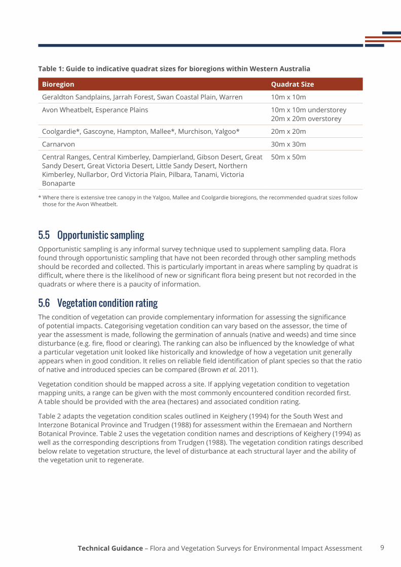
Table 1 provides indicative quadrat sizes for the biogeographic regions of Western Australia, based on commonly used quadrat sizes for regional surveys in those regions.
9Technical Guidance – Flora and Vegetation Surveys for Environmental Impact Assessment
Table 1: Guide to indicative quadrat sizes for bioregions within Western Australia
Bioregion Quadrat Size
GeraldtonSandplains,JarrahForest,SwanCoastalPlain,Warren 10m x 10m
AvonWheatbelt,EsperancePlains 10m x 10m understorey 20m x 20m overstorey
Coolgardie*, Gascoyne, Hampton, Mallee*, Murchison, Yalgoo* 20m x 20m
Carnarvon 30m x 30m
Central Ranges, Central Kimberley, Dampierland, Gibson Desert, Great Sandy Desert, Great Victoria Desert, Little Sandy Desert, Northern Kimberley,Nullarbor,OrdVictoriaPlain,Pilbara,Tanami,VictoriaBonaparte
50m x 50m
* Where there is extensive tree canopy in the Yalgoo, Mallee and Coolgardie bioregions, the recommended quadrat sizes follow those for the Avon Wheatbelt.
5.5 Opportunistic samplingOpportunistic sampling is any informal survey technique used to supplement sampling data. Flora found through opportunistic sampling that have not been recorded through other sampling methods should be recorded and collected. This is particularly important in areas where sampling by quadrat is difficult,wherethereisthelikelihoodofneworsignificantflorabeingpresentbutnotrecordedinthequadrats or where there is a paucity of information.
5.6 Vegetation condition rating Theconditionofvegetationcanprovidecomplementaryinformationforassessingthesignificanceof potential impacts. Categorising vegetation condition can vary based on the assessor, the time of year the assessment is made, following the germination of annuals (native and weeds) and time since disturbance(e.g.fire,floodorclearing).Therankingcanalsobeinfluencedbytheknowledgeofwhata particular vegetation unit looked like historically and knowledge of how a vegetation unit generally appearswheningoodcondition.Itreliesonreliablefieldidentificationofplantspeciessothattheratioofnativeandintroducedspeciescanbecompared(Brownet al. 2011).
Vegetation condition should be mapped across a site. If applying vegetation condition to vegetation mappingunits,arangecanbegivenwiththemostcommonlyencounteredconditionrecordedfirst.A table should be provided with the area (hectares) and associated condition rating.
Table 2 adapts the vegetation condition scales outlined in Keighery (1994) for the South West and InterzoneBotanicalProvinceandTrudgen(1988)forassessmentwithintheEremaeanandNorthernBotanicalProvince.Table2usesthevegetationconditionnamesanddescriptionsofKeighery(1994)aswell as the corresponding descriptions from Trudgen (1988). The vegetation condition ratings described below relate to vegetation structure, the level of disturbance at each structural layer and the ability of the vegetation unit to regenerate.

10 Technical Guidance – Flora and Vegetation Surveys for Environmental Impact Assessment
Table 2: Vegetation Condition Scale (adapted from Keighery 1994 and Trudgen 1988)
Vegetation Condition
South West and Interzone Botanical Provinces
Eremaean and Northern Botanical Provinces
Pristine Pristineornearlyso,noobvioussignsofdisturbance or damage caused by human activities since European settlement.
Excellent Vegetation structure intact, disturbance affectingindividualspeciesandweedsare non-aggressive species. Damage totreescausedbyfire,thepresenceofnon-aggressive weeds and occasional vehicle tracks.
Pristineornearlyso,noobvioussignsofdamage caused by human activities since European settlement.
Very Good Vegetation structure altered, obvious signs of disturbance. Disturbance to vegetation structurecausedbyrepeatedfires,thepresence of some more aggressive weeds, dieback, logging and grazing.
Some relatively slight signs of damage caused by human activities since European settlement. For example, some signs of damage to tree trunks caused byrepeatedfire,thepresenceofsomerelatively non-aggressive weeds, or occasional vehicle tracks.
Good Vegetationstructuresignificantlyalteredbyvery obvious signs of multiple disturbances. Retains basic vegetation structure or ability to regenerate it. Disturbance to vegetation structurecausedbyveryfrequentfires,thepresence of very aggressive weeds, partial clearing, dieback and grazing.
More obvious signs of damage caused by human activity since European settlement, including some obvious impact on the vegetation structure such as that caused by low levels of grazing or slightly aggressive weeds.
Poor Still retains basic vegetation structure or ability to regenerate it after very obvious impacts of human activities since European settlement, such as grazing,partialclearing,frequentfiresoraggressive weeds.
Degraded Basicvegetationstructureseverelyimpacted by disturbance. Scope for regeneration but not to a state approaching good condition without intensive management. Disturbance to vegetation structurecausedbyveryfrequentfires,the presence of very aggressive weeds at high density, partial clearing, dieback and grazing.
Severely impacted by grazing, veryfrequentfires,clearingoracombination of these activities. Scope for some regeneration but not to a state approaching good condition without intensive management. Usually with a number of weed species present including very aggressive species.
Completely Degraded
The structure of the vegetation is no longer intact and the area is completely or almost completely without native species. These areas are often described as ‘parkland cleared’withthefloracomprisingweedor crop species with isolated native trees and shrubs.
Areas that are completely or almost completely without native species in the structure of their vegetation; i.e. areas thatareclearedor‘parklandcleared’withtheirfloracomprisingweedorcrop species with isolated native trees or shrubs.

11Technical Guidance – Flora and Vegetation Surveys for Environmental Impact Assessment
6.0 Survey design Knownorlikelyenvironmentalvalues,natureoftheenvironment,floraandvegetationbeingtargetedand level of existing information are used to determine the type of survey and subsequent survey design.Surveydesignwillalsobeinfluencedbyarangeoffactorsrelatingtothebioregionbeingsurveyed.
Thefactorsmayvarybetween,andwithin,bioregions(Figure1)includingvariabilityofclimate,floraldiversity and endemism, patterning in vegetation units, seasonal variation in detectability, distribution of restricted landforms or soil types and extent of historical disturbance.
Survey design should consider and, where possible, mirror the method applied in relevant regional studies to ensure results are comparable, including equal or greater intensity of sampling (e.g. one or multiple sampling events).
Mostimportantly,thesurveydesignshouldbeadequatelyexplainedandjustifiedinthemethodssection of the survey report.

12 Technical Guidance – Flora and Vegetation Surveys for Environmental Impact Assessment
LSD01
CEK03
SWA01
SWA02
MUR01
GSD02
GID01
GVD02
GSD01
LSD02
PIL01
GAS03
NUL02
MUR02
PIL03
AVW01COO02
CAR02
NUL01
NOK01
COO03
GVD01
DAL02
CER01
GAS02
MAL02
CEK01
GVD03
YAL02
MAL01
GAS01
DAL01
GID02
OVP02
AVW02
JAF02
TAN01
PIL02CAR01
CEK02
NOK02
JAF01
VIB01
OVP01
GES01
ESP01
YAL01
GES02
HAM01
°
Key to Biogeographic Regions (IBRA) *
* numbers on the map refer to the sub-regions within the IBRA biogeographic regions
0 100 200 300 400 50050km
AVW Avon Wheatbelt GID Gibson Desert NOK Northern KimberleyCAR Carnarvon GSD Great Sandy Desert NUL NullarborCEK Central Kimberley GVD Great Victoria Desert OVP Ord Victoria PlainCOO Coolgardie HAM Hampton PIL PilbaraCER Central Ranges ITI Indian Tropical Islands SWA Swan Coastal PlainDAL Dampierland JAF Jarrah Forest TAN TanamiESP Esperance Plains LSD Little Sandy Desert VIB Victoria BonaparteGAS Gascoyne MAL Mallee WAR WarrenGES Geraldton Sandplains MUR Murchison YAL Yalgoo
ESP02
WAR01
PIL04
GSD02
GVD04
ITI03
COO01
Botanical Provinces of Western AustraliaEremaean
Northern
South-West
South-Western Interzone
Oceanic
Figure 1: Botanical Provinces of Western Australia (Beard 1980) with biogeographic regions (Commonwealth of Australia 2012)

13Technical Guidance – Flora and Vegetation Surveys for Environmental Impact Assessment
6.1 Survey areaTheareasurveyedshouldbesufficienttoprovideadequateinformationtoassessdirectandindirectimpacts.Forexample,aproposalincludingaborefieldrequiressurveyinareaswherethereisariskthatgroundwaterdrawdownmayaffectfloraandvegetationaswellasthoseareasclearedforinfrastructure.
Botanistsmustensurethatanadequateareahasbeensurveyedtoenableassessmentofallimpactstofloraandvegetation.Thesizeofthesurveyareawillvarydependingontheavailabilityofexistingsurvey information and scale of potential impacts. It may be necessary to survey beyond the proposal area to provide a local and regional context, particularly in an area or region that has been subject to minimalsurveyeffort.
6.2 Survey effortThesurveyeffortshouldbeadequatetocharacterisethefloraandvegetationwithinthesurveyarea.Whilesurveyeffortcanbeestimatedbasedoninformationgatheredinthedesktopstudy,thefinaldecision on the appropriate sampling techniques, capture scale for vegetation mapping and amount of time required to sample the survey area should be determined based on the variability of landforms, floraandvegetationunitsencounteredinthefield.
Surveyeffortforareconnaissancesurveywillbelowerthanthatrequiredforatargetedordetailedsurvey. In most cases, sampling techniques such as traverses or opportunistic sampling will provide sufficientsurveyeffortforareconnaissancesurvey.
Quadrat sampling is necessary for a detailed survey. The number of quadrats required will be dependent on the diversity of vegetation units present, heterogeneity within these vegetation units, the size of the vegetation units mapped and the size of the survey area. A minimum of three quadrats should be sampled in each vegetation unit. Quadrats within a widespread vegetation unit should be located to sample throughout its geographic range therefore the number of quadrats required within a vegetation unit is proportional to the area (hectares) of the unit.
Botanistsmustdemonstratethatadequatesamplingefforthasbeenundertakentoenableanassessmentoftheproposal’simpactsonfloraandvegetation.Thesurveyeffortshouldalsoconsiderthe number of quadrats required for adequate replication in data analysis. Species accumulation curves will generally indicate if an area has been adequately sampled.
When undertaking a detailed survey, a botanist should not rely on quadrats to obtain a comprehensive inventory of an area. Opportunistic collections, systematic transects and targeted inspections of potential habitat are also required to verify that the survey area has been well characterised and importantvaluesidentified.
Itmayalsobeappropriatetoincreasethesurveyeffortinareasthatappeartohaveunusualhabitatorpotentialtoprovidehabitatforsignificantfloraorvegetation,suchaspermanentorephemeralwetlands,saltlakes,rockyoutcrops,claypans,unusualgeologiesandcliffs.Insuchareas,itmaybe appropriate to install additional quadrats, survey along a transect and/or expend more time on opportunistic sampling (Figure 2).

14 Technical Guidance – Flora and Vegetation Surveys for Environmental Impact Assessment
Figure 2: Example of increased survey intensity for salt lakes
6.3 Site selectionSiteselectionisakeyaspectofsurveydesignandfieldsamplingasitdeterminestheextenttowhichfloraandvegetationcanbedefined.Theaimofsiteselectionistocharacterisethefloraandvegetationunits within the survey area by collecting data at appropriate locations for the purpose of the survey.
For a reconnaissance survey, site selection should validate and elaborate on the desktop study information and map the vegetation units at a broad scale.
Siteselectionforatargetedsurveyshouldbeguidedbythehabitatpreferenceofthefloraorvegetation being targeted.
In a detailed survey, sampling sites should be placed at representative locations throughout the survey area considering landform, geology, elevation, slope, aspect, surface or groundwater expression, and soil type, as well as structure, composition and condition of vegetation.
Sampling sites should be positioned to avoid the boundary or transition zone between vegetation units andtominimisetheinfluenceofedgeeffects.
Aerial photography is useful during survey design to determine the general location of sampling sites basedonvisualvegetationunitdefinition.Interpretationofvegetationboundariesandselectionofsampling sites should be conducted with the use of aerial photography at 1:10,000 – 1:40,000 scale. Thenumberandlocationofsitesmayrequireadjustmentifvariationsinfloristicpatterningbecomeevident during the survey, or if access or safety issues are encountered.

15Technical Guidance – Flora and Vegetation Surveys for Environmental Impact Assessment
6.4 Survey timingSurveysshouldbeconductedduringtheseasonthatismostsuitablefordetectionandidentificationoftherangeoffloralikelytooccurinthesurveyarea.Thisisparticularlyimportantwhereephemeralorcrypticfloramaybethetargetofsurvey.
Table3providessurveytimingbasedontheBotanicalProvince(Figure1)inwhichthesurveyareaislocated. Optimal survey timing may vary from year to year according to the occurrence of major ‘break ofseason’rainfalleventsintheEremaeanandNorthernBotanicalProvinces.TheamountandtimingofwinterrainfallmayimpactonappropriatesurveytimingintheSouth-WestandInterzoneBotanicalProvince.Flexibilityinsurveytimingmayberequiredtoensurethebestchanceofdetectionandcollection of adequate survey data.
Asurveyundertakenintheoptimaltimeisdefinedastheprimarysurvey.Morethanoneprimarysurveymayberequirediftheareatobesurveyedisaffectedbyflooding,droughtorfire.Supplementarysurveyisundertakenduringsecondarypeaksinrainfallorthefloweringperiodforadditionalsuitesofspeciesand is commonly used to supplement the data collected in the primary survey.
Table 3: Recommended survey timing for vegetation surveys for each Botanical Province
Botanical Province Primary survey (approximate timing)
Supplementary survey (approximate timing)
South-West and Interzone Spring (September – November)
After Autumn rains
Eremaean 6-8 weeks post wet season (March – June)
Dry season survey (After Winter rainfall if available)
Northern Wet season (January – March)
Postwetseason
In periods of below average rainfall, supplementary sampling in succeeding years (with suitable rainfall) may be necessary to compensate for low diversity recorded during a survey (especially ephemeral species). This will be highly desirable in cases where drought is prolonged or in the absence of a range of species that might normally be expected in the environment.
6.5 Flora population census Thesizeandextentofsignificantflorapopulationscanbedeterminedusingvarioustechniques.Detailedcountsandanunderstandingofareaofoccupancyofsignificantfloraaregenerallyrequired;howeverestimates(usingappropriatetechniques)maybesufficientforlargeorwidespreadpopulations.Detailedcountswillberequiredwheresignificantimpactsareindicated(Section4.2).MoreinformationaboutappropriatemethodsisavailableintheParksandWildlife’sThreatened and Priority Flora Report Form - Field Manual(DepartmentofParksandWildlife2010).
Survey design for population census should consider relevant techniques including individual counts along a traverse, transect or in a quadrat to estimate density where the boundary of a population is known.Establishingtheboundariesofapopulationofasignificantfloraanddeterminethemeandensities of plants (with range) within those areas of occupancy may be more useful and relevant to impact assessment than locating every individual plant.
Lessconspicuousflorasuchasannualsorgeophytesandcrypticordisturbancesensitivespecies(whetherthreatened,priorityorotherwisesignificant)willrequiremoreintensivesurveyeffort.

16 Technical Guidance – Flora and Vegetation Surveys for Environmental Impact Assessment
6.6 Linear corridor survey Detailed surveys of linear infrastructure should incorporate vegetation unit characterisation of an area from 500 m to 1,000 m on both sides of the infrastructure corridor (where this is not already part of the survey area) to provide context for EIA. Vegetation unit extrapolation can be undertaken using survey data and aerial photography.
Itshouldbepossible,inmostcases,toidentifysuitablehabitatforsignificantfloraandvegetationduring the survey and conduct more detailed targeted searches as appropriate.
17Technical Guidance – Flora and Vegetation Surveys for Environmental Impact Assessment
7.0 FloraIt is essential that survey reports use consistent and recognised nomenclature. Nomenclature shouldfollowthecontemporaryWesternAustralianPlantCensus.Wherethereisuncertaintywithidentificationsorapotentialnewspeciesisidentified,everyeffortshouldbemadetoresolvepreliminary taxonomic uncertainty by consulting with the Western Australian Herbarium.
7.1 CollectionandidentificationofspecimensThecollectionoffloraisacriticalaspectofsurveytoensurespecimenscanbeindependentlyverifiedata later date and in providing a permanent record of a species distribution. Multiple specimens should becollectedwherefloraappearstobeunusualormaybeoutsideitsknownrange.
Details of appropriate methods for collecting and drying specimens suitable for submission to the Western Australian Herbarium are available on the Western Australian Herbarium website. Specimens should be collected and presented in a manner consistent with the information. Information on submitting specimens to the Herbarium is also available on the Western Australian Herbarium website.
Identificationofspecimensshouldbeundertakenusingtaxonomickeys(publishedinbooks,journalsand CDs), comparison with herbarium specimens and consultation with taxonomic experts. Specimen identificationskillsvarywidelyamongindividualsandbetweenprojects,dependingonfactorssuchasexperiencewiththeflora,qualityofspecimenscollectedinthefieldandtimelinesforprojects.ThequalityofspecimenidentificationsisacriticalaspectofqualitycontrolinEIA.Ifspecimensareincorrectlyidentified,theentirebasisofanEIAprocessisflawed,anddecisionsarisingfromtheprocesscompromised.Seekingexpertadviceonspecimenidentification,whererequired,providesgreaterconfidenceintheoutcomes.
7.2 VoucheringThe Western Australian Herbarium may request collection and vouchering of species in certain bioregions that may be under-collected or otherwise of value to the collection. The following should be vouchered in all surveys:
• specimensofnewpopulationsofthreatenedandpriorityflora;• specimensofkeyspeciesinnewoccurrencesofTECsandPECs;• specimens that appear to represent new species or that have atypical characteristics; and,• specimens of bioregional range extensions, including introduced (weed) species.
7.3 New speciesAnissueinfloraandvegetationsurveyistheuncertaintyofthesignificanceofnewspeciesandhow this may impact on assessment. The Western Australian Herbarium should be consulted on all specimensconsideredtohavepotentialtobenewspeciesoranomalousfloraspecimens.
Ifanewfloraspeciesisconfirmedorsuspected,targetedsurveysshouldbeundertakentoquantifynumbers of individuals and populations. The preferred habitat of the new species within the survey area should be described.
ThereisnoexpectationthatnewspeciestaxonomywillbefinalisedduringtheEIAprocess.

18 Technical Guidance – Flora and Vegetation Surveys for Environmental Impact Assessment
8.0 Vegetation Vegetationclassificationistheprocessofidentifyingandcharacterisingdiscretevegetationunitsusingempiricaldata.TheaimofvegetationclassificationinEIAistoidentifyanddescribethevegetationunitspresentwithinasurveyarea,identifythelocalorregionalsignificanceoftheidentifiedunitsandtoprovidesufficientinformationtoenableanalysisofthesignificanceofimpacts.
Two primary methods are used to classify vegetation units in Western Australia: one is based ondominantspeciesandvegetationstructureandtheotherisbasedonanalysisoffloristiccomposition data.
Aconsistentapproachtovegetationclassificationanddescriptionacrosssurveysinsimilarregionsiscriticalfortheassessmentofcumulativeimpactsatthelocalandregionalscale.Differencesinclassificationandanalysismethods,considerationofscale,interpretationoffloristicandstructuralvegetation information and terminology can lead to incompatibility. The approach outlined below provides a repeatable and consistent approach for Western Australia that is also consistent with national standards.
8.1 StructuralvegetationclassificationStructuralvegetationclassificationusesvegetationstructureanddominantspeciestodescribedifferencesbetweenvegetationunits.Structuralvegetationclassificationprovidesinformationonheight of strata, foliar cover and dominant species.
Structurallybasedclassificationisacceptableforreconnaissancesurveys.Lowlevelpreliminaryclassificationofstructuralvegetationunitsmaybedescribedfromadesktopstudyandconfirmedoramendedduringfieldwork.Finalclassificationshouldbeconfirmedfromlowintensityfieldsampling,such as traverses and relevés.
8.2 FloristiccompositionvegetationclassificationFloristiccompositionvegetationclassificationcanbeusedtodescribevegetationunitsbasedonanalysis of species recorded in sampling sites. Surveys in areas with high species turn-over within short distances, such as kwongan heaths, banded iron formation ranges of the Yilgarn Craton and the Swan CoastalPlainbioregion,havedemonstratedthatfloristicpatterningiskeytodescribingvariationinthesub-canopy.
Floristiccompositionvegetationclassificationisthepreferredclassificationsystemforadetailedsurveyasthemethodisrepeatableandisconsideredmoresuitableforidentificationofsignificantvegetationas it focuses on the suite of species present within a quadrat.
Botanistsshoulduseappropriateanalysistechniquesandsoftwareandprovidearationalefortheirdata treatments and interpretations. In some instances it may be necessary to seek the advice or services of an experienced practitioner for appropriate techniques, analysis and the interpretation of results. If expertise is sought, this should occur prior to data collection to ensure all data required for optimal analysis techniques are available.
When comparing quadrat data with data from another survey, it is recommended that only species presence/absencedatabeused,asvariationincoverestimatesmaysignificantlyaffecttheanalysis.Ensuring that all taxon names are representative of the same nomenclature is critical for analyses involving multiple data sources (data reconciliation). When interpreting the results of analysis from multipledatasources,considerationshouldalsobegiventotheinfluenceofdifferencesinsurveyeffort,timingofsurvey,seasonalconditionsanddisturbancehistory.

19Technical Guidance – Flora and Vegetation Surveys for Environmental Impact Assessment
Useofdifferentelementsofthedatamaybeconsideredincomplementarystatisticalanalysis,suchasannuals, singletons, cover and/or opportunistic collections. Ephemeral species should be included in dataanalysesforclassificationinareaswheretheymayclarifyvegetationpatterning(suchastheSwanCoastalPlain)andexcludedwheretheycanobscurevegetationpatterning(suchastheGoldfields)or where ephemeral species can occupy a range of vegetation types. Ephemeral species should be excludedwhenusingdatacollectedovermultiplesurveyseasonsorlongperiods,whichmayaffectephemeralexpression/identification.Singletonsmayclarifypatternsindifferentcircumstances,particularlywheretheymaydominateagivenvegetationunitorhaveothersignificance.Indicatorspecies analysis may also be useful.
Multivariate comparative (cluster) analysis should be performed on a species-by-site matrix to measure the similarity between sites based on the presence or absence of species. A clearly legible dendrogram (Figure 3) should be produced to illustrate the similarities between the vegetation units that have beenidentified.
Decisions made during data interpretation require the judgement of a botanist who is experienced in thebioregion.Thebasisforsimilaritiesanddifferencesbetweenvegetationunitsshouldbedescribed.Any correlation that exists between vegetation unit and landform, soil types, subcropping and outcroppinggeology,hydrology,periodsincefire,grazingandrainfallhistoryshouldbeconsideredindescribingdifferencesbetweenvegetationunits.Theimpactofvegetationconditionontheoutcomesofanalysisshouldalsobeidentified.

20 Technical Guidance – Flora and Vegetation Surveys for Environmental Impact Assessment
Figure 3: Example dendrogram (PATN, Belbin 2003) showing floristic and super group

21Technical Guidance – Flora and Vegetation Surveys for Environmental Impact Assessment
Thegroupingoffloristicallysimilarvegetationunitsatabroadscale(supergroup)shouldbeusedwhenpresentingregionalfloristiccompositionclassificationinformation(Figure3).Vegetationunitsthatarestatisticallydistinctatafinescale(floristicgroup)aresuitabletoclassifyvegetationatalocalscale.
Thelevelatwhichfloristicandsupergroupsaredefinedshouldbemadebasedondataanalysisandexperience.Interpretationofthedendrogramshouldbeinformedbyextensiveanddetailedfieldobservations and supported by the relationship of the vegetation units to landform, geology, soils and hydrological conditions.
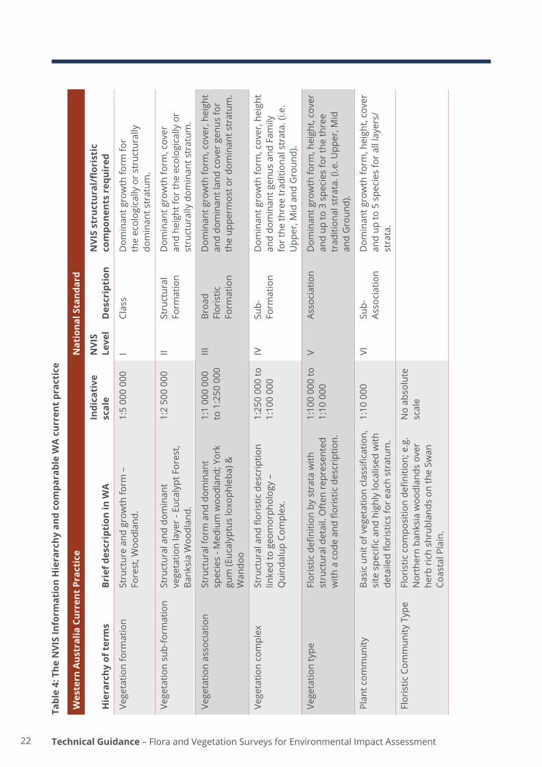
8.3 Vegetation descriptionThe National Vegetation Information System (NVIS) (ESCAVI 2003) is the nationally adopted classificationsystemandshouldbeusedforvegetationdescriptionforEIAinWesternAustralia.The use of a nationally accepted standard for documenting vegetation information provides consistency and comparability between data across a wide range of surveys, which will contribute to an improved understanding of the vegetation at a range of levels (local, regional, state, national) over time. This is particularly important for EIA where cumulative impacts across bioregions need to be considered. Current practice vegetation description in Western Australia and comparable NVIS classificationhierarchyispresentedinTable4.
Local scale vegetation units should be described at NVIS Level V - Association. The term “Vegetation Type” should be used for local scale vegetation units as “Vegetation Association” is commonly used at the regional scale in Western Australia. In areas where no existing regional data is available, vegetation unitsshouldbedescribedatNVISLevelIII–BroadFloristicFormationforregionalscaleandcumulativeimpactassessment.Wherevegetationunitsofknownsignificancewillbeimpacted,theyshouldbedescribed and mapped at the scale used in the report in which the vegetation unit was originally described.
The description of each vegetation unit should be representative of the entire area and not just the location of a quadrat. The accepted level of variability within and between vegetation units should be assessed and described. Where vegetation units contain more than one structural grouping, the range of structural variation should be presented in the description. The presence of mosaic units or smaller unitswithinbroaderscalevegetationunitsshouldalsobeclearlyidentified.
22 Technical Guidance – Flora and Vegetation Surveys for Environmental Impact Assessment
Tabl
e 4:
The
NVI
S In
form
atio
n H
iera
rchy
and
com
para
ble
WA
cur
rent
pra
ctic
e
Wes
tern
Aus
tral
ia C
urre
nt P
ract
ice
Nat
iona
l Sta
ndar
d
Hie
rarc
hy o
f ter
ms
Brie
f des
crip
tion
in W
AIn
dica
tive
sc
ale
NVI
S Le
vel
Des
crip
tion
NVI
S st
ruct
ural
/flor
isti
c co
mpo
nent
s re
quir
ed
Vege
tatio
n fo
rmat
ion
Stru
ctur
e an
d gr
owth
form
–
Fore
st, W
oodl
and.
1:5
000
000
ICl
ass
Dom
inan
t gro
wth
form
for
the
ecol
ogic
ally
or
stru
ctur
ally
do
min
ant s
trat
um.
Vege
tatio
n su
b-fo
rmat
ion
Stru
ctur
al a
nd d
omin
ant
vege
tatio
n la
yer
- Euc
alyp
t For
est,
BanksiaWoo
dlan
d.
1:2
500
000
IISt
ruct
ural
Fo
rmat
ion
Dom
inan
t gro
wth
form
, cov
er
and
heig
ht fo
r th
e ec
olog
ical
ly o
r st
ruct
ural
ly d
omin
ant s
trat
um.
Vege
tatio
n as
soci
atio
nSt
ruct
ural
form
and
dom
inan
t sp
ecie
s - M
ediu
m w
oodl
and;
Yor
k gu
m(Eucalyptusloxoph
leba
)&
Wan
doo
1:1
000
000
to 1
:250
000
IIIBroa
dFl
oris
tic
Form
atio
n
Dom
inan
t gro
wth
form
, cov
er, h
eigh
t an
d do
min
ant l
and
cove
r ge
nus
for
the
uppe
rmos
t or
dom
inan
t str
atum
.
Vege
tatio
n co
mpl
exStructuraland
floristicdescriptio
nlin
ked
to g
eom
orph
olog
y –
Qui
ndal
up C
ompl
ex.
1:25
0 00
0 to
1:
100
000
IVSu
b-Fo
rmat
ion
Dom
inan
t gro
wth
form
, cov
er, h
eigh
t an
d do
min
ant g
enus
and
Fam
ily
for
the
thre
e tr
aditi
onal
str
ata.
(i.e
. U
pper
, Mid
and
Gro
und)
.
Vege
tatio
n ty
peFloristicdefi
nitio
nbystratawith
st
ruct
ural
det
ail.
Oft
en r
epre
sent
ed
with
acod
ean
dflo
risticdescriptio
n.
1:10
0 00
0 to
1:
10 0
00V
Asso
ciat
ion
Dom
inan
t gro
wth
form
, hei
ght,
cove
r an
d up
to 3
spe
cies
for
the
thre
e tr
aditi
onal
str
ata.
(i.e
. Upp
er, M
id
and
Gro
und)
.
Plan
tcom
mun
ityBa
sicun
itofvegetationclassification,
sitespe
cificand
highlylocalised
with
de
tailedflo
risticsforeachstratum
.
1:10
000
VISu
b-As
soci
atio
nD
omin
ant g
row
th fo
rm, h
eigh
t, co
ver
and
up to
5 s
peci
es fo
r al
l lay
ers/
stra
ta.
Flor
istic
Com
mun
ity T
ype
Floristiccom
positio
nde
finition
;e.g.
Nor
ther
n ba
nksi
a w
oodl
ands
ove
r he
rb r
ich
shru
blan
ds o
n th
e Sw
an
CoastalPlain.
No
abso
lute
sc
ale

23Technical Guidance – Flora and Vegetation Surveys for Environmental Impact Assessment
8.4 DefiningThreatenedandPriorityEcologicalCommunitiesTheDepartmentofParksandWildlifeshouldbeconsultedregardinginformationfordeterminingTECsorPECsandwhereadviceisneededastowhethervegetationunitsarerepresentativeoflistedTECsorPECs.AnalysisofwhethervegetationunitsdescribedinthesurveyarearepresentTECsorPECsisasignificantpartofthevegetationclassificationprocessforEIA.Informationgatheredduringthe database and literature search stage of the desktop study should provide an early indication as to whetheranyknownTECsorPECsoccurwithinthesurveyarea.
TECsandPECsmaybedescribedandlistedatanumberofscales.Forexample,communitiescanbedescribed at a regional scale which incorporates many vegetation units (e.g. Vegetation Complexes of theFinnertyRanges),regionalscaledescribingalargeareaofpotentialoccupancy(e.g.HorseflatlandsystemoftheRoebournePlainsPEC)tolocalscaledescriptions(e.g.SedgelandsinHoloceneduneswalesofthesouthernSwanCoastalPlain).
Aswithpriorityflora,thePEClistingmayreflecttheleveloflocalandregionalsurveyinformationavailable,andthedefinitions,descriptionsandscalesofthecommunitiesdescribedmaybeamendedovertimeasbetterinformationbecomesavailable.WhereTECsorPECsaredefinedatalocalscale,theobjectiveofthevegetationclassificationwillbetodeterminewhetherandwheretheseoccurwithinthesurveyarea.WheretheTECorPECisdefinedataregionalscale(association,alliance,complex,systemorbroader),vegetationsub-unitsofthelistedecologicalcommunityshouldbeidentifiedsothattheoverallimpactonthebiodiversityvaluesoftheTECorPECcanbeevaluated.
WherevegetationunitsfallwithinthedefinitionormappedextentofadescribedTECorPEC,qualitative or spatial comparison should be completed using the description and/or documented locationoftheTECorPEC.IdentificationofTECsorPECsshouldbeundertakenusingformaldescriptions of these ecological communities.
WhereTECsorPECshavebeendescribedfromquadrat-deriveddata,similarityshouldbedeterminedbycomparingdatafromthesurveyquadratswithdatafromthesurveyinwhichtheTECorPECwasidentified.ThesedataareoftenavailableintheliteratureordirectlyfromParksandWildlife.The datasets from Gibson et al. (1994)andBushForever(2000)areavailablefordownloadfromNatureMapandnotesonsurveyandanalysismethodstodeterminefloristiccommunitytypesonthesouthernSwanCoastalPlainarealsoavailablefromParksandWildlife.

24 Technical Guidance – Flora and Vegetation Surveys for Environmental Impact Assessment
9.0 MappingTheresultsofasurveyshouldbemappedtopresentinformationsuchassurveyeffort,distributionofvegetationunits,significantvegetationandpopulationsofsignificantflorainthesurveyareaandprovidecomplementaryinformationtodeterminethesignificanceofimpact.
All maps should be legible, with an explanatory title and current information. Aerial photography should be the base layer for most maps with the subject of the map overlaid with transparent colours and labelled features. Colours of features and/or shapes of point symbols should be readily distinguishable from one another. The colours or textures used to indicate recurring features (e.g. impact footprint) should be consistent for all maps within the survey report. See Figure 4 for an example map showing minimum features. The scale of maps will vary depending on the size of the survey area, spatial heterogeneity of vegetation and amount of information that needs to be displayed.
The suite of maps presented in survey reports should include the following information (where relevant):
• an inset or separate map showing the location and extent of the survey area in a meaningful regional context (e.g. major roads, rail, Local Government Area boundaries);
• land system, soil or geological mapping for the survey area;• mapping of the regional vegetation units, or other relevant dataset illustrating the
regional context; • the extent of previous surveys and known disturbance history;• samplingeffortdepictedusingGPStrackingdataand/orlocationofsamplingsites;• distribution of vegetation units within the survey area with location of all sampling sites; • localandregionaldistributionsofallsignificantflora.Ifpopulationsmaybeimpacted,finescale
mapswillberequiredtoprovidesufficientdetail;• localandregionaldistributionsofallsignificantvegetation.Ifoccurrencesmaybeimpacted,fine
scalemapswillberequiredtoprovidesufficientdetail;and• vegetation condition mapping (if applicable, see Section 5.6).
Significantspecieswhichmaybesubjecttolowerlevelsofimpactmaybemappedwithlessaccuracythan those subject to high levels of impact.

25Technical Guidance – Flora and Vegetation Surveys for Environmental Impact Assessment
The
follo
win
g da
tase
ts a
re n
ot d
ispl
ayed
on
this
map
as
they
cov
er th
em
ap e
xten
t:Tr
opic
al A
rid Z
one
Man
grov
es (2
001)
Map
Dat
e
S
S
S
S
S
S
S
S
S
S
SS
S
S
S
S
S
S
SS
S
S
S
SSS
S
S
S
SS
S
S
S
S
T3
W1
S1
T1
W1
A2
W2 S
1
S3
W2
W2
W1
T3
W2
A1
S3
A2
A2
S3
S1
S1
A1
A2
T1
A2
A2
W1
S3 S
3
A1
S3
R1
T2
S1
W2
W2
W2
W1
R1
R1
T2
A2
W2
T2
LOC
ALI
TY M
AP
Exa
mpl
e M
ap fo
r Inf
orm
ativ
e P
urpo
ses
Onl
yP
rodu
ced
by: O
EPA
GIS
Sec
tion,
Sep
t 201
5
TOW
N
Figu
re 4
: Exa
mpl
e m
ap s
how
ing
min
imum
feat
ures
LEG
END
Min
e Pl
anni
ngD
evel
opm
ent E
nvel
ope
Hau
l Roa
dM
ine
Pit
Pla
nt a
nd R
OM
Was
te R
ock
Dum
pVe
geta
tion
Uni
tsA
1A
2R
1S
1S
3T1 T2 T3 W
1W
2S
Qua
drat
s
!BM
INE
X
HIG
HW
AY
LOC
ALI
TY M
AP
TOW
N!B
MIN
E X
HIG
HW
AY
080
160
40
Met
res¯
PR
OJE
CTI
ON
:D
ATU
M:
SC
ALE
:
Figure 4: Example map showing minimum features

26 Technical Guidance – Flora and Vegetation Surveys for Environmental Impact Assessment
10.0 Reporting The structure, content and detail of the survey report should be based on the objective/s of survey.
Thesurveyreportshouldbeanaccuratereflectionoftheinformationgainedthroughsurvey,rationalinterpretation of the survey results and demonstrate that contemporary survey methods and guidance have been used.
The survey report should be prepared by the botanist involved in planning and conducting the survey wherepossibleorshouldbebasedoninterpretationbyaprofessionalinthisfield.Anysignificantchangestothereportbythosenotinvolvedinthesurveyshouldbejustified.
The executive summary should be a succinct overview of the purpose of the survey, methods employed, key results and conclusions.
10.1 IntroductionThe introduction should contain a clear statement of the objectives of the survey, the proposal and the area (hectares) of survey. Regional information such as location, climate, biogeography and disturbance history should be presented in this section.
Backgroundinformationgatheredduringthedesktopstudyshouldbepresentedinthissection,including summaries of the results of previous studies in the area and database searches.
10.2 MethodsAll reports should contain a section outlining the scope of the survey, the methods used and limitations ofthesurvey.Justificationofthetypeofsurveyconductedandthesurveydesign,includinganydeviation from this guidance, should be provided.
Anysurvey-specificissues/limitationsshouldbeaddressedinthelimitationssection.Thefollowinglimitations should be addressed as standard, whether they were a limitation of survey or not:
• availability of contextual information at a regional and local scale;• competency/experience of the team carrying out the survey, including experience in the
bioregion surveyed;• proportionofflorarecordedand/orcollected,anyidentificationissues;• wastheappropriateareafullysurveyed(effortandextent);• access restrictions within the survey area; • survey timing, rainfall, season of survey; and• disturbancethatmayhaveaffectedtheresultsofsurveysuchasfire,floodorclearing.
Thesurveydesign,typeofsurveyandchoiceofvegetationclassificationsystemused(structuralorfloristic)shouldbestatedandjustified.Therationaleofdatapreparationforanalysisshouldbedetailed,includingdatareconciliationordataomittedtoreduce‘noise’oroutliers.Adetaileddescriptionofthedataanalysisshouldbepresented,includingleveloffloristicandsupergroup separation.
For detailed surveys, species accumulation curves should be presented as part of survey reporting. This analysis is particularly important where species composition was inconsistent with regional data or adifferentquadratsizefromtherecommendedsizewasused.

27Technical Guidance – Flora and Vegetation Surveys for Environmental Impact Assessment
10.3 ResultsSurveyresultsshouldbepresentedintextandtabularformatsummarisingrelevantfloraandvegetation values within the survey area. Data may also be presented in graph or mapped form. Datacollectedduringsurveyshouldbeclearlydifferentiatedfromdatagatheredfrompublishedorunpublished sources and sources of information used should be clearly referenced in the report.
Informationonflorarecordedwithinthesurveyareashouldbepresentedinaflorasub-section,includingnumbersoftaxa,generaandfamilyrepresentation,conservationstatus,anysignificantweedspeciesandsignificantflora.Quantitativeinformationonthesizeandlocationofsignificantspeciesorpopulationsofsignificantspeciesrecordedwithinandoutsidethesurveyareamustbeprovided.
Informationonvegetationshouldbepresentedinavegetationsub-section.Whereclassificationandmapping is primarily based on structural features, a two-way table organised by vegetation unit is requiredtoillustratethefloristicvariationintheunits.Adendrogramshouldbepresentedwherevegetationclassificationisbasedonfloristiccomposition,withsupportingtextexplainingtheoutcomeofthevegetationclassification.Illustrations(includingdendrogram)shouldclarifyandsupportinterpretations made in the report. The clustering of the units within the dendrogram should illustrate the vegetation units described in the text. Any discrepancy between the dendrogram and described vegetation units should be explained in the text.
Quantitative information on the extent and location of vegetation types must be provided as well as a discussionofelementsrelevanttoitsdistribution,suchaslandform,soilsoraspect,associatedfloraspecies, groundwater or surface water dependence. There should also be a similar discussion of the regional vegetation units present within the survey area and relationship/s to described vegetation types.
An analysis indicating whether communities present in a survey area represent known TECs or PECsshouldbeprovided.Quantitativeinformationonthesizeandlocationofsignificantvegetationrecorded within and outside the survey area must be provided.
10.4 DiscussionAdiscussionshouldbeprovidedonthevaluesandsignificanceoffloraandvegetationidentifiedwithinthe survey area at a local and regional context. The discussion should be a synthesis of the values based on an objective interpretation of the results.
Wheresignificantvalueswereidentified,throughthedesktopstudy,aspotentiallyoccurringinthesurvey area are not found, the report should discuss possible reasons for the divergence.
10.5 ConclusionsThesurveyreportshouldconcludewithasummaryofthefindingsofthesurveyandanyrecommendations. All conclusions should be substantiated by the data and/or reference to the literature.Theinfluenceofsurveylimitationsontheresultsshouldalsobenoted.
Itisparticularlyimportanttohighlightfloraandvegetationissuestobemitigatedinplanningaproposal within the survey area, to provide advice to assist the management of potential issues (such asweeds)orwheresurveyworkisrequiredtofurtherdefinefloraorvegetationvalues.

28 Technical Guidance – Flora and Vegetation Surveys for Environmental Impact Assessment
10.6 AppendicesAppendices should include:
• a complete list of all the species recorded during the survey grouped by family;• a summary of database search results (if not already included in the report); • acleardescriptionofeachsamplingsitewithflorarecorded,allocatedvegetationunit,location
details(GPSwaypointswithdatum),sitephotographsandanyotherrelevantinformation;• a matrix of all species recorded during the survey by either vegetation type (reconnaissance,
targeted and detailed survey) and vegetation type by quadrat (detailed survey); and • any other information relevant to the survey.
Raw data should be provided electronically in tabular format (preferably MS Excel or Access) to allow for assimilation into future government reference datasets. To avoid publication of detail on conservationsignificantlocations,appendiceswithdatabasesearchesandTPRFsshouldbeidentifiedasbeingforagencyreferenceonly.

29Technical Guidance – Flora and Vegetation Surveys for Environmental Impact Assessment
11.0 GlossaryBioregion: seeInterimBiogeographicRegionalisationofAustralia(IBRA).
Context: An understanding of the survey area in relation to the local area or region. Local context should be considered at a scale that allows comparison of survey data and any detailed surveys found at desktop study. Regional contextisconsideredatabroadscale,definedbyexistingregionalstudies.
Diversity: The variety and variability of living organisms and the environment in which they occur.
Ecological community: Naturally occurring biological assemblage that occurs in a particular type of habitat.Thescaleatwhichecologicalcommunitiesaredefinedwilloftendependonthelevelofdetailintheinformationsource.Thereforenoparticularscaleisspecified(English&Blyth1999).
Ecosystem: A dynamic complex of plant, animal, fungal, and microorganism communities and the associated non-living environment interacting as an ecological unit (Commonwealth of Australia 1996). (That is, all living and non-living parts of a system and their interaction. Non-living factors include climate, atmosphere, and the geosphere.)
Endemic: Beingrestrictedtoaspecificregionorlocation.
Interim Biogeographic Regionalisation of Australia (IBRA): Categorisation of the Australian continent into regions of like geology, landform, vegetation, fauna and climate (Commonwealth of Australia 2012).
National Vegetation Inventory System (NVIS): An Australia-wide consistent framework for describing and compiling data and vegetation information.
Population:Allmembersofthesamespeciesinagivenareaofoccupancy.Plantsseparatedby>500m(orasignificantlandscapefeature)compriseaseparatepopulation
Priority ecological community:Possiblethreatenedecologicalcommunitiesthatdonotmeetthestringentsurveycriteriafortheassessmentofthreatenedecologicalcommunities,listedbyParksandWildlife.
Priority flora:PlanttaxalistedbyParksandWildlifethatareeitherunderconsiderationasthreatenedflorabutareinneedofadditionalsurveytoadequatelydeterminetheirstatus,orareadequatelyknown but require monitoring to ensure that their security does not decline.
Proposal area: The area impacted by clearing for proposal and any adjacent indirect disturbance or impacts that may result from operation, including changes to hydrology or introduction of weeds.
Range extension: The presence of a species or vegetation unit outside its previously known range.
Refugia: Habitat that through long-term isolation or as a remnant of a previously more widely distributedhabitat,mayactasanimportantrefugeforfloraandvegetationthatrequirespecificbioticor abiotic conditions.
Significant flora and vegetation:Floraandvegetationmaybeconsideredsignificantforarangeofreasons, including, but not limited to the following:
Flora
• beingidentifiedasthreatenedorpriorityspecies• locally endemic or association with a restricted habitat type (e.g. surface water or groundwater
dependent ecosystems)• new species or anomalous features that indicate a potential new species

30 Technical Guidance – Flora and Vegetation Surveys for Environmental Impact Assessment
• representative of the range of a species (particularly, at the extremes of range recently discovered range extensions, or isolated outliers of the main range)
• unusual species, including restricted subspecies, varieties or naturally occurring hybrids• relictual status, being representative of taxonomic groups that no longer occur widely in the
broader landscape.
Vegetation
• beingidentifiedasthreatenedorpriorityecologicalcommunities• restricted distribution• degree of historical impact from threatening processes• a role as a refuge• providinganimportantfunctionrequiredtomaintainecologicalintegrityofasignificant
ecosystem.Species/area curve: Number of species versus area (Lewis 1977); usually depicted as a graph.
Taxa (singular Taxon): A taxonomic grouping. Depending on context, this may be a species or one of their subdivisions (subspecies, varieties etc.), a genus or higher group.
Threatened Ecological Community (TEC): A naturally occurring assemblage of plants and animals listedbyParksandWildlife,andendorsedbytheMinisterforEnvironment,asbeingthreatenedwithextinctionbyhumanactivity,orindangerofbeingdestroyedorsignificantlymodifiedbydevelopmentand other pressures.
Threatened flora (DeclaredRareFlora–Extant,DRF):WesternAustralianfloraspeciesthathavebeenadequately searched for and are deemed to be in the wild either rare, in danger of extinction, or otherwise in need of special protection, and have been gazetted as such under the Wildlife Conservation Act 1950 – at time of writing the listing is Wildlife Conservation (Rare Flora) Notice 2014 (Government ofWesternAustralia2014).Properlyknownasthreatenedflorainaccordwithmoderninternationalpractice, they are termed Declared Rare Flora under the WC Act.
Undescribed (new flora): Species which have not yet been formally described and published in a recognised journal.
Vegetation: The various combinations that all populations of all vascular plant species form within a given area, and the nature and extent of each combination (Lewis 1977; Onions 1978). The term ‘vegetation’hasbeenappliedatarangeofscalesingeneraluse(ashave‘community’and‘habitat’).
Vegetation association:Avegetationunitdefinedonthebasisofacharacteristicrangeofspeciescomposition,diagnosticspeciesoccurrence,habitatconditionsandphysiognomydefinedbyBeard(1980).
Vegetation complex: Broad-scalevegetationunitsmostlydefinedinrelationtogeomorphology,soilsandclimaticconditionsdefinedbyHeddleetal.(1980).
Vegetation community: A term sometimes used colloquially to refer to plant communities or vegetationunits.Forthepurposesofthisdocument,vegetationunitispreferredforuseinfloraandvegetation survey reports.
Vegetation mosaic: Thepatternofdifferentvegetationunits;twoormorevegetationunitsoccurringina pattern too detailed to map separately at the scale being applied.
Vegetation unit: A generic term applied to a distinct type of vegetation regardless of scale. For the purposesofthisdocument,thisterminologyispreferredforuseinfloraandvegetationsurveyreports.

31Technical Guidance – Flora and Vegetation Surveys for Environmental Impact Assessment
Weed:Plantsthatestablishandpersistinanaturalecosystemwheretheydidnotpreviouslyexist.Weeds may, or may not, have detectable environmental or economic impacts

32 Technical Guidance – Flora and Vegetation Surveys for Environmental Impact Assessment
12.0 References Atlas of Living Australia website at http://www.ala.org.au. Accessed 4 November 2015.
Beard,J.S.(1972-1980).Vegetation survey of Western Australia, 1:250,000 vegetation series.Vegmap,Perth.
Beard,J.S.(1968-1981).Vegetation survey of Western Australia, 1:1,000,000 vegetation series. Sheets 1-7. UniversityofWesternAustraliaPress,Nedlands.
Beard,J.S.(1980).AnewphytogeographicmapofWesternAustralia.Western Australian Herbarium Research Notes 3: 37-58
Beard,J.S.,Beeston,G.R.,Harvey,J.M.,Hopkins,A.J.M.andShepherd,D.P.(2005).The vegetation of Western Australia: 1:3,000,000 map with explanatory memoir 2nd edition). Conservation Science in WesternAustralia–SpecialPublication.DepartmentofConservationandLandManagement,Perth.
Belbin,L.(2003).PATN, A revised User’s Guide.UnpublishedreportpreparedbyBlatantFabrications,Tasmania.
Brown,K.,Bettink,K.,Paczkowska,G.,Cullity,J.andFrench,S.(2011).Techniques for mapping weed distribution and cover in bushland and wetlands.StandardOperatingProcedureNo.22.1.DepartmentofEnvironment and Conservation, Western Australia.
Clarke, V. (2009a). Establishing vegetation transects. Standard Operating Procedure No. 6.2. Department of Environment and Conservation, Western Australia.
Clarke, V. (2009b). Establishing vegetation quadrats. Standard Operating Procedure No. 6.1. Department of Environment and Conservation, Western Australia.
Commonwealth of Australia (1999). Environment Protection and Biodiversity Conservation Act.
Commonwealth of Australia (2010). Australia’s Biodiversity Conservation Strategy 2010-2030. Department of the Environment, Canberra. https://www.environment.gov.au/biodiversity/conservation/strategy
Commonwealth of Australia (2012). Interim Biogeographic Regionalisation for Australia (IBRA) 7. Department of the Environment, Canberra. http://www.environment.gov.au/land/nrs/science/ibra
Department of Agriculture and Food and Department of Environment and Conservation (2012–). Pre-European Vegetation. Spatial dataset.
DepartmentofParksandWildlife(2007–).NatureMap: Mapping Western Australia’s Biodiversity. DepartmentofParksandWildlife.http://naturemap.dpaw.wa.gov.au/
DepartmentofParksandWildlife(2010).Threatened and Priority Flora Report Form – Field Manual. DepartmentofParksandWildlife.http://www.dpaw.wa.gov.au/
DepartmentofParksandWildlife(2015a).Priority ecological communities for Western Australia Version 22, 6 June 2015.DepartmentofParksandWildlife,WA.
DepartmentofParksandWildlife(2015b).List of threatened ecological communities endorsed by the Minister for the Environment, 25 June 2015. DepartmentofParksandWildlife,WA.
Executive Steering Committee for Australian Vegetation Information ESCAVI (2003). Australian Vegetation Attribute Manual: National Vegetation Information System, Version 6.0. Department of Environment and Heritage, Canberra. http://www.environment.gov.au/node/18927
Gibson,N.,Keighery,G.J.,Lyons,M.N.andWebb,A.(2004).TerrestrialfloraandvegetationoftheWestern Australian wheatbelt. Records of the Western Australian Museum Supplement 67: 139-189.

33Technical Guidance – Flora and Vegetation Surveys for Environmental Impact Assessment
Gibson,N.,Keighery,B.J.,KeigheryG.J.,Burbidge,A.H.andLyons,M.(1994).A Floristic Survey of the southern Swan Coastal Plain. Unpublished Report for the Australian Heritage Commission prepared by Department of CALM and Conservation Council of WA (Inc.).
Government of Western Australia (1950). Wildlife Conservation Act.
Government of Western Australia (1984). Conservation and Land Management Act.
Government of Western Australia (1986). Environmental Protection Act.
GovernmentofWesternAustralia(2000).Bush Forever, Volume 2 Directory of Bush Forever Sites. PublishedbytheDepartmentofEnvironmentalProtection,Perth.
Government of Western Australia (2002). Conservation and Land Management Regulations.
Government of Western Australia (2014). Wildlife Conservation (Rare Flora) Notice 2014. Government Gazette, WA, 02 December 2014.
Heddle, E.M., Havel, J.J. and Loneragan, O.W. (1980). Vegetation Complexes of the Darling System, Western Australia. In: Atlas of natural resources darling system, Western Australia. Department of ConservationandEnvironment,Perth,WA.
Hnatiuk, Thackway and Walker (2009). Vegetation. In McDonald, R.C., Isbell, R.F., Speight, J.G., Walker, J. and Hopkins, M.S. (eds.) Australian Soil and Land Survey Field Handbook (3rd edition). The National CommitteeonSoilandTerrain,CSIROPublishing,Australia.
Keighery,B.J.(1994).Bushland Plant Survey: a Guide to Plant Community Survey for the Community. WildflowerSocietyofWA(Inc.),Nedlands,WesternAustralia.
Lewis, W. H. (1977). Ecology Field Glossary: a Naturalist’s Vocabulary. GreenwoodPress,Westport,Connecticut, 152pp.
Lyons,M.N.,Gibson,N.,Keighery,G.J.,andWebb,A.(2004).WetlandfloraandvegetationoftheWestern Australian wheatbelt. Records of the Western Australian Museum Supplement 67: 39-89.
Onions, C.T. (1978). The Shorter Oxford Dictionary, on Historical Principles. ThirdEdition.ClaredonPress,Oxford.
Sandiford,E.M.andBarrett,S.(2010).Albany Regional Vegetation Survey; Extent, Type and Status. A project fundedbytheWesternAustralianPlanningCommission(EnviroPlanning“IntegratingNRMintoLandUsePlanning”andStateNRMProgram),SouthCoastNaturalResourceManagementInc.andCityofAlbany for the Department of Environment and Conservation. Unpublished report prepared by the Department of Environment and Conservation, Western Australia.
Shepherd,D.P.,Beeston,G.R.andHopkins,A.J.M.(2002).Native Vegetation in Western Australia: Extent, types and status. Department of Agriculture, Western Australia.
Thackway,R.,Neldner,V.J.andBolton,M.P.(2008).Vegetation.InMcKenzie,N.J.,Grundy,M.J.,Webster,R. and Ringrose Voase, A.J. (eds) Guidelines for surveying soil and land resources (2nd edition). CSIRO Publishing,Melbourne.
Trudgen, M.E. (1988). A Report on the Flora and Vegetation of the Port Kennedy Area. Unpublished report preparedforBowmanBishawandAssociates,WestPerth.
WAPC(2010).Geraldton Regional Flora and Vegetation Survey. WesternAustralianPlanningCommission,Perth.
Western Australian Herbarium (1998–). FloraBase — the Western Australian Flora.DepartmentofParksandWildlife.http://florabase.dpaw.wa.gov.au/http://florabase.dpaw.wa.gov.au/

34 Technical Guidance – Flora and Vegetation Surveys for Environmental Impact Assessment
Appendix A: Selected flora and vegetation survey reports for contextual referenceGeneralBeard,J.S.(1990).Plant Life of Western Australia.KangarooPress,Kenthurst,NewSouthWales.
Commonwealth of Australia (2012). IBRA 7. Department of Sustainability, Environment, Water, PopulationandCommunities,Canberra,June2012.
Department of Agriculture and Food and Department of Environment and Conservation Conservation (2012–). Pre-European Vegetation. Spatial dataset.
DepartmentofParksandWildlife(2007–).NatureMap: Mapping Western Australia’s Biodiversity. DepartmentofParksandWildlife.URL:http://naturemap.dpaw.wa.gov.au
May, J.E. and McKenzie, N.L. (2003). A biodiversity audit of Western Australia’s 53 biogeographical subregions in 2002. Department of Conservation and Land Management, Kensington WA.
Series of reports – Vegetation survey of Western Australia 1:250,000 vegetation series. Several examples are provided here, but other papers in the series cover other areas.
Beard,J.S.(1980).ThevegetationoftheCorriginarea,WesternAustralia:mapandexplanatorymemoir,1:250,000series.Vegmap,Perth.
Beard,J.S.(1972).ThevegetationoftheSouthernCrossarea,WesternAustralia:mapandexplanatorymemoir,1:250,000series.Vegmap,Perth.
Series of reports – Vegetation survey of Western Australia 1:1,000,000 vegetation series. Several examples are provided here, but other papers in the series cover other areas.
Beard,J.S.(1981).Swan:vegetationsurveyofWesternAustralia1:1,000,000vegetationseriesSheet7.UniversityofWesternAustraliaPress,Nedlands.
Beard,J.S.(1968).GreatSandyDesert:vegetationsurveyofWesternAustralia1:1,000,000vegetationseriesSheet2.UniversityofWesternAustraliaPress,Nedlands.
South-West Province and South-Western InterzoneRegionalDepartmentofPlanningandEcoscape(Australia)PtyLtd(2010).Geraldton regional flora and vegetation survey.WesternAustralianPlanningCommission,PerthWA.
Freeman,K.,Keighery,B.J,Keighery,G.J,Longman,V.M,Black,A.andMolloy,S.(2009).The flora and vegetation of the Dawesville to Binningup region (Swan Coastal Plain): a report for the Environmental Protection Authority as part of the Swan Bioplan Project.DepartmentofEnvironment&Conservation,PerthWA.
Gibson,N.,Meissner,R.,Markey,A.S.andThompson,W.A.(2012)Patternsofplantdiversityinironstone ranges in arid south western Australia. Journal of Arid Environments 77: 25-31.
Gibson,N.,Keighery,G.J.,Lyons,M.N.andWebb,A.(2004).TerrestrialfloraandvegetationoftheWestern Australian wheatbelt. Records of the Western Australian Museum. Supplement 67: 139–189.

35Technical Guidance – Flora and Vegetation Surveys for Environmental Impact Assessment
Gibson,N.,Keighery,G.J.andKeighery,B.J.(2000).ThreatenedplantcommunitiesofWesternAustralia1.TheironstonecommunitiesoftheSwanandScottCoastalPlains.Journal of the Royal Society of Western Australia 83: 1-11.
Gibson,N.,Keighery,B.J.,Keighery,G.J.,Burbidge,A.H.andLyons,M.(1994).A Floristic Survey of the southern Swan Coastal Plain. Unpublished Report for the Australian Heritage Commission prepared by Department of Conservation and Land Management and Conservation Council of WA (Inc.).
Government of WA (2000a). Bush Forever: keeping the bush in the city - final report. Volume 1, policies, principlesandprocesses.WesternAustralianPlanningCommission,Perth.
Government of WA (2000b). Bush Forever: keeping the bush in the city. Volume2,directoryofBushforeversites.DepartmentofEnvironmentalProtection,Perth.
Griffin,E.A.(1992).FloristicsurveyofremnantvegetationintheBindoontoMooraarea,WesternAustralia. Resource management technical report 142.DepartmentofAgriculture,SouthPerthWA.
Griffin,E.A.andKeighery,B.J.(1989).Moore River to Jurien Sandplain survey. Western Australian WildflowerSociety,NedlandsWA.
HearnR.,Stoneman,G.L.,Keighery,G.J.,Burrows,N.,Yates,C.andHopper,S.(2003).Management of Significant Flora values in South-west Forests and Associated Ecosystems. A report for the Conservation Commission’sForestManagementPlanSteeringCommittee.
Heddle, E.M., Loneragan, O.W. and Havel, J.J. (1980). Vegetation complexes of the Darling System, Western Australia. In Department of Conservation and Environment (ed.) Atlas of Natural Resources, Darling System, Western Australia.DepartmentofConservationandEnvironment,PerthWA.
Keating, C. and Trudgen, M.E. (1986). A Flora and Vegetation Survey of the Coastal Strip From Forrest Beach-Cape Naturaliste-Woodlands. A report for the Department of Conservation and Environment, Western Australia.
Keighery,B.J.,Keighery,G.J.,Webb,A.,andLongman,V.M.(2008).A floristic survey of the Whicher Scarp. DepartmentofEnvironmentandConservation,PerthWA.
Keighery,B.J.,Dell,J.,Keighery,G.J.,Madden,S.,Longman,V.M.,Green,B.,Webb,A.,McKenzie,B.,Hyder,B.,Ryan,R.,Clarke,K.A.,Harris,E.,Whisson,G.,Olejnik,C.andRichardson,A.(2006).The vegetation, flora, fauna and natural areas of the Peel Harvey eastern estuary area catchment (Swan Coastal Plain): a report for the Department of Environment and Conservation as a contribution to the Peel Harvey Eastern Estuary Area Catchment Environmental Assessment Project and the Swan Bioplan Project. DepartmentofEnvironmentandConservation,PerthWA.
Keighery,B.J.andLongman,V.M.(eds.)(2002).Tuart (Eucalyptus gomphocephala) and tuart communities.WildflowerSocietyofWA-PerthBranch,Nedlands,WA.
Keighery,B.JandTrudgen,M.(1992).Remnant vegetation on the alluvial soils of the eastern side of the Swan Coastal Plain.DepartmentofConservationandLandManagement,PerthWA.
Keighery, G.J. (1990). Coastal Limestone Endemics. Unpublished report for the Department of ConservationandLandManagement,Perth,WesternAustralia.
Keighery, G.J. (1999). Conservation Status of Vascular Flora of the Southern Swan Coastal Plain. Unpublished report for Australian Nature Conservation Agency National Reserves System CooperativeProgramProject:N710andDepartmentofConservationandLandManagement,Perth,Western Australia.

36 Technical Guidance – Flora and Vegetation Surveys for Environmental Impact Assessment
Keighery, G.J. (2004). State Salinity Strategy biological survey of the Western Australian wheatbelt: background. Records of the Western Australian Museum. Supplement 67: 1-6.
Lyons,M.N.,Gibson,N.,Keighery,G.J.,Lyons,S.D.(2004).WetlandfloraandvegetationoftheWesternAustralian wheatbelt. Records of the Western Australian Museum. Supplement 67: 39–89.
Markey, A. (1997). Floristic Survey of the northern Darling Scarp. Unpublished report to the WA DepartmentofCALM,theWADepartmentofEnvironmentalProtectionandtheWAConservationCouncil for the Australian Heritage Commission.
Mattiske, E.M. and Havel, J.J. (1998). Regional Forest Agreement vegetation complexes. Department of Conservation and Land Management, Como WA.
Muir,B.G.(1977).BiologicalSurveyoftheWesternAustralianWheatbelt.Pt.2.VegetationandhabitatoftheBenderingReserve.Records of the Western Australian Museum Supplement 3.
Sandiford,E.M.andBarrett,S.(2010).Albany Regional Vegetation Survey: extent, type and status. Department of Environment and Conservation, Albany WA.
Smith, F.G. (1973). Vegetation Survey of Western Australia, 1:250,000 series – Busselton & Augusta. WesternAustralianDepartmentofAgriculture,Perth,WesternAustralia.
Smith, F.G. (1974). Vegetation Survey of Western Australia, 1:250,000 series – Collie. Western Australian DepartmentofAgriculture,Perth,WesternAustralia.
Trudgen, M. (1991). A flora and vegetation survey of the coast of the City of Mandurah. Department of PlanningandUrbanDevelopment,PerthWA.
Webb,A.,Keighery,B.J.,Keighery,G.J.,Longman,V.M.andBlack,A.(2009).The flora and vegetation of the Busselton Plain (Swan Coastal Plain): a report for the Department of Environment and Conservation as part of the Swan Bioplan Project.DepartmentofEnvironmentandConservation,PerthWA.
Local Cranfield,R.J.andParker,C.M.(1995).FlorasurveyoftheMoresbyRange,August1983.Western Australian Naturalist 20: 1-12.
Keighery,B.J.,Keighery,G.J.andGibson,N.(1997).Floristics of Reserves and Bushland Areas of the Perth Region (System 6). Parts XI - XV. WildflowerSocietyofWesternAustralia(Inc.),Nedlands,WesternAustralia.
Keighery,B.J.,Keighery,G.J.andGibson,N.(1996).Floristics of reserves and bushland areas of the Busselton region (System 1). Parts I-IV. WildflowerSocietyofWA,NedlandsWA.
Keighery,G.J.andKeighery,B.J.(1991).Floristics of Reserves and Bushland Areas of the Perth Region (System 6). Parts II—IV.WildflowerSocietyofWesternAustralia(Inc.),Nedlands,WesternAustralia.
Keighery,G.J.,Keighery,B.J.andGibson,N.(2008).FloraandVegetationofDardanupForestBlock.Western Australian Naturalist 26: 27-66.
Kitchener,D.J.,Chapman,A.andDell,J.(1975).AbiologicalsurveyofCapeLeGrandNationalPark.Records of the Western Australian Museum Supplement 1: 1-38.
Lyons,M.N.,Keighery,G.J.,Gibson,N.andWardell-Johnson,G.(2000).ThevascularfloraoftheWarren bioregion, south-west of Western Australia: composition, reservation status and endemism. CALMScience 3: 181-250.

37Technical Guidance – Flora and Vegetation Surveys for Environmental Impact Assessment
Trudgen, M.E. (1988). A Report on the Flora and Vegetation of the Port Kennedy Area. Unpublished report preparedforBowmanBishawandAssociates,WestPerth.
Series of reports–BiologicalsurveyoftheWesternAustralianWheatbelt,WesternAustralia.Severalexamples are provided here, but other papers in the series cover similar areas.
Kitchener,D.J.,Chapman,A.,Dell,J.,Johnstone,R.E,Muir,B.G.andSmith,L.A.(1976).BiologicalsurveyoftheWesternAustralianWheatbelt.PrefacetotheseriesandPart1:TarinRockandNorthTarin Rock Reserves. Records of the Western Australian Museum Supplement 2: 1-87.
Dell,J.,Chapman,A.,Kitchener,D.J.,McGauran,D.J.andMuir,B.G.(1981).BiologicalsurveyoftheWesternAustralianWheatbelt.Part14:EastYunaandBindooHillNatureReserves.Records of the Western Australian Museum Supplement 13: 7-105.
Eremaean Province PilbaraBiologicalSurveyDatabase–availableathttp://science.dpaw.wa.gov.au/projects/pilbaradb/.ThisdatabasecanbeusedtosearchforreportsrelatedtothePilbaraarea.Currentin2006,containssome 800 reports.
Regional Department of Environment and Conservation, and Department of Industry and Resources (2007). Strategic review of the conservation and resource values of the banded iron formation of the Yilgarn Craton. GovernmentofWesternAustralia,Perth.
GibsonN.,MeissnerR.,MarkeyA.S.andThompson,W.A.(2012).Patternsofplantdiversityinironstoneranges in arid south western Australia. Journal of Arid Environments 77: 25-31.
Keighery, G.J., Halse, S.A., McKenzie, N.L. and Harvey, M.S. (eds.) (2004). A biodiversity survey of the Western Australian agricultural zone. Records of the Western Australian Museum Supplement No. 67: 1-384.
Muir,B.G.(1977).BiologicalSurveyoftheWesternAustralianWheatbelt.Pt.2.VegetationandhabitatoftheBenderingReserve.Records of the Western Australian Museum Supplement 3.
Trudgen, M.E. and Keighery, G.J. (1995). Flora of the Shark Bay World Heritage Area and environs. Department of Conservation and Land Management, Woodvale WA.
Van Leeuwen, S. (ed.) (2002). Biological survey of the south-western Little Sandy Desert: National Reserve System Project N709: final report, June 2002.DepartmentofConservationandLandManagement,PerthWA.
VanVreeswyk,A.M.E.,Payne,A.L.,Leighton,K.A.andHennig,P.(2004).AninventoryandconditionsurveyofthePilbararegion,WesternAustralia.Department of Agriculture Technical Bulletin 92, December 2004.
Series of reports –BiologicalsurveyoftheeasterngoldfieldsofWesternAustralia.Severalexamplesare provided here, but other papers in the series cover similar areas.
Newbey,K.R.,Dell,J.,How,R.A,andHnatiuk,R.J.(1984).AbiologicalsurveyoftheeasterngoldfieldsofWesternAustralia.Part1,introductionandmethods;Part2,Widgiemooltha-Zanthusstudyarea.Records of the Western Australian Museum Supplement 18: 21-158.
Burbidge,A.A.,Hall,N.J.,G.J.KeigheryandMcKenzie,N.L.(eds.)(1995).AbiologicalsurveyoftheeasterngoldfieldsofWesternAustralia.Part12,Barlee-Menziesstudyarea. Records of the Western Australian Museum Supplement 49: 169-312.

38 Technical Guidance – Flora and Vegetation Surveys for Environmental Impact Assessment
Local Richards,J.D.andWilson,B.(eds.)(2008).AbiologicalsurveyofFaureIsland,SharkBayWorldHeritageproperty, Western Australia. Records of the Western Australian Museum Supplement 75: 1-75.
Series of reports–Floraandvegetationoftheeasterngoldfieldsranges.Severalexamplesareprovided here, but other papers in the series cover similar areas.
Gibson,N.,Lyons,M.N.andLepschi,B.J.(1997).Floraandvegetationoftheeasterngoldfieldsranges.Part1:HelenaandAuroraRange.CALMScience 2: 231-246.
Gibson,N.(2004).Floraandvegetationoftheeasterngoldfieldsranges.Part7:MiddleandSouthIroncap, Digger Rock and Hatter Hill. Journal of the Royal Society of Western Australia 87: 49-62.
Series of reports – Flora and vegetation of banded iron formations of the Yilgarn Craton. Several examples are provided here, but other papers in the series cover similar areas.
Markey, A.S. and Dillon, S.J. (2008). Flora and vegetation of banded iron formations of the Yilgarn Craton: the central Tallering Land System. Conservation Science Western Australia 7: 121-151.
Meissner, R. and Caruso, Y. (2008). Flora and vegetation of banded iron formations of the Yilgarn Craton:KoolanookaandPerenjorihills.Conservation Science Western Australia 7: 73-88.
Northern Province Regional McKenzie,N.L.,Johnston,R.B.andKendrick,P.G.(eds.)(1991).Kimberley Rainforests.SurreyBeatty&Sons, Sydney.
WesternAustralianMuseum(1981).Biological survey of Mitchell Plateau and Admiralty Gulf, Kimberley, Western Australia. pp1-274.WesternAustralianMuseum,Perth.
Local Kabay,E.D.andBurbidge,A.A.(eds.)(1977).ABiologicalsurveyoftheDrysdaleRiverNationalPark,North Kimberley, Western Australia, in August, 1975. Wildlife Research Bulletin Western Australia 6: 1-133. DepartmentofFisheriesandWildlife,WesternAustralia,Perth.
Miles,J.M.andBurbidge,A.A.(eds.)(1975).ABiologicalsurveyofthePrinceRegentRiverReserve,north-west Kimberley, Western Australia, in August, 1974. Wildlife Research Bulletin Western Australia 3: 1-113.DepartmentofFisheriesandWildlife,WesternAustralia,Perth.

39Technical Guidance – Flora and Vegetation Surveys for Environmental Impact Assessment

Environmental Protection Authority 2016, Technical Guidance – Flora and Vegetation Surveys for Environmental Impact Assessment, EPA, Western Australia.
This document is available in alternative formats upon request.
National Relay Service TTY: 133 677 (To assist persons with hearing and voice impairment)
More information
Office of the Environmental Protection Authority Level 8, The Atrium 168 St Georges Terrace Perth WA 6000
Locked Bag 10, East Perth WA 6872
p: 08 6145 0800 e: [email protected] w: www.epa.wa.gov.au


