REVA Periodic Review – MCAS Miramar Page 1 AECOM 2450 Crystal Drive, Suite 500 Arlington, VA 22202 aecom.com FINAL TECHNICAL MEMORANDUM FOR RECORD To HQMC (LFL) / MCICOM (GF-5) REVA Program File CC NAVFAC Atlantic REVA Program Manager Subject Range Environmental Vulnerability Assessment (REVA) Periodic Review Technical Memorandum for Marine Corps Air Station (MCAS) Miramar From Brian Helmlinger, Project Manager AECOM Technical Services Inc. Date August 21, 2018 Executive Summary This Periodic Review of MCAS Miramar assessed the munitions training operations conducted since the previous REVA review was completed in 2012, to determine if there are changes that may impact range sustainability due to off-range migration of munitions constituents (MC). Data gathered for the Conceptual Site Model (CSM) update identified that impact berms at the small arms ranges remain the main source of MC. The data also indicate that pathways are incomplete for MC migration from the MCAS Miramar operational ranges to off-range human and ecological receptors. Groundwater is over 100 feet below ground surface (BGS) and there is a shallow impermeable hardpan layer beneath most surface soils, which retards percolation of MC to groundwater. Moreover, the low average annual rainfall and neutral pH of storm water runoff are not conducive to the leaching of lead from the impact berms. Surface water is only present after infrequent rains and quickly evaporates. There are no known uses of MCAS Miramar surface water by human receptors. Exposure of ecological receptors to surface water or sediment is limited because the water either evaporates or infiltrates into most surficial soils. CSM findings indicate that there is no off-range migration of MC that presents a potential unacceptable risk to human health or the environment. No further assessment (e.g., site visit, sampling, modeling) is recommended at this time under the REVA program. All ranges will be evaluated during the next REVA Periodic Review, or sooner if determined appropriate due to a change in site conditions (e.g., increased MC loading or identification of new receptors). A summary of these findings, in the form of the MCAS Miramar REVA Factsheet (Enclosure 1), will be published on the DoD Environment, Safety and Health Network and Information (DENIX) website.
Transcript
REVA Periodic Review – MCAS Miramar Page 1
AECOM 2450 Crystal Drive, Suite 500 Arlington, VA 22202 aecom.com
FINAL
TECHNICAL MEMORANDUM FOR RECORD
To HQMC (LFL) / MCICOM (GF-5) REVA Program File
CC NAVFAC Atlantic REVA Program Manager
Subject Range Environmental Vulnerability Assessment (REVA) Periodic Review Technical Memorandum for Marine Corps Air Station (MCAS) Miramar
From
Brian Helmlinger, Project Manager AECOM Technical Services Inc.
Date August 21, 2018
Executive Summary This Periodic Review of MCAS Miramar assessed the munitions training operations conducted since the previous REVA review was completed in 2012, to determine if there are changes that may impact range sustainability due to off-range migration of munitions constituents (MC).
Data gathered for the Conceptual Site Model (CSM) update identified that impact berms at the small arms ranges remain the main source of MC. The data also indicate that pathways are incomplete for MC migration from the MCAS Miramar operational ranges to off-range human and ecological receptors.
Groundwater is over 100 feet below ground surface (BGS) and there is a shallow impermeable hardpan layer beneath most surface soils, which retards percolation of MC to groundwater. Moreover, the low average annual rainfall and neutral pH of storm water runoff are not conducive to the leaching of lead from the impact berms. Surface water is only present after infrequent rains and quickly evaporates. There are no known uses of MCAS Miramar surface water by human receptors. Exposure of ecological receptors to surface water or sediment is limited because the water either evaporates or infiltrates into most surficial soils.
CSM findings indicate that there is no off-range migration of MC that presents a potential unacceptable risk to human health or the environment. No further assessment (e.g., site visit, sampling, modeling) is recommended at this time under the REVA program.
All ranges will be evaluated during the next REVA Periodic Review, or sooner if determined appropriate due to a change in site conditions (e.g., increased MC loading or identification of new receptors).
A summary of these findings, in the form of the MCAS Miramar REVA Factsheet (Enclosure 1), will be published on the DoD Environment, Safety and Health Network and Information (DENIX) website.
REVA Periodic Review – MCAS Miramar Page 2
1. Introduction This Conceptual Site Model (CSM) update for the Range Environmental Vulnerability Assessments (REVA) Program assesses munitions use that occurred at Marine Corps Air Station (MCAS) Miramar from 2013 through 2017.
1.1 Purpose of REVA The purpose of the U.S. Marine Corps (USMC) REVA Program is to ensure continued sustainability and usability of USMC training ranges. Under the REVA program, per Department of Defense (DoD) Directive 4715.11 (DoD, 2004) and DoD Instruction 4715.14 (DoD, 2005), the USMC evaluates whether there is a release or substantial threat of a release of MC from an operational range to off-range areas; and if so, does that release create an unacceptable risk to human health or the environment. REVA Baseline Assessments were conducted between fiscal year (FY) 04 and FY08, with subsequent Five-Year Review assessments conducted between 2010 and 2014.
1.2 Objectives of Periodic Review Every five years, or sooner if changes in range use or other conditions warrant, the USMC assesses the ranges at each of its installations in accordance with the DoD Instruction 4715.14 (DoD, 2005). The periodic review assesses the munitions training operations conducted since the last review to determine if there are changes that may impact range sustainability due to off-range migration of MC that create an unacceptable risk to human health and the environment. The REVA Technical Support Team was tasked under Contract N62470-16-D-9002, Delivery Order 0006 to implement the REVA Program Periodic Reviews for selected operational ranges, including Marine Corps Installations West (MCIWEST) MCAS Miramar. The Periodic Review for MCAS Miramar covers munitions use that occurred from 2013 through 2017 (previous REVA review was completed in 2012).
1.3 Objectives of CSM Update The first step of the Periodic Review is to update the CSM for operational ranges and range complexes. Existing site data are assessed to identify potential MC sources, transport mechanisms, and receptors. If there is sufficient evidence to conclude there is no source-receptor interaction (i.e., incomplete CSM pathway), the conclusions are documented in the REVA Periodic Review Technical Memorandum and the assessment is complete. Pathways identified as complete or inconclusive will proceed to further assessment.
2. MCAS Miramar Overview The mission of MCAS Miramar is to provide services, materials, and facility management to support operations of the Third Marine Aircraft Wing and other activities and units (USMC, 2017a). MCAS Miramar has over 15,000 service members, comprised of every military branch, supported by government civilian and contract employees (USMC, 2017b).
2.1 Location MCAS Miramar is located in southern California, approximately 11 miles north of downtown San Diego and 4 miles east of the Pacific Ocean. It is located in the northern portion of San Diego County.
REVA Periodic Review – MCAS Miramar Page 3
MCAS Miramar is divided into three geographic areas – East Miramar, Main Station, and South/West Miramar. East Miramar is located east of Kearny Villa Road (just west of Interstate 15) and State Highway 163 and is where training ranges are located. Main Station and South/West Miramar (located west of Kearny Villa Road) support the military needs for commercial, administrative, operational, and residential facilities (Arcadis, 2013) (Figure 1).
2.2 Munitions Use Munitions use occurs within East Miramar. Munitions are not used in Main Station or South/West Miramar. The primary munitions currently used at MCAS Miramar are small arms ammunition. Five active small arms ranges (SARs) are operated by the USMC: Ranges 100, 101, B, C, and D. Four SARs are operated by the San Diego County Sheriff’s Department: Ranges 5, 6, and 7 and Duffy Town Range (Arcadis, 2013). Duffy Town Range and Ranges 5, 6, 7, B, C, and D are located near each other (Figure 1). Ranges 100 and 101 are located next to each other (Figure 1). Range details are presented in Section 5.1. During the current reporting period (2013-2017), the Explosive Ordnance Disposal (EOD) Training Range was used for training and emergency detonations (USMC, 2017c)(Figure 1). There are five additional training areas (Training Areas 1 through 5) in East Miramar (Figure 1); however, no munitions are used in those areas (USMC, 2017a).
2.3 REVA Munitions Constituents Metals associated with SARs include lead, antimony, copper, and zinc. REVA focuses on lead as the MC indicator because lead is primarily associated with small arms munitions and is the most prevalent metal found in soils on operational ranges. Lead has been shown to have limited vertical migration potential through soil matrices; however, like many contaminants, lead has the potential to migrate in surface water flow. Among the explosives MC, REVA focuses on trinitrotoluene (TNT), cyclotetramethylene tetranitramine (HMX), cyclotrimethylene trinitramine (RDX), and degradation or breakdown products. These MC are the most frequently detected explosive constituents at training ranges and can persist in the environment (Jenkins, Bartolini, and Ranney, 2003). These MC are relevant to the EOD Training Range and are not found on ranges used exclusively for training with small arms.
3. Summary of Previous REVA Review Findings A REVA Baseline and a REVA Five-Year Review were previously conducted at MCAS Miramar. Both studies concluded that range operations did not pose an unacceptable risk to human health or the environment. The initial study (Baseline assessment) was completed in 2008 and documented munitions use from when the ranges were first used through 2007 (Arcadis, 2008). The most recent report was the REVA Five-Year Review, Marine Corps Air Station Miramar, California, which evaluated munitions use from 2008 through 2012 (Arcadis, 2013).
3.1 Operational Ranges The nine SARs discussed in Section 2.2, as well as the EOD Training Range were evaluated during the REVA Baseline and the REVA Five-Year Review. However, the EOD Training Range was evaluated for only a portion of the Five-Year Review period because it was used only in
REVA Periodic Review – MCAS Miramar Page 4
2010 and 2011. Refer to Section 2.2, Munitions Use and Section 5.1, Primary Source Areas (Ranges), for additional details.
3.2 SAR Assessment Protocol (SARAP) Under previous REVA studies, SARs were assessed qualitatively via the SAR Assessment Protocol (SARAP). The SARAP evaluated characteristics of the range using weighted criteria to calculate a score to determine the likelihood of a release of lead from the SAR. For the Five-Year Review SARAP evaluations, the surface water and groundwater pathways for each range ranked “minimal,” which indicated a low potential for migration of lead to receptor locations. The minimal SARAP rankings primarily were due to the low, intermittent precipitation rate; deep groundwater; and limited human and ecological receptors, all of which limit potential lead migration and impacts (Arcadis, 2013).
3.3 EOD Training Range Screening Level Modeling In the Baseline Assessment and the Five-Year Review, a screening-level transport analysis was performed for the EOD Training Range. The results indicated that the average annual MC concentrations in surface water and sediment in this watershed were negligible at the installation boundary (Arcadis, 2013). The model determined that leaching to groundwater and subsequent groundwater flow beneath the EOD Training Range footprint was limited due to relatively high evaporation rates, presence of a shallow hardpan layer, and deep groundwater. The potential for surface water runoff to reach the installation boundary and recharge the nearby groundwater basin (a potential public water supply source located south of the East Miramar installation boundary) was considered. However, surface water modeling found that MC would not be found in appreciable quantities at the installation boundary, so there were likely no impacts to groundwater receptors in the nearby groundwater basin where drainage from this watershed recharges (Arcadis, 2013).
3.4 Conclusion of Previous Assessments SARAP results from the previous Baseline Assessment and Five-Year Review indicate “minimal” impact from the nine SARs, which means that there is limited potential for lead to migrate to off-range receptors via surface water, sediment, or groundwater transport (Arcadis, 2012). Since these results indicated that MC were not migrating off-range at concentrations that posed a risk to receptors, no further action was recommended until the next REVA periodic review. Screening-level transport modeling of the EOD Training Range surface water and sediment predicted negligible concentrations at the installation boundary and leaching to groundwater and subsequent groundwater flow beneath the EOD Training Range was limited; therefore, no further evaluation (e.g., sampling) was recommended (Arcadis, 2013).
4. CSM Update Methodology The REVA Technical Support Team reviewed CSM information from the previous REVA documents, focusing on the most recent assessment to determine whether previous data inputs are still relevant. Additionally, new information was gathered to identify changes that have occurred since 2012. New data collection focused on updating operational range data (e.g., range inventory, expenditures, changes in use and design) for the CSM source areas and identifying changes to receptors (e.g., newly installed groundwater supply wells, ecological).
REVA Periodic Review – MCAS Miramar Page 5
Updated information for the MC source areas was gathered from the following USMC sources: Marine Corps Range Training and Management System (MCRTAMS) (USMC, 2017a), Range Facility Management Support System (RFMSS) (USMC, 2017c), and GeoFidelis (the USMC Installation Geospatial Information and Services [IGI&S] program for Installation and Environmental geospatial products and services) (USMC, 2017d). A complete CSM pathway consists of a MC source, transport mechanism to an off-range area, and receptor interaction off-range.
Source includes MC deposition and a release mechanism to surface soil and/or surface water.
Transport mechanism includes surface water infiltration/percolation to groundwater; storm water runoff that transports surface soil to off-range surface water, sediment, or surface soil; and surface water transport via current/flow/hydraulic connection to surface water or sediment.
Receptors include humans or biota that interact with off-range surface soil, surface water, and/or sediment via direct ingestion, incidental ingestion, or dermal contact.
A CSM pathway can be complete, incomplete, or inconclusive.
Complete: There is a viable connection between all of the CSM pathway components, which results in an off-range receptor interacting with the MC source.
Incomplete: One or more CSM components is not viable, which renders the CSM pathway between the MC source and off-range receptor incomplete.
Inconclusive: Additional data is needed to determine whether the CSM pathway is complete or incomplete.
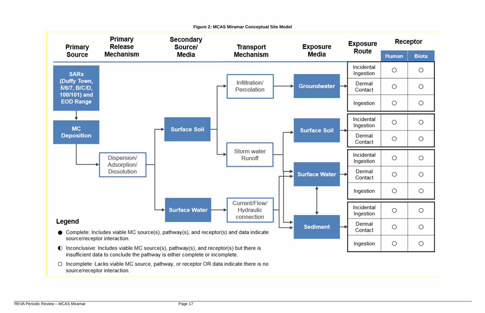
5. REVA CSM Update for MCAS Miramar The CSM for MCAS Miramar for the nine SARs and the EOD Training Range is presented as Figure 2; all pathways are incomplete. A discussion of the current MC sources, transport mechanisms, and receptors for MCAS Miramar are presented in the following subsections.
5.1 Primary Source Areas (Ranges) The SARs identified in the previous REVA studies still are operational (Arcadis, 2013 and USMC, 2017a). The REVA indicator MC for the SARs is primarily lead at the impact berms. The EOD Training Range is used for training and explosives or munitions emergency responses (USMC, 2017c). The REVA indicator MC for the EOD Training Range based on the RFMSS data is RDX. No new ranges were identified.
5.1.1 Range Layout There have been no significant changes to the SARs and their boundaries since the last assessment. Firing direction is toward the east (for Range 100) and southeast (for the eight remaining ranges). Table 1 provides information on the layout and configuration of each of the SARs at MCAS Miramar.
REVA Periodic Review – MCAS Miramar Page 6
Table 1. Small Arms Range Layout (USMC, 2017a)
Range Size
(acres) a
Firing Lines Firing Points Target Types
Duffy Town 0.31 50m 20 Carriages in butts
Range 5 0.20 3, 5, 7, 10, 15, 20, 25 yd
24 Paper on wooden targets
Range 6 0.30 3, 5, 7, 10, 15, 20, 25 yd
24 Paper on wooden targets
Range 7 0.42 3, 10, 15, 20, 25 yd
10 Paper on wooden targets
Range B 0.25 35, 40, 50 yd 25 Paper on wooden frames
Range C 0.56 3, 5, 7, 10, 15, 20, 25 yd
30 Paper on wooden frames
Range D 0.32 3, 5, 7, 10, 15, 20, 25 yd
11 Paper on wooden targets
Range 100 32.1
Known distance: 100, 200, 300, 500 yd; 40 firing lanes
Unknown distance: 8 lanes; 24 automated targets
Electronic Location of Miss and Hit targets.
Range 101 0.40 7, 15, 25, 50 yd 31 25 targets a Not including surface danger zone (SDZ) Several changes were noted in the status and configuration of the EOD Training Range since the 2008 through 2012 REVA Five-Year Review.
Inactive status: The EOD Training Range was active for the entirety of the Periodic Review period, 2013 through 2017(AECOM, 2017b). In the Five-Year Review, the EOD Training Range was inactive from 2006 until 2010. The EOD Training Range returned to active status in 2010 following completion of range modifications (including adding improvised explosive device [IED] training lanes and an increase in the net explosive weight [NEW] limit for the shot holes) and remediation at a nearby Installation Restoration Program site (Arcadis, 2013).
Expenditures: The two shot holes are located southeast of the primary range (Figure 1). o Lower Shot Hole, maximum NEW is 130 pounds in current documentation
(USMC 2017a) versus 100 pounds maximum NEW in previous review (Arcadis, 2013).
o Upper Shot Hole, maximum NEW is 5 pounds in current and previous reviews (USMC, 2017a and Arcadis, 2013).
Other expenditures: Current documentation notes that a 5-pound maximum NEW is permissible anywhere within an approximately 40-acre circle surrounding the Lower Shot Hole, as it would be encompassed within the Lower Shot Hole SDZ (USMC, 2017a). The Five-Year Review report stated that all roads present within the fenced-in EOD area
REVA Periodic Review – MCAS Miramar Page 7
could be utilized as improvised explosive device (IED) training lanes for non-fragmentary explosives (maximum NEW 1.25 pounds) (Arcadis, 2013).
Range boundary: The range boundary was not included in the GIS data provided by MCAS Miramar as an active range (USMC, 2017a and 2017d). Figure 1 shows the general location for the inactive EOD Training Range (approximately 6.5 acres). This general location is sufficient for the purposes of this assessment. However, the 2014 Certification of EOD Demolition Range notes that the EOD Training Range contains all areas within the line of the former “Atlas Missile” test compound. The previous REVA review used an estimated range boundary (Arcadis, 2013).
5.1.2 Range Management A Range Condition Assessment was completed as part of the Range Complex Management Plan at MCAS Miramar in 2013 (USMC, 2013). It summarized the amenities, types of training supported, environmental and cultural constraints, limitations and restrictions, and condition (e.g., facilities, infrastructure, safety) of each of the ranges. The facilities were found to be in adequate condition with the exception of substandard target infrastructure at Ranges B and D (inoperative turning targets and broken/rusted, respectively). No erosion damage was noted in the assessment. The EOD Training Range was noted as containing terrestrial archaeological area; and Ranges 5, 6, 7, B, C, D, 100, and 101 were noted as containing 100-year flood zone areas. Duffy Town Range was not included in the Range Condition Assessment. There is no standardized schedule for major maintenance activities at MCAS Miramar ranges; maintenance activities are conducted on an as needed basis. Installation personnel indicated that lead recovery has occurred at Ranges B, C, and D since last Five-Year Review in 2013. Additionally, lead recovery was completed at Ranges 100 and 101 in June 2017. Berm erosion at Range 101 has necessitated stabilization and slight modifications to the drainage.
5.1.3 Expenditure Data The USMC tracked munitions expenditures at each training range in RFMSS, and RFMSS expenditure data for the current reporting period (1 Jan 2012-1 May 2017) were obtained from TECOM. In order to compare munitions use during this reporting period to that of the 2008 through 2012 Five-Year Review period, annual average expenditures were calculated. To calculate the annual average number of rounds fired at each range during the current reporting period, the total number of fired rounds for each range was divided by the length of the reporting period (5.3 years) to represent an average year. The Five-Year Review Report states that RFMSS data from 2007, 2009, 2010, and 2011 were used to calculate average annual SAR expenditures. Data from 2008 were deemed unreliable and not used. RFMSS data for the Sherriff’s Department ranges were listed as combined totals from all four SARs operated by the San Diego County Sheriff’s Department each year; the Range Management Officer indicated the following allocation of expenditures: Duffy Town Range, 1%; Range 5, 9%; Range 6, 20%; and Range 7, 70%. For the EOD Training Range, expenditure data for only 2010 and 2011 were used since the range was not in use from 2006 until 2010 except for incidental emergency situations. Additionally, supplemental information was provided and used to account for expenditures that may not be captured in RFMSS (e.g., what items were found, where they were found, what remedy was applied, record of any transport/demolition materials used) (Arcadis, 2013).
5.1.4 Summary of Source Areas (Ranges) The only munitions used at MCAS Miramar are small arms at the nine SARs and demolition explosives at the EOD Training Range. The SARs configurations appear unchanged since the
REVA Periodic Review – MCAS Miramar Page 8
previous REVA review, while small modifications may have occurred at the EOD Training Range (see section 5.1.1). The SARs were grouped by geographic location and the average annual rounds for each assessment were compared to evaluate relative levels of expenditures between the current and previous five-year period. At the Duffy Town, 5, 6, 7, B, C, and D SARs, the combined total average annual expenditures doubled from slightly over one million rounds per year during the previous assessment to over two million rounds per year during the current assessment. At Ranges 100 and 101, the annual average number of rounds expended increased by approximately 200,000 rounds. The deposition of lead at the SARs constitutes a viable MC (lead) source. At the EOD Training Range, the types of items detonated for emergency operations during the current reporting period were not evaluated. The EOD training munitions (e.g., blasting caps, demolition charges, and detonating cord) expenditures (339 total) are relatively low. These levels of munitions usage indicate the EOD Training Range constitutes a minimal MC source.
5.2 Transport Mechanisms Studies have indicated that metallic lead (such as recently fired, unweathered bullets and shot) generally has low chemical reactivity, low solubility in water, and is relatively inactive in the environment under most ambient or common conditions. However, lead deposited on a range may become mobile in certain conditions (e.g., acidic soils, shallow groundwater, soils with low cation exchange capacity, high erosion rates, and close proximity to surface waters) (Clausen et al. 2007, Cao et al. 2003). Previous studies have shown that high explosive components RDX and HMX, as well as perchlorate, are mobile within the environment and have the highest potential to migrate off range (Jenkins, 2005). At the MCAS Miramar EOD Training Range, RDX is the primary concern based on the type of demolition charges and blasting caps used. MCAS Miramar has a semi-arid Mediterranean climate, with warm, dry summers and mild, wet winters (Arcadis, 2013). MCAS Miramar has received average annual precipitation of only 8.7 inches for the previous five years (2013-2017), with the average annual rainfall for the past 20 years being less than 10 inches (National Oceanic and Atmospheric Administration [NOAA], 2017). The average annual evaporation rate is 44.6-51.0 inches in Chula Vista (about 20 miles south of Miramar) (Western Region Climate Center, 2005). Surface water is not viable as a transport media in the CSM since there are no permanent surface water bodies within the range boundaries or within 3 miles downgradient of the SARs or EOD Training Range. There are no natural perennial surface water bodies at MCAS Miramar. Streams within the range boundaries and within 3 miles of the SARs and the EOD Training Range are ephemeral or intermittent, containing water only during or shortly after rainfall (Arcadis, 2013; USGS, 2015) (Figure 3). The CSM transport mechanisms for surface soil as a secondary source/media (storm water runoff and infiltration/percolation to groundwater) are discussed further in this section.
5.2.1 Storm Water Runoff While average annual rainfall is low at MCAS Miramar, erosion potential is moderate to high, and flash floods are capable of moving surface soil/sediment (USDA, 2017; Arcadis, 2013). Outfall measurements on the western portion of MCAS Miramar have indicated the pH of storm
REVA Periodic Review – MCAS Miramar Page 9
water is neutral (lower/acidic pH is more conducive to lead migration), meaning lead migration via dissolution in storm water at the SARs is likely to be limited (Arcadis, 2013).
5.2.1.1 Watersheds The nine SARs and the EOD Training Range are located in three different watersheds (Figure 3). The Duffy Town Range and Ranges 5, 6, 7, B, C, and D are in the Mission Valley-San Diego River watershed, with overall drainage toward the south-southwest (Figure 3). The installation boundary is approximately 1.5 miles away from these ranges. A major highway interchange for I-15 and California State Route 52 is located on the installation approximately 1.2 miles from Range D (Figure 1). The interchange interrupts the natural drainage between the SARs and the installation boundary. Ranges 100 and 101 are in the Rose Canyon watershed, with natural drainage flowing southwest to west (Figure 3). After passing I-15 and Kearney Villa Road into South/West Miramar (at 3.25 miles and 3.9 miles, respectively), the installation boundary is approximately 4.75 miles away. The EOD Training Range is in the Sycamore Canyon watershed, with storm water runoff generally flowing south (Figure 3). The installation boundary is approximately 2.5 miles away.
5.2.1.2 Engineering Controls at SARs During the Five-Year Review site visit, storm water engineering controls observed at the SARs were designed to redirect upland water to prevent it from flowing through the range areas, while other controls were designed to slow storm water flow from the ranges and direct it to adjacent areas within the range complex (Arcadis, 2013). The impact berms for Duffy Town Range and Ranges 5, 6, 7, B, C, and D are cut into a natural hillside. A channel is present at the base of the impact berms for the Sheriff’s Department ranges (Duffy Town Range and Ranges 5, 6, and 7) to direct storm water runoff into the gravel parking area that separates Range 7 and Range B. Drains are present at the base of the cinder block walls that separate Ranges 5, 6, and 7. These drains collect runoff from the ranges and direct it to the drainage channel west of the firing points. At Ranges B, C, and D, a continuous concrete-lined channel runs along the top of the impact berm to capture upland drainage and direct it away from the impact area on the berm. Additionally, drain lines are present in the side berms that separate Ranges B, C, and D to direct range drainage downgradient/southwest of the ranges (Figure 3) (Arcadis, 2013). At Range 100, drainage from the rear impact berm either infiltrates at the unpaved access road that runs along the foot of the berm or flows via a small drain under the target line to a vegetated swale (slows velocity of storm water and allows infiltration to retain MC on range) at the west end of the range. At the southern boundary of the range, a concrete-lined diversion catches drainage from upland reaches and redirects it west across the top of the Range 101 berm/sidewall and discharges into the main drainage west/southwest of the range. Drainage from the 100-yard berm face flows down the face toward the target line and either infiltrates or flows toward a drain located at the northwestern corner of the range adjacent to the 500-yard firing line. At Range 101, a small gated drain at the foot of the impact berm runs under the firing lines to a discharge on the western side of the range. The drain discharges through a short, thick run of cobble-sized riprap prior to flowing beyond the fence and adjacent road. A concrete-
REVA Periodic Review – MCAS Miramar Page 10
lined channel runs along the top of the impact berm to divert drainage from the upload reaches around the range (Arcadis, 2013).
5.2.2 Infiltration/Percolation to Groundwater Infiltration to groundwater and subsequent groundwater flow is likely limited by relatively high evaporation rates, the presence of a shallow hardpan layer, and the deep depth to groundwater (Arcadis, 2013). Subsurface investigations at MCAS Miramar have identified regional groundwater at depths of 160 feet to 200 feet below ground surface (bgs). Perched groundwater is often found at shallower depths (10-30 feet bgs) and discontinuous perched zones have been observed at depths greater than 100 feet bgs (Arcadis, 2013). Observations at an inactive well northwest of Ranges 100/101 (outside MCAS Miramar) indicated depth to groundwater was approximately 331 feet below ground surface (bgs) at an elevation of 731 feet (recorded 2011) (USGS, 2017). Surface soils at MCAS Miramar, and specifically the SARs and the EOD Training Range, are described as cobbly loam and gravelly loam. They are rated as well-drained; however, they typically are underlain by an impermeable hardpan at depth (Arcadis, 2013; USDA, 2017). In the alluvial soil found in the canyon bottoms, groundwater may be found close to the surface (2-10.5 feet below bgs). However, this groundwater exists only intermittently after heavy rainfall or after a series of wet years (Arcadis, 2013). Bulletin 118, which is California’s official compendium on the occurrence and nature of groundwater statewide, does not designate a groundwater basin underlying MCAS Miramar (California Department of Water Resources, 2016). A basin is defined as an, “…aquifer or stacked series of aquifers with reasonably well-defined boundaries in a lateral direction, based on features that significantly impede groundwater flow and a definable bottom…” An aquifer is defined as, “…a three-dimensional body of porous and permeable sediment or sedimentary rock that contains sufficient saturated material to yield significant quantities of groundwater to wells and springs...” (23 California Code of Regulation (CCR) Section (§) 341, 2015).
5.2.3 Summary of Transport Mechanisms The transport mechanisms of surface soil to off-range area are limited at the MCAS Miramar SARs and the EOD Training Range. While the potential for erosion of the soils are favorable for transport, the MC source areas are located approximately 1 to 5 miles from the installation boundary, surface water is intermittent, rainfall totals are relatively low, storm water pH is likely neutral and evaporation rates are relatively high. Drainage of soils are favorable for infiltration, but low rainfall, neutral storm water pH, an impermeable hardpan layer, high evaporation rates, and deep regional groundwater are not favorable to leaching of MC to groundwater. These characteristics combined with the conclusions from the Primary Source Areas (Ranges) (Section 5.1) indicate that appreciable MC are not expected to migrate off range.
5.3 Off-Range Receptors The presence of human and ecological receptors off-range is discussed below. However, based on the conclusions for the Primary Source Areas (Ranges) (Section 5.1) and Transport Mechanisms (Section 5.2), appreciable MC is not expected to migrate off-range.
5.3.1 Human Abutting the installation boundary, to the southwest of the range complex, are various businesses and commercial properties. However, a major highway interchange for I-15 and California State Route 52 is located between the SARs (i.e., Duffy Town Range and Ranges 5,
REVA Periodic Review – MCAS Miramar Page 11
6, 7, B, C, and D) and the installation boundary. The highway interchange interrupts the natural storm water flow from the SARs to the human receptors (Figure 1). A 76-acre private aggregate and asphalt plant is located just to the west of I-15 and Kearney Villa Road and is surrounded on all sides by MCAS Miramar. Storm water runoff from ranges 100 and 101 flows southwest to west passing I-15, Kearney Villa Road, and the aggregate plant, about 4.75 miles from the ranges. No extraction occurs at the site and the company now imports aggregate for the production of asphalt and concrete products at the plant. There are no non-range facilities downgradient of the EOD Training Range between the range and the installation boundary. Abutting the installation boundary, and approximately 2.5 miles from the EOD Training Range, is the Santee Lakes Recreation Preserve, which is a series of seven manmade lakes and three ponds used to collect, treat and store recycled water (treated wastewater) for use within Padre Dam Municipal Water District. The preserve offers fishing (stocked), camping, and boating as well as other general recreational activities (Santee Lakes Recreational Preserve, 2017). Based on a 1991 study, at least 19 wells used for domestic, industrial, and irrigation water supply were identified to exist within MCAS Miramar. However, based on interviews with installation personnel, none of the water used at MCAS Miramar comes from wells on the installation (Arcadis, 2013). Potable and non-potable water is supplied to MCAS Miramar by the City of San Diego, which imports an average of 85% of its water supply from the Colorado River, the State Water Projects California Aqueduct, and other distant sources (USMC, 2017e). A very limited portion of water is obtained from local groundwater wells by the City of San Diego, but sustainability projects are underway that include exploring the feasibility of obtaining additional water from local groundwater basins in the future (City of San Diego Public Utilities, 2017). Bulletin 118, which is California’s official compendium on the occurrence and nature of groundwater statewide, designates the nearest groundwater basin approximately 3 miles southeast from the EOD Training Range, just outside the installation boundary beneath Santee Lakes Recreational Preserve (California Department of Water Resources, 2016).
5.3.2 Ecological Per the Integrated Natural Resources Management Plan (INRMP) (USMC, 2011), numerous protected plant and animal species are present within MCAS Miramar. Areas on MCAS Miramar downstream and in the vicinity of the SARs are rated as very high value habitat based on a GIS-based habitat evaluation model that incorporated data collected at MCAS Miramar. Species present within East Miramar are expected to be present outside the installation as well. Federal or state-protected species listed as near or downstream from the MCAS Miramar ranges are as follows (USMC, 2011 and 2017d):
Birds: California gnatcatcher; least Bell’s vireo Plants: willowy monardella; Del Mar manzanita Invertebrates: Hermes copper butterfly (candidate)
Surface water is only present in drainage areas after infrequent rain events. Exposure of ecological receptors to surface water or sediment is limited because the water either evaporates or infiltrates into most surficial soils quickly. Ecological receptors may interact with surface soil from the impact berm area when moved by storm water; however, the distance from the source area to the nearest range boundary is over a mile. One habitat type of particular interest in and around MCAS Miramar is vernal pools. During rainy periods, ephemeral ponding may occur in hummocky areas underlain by a shallow hardpan that
REVA Periodic Review – MCAS Miramar Page 12
restricts infiltration, creating vernal pools. Water remains in the pools for several weeks to months, depending on the size of the pool, rainfall, and temperature (Arcadis, 2013). In general, vernal pools habitat at MCAS Miramar are essential to the following protected species (USMC, 2011):
Plants: San Diego button-celery; California Orcutt grass; San Diego mesa mint; spreading navarretia
Invertebrates: Riverside fairy shrimp; San Diego fairy shrimp A vernal pool resource area (coincident with several temporary wetland features) is present approximately one mile southwest (downgradient) from Range D within East Miramar near the installation boundary (USFWS, 2017; USMC, 2017d) (Figure 3). However, it is located within the range complex and is approximately 400 feet southeast and approximately 80 feet higher (upgradient) in elevation than the channel that drains storm water from the SARs. Therefore, there is no potential for off range exposure to ecological receptors present in these pools (Arcadis, 2013). The nearest vernal pool resource area to Range 100/101 is more than three miles downgradient across I-15. No vernal pool resource areas have been identified downgradient of the EOD Training Range. Exposure of ecological receptors to groundwater is unlikely due to the depth to groundwater with no known natural or manmade exposure at the surface.
5.3.3 Summary of Off-Range Receptors Human and ecological receptors are present off-range; however, the off range areas are 1.5 to 2.5 miles downgradient from the ranges. Surface water drainage from the ranges is ephemeral, and there are no permanent surface water features connecting MCAS Miramar to off-range areas. Groundwater is not known to be used on or near MCAS Miramar and all drinking water is supplied by the City of San Diego. Due to site conditions at the SARs impact berms (i.e., low rainfall and high evaporation, storm water engineering controls, neutral storm water pH, impermeable hardpan, depth to groundwater) and the limited use of the EOD Training Range, REVA indicator MC are not expected to migrate off range in appreciable quantities.
6. REVA Periodic Review Summary Based on the available data for this review, the CSM pathways for MC migration from the nine SARs and EOD Training Range at MCAS Miramar to off range receptors are incomplete. The quantity of lead generated at the SARs is relatively low, lead mining from the impact berms periodically removes the lead source, and off-range MC migration is unlikely due to minimal rainfall, absence of perennial surface water, relatively high evaporation rates, neutral storm water runoff, presence of an impermeable hardpan, and deep groundwater. While the SARs are used regularly, engineering controls at the SARs likely limit MC transport via storm water runoff from the ranges. There are limited off-range human and ecological receptors; however, they are located over 1-2 miles from the ranges, and the migration pathways to these receptors are incomplete. The EOD Training Range usage is relatively low and previous modeling has indicated MC are unlikely to migrate the 2.5-3 miles to any potential receptors in appreciable quantities (Arcadis, 2013).
The data indicate that there is no known off-range migration of MC that presents a potential unacceptable risk to human health or the environment. Therefore, no further investigation (e.g., site visit, sampling, modeling) is warranted under the REVA program at this time. All ranges will be evaluated every five years or sooner if there is a change in site conditions.
REVA Periodic Review – MCAS Miramar Page 13
7. References 23 California Code of Regulation (CCR) Section (§) 341. 2015. Definitions. Operative 16
November 2015. Accessed via https://govt.westlaw.com/calregs/ AECOM. 2017a. United States Marine Corps Range Environmental Vulnerability Assessment
Periodic Review Manual. Draft Final. June. AECOM. 2017b. Meeting Minutes for MCAS Miramar REVA Conceptual Site Model Review
(teleconference). 30 November 2017. Arcadis. 2008. Range Environmental Vulnerability Assessment Marine Corps Air Station
Miramar. September. Arcadis. 2013. Range Environmental Vulnerability Assessment 5-Year Review, Marine Corps
Air Station Miramar, California. January. Cao, X., L.Q. Ma, M. Chen, D.W. Hardison, Jr., and W.G. Harris. 2003. “Weathering of lead
bullets and their environmental effects at outdoor shooting ranges.” Journal Environ. Qual. 32:526–534.
California Department of Water Resources (CDWR). 2016. California’s Groundwater Bulletin
118, Interim Update; South Coast Hydrologic Region. Accessed via http://www.water.ca.gov/groundwater/bulletin118/index.cfm
City of San Diego Public Utilities. 2017. Annual Drinking Water Quality Report 2016. Accessed
via https://www.sandiego.gov/sites/default/files/2016_annual_drinking_water_quality_ report.pdf
Clausen, J. L., N. Korte, B. Bostick, B. Rice, M. Walsh, and A. Nelson. 2007. Environmental
assessment of lead at Camp Edwards, Massachusetts Small Arms Ranges. Hanover, NH: Cold Regions Research and Engineering Laboratory, U.S. Army Engineer Research and Development Center.
Department of Defense (DoD). 2004. DoD Directive 4715.11, “Environmental and Explosives
Safety management on Operational Ranges within the United States.” 10 May. DoD. 2005. DoD Instruction 4715.14, “Operational Range Assessments.” 30 November. Jenkins, T.F. 2005. Identity and distribution of residues of energetic compounds at military live
fire training ranges. U.S. Army Engineering Research Center. Jenkins, T.F., C. Bartolini, and T.A. Ranney. 2003. Stability of CL-20, TNAZ, HMX, RDX, NG,
and PETN in moist, unsaturated soil. ERDC/CRREL TR 03-7. Lehigh Hanson, Inc. 2017. A-1 Soils and Recycling. Accessed via
http://www.lehighhanson.com/pages/a1soils.aspx
REVA Periodic Review – MCAS Miramar Page 14
National Oceanic and Atmospheric Administration (NOAA). 2017. National Weather Service Climate Database, Monthly Total Precipitation for San Diego Miramar NAS, CA, 2012-2017. Accessed via http://www.weather.gov/sgx/.
Santee Lakes Recreation Preserve. 2017. Dynamic Vision Plan. Accessed via
http://www.santeelakes.com/ United States Department of Agriculture (USDA). 2017. Natural Resources Conservation
Service, Web Soil Survey. Accessed via https://websoilsurvey.nrcs.usda.gov/ United States Fish and Wildlife Service (USFWS). 2017. National Wetlands Inventory, National
Wetland Mapper. Accessed via https://www.fws.gov/wetlands/data/Mapper.html United States Geological Survey (USGS). 2015. Poway and La Mesa quadrangles, California
[map]. 1:24,000. USGS. 2017. National Water Information System, Groundwater Levels for USGS Site Number
325408117044701, Site Name 015S002W03D001S. Accessed via https://nwis.waterdata.usgs.gov/usa/nwis/gwlevels
United States Marine Corps (USMC). 2011. Integrated Natural Resources Management Plan for
Marine Corps Air Station Miramar, California, 2011-2015. August United States Marine Corps (USMC). 2013. Range Condition Assessments for Marine Corps Air
Station Miramar. Final. September. USMC. 2017a. Marine Corps Range Training Area Management System (MCRTAMS), USMC
Range Complexes for MCAS Miramar. Accessed via https://rtam.tecom.usmc.mil/ USMC, 2017b. About MCAS Miramar. Accessed via
http://www.miramar.marines.mil/Commands/About-MCAS-Miramar/ USMC. 2017c. Range Facility Management Support System (RFMSS) Data, 1JAN2012-
1MAY2017. Via transmittal from TECOM, 7 July 2017. USMC. 2017d. Marine Corps Installation Geospatial Information and Services (GEOFidelis)
data for MCAS Miramar. Via transmittals from installation 1 June 2017. USMC, 2017e. MCAS Miramar, Water Conservation/Management. Accessed via