Received: 17 April 2012 – Published in Nat. Hazards Earth Syst. Sci. Discuss.: –Revised: 10 December 2012 – Accepted: 7 January 2013 – Published: 8 February 2013
Abstract. Within the framework of FP7, an EU-funded Safe-Land project, a questionnaire was prepared to collect infor-mation about the use of remote sensing for landslide studyand to evaluate its actual application in landslide detection,mapping and monitoring. The questionnaire was designedusing a Google form and was disseminated among end-users and researchers involved in landslide studies in Eu-rope. In total, 49 answers from 17 different European coun-tries were collected. The outcomes showed that landslide de-tection and mapping is mainly performed with aerial pho-tos, often associated with optical and radar imagery. Con-cerning landslide monitoring, satellite radars prevail over theother types of data. Remote sensing is mainly used for de-tection/mapping and monitoring of slides, flows and lateralspreads with a preferably large scale of analysis (1: 5000–1 : 25 000). All the compilers integrate remote sensing datawith other thematic data, mainly geological maps, landslideinventory maps and DTMs and derived maps. According tothe research and working experience of the compilers, remotesensing is generally considered to have a medium effective-ness/reliability for landslide studies.
The results of the questionnaire can contribute to an over-all sketch of the use of remote sensing in current landslidestudies and show that remote sensing can be considered apowerful and well-established instrument for landslide map-ping, monitoring and hazard analysis.
1 Introduction
Landslides are one of the most serious geological haz-ards, which threaten and influence the socio-economicconditions of many countries in Europe and worldwide,
causing damages and casualties (Schuster, 1996; Schusterand Highland, 2001; Petley et al., 2005; Petley, 2012).
The observation of the Earth from space has found manyuses in the natural sciences, but it is only in the last decadesthat technological advances have also extended to landslides(Singhroy, 1995; Mantovani et al., 1996; Massonnet andFeigl, 1998; Ferretti et al., 2001; Canuti et al., 2004; Honget al., 2007; van Westen et al., 2008; Martha et al., 2010; Fer-retti et al., 2011).
Today, rapid advances are making Earth observation (EO)techniques more effective for landslide detection, mapping,monitoring and hazard analysis. Applications are originatingfrom nearly all types of sensors available today. For instance,rapid developments in this field are fostered by the very highspatial resolution obtained by optical systems (currently inthe order of tens of centimeters) and by the launching ofSAR (Synthetic Aperture Radar) sensors, purposely built forinterferometric applications with revisit times of a few days,such as TerraSAR X and COSMO-SkyMed. Moreover, in thelast years satellites have provided accurate measurements ofprecipitation such as the Tropical Rainfall Measuring Mis-sion (TRMM), which was launched in 1997. Remote rainfallmeasurements can be used to predict rainfall-induced land-slides in the framework of landslide hazard analysis (Adleret al., 2000; Hong et al., 2006; Segoni et al., 2009; Baum andGodt, 2010; Rossi et al., 2013).
Landslide detection and mapping benefit from both opti-cal and radar imagery. In the field of optical imagery a newgeneration of high-resolution satellites, such as World-View,Geo-eye, and the Pleiades constellation present resolutionsranging from 0.5 m to 2 m and offer a very powerful toolfor a quick reproduction of regional inventory maps (up toa scale of 1: 2000). Their cost/benefit ratio is relatively low,
Published by Copernicus Publications on behalf of the European Geosciences Union.
300 V. Tofani et al.: Use of remote sensing for landslide studies in Europe
considering that these satellites have a global coverage andthat the acquisition “on demand” makes the images readilyavailable (Casagli et al., 2005; Lu et al., 2011).
The analysis of optical imagery for landslide mapping canbe performed through (i) visual interpretation of single andstereoscopic images (Soeters and van Westen, 1996); (ii) im-age classification with semi-automated pixel-based methods(Borghuis et al., 2007; Marcelino et al., 2009); (iii) imageclassification with semi-automated object-oriented methods(Martha et al., 2010; Lu et al., 2011; Stumpf and Kerle,2011); (iv) change detection techniques (Nichol and Wong,2005; Weirich and Blesius, 2007; Tsai et al., 2010); and(v) correlation of optical images (Delacourt et al., 2007; Lep-rince et al., 2007; Debella-Gilo and Kaab, 2011).
Optical satellite images are also useful for indirect map-ping methods, i.e. to identify the distribution of slope insta-bility factors such as topography (Anders et al., 2009), geol-ogy and lithology (Sarkar and Kanungo, 2004; Grebby et al.,2011) and land use (Cheng et al., 2004; Casagli et al., 2005;Catani et al., 2005; Kirschbaum et al., 2009).
One of the most promising research fields related to themeasurement of ground movements derives from the devel-opment of satellite radar interferometry. In particular, theapplication of multi interferograms SAR Interferometry (A-DInSAR) techniques to the study of slow-moving landslides(velocity< 13 m month−1 according to Cruden and Varnes,1996) is a relatively new and challenging topic. A-DInSARtechniques are PSInSAR™ (Ferretti et al., 2000, 2001; Cole-santi et al., 2003), the SqeeSAR (Ferretti et al., 2011), theStanford Method for Persistent Scatterers (StaMPS) (Hooperet al., 2004, 2007), the Interferometric Point Target Analy-sis (IPTA) (Werner et al., 2003; Strozzi et al., 2006), Co-herence Pixel Technique (CPT) (Mora et al., 2003; Lanariet al., 2004), Small Baseline Subset (SBAS) (Berardino etal., 2003; Casu et al., 2006) and Stable Point Network (SPN)(Crosetto et al., 2008; Herrera et al., 2011). Scientific liter-ature reports some successful case studies dealing with thedetection and the mapping of landslide phenomena, as dis-cussed in Hilley et al. (2004); Catani et al. (2005); Strozziet al. (2005); Colesanti and Wasowski (2006); Canuti etal. (2007); Wasowski et al. (2007); Casagli et al. (2009);Cascini et al. (2009); Lu et al. (2012); Righini et al. (2012).
The monitoring of landslides by means of optical im-agery can be performed by correlating optical data. Thismethodology has been used to measure displacements notonly for landslides (Delacourt et al., 2004, 2007; Cassonet al., 2005) but also for earthquakes (Van Puymbroeck etal., 2000) and for glacier flows (Kaab, 2002; Berthier et al.,2005). The capability of DIC (Digital Image Correlation)to monitor landslide surfaces over multiple time steps hasbeen demonstrated with aerial photographs (Casson et al.,2005) and Terrestrial Optical Photogrammetry (Sturzeneg-ger and Stead, 2009; Travelletti et al., 2012). Only a fewstudies have reported the usefulness of satellite images inthis field (Delacourt et al., 2007, 2009; Leprince et al., 2008)
and exhaustive research addressing to the analysis of longeravailable very high resolution (VHR) satellite time series isstill missing.
Both differential SAR interferometry (DInSAR) andmulti-interferograms SAR interferometry (A-DInSAR) canbe used for landslide monitoring: quantitative informationon landslide activity can be acquired in the case of ex-tremely slow movements (velocity< 16 mm yr−1 accordingto Cruden and Varnes, 1996), affecting large areas withsparse vegetation (Fruneau et al., 1996; Rott and Siegel,1999; Kimura and Yamaguchi, 2000; Rizzo and Tesauro,2000).
There is an extensive bibliography of works on the use ofDInSAR and PS-InSAR for landslide monitoring (Berardinoet al., 2003; Singhroy and Molch, 2004; Strozzi et al., 2005;Meisina et al., 2007; Fornaro et al., 2009; Prati et al., 2010).In many cases the A-DInSAR data have been integratedwith in situ monitoring instrumentation (Peyret et al., 2008;Pancioli et al., 2008; Tofani et al., 2010; Strozzi et al., 2010).The joint use of satellite and ground-based data facilitatesthe geological interpretation of a landslide and allows a bet-ter understanding of landslide geometry and kinematics.
Despite the extensive bibliography available concerningremote sensing techniques and their application to land-slide mapping and monitoring, international literature stilllacks a complete framework explaining how and how muchthese techniques are operatively used nowadays in Europe byuniversities, research institutes, public agencies and privatecompanies.
With this objective the Department of Earth Sciences ofthe University of Firenze prepared a questionnaire to inves-tigate the role of remote sensing for landslide study. Thisquestionnaire has been prepared in the framework of theFP7-funded SafeLand project (2009–2012, Grant AgreementNo. 226479).
The SafeLand project, among many other issues, was ad-dressed to the development of monitoring technology, espe-cially early warning systems and remote sensing techniques.The research focuses on the detection, monitoring and ef-ficient mapping of landslides, with scales ranging from re-gional to slope. The SafeLand project was involved in thedevelopment of new procedures, techniques, hardware andsoftware for landslide study and the evaluation of existingones. In order to make an evaluation of the existing remotesensing techniques, the aim of the questionnaire was to col-lect information about the use of remote sensing in Europefor landslide study and to estimate its actual application inlandslide detection, mapping and monitoring. Some prelimi-nary results on the evaluation have been presented in Tofaniet al. (2011).
V. Tofani et al.: Use of remote sensing for landslide studies in Europe 301
2 Material and methods
The questionnaire was designed using aGoogle form (https://spreadsheets.google.com/spreadsheet/viewform?hl=enUS&formkey=dG5qUzFoRHp3WTBhbmh2cU15UWVYdUE6MA#gid=0) and was distributed in Europe amongst the commu-nity involved in landslide study. We contacted researchers,technicians, and end-users, covering as much of Europe aspossible using two main approaches: mailing lists of partici-pants to landslide-related thematic sessions of internationalcongresses, and contacts coming from different partnershipsand collaborations in some important FP7 and FP6-fundedprojects on landslides.
The questionnaire was arranged to be as comprehensibleand user-friendly as possible and the answers were automat-ically collected in a Google spreadsheet. Only a few openquestions were included and the majority of the questionswere checkboxes, in which more than one answer could bepicked. To guide the compiler throughout the questionnaire,an introductory help text was also provided. Since our mainobjective was to picture how and how much remote sensingis currently used in landslide studies, whoever filled the ques-tionnaire was asked to compile it according to his/her actualuse rather than to the one he/she would have theoreticallyused.
The questionnaire was structured into three different sec-tions: the first one related to the general information of thequestionnaire compiler (institution, location, country, con-tact person, e-mail), the second devoted to landslide detec-tion and mapping (11 questions) and the third one addressedto landslide monitoring (13 questions). An overview of thequestions is reported in Table 1. At the end of each sectionsome space was left for additional comments.
The subdivision in sections stresses the approach followedin this work: detection/mapping studies and monitoring stud-ies are considered as separate and if not explicitly stated oth-erwise, the percentages reported in this work are not calcu-lated on the total number of responses, but they are calcu-lated separately on the number of compilers that used remotesensing for detection/mapping and on those who used it formonitoring purposes.
On the whole, 49 answers were collected from 17 differ-ent European countries (Fig. 1). Even if at a first glance theanswers could seem biased towards some countries (such asItaly, 17 responses, and Spain, 6 responses), the spatial dis-tribution of the answers portrayed in Fig. 1 is consistent withthe distribution of landslides in Europe. In particular Van DenEeckhaut and Hervas (2012) report that about the 75 % ofthe European landslides registered in national and/or regionaldatabases are located in Italy, where the official Italian IFFIInventory reports over 480 000 landslides in the whole coun-try (Trigila et al., 2010). Furthermore the spatial distributionof the answers is compatible with the significance of land-slides impact on society (Guzzetti, 2000; Canuti et al., 2004;
25
1
2
Figure 1. Countries of origin of the answers to the questionnaire. 3
4
5
6
Fig. 1.Countries of origin of the answers to the questionnaire.
Guzzetti et al., 2005; Gibson et al., 2012) and the estimatedlandslide susceptibility in the various countries (Gunther etal., 2012; Van Den Eeckhaut et al., 2012). In addition, asimilar spatial distribution of the responses was obtained byDikau et al. (1996) in a questionnaire about GIS and databaseuse in landslide studies.
The answers to our questionnaire came from differentkinds of institutions: 39 % of the compilers worked at uni-versities, 24 % at research institutes, 30 % at public agencies(Geological Surveys, River Basin Authorities, etc.) and 7 %at private companies. Partners and end-users of the SafeLandproject gave a substantial contribution to the survey, provid-ing 25 % of the answers.
3 Results
The questionnaire outcomes show that in Europe, remotesensing is more frequently used for detection/mapping oflandslides than for monitoring purposes. The 83 % of thecompilers use remote sensing for both detection/mappingand monitoring, while 17 % use it only for detection andmapping purposes and no one uses it exclusively for mon-itoring.
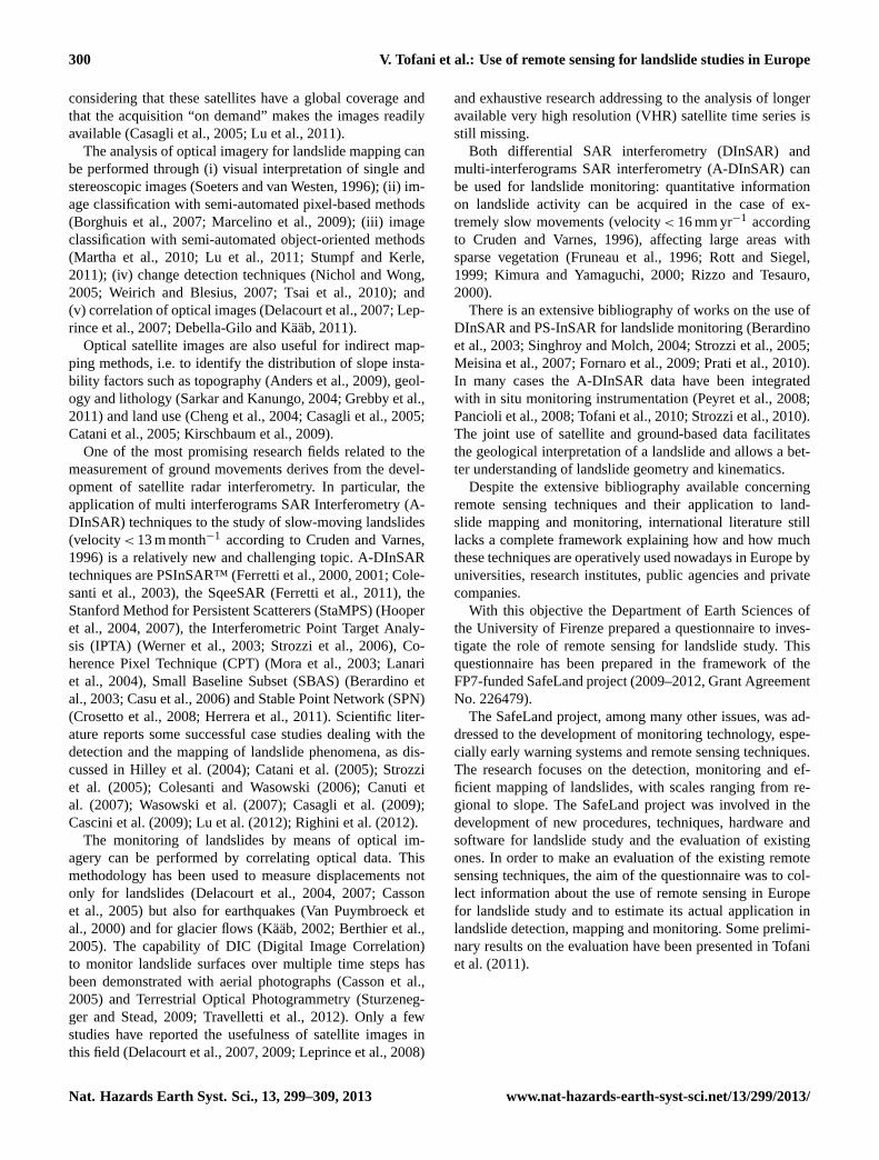
The compilers of the questionnaire reported using a va-riety of different remotely sensed data (Fig. 2). The mostcommon are aerial photos, satellite radar, satellite optical andmeteorological sensors, with percentages that considerablydiffer when the same data are used for detection/mappingor for monitoring (Fig. 2). A more restricted number of an-swers was related to other three kinds of data that are usedfor both detection/mapping and monitoring (Fig. 2): airborneand terrestrial LIDAR, airborne geophysics, and GB-InSAR.A small percentage of answers was related to the data usedonly for monitoring purposes (infrasound, ultrasonic).
10 Integration of remotely sensed data with ground-based techniques
11 Integration with other thematic data
11Effectiveness/reliability of remotely sensed data forlandslide detection and mapping
12 Duration of landslide monitoring by means ofremote sensing data and main reasons for theinterruption of monitoring, if any
13 Effectiveness/reliability of remotely sensed data forlandslide monitoring
0
10
20
30
40
50
60
70
80
Perc
enta
ge (%
)
Remote sensing data
detection and mapping
monitoring
Fig. 2.Remotely sensed data in landslide study.
Of course, all these remotely sensed data do not excludeeach other; on the contrary, most of the compilers used acombination of two or more different data. For detectionand mapping of landslides, about 75 % of the compilers usedmore than one remote sensing type of data, while the per-centage decreases to 69 % when remote sensing is used formonitoring purposes. In general the use of satellite opticaland satellite radar is associated with the use of aerial photosand the combinations of these three techniques are the mostreported.
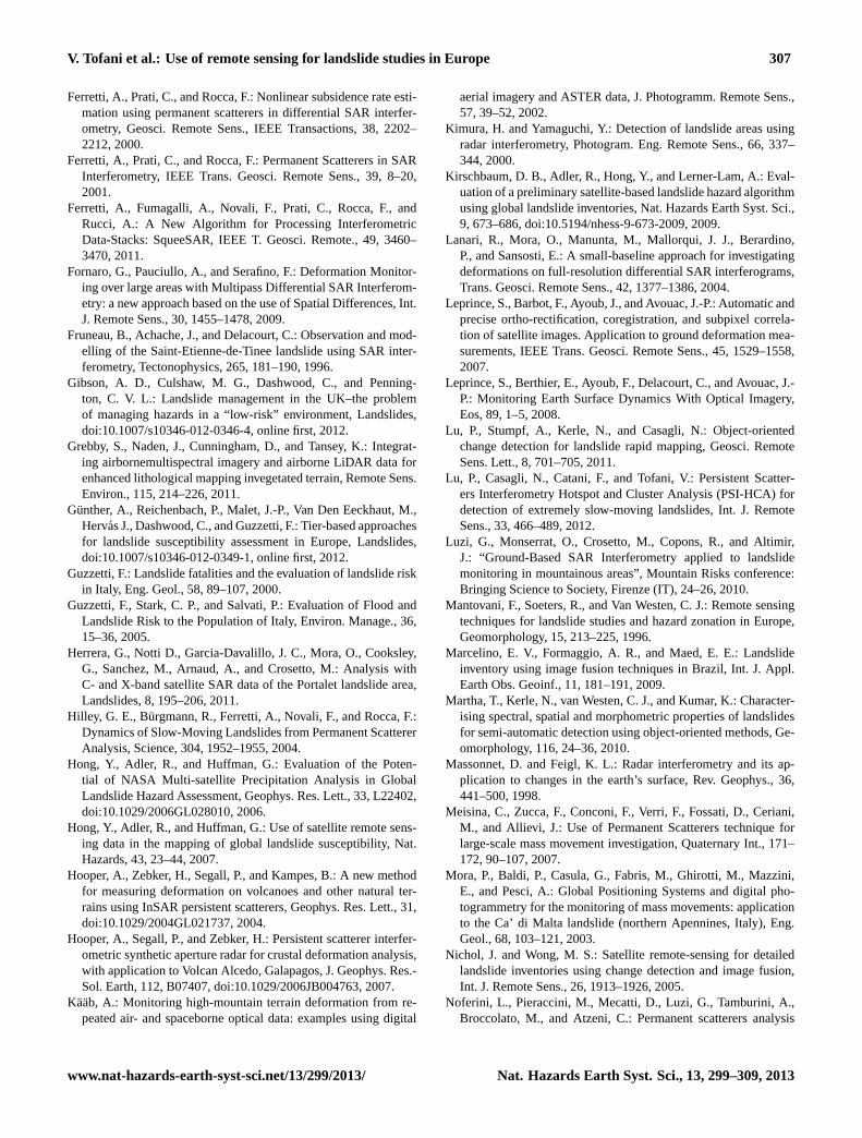
In the field of optical data imagery, the most used tech-niques are visual interpretation (87 % for detection andmapping, 79 % for monitoring), photogrammetry (47 % and
50 %) and change detection (37 % and 46 %) (Fig. 3a). Al-most each technique reports very similar percentages fordetection/mapping and for monitoring, except for imageprocessing, which is more employed in monitoring (45 %)than in detection/mapping (29 %), and for the use of spec-tral indices, which conversely are more employed in detec-tion/mapping (18 %) than in monitoring (4 %) applications.
Still considering optical data imagery for both detec-tion/mapping and monitoring, the spectral ranges most com-monly used are the visible (77 % and 72 % of answers, re-spectively) and the multispectral (60 % and 56 %). The useof NIR (Near Infrared) is also quite common as it is em-ployed by 40 % of the compilers for detection and mappingpurposes.
Concerning radar data imagery, the C band is the mostused (84 % for detection/mapping and 85 % for monitoring)since the majority of the satellite missions providing data forthe DInSAR in the last decade were operating at this band(Prati et al., 2010). The most used technique is A-DInSAR(PS-InSAR, IPTA, SBAS, etc) with a percentage of 76 % fordetection/mapping and 73 % for monitoring (Fig. 3b). A rel-evant number of compilers makes use of D-InSAR (58 %and 43 %), while SAR and GB-InSAR are less widespread(Fig. 3b).
In landslide studies, the remotely sensed data are usu-ally analyzed and visualized in conjunction with other the-matic data (Fig. 3c). Concerning detection and mapping,all the users agreed on the necessity to integrate remotely
V. Tofani et al.: Use of remote sensing for landslide studies in Europe 303
0
10
20
30
40
50
60
70
80
90
100
Perc
enta
ge (%
)
Optical techniques
0
10
20
30
40
50
60
70
80
90
100Radar techniques
detection and mappingmonitoring
detection and mappingmonitoring
a b
10
20
30
40
50
60
70
80
90
100
0
Perc
enta
ge (%
)
Thematic maps
detection and mappingmonitoring
c
Fig. 3. (a) Optical techniques employed in landslide study.(b) Radar techniques employed in landslide study.(c) Integrationof remote sensing data with other thematic data for landslide study.
sensed data with other thematic data such as DTMs and de-rived maps (87 %), geological maps (85 %), or preexistinglandslide inventory maps (83 %). The integration with otherthematic data is common for the monitoring of landslidesas well, especially with landslide inventory maps (87 %),geomorphological (81 %) and geological maps (81 %), andDTMs and derived maps (73 %) (Fig. 3c).
Remote sensing is a useful tool to also detect landslide pre-disposing factors, especially over large areas, and the 75 %of the compilers do it on a regular basis. Among them, 89 %have indicated DTM and derived parameters (e.g. slope gra-dient), 58 % lands use, 36 % hydrology and 22 % lithology.
In landslides monitoring, remote sensing is commonly in-tegrated with one or more ground-based monitoring tech-niques. Among the latter, the most used are GPS (58 %), LI-DAR TLS (48 %), inclinometers (48 %), GB-InSAR (48 %)and total stations (33 %), followed by wire extensometers(27 %), automatic inclinometers (20 %) and optical fibers(9 %), while crack-meters, geophysical methods and rod ex-tensometers are less used (< 2 % of the answers).
A crucial point in landslide studies is the identificationof appropriate technologies for each specific scientific prob-lem. Table 2 lists how remote sensing is employed accord-ing to different features of the landslides. Following theclassifications proposed by Cruden and Varnes (1996) and
by Fell et al. (2008), the given answers highlight that theuse of remote sensing is well established for slides (both ro-tational and translational) and extremely low and very slowmovements, especially in large scale applications. However,recent advances in remote sensing technology have broughtthe possibility of successful applications also for landslidesof every other typology and velocity (Table 2). Similarly, re-mote sensing is employed to investigate a large variety oflandslide parameters: some of them are very well established(e.g. geometry, activity, velocity, displacement and deforma-tion), but in a few cases new emerging remote sensing tech-niques (such as airborne geophysics) are currently appliedto investigate also other parameters (e.g. detection of pecu-liar morphological and geological structures or monitoring ofvolume changes) (Table 2).
According to the answers we gathered, the monitoring du-ration is variable from a few weeks to some decades. Thiswide range is closely related to the used technique: a fewdays or weeks for GB-InSAR, 1–2 yr with TLS, decades foroptical photos and satellite images surveys (depending on thearchives). Still, within the same techniques, some outlier val-ues of durations are reported, especially concerning recentdevelopments achieved by research institutes (e.g. discon-tinuous use of GB-InSAR covering period of some months,Noferini et al., 2005 and Luzi et al., 2010). Obviously, themonitoring duration is influenced also by the landslide type,mechanism and velocity. The main reported reasons for thepermanent interruption of monitoring are due to budget andfund problems, while temporary interruptions are mainlycaused by meteorological conditions (i.e. a snow cover forboth ground-based and airborne techniques) and hardwaremalfunctioning. Moreover, monitoring may be stopped afterseveral years of inactivity of the landslide.
4 Discussion and conclusions
The present study contributes to draw a sketch of the use ofremote sensing in current landslide studies in Europe andshows that remote sensing can be considered a powerfulinstrument for landslides mapping, monitoring and hazardanalysis. This study was mainly based on the evaluation ofthe answers to a questionnaire designed using a Google formwith multiple choices questions. The answers came from17 countries all over Europe.
The spatial distribution of the answers is consistent withthe distribution of landslides in Europe, the significance oflandslides impact on society and the estimated landslide sus-ceptibility in the various countries.
The results of the questionnaire show in general thatlandslide detection and mapping are mainly performed withaerial photos, often associated to optical and radar imagery.Concerning landslide monitoring, the satellite radar prevailson the other types of data, followed by aerial photos andmeteorological sensors. A more in depth analysis reveals that
304 V. Tofani et al.: Use of remote sensing for landslide studies in Europe
Table 2.Percentage of remote sensing employment according to different features of the case of study (landslide typology, velocity, param-eters to be investigated and scale of analysis).
those techniques are similarly ranked, also when the answersare subsampled according to the different typology of institu-tions (i.e. universities, research institutes, and end users likepublic agencies and private companies). Since a clear gap be-tween research institutes and end users is not noticeable, wemay infer that in landslide remote sensing, the research isadvancing at the same pace as its day-to-day application.
One of the features that may influence the end-users’ de-cision in selecting the technique to be used in the landslidemonitoring or detection/mapping is the costs (Stumpf et al.,2012). Obviously, other criteria being equal, the cheapesttechnology is commonly preferred. The costs of the raw in-put data are highly variable. For instance, airborne LiDARhas a high cost, since a scanning with a 0.5 points m−2 den-sity over large areas costs 100–300C km−2, which may in-crease when higher density point clouds are needed. Con-versely, in some circumstances, remotely sensed data may beeven got for free: many users reported making use of aerialphotographs because they have free access to large historicaldata, others claim to have free access to satellite radar dataprovided for free by national institutions. This can partiallyexplain why such large use is made of aerial photographs
and SAR interferometry, as reported by the survey. Anotherpossible relevant source of costs are the additional costs forprocessing, software acquisition and instruments installation,which may vary significantly even between different methodsof the same technology. The processing costs for A-DinSARtechnology, for example, can range from 2000C/100 km2
(retrospective analysis for up to 7 yr over large areas) to35 000C/100 km2 (retrospective analysis for up to 7 yr oversmall areas) (Stumpf et al., 2012). Anyhow, some space-borne technologies have reduced processing costs: for exam-ple ASTER satellites data can be processed with free soft-ware.
Both detection/mapping and monitoring of landslides areapplied to slides, flows and lateral spreads, and rarely othertypes of movements (falls, topples) are mentioned. The scaleof analysis is usually the large scale (1: 5000–1: 25 000).
All the compilers integrate remote sensing data with otherthematic data, mainly geological maps, DTMs and derivedmaps and landslide inventory maps.
On the basis of their research and working experience,the compilers evaluated the effectiveness and reliability ofremote sensing for landslide detection and mapping and for
V. Tofani et al.: Use of remote sensing for landslide studies in Europe 305
0
1
2
3
4
5
6
7
0 1 2 3 4 5 6 7 8 9 10 11
N°p
aram
eter
s
N° techniques (radar and optical)
detection andmappingmonitoring
N° cases
6
1
Fig. 4. Number of employed remote sensing techniques (radar andoptical) versus number of observed parameters.
landslide monitoring. In general, remote sensing is consid-ered to have a medium effectiveness/reliability for landslidestudies (the percentage is around 50 % for both monitoringand detection/mapping). A relevant percentage of users con-sider remote sensing a highly reliable/effective instrumentfor detection and mapping (45 %) and monitoring (36 %).Only a few compilers reported a negative opinion (6 % fordetection and mapping, 15 % for monitoring). In additionto subjective assessments, the estimated degree of effective-ness/reliability also depends on how remote sensing is used.For instance, we observed that an increase in the numberof remote sensing data type (aerial photos, satellite opti-cal, satellite radar etc.) used by the compilers, correspondsto a growth of the degree of effectiveness/reliability. Con-cerning landslide monitoring, the high degree of effective-ness/reliability increases according to the number of useddata types.
In general the number of parameters detectable throughremote sensing (both optical and radar) is linked to the num-ber of techniques employed. Figure 4 highlights that the in-crease in the number of measured parameters is related to anincrease in the number of the techniques used, both for mon-itoring and for detection/mapping. Obviously, this behaviorwould be clearer if the number of answers was higher, espe-cially because anomalous answers (as the points representing4 techniques used to monitor a single parameter) could moreclearly appear as outliers in a larger sample. Ten answers re-ported the possibility of detecting three parameters by meansof a single technique: all of them reported using radar tech-nologies and this could be considered as an indicator of abetter efficiency of radar with respect to optical techniques.
In conclusion, considering the effectiveness, reliabilityand diffusion of the various techniques, landslide detec-tion/mapping and monitoring in Europe mainly profit fromthe use of optical and radar imagery. In particular, a combi-nation of both is commonly used to obtain the best results.Moreover in the last years the research is moving toward the
set-up of semiautomatic procedures for the rapid mapping oflandslides over large areas, both for radar and optical imagery(Lu et al., 2011, 2012; Stumpf and Kerle, 2011).
Concerning landslide monitoring, the results of the ques-tionnaire stressed that the best results can be obtained com-bining remote sensing with ground based networks data andin field observations. This integration can allow defining thedeformation patterns of a landslide, its relationship with thetriggering conditions and can also provide a sound supportfor landslide modeling.
Apart from optical and radar imagery, other techniquesare less widespread and some of them are not so well estab-lished (e.g. airborne geophysics), notwithstanding their per-formances are increasing at a fast rate as scientific and tech-nological improvements are accomplished.
The application of airborne and spaceborne remote sens-ing in landslide analysis is currently providing effective re-sults in Europe. Aerial and satellite remote sensing are so farthe most widespread, but a series of different supports areemerging (e.g. drones, helicopters and boats).
The answers to the questionnaire show that remote sens-ing techniques are affected by some limitations and criticalpoints, which have to be addressed by the researchers andtechnicians to increase the effectiveness of the landslide de-tection, mapping and monitoring. The main challenge in thisregard is the improvement of the spatial resolution and theshortening of the revisiting time. The Cosmo–SkyMED (inX band) constellation, which was launched in 2007, has ashort revisiting time (12 h in the better case), such as ALOSmission (in L band) launched in 2006. Nevertheless, timeis needed before these missions will provide achievementsthat could be effectively employed in multi-temporal pro-cessing. Improvements are also expected in optical imageryfrom the development of the Pleiades program by the CNES:it is tailored on civil security applications and it consists oftwo small satellites (the first of which is currently operat-ing and has been since the end of 2011, while the secondone is scheduled for the end of 2012) with a spatial resolu-tion at nadir of 0.7 m with a daily access all over the worldand a stereoscopic acquisition capacity. The full operationaluse of all the satellite missions and the new ones already onboard is outstanding to retrieve data and information tailoredto the user’s requirements in terms of short revisiting time,high spatial resolution and cost/benefit ratio. Lastly, enhance-ments and optimizations of new software and algorithms areexpected in order to reduce computational time and to in-crease automation and robustness to avoid as much subjec-tive judgment as possible.
In conclusion, remote sensing can be considered a pow-erful and well-established instrument for landslide mapping,monitoring and hazard analysis and a wide range of avail-able techniques and source data can be approached depend-ing on the size and velocity of the investigated phenomena.This work can help in recognizing the present state of actual
306 V. Tofani et al.: Use of remote sensing for landslide studies in Europe
EO applications to landslide studies and in addressing theweakest points in future research.
Acknowledgements.The work described in this paper was sup-ported by the project SafeLand “Living with landslide risk in Eu-rope: Assessment, effects of global change, and risk managementstrategies” under Grant Agreement No. 226479 in the 7th Frame-work Programme of the European Commission. This support isgratefully acknowledged.
The authors would also like to thank all the questionnaire’scompilers for their fundamental contribution and Patrizia Musinafor the English version of the text.
Edited by: A. GuntherReviewed by: four anonymous referees
References
Adler, R. F., Huffman, G. J., Bolvin, D. T., Curtis, S., and Nelkin,E.J.: Tropical rainfall distributions determined using TRMMcombined with other satellite and rain gauge information, J.Appl. Meteor., 39, 2007–2223, 2000.
Anders, N. S., Seijmonsbergen, A. C., and Bouten, W.: Multi-scaleand object-oriented image analysis of high-resolution LiDARdata for geomorphological mapping in Alpine mountains, in: Ge-omophometry, Zurich, Switzerland, 2009.
Baum, R. L. and Godt, J. W.: Early warning of rainfall-induced shal-low landslides and debris flows in the USA, Landslides, 7, 259–272, 2010.
Berardino, P., Costantini, M., Franceschetti, G., Iodice, A., Petran-era, L., and Rizzo, V.: Use of differential SAR interferometryin monitoring and modelling large slope instability at Maratea(Basilicata, Italy), Eng. Geol., 6, 31–51, 2003.
Berthier, E., Vadon, H., Baratoux, D., Arnaud, Y., Vincent, C., Feigl,K. L., Remy, F., and Legresy, B.: Surface motion of mountainderived from satellite optical imagery, Remote Sens. Environ.,95, 14–28, 2005.
Borghuis, A. M., Chang, K., and Lee, H. Y.: Comparison betweenautomated and manual mapping of typhoon-triggered landslidesfrom SPOT-5 imagery, Int. J. Remote Sens., 28, 1843–1856,2007.
Canuti, P., Casagli, N., Ermini, L., Fanti, R., and Farina, P.: Land-slide activity as a geoindicator in Italy: significance and newperspectives from remote sensing, Environ. Geol., 45, 907–919,2004.
Canuti, P., Casagli, N., Catani, F., Falorni, G., and Farina, P.: Inte-gration of remote sensing techniques in different stages of land-slide response, in: Progress in Landslide Sciences, edited by:Sassa, K., Fukuoka, H., Wang, F., and Wang, G., Springer-Verlag,Berlin, 251–259, 2007.
Casagli, N., Fanti, R., Nocentini, M., and Righini, G.: Assessing thecapabilities of VHR satellite data for debris flow mapping in theMachu Picchu area, in: Landslides, risk analysis and sustainabledisaster management, edited by: Sassa, K., Fukuoka, H., Wang,F., and Wang, G., Proceeding of the First General Assembly ofthe International Consortium on Landslides, 2005.
Casagli, N., Tofani, V., and Adler, R.: A look from space, in: Land-slides, Disaster Risk Reduction, edited by: Sassa, K. and CanutiP., Springer, Berlin, 287–319, 2009.
Cascini, L., Fornaro, G., and Peduto, D.: Analysis at mediumscale of low-resolution DInSAR data in slow-moving landslide-affected areas, ISPRS J. Photogram. Remote Sens., 64, 598–611,doi:10.1016/j.isprsjprs.2009.05.003, 2009.
Casson, B., Delacourt, C., and Allemand, P.: Contribution of multi-temporal remote sensing images to characterize landslide slipsurface – Application to the La Clapiere landslide (France), Nat.Hazards Earth Syst. Sci., 5, 425–437,doi:10.5194/nhess-5-425-2005, 2005.
Casu, F., Manzo, M., and Lanari, R.: A quantitative assessment ofthe SBAS algorithm performance for surface deformation re-trieval from DInSAR data, Remote Sens. Environ., 102, 195–210, 2006.
Catani, F., Casagli, N., Ermini, L., Righini, G., and Menduni, G.:Landslide hazard and risk mapping at catchment scale in theArno River basin, Landslides, 2, 329–342,doi:10.1007/s10346-005-0021-0, 2005.
Cheng, K., Wei, C., and Chang, S.: Locating landslides using multi-temporal satellite images, Adv. Space Res., 33, 296–301, 2004.
Colesanti, C. and Wasowski, J.: Investigating landslides with satel-lite Synthetic Aperture Radar (SAR) interferometry, Eng. Geol.,88, 173–199, 2006.
Colesanti, C., Ferretti, A., Prati, C., and Rocca, F.: Monitoring land-slides and tectonic motions with the Permanent Scatterers tech-nique, Eng. Geol., 68, 3–14, 2003.
Crosetto, M., Biescas, E., Duro, J., Closa, J., and Arnaud A.: Gen-eration of advanced ERS and Envisat interferometric SAR prod-ucts using the stable point network technique, Photogramm. Eng.Remote. Sens., 74, 443–450, 2008.
Cruden, D. M. and Varnes, D. J.: Landslides Types and Processes,in: Landslides: Investigation and Mitigation, edited by: Turner,A. K. and Schuster, R. L., Transportation Research Board SpecialReport 247, National Academy Press, WA, 36–75, 1996.
Debella-Gilo, M. and Kaab, A.: Sub-pixel precision image match-ing for measuring surface displacements on mass movements us-ing normalized cross-correlation, Remote Sens. Environ., 115,130–142, 2011.
Delacourt, C., Alleman, P., Casson, B., and Vadon, H.: Velocity fieldof the “La Clapiere” landslide measured by the correlation ofaerial and QuickBird satellite images, Geophys. Res. Lett., 31,1561,doi:10.1029/2004GL020193, 2004.
Delacourt, C., Allemand, P., Berthier, E., Raucoules, D., Casson,B., Grandjean, P., Pambrun, C., and Varel, E.: Remote-sensingtechniques for analysing landslide kinematics: a review, B. Soc.Geol. Fr., 178, 89–100, 2007.
Delacourt, C., Raucoules, D., Mouelic, S. L., Carnec, C., Feurer,D., Allemand, P., and Cruchet, M.: Observation of a large land-slide on la Reunion island using differential SAR interferometry(JERS and Radarsat) and correlation of optical (Spot5 and aerial)images, Sensors, 9, 616–630, 2009.
Dikau, R., Cavallin, A., and Jager, S.: Databases and GIS for land-slide research in Europe, Geomorphology, 15, 227–239, 1996.
Fell, R., Corominas, J., Bonnard, C., Cascini, L., Leroi, E., andSavage, W. Z.: Guidelines for landslide susceptibility, hazardand risk zoning for land-use planning, Eng. Geol., 102, 99–111,2008.
V. Tofani et al.: Use of remote sensing for landslide studies in Europe 307
Ferretti, A., Prati, C., and Rocca, F.: Nonlinear subsidence rate esti-mation using permanent scatterers in differential SAR interfer-ometry, Geosci. Remote Sens., IEEE Transactions, 38, 2202–2212, 2000.
Ferretti, A., Prati, C., and Rocca, F.: Permanent Scatterers in SARInterferometry, IEEE Trans. Geosci. Remote Sens., 39, 8–20,2001.
Ferretti, A., Fumagalli, A., Novali, F., Prati, C., Rocca, F., andRucci, A.: A New Algorithm for Processing InterferometricData-Stacks: SqueeSAR, IEEE T. Geosci. Remote., 49, 3460–3470, 2011.
Fornaro, G., Pauciullo, A., and Serafino, F.: Deformation Monitor-ing over large areas with Multipass Differential SAR Interferom-etry: a new approach based on the use of Spatial Differences, Int.J. Remote Sens., 30, 1455–1478, 2009.
Fruneau, B., Achache, J., and Delacourt, C.: Observation and mod-elling of the Saint-Etienne-de-Tinee landslide using SAR inter-ferometry, Tectonophysics, 265, 181–190, 1996.
Gibson, A. D., Culshaw, M. G., Dashwood, C., and Penning-ton, C. V. L.: Landslide management in the UK–the problemof managing hazards in a “low-risk” environment, Landslides,doi:10.1007/s10346-012-0346-4, online first, 2012.
Grebby, S., Naden, J., Cunningham, D., and Tansey, K.: Integrat-ing airbornemultispectral imagery and airborne LiDAR data forenhanced lithological mapping invegetated terrain, Remote Sens.Environ., 115, 214–226, 2011.
Gunther, A., Reichenbach, P., Malet, J.-P., Van Den Eeckhaut, M.,Hervas J., Dashwood, C., and Guzzetti, F.: Tier-based approachesfor landslide susceptibility assessment in Europe, Landslides,doi:10.1007/s10346-012-0349-1, online first, 2012.
Guzzetti, F.: Landslide fatalities and the evaluation of landslide riskin Italy, Eng. Geol., 58, 89–107, 2000.
Guzzetti, F., Stark, C. P., and Salvati, P.: Evaluation of Flood andLandslide Risk to the Population of Italy, Environ. Manage., 36,15–36, 2005.
Herrera, G., Notti D., Garcia-Davalillo, J. C., Mora, O., Cooksley,G., Sanchez, M., Arnaud, A., and Crosetto, M.: Analysis withC- and X-band satellite SAR data of the Portalet landslide area,Landslides, 8, 195–206, 2011.
Hilley, G. E., Burgmann, R., Ferretti, A., Novali, F., and Rocca, F.:Dynamics of Slow-Moving Landslides from Permanent ScattererAnalysis, Science, 304, 1952–1955, 2004.
Hong, Y., Adler, R., and Huffman, G.: Evaluation of the Poten-tial of NASA Multi-satellite Precipitation Analysis in GlobalLandslide Hazard Assessment, Geophys. Res. Lett., 33, L22402,doi:10.1029/2006GL028010, 2006.
Hong, Y., Adler, R., and Huffman, G.: Use of satellite remote sens-ing data in the mapping of global landslide susceptibility, Nat.Hazards, 43, 23–44, 2007.
Hooper, A., Zebker, H., Segall, P., and Kampes, B.: A new methodfor measuring deformation on volcanoes and other natural ter-rains using InSAR persistent scatterers, Geophys. Res. Lett., 31,doi:10.1029/2004GL021737, 2004.
Hooper, A., Segall, P., and Zebker, H.: Persistent scatterer interfer-ometric synthetic aperture radar for crustal deformation analysis,with application to Volcan Alcedo, Galapagos, J. Geophys. Res.-Sol. Earth, 112, B07407,doi:10.1029/2006JB004763, 2007.
Kaab, A.: Monitoring high-mountain terrain deformation from re-peated air- and spaceborne optical data: examples using digital
aerial imagery and ASTER data, J. Photogramm. Remote Sens.,57, 39–52, 2002.
Kimura, H. and Yamaguchi, Y.: Detection of landslide areas usingradar interferometry, Photogram. Eng. Remote Sens., 66, 337–344, 2000.
Kirschbaum, D. B., Adler, R., Hong, Y., and Lerner-Lam, A.: Eval-uation of a preliminary satellite-based landslide hazard algorithmusing global landslide inventories, Nat. Hazards Earth Syst. Sci.,9, 673–686,doi:10.5194/nhess-9-673-2009, 2009.
Lanari, R., Mora, O., Manunta, M., Mallorqui, J. J., Berardino,P., and Sansosti, E.: A small-baseline approach for investigatingdeformations on full-resolution differential SAR interferograms,Trans. Geosci. Remote Sens., 42, 1377–1386, 2004.
Leprince, S., Barbot, F., Ayoub, J., and Avouac, J.-P.: Automatic andprecise ortho-rectification, coregistration, and subpixel correla-tion of satellite images. Application to ground deformation mea-surements, IEEE Trans. Geosci. Remote Sens., 45, 1529–1558,2007.
Leprince, S., Berthier, E., Ayoub, F., Delacourt, C., and Avouac, J.-P.: Monitoring Earth Surface Dynamics With Optical Imagery,Eos, 89, 1–5, 2008.
Lu, P., Stumpf, A., Kerle, N., and Casagli, N.: Object-orientedchange detection for landslide rapid mapping, Geosci. RemoteSens. Lett., 8, 701–705, 2011.
Lu, P., Casagli, N., Catani, F., and Tofani, V.: Persistent Scatter-ers Interferometry Hotspot and Cluster Analysis (PSI-HCA) fordetection of extremely slow-moving landslides, Int. J. RemoteSens., 33, 466–489, 2012.
Luzi, G., Monserrat, O., Crosetto, M., Copons, R., and Altimir,J.: “Ground-Based SAR Interferometry applied to landslidemonitoring in mountainous areas”, Mountain Risks conference:Bringing Science to Society, Firenze (IT), 24–26, 2010.
Mantovani, F., Soeters, R., and Van Westen, C. J.: Remote sensingtechniques for landslide studies and hazard zonation in Europe,Geomorphology, 15, 213–225, 1996.
Marcelino, E. V., Formaggio, A. R., and Maed, E. E.: Landslideinventory using image fusion techniques in Brazil, Int. J. Appl.Earth Obs. Geoinf., 11, 181–191, 2009.
Martha, T., Kerle, N., van Westen, C. J., and Kumar, K.: Character-ising spectral, spatial and morphometric properties of landslidesfor semi-automatic detection using object-oriented methods, Ge-omorphology, 116, 24–36, 2010.
Massonnet, D. and Feigl, K. L.: Radar interferometry and its ap-plication to changes in the earth’s surface, Rev. Geophys., 36,441–500, 1998.
Meisina, C., Zucca, F., Conconi, F., Verri, F., Fossati, D., Ceriani,M., and Allievi, J.: Use of Permanent Scatterers technique forlarge-scale mass movement investigation, Quaternary Int., 171–172, 90–107, 2007.
Mora, P., Baldi, P., Casula, G., Fabris, M., Ghirotti, M., Mazzini,E., and Pesci, A.: Global Positioning Systems and digital pho-togrammetry for the monitoring of mass movements: applicationto the Ca’ di Malta landslide (northern Apennines, Italy), Eng.Geol., 68, 103–121, 2003.
Nichol, J. and Wong, M. S.: Satellite remote-sensing for detailedlandslide inventories using change detection and image fusion,Int. J. Remote Sens., 26, 1913–1926, 2005.
Noferini, L., Pieraccini, M., Mecatti, D., Luzi, G., Tamburini, A.,Broccolato, M., and Atzeni, C.: Permanent scatterers analysis
308 V. Tofani et al.: Use of remote sensing for landslide studies in Europe
for atmospheric correction in Ground Based SAR Interferome-try, Trans. Geosci. Remote Sens., 43, 1459–1471, 2005.
Pancioli, V., Raetzo, H., Campolmi, T., and Casagli, N.: Ter-rafirma Landslide Services for Europe based on Space-borne In-SAR Data, in: Proceedings of the First World Landslide Forum,Tokyo, Japan, 81–84, 2008.
Petley, D.: Global patterns of loss of life from landslidesm Geology,40, 927–930, 2012.
Petley, D. N., Dunning, S. A., and Rosser N. J.: The analysis ofglobal landslide risk through the creation of a database of world-wide landslide fatalities, in: Landslide Risk Management, editedby: Hungr, O., Fell, R., Couture, R., and Eberhardt, E., Taylor &Francis Group, London, ISBN 04 1538 043 X, 2005.
Peyret, M., Djamour, Y., Rizza, M., Ritz, J. F., Hurtrez, J. E.,Goudarzi, M. A., Nankali, H., Chery, J., Le Dortz, K., and Uri, F.:Monitoring of a large slow Kahrod landslide in Alborz mounatinrange (Iran) by GPS and SAR interferometry, Eng. Geol., 100,131–141, 2008.
Prati, C., Ferretti, A., and Perissin, D.: Recent advances on surfaceground deformation measurement by means of repeated space-borne SAR observations, J Geodynam., 49, 161–170, 2010.
Rizzo, V. and Tesauro, M.: SAR interferometry and field data ofRandazzo landslide (Eastern Sicily, Italy), Phys. Chem. Earth B,25, 771–780, 2000.
Rossi, G., Catani, F., Leoni, L., Segoni, S., and Tofani, V.:HIRESSS: a physically based slope stability simulator forHPC applications, Nat. Hazards Earth Syst. Sci., 13, 151–166,doi:10.5194/nhess-13-151-2013, 2013.
Rott, H. and Siegel, A.: Analysis of mass movements inalpine terrain b, means of SAR interferometry, Geo-science and Remote Sensing Symposium, 1999. IGARSS’99 Proceedings. IEEE 1999 International, 1933–1936,doi:10.1109/IGARSS.1999.774991, 1999.
Sarkar, S. and Kanungo, D. P.: An Integrated Approach for Land-slide Susceptibility Mapping using Remote-sensing and GIS,Photogram. Eng. Remote Sens., 70, 617–625, 2004.
Schuster, R. L.: Socioeconomic significance of landslides, in: Land-slides: Investigation and Mitigation. Transportation ResearchBoard, edited by: Turner, A. K. and Schuster, R. L., Special Re-port 247, National Academy Press, WA (1995), 12–35, 1996.
Schuster, R. L. and Highland, L. M.: Socioeconomic and Environ-mental Impacts of Landslides in the Western Hemisphere: USGeological Survey Open-File Report 01-0276, 47 pp., availableat: http://pubs.usgs.gov/of/2001/ofr-01-0276/, 2001.
Segoni, S., Leoni, L., Benedetti, A. I., Catani, F., Righini, G.,Falorni, G., Gabellani, S., Rudari, R., Silvestro, F., and Reb-ora, N.: Towards a definition of a real-time forecasting networkfor rainfall induced shallow landslides, Nat. Hazards Earth Syst.Sci., 9, 2119–2133,doi:10.5194/nhess-9-2119-2009, 2009.
Singhroy, V.: SAR integrated techniques for geohazard assessment,Adv. Space Res., 15, 67–78, 1995.
Singhroy, V. and Molch, K.: Characterizing and monitoring rock-slides from SAR techniques, Adv. Space Res., 33, 290–295,2004.
Soeters, R. and Van Westen, C.: Slope instability recognition, anal-ysis and zonation, in: Landslides, investigation and mitigation,
edited by: Turner, A. K. and Schuster, R. L., Transportation Re-search Board, National Research Council, National AcademyPress, Washington, USA, 129–177, 1996.
Strozzi, T., Farina, P., Corsini, A., Ambrosi, C., Turing, M., Zil-ger, J., Wiesmann, A., Wegmuller, U., and Werner, C.: Sur-vey and monitoring of landslide displacements by means ofL-band satellite SAR interferometry, Landslides, 2, 193–201,doi:10.1007/s10346-005-0003-2, 2005.
Strozzi, T., Wegmuller, U., Keusen, H. R., Graf, K., and Wies-mann, A.: Analysis of the terrain displacement along a funicularby SAR interferometry, Trans. Geosci. Remote Sens., 3, 15–18,2006.
Strozzi, T., Delaloye, R., Kaab, A., Ambrosi, C., Perruchoud,E., and Wegmuller, U.: Combined observations of rockmass movements using satellite SAR interferometry, differ-ential GPS, airborne digital photogrammetry, and airbornephotography interpretation, J. Geophys. Res., 115, F01014,doi:10.1029/2009JF001311, 2010.
Stumpf, A. and Kerle, N.: Object-oriented mapping of landslidesusing Random Forests, Remote Sens. Environment., 115, 2564–2577, 2011.
Stumpf, A., Kerle, N., Malet, J.-P., and other SafeLand partners:Guidelines for the selection of appropriate remote sensing tech-nologies for monitoring different types of landslides. Deliver-able D4.4 of SafeLand Project, 91 pp., available at:http://www.safeland-fp7.eu, 2012.
Sturzenegger, M. and Stead, D.: Quantifying discontinuity orienta-tion and persistence on high mountain rock slopes and large land-slides using terrestrial remote sensing techniques, Natural Haz-ards and Earth System Sciences, 9, 267–287, 2009.
Tofani, V., Catani, F., Pancioli, V., Moretti, S., and Casagli, N.: In-tegration of PSI technique and conventional ground-based meth-ods for characterization and monitoring of Santo Stefano d’Avetolandslide (Central Italy), in: Mountain Risks: bringing Science toSociety, edited by: Malet, J. P., Glade, T., and Casagli, N., CergEditions, Strasbourg, 301–330, 2010.
Tofani, V., Segoni, S., Casagli, N., Catani, F., and other SafeLandpartners: Evaluation report on innovative monitoring and remotesensing methods and future technology, Deliverable 4.5 of Safe-land project, 280 pp., available at:http://www.safeland-fp7.eu.,2011.
Travelletti, J., Delacourt, C., Allemand, P., Malet, J.-P., Schmit-tbuhl, J., Toussaint, R., andBastard, M.: Correlation of multi-temporal ground-based optical images for landslide monitoring:Application, potential and limitations, J. Photogram. RemoteSens., 70, 39–55, 2012.
Trigila, A., Iadanza, C., and Spizzichino, D.: Quality assessmentof the Italian Landslide Inventory using GIS processing, Land-slides, 7, 455–470, 2010.
Tsai, F., Hwang, J.-H., Chen, L.-C., and Lin, T.-H.: Post-disasterassessment of landslides in southern Taiwan after 2009 TyphoonMorakot using remote sensing and spatial analysis, Nat. HazardsEarth Syst. Sci., 10, 2179–2190,doi:10.5194/nhess-10-2179-2010, 2010.
Van Den Eeckhaut, M. and Hervas, J.: State of the art of nationallandslide databases in Europe and their potential for assessinglandslide susceptibility, hazard and risk, Geomorphology, 139–140, 545–558, 2012.
V. Tofani et al.: Use of remote sensing for landslide studies in Europe 309
Van Den Eeckhaut, M., Hervas, J., Jaedicke, C., Malet, J.-P., Mon-tanarella, L., and Nadim, F.: Statistical modelling of Europe-widelandslide susceptibility using limited landslide inventory data,Landslides, 9, 357–369, 2012.
Van Puymbroeck, N., Michel, R., Binet, R., Avouac, J-P., andTaboury, J.: Measuring Earthquakes from Optical Satellite Im-ages, Appl. Opt., 39, 3486–3494, 2000.
van Westen, C. J., Castellanos, E., and Kuriakose, S. L.: Spatial datafor landslide susceptibility, hazard, and vulnerability assessment:An overview, Eng. Geol., 102, 112–131, 2008.
Wasowski, J., Casarano, D., Lamanna, C., Bovenga, F., Conte,D., Nutricato, R., Berardino, P., Manzo, M., Pepe, A., Zeni,G., Lanari, R., and Refice A.: A comparative analysis of DIn-SAR results achieved by the SBAS and SPINUA techniques:the Maratea valley case study, Italy. Proc. Envisat Symposium2007, Montreux, Switzerland 23–27 April 2007 (ESA SP-636,July 2007), 2007.
Weirich, F. and Blesius, L.: Comparison of satellite and air photobased landslide susceptibility maps, Geomorphology, 87, 352–364, 2007.
Werner, C., Wegmuller, U., Strozzi, T., andWiesmann, A.: Inter-ferometric point target analysis for deformation mapping, in:IGARSS 2003, Toulouse, France, 21–25 July 2003, Piscataway,NJ, 4362–4364, 2003.