Technical Report 20 August 2009 Sphagnum Bog Mapping and Recovery Plan ACT Climate Change Strategy Action Plan 2007–2011 Project Report – Action 35 Trish Macdonald Research and Planning Parks Conservation and Lands GPO Box 158 Canberra City, ACT 2601
Acknowledgements This report has been prepared by the Research and Planning Unit, Parks Conservation and Lands, Territory and Municipal Services (TAMS). Funding for the project was provided by the ACT Government through the ACT Climate Change Strategy Action Plan 2007–2011. Mapping of the peatlands of the ACT was carried out by the Department of Archaeology and Natural History, Australian National University under the direction of Professor Geoffrey Hope. Participants at the workshop ‘Climate Change and Sphagnum Bogs’ contributed significantly to this project by identify threatening processes and long-term management options. Many thanks to Dr Jennie Whinam (Biodiversity Conservation Branch, Department of Primary Industries & Water, Tasmania), Prof. Geoff Hope (Department of Archaeology & Natural History, Australian National University), Roger Good (Consultant, Good Environment Systems), Dr Sam Grover (School of Environmental and Life Sciences, Charles Darwin University), Marie Keatley (Department of Sustainability and Environment, Victoria), Charlie Pascoe, Elaine Thomas, Andrea White (Parks Victoria), Ruth Crab (Department of the Environment, Water, Heritage and the Arts), Trish Macdonald, Dr Murray Evans, Dr Margaret Kitchin, Claire Wimpenny and Greg Baines (Research and Planning, Parks Conservation and Lands, TAMS).
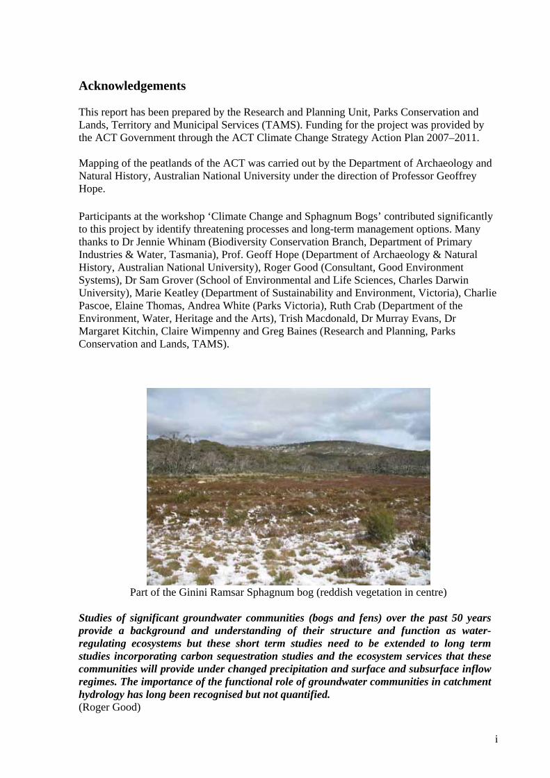
Part of the Ginini Ramsar Sphagnum bog (reddish vegetation in centre)
Studies of significant groundwater communities (bogs and fens) over the past 50 years provide a background and understanding of their structure and function as water-regulating ecosystems but these short term studies need to be extended to long term studies incorporating carbon sequestration studies and the ecosystem services that these communities will provide under changed precipitation and surface and subsurface inflow regimes. The importance of the functional role of groundwater communities in catchment hydrology has long been recognised but not quantified. (Roger Good)
ii
Contents Acknowledgements ii Executive Summary iiiiii Introduction 1 Background – What are bogs and fens? 1 History of Sphagnum bog management in the ACT 3 The map project 5 Climate change threats in the ACT 6 Climate change threats to Sphagnum bogs 6 Carbon balance of bogs and fens 10 Management recommendations 10 Recommended bog functionality monitoring program 11 References 14 Appendices a. Ecological Community descriptions for Sphagnum bog and Carex fen. 15 b. Reports published by Research and Planning, Parks Conservation and Lands. 18 Attachment The peat-forming mires of the ACT. 2009. Geoffrey Hope, Rachel Nanson and Iona Flett, Department of Archaeology and Natural History, Australian National University. Report prepared for Research and Planning, Parks Conservation and Lands, Territory and Municipal Services, ACT Government. Technical report 19.
iii
Executive Summary Sphagnum bogs and fens in the ACT are important ecological communities that provide vital ecosystem services in terms of their water filtering, groundwater storage and regulated release of water to maintain stream flow into Canberra’s domestic supply. These bog communities are also critical habitats for species such as the endangered Northern Corroboree Frog and rare Broad-toothed Rat. Alpine Sphagnum Bogs and Associated Fens are federally listed as an endangered ecological community under the Environment Protection and Biodiversity Conservation Act 1999 (EPBC Act). Climate change is likely to have a significant impact on the Sphagnum bogs and fens, threatening ecosystem resilience through drought, increased temperatures, increased incidence of wildfire and invasive species impacts. These threats may significantly impact the functioning of the bogs and result in loss of ecosystem services. To appropriately manage these ecological communities and their ecosystem services it is essential to establish the extent of the communities. This project has mapped the peatlands (bogs and fens) of the ACT. The mapping is based on orthorectified aerial photography (immediately following the 2003 fires) and satellite imagery, and provides land managers with a base line assessment of the condition of the peatlands against which future changes in their characteristics can be assessed. Rehabilitation of a number of the Sphagnum bogs burnt in 2003 has been carried out to prevent stream entrenchment and subsequent drainage and loss of these bogs. Trials to assess other bog rehabilitation techniques were also carried out. Assessment of this work has been based on vegetation recovery, with little monitoring of bog functional recovery. The importance of the functional role of groundwater communities as water-regulating ecosystems has long been recognised but not quantified. Long-term management of Sphagnum bogs needs to be based on an understanding of how the bogs are functioning and are likely to function under changes in precipitation regimes, increases in temperatures and solar radiation (UV) and changes in surface and subsurface inflow regimes. Long-term management recommendations: Ensure Sphagnum bogs remain ecologically resilient by:
i. continuing rehabilitation and monitoring of fire affected bogs to prevent stream entrenchment
ii. establishing long-term monitoring of representative Sphagnum bogs to assess changes in bog functionality due to climate change and rehabilitation actions
iii. addressing the threats of invasive species (weeds and feral animals), fire (wildfire and fuel control fires/measures) and recreational impacts.
Maintaining healthy bogs high in the catchments of the ACT is vital to the overall health of downstream aquatic and riparian ecological communities and to those human communities reliant on the water services provided by these bogs.
1
Introduction This project was initiated through the ACT Government’s Climate Change Strategy Action Plan 2007–2011, Action 35 – Sphagnum Bog Mapping and Recovery Plan. The following project outline determined the scope of the project:
The Sphagnum bogs exhibit intrinsic ecological values and are also an important part of our groundwater storage systems. A restoration program has been in place since the 2003 bush fires but further commitments are required to intensify management actions and extend the program beyond 2008. The characteristics of Sphagnum bogs and other high elevation peatlands are influenced by rainfall and temperature, and so these landscape features are potential indicators of the effects of climate change. The project will: • map Sphagnum bog and Carex fen peatlands in the ACT, against which
future changes in their characteristics of can be assessed • identify threatening processes • address long-term management options.
Project outputs were achieved in separate steps. 1. Mapping of the Sphagnum bogs and Carex fens. Mapping of the ACT peatlands was undertaken by the Australian National University, under the expertise of Professor Geoff Hope, a palaeobotanist who has specialised in mire research in the Australasian–Pacific region. Mapping was based on analysis of orthorectified aerial photography (immediately following the 2003 fires), satellite imagery and ground-truthing. 2. Identification of Threats. Identification of the processes threatening bog integrity was achieved through a workshop bringing together participants with expertise in bog research and rehabilitation from the Australian Alps bioregion and Tasmania. 3. Long-term management options. Long-term management options to ensure Sphagnum bogs remain resilient were developed during the expert workshop. The workshop recommend the following actions:
i. sustain the current rehabilitation program ii. establish a long term monitoring program to assess changes in bog function due to
climate change and rehabilitation iii. address the threats to bog integrity from feral animals, weeds and trampling (animal
and human). Background What is a bog? A bog is a complex ecological community that includes biological systems, soils, sediments and the hydrological regime. It is a three dimensional landscape structure where the actively growing vegetation is underlain by peat. Peat forms from dead plant material, both large and microscopic, accumulating in permanently waterlogged conditions where breakdown is hindered.
2
Many terms exist to describe peaty wetlands (bog, fen, mire, moor, marsh, swamp, morass). The term peat is used in this report for all organic sediments exceeding 20% dry weight of organic material and a peatland is an area in which at least 30 cm of peat has accumulated. In the ACT the peat may be up to five metres in depth. Raw peat may consist of up to 90% water, and peat deposits are important in ACT catchments because as they absorb water they moderate runoff. Water moves through peatlands as groundwater, in channels, or across the surface, with surface vegetation filtering out mineral sediment and releasing clear water. In this project a decision was taken to map all montane and subalpine peatlands in the ACT. The mapping of the ACT peatlands includes two ecological communities:
• Sphagnum Montane and Subalpine Bogs: characterised by complex vegetation, little free water surface, stagnant water (usually acidic) and low nutrition (usually depends on rainfall for minerals).
• Carex gaudichaudiana Montane and Subalpine Fens: simple vegetation, some open water fed by surface flow and moving groundwater with mineral matter often present, giving better nutrition than in Sphagnum bogs.
A full description of these ecological communities is in Appendix 1. Hope et al.(2009) have defined nine vegetation communities within these two ecological communities (see attached report, p 12). Collectively these peatlands may make up almost 6 km² of the ACT. Although the total area covered by peatland is small, water yields are significant. As an example, Snowy Flat Bog yielded 2.1 megalitres per day following 6 months of drought in 2003 (Hope et al. 2003). Protection for Sphagnum bogs in the ACT is achieved through:
• inclusion of ACT Sphagnum bogs in the Commonwealth listing of the endangered ecological community ‘Alpine Sphagnum Bogs and Associated Fens’ under the EPBC Act
• location of all Sphagnum bogs in the ACT within Namadgi National Park • the Namadgi National Park Plan of Management (currently being updated) • the Ginini Ramsar Site Plan of Management (currently being updated) • the Strategic Bushfire Management Plan, 2004 (currently being updated) and the
Bushfire Operational Plan. Growth of peat deposits A bog will build up layers of peat if the plant material build up exceeds the losses due to decay and removal. Most Australian peat deposits represent a very slight positive balance, giving rise to long-term accumulation rates in the order of 0.1–10.0 cm/century. The long-term growth rates for Sphagnum bogs in good conditions rarely exceed 5 cm/century. Clark (1980, 1983) reviewed growth rates for the Ginini Sphagnum bog over several seasons. She found that the current net growth for Ginini Bog is 3.5 cm century. Sedge (Carex) fens in extremely good conditions may accumulate 10 cm/century. At Nursery Swamp the upper 25 cm of peat has accumulated in less than 250 years. Generally decay and compression of peat in Carex fens results in a long-term accumulation rate of less than 4.0 cm/century of fibrous sedge peat. Major hindrances to growth are caused by erosion, gullying or fire. Increases in the rate of loss or decay may prevent further growth of peat by drying out the entire surface, which may then become hydrophobic (water repellent).
3
From the 1980s onwards, most research on bogs and fens in the ACT has focused on the paleo-environment and fire history. This research (based on carbon dating, fossil pollen and spores, and microscopic charcoal) suggests that most peatland development in the ACT region post-dates the last period of glaciation (26–16 000 years ago (Barrows et al. 2002)), with climatic conditions and vegetation generally resembling present day environments by 9 000–10 000 BP1. The age of ACT bogs and fens varies, with peat development initiating 14 470(±375) years ago in Nursery Swamp; 10 150(±125) BP in the Cotter Source bog; 6 300(±90) BP in Rotten Swamp; and 3 520(±80) BP in Ginini West bog (Hope et al. 2009 Attachment 1). History of Sphagnum bog management in the ACT The Sphagnum bogs of the ACT have had limited interference from human impacts when considered in the context of the bogs of the Australian Alps. The Cotter River catchment was declared a water catchment for Canberra in 1914 and all grazing was withdrawn from the catchment. The Ginini Sphagnum bog complex is recognised as a Wetland of International Importance under the Ramsar Convention on Wetlands. It is one of the deepest, largest and best preserved Sphagnum bogs on the Australian mainland (Costin 1972), at the northern biophysical limit of its habitat type, and is important in maintaining the genetic and ecological diversity of a number of endemic and restricted species. While the Brindabella and Bimberi ranges were never heavily grazed, after 1913 there continued to be movement of stock through the catchment to the snow leases in NSW and some drought relief grazing in 1920. Feral horses were common in the catchment with local landholders holding brumby runs up into the 1960s. Recognising the impacts of hard-hoved animals, feral horses were finally removed by the 1970s. Control of feral animals (particularly feral pigs, horses, rabbits, and occasionally cattle and goats) continues to ensure their impacts, particularly trampling of the fragile bog community, are minimised. Fire has been a feature of the montane and subalpine landscape in the ACT and the bogs and fens have not been immune from their impacts. Wildfires that may have had an impact on the bogs and fens in post-European times occurred in 1851, 1875, 1899, 1918, 1925, 1939, 1944, 1983 and 2003. Prior to this, major fires were less frequent and likely to have occurred approximately every 50 years (Banks 1989). Control burns in the catchment have been managed to avoid burning in the bog areas. Arboreta were established in the Brindabella ranges in the 1930s to test a range of softwoods for wood production. Escapes from arboreta have been found in some of the bogs. These exotic species have been able to establish seedlings in the more acidic bog soils and the consequence of not removing them is a significant negative impact on the way that a bog functions – with root development significantly changing the structure of the peat beds. Ginini, Snowy Flats and the Cotter Flat bog (aka Tom Gregory bog) are the bogs most impacted in this way. The 2003 fire burnt all ACT arboreta except Bendora Arboretum. The Scotch pine plantation near Pryor’s Hut did not burn and continues to provide a seedling source near the bogs of Snowy Flat.
1 BP= Before Present. The year zero for this scale is 1950, so dates need to have 60 years added to make them directly correspond to 2010.
4
Since the fires in 2003 willow wildings have been located at Ginini and Nursery Swamp. Willows are extremely invasive, well adapted to the bog conditions and will require close monitoring and immediate removal from all bogs and fens. In 1938 a trench was dug in the Ginini West side-slope bog for research by the Australian Forestry School. While further erosion of the trench did not occur the trench changed the local water regime, draining peat layers below the intact vegetation cover. The consequence of this was that in 2003 fire deeply burned the peat layers of this section of the bog down to mineral soil. This area has not recovered since the fires and rehabilitation to a functioning Sphagnum bog is unlikely to be successful. Similarly, during World War II there was mining of Sphagnum in two areas of Ginini West, for use in filters in vehicle gas producers. These areas burned in 2003 to a greater degree than surrounding areas that had not been mined, and recovery has been significantly slower in these areas. These examples indicate the fragility of bogs in response to activities that impact on their functioning. Rehabilitation of Bogs 1985–1990 Following fires in 1983 in the south of the ACT, the Sphagnum bogs at Rotten Swamp and Top Flat (on the Cotter River) began to incise: that is, a stream began to form and cut down through the peat, in the process draining and drying out the peat deposit. If left to continue, the draining of the peats would have prevented the natural recovery of the Sphagnum bogs in these areas and the ecological function (and consequent ecosystem services) of the bogs would have ceased. Active rehabilitation of these bogs was commenced in 1985–86 by damming the streams at multiple points in order to spread water out and to re-wet the peats, allowing natural regeneration of Sphagnum moss and associated species. Follow-up work indicated that while the water spreading had generally been successful stream side-cutting around the board dams indicated that an impermeable barrier may not have been the best choice. Stream cross sections were measured for several years after the boards were installed, with the intention of assessing the effectiveness of the rehabilitation. No assessment of this data has been carried out. 2003 to present Following the 2003 fires, when most of the bogs and fens in the ACT burned, these communities were assessed to see if rehabilitation was required. A number of the bogs appeared to have incipient stream entrenchment and a program of rehabilitation to spread water and prevent further entrenchment was commenced. This rehabilitation program was carried out with advice from Roger Good, formerly of NSW National Parks and Wildlife Service. He has extensive experience with rehabilitation of ground-water communities in Kosciuszko National Park. Damming of stream lines and spreading of water across peat slopes was undertaken using semi-permeable materials (hay bales and coir fibre logs that will over time become incorporated into the natural bog structure). Photo monitoring of this work has indicated that the surface vegetation is recovering and there has been reduced stream entrenchment. Monitoring to see if bog functionality is changing or improving has not been carried out, except to a minor degree at two sites. Experimental work was commenced to assess whether re-colonisation recovery of Sphagnum could be enhanced by simple interventions suitable for broad scale application. This was a cooperative project between NSW National Parks and Wildlife and ACT Parks Conservation and Lands. Experimental treatments included: fertiliser, transplanted moss, fertiliser and transplanted moss, and control (no treatment). These treatments were also tested with and
5
without horizontal shade and vertical shade cover. The experimental treatment plots were established at Rotten Swamp, Ginini Flats, Snowy Flats and Cotter Flats bogs in the ACT and at Pengilley’s Bog in Kosciuszko National Park. Data analysis from these experiments is currently being finalised. The map project Sphagnum bogs in the ACT vary in size from many hectares to smaller patches less than a hectare. Large bogs are easily visible from the air or ground, whereas small bogs are difficult to identify from the air (or from air photos) because of tree canopy cover. Prior to this project many smaller bogs had not been identified or mapped, particularly those in less accessible areas. Very limited GIS information existed on the locations of Sphagnum bogs in the ACT. From a hydrological and land-management viewpoint, information on the size and location of bogs is important if these systems are to be managed in perpetuity to continue to provide ecosystem services and habitat for rare and threatened species. The aims of the mapping project were:
• map the locations of all Sphagnum bogs
• map the boundaries of larger Sphagnum bogs
• develop a detailed GIS layer of the Sphagnum bogs of the ACT, particularly the Cotter catchment
• if feasible, map areas of live Sphagnum in the main bogs. The removal of tree canopy cover by the January 2003 wildfires provided a window of opportunity to determine the locations of smaller bogs and to map the locations and boundaries of the larger wetlands more accurately using air photo and satellite imagery. In addition, in the larger bogs (>2 ha) it was possible to map the areas of live (photosynthesising) Sphagnum as well as different types of peatland. Mapping of the live Sphagnum in the main bogs will enable assessment of the overall rate of Sphagnum recovery, as well as providing information for bog restoration efforts. Methods The mapping project was undertaken by the Australian National University, under the direction of Professor Geoffrey Hope, Department of Archaeology and Natural History, Research School of Pacific and Asian Studies. An early decision extended the mapping to include the Carex fens, so that all peatlands in Namadgi National Park were mapped. Mapping of the peatlands was based on:
• orthorectified aerial photographs of the Cotter River catchment taken in February and March 2003
• pre-fire air photos and Landsat imagery in the Gundgenby River and Naas River catchments.
Three levels of mapping were carried out:
1. Identification of the location of 166 peatlands in the ACT via visual scanning of aerial images and the use of existing point data sets (e.g. Corroboree Frog location data set).
2. Digitisation of boundaries of all peatlands greater than 0.5 ha in size (62 peatlands).
6
3. Mapping of simplified vegetation units in selected large peatlands (greater than 2 ha in size).
The peatland vegetation units are:
• live Sphagnum shrub bog • burnt Sphagnum shrub bog • sod tussock Poa grasslands • Poa-Danthonia grasslands • Restiad bog (Empodisma minus and Baloskion australe) • Carex gaudichaudiana fens.
The major peatland sites were visited to field validate and check the digital maps and to assess their condition. Peat type and depth was checked by probing and coring. Map Project outputs:
• An ESRI ArcGIS database and map layer was produced of the distribution of Sphagnum bog and Carex fen peatlands in the ACT (housed on the GIS system at Research and Planning, Parks Conservation and Lands, TAMS);
• An extended report was prepared describing the peatlands of the ACT, summarising the mapping methods and results, analysing the distribution of bogs and fens in the ACT, reviewing peat ecology and peatland histories, and estimating peat volumes and carbon storage (Attachment 1).
Climate change threats in the ACT Current climate change modelling predictions for the ACT region can be summarised as:
• higher temperatures, particularly higher minimum temperatures • increased winds in summer months • drier average seasonal conditions • increased frequency of extreme weather events • increased number of days when the fire danger index is very high or extreme • greater run-off from storms and higher evaporation from overall higher temperatures
leading to a)less water being available for consumption both by the community and the natural environment and b) a decrease in water quality
• more frequent and more severe droughts • increased atmospheric CO2.
The resilience of many ecosystems (their ability to adapt naturally to change) over the next hundred years is likely to be affected by an unprecedented combination of change in climate and associated disturbances (ACT Government 2007). A key approach in managing Sphagnum bogs and fens will be to assist in building or maintaining ecosystem resilience to withstand and adapt to these changes, keeping in mind that some amount of change in ecological communities happens all the time. Climate change threats to Sphagnum bogs Sphagnum bogs are currently at the edge of their environmental tolerances and will be increasingly stressed by climate change. It is possible that bogs and other high elevation
7
wetland areas will reduce in size due to higher temperatures and less rainfall, and may be subject to an increased fire frequency. A reduction in bog functioning will have consequent impacts on their ecosystem services. A reduction in the extent of bogs will also have an impact on species that are dependent on them for habitat, such as the endangered Northern Corroboree Frog and the rare Broad-toothed Rat. In May 2008 a workshop to investigate the direct potential impacts of climate change on Sphagnum bogs was held in Canberra. Participants with experience in Sphagnum bog research and rehabilitation across the Australian Alps region and Tasmania attended. The following list of potential climate change impacts on bogs was developed during the Climate Change and Sphagnum Bogs Workshop:
• Increases in maximum temperatures, which are a limiting factor in bog development, are likely to lead to bog decline.
• Increased temperature, precipitation and plant growth may lead to changes in the pH in bogs, with consequent changes in the ecological community.
• Environmental stress is greatest in the driest month. If Sphagnum moss (pH 4) dries out then pH levels will moderate (5.5–6) and allow other species into the bog.
• The distribution of bogs is determined by evapotranspiration in the warmest months, hence changes may lead to bog decline (Whinam and Chilcott 2002).
• Higher minimum temperatures are likely to encourage the invasion of woody species into bogs. Trees in bogs will change the vegetation structure and hydrology in the bogs.
• As temperate increases plant decomposition increases, peat accumulation decreases through oxidation of the peat and less carbon will be stored in the bogs.
• Increased plant growth will only offset decomposition where increased water is available. The predictions of a drier climate mean that any increased decomposition is unlikely to be offset by increased plant growth.
• If bogs stop accumulating peat they may begin to become significant carbon sources. To limit the negative impacts of climate change ecosystem resilience needs to be maximised. Other threats to bog integrity include pest plants and animals and fire. Predicted climate change is likely to increase these threats through a positive feedback loop. A pro-active approach in managing these threats now is vital to ensure that the natural resilience of the bogs is not undermined. The distribution and abundance of weeds and feral animals need to be monitored and control actions undertaken expediently. The Sphagnum bogs need to be protected from fire as much as possible. Weeds Under predicted climate change scenarios, as bogs dry out and pH values increase they will be more susceptible to weed invasion. There is evidence that this is already happening in the Alps generally and in some bogs in Namadgi with the invasion of pines, willows and eucalypts into bogs. Woody weed invasion has the potential to substantially alter the peatland function of the bogs, increasing the drying out of the peats. This is further exacerbated by the fact that weed invasion can be very high along drainage lines where peat has been burnt away. Weed invasion associated with climate change will be enhanced by any increase in the incidence of fire in the bogs. Burning of bog vegetation and peat changes the soil/peat pH and improves conditions for invading species.
8
Feral animals Feral animal numbers are likely to increase with the predicted climate changes, and there is increased likelihood of invasion by new feral species. Feral animals may synergistically act to increase the effects of climate change. The most obvious impacts on bogs from feral animals are the physical changes caused by trampling and compression of peats, wallowing in peats and along stream channels, and extensive rooting in the surrounding grasslands and woodlands. Feral animals may also spread weeds into bog areas. In the ACT feral horses are already having an impact on some bog areas along the Bimberi Range. Feral pigs occasionally turn over small areas of Sphagnum, but their greatest impact is the extensive rooting in grasslands and woodlands surrounding bogs throughout Namadgi NP. Occasionally feral or escaped domestic cattle have invaded bog areas with severe trampling effects. Impacts from feral horses, cattle and pigs are being addressed in the daily management of Namadgi NP. Continuity and consistency in feral animal control programs together with improving control techniques for these species will be vital in reducing the impacts of these animals in the future. Feral deer are increasing in the Cotter catchment and have the potential to severely impact bogs through trampling and wallowing. Deer numbers appear to be increasing in Namadgi NP and the presence of Sambar deer in the Cotter River catchment poses a significant threat to the resilience of the bogs. Deer impacts on bogs have been recorded in the Victorian alps. ACT Parks Conservation and Lands needs to develop plans to limit deer impacts in Sphagnum bogs. Fire ACT projections to 2050 under the high climate change scenario (Lucas et al. 2007) estimate a possible 37% increase in Forest Fire Danger Index. An increase in the likelihood of ‘extreme’ fire weather and a change in the seasonal pattern of fires will impact plant species such as Sphagnum that are killed by fire and rely on seed or spores for regeneration. Drying of bogs through increased evaporation and reduced rainfall will increase the impacts of fire on the peatland vegetation and increase the risk of peat fires. Peats exposed by burning will oxidize and release carbon stores, and an increase in the number of fires will impact species composition of peatlands. Bogs are relatively resistant to fire when they are in good condition, so preventing damage is critical to minimising the impacts of climate change. More heavily degraded sites are more impacted by fires. (e.g. grazed bogs showed a greater fire impact than ungrazed bogs in Victoria).
What will replace bogs? If fire degradation of bogs continues the ACT will end up with an increasing number of peaty sedgelands or grasslands and less Sphagnum peatlands. Grasslands will invade bogs and grow over the decomposed peat. Often where Sphagnum does persist there will be little or no peat accumulation, which means that the bog no longer functions as a peatland and its catchment values are altered. Degrading peatlands release carbon into the atmosphere.
9
Rehabilitation and fire recovery Rehabilitation of Sphagnum bogs in the Australian Alps has been ongoing since the early 1970s. The effect of much of this past bog rehabilitation has been assessed on the vegetation recovery. The vegetation appeared to recover well at many sites: however, the integration of vegetation and subsurface peat was such that it did not withstand the 2003 fires at all sites. It is likely that these sites had not fully recovered their hydrological function. This underlines the problem that restoring and maintaining functional bogs is not simple and not achievable through revegetation alone. The Sphagnum bog community in the ACT should be protected from fire for at least the next 30 years. The fact that vegetation may look healthy when the bog is not properly functioning undermines the usefulness of relying solely on satellite imagery for determining condition. It is important when monitoring bog rehabilitation programs to assess improvements in peat/hydrological function. Factors for consideration when carrying out rehabilitation in Sphagnum bogs include:
• Monitoring the vegetation can give a false impression of rehabilitation/recovery. • Rehabilitation should not focus solely on the vegetation because plants are not the sole
functional component of the bogs. • Keeping the system wet is vital. • Bogs need a depth of peat to be functional and resilient. If there is no depth to the peat
a single fire event or a change in climate may destroy it. • Natural post-fire revegetation in catchments above bogs may limit water availability to
bogs. Montane bogs may be more affected than alpine bogs by the use of water through the process of revegetation.
• Intervention for management should always take place as high in the catchment as possible because bogs are based on groundwater.
• Bog pH is usually around 4. The pH of a bog is a good indicator of its health. • Hydrologists believe that some engineering interventions to keep water in the bogs
will lead to greater erosion in the longer term and may reduce stream health. • The main aim of material selection in restoration works should be that the material
will become incorporated into the natural system. Timber, hay bales and coir logs are preferred to gabions.
• Fire management planning should target intact bogs because they will be the most resilient and have high conservation values.
• There is anecdotal evidence of differences in the recovery from fire of healthy, functioning bogs and bogs with damaged by grazing with impacts from studies done in rehabilitated and non-rehabilitated grazed bogs investigating the impacts of grazing and fire at different intensities. Analysis of existing plot-based data and aerial photograph series in the ACT might be used to assess the differences in the fire recovery of healthy verses unhealthy bogs.
• Fire suppression in bogs could be facilitated by the use of surfactants to prevent fire entering the bogs. To avoid potentially irreversible impacts it might be wise to experimentally test surfactants on a section of bog in the ACT.
Other threats Recreational trampling, infrastructure development that increases sedimentation, and drainage alteration all pose threats the integrity and resilience of bogs. These issues are addressed within the Namadgi Plan of Management and the Ginini Ramsar site Plan of Management. It
10
is vital that any actions that might lead to impacts from these activities are ameliorated so that they do not impact on Sphagnum bogs Carbon balance of bogs and fens A major concern under climate change is the acceleration of carbon release to the atmosphere. Peatlands lock up significant stores of carbon as long as they are stable or accumulating. Hope et al. (2009) have estimated the carbon stored in the ACT peatlands is 280 000 tonnes of elemental carbon with an additional 92 000 tonnes contained in the organic clays that underlie the peats. While Sphagnum peats have a higher carbon content than Carex or Empodisma peats, the sheer volume of Carex peats means that the carbon stored within the Carex fens (227 350 tonnes) is approximately six times that of the Sphagnum bogs (40 903 tonnes), with the relatively shallow Empodisma peats being a minor component (12 449 tonnes). At present it is not known whether the ACT peatlands are carbon sinks or sources, though historic data suggests that bogs, and especially fens, have good potential to act as sinks. Any degradation or loss of bogs or fens will release carbon to the atmosphere. As such, action must be focused on maintaining healthy bogs and fens in the ACT. Management recommendations The recommendations of the expert advisors at the workshop were: 1. Continue the rehabilitation and monitoring of fire affected bogs to prevent stream entrenchment and loss of bog function. Rehabilitation of Sphagnum bogs following the 2003 fires focused on water spreading and preventing stream entrenchment within bogs. This work is ongoing and Caring for Country funding continues to assist with this in 2009. Previous rehabilitation assessments suggest that full return of bog functionality may take 20–30 years. It is vital that monitoring of the water spreading, peat wetting and stream entrenchment, along with any necessary patch-up work continues into the future. The return of bog functionality is the aim of this work and therefore monitoring of the return of function should be commenced. Stream entrenchment and recovery should be monitored through stream cross sections associated with specific rehabilitation sites (e.g. dams). Return of bog functionality should be monitored by checking the soil moisture in the peat surrounding rehabilitation sites using piezometers. 2. Establish long-term monitoring in representative Sphagnum bogs to assess changes in bog functionality due to rehabilitation actions and climate change. Establish base line and long-term monitoring of the key functions of bogs (filtration, water storage, peat hydrology, water release rates, carbon sequestration) with respect to climate variables and rehabilitation activities. Once established, monitoring of bog functionality will provide feedback on the impacts of climate change and bog functional response so that actions may be implemented to reduce losses of bog ecosystem services. The recommended monitoring program from the workshop is outlined below.
11
3. Address the threats of invasive species (weeds and feral animals), fire (wildfire and fuel control fires/measures) and recreational impacts. To maximise the resilience of Sphagnum bogs it is essential that the impacts of invasive species are minimised. An integrated pest management program should be developed and implemented in and surrounding Sphagnum bog communities. The vertebrate invasive species likely to impact on bogs are feral pigs, feral horses feral deer and rabbits. These species are all present to some degree in the regions where Sphagnum bogs occur. Their impacts are both direct and indirect. Browsing by these species has been noticed in associated bog plant species. Direct impacts on bogs include wallowing, rooting and trampling both in the bog itself and in the surrounding grasslands and woodlands. The pest management program will need to include monitoring of the densities and impacts of pest species in response to control programs. A program to monitor and remove all invasive weeds in the Sphagnum bogs and their surrounds needs to be established and maintained. Recommended bog functionality monitoring program Principles for a bog monitoring program
• Monitoring needs to be systematic and repeatable. • Maintenance of long term monitoring sites is imperative. • Bog function monitoring should aim to monitor high quality bogs as a priority, as
these provide reference points. It must be accepted that we cannot monitor all bogs. If maintaining functionality is the starting point then work with healthy (functional) bogs rather than degraded ones.
• Choose reference sites that cover the range of bog types and elevations in the ACT.
• Lower technology monitoring methods are often more robust (as long as there are adequate staff to undertake the fieldwork), however physical sampling in bogs can be destructive (with people constantly trampling in to take measurements) so it can be better to use a few well placed automated stations.
• It is important to centralise datasets so that they can be found in the future.
What indicators do we need to measure so that we can detect changes in the bog so as to manage bog ecosystem services?
Prior to the establishment of monitoring, a baseline plan map and a profile (3D - surface profile with peat and moss depths) of each selected bog is required. The workshop suggested doing one or two bogs intensively and then do single profiles in other bogs.
What needs to be measured is how much water is falling on a bog and how the bog responds (i.e. x litres into system, y litres out and what is the delay). Measurements should include rainfall, water table depth (critical), soil moisture, wetted boundary, groundwater flow, peat cores, peat accumulation/degradation, water chemistry (chemistry is related to plant function and bog function), bog pH (a good indicator of health and a good feature to test because climatic change should lead to less acidity) and quadrat based vegetation surveys. In gathering appropriate weather information (rain gauges, automated weather stations and a UV gauge) it is vital that the data comes directly from the bog being monitored, not from the nearest weather station.
12
Note: There has only been one quantifiable study of a bog (Dane Wimbush’s study at Dane’s Bog, Kosciuszko National Park (Wimbush 1970)). Monitoring Bog Functionality
‘Think minimal, establish simple techniques first and expand from there.’
• Essential measurements:
i. Inflow (rain gauge and weather station) and outflow (V-notch weirs). ii. Watertable depth measured via automated piezometers linked to weather
stations in reference areas, and soil moisture probes. Assess differential hydrology (horizontal and vertical flows) to see if these change.
iii. Surface profile (including channel form, pools, peat and moss depth) Map using stainless steel poles/probes/pins across reference bogs. Initial coring is required to obtain the peat profile across the bog.
iv. Mapping the wetted boundary using differential GPS, soil probes and air photos.
v. Floristics (weeds, vegetation composition and species changes). This will require permanent plots with long-term data to see change over time. Plots should be measured at least annually for the first three years after an event like the 2003 fires, but it is desirable to do it annually for five years, then every two years up to 10 years after event.
vi. Fire impacts. Map changes in extent/distribution, fire intensity and fire history. vii. Feral animal impacts. Consider exclosures to monitor impacts.
• Desirable measurements:
i. Water chemistry. pH provides an indication of bog condition, as do carbonates, nitrites, total dissolved oxygen and turbidity (suspended and dissolved organic matter in water).
ii. Carbon balance The loss-on-ignition technique measures organic material in peat and is a good indicator of change in the system.
Previous reports/references do not refer to the effects on bogs of solar factors such as radiation, UV and day length. For example, how do plant communities respond to an increase in UV light? (We may get a partial answer from shading experiments of Whinam et al, in press). These impacts need to be assessed and monitored. Altered levels of carbon dioxide also need to be considered as this may result in an increase in woody weeds. Methods for Monitoring
Note: not all methods are relevant at all sites. The aim is to understand the basic functioning of the system before looking at impacts. It is not necessary to monitor all of the parameters in the initial stages. Monitoring methods include:
• In flow/out flow/watertable
i. Weather station ii. V-notch weir
iii. Piezometers (automated and manual)
13
iv. Moisture probe • Surface Profile
v. Pins (stainless steel stakes) vi. Initial coring
vii. Peat probe viii. Air photo’s (channels and pools)
ix. LIDAR (DEM, >$10,000) • Wetted Boundaries
x. Differential GPS xi. Soil moisture probe
xii. API (special large scale runs) • Floristics
xiii. Permanent plots xiv. Species richness and cover (1yr for 3-5yrs, every second year for
another 5 yrs) xv. Veg type boundaries
xvi. Exclusion plots to measure damage • Soil water and chemistry
xvii. pH, turbidity, suspended and dissolved organic matter xviii. organic content (soil, loss on ignition)
• Fauna i. Assess potential impact and habitat by mapping changes in vegetation
boundaries (via aerial photos) approx every 5 years. Carbon Balance
Carbon balance information is very important and should be a priority project that runs parallel to the monitoring project. The key question here is ‘are the bogs respiring (releasing carbon) or aspiring (locking in carbon)?’ Answers to this question will let you know if the peat is accumulating or declining and provide information on the health of individual bogs. Carbon balance may change with wet/dry seasons and is a monitoring technique rather than a baseline assessment. Carbon balance measures are expensive and may need to be done as a specific project. (Potential as an Australian Alps national parks project)
14
References ACT Government 2007 Weathering the Change: The ACT Climate Change Strategy 2007–
2025. Territory and Municipal Services, Canberra. ACT Government 2004 Strategic Bushfire Management Plan for the ACT. Australian
Capital Territory Emergency Services Authority, Canberra. Barrows, T.T., Stone, J.O., Fifield, L.K. and Creswell, R.G. 2002 The timing of the Last
Glacial Maximum in Australia,. Quaternary Science Reviews 21:159–173. Banks, J.C.J. 1989 A history of forest fire in the Australian Alps. in R. Good (Ed) The
Scientific significance of the Australian Alps. Australian Alps Liaison Committee and the Academy of Science, Canberra.
Clark, R.L. 1980 Sphagnum growth on Ginini Flats, ACT. Unpubl. Report to NSW National
Parks and Wildlife Service. Clark, R.L. 1983 Fire History from Fossil Charcoal in Lake and Swamp Sediments. PhD
thesis. Australian National University, Canberra. Costin A.B. 1972 Carbon-14 dates from the Snowy Mountains Area, Southeastern Australia,
and their interpretation, Quaternary Research 2: 579–590 Hope G., Wade A. and Whinam J. 2003 A report on the state of the mountain mires of the
Australian Capital Territory after the fires 14–22 January 2003. Report to the ACT Recovery Group: Natural Resources and Wildlife Programs, Environment ACT, Canberra.
Hope G., Nanson, R. and Flett,I. 2009 Technical Report 19. The peat forming mires of the Australian Capital Territory. Territory and Municipal Services, Canberra. Lucas, C., Hennessy, K., Mills, G. and Bathols, J. 2007 Bushfire weather in southeast
Australia: recent trends and projects climate change impacts. Consultancy report prepared for the Climate Institute of Australia, Bushfire Cooperative Research Centre, Melbourne.
Wimbush D.J. 1970 Hydrological studies on Sphagnum bogs in the Snowy Mountains. MSc
thesis, University of NSW, Sydney. Whinam, J. and Chilcott, N. 2002 Floristic description and environmental relationships of
Sphagnum communities in NSW and the ACT and their conservation management, Cunninghamia 7(3): 463–500.
Whinam, J., Hope, G.S., Good, R. and Wright, G. (in press) Five years of post-fire
monitoring of the recovery of Sphagnum bogs in the ACT and NSW, Environmental Management and Restoration.
15
Appendix 1 ACT Ecological Community Descriptions a) Sphagnum cristatum Montane and Subalpine Bogs
(Sphagnum Montane and Subalpine Bogs)
Conservation Status The community is identified as requiring conservation action due to the impact of the wildfires in 2003 (Sharp et al. 2007). Community vegetation description Sphagnum cristatum Montane and Subalpine Bogs in the ACT are characterised by complex vegetation dominated by Sphagnum cristatum moss with little free water surface. The water retained within the bog, only slowly percolating through it, is acidic with extremely low plant nutrient levels usually depending on rainfall. In high altitude areas (>1400 m) S. cristatum forms hummocks up to 60 cm deep, overlying peats and peaty silts of about 50–140 cm (up to 300 cm). Bogs are often overtopped by epacrid shrubs such as Richea continentis, Epacris breviflora and myrtaceous Baeckea gunnii and Callistemon sieberi. At lower altitudes Richea is absent but Epacris paludosa is common and Bacekea utilis is also present. Empodisma minor is always present together with other sedges and grasses. The bogs (mires) are sometimes transitional to well drained areas of sod-tussock formation (grass bog) and Phragmites australis is occasionally the dominant macrophyte in low altitude Sphagnum bogs. Peat formation may impede drainage and cause flooded areas along streams or within the bog. Locally, small depressions or basins, sometimes of human origin, may develop which are probably near-permanent as they support a diverse flora of aquatics, including Utricularia dichotoma, Myriophyllum amphibium, Nymphoides montana, Elaeocharis acuta, Juncus sp., Hydrocotyle sp. and Limosella australis (Hope et al. 2003). Physical environment Bogs are widespread in the high mountains of the ACT but are topographically restricted to the heads of streams and along stream floodplains where precipitation is greater than 850 mm with mean annual temperatures below 12°C. Sphagnum bogs are associated with more variable regimes of inundation and more acidic waters than in fens (Costin 1954). Bog soils generally have less phosphorous, nitrogen and potassium than those of fens, although the two types of wetlands are often juxtaposed. Where Sphagnum grows prolifically it forms many layers of spongy substrate (capable of retaining large amounts of moisture), which decompose slowly into peat. Over time these sites may develop into raised bogs. The diversity of sedges and shrubs able to coexist among the Sphagnum increases as the soils become more aerated, with shrubs being more abundant in bogs on slopes. Such peaty acid soils, although saturated, are somewhat better drained than valley floor bogs.
16
Associations Carex gaudichaudiana – Sphagnum cymbifolium Valley Bog Callistemon sieberi – Sphagnum cymbifolium Raised Bog; Epacris paludosa – S. cymbifolium Raised Bog; Richea continentis – S. cymbifolium Raised Bog; Restio australis – S. cymbifolium Raised Bog; Restio(Baloskion) australis – Carex gaudichaudiana Raised Bog; Carex gaudichaudiana Raised Bog Epacris paludosa – Richea continentis wet heath – bog (Upper Cotter Valley, 1500–1850 m altitude) Epacris breviflora – Baeckea utilis wet heath (Cotter flats at 1030 m, and 1200–1400 m). Sphagnum cristatum – Empodisma minus Sphagnum cristatum – Epacris microphylla Sphagnum cristatum – Richea continentis Sphagnum cristatum – Baeckea gunnii Sphagnum cristatum –Hakea micrantha Characteristic shrubs Epacris breviflora, E. paludosa, Richea continentis, Baeckia gunnii, B. utilis, Callistemon sieberi. Characteristic groundcover Empodisma minor, Sphagnum cristatum, Baloskion australis (syn. Restio australis) Associated flora and fauna Northern Corroboree Frog (Pseudophryne pengelleyi) Endangered (NCA, EPBC) Lathams Snipe (Gallinago hardwickii), Broad-toothed Rat (Mastycomys fuscus), Metallic Bog Cockroach (Polzostera viridisma), Alpine Water Skink (Eulamprus kosciuskoi) and the Bog Dwelling Crayfish (Euastacus reiki). Representative site locations Ginini Flats (a listed Ramsar site, Ramsar 1971), Snowy Flats, Rotten Swamp, Cotter Source Bog, Murrays Gap, Cotter Flats (Near Cotter Hut). Pre-European extent The pre-European extent is similar to present distribution. Since the fire event of 2003, it is in recovery throughout its range. Current extent Sphagnum bogs cover 166.6 ha of the ACT (see attached ancillary report, Hope et al. 2009). Percentage remaining of community Greater than 30%. Percentage of community in conservation reserves The community in the ACT is entirely within Namadgi National Park.
17
Condition of the community Bogs (mires) in the ACT were affected by grazing to a minor extent and by increased fire frequency, prior to protection provided under the Cotter River Ordinance 1914. In 1983, fire burned significant bog areas in the southern portion of the ACT. Following this event, stream entrenchment in the bog areas became evident. Subsequent rehabilitation through water spreading techniques appeared to halt this process and the bog community appeared to redevelop. In 2003, fires burned almost all the Sphagnum Montane Subalpine Bogs in the ACT, with the burnt area in individual bogs varying from 55 –100%. The response following these fires has been variable, reflecting the different fire severities and pre-existing and continuing drought effects. Recovery of the bogs is likely to be slow, and it is also likely that there will be a reduction in the extent of this community as a result. Assessment, recovery, rehabilitation, and research programs are being undertaken in these communities in an effort to assist bog recovery. Threats or threatening processes affecting the community The very delicate and wet environments of the bogs are particularly susceptible to trampling by feral animals, especially horses and pigs. These animals uproot plants and wallow in the mud, create open spaces allowing weed invasion, form open ponds and free-draining channels. Humans activities such as fire control may alter drainage patterns, and consequently, vegetation composition including the introduction of weeds. Trampling by people remains evident for long periods especially in Sphagnum hummocks. Bogs are also vulnerable to the effects of road construction and drainage alteration, particularly in the Cotter Catchment and along the Mt Franklin Road. The most serious potential impact is increased siltation due to erosion of the road surfaces and associated areas.. The montane and subalpine bogs are likely to be affected by climate change (Pickering et al. 2004). Fire is also a significant threat to this community, particularly if the frequencyof fires and the difficulty of fire management both increase due to climate change. Fire regime Studies of burnt bogs (Wimbush & Costin 1983) have indicated that bog systems that do begin to recover following fire will take a minimum of twenty years to fully respond in the absence of further degradation. Recommendations The following actions are recommended in order to conserve the Sphagnum cristatum Montane and Subalpine Bogs of the ACT:
• Protected from fire for at least the next 30 years • Continue to support rehabilitation following 2003 fires • Assess recovery through long-term monitoring • Survey and assess condition of bog communities • Document the botanical composition of suitable bogs as standards for
definition of the ACT bog community, selecting a range of altitude and drainage variabilities.
18
References Costin A. 1954 A Study of the Ecosystems of the Monaro Region of New South Wales, with special reference to soil erosion. Soil Conservation Service of NSW, Government Printer, Sydney.
Hope G., Wade A. & Whinam J. 2003 A report on the state of the mountain mires of the Australian Capital Territory after the fires 14–22 January 2003. Report to the ACT Recovery Group: Natural Resources and Wildlife Programs, Environment ACT.
Hope, G., Nanson, R. and Flett, I. 2009 The peat-forming mires of the Australian Capital Territory. Ancillary Report to: Technical Report 19. Sphagnum Bog Mapping and Recovery Plan. ACT Climate Change Strategy Action Plan 2007–2011, Action 35 Project Report. Department of Territory and Municipal Services, Canberra. Pickering C. Good R. and Green K. 2004 Potential Effects of Global Warming on the Biota of the Australian Alps. Report to the Australian Greenhouse Office, Canberra. Sharp S., Macdonald T., Kitchin M., Dunford M. 2007 Setting Conservation Targets for Vegetation Communities in the ACT. Report to the ACT Natural Resource Management Council, June 2007.
Wimbush D. J. & Costin A. B. 1983 Trends in drainage characteristics in the sub-alpine zone at Kosciusko. Proceedings of the Ecological Society of Australia 12: 193–221.
b) Carex gaudichaudiana Montane and Subalpine Fen
(Carex Montane and Subalpine Fen)
Conservation status Adequately conserved in the ACT (Sharp et al. 2007). Community vegetation description Carex gaudichaudiana Montane and Subalpine Fen is a simple wetland community with dense swards of soft-leafed tussock sedges and grasses that have some semi-aquatic species but few shrubs. The widespread sedge Carex gaudichaudiana usually dominates over other species such as Ranunculus species. Physical environment Fens in the ACT are local occurrences on almost level, broad valley flats with permanently wet soils with impeded drainage. They occur on the wettest sites where water remains for extended periods, with some open water, producing peaty soils that are moderately acidic or neutral in pH. Groundwater is moving, though streams lack channels and flood frequently. Mineral matter is often present, giving higher nutrient levels. Fens may colonise pond areas within bogs.
Associations Fen: Carex gaudichaudiana, Scirus polystachyus Creeklines in Fen: Carex gaudichaudiana, Myostis caespitose Creekline Swamps: Carex spp., Juncus spp., Ranunculus pimpinellifolius Characteristic species Carex gaudichaudiana, Juncus breviculmis, Hydrocotyle spp., Ranunculus rivularis, R. australis, Asperula gunni, Neopaxia australasica, with minor species Ranunculus inundatus, Schoenoplectus validus, Carex appressa, Myostasis discolor, Phragmites australis
19
Representative site locations Nursery Swamp fen, Upper Nass fen, Gudgenby (Bogong Creek) and the Orroral River fen. Nursery Swamp and the Upper Naas fen are both identified as nationally important wetlands (Environment Australia 2001)).
Pre-European extent The pre-European extent is similar to present distribution.
Current extent Carex fens cover 297.8 ha of the ACT (see attached ancillary report, Hope et al. 2009). Proportion reserved in ACT All of the community in the ACT is reserved as it is entirely within Namadgi National Park.
Condition of the community The montane fens may have had alterations or impacts upon them resulting from the pastoral period.
Despite the majority of this community being burnt in the 2003 fires, the Carex fens at Nursery Swamp, Rendezvous Creek, Hospital Creek, Gudgenby (Bogong) Creek and Orroral Valley are making a rapid recovery in response to their generally moist surfaces that has helped the sedge bases to survive. They regained 60–85% of their former cover after one year through resprouting of Carex. The one exception is the degraded Carex fen at Sheep Station Creek, where fire burned down into the peats 20 to 40 cm, so that no regeneration has occurred (Hope et al. 2003).
Threats or threatening processes The main threats are severe drought and wildfire. If a fen has dried out (e.g. Sheep station Creek fen) and burns during a wild fire the potential for a peat fire is very high. Such fires are extremely difficult to extinguish and are likely to lead to collapse and erosion of the peat beds, with no regeneration of the fen. Fire in the catchments of these fens is likely to have an impact through sedimentation and nutrient flushes.
Fens are vulnerable to impact from fire trail construction or drainage alteration.
References Environment Australia 2001 A directory of Important Wetlands in Australia. Third edition. Environment Australia, Canberra.
Helman C. E. & Gilmour P.M. 1985 Treeless Vegetation Above 1000 metres Altitude in the ACT. A report to the Conservation Council of the Southeast Region and Canberra, Canberra.
Hope G., Wade A. & Whinam J. 2003 A report on the state of the mountain mires of the Australian Capital Territory after the fires 14–22 January 2003. Report to the ACT Recovery Group: Natural Resources and Wildlife Programs, Environment ACT.
Hope, G., Nanson, R. and Flett, I. 2009 The peat-forming mires of the Australian Capital Territory. Ancillary Report to: Technical Report 19. Sphagnum Bog Mapping and Recovery Plan. ACT Climate Change Strategy Action Plan 2007–2011, Action 35 Project Report. Department of Territory and Municipal Services, Canberra.
Ingwersen F. 2001 Sundry nameless ranges: the landscape ecology of the Naas–Gudgenby catchment. PhD Thesis, Australian National University, Canberra.
Sharp S., Macdonald T., Kitchin M., Dunford M. 2007 Setting Conservation Targets for Vegetation Communities in the ACT. Report to the Natural Resource Management Council, June 2007.
20
Appendix 2 Reports published by Research and Planning, Parks Conservation and Lands.TECHNICAL REPORT SERIES
Lintermans, M. 1993. The vertebrate fauna of the Gudgenby region, Australian Capital Territory. Technical Report 1.
Ormay, P. and Ingwersen, F. 1993. Management of Xanthorrhea australis in Tidbinbilla Nature Reserve. Technical Report 2.
Osborne, W. S. and McKergow, F. V. C. 1993. Distribution, population density and habit
at of the pink-tailed legless lizard Aprasia parapulchella in Canberra Nature Park. Technical Report 3.
Lintermans, M. 1993. Oriental weatherloach Misgurnus anguillicaudatus in the Cotter River: A new population in the Canberra region. Technical Report 4.
Rauhala, M. 1993. Distribution and habitat of the nobby dragon Amphibolurus nobbi in the Australian Capital Territory. Technical Report 5.
Rauhala, M. 1993. The reptile, amphibian and mammal fauna of the Stony Creek Nature Reserve, Australian Capital Territory. Technical Report 6.
Rutzou, T. V., Rauhala, M. A. and Ormay, P. I. 1994. The fish fauna of the Tidbinbilla River catchment. Technical Report 7.
Sharp, S. 1994. Lowland native grasslands in the ACT and surrounding region: A review and research strategy for a recovery plan. Technical Report 8.
Driscoll, D.A. 1994. Invertebrates of lowland native grasslands in the Australian Capital Territory: Conservation and research strategies for a recovery plan. Technical Report 9.
Osborne, W.S. and Jones S. R. 1995. Recovery plan for the pink-tailed worm lizard (Aprasia parapulchella). Technical Report 10.
Rauhala, M. A. 1995. The reptile, amphibian and mammal fauna of the Gigerline Nature Reserve, Australian Capital Territory. Technical Report 11.
Coulson, G. 1995. Management directions for the striped legless lizard (Delma impar) in the Australian Capital Territory. Technical Report 12.
Ormay, P. 1996. Status of the brush-tailed rock wallaby Petrogale penicillata in the Australian Capital Territory. Technical Report 13.
Rauhala, M. A. 1997. Frog fauna of the Australian Capital Territory: A review. Technical Report 14.
Lintermans, M. 2000. The Status of Fish in the Australian Capital Territory: A Review of Current Knowledge and Management Requirements. Technical Report 15
Lintermans, M. (in prep.) Partial recovery of the Murray River Crayfish Euastacus armatus in the Australian Capital Territory after the implementation of protective management measures. Technical Report 16. Carey, A, Evans, M., Hann,P., Lintermans, M., Macdonald, T., Ormay, P., Sharp, S., Shorthouse, D., and Webb, N. 20003. Wildfires in the ACT 2003: Report on Initial Impacts on Natural Ecosystems. Technical Report 17. Lunt, I.D. 2005. Effects of Stock Grazing on Biodiversity Values in Temperate Native Grasslands and Grassy Woodlands in SE Australia: A Literature Review. Environment ACT, Canberra. Technical Report 18. Hope, G., Nanson, R. and Flett, I. 2009 The peat-forming mires of the Australian Capital Territory. Department of Territory and Municipal Services, Canberra. Technical Report 19. RESEARCH REPORT SERIES Kukolic, K. 1990. A survey of the vertebrate fauna of Mt Ainslie, Mt Majura and Black Mountain, 1975–76. Research Report 1.
Lintermans, M., Rutzou, T. and Kukolic, K. 1990. The status, distribution and possible impacts of the oriental weatherloach Misgurnus anguillicaudatus in the Ginninderra Creek catchment. Research Report 2.
Jones, H. A., Rutzou, T. and Kukolic, K. 1990. Distribution and relative abundance of fish in the Naas-Gudgenby catchment. Research Report 3.
Lintermans, M. and Rutzou, T. 1990. The fish fauna of the Upper Cotter River Catchment. Research Report 4.
Osborne, W. S., Lintermans, M. and Williams, K. D. 1991. Distribution and conservation status of the endangered pink-tailed legless lizard Aprasia parapulchella (Kluge). Research Report 5.
Lintermans, M. and Rutzou, T. 1991. The status, distribution and management of the Murray crayfish Euastacus armatus in the Australian Capital Territory. Research Report 6.
21
Attachment The peat-forming mires of the ACT. 2009. Geoffrey Hope, Rachel Nanson and Iona Flett, Department of Archaeology and Natural History, Australian National University. Report prepared for Research and Planning, Parks Conservation and Lands, Territory and Municipal Services, ACT Government. Technical report 19.