69
TECHNICAL REPORT FOR THE CONETO SILVER-GOLD PROJECT DURANGO, MEXICO For: OREX MINERALS INC. 30 November 2009 (revised: 15 March 2010) Prepared by: Ben Whiting, P.Geo. David Gunning, P.Eng.

TECHNICAL REPORT
FOR THE
CONETO SILVER-GOLD PROJECT
DURANGO, MEXICO
For:
OREX MINERALS INC.
30 November 2009
(revised: 15 March 2010)
Prepared by:
Ben Whiting, P.Geo.
David Gunning, P.Eng.

Technical Report for the Coneto Silver-Gold Project, Durango, Mexico Page 2
CONTENTS OF THE TECHNICAL REPORT This Table of Contents conforms to the required headings listed in National Instrument 43-101 F1 as amended on 30 December 2005. Page Item 1: Title Page 1 Item 2: Table of Contents 2 Item 3: Summary 4 Item 4: Introduction 6 4.1. – Sources of Information 6 4.2. – Frequently Used Acronyms, Abbreviations, Definitions, etc. 7 Item 5: Reliance on Other Experts 9 Item 6: Property Description and Location 10 6.1. – Location 10 6.2. – Property Description 10 Item 7: Accessibility, Climate, Local Resources, Infrastructure and Physiography 14 7.1. – Accessibility 14 7.2. – Climate 14 7.3. – Local Resources 14 7.4. – Infrastructure 14 7.5. – Physiography 15 Item 8: History 16 Item 9: Geological Setting 20 9.1. – Regional Geology 20 9.2. – District Geologic Setting 20 Item 10: Deposit Types 23 Item 11: Mineralization 26 11.1. – Coneto Mine 28 11.2. – Durazno Mine 28 11.3. – Impulsora Mine 29 11.4. – Promontorio Ridge 29 11.5. – Colemanito 30 11.6. – Calaveras Area 30 11.7. – Loma Verde Mine 30 11.8. – Consuelo Area 31 11.9. – Coneto Norte 31 11.10 – La Bufa Mine 31 11.11. – Naga Nega Mine 32 11.12. – Cerro Prieto 32 Item 12: Exploration 33 Item 13: Drilling 38 Item 14: Sampling Method and Approach 40 14.1. – The 2009 Program 40 14.2. – Earlier Sampling Programs 41

Technical Report for the Coneto Silver-Gold Project, Durango, Mexico Page 3
Item 15: Sample Preparation, Analyses and Security 42 15.1. – The 2009 Program 42 15.2. – Earlier Sampling Programs 42 Item 16: Data Verification 43 16.1. – Verification Sampling – 2 November 2009 43 16.2. – Duplicate Analyses – Gold and Silver 45 Item 17: Adjacent Properties 47 Item 18: Mineral Processing and Metallurgical Testing 49 Item 19: Mineral Resource and Mineral Reserve Estimates 50 Item 20: Other Relevant Data and Information 51 Item 21: Interpretation and Conclusions 52 Item 22: Recommendations 53 Item 23: References 55 Item 24: Date and Signature Page 59 24.1. – Certificate of Qualified Person – B.H. Whiting, P.Geo. 60 24.2. – Certificate of Qualified Person – D.R. Gunning, P.Eng. 62 Item 25: Additional Requirements for Technical Reports on Development Properties and Production Properties 64 Item 26: Illustrations 65 Appendices: Appendix “A” – Legal Title Opinion
Technical Report for the Coneto Silver-Gold Project, Durango, Mexico Page 4
3. SUMMARY Located at the village of Coneto de Comonfort in central Durango State, north-central Mexico, is the Coneto gold-silver mining camp. First discovered during the 1500’s, this camp has had a long history of small scale exploration and production, however, it is considered to be greatly under-explored. In 2009, Orex Minerals Inc., a publically listed mining company, negotiated purchase of a 100% ownership position on a major block of mineral concessions from two private mining companies, Compañia Minera San Miguel de Coneto S.A. de C.V. and Compañia Minera Cima S.A. de C.V.. This land position covers 90% of all the known mineral occurrences in the camp, as well as additional prospective terrain. Field exploration by Orex personnel commenced in August, 2009, with structural geological mapping at a scale of 1:500 and district mapping at a scale of 1:10,000, as well as soil and rock sampling. Preliminary results have been very encouraging as reported in news releases by Orex and this program is scheduled to continue through March 2010. At the request of Orex, David Gunning, P.Eng., and independent Qualified Person as defined in National Instrument 43-101, and Ben Whiting, P.Geo. the company Qualified Person, were asked to prepare this technical report. Coneto is a Tertiary aged intermediate sulphidation epithermal gold-silver mining district similar to many other districts in Mexico’s prolific “Silver Trend” on the eastern side of the Sierra Madre Occidental mountains. The main host rock is andesite of the Lower Volcanic Group immediately below the contact with the rhyolite dominated Upper Volcanic Group. Multiple stages of quartz, quartz-sulphide and quartz-fluorite veining have been observed. The corridor of mineralization at Coneto exceeds 15 km northwest-southeast and has multiple sub-parallel structures over a width of approximately 4 km. Mineralogically, the exposures are interpreted to be high in the epithermal system. Historic exploitation of veins has been for narrow high-grade shoots in the upper 100 metres. Comparisons to other mining camps of this type in Mexico indicates a favourable horizon of precious metal mineralization may be vertically in the order of 400 to 600 metres, transitioning down to a base metal root system. Thus, usually much less than 20% of the potential on any of the veins has so far been tested at Coneto. There are over 40 known quartz veins on the property, many with adjacent breccias and stockwork zones. Surface structural mapping and sampling has confirmed that these are extensively mineralized systems. There are three categories of exploration targets at Coneto:
1. High-grade gold and silver ore shoots similar to the historic mining (e.g. projections of ore shoots on the Sauce and Palma veins);
2. At or near surface low-grade bulk tonnage potential open pit zones (e.g. Promontorio, Calaveras);

Technical Report for the Coneto Silver-Gold Project, Durango, Mexico Page 5
3. Deep seated, flat-lying unconformity controlled mineralization at the contact between the basal Cretaceous sedimentary units and the Tertiary volcanics (e.g. neighbouring La Preciosa and La Pitarrilla deposits).
Logistically, the Coneto mining camp is well situated. Access is by paved road on a 2 hour drive north from the City of Durango to the village of Coneto de Comonfort. Most of the terrain is rolling ranch land, with minor farming. Multiple gravel and dirt roads provide access throughout the property. Coneto de Comonfort, with a population of about 1,000, is a source of local workers familiar with the mining industry. It is also connected to the national electrical grid. Favourable geology, strong mineralization at surface, multiple targets, good logistics, and a mining friendly jurisdiction, all add up to an excellent opportunity for Orex Minerals Inc. Continuation of surface exploration and a diamond drilling program are definitely warranted for the Coneto project. A Phase-I exploration diamond drilling program at a cost of approximately $ 1,000,000 is hereby recommended.

Technical Report for the Coneto Silver-Gold Project, Durango, Mexico Page 6
4. INTRODUCTION The purpose of this technical report is to support the acquisition requirements of the Coneto property as a “Fundamental Acquisition” on behalf of Orex Minerals Inc. This is the first technical report prepared to the standards of NI 43-101 for Orex Minerals Inc.’s Coneto silver-gold property in Durango State, Mexico. 4.1. – Sources of Information The material found in this report is based upon several 2009 property examinations and work by the author Ben Whiting, P.Geo., as project supervising Chief Geologist and Qualified Person for Orex, the most recent trip ending 2 November 2009. Author David Gunning, P.Eng., serving as the Independent Qualified Person, was on the property on 2 November, 2009. It is also based on discussions with project geologists and a review of available previous reports, program updates, consultant reports, and corporate press releases. There were no corporate limitations put on the authors in preparation of this report. In writing this report, the authors have relied upon the truth and accuracy of the sources listed in the references section of this report, but they have also performed field checks against historical data in order to provide verification of the reliability of the data. The principal sources of information are as follows: Anon., 2007, Investigaciones metalurgicas pruebas de cianuracion por muestra Coneto No.5. Plata Panamericana S.A. de C.V., Division Mina La Colorada. Anon., 1996, A detailed structural analysis of the Coneto de Comonfort District, Durango. by ERA-Maptec Limited for Compañia Minera Mexicana de Avino S.A. de C.V., 53 p. Cardenas-Vargas, J. (editor), 1993, Region Minera Coneto de Comonfort. in Monografia Geologico-Minera del Estado de Durango, Consejo de Recursos Minerales, Publicacion M-10e, p. 149-152. Davila, M., 2009, Field visit to the Naga Nega claims. Property examination memo, Orex Minerals Inc., 01 July 2009. Davila, M., and Betancourt, J., 2009, Coneto Project Durango Mexico – Progress Reports. Orex Minerals Inc., October 2009. (plus maps) Durning, W.P., and Hillemeyer, F.L., 1999, Follow-up reconnaissance report – Coneto de Comonfort District, Durango. La Cuesta International Inc. Mexico Exploration for Crown Resources Corporation, 6 p. Durning, W.P., and Hillemeyer, F.L., 1994, Reconnaissance summary – Coneto de Comonfort Mining District. La Cuesta International Inc. Mexico Exploration for Monarch Resources, 7 p.

Technical Report for the Coneto Silver-Gold Project, Durango, Mexico Page 7
Guzman, E., and Alba, L., 1981, Informe final de los trabajos de exploracion evaluative en el districto minero de Coneto de Comonfort, Durango. (Final report of the exploration evaluation work in the mining district of Coneto de Comonfort, Durango). Consejo de Recursos Minerales, Sigma-CRM Ti-100299, 217 p. Reyes-Cortes, I.A., 1985, Geology and uraniferous mineralization in the Sierra de Coneto, Durango, Mexico. Master of Geological Sciences thesis, The University of Texas at El Paso, 262 p. (plus maps). Veytia-Barba, M., 1974, Estudio geohidrologico del mineral de Coneto, Dgo. Comision de Fomento Minero, Mexico D.F., Sigma-CRM (Consejo Recursos Minerales – TI – 100061), 44 p. Vizcarra, J.M., 1996, Potencial estimado en las vetas del districto Coneto, 8 p. Whiting, B.H., 2009(b), Coneto de Comonfort silver-gold mining camp, Durango, Mexico. Property examination report, Orex Minerals Inc., 15 April 2009, 11 p.
4.2 – Frequently Used Acronyms, Abbreviations, Definitions, and Units of Measure In this report, measurements are generally reported in metric units and currency is in US dollars, unless otherwise noted. The following are definitions of acronyms and abbreviations used in this report: Ag silver AgEq silver-equivalent grade = silver grade plus 60 times the gold grade (Note: 60 times
is the 10-year running average gold to silver price ratio of metal prices from the London Metal Exchange. For the purposes of silver-equivalent, precious metal
recovery is assumed to be 100% and base metal values are not included.) Au gold CIM Canadian Institute of Mining, Metallurgy, and Petroleum core diamond core-drilling method Cu copper g/t grams per metric tonne ha hectare kg kilogram km kilometer or kilometre ITRF 92 international terrestrial reference frame 1992 m meter or metre oz troy ounce (12 oz to 1 pound) Orex Orex Minerals Inc. Pb lead QAQC quality assurance and quality control RQD rock-quality designation tonne metric ton
Technical Report for the Coneto Silver-Gold Project, Durango, Mexico Page 8
UTM Universal Transverse Mercator WGS 84 World Geodetic System 1984 Zn zinc

Technical Report for the Coneto Silver-Gold Project, Durango, Mexico Page 9
5. RELIANCE ON OTHER EXPERTS Orex Minerals Inc. provided the text and information regarding the status of mining rights of the Coneto property. The information was compiled by, researched by, and approved by Orex and their legal counsel. The authors of this report are not “Qualified Persons” for assessing the validity of mining rights in Mexico, and therefore have incorporated the work of Orex’s staff and legal counsel Eduardo Bravo Campos, apoderado (Bravo-Campos, 2009) as presented. The Title Opinion documentation is included in this report as “Appendix A”.

Technical Report for the Coneto Silver-Gold Project, Durango, Mexico Page 10
6. PROPERTY DESCRIPTION AND LOCATION 6.1 Location Coneto de Comonfort is located in Durango State approximately 110 km north of the city of Durango, in northcentral Mexico. State/Country: Durango, Mexico District: Coneto de Comonfort Latitude: 24o 58’ 30” North Longitude: 104o 46’ 00” West Quadrangle: G13D51 (Guatimape) 6.2 Property Description Orex Minerals Inc., through its subsidiary OVI Exploration de Mexico S.A. de C.V., holds a clear 100% interest in the mineral concessions and has all rights necessary to allow for exploration programs to be conducted on the property (see Appendix I).
In Mexico, the location of a concession is determined by the location of a single claim monument (mojonera), with all corners being located based on surveyed distances and bearings from that monument. These distances and bearings must be determined by a licensed surveyor. The monument may be placed outside of the surveyed claim boundaries. Although the perimeter lines may not have been partially or entirely surveyed, the method of locating the claim corners constitutes a legal survey.
The initial purchase agreements were for seven existing mineral concessions, totalling approximately 3,300 hectares, centred on the town of Coneto de Comonfort. On the 6th of November, 2009, the Mexican government announced the pending opening of land surrounding these mineral concessions. If there are competing applicants, then the process calls for a lottery of the valid applications. The procedure is that companies have 30 days to prepare an application, or multiple applications, for a new mineral concession. On the 7th of December, 2009, the land officially became available. Orex was the only applicant on that day and authorization was granted for the establishment of the “Lomas 3” mineral concession (see: News Release 11 January 2010). The Title Number and File Reference will be issued for the “Lomas 3” mineral concession following the official survey. This expands Orex’s mineral holdings to approximately 15,900 hectares in the Coneto mining district.
Technical Report for the Coneto Silver-Gold Project, Durango, Mexico Page 11
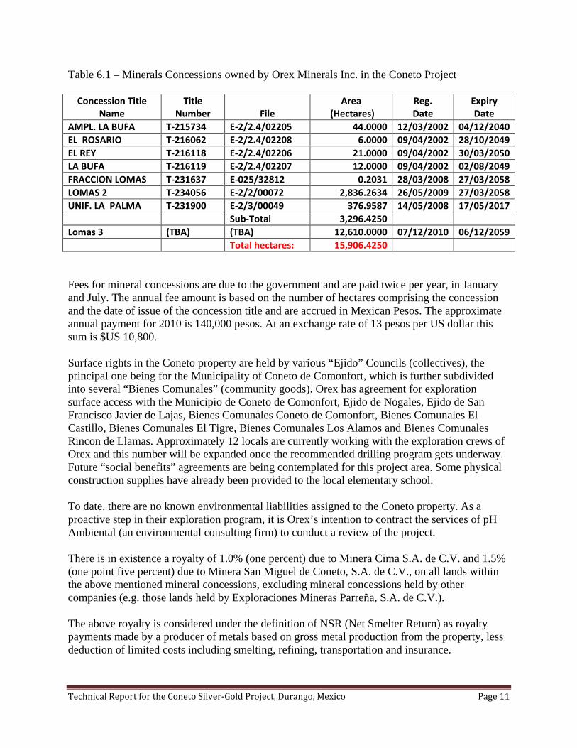
Table 6.1 – Minerals Concessions owned by Orex Minerals Inc. in the Coneto Project
Concession Title Name
Title Number File
Area (Hectares)
Reg. Date
Expiry Date
AMPL. LA BUFA T-215734 E-2/2.4/02205 44.0000 12/03/2002 04/12/2040 EL ROSARIO T-216062 E-2/2.4/02208 6.0000 09/04/2002 28/10/2049 EL REY T-216118 E-2/2.4/02206 21.0000 09/04/2002 30/03/2050 LA BUFA T-216119 E-2/2.4/02207 12.0000 09/04/2002 02/08/2049 FRACCION LOMAS T-231637 E-025/32812 0.2031 28/03/2008 27/03/2058 LOMAS 2 T-234056 E-2/2/00072 2,836.2634 26/05/2009 27/03/2058 UNIF. LA PALMA T-231900 E-2/3/00049 376.9587 14/05/2008 17/05/2017 Sub-Total 3,296.4250 Lomas 3 (TBA) (TBA) 12,610.0000 07/12/2010 06/12/2059 Total hectares: 15,906.4250
Fees for mineral concessions are due to the government and are paid twice per year, in January and July. The annual fee amount is based on the number of hectares comprising the concession and the date of issue of the concession title and are accrued in Mexican Pesos. The approximate annual payment for 2010 is 140,000 pesos. At an exchange rate of 13 pesos per US dollar this sum is $US 10,800.
Surface rights in the Coneto property are held by various “Ejido” Councils (collectives), the principal one being for the Municipality of Coneto de Comonfort, which is further subdivided into several “Bienes Comunales” (community goods). Orex has agreement for exploration surface access with the Municipio de Coneto de Comonfort, Ejido de Nogales, Ejido de San Francisco Javier de Lajas, Bienes Comunales Coneto de Comonfort, Bienes Comunales El Castillo, Bienes Comunales El Tigre, Bienes Comunales Los Alamos and Bienes Comunales Rincon de Llamas. Approximately 12 locals are currently working with the exploration crews of Orex and this number will be expanded once the recommended drilling program gets underway. Future “social benefits” agreements are being contemplated for this project area. Some physical construction supplies have already been provided to the local elementary school.
To date, there are no known environmental liabilities assigned to the Coneto property. As a proactive step in their exploration program, it is Orex’s intention to contract the services of pH Ambiental (an environmental consulting firm) to conduct a review of the project. There is in existence a royalty of 1.0% (one percent) due to Minera Cima S.A. de C.V. and 1.5% (one point five percent) due to Minera San Miguel de Coneto, S.A. de C.V., on all lands within the above mentioned mineral concessions, excluding mineral concessions held by other companies (e.g. those lands held by Exploraciones Mineras Parreña, S.A. de C.V.). The above royalty is considered under the definition of NSR (Net Smelter Return) as royalty payments made by a producer of metals based on gross metal production from the property, less deduction of limited costs including smelting, refining, transportation and insurance.

Technical Report for the Coneto Silver-Gold Project, Durango, Mexico Page 12
Figure 6.1 – Location Map

Technical Report for the Coneto Silver-Gold Project, Durango, Mexico Page 13
Figure 6.2 – Mineral Concession Map

Technical Report for the Coneto Silver-Gold Project, Durango, Mexico Page 14
7. ACCESSIBILITY, CLIMATE, LOCAL RESOURCES, INFRASTRUCTURE AND PHYSIOGRAPHY 7.1 Accessibility
Access to Coneto Project from the city of Durango is excellent. There are two routes to travel to the property. Route 1 (the eastern access) is by all season paved road along highway No. 45 (Durango to Parral) for 106 km, with a western turnoff 1 km north of the intersection for San Juan del Rio, then northwest for 57 km to the village of Coneto de Comonfort. Route 2 (the western access) is by all season paved road along highway No. 45 (Durango to Parral), connecting to highway No. 23 at Guadalupe Aguilera (Guadalupe Aguilera to Santiago Papasquiero) for 105 km to an eastern turnoff at Guatimape. From Guatimape, proceed past the Laguna Santiaguillo, over the Sierra de Coneto for 42 km on mostly paved roads to the village of Coneto de Comonfort. 7.2 Climate The climate is generally dry with sporadic, heavy rainfall in rainstorms during the hot summer months. The average precipitation in the property area is about 600 mm, mainly falling between May and October. The winter months are cool and dry. Snow is rare, but night time temperatures below the freezing mark are common in the higher locations. Yearly average temperatures are about 25º Celsius. Grasses and small shrubs along with several varieties of cacti make up most of the vegetation on the steep hillsides, with larger bushes and mesquite trees near springs and streams, plus pine trees on the higher slopes. 7.3 Local Resources The city of Durango, with a population of about 600,000, is a major mining centre in the region. This is where labour and specialized tradesmen can be sourced, as well as most of the required equipment and parts for current and future programs. The village of Coneto de Comonfort has a population of approximately 1,000 people and is a source of local labour, many of whom have worked for mining ventures in the past. The village also has a public medical unit for emergencies and inter-urban bus transit (Estrella Blanca), with daily service to and from the city of Durango. 7.4 Infrastructure Infrastructure is excellent. There are paved roads to the village of Coneto de Comonfort and a network of gravel and dirt roads throughout the ranching and farming portions of the Coneto property. The village is connected to the public electrical grid. There are water catchment dams in several areas of the property, which can serve as sources for drilling water. Large aquifers also exist in the fault controlled basins to the east.

Technical Report for the Coneto Silver-Gold Project, Durango, Mexico Page 15
A secure mine complex, consisting of several buildings for mechanic shops, assay laboratory, office and accommodations is available and has been offered for leasing to Orex. Orex has arranged for the rental of several houses in the village of Coneto de Comonfort. Also on the property is a small 150 tpd capacity flotation mill, but it is not Orex’s intention to re-activate the mill at this time. 7.5 Physiography On the broader scale, Coneto lies near the eastern side of the Sierra Madre Occidental, on the western edge of the Mexican Altas Llanuras (also known as the Mesa Central), an extensive volcanic plateau characterized by narrow, northwest trending fault-controlled ranges separated by generally flat-floored basins. The basins have elevations of 1,900 m to 2,100 m, and the higher peaks rise to 3,000 m. In the immediate area of the Coneto Project, the western side is a high ridge region called Sierra de Coneto at over 2,700 m. The central and eastern sides consist of a series of smaller hills and valleys with elevations of 2,000 m to 2,200 m.

Technical Report for the Coneto Silver-Gold Project, Durango, Mexico Page 16
8. HISTORY Discovery of gold in the Coneto camp may have occurred as early as 1552, when prospectors for El Capitán Ginés Vásquez del Mercado visited the area and recorded mineralization on La Bufa. The mining activities in the Coneto mining district began in 1572, when a group of Spaniards founded the Real de Coneto. Smelting of minerals of gold and silver was performed in Castilian furnaces (coal) of simple construction and later an amalgamation process was added. The Spaniards left the mines in 1790, due to the presence of water in the workings (Ponce-Sibaje et al., 1978). In the 19th century, foreign companies initiated operations on the Sauce and Palma veins (currently on Orex’s Unificacion La Palma mineral concession), having installed steam engines to pump out mine water, but these activities were suspended in 1910 due to the Mexican Revolution. Tin exploration also took place in the rhyolites to the east of Coneto de Comonfort (Anon., 1888). In the mid-20th century, a North American company installed the first mill with a flotation system, but their operations were suspended in 1973. The activities were started again in 1976 by Compañía Minera Comonfort S.A. de C.V., which stopped operating in the year 1990, due to the low prices for silver (Cardenas-Vargas, 1993). These operations were also in the Palma and Sauce vein areas. In the 1970s and 1980s, the Consejo de Recursos Minerales (CRM) worked on the Coneto project and constructed ramp access to the main mine workings, with the portal located near the old Fortuna Tiro (shaft). Over three years (1978 to 1980) CRM excavated 3,429 metres of underground development, drilled 4,428 metres in 38 holes and took 4,862 channel and core rock samples (Guzman and Alba, 1981). Evaluation of their results is not possible without access to the data. A search is being conducted to locate the original data. Guzman and Alba (1981) also conducted a resource and reserve estimate, but the equivalencies of methodology to the current CIM standards is not known. Also in the 1980s, uranium exploration was in vogue and the hills to the west of Coneto de Comonfort were explored by Uranio Mexicano. Their work focused mainly on the uranium potential in the Upper Volcanic Group, but made reference to the geologic setting of the silver-gold veins in Coneto (Reyes-Cortes, 1985). At the Coneto Mine, silver and gold production records are mostly absent. There is one reference to production in 1989 and 1990 by Compañia Minera Comonfort, S.A. de C.V., showing tonnage processed and recovered grades (Cardenas-Vargas, 1993).
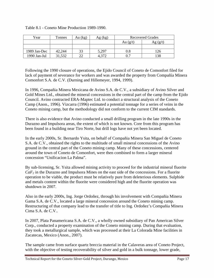
Technical Report for the Coneto Silver-Gold Project, Durango, Mexico Page 17
Table 8.1 - Coneto Mine Production 1989-1990.
Year Tonnes Au (kg) Ag (kg) Recovered Grades Au (g/t) Ag (g/t)
1989 Jan-Dec 42,244 33 5,297 0.8 126 1990 Jan-Jul 31,532 22 4,372 0.7 138
Following the 1990 closure of operations, the Ejido Council of Coneto de Comonfort filed for lack of payment of severance for workers and was awarded the property from Compañía Minera Comonfort S.A. de C.V. (Durning and Hillemeyer, 1994, 1999). In 1996, Compañia Minera Mexicana de Avino S.A. de C.V., a subsidiary of Avino Silver and Gold Mines Ltd., obtained the mineral concessions in the central part of the camp from the Ejido Council. Avino contracted ERA-Maptec Ltd. to conduct a structural analysis of the Coneto Camp (Anon., 1996). Vizcarra (1996) estimated a potential tonnage for a series of veins in the Coneto mining camp, but the methodology did not conform to the current CIM standards. There is also evidence that Avino conducted a small drilling program in the late 1990s in the Durazno and Impulsora areas, the extent of which is not known. Core from this program has been found in a building near Tiro Norte, but drill logs have not yet been located. In the early 2000s, Sr. Bernardo Ysita, on behalf of Compañia Minera San Miguel de Coneto S.A. de C.V., obtained the rights to the multitude of small mineral concessions of the Avino ground in the central part of the Coneto mining camp. Many of these concessions, centered around the town of Coneto de Comonfort, were then combined to form a larger mineral concession “Unificacion La Palma”. By sub-licensing, Sr. Ysita allowed mining activity to proceed for the industrial mineral fluorite CaF2 in the Durazno and Impulsora Mines on the east side of the concessions. For a fluorite operation to be viable, the product must be relatively pure from deleterious elements. Sulphide and metals content within the fluorite were considered high and the fluorite operation was shutdown in 2007. Also in the early 2000s, Ing. Jorge Ordoñez, through his involvement with Compañia Minera Gama S.A. de C.V., located a large mineral concession around the Coneto mining camp. Restructuring of that company lead to the transfer of title to Ing. Ordoñez’s Compañia Minera Cima S.A. de C.V.. In 2007, Plata Panamericana S.A. de C.V., a wholly owned subsidiary of Pan American Silver Corp., conducted a property examination of the Coneto mining camp. During that evaluation, they took a metallurgical sample, which was processed at their La Colorada Mine facilities in Zacatecas, Mexico (Anon., 2007). The sample came from surface quartz breccia material in the Calaveras area of Coneto Project, with the objective of testing recoverability of silver and gold in a bulk tonnage, lower grade,

Technical Report for the Coneto Silver-Gold Project, Durango, Mexico Page 18
open pit target. The following result was received from Pan American Silver Corp. for their sample labelled “Muestra Coneto No.5”, with roughly 80% passing through a -200 mesh sieve size (Anon., 2007). Table 8.2 – Cyanidation Test - Muestra Coneto No.5 -200 Mesh Time (hrs) Head Au Head Ag Final Au Final Ag Recovery
Au Recovery Ag
Consumption NaCN
(g/t) (g/t) (g/t) (g/t) (%) (%) (kg/t)
24 0.137 41.4 0.09 6.70 34.15 83.80 1.050 48 0.232 44.0 0.13 6.30 46.04 85.69 1.250 72 0.144 39.1 0.06 5.65 61.89 85.57 1.325 96 0.253 43.6 0.10 7.50 60.53 82.81 1.400
These results are considered good for a “preliminary” metallurgical test, with 85% silver recovery and 60% gold recovery, as the methods have not been optimized for Coneto. It represents one style of mineralization at Coneto. Further refinement of the method may yield improved recoveries.
Figure 8.1 – Metallurgy Recovery -200 Mesh
Results of this metallurgical testing should be considered preliminary and further testing will be required in the future to better determine leach kinetics and optimum particle size for the various styles of mineralization present at Coneto.

Technical Report for the Coneto Silver-Gold Project, Durango, Mexico Page 19
At that time Pan American was also re-evaluating their corporate approach for acquiring new assets and they were moving toward more advanced development opportunities. Coneto was described as a promising exploration project, but without current reserves/resources it did not meet Pan American’s corporate needs (Steinmann, pers. com. 2009). Management of Orex Minerals Inc. had been interested in Coneto for several years. In April 2009, a property examination was conducted (Whiting, 2009b) and the announcement of formal acquisition of all mineral concessions belonging to Compañia Minera San Miguel de Coneto S.A. de C.V. and Compañia Minera Cima S.A. de C.V. in the Coneto mining camp was released on 16 July 2009 (Orex news release).

Technical Report for the Coneto Silver-Gold Project, Durango, Mexico Page 20
9. GEOLOGICAL SETTING 9.1 Regional Geology The Coneto property is located in a geological subprovince known as the “Mesa Central”, “Altas Llanuras”, or “High Plains,” on the eastern flank of the Sierra Madre Occidental (Figure 9.1). The Mesa Central subprovince is a volcanic-sedimentary highland composed of mainly Tertiary (Paleocene) to Quaternary (Pleistocene) sequences of andesite, dacite-rhyolite and basalt, which in turn rest on a basement of Cretaceous and earlier calcareous and metasedimentary rocks. The present “basin and range” topography reflects a series of north- to northwest-trending linear grabens along the range fronts. In the region extending north of the city of Durango, metasedimentary rocks of Cretaceous age are exposed in small windows through the Tertiary volcanic rock cover. These consist of mudstone, shale, limestone, and polylithic conglomerate with volcanic, sedimentary and limestone clasts. While conglomerates are not widely exposed, they have been shown to be an important unit below such mining camps as La Preciosa (Whiting, 2008; Whiting and Gunning, 2007) and La Pitarrilla (McCrea, 2007). The Cretaceous rocks are covered by a sequence of andesite tuff, flows and agglomerate of the Paleocene-Eocene age Lower Volcanic Group. This corresponds to the rocks exposed in the majority of the central part of Coneto and in the underground workings. In the major hills to the west, known as Sierra de Coneto, the Lower Volcanic Group is overlain by thick sequences of rhyolite and dacite ignimbrite, tuff, felsic intrusives and volcanic breccia of the Oligocene-age Upper Volcanic Group. A good regional overview has been published in a Geological Society of America fieldtrip guidebook (Aranda-Gomez et al., 2003). Some basins and parts of the lower hills are covered with varying thicknesses of Pliocene to Pleistocene basalt that erupted from numerous vents now marked by small volcanic cones and domes that dot the plains, and by Quaternary unconsolidated graben gravels. 9.2 District Geologic Setting Descriptions of the veins are presented under section 11. Mineralization. The host rock to these veins is mainly the Lower Volcanic Group andesites exposed in an erosionary window. Lowest in the sequence and not exposed directly in the Coneto mining camp is the Cretaceous sedimentary units as described by Reyes (1985). During his wider area mapping, he recorded a basement unit of sandstones, tuffaceous sandstones and mudstones, with some folding, followed by increasingly tuffaceous sandstone and conglomeratic units, with minor lenses of limestone. Above these sedimentary rock dominated units is the Tertiary aged Lower Volcanic Group of andesite lava flows, andesite agglomerate and andesite breccias. Near the top of the Lower Volcanic Group, the rocks become progressively more felsic. The Lower Volcanic Group may be in the order of 300 metres thick in Coneto, based on comparisons to other similar camps.

Technical Report for the Coneto Silver-Gold Project, Durango, Mexico Page 21
Sitting unconformably above is the Tertiary aged Upper Volcanic Group, dominated by rhyolites, ignimbrites and felsic intrusive, the contact with which can clearly be seen along the access road south of Coneto. Most of the Sierra de Coneto to the west is composed of Upper Volcanic Group. A Pleistocene, post-mineralization conglomerate is exposed mainly along the northeastern margin of the Coneto mining camp, along with younger basalt and basaltic andesite units. Veins project below these younger units and may constitute blind targets. Associated with the mineralization structures are variable degrees of hydrothermal alteration, including kaolinitization, silicification, and pyritization, with later meteoric waters oxidizing the upper levels of the vein systems.

Technical Report for the Coneto Silver-Gold Project, Durango, Mexico Page 22
Figure 9.1. – Geological Map – Central Area Veining

Technical Report for the Coneto Silver-Gold Project, Durango, Mexico Page 23
10. DEPOSIT TYPES Coneto is considered to be a low- to intermediate-sulfidation silver and gold epithermal deposit typical of the Mexican silver belt. Low-sulfidation vein systems are commonly characterized by their low sulfide contents, quartz-adularia-sericite alteration mineralogy, and lack of extensive wallrock alteration. High-sulfidation vein systems are commonly characterized by sulfur saturation leading to the presence of native sulfur and sulfide minerals, quartz-alunite alteration mineralogy and extensive wallrock alteration. Most Mexican silver deposits are usually not at the end member classifications and often fit in the intermediate-sulfidation position. Buchanan (1981) proposed an idealized model for epithermal systems, incorporating a series of subvertical veins that bifurcate and pass upward into a mushroom shaped sub-horizontal “silica cap” at or near the paleosurface. Deep in the system, the veins often have a base metal root, with increasing precious metals near the boiling level of vein emplacement. Bonanza-grade gold and silver mineralization may occur near this level. The highest levels in the system, including the silica cap, commonly have anomalous mercury, arsenic and antimony geochemistry with low precious and base metals values. More specific to epithermal deposits in Mexico are the presence of flatter vein and stockwork structures along unconformity contacts, related to the steeper veins. In addition, the hydrothermal fluids contained HF acid, which leached carbonate units and lead to the precipitation of fluorite (CaF2) high in the epithermal system (Whiting, 2009c). The geology and style of mineralization at Coneto are similar to those of other silver producing districts in the western Americas. Mexico is host to many silver-gold districts, alternating with Peru as the largest silver producer in the world. The following comments are intended to provide examples of mining districts that have geology and mineralization similar in general style to those of the Coneto property. There is no intention to draw direct comparisons between Coneto and any other mining district other than for the purposes of guiding exploration efforts. Tonnages and grades vary widely among deposits of similar types and the authors do not imply that tonnages and grades described for other deposits should be assumed to exist at Coneto. In northwestern Mexico, there is a Gold-Silver Trend on the western side of the Sierra Madre Occidental mountains and a dominantly Silver Trend on the eastern side of the Sierra Madre Occidental Mountains and adjacent high plateaus. Coneto is in the Silver Trend, which stretches from Guanajuto through Zacatecas and Durango to Chihuahua and Sonora. Three of the most significant deposits in this Silver Trend are Fresnillo, La Pitarrilla, and La Preciosa. Note: As with other sections of this report, where silver-equivalent values appear in this section, they are determined by the silver value plus 60 times the gold value. The 10-year running average (2000-2010) of gold to silver prices is 60 to 1 for the London Metal Exchange. For the purposes of silver-equivalent, precious metal recovery is assumed to be 100%. Base metals and fluorite values are not included. The famous Fresnillo silver mining district in neighboring Zacatecas State contains many high-grade silver vein deposits. Fresnillo, like Coneto, is located on the eastern side of the Sierra

Technical Report for the Coneto Silver-Gold Project, Durango, Mexico Page 24
Madre Occidential mountains on the Mesa Central. One of the larger, classic veins of this camp is the Santo Niño vein. At surface, the vein is not well exposed, occurring as a small stockwork and veinlets. The Santo Niño vein was discovered by drilling at a depth of ~300m below surface and has now been followed for 2.5 km in length, 500 m in depth and a width of 0.1 to 4.0 m (average 2.5 m). The discovery hole in 1975 intersected 1,087 g Ag/t, 1.62 g Au/t, 0.4% Pb and 0.7% Zn over a true width of 3.0 m. This vein has become the largest silver producer in the Fresnillo camp (Gemmel et al., 1988). Production to date in the Fresnillo camp has exceeded 1.2 billion ounces of silver. Production in 2007 was 34.4 million ounces silver and 280,000 ounces gold for a silver-to-gold ratio of 123:1 (Megaw, 2008). In December 2008, Jaime Lomelin, CEO of Fresnillo PLC, announced that they were proceeding to develop a “Fresnillo-II” mine south of the main Fresnillo mine (Lomelin, 2008). A high-grade discovery in the Fresnillo camp was made by a joint venture between Mag Silver Corporation and Fresnillo PLC (a part of the Peñoles Group) on the Juanicipio Project’s Valdecañas Vein. On March 4, 2009 Mag Silver Corp. reported an Indicated Resource for the Valdecañas Vein estimate (including the Hanging Wall Vein) of 2.95 million tonnes of 879 g/t Ag, 2.22 g/t Au, 2.39% Pb and 4.15% Zn. The Inferred Resource (Valdecañas, Footwall and Hanging Wall Veins and the Stockwork Zone) is estimated at 7.21 million tonnes of 458 g/t Ag, 1.54 g/t Au, 1.89% Pb and 3.14% Zn. The total contained metals in the Indicated Resource at Juanicipio are 83 million ounces of silver, 210,000 ounces of gold, 155 million pounds of lead and 269 million pounds of zinc. The Inferred Resources contain an additional 106 million ounces of silver, 356,000 ounces of gold, 301 million pounds of lead and 498 million pounds of zinc. The silver:gold ratio is 334:1. Next, two deposits are considered as proximal models for Coneto. Fifty kilometres to the northwest of Coneto is the discovery of La Pitarrilla deposit by Silver Standard Resources Inc. (McAra et al., 2009; Puritch and Yassa, 2008; Ewert et al., 2008; McCrea, 2007). Seventy kilometres to the southeast of Coneto is the discovery of La Preciosa deposit by Orko Siver Corp. (Whiting, 2009a; Ristorcelli et al., 2009; Whiting, 2008(a,b); Monsivais and Whiting, 2008; Whiting and Monsivais, 2008; Whiting, 2006b). The geological setting of the host rocks at both La Pitarrilla and La Preciosa consists of a Cretaceous age sedimentary sequence at depth, with permeable conglomerate units at an unconformity with overlying Tertiary aged andesite of the Lower Volcanic Group. This is capped by younger Tertiary aged rhyolites of the Upper Volcanic Group. Mineralization is related in time to the emplacement of the rhyolite and associated dacite intrusives. In the case of La Pitarrilla, the rhyolites and dacites are proximal to the deposits. In the case of La Preciosa (and likely Coneto), the rhyolites and dacites are west of the deposits. In La Preciosa, and to a lesser extent in La Pitarrilla, there are high-level epithermal veins and stockwork zones. These correspond to the exposed veins in the Coneto mining camp and are still a good target for vein type gold-silver mineralization below the levels of fluorite mineralization. However, potentially more importantly, there is a broader, passive emplacement of mineralization along a zone of permeability at the unconformity contact. At La Preciosa, this zone is the relatively flat Martha vein structure and it extends along strike for over 3 kilometres,

Technical Report for the Coneto Silver-Gold Project, Durango, Mexico Page 25
down dip for 1.7 kilometres and is up to 40 metres thick (Whiting, 2009a). At La Pitarrilla, this would coincide with the “replacement sulphide mineralization” at the basal conglomerate unit (McCrea, 2007). Six successive resource estimates have been prepared for La Preciosa since 2006 (Ristorcelli et al., 2009; Whiting, 2008a; Whiting and Gunning, 2007; Whiting, 2007; Whiting, 2006a; Gunning and Whiting, 2006). As of March 2009, the resource estimates stood in two categories as follows: Indicated Resource of 10.6 million tonnes grading 185 g/t Ag and 0.27 g/t Au for a silver-equivalent of 201 g/t contain 68.9 million ounces silver-equivalent. Inferred Resource of 12.1 million tonnes grading 185 g/t Ag and 0.25 g/t Au for a silver-equivalent of 200 g/t contain 77.5 million ounces silver-equivalent. (Ristorcelli et al., 2009). The silver:gold ratio at La Preciosa is 706:1. The latest published resource estimate on La Pitarrilla as of August 2008 has Measured and Indicated Resources at 172.6 million tonnes grading 73.8 g/t Ag for a contained silver content of 409.3 million ounces. Inferred Resources stood at 24.8 million tonnes grading 56.0 g/t Ag for a contained silver content of 44.7 million ounces (Ewert et al., 2008). The silver:gold ratio was not reported for La Pitarrilla. Information on properties included under Deposit Types is used to illustrate the types of mineralization targets for the Coneto Project from an exploration viewpoint. These properties (Fresnillo, Juanicipio, La Preciosa, La Pitarrilla) are not included in the boundaries of the Coneto Property as defined in this technical report. While the authors have no reason to doubt the validity of any resource estimates presented above for Deposit Types, as quoted from publically disclosed references, the following cautionary statement applies. The authors have not personally verified the information on all Deposit Type properties and this information is not necessarily indicative of the extent of mineralization to be found on the Coneto Property.

Technical Report for the Coneto Silver-Gold Project, Durango, Mexico Page 26
11. MINERALIZATION Mineralization in the Coneto mining camp is of the intermediate sulphidation style of epithermal vein emplacement. The corridor of veining and associated hydrothermal alteration extends approximately 15 km in a NW-SE direction, the dominant strike direction of the veins, and 4 km in a SW-NE direction, across multiple veins. Four main stages of vein emplacement have been identified in many of the veins (Anon, 1996), with variations in this pattern. Stage 1: - White recrystallized quartz, often with a saccroidal texture and pseudomorphs after calcite. This early stage is not mineralized. It is part of a process whereby bladed calcite was precipitated then dissolved and replaced by quartz. Stage 2: - Smoky, fine grained quartz, with pyrite and argentite. This represents the main ore-stage emplacement and typically contains higher silver and gold values. It is in places in the form of a cementing matrix within breccias of Stage 1 quartz, which indicates a reactivation of the system Stage 3: - Coarse, white to clear, coxcomb quartz veins, without appreciable sulphides. Stage 4: - Quartz-fluorite veins, or infilling of druzy cavities within pre-existing veins. There are over 40 veins documented in the Coneto mining camp. Some individual veins have been mapped for over 2 km along strike and vary from 1 to 20 metres thick. Testing on most veins has not gone below 100 metres down-dip. In addition, there are both quartz stockwork and breccias in both hanging and footwall zones of major veins. The quartz veins are more resistant to weathering than the host rocks and are therefore easily seen in outcrop. It is possible that some of the veins are faulted offsets of other veins, as the faults would be less obvious on surface than the veins and thus not as well documented. The following is a brief description of some of the major veins, grouped by mine access and/or area on the property. Note: As with other sections of this report, where silver-equivalent values appear in this section, they are determined by the silver value plus 60 times the gold value. The 10-year running average (2000-2010) of gold to silver prices is 60 to 1 for the London Metal Exchange. For the purposes of silver-equivalent, precious metal recovery is assumed to be 100%. Base metals and fluorite values are not included.

Technical Report for the Coneto Silver-Gold Project, Durango, Mexico Page 27
Figure 11.1. – Main Veins in the Coneto Mining Camp.
Technical Report for the Coneto Silver-Gold Project, Durango, Mexico Page 28
11.1. – Coneto Mine The Coneto Mine is located to the east of the village of Coneto de Comonfort and was the starting point for historic production in this camp. Four shafts (General, Fortuna, Norte and a minor El Tiro) and a ramp near the Fortuna shaft were driven on the historic mine workings. This is on Orex’s Unificacion La Palma mineral concession. The Sauce Vein has development on several levels and, according to longitudinal sections, shows stope development on two clavos (ore-shoots), one of which daylights in a glory hole northwest of the General shaft at the intersection of Sauce and Pobre Veins. Personal communication with several locals and with past mine operators have stated that their highest grades came from this structure. The Sauce Vein is oriented 130o – 65o SW. Stages 1, 2 and 4 have been documented in this vein. Down dip projection on these clavos, below the water table, is a favourable exploration target. The Pobre Vein is a splay off of the Sauce Vein to the south and is poorly exposed. It has a general orientation of 170o -80o. Mineralogically, it may have lacked the more resistant Stage 1 quartz, but contained more of the economically important Stage 2 quartz-sulphide veining and stringers. Several of the shallow levels on the Sauce Vein workings were extended along the Pobre Vein. The down-dip projection of the clavo and the southern projection of Pobre Vein are exploration targets. The Palma Vein is the second most important vein in the Coneto Mine and is oriented between 140o and 165o -65o SW. The Palma workings stretch from the Norte shaft, past the Fortuna shaft and the General shaft in the south, until they merge with the Sauce Vein workings. Stoping may be preferentially located on inflections in the strike of the Palma Vein. Stage 1 and 2 veining are present, as well as a zone of footwall brecciation and stockwork. The Palma Vein is well exposed in the mine compound. Speculation as to what happens to the Palma Vein as it trends northward include possible blind targets beneath a post-mineralization conglomeratic unit, and offsets to sub-parallel veins to the east. The Tajo Vein is a north-south trending vein, averaging 175o -80o W, which was historically accessed via the early, small Tajo shaft. As one of the first veins to be mined in the district, surface pits are overgrown and obscured. There is also indication from the underground plans that a crosscut from the CRM ramp may have been designed to intersect the Tajo shaft, but was only partly completed for 125 metres. Little information is available about this vein, as well as the 125o striking Santa Teresa Vein in the Coneto Mine area. 11.2. – Durazno Mine In the Durazno Mine area, there is a small open cut and a ramp leading to four mining levels. These were developed to explore and produce from the main Durazno Vein for high-grade fluorite. . This is on Orex’s Unificacion La Palma mineral concession.

Technical Report for the Coneto Silver-Gold Project, Durango, Mexico Page 29
Access to the first level is open, but the lower levels are currently flooded. This vein is oriented 150o - 65o SW, has been traced for over 1500 m and is up to 20 m thick. Fluorite grade drops off with depth, but silver and gold grades increase with depth. Several historic drill holes reported silver and gold values (see section 13. Drilling), including a 10.97 metre intercept grading 20.53 % CaF2, 2.29 g/t Au and 71.7 g/t Ag for a silver-equivalent of 209.2 g/t. North of the Durazno Vein is a more east-west trending vein called Tres Amigos. There is a small underground working on Tres Amigos. It is possible that one of the widenings of the Durazno Vein may be related to the intersection with the Tres Amigos Vein. South of the Durazno Mine workings, the vein splits into two splays, the western splay projecting toward the Impulsora Mine (see below), and the eastern splay projecting toward La Isla, a rock knoll within the catchment basin of a reservoir. On this knoll is Isla Vein, oriented about 130o -80o SW, with breccias and silicification of the host rock. Further south still, west of the reservoir dam, Isla Vein can be picked up again as Isla Sur Vein. Surface rock channel samples yielded gold and silver values in this area (see section 12 Exploration). 11.3. – Impulsora Mine The Impulsora veins are considered to be the main southern extension of the Durazno Vein. . This is on Orex’s Unificacion La Palma mineral concession. There are two closely spaced veins, Impulsora 1 and 2, oriented about 140o -75o SW, up to 4 m wide, with some flexures and splays between the veins. A portal is located on the west side, entering the ridge, with drifts on both veins and a stope on the north end of the easternmost Impulsora 2 Vein. This stope daylights on the ridge crest. The mine was in production for fluorite, but grades were low and concentrate was considered to be relatively dirty due to the iron oxides present in the quartz-fluorite vein. This is considered a good target area and the old mine workings are being re-sampled for gold and silver. Further south, the Impulsora Vein tends to pinch out and horsetail. Across a covered area occasional quartz float can be found, then the vein re-appears and is named Impulsora Sur. In this southern area the vein has been traced for another 500 metres to the southeast and is gold and silver bearing on surface (see section 12. Exploration). A projection of Impulsora Sur extends onto Fresnillo’s Soledad mineral concession. 11.4. – Promontorio Ridge Promontorio Ridge is located to the west of the Impulsora Mine and is in-line with the Colemanito, Calaveras, and Coneto Mine structural trend. This is on Orex’s Unificacion La Palma and Lomas 2 mineral concessions.

Technical Report for the Coneto Silver-Gold Project, Durango, Mexico Page 30
Strong quartz veining, with associated stockwork, silicification and kaolinitization can be followed for approximately 2 km oriented 130o -80o SW. There is one old mine access crosscut and drift called Nogales adit on Promontorio, near the northwest end, but it is inaccessible. Much of the early results from Orex’s exploration and sampling (interim report in a news release dated 17 November 2009) came from the Promontorio Ridge area (see section 12. Exploration). This area also has potential for an at surface bulk tonnage target. A projection of Promontorio also extends onto Fresnillo’s Soledad and Ampl. Samaritano mineral concessions. 11.5. – Colemanito Colemanito is a veined and silicified hill midway between the northwest end of Promontorio Ridge and Calaveras. This is on Orex’s Unificacion La Palma and Lomas 2 mineral concessions. It exposes veining for about 300 metres oriented 120o and is mostly Stage 1 quartz veining. Stage 2 veining, the precious metals stage, only appears in pockets at surface along a broad zone of stockwork, thus Colemanito is a secondary target. However, if it connects with Promontorio, the mineralizing event stage may pick up with depth. No historic mine workings are known on this target. 11.6. – Calaveras Area The Calaveras area is between the Colemanito hill to the southeast and veins of the Coneto Mine to the northwest. This is on Orex’s Unificacion La Palma mineral concession. There is a very distinctive surface slot-cut on the margins of the Calaveras vein, which appears to be mining of silicified hanging wall breccias adjacent to the hard quartz vein. This is believed to be the location where the metallurgical sample (see section 18. Metallurgy) was taken by Pan American Silver Corp (Anon., 2007). Close to the west is a sub-parallel Estrellas Vein, also with smoky quartz-matrix filled breccias of Stage 2. Northeast of this area is an east-west trending alteration zone and quartz veining area called Coronado. More study is required to identify the relationship between the Calaveras and Coronado structures. 11.7. – Loma Verde Mine Parallel to and west of the Central mineralized trend is the Loma Verde trend, 1 km west of the village of Coneto de Comonfort. This is on Orex’s Lomas 2 mineral concession. Loma Verde 1 and 2 Veins have been documented in this area, as well as possible splays to the south called Gambusino and Guadalupe. All four vein stages are present in the Loma Verde area. There is also extensive limonite and kaolinite alteration to the south of Loma Verde.

Technical Report for the Coneto Silver-Gold Project, Durango, Mexico Page 31
Loma Verde 1 trends 170o -80o E, then splits in two, with the eastern branch trending 145o. The Guzman and Alba (1981) reference describes a drill hole into Loma Verde 1 which yielded 3.15 metres grading gold 2.35 g/t and silver 224 g/t for a silver-equivalent of 365 g/t (see Section 13. Drilling). 11.8. – Consuelo Area Projecting southeastward from the Pobre Vein are exposures of the Consuelo, Indio, and branching eastward the Descubridora Veins. Very little documentation is available for these veins, but they have been added to the Orex mapping program. A portion of these veins are on Orex’s Unificacion La Palma and Lomas 2 mineral concessions and project onto mineral concessions 3-EN-1-F2 and Ampl. Samaitano of Fresnillo. 11.9. – Coneto Norte North of the village of Coneto de Comonfort are located the Rosario, Cerro Colorado and Guadalupe (or Guadalupana) Veins. This Guadalupe Vein is the second vein of the name Guadalupe in the Coneto mining camp, illustrating the history of the camp having been separate operations. These veins are mainly on Orex’s Unificacion La Palma mineral concession, with a northward projection toward the 3-EN-1-F2 mineral concession of Fresnillo. The Guadalupe Vein, oriented 135o -75o NE, is generally quite thin, but can be traced for a kilometre, with some wider portions, particularly where the Rosario splay occurs. At this intersection is a large terrero rock pile, suggesting that there was a significant shaft dug at this location. Copper bearing minerals, chalcopyrite and malachite, were documented at the northern part of Rosario Vein, marking a difference in mineralogy from other areas of the camp. Cerro Colorado Vein is parallel to and east of Rosario Vein. Further to the north the veins project under post-mineralization conglomerate units. 11.10. – La Bufa Mine The distinctive steep-sided hill and the adjacent hill to its west, 3 km northeast of the village of Coneto de Comonfort, is the area known as La Bufa. This is covered by Orex’s La Bufa and Amol. La Bufa mineral concessions. Several veins have small mine workings in the La Bufa area. The Santo Niño Vein has some inflections, which may be important controls, but the vein generally trends about 150o -80o. Mining here was primarily for gold, as the Stage 2 veining seems to be quartz, with pyrite/limonite. Stage 1 quartz veining is present and there may be an earlier stage of reddish chert and chalcedonic quartz (Stage 1a). The San Miguel Vein is oblique to the Santo Nino Vein and intersection is near the exploration adit. It trends 130o -80o NE and is associated with stockwork and zones of intense silicification. On the eastern side of La Bufa is the East Bufa Vein. It trends about 150o and dips steeply eastward at the south end and steeply westward at the north end. Stages 1, 2, 3 and 4 have been

Technical Report for the Coneto Silver-Gold Project, Durango, Mexico Page 32
described along its length, as well as a possible late stage 5 calcite veining. The intensity of veining, alteration and shear/gouge zone contacts may be a reflection in changes in host rock lithology, from andesitic at the base to more rhyolitic near the top. 11.11. – Naga Nega Mine Three km west of the village of Coneto de Comonfort, 1.5 km west of the Loma Verde area, is the Naga Nega Mine. It is located on mineral concessions Los Naga Nega and Los Naga Nega Dos (privately held concessions) and projects onto Orex’s Lomas 2 mineral concession. This is a small historic operation on the Naga Nega 1 and 2 and Iguana Veins, a system running parallel to the Loma Verde system. It trends 170o and dips -60o to -75o west. Emplacement is high in the system, near the contact between the Upper Volcanic Group and the Lower Volcanic Group (Davila, 2009). Strong argillic alteration and iron oxides are present. Historic mining has not likely gone below 30 metres on these structures. 11.12. – Cerro Prieto At the northern end of the trend lies Cerro Prieto, 10 km northwest of the village of Coneto de Comonfort. There are limonitic alteration zones and calcitic veins on Orex’s El Rey, El Rosario and Lomas 3 mineral concession and the privately held Cerro Prieto mineral concession. This is an additional region which will require further study.
Technical Report for the Coneto Silver-Gold Project, Durango, Mexico Page 33
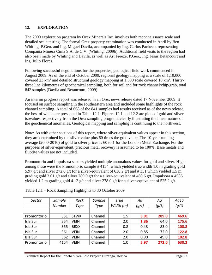
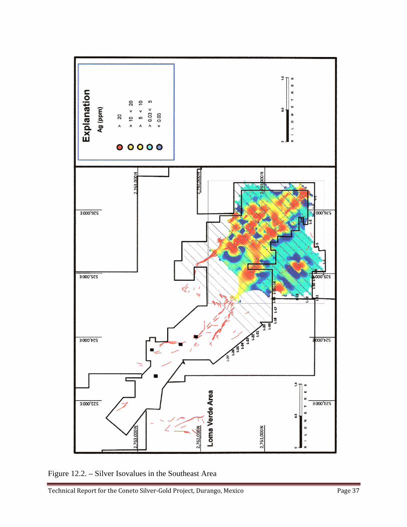
12. EXPLORATION The 2009 exploration program by Orex Minerals Inc. involves both reconnaissance scale and detailed scale testing. The formal Orex property examination was conducted in April by Ben Whiting, P.Geo. and Ing. Miguel Davila, accompanied by Ing. Carlos Pacheco, representing Compañia Minera Cima S.A. de C.V. (Whiting, 2009b). Additional field visits to the region had also been made by Whiting and Davila, as well as Art Freeze, P.Geo., Ing. Jesus Betancourt and Ing. Julio Flores. Following successful negotiations for the properties, geological field work commenced in August 2009. As of the end of October 2009, regional geology mapping at a scale of 1:10,000 covered 23 km2 and detailed structural geology mapping at 1:500 scale covered 10 km2. Thirty-three line kilometres of geochemical sampling, both for soil and for rock channel/chip/grab, total 842 samples (Davila and Betancourt, 2009). An interim progress report was released in an Orex news release dated 17 November 2009. It focused on surface sampling in the southeastern area and included some highlights of the rock channel sampling. A total of 668 of the 841 samples had results received as of the news release, the best of which are presented in Table 12.1. Figures 12.1 and 12.2 are plots of gold and silver isovalues respectively from the Orex sampling program, clearly illustrating the linear nature of the geochemical anomalies. Geological mapping and sampling is continuing to the northwest. Note: As with other sections of this report, where silver-equivalent values appear in this section, they are determined by the silver value plus 60 times the gold value. The 10-year running average (2000-2010) of gold to silver prices is 60 to 1 for the London Metal Exchange. For the purposes of silver-equivalent, precious metal recovery is assumed to be 100%. Base metals and fluorite values are not included. Promontorio and Impulsora sectors yielded multiple anomalous values for gold and silver. High among these were the Promontorio sample # 4154, which yielded true width 1.0 m grading gold 5.97 g/t and silver 272.0 g/t for a silver-equivalent of 630.2 g/t and # 351 which yielded 1.5 m grading gold 3.01 g/t and silver 289.0 g/t for a silver-equivalent of 469.6 g/t. Impulsora # 4586 yielded 1.2 m grading gold 4.12 g/t and silver 278.0 g/t for a silver-equivalent of 525.2 g/t. Table 12.1 – Rock Sampling Highlights to 30 October 2009
Sector Sample Rock Sample True Au Ag AgEq Number Type Type Width (m) (g/t) (g/t) (g/t)
Promontorio 351 STWK Channel 1.5 3.01 289.0 469.6 Isla Sur 354 VEIN Channel 2.0 1.86 64.0 175.6 Isla Sur 355 BRXX Channel 0.8 0.43 83.0 108.8 Isla Sur 361 VEIN Channel 2.0 0.85 72.0 122.8 Isla Sur 362 VEIN Channel 2.0 0.90 49.0 102.8 Promontorio 4154 VEIN Channel 1.0 5.97 272.0 630.2

Technical Report for the Coneto Silver-Gold Project, Durango, Mexico Page 34
Promontorio 4164 BRXX Channel 1.5 2.45 6.0 153.0 Promontorio 4165 VEIN Channel 1.5 1.28 6.0 82.8 Promontorio 4166 BRXX Channel 1.5 2.31 102.0 240.6 Promontorio 4195 VEIN Channel 1.4 1.92 106.0 221.2 Promontorio 4196 VNST Channel 2.8 1.63 53.0 150.8 Promontorio 4197 VNST Channel 1.8 4.89 11.0 304.4 Impulsora 4204 STWK Channel 1.3 2.11 12.0 138.6 Impulsora 4213 VNBX Channel 0.7 5.03 76.0 377.8 Promontorio 4245 STWK Channel 2.5 1.26 12.0 87.6 Promontorio 4248 STWK Channel 2.3 1.12 13.0 80.2 Impulsora 4276 ANVT Channel 2.0 1.12 5.0 72.2 Promontorio 4283 BRXX Channel 1.7 0.23 101.0 115.0 Promontorio 4321 BRXX Channel 1.6 0.37 83.0 105.3 Promontorio 4329 STWK Channel 2.0 3.33 8.0 207.8 Promontorio 4331 STWK Channel 2.0 2.10 15.0 141.0 Promontorio 4338 STWK Channel 2.0 2.65 1.5 160.5 Unnamed 4365 ANVT Channel 0.5 1.13 22.0 89.8 Unnamed 4371 VEIN Channel 1.5 0.99 47.0 106.5 Unnamed 4406 ANVT Chips 1.5 1.96 180.0 297.6 Promontorio 4420 BRXX Channel 1.0 0.88 144.0 196.7 Promontorio 4422 ANVT Channel 1.2 1.52 237.0 328.2 Impulsora 4430 VEIN Channel 1.0 1.34 129.0 209.4 Impulsora 4433 ANVT Channel 2.0 1.34 18.0 98.4 Impulsora 4455 VEIN Channel 1.0 1.22 173.0 246.2 Impulsora 4456 ANVT Channel 2.0 2.71 96.0 258.6 Promontorio 4462 STWK Chips 1.0 1.13 27.0 94.8 Promontorio 4463 ANVT Chips 1.0 1.95 5.0 122.0 Impulsora 4530 BRXX Channel 1.7 1.02 26.0 87.2 Impulsora 4531 BRXX Channel 1.0 1.84 92.0 202.4 Impulsora 4532 BRXX Channel 1.1 1.20 46.0 118.0 Colemanito 4568 VEIN Channel 1.0 0.68 127.0 168.0 Impulsora 4576 BRXX Channel 1.0 1.84 211.0 321.4 Impulsora 4577 ANVT Channel 1.0 1.96 168.0 285.6 Impulsora 4586 BRXX Channel 1.2 4.12 278.0 525.2 Impulsora 4588 BRXX Channel 1.0 1.68 77.0 177.8 Impulsora 4589 ANVT Channel 2.0 1.25 55.0 130.0 Colemanito 4606 VEIN Channel 1.0 2.10 35.0 161.0 Descubridora 4621 ANVT Channel 1.3 0.76 97.0 142.7 Colemanito 4633 ANVT Channel 0.5 0.14 107.0 115.1 Colemanito 4635 VEIN Channel 1.2 0.13 134.0 141.6 Colemanito 4637 BRXX Channel 1.8 3.17 13.0 203.2 Impulsora 4644 BRXX Channel 1.5 2.16 109.0 238.6

Technical Report for the Coneto Silver-Gold Project, Durango, Mexico Page 35
Calaveras 4800 ANVT Channel 0.6 0.17 99.0 109.3 Pobre 4826 VEIN Grab n/a 1.16 436.0 505.6 Pobre 4827 ANVT Channel 1.1 0.21 288.0 300.4 Unnamed 4832 ANVT Chips 1.8 1.05 43.0 106.0 Host rock is primarily andesite of the Triassic Lower Volcanic Group. Sample rock type abbreviations used in the table are ANVT andesite with quartz veinlets, BRXX breccia, STWK stockwork, VEIN quartz vein, VNBX vein breccias and VNST vein stockwork.

Technical Report for the Coneto Silver-Gold Project, Durango, Mexico Page 36
Figure 12.1. – Gold Isovalues in the Southeast Area
Technical Report for the Coneto Silver-Gold Project, Durango, Mexico Page 37
Figure 12.2. – Silver Isovalues in the Southeast Area

Technical Report for the Coneto Silver-Gold Project, Durango, Mexico Page 38
13. DRILLING Orex Minerals Inc. has not yet commenced a drilling program on Coneto, but has plans to do so during 2010. There has been historic drilling on the Coneto property, the types of drill rigs, procedures followed and the complete results and conclusions are “unknown”. Information on the historic drilling programs is fragmentary. (Note: There has not been, nor is there currently a requirement for companies working in Mexico to file with the government assessment reports on the results of their drilling programs.)
There is evidence of historic drilling on the property, in the form of a few drill hole collar pipes, underground drill markers, and scattered report references, but the information database is sparse. Throughout the whole camp, there may be in the order of 70 short drill holes by several companies and a search is on for this information. One historic drill program where some of the information is available is from a report prepared for the Comision de Fomento Minero described a part of the 1972 drilling program on the Durazno Vein by Servicios Administrativos Frisco S.A. de C.V. (Veytia-Barba, 1974). The report focused more on the fluorite potential of the structure and groundwater, but included a portion of the drill logs with gold and silver assays. The following summary is of significant intercepts in the Durazno Vein oriented 150o – 65o SW, illustrating its precious metals potential. Table 13.1 - Drill Hole Summary from 1972 in the Durazno Mine Area
Hole From (m)
To (m)
Core Length
True Width
CaF2 (%)
Au (g/t)
Ag (g/t)
Ag-Eq (g/t)
B72-10 38.71 45.26 6.55 6.15 25.07 0.94 100.8 157.3 Includes 40.84 45.26 4.42 4.15 23.26 1.28 138.9 215.4 Includes 42.98 45.26 2.29 2.15 39.00 2.00 219.0 339.0 B72-12 19.35 25.36 6.01 4.92 25.02 1.08 63.4 128.5 Includes 19.35 21.18 1.83 1.50 18.00 2.42 114.7 259.7 Includes 19.96 21.18 1.22 1.00 23.40 3.00 145.0 325.0 B72-14 38.56 43.28 4.72 3.87 62.57 0.15 33.1 41.8 Includes 38.56 39.47 0.91 0.75 35.80 0.75 92.0 137.0 B72-22 33.53 46.63 13.10 12.31 27.93 1.92 62.5 177.6 Includes 33.53 44.50 10.97 10.31 20.53 2.29 71.7 209.2 Includes 33.53 40.08 6.55 6.15 10.50 3.50 85.0 295.0

Technical Report for the Coneto Silver-Gold Project, Durango, Mexico Page 39
In the 1970s and 1980s, the Consejo de Recursos Minerales (CRM) worked on the Coneto project and constructed ramp access to the main mine workings, with the portal located near the old Fortuna Tiro (shaft). Over three years (1978 to 1980) CRM excavated 3,429 metres of underground development, drilled 4,428 metres in 38 holes and took 4,862 channel and core rock samples, of which 633 samples were from diamond drilling (Guzman and Alba, 1981). A search is being conducted to locate the original data, thus no interpretation of results is included here. The CRM drilling consisted of 37 holes in the Mina La Palma area totalling 4,267.85 metres. These were divided into Area Tiro Prieto in the south, Area La Palma in the centre and Area Tiro Norte north of the main compound. From surface, 10 holes were drilled in the Area Tiro Prieto for 1,545.50 m, 10 holes in Area La Palma for 1,545.50 m and 4 holes in Area Tiro Norte for 775.00 m. Drilling from underground included 13 short holes totalling 352.25 m. It is known that Consejos Recursos Minerales also drilled a hole in the Loma Verde Vein area on the west side of the Coneto mining camp (Guzman and Alba, 1981). An English translation of Guzman and Alba (1981) observations is presented herein: “Preliminary diamond drilling in one hole to a depth of 181.00 metres cut the Loma Verde Vein at 150.00 metres, below the inclined tunnel on Loma Verde, and contained good grades of gold and silver. The grades are as follows: Au = 2.35 g/t --- Ag = 224 g/t --- Width = 3.15 m ……………. (Ag-Eq = 365 g/t)* The results obtained indicate the necessity to continue exploration work of diamond drilling on this zone.” The collar for this hole has been located. The Loma Verde vein is oriented 000o – 75o E and the true thickness of the above intercept is 2.7 metres. An additional drilling program was planned for the Loma Verde area by earlier reviewers, but it was not carried out (Pinto, 1998). Drilling by Compañia Minera Mexicana de Avino S.A. de C.V. in the late 1990s is evident by the remains of drill core found in a building near Tiro Norte, with the Avino company name on the boxes. How many holes and the total length of drilling is unknown. The amount of drilling was in the order of 1,000 metres, but the core storage was poor and the information on the results have not been found. * Note: As with other sections of this report, where silver-equivalent values appear in this section, they are determined by the silver value plus 60 times the gold value. The 10-year running average (2000-2010) of gold to silver prices is 60 to 1 for the London Metal Exchange. For the purposes of silver-equivalent, precious metal recovery is assumed to be 100%. Base metals and fluorite values are not included.

Technical Report for the Coneto Silver-Gold Project, Durango, Mexico Page 40
14. SAMPLING METHOD AND APPROACH 14.1 – The 2009 Program The current exploration program by Orex Minerals Inc. is a surface mapping and sampling effort to guide an upcoming phase of diamond drilling. It involves sampling of soil and rock chips on northeast oriented sample lines, spaced 100 metres apart, with sample stations at 50 metres intervals. Stations are marked with a wooden peg. Where veins and/or stockwork zones are exposed in outcrop, channel samples are taken. At the time of writing this report, the Orex program had advanced through the southeast third of the central area of Coneto. Along 33 line-kilometres of testing, 374 channel, 350 chip and 118 soil, totalling 842 samples had been taken and the results of 668 analyses had been received from SGS Mineral Services. Channel sampling of structures exposed in outcrop was performed by first documenting the structure and position, cleaning the outcrop, marking the sample location over intervals less than or equal to 2 metres, chiselling off approximately 2 to 4 kg of representative sample, and painting the sample number on site. Chip samples are similar to channel samples, except that a dominant structural trend is not evident and the sample is taken as a series of random chips over a defined area in square metres of outcrop. Soil samples are taken utilizing a post-hole digger, exposing the B-Horizon in the soil profile. Care is taken to ensure that there is no contamination and that the soil samples are of a consistent material. Observations of possible old mine workings (terreros, patios, etc.) and influence of farming activities, where use of fertilizers could result in possible false anomalies are avoided. All samples are placed in sturdy plastic sample bags, with sample numbers written on the bags and duplicate register tags recording the sample number, one half for inside the sample bag and one half for a field office record. The authors consider that the sampling methods are appropriate and representative and that the sampling quality is high, thus suiting the purpose of guiding the exploration program. The samples are used specifically to aid in identifying mineralized structural trends. There are no sampling bias or recovery factors which would materially impact the accuracy and reliability of these results for this purpose. A summary of key results, with true widths, is presented in Section 12, Table 12.1. It was from several of the marked channel sample sites that additional independent check samples were taken by author David Gunning, P.Eng., (see section 16).
Technical Report for the Coneto Silver-Gold Project, Durango, Mexico Page 41
14.2 – Earlier Sampling Programs
Very little information on sampling method and approach is available for the early programs of exploration prior to Orex’s involvement. For the Consejo de Recursos Minerales (CRM) programs of drilling in the 1978-1980 period, it is assumed that diamond drilling core from the 38 holes was split with a mechanical core splitter, as this was the standard method at that time. This is also true for the diamond drill core by Avino in the 1990s.
Technical Report for the Coneto Silver-Gold Project, Durango, Mexico Page 42
15. SAMPLE PREPARATION, ANALYSES AND SECURITY 15.1 – The 2009 Program In the sample staging area in Coneto de Comonfort, samples from the Orex Minerals Inc. program are collected in durable rice sacks in sets of up to 15 samples, not to exceed 30 kg., and assembled into labelled batches, with the numbers recorded on the outside of the sacks and the laboratory instructions included in sack number one. These shipments of sacks are delivered by Orex personnel directly to the laboratory of SGS Mineral Services, in Durango, Mexico. SGS Mineral Services laboratory in Durango, Mexico, is an accredited facility to ISO-17025 standards through the Standards Council of Canada. At no time are the samples out of the control of Orex personnel until delivery to SGS. SGS personnel sign for receipt of the samples and an e-mail tracking message is sent to Orex management acknowledging receipt of the samples. In general, batches of samples consist of approximately 45 samples. Three duplicate analyses are conducted in each batch. Samples are dried and a subset of 500 grams pulverized to a fine pulp (SGS procedure PRP89). Sample reject material is returned to its respective bag and later collected by Orex personnel. The primary elements of interest are gold and silver for the Coneto project. Samples are analysed by fire assay, with an atomic absorption finish, with the exception of high grade samples that undergo a gravimetric finish (SGS procedure FAG323). Analytical detection for gold is 0.005 g/t and for silver 3 g/t. Samples also undergo an Inductively Coupled Plasma (ICP) multi-element analysis for 34 elements (SGS procedure ICP14B). This enables the tracking of base metals and pathfinder elements. The authors are of the opinion that the sample preparation, security and analytical procedures are appropriate and adequate. 15.2 – Earlier Sampling Programs Very little information is available for the early programs of exploration prior to Orex’s involvement. It is known that the Consejos de Recursos Minerales 1978-1980 testing of 4,862 samples were analysed in an on-site fire assay facility in the Laboratorio de la Compañia Minera Comonfort, S.A., with duplicate analyses performed at the CRM laboratory in Mexico City and Laboratorio de Talamantes in Torreón.

Technical Report for the Coneto Silver-Gold Project, Durango, Mexico Page 43
16. DATA VERIFICATION The 2009 Orex exploration program currently underway involves surface channel sampling of outcroping veins and/or stockwork zones, as described in sections 12, 14 and 15. This program is designed to guide an upcoming phase of diamond drilling. 16.1. Verification Sampling – 2 November 2009 As a method of verifying that the program is giving reasonable, reproducible results, on 2 November 2009 David Gunning, P.Eng. took a set of independent samples for analyses. Four of the new samples were channel samples from locations where the paint marks of earlier sampling were clearly visible and the fifth sample was a grab sample. In addition, two control standards were inserted into the set and one of the channel samples was analysed twice. The independent verification samples were submitted to iPL Labs, a certified member lab of the Inspectorate America Corporation. Gold and silver were analysed by fire assay, with atomic absorption or gravimetric finish and multi-element inductively coupled plasma (ICP) analyses. Table 16.1 – Results from Verification Sampling – 2 November 2009 Sample Length Location Au (g/t) Au (g/t) Ag (g/t) Ag
(g/t) Number Metres North East Elev. Sector FA/AAS FAGrav MuAICP ICP 477 1.8 2761465 524579 1960 Calaveras 0.19 --- --- 49.9 477 dup “ “ “ “ “ 0.18 --- --- 48.4 478 1.5 2761521 524592 1970 Calaveras 0.34 --- --- 23.3 479 1.0 2760320 526277 2008 Promontorio 3.73 4.34 162.3 150.5 480 n/a 2760304 526286 2006 Promontorio 0.30 --- --- 35.2 481 1.5 2760413 526207 2029 Promontorio 1.95 1.78 170.7 176.3 482 n/a Orex-1 std 0.47 --- 408.4 342.2 483 n/a Orko-10 std 0.04 --- 134.5 148.7 Table 16.2 – Comparison of Verification Sampling to Orex Exploration Program Sampling
Verification Sampling Orex Exploration Sampling Sample Au (g/t) Ag (g/t Sample Au (g/t) Ag (g/t)
477 0.19 49.9 4731 0.16 26.0 477 dup 0.18 48.4 4731 0.16 26.0 478 0.34 23.3 4749 0.31 38.0 479 4.34 162.3 4154 5.97 272.0 481 1.78 170.7 4166 2.31 102.0 482 0.47 408.4 Orex-1 std 0.54 373.3 483 0.04 134.5 Orko-10 std 0.06 137.7

Technical Report for the Coneto Silver-Gold Project, Durango, Mexico Page 44
Figure 16.1 – Gold Verification Testing
Figure 16.2 – Silver Verification Testing It is a common pattern for precious metal projects, due to the particulate nature of gold and silver (nugget effect), for there to be variability between values tested by different analytical methods and between samples taken physically at the same stations and assayed at different labs. For the
Technical Report for the Coneto Silver-Gold Project, Durango, Mexico Page 45
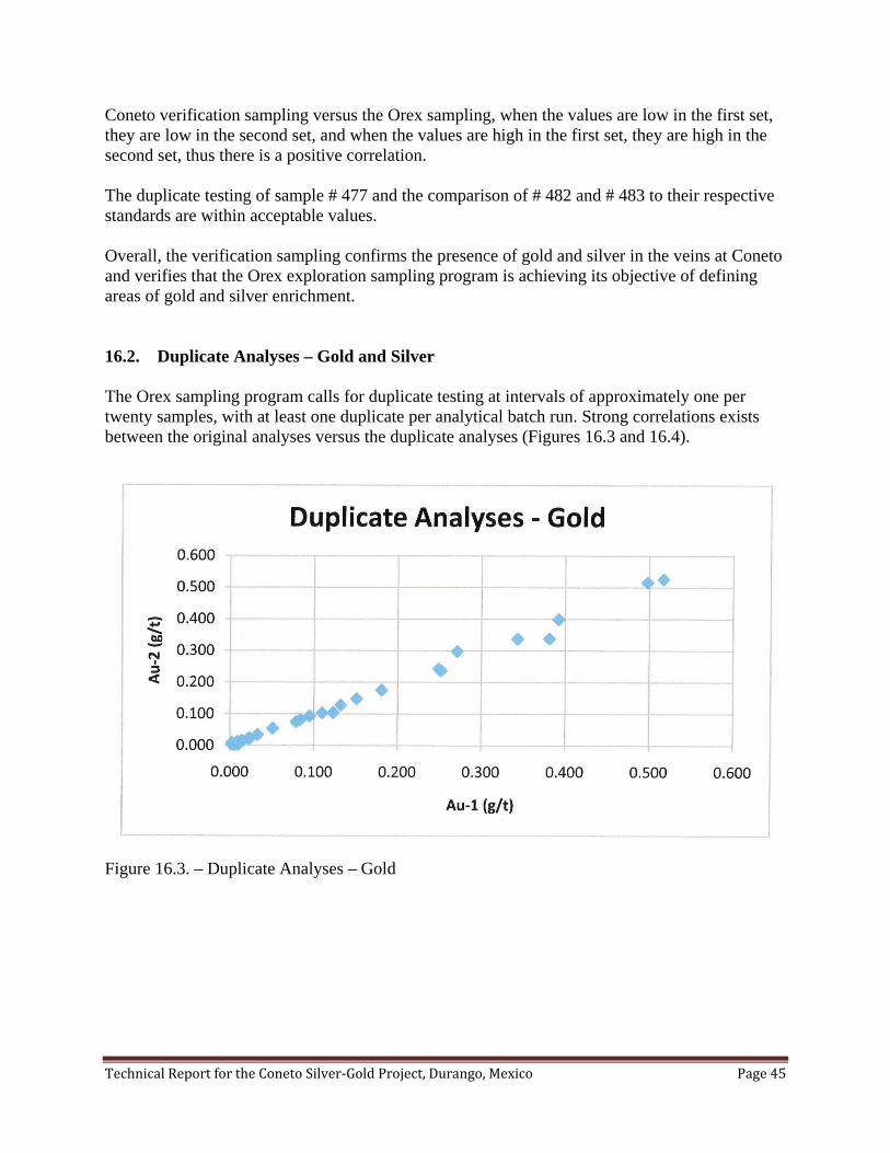
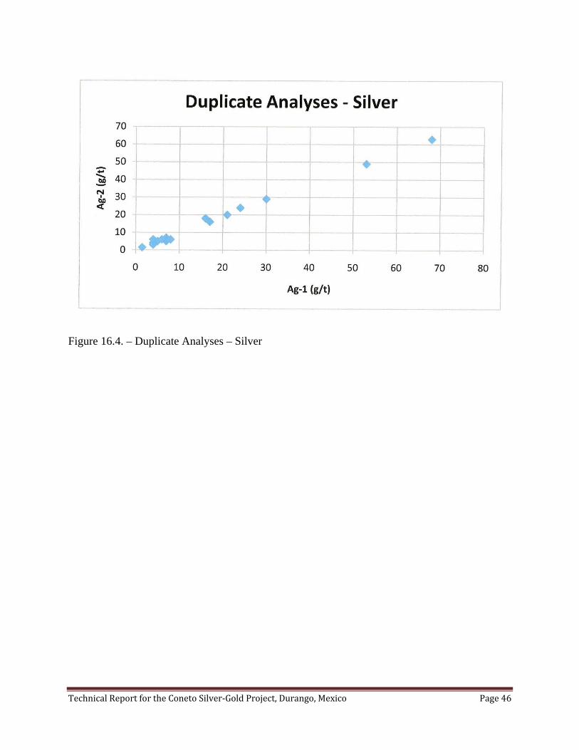
Coneto verification sampling versus the Orex sampling, when the values are low in the first set, they are low in the second set, and when the values are high in the first set, they are high in the second set, thus there is a positive correlation. The duplicate testing of sample # 477 and the comparison of # 482 and # 483 to their respective standards are within acceptable values. Overall, the verification sampling confirms the presence of gold and silver in the veins at Coneto and verifies that the Orex exploration sampling program is achieving its objective of defining areas of gold and silver enrichment. 16.2. Duplicate Analyses – Gold and Silver The Orex sampling program calls for duplicate testing at intervals of approximately one per twenty samples, with at least one duplicate per analytical batch run. Strong correlations exists between the original analyses versus the duplicate analyses (Figures 16.3 and 16.4).
Figure 16.3. – Duplicate Analyses – Gold
Technical Report for the Coneto Silver-Gold Project, Durango, Mexico Page 46
Figure 16.4. – Duplicate Analyses – Silver

Technical Report for the Coneto Silver-Gold Project, Durango, Mexico Page 47
17. ADJACENT PROPERTIES Information on Adjacent Properties is included herein as an illustration of the mineral endowment of the region from an exploration viewpoint. These properties are not included in the boundaries of the Coneto Property as defined in this technical report. While the authors have no reason to doubt the validity of any resource estimates presented below for adjacent properties, as quoted from publically disclosed references, the following cautionary statement is required as per NI43-101, F1, Item 17(c). The authors have not personally verified the information on all adjacent properties and this information is not necessarily indicative of mineralization on the Coneto Property. The immediately adjacent properties include four separate mineral concession blocks owned by Exploraciones La Parreña (part of the Peñoles group), consisting of about 1,975 hectares, which are totally enclosed within Orex blocks. Like many of Peñoles holdings across Mexico, no public records are available on exploration testing and it is believed that no recent work has been done on these mineral concessions. It is interpreted that the Indio and Promontorio Sur veins extend onto this ground. On the western side of the camp, about 2.5 km west of the village of Coneto de Comonfort, is the location of the small Naga Nega mineral concessions. Three small historic mine workings are present on narrow structures striking 170o and dipping 60o to 75o to the west. No significant production has come from these workings. The veins are hosted in Lower Volcanic Group, close to the contact with the Upper Volcanic Group, and represent the upper zone of a vein system. Argillic alteration and fragments of quartz can be followed on surface for about 400 m (Davila, 2009). Five kilometres to the southwest of the village of Coneto de Comonfort, in the Sierra de Coneto, are located a series of old prospects for tin, hosted in the Upper Volcanic Group. Narrow vein, high grade cassiterite SnO2 occurrences were discovered in the 1800s (Anon, 1888) and were worked briefly in the 1940s. The type locality for the mineral Durangite NaAl(AsO4)F was noted in rhyolite hosted tin occurrences in the Barranca Tin Mine, Sierra de Coneto area (Anon., 2009; Oakman et al., 1984; Palache et al., 1951). El Castillo gold mine (also known as El Cairo) is located about 25 km southeast of Coneto. This is an operating open-pit gold mine by Castle Gold Corporation, producing approximately 50,000 ounces per year. Low-sulphidation epithermal gold mineralization is hosted in silicified, argillized and pyritized mantos within volcaniclastics of the Lower Volcanic Group and adjacent dacitic sills (Leroux et al., 2008). As of 31 July 2008, Measured and Indicated resources stood at 94 million tonnes grading Au 0.39 g/t for a total of 1.18 million ounces. There is a further Inferred resource of 4.5 million tonnes grading Au 0.38 g/t for 55,000 ounces. These resources were based on an economic cut-off of Au 0.15 g/t and a price of $US 625/oz. San Agustin deposit of Silver Standard Resources Inc. is located in the San Lucas de Ocampo mining camp, about 25 km south-southeast of Coneto. This deposit, which was recently explored by Geologix Explorations Inc., hosts stockwork and disseminated gold-silver-lead-zinc
Technical Report for the Coneto Silver-Gold Project, Durango, Mexico Page 48
mineralization primarily in a dacitic dome complex. A total of 264 holes have been drilled on the property. An Indicated resource has been estimated to contain 121.0 million tonnes grading Au 0.41 g/t, Ag 12.3 g/t, Zn 0.49 % and Pb 0.06 % (2.39 million ounces Au-Eq). Inferred resources total 91.2 million tonnes grading Au 0.36 g/t, Ag 12.6 g/t, Zn 0.48 % and Pb 0.07 % (1.67 million ounces Au-Eq) (Arseneau, 2009). Just south of the San Agustin deposit, about 27 km south-southeast of Coneto, is the original San Lucas de Ocampo area. A shear zone extends over 4 km, with steeply dipping quartz-calcite veins bearing gold-silver-zinc-lead in Tertiary andesites of the lower Volcanic Group and underlying Cretaceous sedimentary units (Christopher, 2003). There is no known resource estimate for San Lucas de Ocampo, however, Oremex Resources Inc. currently has an exploration program planned for this camp. Tejamen Mining Camp is located in Nuevo Ideal, about 40 km west of the Sierra de Coneto and Laguna de Santiaguillo. Epithermal veins and shears of Ag, Au, Pb, Zn and Cu are hosted by Tertiary andesites and breccias, plus rhyodacite intrusive. It has been recently explored by Oremex Resources Inc., who on April 13, 2006 released a resource estimate of 50.8 million ounces silver-equivalent from 22.6 million tonnes grading 65.4 g/t Ag and 0.03 g/t Au for a silver-equivalent grade of 69.8 g/t (Garcia-Reyes, 2009; Palmer et al., 2006; Tribe, 2005). Note: Au-Eq, gold-equivalent, is determined by the gold content plus one-sixtieth of the silver content. Ag-Eq, silver-equivalent, is determined by the silver content plus sixty times the gold content. The 10-year running average (2000-2010) of gold and silver prices is 60 to 1 for the London Metal Exchange. For the purposes of Au-Eq and Ag-Eq, precious metal recovery is assumed to be 100%. Base metals and fluorite values are not included.

Technical Report for the Coneto Silver-Gold Project, Durango, Mexico Page 49
18. MINERAL PROCESSING AND METALLURGICAL TESTING Orex Minerals Inc. has not yet conducted mineral processing and/or metallurgical testing on the Coneto project.

Technical Report for the Coneto Silver-Gold Project, Durango, Mexico Page 50
19. MINERAL RESOURCE AND MINERAL RESERVE ESTIMATES There are no “current” NI43-101 compliant resources and/or reserves estimates for the Coneto Project, estimated after 1 February 2001.

Technical Report for the Coneto Silver-Gold Project, Durango, Mexico Page 51
20. OTHER RELEVANT DATA AND INFORMATION The authors are aware that the exploration program on Coneto is ongoing. Further geological mapping and surface sampling are being conducted adjacent to and within the boundaries of the property, the results of which will be presented in news releases by Orex. There are no other relevant data which would materially affect the results of this study.

Technical Report for the Coneto Silver-Gold Project, Durango, Mexico Page 52
21. INTERPRETATION AND CONCLUSIONS Coneto is a Tertiary aged intermediate sulphidation epithermal gold-silver mining camp, which has been under-explored. The corridor of mineralization exceeds 15 km northwest-southeast and has multiple sub-parallel structures over a width of approximately 4 km. Mineralogically, the exposures are interpreted to be high in the epithermal system. Historic exploitation of veins has been for narrow high-grade shoots in the upper 100 metres. Comparisons to other mining camps of this type in Mexico indicates a favourable horizon of precious metal mineralization may be vertically in the order of 400 to 600 metres, transitioning down to a base metal root system. Thus, less than 20% of the potential on any of the veins has been tested. There are over 40 known quartz veins on the property, many with adjacent breccias and stockwork zones. Surface structural mapping and sampling has confirmed that these are extensive mineralized systems. Independent verification sample testing supports the validity of the 2009 Orex exploration program results. There are three categories of exploration targets at Coneto:
4. High-grade gold and silver ore shoots similar to the historic mining (e.g. projections of Sauce and Palma ore shoots);
5. At or near surface low-grade bulk tonnage open pit zones (e.g. Promontorio, Calaveras); 6. Deep seated, flat-lying unconformity controlled mineralization at the contact between the
Cretaceous sedimentary units and the Tertiary volcanic (e.g. neighbouring La Preciosa and La Pitarrilla deposits).
Orex’s current exploration program has focused on surface structural mapping and sampling in order to guide a proposed diamond drilling program. At the time of writing, results from 668 assay samples had been evaluated, with gold grades varying between trace to 5.97 g/t and silver from trace to 436 g/t. The authors conclude that the exploration program sampling density and data reliability are suitable for the purpose of delineating mineralized structures as exploration drilling targets. Continued surface exploration and diamond drilling is warranted at Coneto.
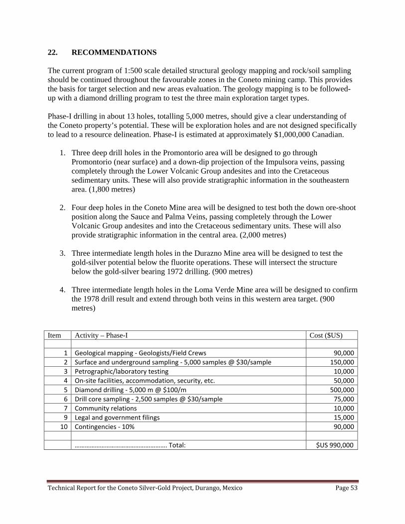
Technical Report for the Coneto Silver-Gold Project, Durango, Mexico Page 53
22. RECOMMENDATIONS The current program of 1:500 scale detailed structural geology mapping and rock/soil sampling should be continued throughout the favourable zones in the Coneto mining camp. This provides the basis for target selection and new areas evaluation. The geology mapping is to be followed-up with a diamond drilling program to test the three main exploration target types. Phase-I drilling in about 13 holes, totalling 5,000 metres, should give a clear understanding of the Coneto property’s potential. These will be exploration holes and are not designed specifically to lead to a resource delineation. Phase-I is estimated at approximately $1,000,000 Canadian.
1. Three deep drill holes in the Promontorio area will be designed to go through Promontorio (near surface) and a down-dip projection of the Impulsora veins, passing completely through the Lower Volcanic Group andesites and into the Cretaceous sedimentary units. These will also provide stratigraphic information in the southeastern area. (1,800 metres)
2. Four deep holes in the Coneto Mine area will be designed to test both the down ore-shoot position along the Sauce and Palma Veins, passing completely through the Lower Volcanic Group andesites and into the Cretaceous sedimentary units. These will also provide stratigraphic information in the central area. (2,000 metres)
3. Three intermediate length holes in the Durazno Mine area will be designed to test the gold-silver potential below the fluorite operations. These will intersect the structure below the gold-silver bearing 1972 drilling. (900 metres)
4. Three intermediate length holes in the Loma Verde Mine area will be designed to confirm the 1978 drill result and extend through both veins in this western area target. (900 metres)
Item Activity – Phase-I Cost ($US)
1 Geological mapping - Geologists/Field Crews 90,000 2 Surface and underground sampling - 5,000 samples @ $30/sample 150,000 3 Petrographic/laboratory testing 10,000 4 On-site facilities, accommodation, security, etc. 50,000 5 Diamond drilling - 5,000 m @ $100/m 500,000 6 Drill core sampling - 2,500 samples @ $30/sample 75,000 7 Community relations 10,000 9 Legal and government filings 15,000
10 Contingencies - 10% 90,000 ………………………………………………. Total: $US 990,000

Technical Report for the Coneto Silver-Gold Project, Durango, Mexico Page 54
Following a successful Phase-I drilling program, a second phase drilling program would then be recommended. Phase-II would be focused in the area of best results from Phase-I drilling. Its design will be to delineate a “first resource estimate” for Coneto. Similar dollar values will be required for a Phase-II program.
Technical Report for the Coneto Silver-Gold Project, Durango, Mexico Page 55
23. REFERENCES Anon., 2009, Durangite mineral data. Website <http://webmineral.com/data/durangite.shtml> Anon., 2007, Investigaciones metalurgicas pruebas de cianuracion por muestra Coneto No.5. Plata Panamericana S.A. de C.V., Division Mina La Colorada. Anon., 1996, A detailed structural analysis of the Coneto de Comonfort District, Durango. by ERA-Maptec Limited for Compañia Minera Mexicana de Avino S.A. de C.V., 53 p. Anon., 1888, Another alleged tin mine. The New York Times, published July 30, 1888. Aranda-Gomez, J.J., Henry, C.D., Luhr, J.F. and McDowell, F.W., 2003, Cenozoic volcanic-tectonic development of northwestern Mexico – A transect across the Sierra Madre Occidental volcanic field and observations on extension-related magmatism in the southern Basin and Range and Gulf of California tectonic provinces, in Geologic transects across Cordilleran Mexico, Guidebook for field trips of the 99th Annual Meeting of the Cordilleran Section of the Geological Society of America, Mexico D.F., March 25-30 2003, Universidad Nacional Autonoma de Mexico, Instituto de Geologia, Publicacion Especial I, fieldtrip 5, p. 71-121. Arseneau, G., 2009, San Agustin resource estimate. By Wardrop Engineering Inc. for Silver Standard Resources Inc. 60 p. Bravo-Campos, E., 2009, Lotes conocidos colectivamente como “Lomas” y “Coneto”, Proyecto Coneto. Legal title opinion, Lic. Juan Bravo Cuevas y Asociados, 3 p. Buchanan, L.J., 1981, Precious metal deposits associated with volcanic environments in the Southwest, in Relations of tectonics to ore deposits in the Southern Cordillera by W. Dickenson and W.Payne (editors), vol. XIX, p. 237-262. Cardenas-Vargas, J. (editor), 1993, Region Minera Coneto de Comonfort. in Monografia Geologico-Minera del Estado de Durango, Consejo de Recursos Minerales, Publicacion M-10e, p. 149-152. Christopher, P.A., 2003, Technical report on the San Lucas silver property, Diez de Octubre, San Lucas de Ocampo, Durango State, Mexico. for Blackhorn Gold Mines Ltd., 30 p. Corbett, G., 2002, Epithermal gold for explorationists. Australian Institute of Geoscientists, paper 2002-01, 39 p. Davila, M., 2009, Visit to the Naga Nega claims. Property examination memo, Orex Minerals Inc., 01 July 2009. Davila, M., and Betancourt, J., 2009, Coneto Project Durango Mexico – Progress Reports. Orex Minerals Inc., October 2009. (plus maps)

Technical Report for the Coneto Silver-Gold Project, Durango, Mexico Page 56
Durning, W.P., and Hillemeyer, F.L., 1999, Follow-up reconnaissance report – Coneto de Comonfort District, Durango. La Cuesta International Inc. Mexico Exploration for Crown Resources Corporation, 6 p. Durning, W.P., and Hillemeyer, F.L., 1994, Reconnaissance summary – Coneto de Comonfort Mining District. La Cuesta International Inc. Mexico Exploration for Monarch Resources, 7 p. Ewert, W., Puritch, E., Armstrong, T. and Yassa, A., 2008, Technical report and resource estimate on the La Pitarrilla property, Breccia Ridge deposit, Durango, Mexico. P&E Mining Consultants, for Silver Standard Resources Inc., 134 p. Garcia-Reyes, A.E., 2009, Evaluation report of the project “El Ideal, Nuevo Ideal, State of Durango, Mexico”. consulting report for Guillermo Arce Sánchez, 8 p. Gemmel, J.B., Simmons,S.F. and Zantrop, H., 1988, The Santo Niño Silver-Lead-Zinc Vein, Fresnillo District, Zacatecas, Mexico: Part I. Structure, Vein Stratigraphy, and Mineralogy, in Economic Geology, Volume 83, p. 1597-1618. Gunning, D.R., and Whiting, B.H., 2006, Technical Report – Mineral Resource Estimate on La Preciosa silver-gold deposit, Durango State, Mexico. Orko Gold Corporation, 49 p. (plus maps) – sedar dated 4 March 2006. Guzman, E., and Alba, L., 1981, Informe final de los trabajos de exploracion evaluative en el districto minero de Coneto de Comonfort, Durango. (Final report of the exploration evaluation work in the mining district of Coneto de Comonfort, Durango). Consejo de Recursos Minerales, Sigma-CRM Ti-100299, 217 p. Leroux, D.C., Watts, G., and Roy, W.D., 2008, Technical report on the El Castillo gold project, Durango, Mexico. by A.C.A. Howe International Limited for Castle Gold Corporation, 91 p. Lomelin, J., 2008, The Fresnillo Story, presented at Reacting to the New Volatility Paradigm, RBC Capital Markets Silver Conference, New York, December 16, 2008. McAra, J., Ewert, W.D., Armstrong, T.J., Ruijter, M.A., Puritch, E., Iakovlev, I., Ozturk, H., Vicentijevic, M., Friedman, D., Mercer, R.A., Wells, P. and Cowie, S., 2009, NI 43-101 Technical Report – Pitarrilla property pre-feasibility study. for Silver Standard Resources Inc. by Wardrop Engineering Inc., 251 p. McCrea, J.A., 2007, Technical report on La Pitarrilla property, Durango, Mexico. Silver Standard Resources Inc., 324 p. Megaw, Peter, 2008, Geologic Framework, Ore Deposits and Exploration of the Fresnillo Trend, Zacatecas Mexico, in Technical Session Abstract Book, Mining for a Minerals Dependant World, Northwest Mining Association 114th Annual Meeting, Reno, Nevada, USA, December 2008, p.16.

Technical Report for the Coneto Silver-Gold Project, Durango, Mexico Page 57
Monsivais, A. and Whiting, B.H., 2008, La Preciosa – Un yacimiento de plata en el norte de México. (La Preciosa – A silver deposit in the north of Mexico). 1er Congreso – Tendencias de la Actividad Minera en México, La Asociación de Ingenieros de Minas Metalurgistas y Geólogos de México, Durango, 4-6 September 2008. Oakman, M. R., Foord, E. E., and Maxwell, C. H., 1984, Durangite from the Black Range, New Mexico, and Coneto, Durango, Mexico (abs.): Mineralogical Society of America, symposium. Palache, C., Berman, H., and Frondel, C., 1951, The System of Mineralogy of James Dwight Dana and Edward Salisbury Dana, Yale University 1837-1892, Volume II. John Wiley and Sons, Inc., New York, 7th edition, revised and enlarged, 1124 pp.: 830. Palmer, K., Maunula T., and Nichols, A., 2006, Technical report on the Tejamen silver property, Durango State, Mexico. Wardrop Engineering Inc. for Oremex Resources Inc., 110 p. Pinto, J., 1998, Informe sobre el trabajo efectuado en la Mina de Coneto del 26 de Octubre al 07 de Noviembre de 1998. Cia. Minera San Miguel de Coneto S.A. de C.V., Unidad Coneto, 25 p. Ponce-Sibaje, B., 1978, Estudio geologic-geoquimico-estructural en apoyo a obras de exploracion en el districto minero Coneto de Comonfort, Dgo. Consejo de Recursos Minerales, gerencia de Estudios Especiales, Archivo Tecnico SIGMA-CRM TI-100116, 108 p. Puritch, E., and Yassa, A., 2008, Technical report and resource estimate on the La Pitarrilla property, Breccia Ridge deposit, Durango, Mexico. P&E Mining Consultants Inc. for Silver Standard Resources Inc., 186 p. Reyes-Cortes, I.A., 1985, Geology and uraniferous mineralization in the Sierra de Coneto, Durango, Mexico. Master of Geological Sciences thesis, The University of Texas at El Paso, 262 p. (plus maps). Ristorcelli, S., Ronning, P., Whiting, B., and Hawthorn, G., 2009, Technical report on the La Preciosa Project, Durango State, Mexico. Mine Development Associates for Orko Silver Corporation, 203 p. – sedar dated 31 March 2009. Veytia-Barba, M., 1974, Estudio geohidrologico del mineral de Coneto, Dgo. Comision de Fomento Minero, Mexico D.F., Sigma-CRM (Consejo Recursos Minerales – TI – 100061), 44 p. Vizcarra, J.M., 1996, Potencial estimado en las vetas del districto Coneto, 8 p. Whiting, B.H., 2009(a), Discovery and delineation of La Preciosa: A major epithermal silver-gold deposit in Durango, Mexico. Presentation and abstract in Open Session – Making the Grade, Prospectors and Developers Association, International Convention, Toronto, Canada, 1-5 March 2009 Whiting, B.H., 2009(b), Coneto de Comonfort silver-gold mining camp, Durango, Mexico. Property examination report, Orex Minerals Inc., 15 April 2009, 11 p.
Technical Report for the Coneto Silver-Gold Project, Durango, Mexico Page 58
Whiting, B.H., 2009(c), Conceptual exploration models for Coneto project, Durango, Mexico. Orex Minerals Inc., internal memorandum, 6 p.
Whiting, B.H., 2008(a), Technical report – mineral resource estimate V – La Preciosa silver-gold deposit, Durango State, Mexico. for Orko Silver Corporation, 75 p. (plus maps). – sedar dated 31 March 2008. Whiting, B.H., 2008(b), Orko’s La Preciosa: The discovery of a major epithermal silver-gold deposit in Durango, Mexico. Focus on Precious Metals Exploration in Mexico, Mining for a Minerals Dependent World, Technical session abstract book, Northwest Mining Association, Reno, Nevada, USA, p. 16-17 Whiting, B.H., 2007, Technical report – mineral resource estimate III – La Preciosa silver-gold deposit, Durango, Mexico. for Orko Silver Corporation, March 2007, 64 p. – sedar dated 31 March 2007. Whiting, B.H., 2006, Technical report – mineral resource estimate II – La Preciosa silver-gold deposit, Durango, Mexico. for Orko Silver Corporation, March 2007, 56 p. – sedar dated 5 September 2006. Whiting, B.H. and Gunning, D., 2007, Technical report – mineral resource estimate IV – La Preciosa silver-gold deposit, Durango, Mexico. for Orko Silver Corporation, October 2007, 68 p. (plus maps). – sedar dated 1 October 2007.
Whiting, B.H. and Monsivais, A., 2008, La Preciosa – An emerging silver-gold camp in northern Mexico. Mineral Exploration Roundup Conference, Association of Mineral Exploration, Vancouver, Canada, 28-31 January, Abstracts-08 Volume, p. 98-99.

Technical Report for the Coneto Silver-Gold Project, Durango, Mexico Page 59
24. DATE AND SIGNATURES PAGE The “Effective Date” of this Report, as per Item 24 of NI 43-101F1, is the 30thst day of November 2009, with revisions made on the 15th day of March 2010. Report signed this 15th day of March, 2010, in Vancouver, British Columbia, Canada.
/sig/ B.H. Whiting _______________________________ B. H. Whiting, P.Geo.
/sig/ D. R. Gunning _______________________________ D. R. Gunning, P.Eng. Specific Consent: - To the British Columbia Securities Commission: I, David R. Gunning, P.Eng., do hereby consent to the public filing of the Technical Report entitled “Technical Report for the Coneto Silver-Gold Project, Durango, Mexico” and dated 30 November 2009 (revised 15 March 2010) by Orex Minerals Inc., with the TSX Venture Exchange under the applicable policies and forms in connection with the Fundamental Acquisition announced in a news release dated 16 July 2009, to be entered into by the Issuer and I acknowledge that the Technical Report will become part of the Issuer’s public record.
/sig/ D. R. Gunning Signed: - D. R. Gunning, P.Eng. – 15 March 2010 I, Bernard H. Whiting, P.Geo., do hereby consent to the public filing of the Technical Report entitled “Technical Report for the Coneto Silver-Gold Project, Durango, Mexico” and dated 30 November 2009 (revised 1 March 2010) by Orex Minerals Inc., with the TSX Venture Exchange under the applicable policies and forms in connection with the Fundamental Acquisition announced in a news release dated 16 July 2009, to be entered into by the Issuer and I acknowledge that the Technical Report will become part of the Issuer’s public record.
/sig/ B.H. Whiting Signed: - B. H. Whiting, P.Geo. – 15 March 2010

Technical Report for the Coneto Silver-Gold Project, Durango, Mexico Page 60
CERTIFICATE OF QUALIFIED PERSON
To Accompany the Report titled "Technical Report for the Coneto Silver-Gold Project, Durango, Mexico”
for Orex Minerals Inc. dated November 30, 2009 (revised 15 March, 2010)
I, Bernard Henry (Ben) Whiting, of 427 Garrett Street, New Westminster, BC, Canada, Professional Geologist, do hereby certify that:
1. I am a graduate of the University of British Columbia and hold a Bachelor of Science
(B.Sc.) degree 1979 in Geological Sciences and a Master of Science (M.Sc.) degree 1989 in Geological Sciences.
2. I am a professional geologist and have practiced my profession on a full time basis in
Canada, USA, Mexico, Peru, Chile, Brazil, Venezuela, and elsewhere in South America, Europe, Asia and Oceania since 1979. I have also taught as an Adjunct Professor of geological sciences 1995-2006 and mining engineering 2000-2005 at Queen’s University and mining engineering 1989 at the University of British Columbia.
3. I have been a registered Professional Geoscientist (P.Geo.) member in good standing of the Association of Professional Engineers and Geoscientists of British Columbia (APEGBC) since 1991 and of the Association of Professional Geoscientists of Ontario (APGO) since 2002. I am also a Fellow of the Society of Economic Geologists (SEG) and a member of the Canadian Institute of Mining, Metallurgy and Petroleum (CIM) and La Asociación de Ingenieros de Minas Metalurgistas y Geólogos de México (AIMMGM).
4. I have read the definitions of “Qualified Person” set out in National Instrument 43-101 and certify that by reason of my education, affiliation with a professional association (as defined in NI 43-101) and past relevant work experience, I fulfill the requirements to be a “Qualified Person” for the purposes of NI 43-101.
5. I have conducted multiple site visits to the Coneto Project, Durango Mexico, the most recent visit being 2 November 2009.
6. I am an author responsible for all sections of this report utilizing data gathered in the field
in my role as Chief Geologist (Qualified Person) for Orex Minerals Inc. and information summarized in the references of this report.
7. I am not an “independent” Qualified Person with respect to Orex Minerals Inc. and all of its subsidiaries as defined in Section 1.4 of NI 43-101 and in Section 3.5 of the Companion Policy to NI 43-101.
Technical Report for the Coneto Silver-Gold Project, Durango, Mexico Page 61
8. I have read National Instrument 43-101, Companion Policy 43-101CP and Form 43-101F1 and this technical report has been prepared in compliance with that instrument.
9. To the best of my knowledge, information and belief, this technical report contains all the scientific and technical information that is required to be disclosed to make this technical report not misleading.
10. I consent to the filing of the Technical Report with any stock exchange and other regulatory authorities and any publication by them for regulatory purposes, including electronic publication in the company files on their websites accessible by the public.
/sig/ B.H. Whiting ______________________________ B. H. (Ben) Whiting, M.Sc., P.Geo. Dated at Vancouver, British Columbia this 15th day of December 2009.

Technical Report for the Coneto Silver-Gold Project, Durango, Mexico Page 62
CERTIFICATE OF QUALIFIED PERSON
To Accompany the Report titled "Technical Report for the Coneto Silver-Gold Project, Durango, Mexico”
for Orex Minerals Inc. dated November 30, 2009 (revised 15 March, 2010)
I, David R. Gunning of 20356 42A Avenue, Langley, B.C., Canada, Professional Engineer, do hereby certify that; 1. I am a graduate of the University of British Columbia (1983) and hold a B.A.Sc. degree
in Mining and Mineral Process Engineering (mining option).
2. I am presently self-employed as a consulting mining engineer.
3. I have been employed in my profession by various companies since graduation, and self-employed as an international consultant since 1996.
4. I am a registered Professional Engineer with Association of Professional Engineers and Geoscientists of British Columbia since 1989.
5. I have read the definitions of “Qualified Person” set out in NI 43-101 and certify that by
reason of my education, affiliation with a professional association and past relevant work experience, I fulfil the requirements to be a “Qualified Person” for the purposes of NI 43-101.
6. I visited the Coneto Project in Durango, Mexico, on 2 November 2009.
7. I am a co-author responsible for all sections of this report, as the independent qualified
person, utilizing data gathered in the field and information summarized in the references of this report.
8. I have performed other consulting services to Orex Minerals Inc. prior to the preparation of this report.
9. I am “independent” of Orex Minerals Inc. and all of its subsidiaries as defined in Section
1.4 of NI 43-101 and in section 3.5 of the Companion Policy to NI 43-101.
10. I have read NI 43-101, Companion Policy 43-101CP and NI 43-101F1 and have prepared the technical report in compliance with that instrument and form.
11. To the best of my knowledge, information and belief, this technical report contains all the scientific and technical information that is required to be disclosed to make this technical report not misleading.

Technical Report for the Coneto Silver-Gold Project, Durango, Mexico Page 63
12. I consent to the filing of the Technical Report with any stock exchange and other
regulatory authority and any publication by them for regulatory purposes, including electronic publication in the public company files on their websites accessible by the public, of the Technical report.
/sig/ D.R. Gunning ________________________________ David R. Gunning P. Eng.

Technical Report for the Coneto Silver-Gold Project, Durango, Mexico Page 64
25. ADDITIONAL REQUIREMENTS FOR TECHNICAL REPORTS ON DEVELOPMENT PROPERTIES AND PRODUCTION PROPERTIES Coneto is currently considered an advanced exploration project, thus is not considered to be a development or production property for the purposes of reporting under NI 43-101.
Technical Report for the Coneto Silver-Gold Project, Durango, Mexico Page 65
26. ILLUSTRATIONS Illustrations are inserted into the text of the report. No separate foldout illustrations are included. Figure 6.1 – Location Map Figure 6.2 – Mineral Concession Map Figure 8.1 – Metallurgy Recovery -200 Mesh Figure 9.1. – Geological Map – Central Area Veining Figure 11.1. – Main Veins in the Coneto Mining Camp. Figure 12.1. – Gold Isovalues in the Southeast Area Figure 12.2. – Silver Isovalues in the Southeast Area Figure 16.1 – Gold Verification Testing Figure 16.2 – Silver Verification Testing Figure 16.3. – Duplicate Analyses – Gold Figure 16.4. – Duplicate Analyses – Silver

Technical Report for the Coneto Silver-Gold Project, Durango, Mexico Page 66
APPENDIX “A”
LEGAL TITLE OPINION

Technical Report for the Coneto Silver-Gold Project, Durango, Mexico Page 67
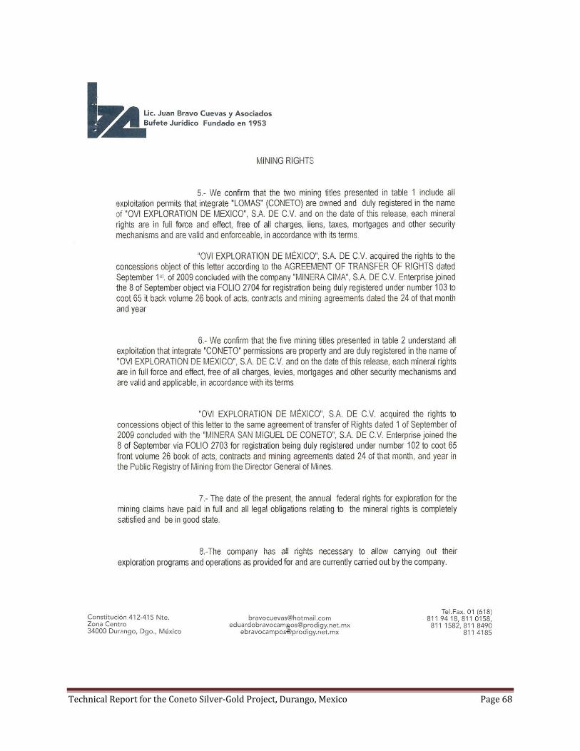
Technical Report for the Coneto Silver-Gold Project, Durango, Mexico Page 68

Technical Report for the Coneto Silver-Gold Project, Durango, Mexico Page 69


