56
Technical Specification for Khawr Kabir

Technical Specification for Khawr Kabir

TECHNICAL SPECIFICATION FOR KHAWR KABIR
Kabir-1
1. SITE DESCRIPTION
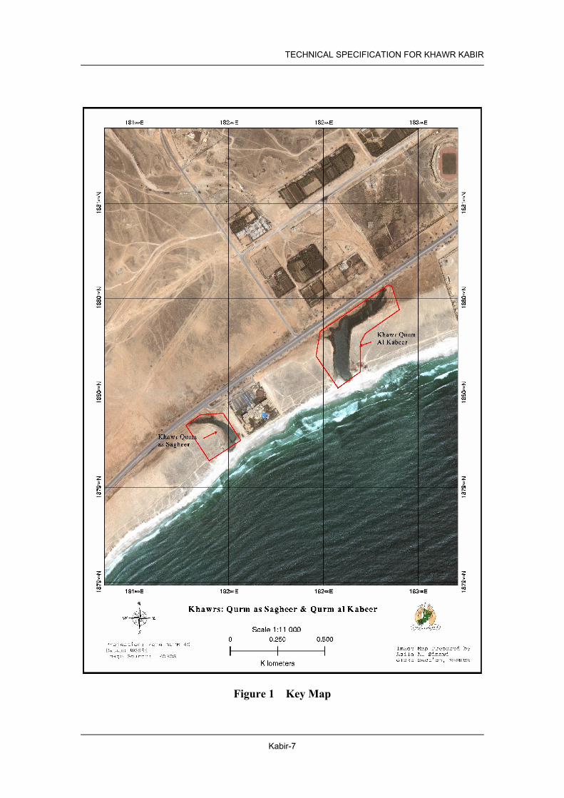
1.1 Location Governorate/ Region Dhofar Wilayat Salalah Distance from the Centre of Waylay
It is located approximately 10 km west of the city centre of Salalah.
Nearest Locality Salalah Fame of the Site/ Distinctive Features
None
Facilities in the Site Plant Nursery is in operation and taking a roll of seedling supply station for Regions near to Salalah.
Features of Surrounding Areas This Khawr is located 0.5 km east side of Hilton Salalah Hotel.
1.2 Natural Conditions Climate Zone Dhofar Zone General Terrain Flat plain Geological Features No data History of Geological Change In May 2002, a large cyclone produced floods around Salalah and
Khawr Kabir received floodwater, which broke through the sandbar. This lowered the water level and allowed seawater to enter at high tide. The sandbar is now rebuilt and the salinity of the water is about 2.4% (before it was about the same as seawater 3.4-3.7%) and is expected to gradually increase again as seawater enters during the khareef. During the flood the sand banks along the channel nearer the sea collapsed in places, killing some smaller mangroves. This also has the effect of widening the channel and small mangroves that had germinated along the previous waterline were now surrounded by water about 1 meter from the shore.
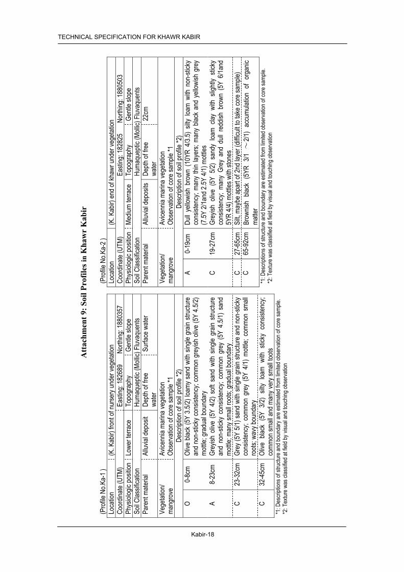
Soil Khawr Kabir lies on the flat plain located at east of Hilton Hotel in western part of Salalah. The khawr is cut off by short sandbar from sea. The soils of both sides at the mouth of khawr are deep sand. Also the narrow and sandy shore on the south of khawr is stretching to the place near mangrove nursery. On the other hand, the north shares of khawr are steep and sandy soils. The upper shores at both side of khawr are covered by mangrove. The soils under this vegetation are basically deep and silty with organic matter and humic substances. However, sandy soils are observed at surrounding areas adjacent to the mangrove vegetation. Many gravels and stones, which were carried by flooding, are recognized in the area of upper khawr. Details are shown in attached table “Attachment 4: Soil Profile in Khawr Kabir” and “Attachment 9: Soil Profile Samples in Khawr Kabir”
Water Salinities of water in khawr were 2.6% at the mouth and 2.9% at upstream in Jan 2003, and 2.0%. The values of COD were 5-10mg/l. DO on surface water on upper khawr showed relatively lower value (2.8mg/l) than khawr mouth (more than 7.2mg/l) in January 2003. But these values were decreased to 1.5mg/l at khawr mouth and 3.1mg/l on upper khawr. in May 2003. Green alga was found in surface water in khawr. Water quality was getting worse compare to the data on January 2003.

TECHNICAL SPECIFICATION FOR KHAWR KABIR
Kabir-2
Details are shown in attached table “Attachment 5: Surface Water Quality in Khawr Kabir”
Fauna Several large active holes of the land crab (Cardisoma carnifex) were found on the landward edge of the mangroves. Burrowing shrimp holes (Callichirus sp) were common (up to 400/m2) in open sandy areas covered by shallow water. A few holes of ghost crabs (Ocypode) were present. Sieved samples of sand near the mouth of the khawr behind the sandbar contained elements of marine (small mussels cf Musculista senhousia), estuarine (burrowing amphipods cf Corophium and small horn shells, Potamides conicus) and freshwater (chironomid larvae, Hydrobia snails) fauna. Mosquito larvae (Anopheles coustani) occurred in isolated pools. Small fish were abundant. Birds recorded in the winter were 1 moorhen, 1 little egret, 1 great white heron, waders (4 redshank, 1 wood sandpiper, 1 common sandpiper). In the summer, 10 night herons were counted roosting in the trees. These birds roost mainly in mangrove trees and are not normally found elsewhere. Compared with studies in 1993, the khawr had a greater freshwater component but diversity was high.
Flora Algae were recorded in the water (Chaetomorha crassa, Enteromorpha flexuosa). The main plant zone along the edges of the khawr was the grass, Sporobolus virginicus, which was joined by the reed, Phragmites australis, along the drainage channels at the landward side of the mangroves. Some patches of reed near the road gate showed signs of previous heavy grazing with the main stem eaten and numerous side branches bearing small spiky leaves. The vegetation of the drier sandy banks comprised the normal plant association for this zone (Suaeda vermiculata, Cyperus conglomeratus, Urochondra setulosa, Aeluropus lagopoides, Sporobolus spicatus, Cressa cretica, Heliotropium fartakense, Senra incana).
Impacts from the Surrounding Areas
None
1.3 Socio-economic Situation Population of the Wilayat (2001)
162 thousand
Population of the Nearest Locality (1993)
162 thousand
Main Economic Activities Tourism, industry Infrastructure All utility and infrastructure available. Highway passing through beside
the site. The mangroves of Khawr Kabir were fenced in 2002 to allow the trees to recover from overgrazing by camels.
Main Usage No distinctive activities and utilization except for plant nursery established by MRMEWR in cooperation with JICA expert.
Community Interference with the Area
Residential and commercial development will encroach the area.
Cultural Significance None

TECHNICAL SPECIFICATION FOR KHAWR KABIR
Kabir-3
1.4 Legal Setup and Development Plans Land Ownership and Land Use Designation
The Khawr was designated as a Nature Reserve by Royal Decree Royal Decree 49/97 dated 28/6/97 with the Ministry of Regional Municipalities and Environment as the managing authority. The management plan aims to protect the mangrove trees while allowing controlled access for fodder collection. Sustainable fishing and the use of the area as a picnic site would also be allowed.
Development Plans in the Site and the Surrounding Area
N/A
Existing Conservation Proposal
Declared as nature reserve in 1997
2. PROGRAMME AND PROJECT
2.1 Prerequisite Legal Setup for Land Use Control
Set a distinct boundary of NR (see 4.2 Required Action for Conservation and Management) and building regulation of surrounding area.
Facility Development Control No permanent structure in NR, except hide for bird watching, sign and information boards, and board walking or pedestrian bridge. Footpath should be designated but not paved. No permanent commercial buildings such as restaurants hotels shops and mechanized amusement facilities in the park development area. Basic activities in this park are relaxation and picnicking. Partial lighting for safety only. Utilities lines (water and electricity should be minimum) and setback 150 m from the edge of Mangrove.
2.2 Description of Programmes Facility Development Programme
N/A
Restoration and Afforestation Programme
N/A
Monitoring Programme (1) Mangrove monitoring project (2) Soil and water monitoring project (3) Fauna and flora monitoring project (4) Pollution monitoring project (5) Monitoring project on legal setup and development plans
Public Awareness Programme It will include an educational programme for school children and conservation campaign for residents of the Wilayat. Required materials and facilities are (6) Pamphlets and posters distributed to the residents, (7) Information boards describing significance of the natural environment.

TECHNICAL SPECIFICATION FOR KHAWR KABIR
Kabir-4
2.3 Implementation Mechanism Projects Responsible
Agencies Implementing
Body/ Agencies
Related Agencies
(1) Mangrove Monitoring Project MRMEWR Wylayat Salalah (2) Soil and Water Monitoring Project MRMEWR Wylayat Salalah (3) Fauna and Flora Monitoring Project MRMEWR MRMEWR/
Omani Institute for Birds
(4) Pollution Monitoring Project MRMEWR Waylay Salalah/ MRMEWR
(5) Monitoring Project on Legal Setup and Development Plans MRMEWR Wylayat Salalah (6) Pamphlets and posters distributed to the residents MRMEWR MRMEWR MOE (7) Information boards MRMEWR MRMEWR MOE
2.4 Implementation Schedule Project
No. 1 st 2 nd 3 rd 4 th 5 th 6th 7th 8th 9 th 10 th
(1) (2) (3) (4) (5) (6) (7)
3. IMPLEMENTATION PLAN
3.1 Restoration and Afforestation
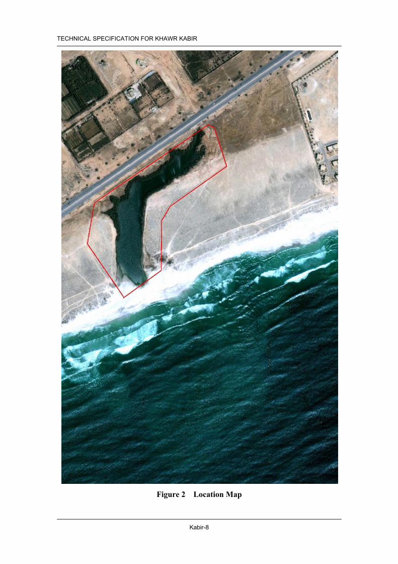
3.1.1 Existing Mangrove Area Location and Area Both shores surrounding Khawr Kabir covered by mangrove area is 4.2
ha approximately. (Figure 2 Location Map) Conditions of Existing Mangrove
Healthy and tall mangrove trees are lushly surviving on both banks at the upper khawr. Tall trees reached more than 10m heights. Many falling trees due to last flooding are observed. Before fencing, grazing by camels was severe. Many new branches from grazing branches are developing. Many seeds are observed after flowering season. New seedlings have planted by MRMEWR at the northern shore of khawr mouth (1500m2), southern narrow shore and shore of inmost khawr in January 2003. Most of planted trees are growing well. Much garbage at inmost khawr. No more grazing by camels due to fencing.

TECHNICAL SPECIFICATION FOR KHAWR KABIR
Kabir-5
3.1.2 Plantation Area Tidal Condition Normal: mouth is closed Wave and Wind Calm in Winter, Drifted sand damages seaward fringe. Flood Every 5 to 10 years Water Salinity and PH Salinity; 2.6 ~ 2.9 %, PH; – 7.5 ~ 7.9 (“Attachment 5: Surface
Water Quality in Khawr Kabir”) Soil Conditions Sandy soil with aerobic condition. Surveyed data is in the “Attachment
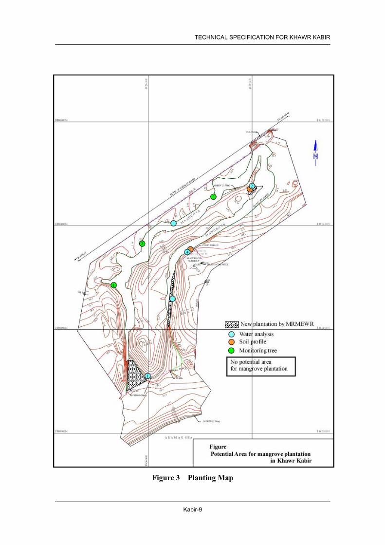
4: Soil Profile in Khawr Kabir” of this technical specification. Potential Area N/A
Table 3.1 Location and Areas of Potential Planting Area(s)
Designated Area Area (ha) Area-1 No plantation
3.1.3 Conservation Area Area of Land Use Nature Reserve (NR) Area
3.1.4 Required Action for Conservation and Management Inspection Daily observation by the management body, 2 to 3 times of inspection
by MRMEWR (Mangrove Information Centre) Cleaning Management Body Replantation of Seedlings Growing Bad, Dead or Washed Away
MRMEWR (Mangrove Information Centre) for 5 years after plantation.
Service for Associated Facilities Regularly by Management Body Patrol and Enforcement Daily ordinary patrol by a police office of Wilayat is required, and the
management body regularly inspects facilities conditions and littering and waste disposal to the ground and water in NR areas.
Restoration and Rehabilitation Work
The mangrove plantation work in the planting area described in the previous section is necessary.
Facilities Required for the Conservation and Management Activities
Direction signs along the highway and entrance to the access road(s), guide signs in the reserve, and information boards in the NR area can be seen in the area to explain the significance of the reserve and major flora and fauna. Footpath and boardwalk for observation of wild life as well as mangrove are also necessary.
3.2 Monitoring
3.2.1 Mangrove Monitoring Method Existing mangrove:
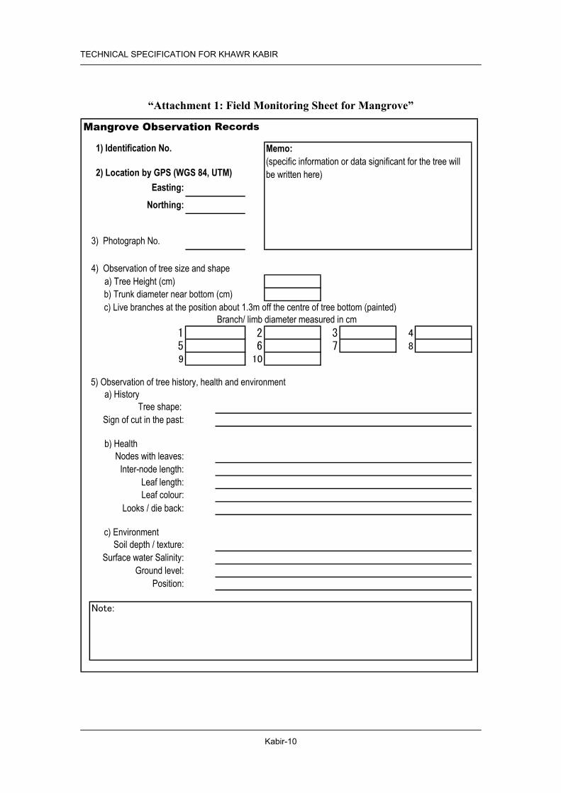
Label trees for monitoring. Monitor mangrove by using the attached “Attachment 1: Field Monitoring Sheet for Mangrove”.
Mangrove planted: First 4 years: tree height, canopy X:Y After 4 years: follow monitoring sheet
Frequency Existing mangrove: Every 2 years

TECHNICAL SPECIFICATION FOR KHAWR KABIR
Kabir-6
Mangrove planted: First 4 year: annual monitoring After 4 year: every 2 year
Monitoring Target Existing mangrove: 1) Kb-OT2: Coordinate Easting 182547 /Northing 1880283 2) Kb-OT3: Coordinate Easting 182580 /Northing 1880358 3) Kb -OT4: Coordinate Easting 182716 /Northing 1880457 Mangrove planted: Select 20 trees at random and monitor them.
Baseline Data Baseline data and monitoring trees are listed in “Attachment 2: List of the Observed Points in Khawr Kabir”.
3.2.2 Soil and Water Monitoring Method Monitoring soil and water in and around mangrove vegetation by
using attached table “Attachment 3: Field Monitoring Sheet for Soil and Water (Khawr Kabir)”
Frequency Soil: (Mangrove planted area) Every 2 year (Existing mangrove area) Every 2 Year Water; Before (Apr) and after (Nov) monsoon season (Every year) (Outflow water at low tide should be measured.)
Monitoring Target Attachment 3 Baseline Data See attached table “Attachment 4: Soil Profile in Khawr Kabir”
and “Attachment 5: Surface Water Quality in Khawr Kabir”
3.2.3 Fauna and Flora Monitoring Method Monitor fauna and flora by using the attached “Attachment 6: Field
Monitoring Sheet for Fauna and Flora and Pollution.” For the observation of birds, an institute that is studying birds in Oman can be the best institute to take a part of the monitoring work by sub-contract base.
Frequency At least twice a year Monitoring Target Attachment 6 Baseline Data The result of field reconnaissance of flora and fauna is shown in
“Attachment 7: Result of Field Reconnaissance of Flora and Fauna in Khawr Kabir”
3.2.4 Pollution (garbage and waste) Monitoring Method Monitor pollution by using the attached “Attachment 6: Field
Monitoring Sheet for Fauna and Flora and Pollution.” Water Quality and Soil Sample Tests should be carried out by MRMEWR.
Frequency At least twice a year Monitoring Target Attachment 6 Baseline Data See “Attachment 7: Result of Field Reconnaissance of Flora and
Fauna in Khawr Kabir”
3.2.5 Change on Legal Setup and Development Plans Frequency At least once a year
Monitoring Target Any changes on legal situation of the site should be recorded. Land Ownership, Land Use Designation, Development Plans in the Site and Surrounding Area
TECHNICAL SPECIFICATION FOR KHAWR KABIR
Kabir-7
Figure 1 Key Map
TECHNICAL SPECIFICATION FOR KHAWR KABIR
Kabir-8
Figure 2 Location Map
TECHNICAL SPECIFICATION FOR KHAWR KABIR
Kabir-9
Figure 3 Planting Map
TECHNICAL SPECIFICATION FOR KHAWR KABIR
Kabir-10
“Attachment 1: Field Monitoring Sheet for Mangrove”
Mangrove Observation Recors
1) Identification No.
2) Location by GPS (WGS 84, UTM)Easting:
Northing:
3) Photograph No.
4) Observation of tree size and shape a) Tree Height (cm)b) Trunk diameter near botto m (cm)C) Live branches at the position about 1.3m off the center of tree bottom (painted)
Branch/ limb diameter measured in cm1 2 3 4
5 6 7 8
9 10
5) Obsrevation of tree history, helth and environmenta) History
Tree shape: Sign of cut in the past:
b) Health Nodes with leaves:
Inter-node length:Leaf length:Leaf color:
Looks / die back:
C) EnvironmentSoil depth / texture:
Surface water Salinity:Ground level:
Position:
Note:
Memo:(specific information or data significant for the tree willbe written here)
Records
b) Trunk diameter near bottom (cm) c) Live branches at the position about 1.3m off the centre of tree bottom (painted)
5) Observation of tree history, health and environment
c) Environment
Leaf colour:

Kabir-11
TECHNICAL SPECIFICATION FOR KHAWR KABIR
“Att
achm
ent 2
: Lis
t of t
he O
bser
ved
Poin
ts in
Kha
wr
Kab
ir”
12
34
56
78
910
Kab
irK
b-O
T11
22 D
ec '0
218
2547
1880
283
kabi
rtree
1a &
1b
994
2322
2310
197.
213
Kab
irK
b-O
T22
22 D
ec '0
218
2580
1880
358
kabi
rtree
2a &
2b
1084
3031
129.
47.
56.
55
mor
e de
ad b
ranc
hes
Kab
irK
b-O
T33
22 D
ec '0
218
2716
1880
457
kabi
rtree
3a &
3b
854
2035
2721
2 m
ore
dead
bra
nche
s
Kha
wr
Tre
eN
umbe
rM
onito
ring
Tre
es
Dat
e of
Obs
erva
tion
Rem
arks
East
ing
Nor
thin
gTr
unk
near
botto
m
Live
bra
nche
s at t
he p
ositi
on a
bout
1.3
m o
ff th
ece
nter
of t
ree
botto
m (D
BH
: Dia
met
er B
reat
h H
eigh
t)
Coo
rdin
ate
(UT
M)
Phot
o N
umbe
rH
eigh
t(c
m)
Dia
met
er (c
m)
Live
bra
nche
s at t
he p
ositi
on a
bout
1.3
m o
ff th
e ce
ntre
of t
ree
botto
m
(DB
H: D
iam
eter
Bre
ast H
eigh
t) O
bser
vatio
n

TECHNICAL SPECIFICATION FOR KHAWR KABIR
Kabir-12
“Attachment 3: Field Monitoring Sheet for Soil & Water (Khawr Kabir)”
Location Date / time: / ,200 : Recorder General Condition in plantation area:
(garbage, rubbish, leaf, alga, crab, shell, etc) (1) Soil Condition
Transplanted Mangrove① at west shore
Existing Mangrove ② dense forest at upper khawr
Easting 182570 182750 Coordinate Northing 1880010 1880480 Surface condition
0-10cm 30-40cm Soil
Texture 50-60cm 0-10cm
30-40cm Soil Colour 50-60cm
Root development Depth of surface humus
GWL* (cm) pH Free
water Salinity (%) Soil colour by Munsell notation, GPS*:by UTM of WGS84 GWL: Ground water level
(2) Surface Water Quality (Observation time: : ) Khawr mouth ③ Upper khawr ④ Sea Water ⑤
Easting 182630 181830 - Coordinate Northing 1880200 1880480 - Surface waste pH Salinity (%) Temperature (C) DO (mg/l) Turbidity / Colour
●Soil ○ Water
2 4
3 1
5 Location of monitoring

Kabir-13
TECHNICAL SPECIFICATION FOR KHAWR KABIR
“Att
achm
ent 4
: Soi
l Pro
file
in K
haw
r K
abir
”
“Att
achm
ent 5
: Sur
face
Wat
er Q
ualit
y in
Kha
wr
Kab
ir”
Easti
ngN
orth
ing
Dep
th(c
m)
pHSa
linity
(%)
Surfa
ce(0
-30c
m)
Sub-
surfa
ce(3
0-60
cm)
Dee
p la
yer
(>90
cm)
Surfa
ce (
0-30
cm)
Sub-
surfa
ce (3
0-60
cm)
Surfa
ceSu
b-su
rface
Ka-
1Fr
ont o
f nur
sery
und
er v
eget
atio
n18
2689
1880
357
Core
sam
ple,
unde
r sur
face
wat
erSa
ndy
-sa
ndSa
nd -
loam
Sand
Gra
yish
oliv
eG
ray
Soft
-
Ka-
2U
pstre
am o
f kha
wr u
nder
vege
tatio
n18
2825
1880
503
Core
sam
ple
Silty
loam
-cl
ay lo
amSi
lt-
orga
nic m
.
Dul
l yel
lowi
shbr
own
- gra
yish
oliv
e-
Har
d-
Dat
a of h
ardn
ess i
n pa
rent
hrsis
by
hand
obs
erva
tion
Soil
Colo
rH
ardn
ess
Prof
ileN
o.
Coor
dina
te (U
TM)
Gro
und
Wat
erTe
xtur
eLo
catio
nSo
il C
olou
r
Gre
yish
oliv
eG
rey
Dul
l yel
low
ish
brow
n -g
reyi
sh
oliv
e
Easti
ngN
orth
ing
1M
outh
of k
haw
r18
2634
1880
154
±7.
92.
621
.67.
205-
10-
2In
mos
t up
strea
m o
f kha
wr
1828
0418
8048
8+
7.5
2.9
21.4
2.80
5-10
-
3M
outh
of k
haw
r18
2598
1880
101
+7.
92.
030
.73.
10-
-4
Fron
t of n
urse
ry18
2710
1880
368
±7.
92.
031
.72.
30-
-
5In
mos
t up
strea
m o
f kha
wr
1828
2118
8050
5±
7.9
2.0
32.6
1.50
5-10
1<O
bser
vatio
n D
ate:
12-
14 Ja
nuar
y 20
03 fo
r sam
ple
No.
1-2,
31
May
200
3 fo
r sam
ple
No.
3-5
COD
(mg/
l)N
O3
(mgN
O3/
l)Co
lor/
Visi
bilit
ypH
Salin
ity(%
)Te
mpe
ra-
ture
(C)
No.
Coor
dina
te (U
TM)
Loca
tion
DO
(mg/
l)C
olou
r/V
isib
ility
Dat
a of
har
dnes
s in
pare
nthe
sis b
y ha
nd o
bser
vatio
n
TECHNICAL SPECIFICATION FOR KHAWR KABIR
Kabir-14
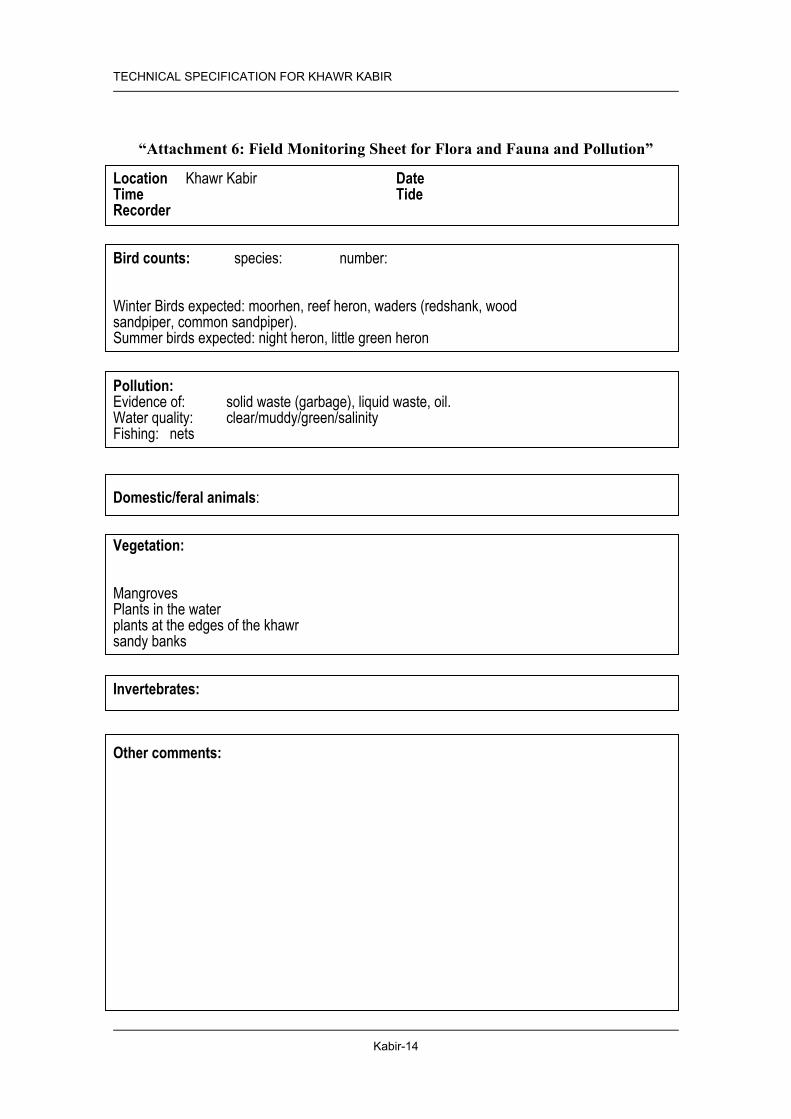
“Attachment 6: Field Monitoring Sheet for Flora and Fauna and Pollution”
Location Khawr Kabir Date Time Tide Recorder Bird counts: species: number: Winter Birds expected: moorhen, reef heron, waders (redshank, wood sandpiper, common sandpiper). Summer birds expected: night heron, little green heron Pollution: Evidence of: solid waste (garbage), liquid waste, oil. Water quality: clear/muddy/green/salinity Fishing: nets Domestic/feral animals: Vegetation: Mangroves Plants in the water plants at the edges of the khawr sandy banks Invertebrates: Other comments:
TECHNICAL SPECIFICATION FOR KHAWR KABIR
Kabir-15
“Attachment 7: Result of Field Reconnaissance of Fauna and Flora and Pollution in Khawr Kabir”
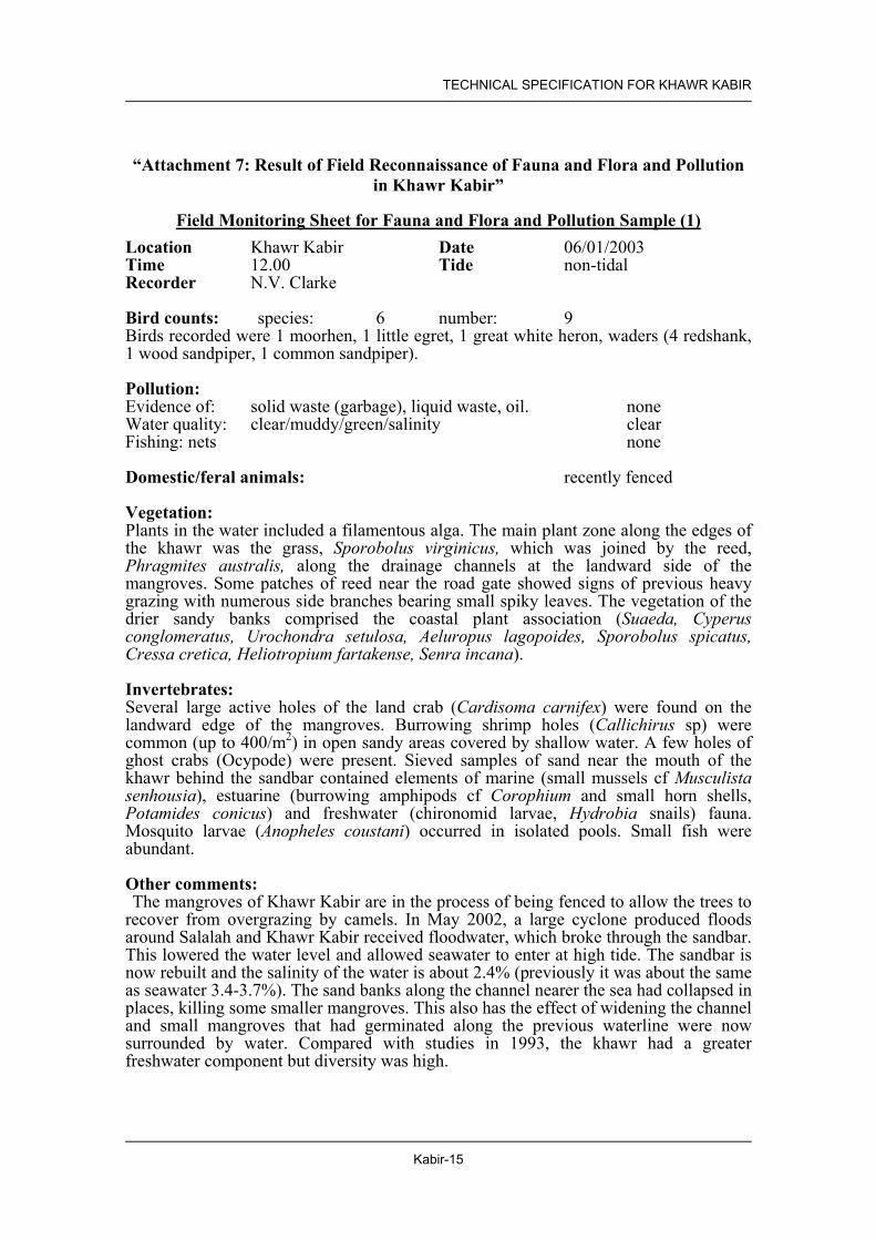
Field Monitoring Sheet for Fauna and Flora and Pollution Sample (1) Location Khawr Kabir Date 06/01/2003 Time 12.00 Tide non-tidal Recorder N.V. Clarke Bird counts: species: 6 number: 9 Birds recorded were 1 moorhen, 1 little egret, 1 great white heron, waders (4 redshank, 1 wood sandpiper, 1 common sandpiper). Pollution: Evidence of: solid waste (garbage), liquid waste, oil. none Water quality: clear/muddy/green/salinity clear Fishing: nets none Domestic/feral animals: recently fenced Vegetation: Plants in the water included a filamentous alga. The main plant zone along the edges of the khawr was the grass, Sporobolus virginicus, which was joined by the reed, Phragmites australis, along the drainage channels at the landward side of the mangroves. Some patches of reed near the road gate showed signs of previous heavy grazing with numerous side branches bearing small spiky leaves. The vegetation of the drier sandy banks comprised the coastal plant association (Suaeda, Cyperus conglomeratus, Urochondra setulosa, Aeluropus lagopoides, Sporobolus spicatus, Cressa cretica, Heliotropium fartakense, Senra incana). Invertebrates: Several large active holes of the land crab (Cardisoma carnifex) were found on the landward edge of the mangroves. Burrowing shrimp holes (Callichirus sp) were common (up to 400/m2) in open sandy areas covered by shallow water. A few holes of ghost crabs (Ocypode) were present. Sieved samples of sand near the mouth of the khawr behind the sandbar contained elements of marine (small mussels cf Musculista senhousia), estuarine (burrowing amphipods cf Corophium and small horn shells, Potamides conicus) and freshwater (chironomid larvae, Hydrobia snails) fauna. Mosquito larvae (Anopheles coustani) occurred in isolated pools. Small fish were abundant. Other comments: The mangroves of Khawr Kabir are in the process of being fenced to allow the trees to recover from overgrazing by camels. In May 2002, a large cyclone produced floods around Salalah and Khawr Kabir received floodwater, which broke through the sandbar. This lowered the water level and allowed seawater to enter at high tide. The sandbar is now rebuilt and the salinity of the water is about 2.4% (previously it was about the same as seawater 3.4-3.7%). The sand banks along the channel nearer the sea had collapsed in places, killing some smaller mangroves. This also has the effect of widening the channel and small mangroves that had germinated along the previous waterline were now surrounded by water. Compared with studies in 1993, the khawr had a greater freshwater component but diversity was high.

TECHNICAL SPECIFICATION FOR KHAWR KABIR
Kabir-16
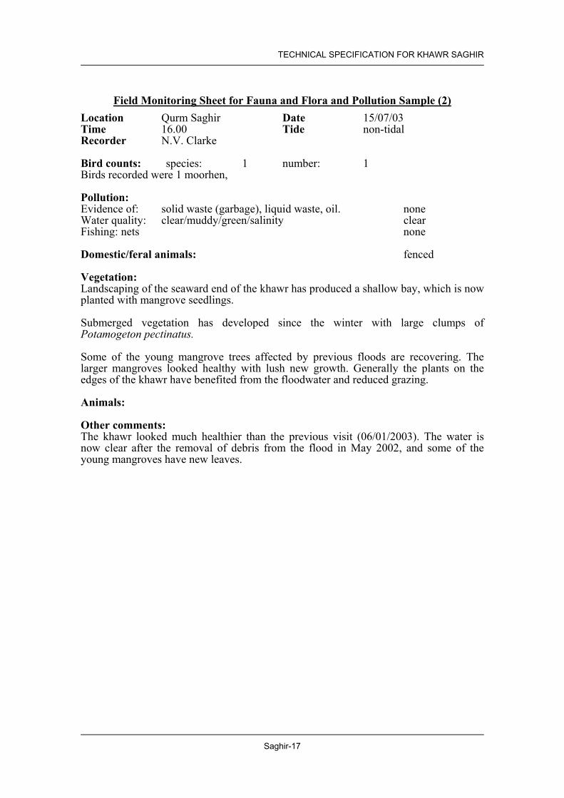
Field Monitoring Sheet for Fauna and Flora and Pollution Sample (2) Location Khawr Kabir Date 15/07/03 Time 12.00 Tide non-tidal Recorder N.V. Clarke Bird counts: species: 1 number: 10 Birds recorded were 10 night herons (roosting in mangroves) Pollution: Evidence of: solid waste (garbage), liquid waste, oil. none Water quality: clear/muddy/green/salinity clear Fishing: nets none Domestic/feral animals: recently fenced Vegetation: This is the site for a mangrove nursery and seedlings have been planted out on the seaward side of the khawr channel where the bank has been shaped to provide a shallow shelf. The main terrestrial plant zone along the edges of the khawr was the grass, Sporobolus virginicus, which was joined by the reed, Phragmites australis, along the drainage channels at the landward side of the mangroves. The vegetation of the drier sandy banks comprised the normal coastal plant association, (Suaeda vermiculata, Cyperus conglomeratus, Urochondra setulosa, Aeluropus lagopoides, Sporobolus spicatus, Cressa cretica, Heliotropium fartakense, Senra incana). Animals: A few burrowing shrimp holes (Callichirus sp) were seen. Small fish were abundant. Other comments: The mangroves of Khawr Kabir are recovering rapidly from overgrazing by camels since being fenced. Many young seedlings are appearing naturally among the larger trees. The mangroves form an important roosting area for night herons.

TECHNICAL SPECIFICATION FOR KHAWR KABIR
Kabir-17
“Attachment 8: Site Photos”
General Condition
View of midstream of water channel North shore near mouth of khawr
Mangrove Vegetation
Transplanted seedlings near beach side Standing dead trees at upstream of water channel
Soil Condition
Front of nursery under vegetation (Profile No. Ka-1)
Upstream of khawr under vegetation (Profile No. Ka-2)
Kabir-18
TECHNICAL SPECIFICATION FOR KHAWR KABIR
(Pro
file N
o.Ka-
1 )
Loca
tion
(K. K
abir)
fron
t of n
urse
ry un
der v
egeta
tion
Coor
dinate
(UTM
) Ea
sting
: 182
689
No
rthing
: 188
0357
Ph
ysiol
ogic
posit
ion
Lowe
r ter
race
To
pogr
aphy
Ge
ntle s
lope
Soil C
lassif
icatio
n Hu
maqu
eptic
(Moll
ic) F
luvaq
uents
Pa
rent
mater
ial
Alluv
ial de
posit
De
pth of
free
wa
ter
Surfa
ce w
ater
Vege
tation
/ ma
ngro
ve
Avice
nnia
marin
a veg
etatio
n Ob
serva
tion o
f cor
e sam
ple *1
De
scrip
tion o
f soil
profi
le *2
) O
0-8c
m Ol
ive b
lack (
5Y 3
.5/2)
loam
y san
d wi
th sin
gle g
rain
struc
ture
and
non-
stick
y con
sisten
cy; c
ommo
n gr
eyish
oliv
e (5
Y 4.5
/2)
mottle
; gra
dual
boun
dary
A 8-
23cm
Gr
eyish
oliv
e (5
Y 4/2
) soft
san
d wi
th sin
gle g
rain
struc
ture
and
non-
stick
y co
nsist
ency
; com
mon
grey
(5Y
4.5/1)
san
d mo
ttle; m
any s
mall r
oots;
grad
ual b
ound
ary
C 23
-32c
m Gr
ey (5
Y 5/1
) san
d wi
th sin
gle g
rain
struc
ture
and
non-
stick
y co
nsist
ency
; com
mon
grey
(5Y
4/1) m
ottle;
com
mon
small
ro
ots; w
avy b
ound
ary
C 32
-45c
m Ol
ive b
lack
(5Y
3/2)
silty
loam
with
stick
y co
nsist
ency
; co
mmon
small
and m
any v
ery s
mall t
oots
*1: D
escri
ption
s of s
tructu
re an
d bou
ndar
y are
estim
ated f
rom
limite
d obs
erva
tion o
f cor
e sam
ple.
*2: T
extur
e was
clas
sified
at fie
ld by
visu
al an
d tou
ching
obse
rvatio
n
(Pro
file N
o.Ka-
2 )
Loca
tion
(K. K
abir)
end o
f kha
wr un
der v
egeta
tion
Coor
dinate
(UTM
) Ea
sting
: 182
825
No
rthing
: 188
0503
Ph
ysiol
ogic
posit
ion
Mediu
m ter
race
To
pogr
aphy
Ge
ntle s
lope
Soil C
lassif
icatio
n Hu
maqu
eptic
(Moll
ic) F
luvaq
uents
Pa
rent
mater
ial
Alluv
ial de
posit
s De
pth of
free
wa
ter
22cm
Vege
tation
/ ma
ngro
ve
Avice
nnia
marin
a veg
etatio
n Ob
serva
tion o
f cor
e sam
ple *1
De
scrip
tion o
f soil
profi
le *2
) A
0-19
cm
Dull
yello
wish
bro
wn (1
0YR
4/3.5)
silty
loam
with
non
-stick
y co
nsist
ency
; man
y thi
n lay
ers;
many
blac
k an
d ye
llowi
sh g
rey
(7.5Y
2/1a
nd 2.
5Y 4/
1) m
ottles
C
19-2
7cm
Grey
ish o
live
(5Y
5/2)
sand
y loa
m cla
y wi
th sli
ghtly
stic
ky
cons
isten
cy; m
any
Grey
and
dull
red
dish
brow
n (5
Y 6/1
and
5YR
4/4) m
ottles
with
ston
es
C 27
-65c
m Si
lt, ma
ybe a
part
of 2n
d lay
er (d
ifficu
lt to t
ake c
ore s
ample
) C
65-9
2cm
Brow
nish
black
(5Y
R 3/1
~2/1
) ac
cumu
lation
of
orga
nic
matte
r *1
: Des
cripti
ons o
f stru
cture
and b
ound
ary a
re es
timate
d fro
m lim
ited o
bser
vatio
n of c
ore s
ample
. *2
: Tex
ture w
as cl
assif
ied at
field
by vi
sual
and t
ouch
ing ob
serva
tion
Att
achm
ent 9
: Soi
l Pro
files
in K
haw
r K
abir

Technical Specification for Khawr Saghir

TECHNICAL SPECIFICATION FOR KHAWR SAGHIR
Saghir-1
1. SITE DESCRIPTION
1.1 Location Governorate/ Region Dhofar Wilayat Salalah Distance from the Centre of Wylayat
This Khawr is located just west side of Hilton Salalah Hotel and is located approximately 10 km west of the city centre of Salalah.
Nearest Locality Salalah Fame of the Site/ Distinctive Features
None
Facilities in the Site The mangroves of Qurm Saghir were first fenced in 1996 to allow the trees to recover from overgrazing by camels. Floods damaged the fence, which was later repaired by 2002.
Features of Surrounding Areas The Hilton Hotel is considered as one of the best international hotels in Salalah.
1.2 Natural Conditions Climate Zone Dhofar Zone General Terrain Flat plain Geological Features No data History of Geological Change
In May 2002, a large cyclone produced floods and Qurm Saghir received considerable floodwater. However, the sandbar did not open to the sea and floating woody debris clogged the water, lowering the salinity and depleting the oxygen. This has now been cleared by bulldozer with some reshaping of the lower end to accommodate the planting of seedlings.
Soil Small-scale Khawr Saghir lies on the flat plain located west of Hilton Hotel in western part of Salalah. The khawr is cut off by short sandbar from sea. Mangroves cover the upper khawr. Some young vegetation occurred on both shores midstream of khawr but most of these plants were unhealthy (Jan 2003). Soil of this khawr is basically sand. Shallow (less than 10cm), silty and humic soil layers on sandy soils are found at the upper khawr where covered by vegetation. Shores are eroded and micro- topographically steep. Details are shown in attached table “Attachment 4: Soil Profile in Khawr Saghir” and “Attachment 9: Soil Profile Samples in Khawr Saghir
Water In January 2003, surface water in the khawr showed low pH, low DO and high COD. COD was very high (50to100mg/l). DO at mouth was less than 1mg/l and 1.75mg/l at upper khawr. There was a bad smell from the water. The surface of khawr was almost covered by floating substances including wood, leaves and rubbish, which were carried during flood in the spring season in 2002. Clean up operation to remove all floating materials was done on February 2003. The water quality has improved after clean up operation. DO changed from 0.9 to 5.9mg/l at khawr mouth and 1.75 to 3.4mg/l at khawr mouth but values of COD showed still high value (about 20mg/l) as shown in following table. Table Analysis of water quality in Khawr Saghir

TECHNICAL SPECIFICATION FOR KHAWR SAGHIR
Saghir-2
At Upper khawr At Khawr mouth Jan 2003 Jun 2003 Jan 03 Jun 2003
Salinity (%) 1.3 0.9 1.5 1.3 pH 7.1 7.9 7.2 8.1 DO (mg/l) 1.75 3.40 0.90 5.90 COD (mg/l)* 50± 10-20 100± 20±
Details are shown in attached table “Attachment 5: Surface Water Quality in Khawr Saghir”
Fauna A few large holes of the land crab (Cardisoma carnifex) were found on the landward edge of the mangroves. Burrowing shrimp holes (Callichirus sp) were not seen but a few holes of ghost crabs (Ocypode) were present. Numerous amphipods were found among the debris near the sandbar in January. Damsel and dragonflies represented a freshwater element. No fish were seen. Birds recorded were 1 moorhen, 1 common sandpiper, 3 sand plover and 1 grey wagtail.
Flora Some of the young mangrove trees were killed by the sudden change in salinity and oxygen levels and suffered from collapse of the sandy banks. The larger mangroves however looked very healthy with lush new growth and many of the smaller mangroves had recovered by July. Generally the plants on the edges of the khawr have benefited from the floodwater and reduced grazing. Submerged aquatic plants were absent in January 2003 but after clearing of the flood debris, clumps of Potamogeton pectinatus had appeared by July 2003. The grass and reeds (Sporobolus virginicus and Phragmites australis) showed excellent growth particularly along the drainage channels at the landward side of the mangroves. The vegetation of the drier sandy banks comprised the normal plant association for this zone (Suaeda vermiculata, Cyperus conglomeratus, Urochondra setulosa, Aeluropus lagopoides, Sporobolus spicatus, Cressa cretica, Heliotropium fartakense). There is some scope for planting mangrove seedlings at this khawr filling the gaps between existing trees. Ideally seeds from the same khawr should be used.
Impacts from the Surrounding Areas
The khawr is located next to Hilton Hotel.
1.3 Socio-economic Situation Population of the Wilayat (2001)
162 thousand
Population of the Nearest Locality (1993)
162 thousand
Main Economic Activities Residential area Infrastructure Just beside the national highway and close to Salalah city centre. Main Usage The site is designated as protected area and fenced to avoid graze by
camels. Community Interference with the Area
Road and utility lines are located closely.
Cultural Significance None

TECHNICAL SPECIFICATION FOR KHAWR SAGHIR
Saghir-3
1.4 Legal Setup and Development Plans Land Ownership and Land Use Designation
The Khawr was designated as a Nature Reserve by Royal Decree Royal Decree 49/97 dated 28/6/97 with the Ministry of Regional Municipalities and Environment as the managing authority. The management plan aims to protect the mangrove trees while allowing controlled access for fodder collection. Sustainable fishing and the use of the area as a picnic site would also be allowed.
Development Plans in the Site and the Surrounding Area
Housing Development
Existing Conservation Proposal
Declared as nature reserve in 1997
2. PROGRAMME AND PROJECT
2.1 Prerequisite Legal Setup for Land Use Control
Set a distinct boundary of NR and RDA (see 4.2 Required Action for Conservation and Management)
Facility Development Control No permanent structure in NR, except hide for bird watching, sign and information boards, and board walking or pedestrian bridge. Footpath should be designated but not paved. No permanent commercial buildings such as restaurants hotels shops and mechanized amusement facilities in the park development area. Basic activities in this park are relaxation and picnicking. Partial lighting for safety only. Utilities lines (water and electricity should be minimum) and setback 150 m from the edge of Mangrove.
2.2 Description of Programmes Facility Development Programme
N/A
Restoration and Afforestation Programme
N/A
Monitoring Programme (1) Mangrove monitoring project (2) Soil and water monitoring project (3) Fauna and flora monitoring project (4) Pollution monitoring project (5) Monitoring project on legal setup and development plans
Public Awareness Programme It will include an educational programme for school children and conservation campaign for residents of the Wilayat. Required materials and facilities are (6) Pamphlets and posters distributed to the residents, (7) Information boards describing significance of the natural environment.

TECHNICAL SPECIFICATION FOR KHAWR SAGHIR
Saghir-4
2.3 Implementation Mechanism Projects Responsible
Agencies Implementing
Body/ Agencies Related Agencies
(1) Mangrove Monitoring Project MRMEWR Wilayat Salalah/ MRMEWR
(2) Soil and Water Monitoring Project MRMEWR Wilayat Salalah/ MRMEWR
(3) Fauna and Flora Monitoring Project MRMEWR MRMEWR/ Omani Institute for Birds
(4) Pollution Monitoring Project MRMEWR Wylayat Salalah/ MRMEWR
(5) Monitoring Project on Legal Setup and Development Plans
MRMEWR Wilayat Salalah/ MRMEWR
(6) Pamphlets and posters distributed to the residents
MRMEWR MRMEWR MOE
(7) Information boards MRMEWR MRMEWR MOE
2.4 Implementation Schedule Project No. 1 st 2 nd 3 rd 4 th 5 th 6th 7th 8th 9 th 10 th
(1) (2) (3) (4) (5) (6) (7)
3. IMPLEMENTATION PLAN
3.1 Restoration and Afforestation
3.1.1 Existing Mangrove Area Location and Area Upper shore at Khawr Saghir covered by mangrove area is 1.7 ha
approximately. (Figure 2 Location Map) Conditions of Existing Mangrove
Small mangrove vegetation. Healthy and tall mangrove trees are lushly surviving on north bank at the upper khawr. Many long aerial roots are showing up from water. Tall trees reached more than 10m heights. Small and withered trees are scattering along narrow shore. Many seeds are producing after flowering season. New seedlings have planted by MRMEWR at the corner of western mouth (1500m2) in March 2003. Growing of these seedlings is not glowing well. No more grazing by camels due to fencing.

TECHNICAL SPECIFICATION FOR KHAWR SAGHIR
Saghir-5
3.1.2 Plantation Area Tidal Condition Normal: Mouth is closed Wave and Wind Calm in Winter, Drifted sand damages seaward fringe. Flood Every 5 to 10 years Water Salinity and PH Salinity; 1.3 ~ 1.5 %, PH; - 7.1 ~ 7.2 (“Attachment 5: Surface Water
Quality in Khawr Saghir”) Soil Conditions Sandy soil with aerobic condition. Surveyed data is in the “Attachment
4: Soil Profile in Khawr Saghir” of this technical specification. Potential Area N/A
Table 3.1 Location and Areas of Potential Planting Area(s)
Designated Area Area (ha) Area-1 No plantation
3.1.3 Conservation Area Area of Land Use Nature Reserve (NR) Area
3.1.4 Required Action for Conservation and Management Inspection N/A Cleaning N/A Replantation of Seedlings Growing Bad, Dead or Washed Away
N/A
Service for Associated Facilities
N/A
Patrol and Enforcement Daily ordinary patrol by a police office of Wilayat is required, and the management body regularly inspects facilities conditions and littering and waste disposal to the ground and water in NR areas.
Restoration and Rehabilitation Work
The mangrove plantation work in the planting area described in the previous section is necessary. The culvert will be necessary to improve the water environment in the existing mangrove area (“Figure 4: Proposed Culvert at Khawr Saghir”).
Facilities Required for the Conservation and Management Activities
Direction signs along the highway and entrance to the access road(s), guide signs in the reserve, and information boards in the NR area can be seen in the area to explain the significance of the reserve and major flora and fauna. Footpath and boardwalk for observation of wild life as well as mangrove are also necessary.

TECHNICAL SPECIFICATION FOR KHAWR SAGHIR
Saghir-6
3.2 Monitoring
3.2.1 Mangrove Monitoring Method Existing mangrove:
Label trees for monitoring. Monitor mangrove by using the attached “Attachment 1: Field Monitoring Sheet for Mangrove”.
Mangrove planted: First 4 years: tree height, canopy X:Y After 4 years: follow monitoring sheet
Frequency Existing mangrove: Every 2 years Mangrove planted: First 4 year: annual monitoring After 4 year: every 2 year
Monitoring Target Existing mangrove: 1) Sg-OT1: Coordinate Easting 181841 /Northing 1879841 2) Sg-OT3: Coordinate Easting 181908 /Northing 1879833 Mangrove planted: Select 20 trees at random and monitor them.
Baseline Data Baseline data and monitoring trees are listed in “Attachment 2: List of the Observed Points in Khawr Saghir”.
3.2.2 Soil and Water Monitoring Method Monitoring soil and water in and around mangrove vegetation by using
attached table “Attachment 3: Field Monitoring Sheet for Soil and Water (Khawr Saghir)”
Frequency Soil: (Mangrove planted area) Every 2 year (Existing mangrove area) Every 2 Year Water; Before (Apr) and after (Nov) monsoon season (Every year) (Outflow water at low tide should be measured.)
Monitoring Target Attachment 3 Baseline Data See attached table “Attachment 4: Soil Profile in Khawr Saghir” and
“Attachment 5: Surface Water Quality in Khawr Saghir”
3.2.3 Fauna and Flora Monitoring Method Monitor fauna and flora by using the attached “Attachment 6: Field
Monitoring Sheet for Fauna and Flora and Pollution” For the observation of birds, an institute that is studying birds in Oman can be the best institute to take a part of the monitoring work by sub-contract base.
Frequency At least twice a year Monitoring Target Attachment 6 Baseline Data The result of field reconnaissance of flora and fauna is shown in
“Attachment 7: Result of Field Reconnaissance of Flora and Fauna and Pollution in Khawr Saghir”

TECHNICAL SPECIFICATION FOR KHAWR SAGHIR
Saghir-7
3.2.4 Pollution (garbage and waste) Monitoring Method Monitor pollution by using the attached “Attachment 6: Field
Monitoring Sheet for Fauna and Flora and Pollution.” Water Quality and Soil Sample Tests should be carried out by MRMEWR.
Frequency At least twice a year Monitoring Target Attachment 6 Baseline Data See “Attachment 7: Result of Field Reconnaissance of Flora and
Fauna and Pollution in Khawr Saghir”
3.2.5 Change on Legal Setup and Development Plans Frequency At least once a year Monitoring Target Any changes on legal situation of the site should be recorded. Land
Ownership, Land Use Designation, Development Plans in the Site and Surrounding Area

TECHNICAL SPECIFICATION FOR KHAWR SAGHIR
Saghir-8
Figure 1 Key Map

Saghir-9
TECHNICAL SPECIFICATION FOR KHAWR SAGHIR
Figu
re 2
L
ocat
ion
Map

Saghir-10
TECHNICAL SPECIFICATION FOR KHAWR SAGHIR
Figu
re 3
Pl
antin
g M
ap

TECHNICAL SPECIFICATION FOR KHAWR SAGHIR
Saghir-11
“Attachment 1: Field Monitoring Sheet for Mangrove”
Mangrove Observation Recors
1) Identification No.
2) Location by GPS (WGS 84, UTM)Easting:
Northing:
3) Photograph No.
4) Observation of tree size and shape a) Tree Height (cm)b) Trunk diameter near botto m (cm)C) Live branches at the position about 1.3m off the center of tree bottom (painted)
Branch/ limb diameter measured in cm1 2 3 4
5 6 7 8
9 10
5) Obsrevation of tree history, helth and environmenta) History
Tree shape: Sign of cut in the past:
b) Health Nodes with leaves:
Inter-node length:Leaf length:Leaf color:
Looks / die back:
C) EnvironmentSoil depth / texture:
Surface water Salinity:Ground level:
Position:
Note:
Memo:(specific information or data significant for the tree willbe written here)
Records
b) Trunk diameter near bottom (cm) c) Live branches at the position about 1.3m off the centre of tree bottom (painted)
5) Observation of tree history, health and environment
c) Environment
Leaf colour:

Saghir-12
TECHNICAL SPECIFICATION FOR KHAWR SAGHIR
“Att
achm
ent 2
: Lis
t of t
he O
bser
ved
Poin
ts in
Kha
wr
Sath
er”
12
34
56
78
910
Sagh
irSg
-OT1
122
Dec
'02
1818
4118
7984
1sa
ghirt
ree1
b87
818
6.5
9.3
9.7
1711
5.2
Sagh
irSg
-OT2
22 D
ec '0
218
1829
1879
860
902
50Sa
ghir
Sg-O
T32
22 D
ec '0
218
1908
1879
833
sagh
irtre
e2a
& 2
b10
2312
2817
7.3
1214
1236
Kha
wr
Tre
eN
umbe
rM
onito
ring
Tre
es
Dat
e of
Obs
erva
tion
Rem
arks
East
ing
Nor
thin
gTr
unk
near
botto
m
Live
bra
nche
s at t
he p
ositi
on a
bout
1.3
m o
ff th
ece
nter
of t
ree
botto
m (D
BH
: Dia
met
er B
reat
h H
eigh
t)
Coo
rdin
ate
(UT
M)
Phot
o N
umbe
rH
eigh
t(c
m)
Dia
met
er (c
m)
Live
bra
nche
s at t
he p
ositi
on a
bout
1.3
m o
ff th
e ce
ntre
of t
ree
botto
m
(DB
H: D
iam
eter
Bre
ast H
eigh
t)
D
ate o
f O
bser
vatio
n

TECHNICAL SPECIFICATION FOR KHAWR SAGHIR
Saghir-13
“Attachment 3: Field Monitoring Sheet for Soil & Water (Khawr Saghir)”
Location Date / time: / ,200 : Recorder General Condition in plantation area:
(garbage, rubbish, leaf, alga, crab, shell, etc) (1) Soil Condition
Transplanted Mangrove① Existing Mangrove ② Easting 182000 181900 Coordinate Northing 1879750 1879840
Surface condition 0-10cm
30-40cm Soil Texture
50-60cm 0-10cm
30-40cm Soil Colour
50-60cm Root development Depth of surface humus
GWL* (cm) pH Free
water Salinity (%)
Soil colour by Munsell notation, GPS*:by UTM of WGS84 GWL: Ground water level
(2) Surface Water Quality (Observation time: : ) Khawr mouth ③ Upper khawr ④ Easting 182040 181850
Coordinate Northing 1879750 1879840
Surface waste pH Salinity (%) Temperature (C) DO (mg/l) Turbidity / Colour
●Soil ○ Water
3
4
1
Location of monitoring
2

Saghir-14
TECHNICAL SPECIFICATION FOR KHAWR SAGHIR
“Att
achm
ent 4
: Soi
l Pro
file
in K
haw
r Sa
ghir
”
“Att
achm
ent 5
: Sur
face
Wat
er Q
ualit
y in
Kha
wr
Sagh
ir”
Easti
ngN
orth
ing
Dep
th(c
m)
pHSa
linity
(%)
Surfa
ce(0
-30c
m)
Sub-
surfa
ce(3
0-60
cm)
Dee
p la
yer
(>90
cm)
Surfa
ce (
0-30
cm)
Sub-
surfa
ce (3
0-60
cm)
Surfa
ceSu
b-su
rface
Sa-1
Nor
th sh
are,
up-
strea
m u
nder
vege
tatio
n18
1902
1879
868
Core
sam
ple,
unde
r sur
face
wat
erCl
ay lo
am -
silt
Silty
- Sa
ndSa
ndBl
ack
- dar
kgr
ayish
yel
low
Dar
k gr
ayish
yello
wSo
ftSo
ft
Sa-2
Sout
h sh
are,
1.5
m fr
om w
ater
chan
nel
1819
5718
7981
9N
o w
ater
Sand
y -
sand
Sand
Sand
Yel
low
ishbr
own
Gra
yish
- du
llye
llow
Har
d-
Dat
a of
har
dnes
s in
pare
nthr
sis b
y ha
nd o
bser
vatio
n
Soil
Colo
rH
ardn
ess
Prof
ileN
o.
Coor
dina
te (U
TM)
Gro
und
Wat
erTe
xtur
eLo
catio
nSo
il C
olou
r
Bla
ck -
dark
gr
eyis
h ye
llow
Dar
k gr
eyis
h ye
llow
Gre
yish
-du
ll ye
llow
East
ing
Nor
thin
g1
Mou
th o
f kha
wr
1820
3618
7973
4++
7.2
1.5
20.1
0.90
100±
-
2In
mos
t up
stre
am o
f kha
wr
1818
7718
7983
9++
7.1
1.3
-1.
7550
±-
3M
outh
of k
haw
r18
2036
1879
731
±8.
11.
331
.25.
9020
±1>
4M
id k
haw
nor
th sh
ore
1819
4418
7985
8+
8.0
1.1
31.2
2.30
20±
25
Inm
ost
upst
ream
of k
haw
r18
1822
1879
834
++7.
90.
931
.93.
4010
-20
-O
bser
vatio
n D
ate:
12-
14 Ja
nuar
y 20
03 fo
r sam
ple
No.
1-2,
31
May
200
3 fo
r sam
ple
No.
3-5
No.
Coo
rdin
ate
(UTM
)Lo
catio
nD
O(m
g/l)
CO
D(m
g/l)
NO
3(m
gNO
3/l)
Col
or/
Vis
ibili
typH
Salin
ity(%
)Te
mpe
ra-
ture
(C)
Col
our/
Vis
ibili
ty
Dat
a of
har
dnes
s in
pare
nthe
sis b
y ha
nd o
bser
vatio
n

TECHNICAL SPECIFICATION FOR KHAWR SAGHIR
Saghir-15
“Attachment 6: Field Monitoring Sheet for Flora and Fauna and Pollution”
Location Qurm Saghir Date Time Tide Recorder Bird counts: species: number: Winter birds expected: moorhen, waders, plovers, herons Summer birds expected: night heron Pollution: Evidence of: solid waste (garbage), liquid waste, oil. Water quality: clear/muddy/green/salinity Fishing: nets Domestic/feral animals: Vegetation: Submerged: Water edge: Sandy bank: Animals: Other comments:

TECHNICAL SPECIFICATION FOR KHAWR SAGHIR
Saghir-16
“Attachment 7: Result of Field Reconnaissance of Fauna and Flora and Pollution in Khawr Saghir”
Field Monitoring Sheet for Fauna and Flora and Pollution Sample (1) Location Qurm Saghir Date 06/01/2003 Time 08.00 Tide non-tidal Recorder N.V. Clarke Bird counts: species: 3 number: 5 Birds recorded were 1 moorhen, 1 common sandpiper, 3 sand plover and 1 grey wagtail. Pollution: Evidence of: solid waste (garbage), liquid waste, oil. Full of flood debris Water quality: clear/muddy/green/salinity stagnant Fishing: nets none Domestic/feral animals: fenced Vegetation: Some of the young mangrove trees were killed by the sudden change in salinity and oxygen levels and suffered from collapse of the sandy banks. Submerged aquatic plants were also absent. The larger mangroves however looked very healthy with lush new growth. Generally the plants on the edges of the khawr have benefited from the floodwater and reduced grazing. The grass and reeds (Sporobolus virginicus and Phragmites australis) showed excellent growth particularly along the drainage channels at the landward side of the mangroves. The vegetation of the drier sandy banks comprised the normal plant association for this zone (Suaeda, Cyperus conglomeratus, Urochondra setulosa, Aeluropus lagopoides, Sporobolus spicatus, Cressa cretica, Heliotropium fartakense). A small shrubby mallow (Senra incana) was also present. A composite (Eclipta alba) was found on wet sand near the sandbar. Animals: A few large holes of the land crab (Cardisoma carnifex) were found on the landward edge of the mangroves. Burrowing shrimp holes (Callichirus sp) were not seen but a few holes of ghost crabs (Ocypode) were present. Numerous amphipods were found among the debris near the sandbar. Damsel and dragonflies represented a freshwater element. No fish were seen. Other comments: The mangroves of Qurm Saghir were fenced in 2002 to allow the trees to recover from overgrazing by camels. In May 2002, a large cyclone produced floods around Salalah and Qurm Saghir received considerable floodwater. However, the sandbar did not open to the sea and floating woody debris is clogging the water. Where the debris covers the surface oxygen levels are depleted. The flood also lowered the salinity of the water, which is now 0.9% at the drainage entrance and 1.5% nearer the mouth (previously it varied from about 2.0 –3.5 %). Compared with 1993, the khawr had less marine species (Callichirus not seen). It is also unlikely that the white shrimp (Penaeus indicus) previously recorded survived the flood conditions.
TECHNICAL SPECIFICATION FOR KHAWR SAGHIR
Saghir-17
Field Monitoring Sheet for Fauna and Flora and Pollution Sample (2) Location Qurm Saghir Date 15/07/03 Time 16.00 Tide non-tidal Recorder N.V. Clarke Bird counts: species: 1 number: 1 Birds recorded were 1 moorhen, Pollution: Evidence of: solid waste (garbage), liquid waste, oil. none Water quality: clear/muddy/green/salinity clear Fishing: nets none Domestic/feral animals: fenced Vegetation: Landscaping of the seaward end of the khawr has produced a shallow bay, which is now planted with mangrove seedlings. Submerged vegetation has developed since the winter with large clumps of Potamogeton pectinatus. Some of the young mangrove trees affected by previous floods are recovering. The larger mangroves looked healthy with lush new growth. Generally the plants on the edges of the khawr have benefited from the floodwater and reduced grazing. Animals: Other comments: The khawr looked much healthier than the previous visit (06/01/2003). The water is now clear after the removal of debris from the flood in May 2002, and some of the young mangroves have new leaves.

TECHNICAL SPECIFICATION FOR KHAWR SAGHIR
Saghir-18
“Attachment 8: Site Photos”
General Condition
East shore West shore with natural regeneration
Mangrove Vegetation
Mangroves at upstream of water channel Transplanted trees on reclamation area
Soil Condition
North share, up-stream under vegetation (Profile No. Sa-1)
South share, 1.5m away from water channel (Profile No. Sa-2)

Saghir-19
TECHNICAL SPECIFICATION FOR KHAWR SAGHIR
(Pro
file N
o.Sa-
1 )
Loca
tion
(K. S
aghir
) nor
th sh
ore,
up-st
ream
unde
r veg
etatio
n Co
ordin
ate (U
TM)
Easti
ng: 1
8190
2
North
ing: 1
8798
68
Phys
iolog
ic po
sition
Lo
wer t
erra
ce
Topo
grap
hy
Slop
e So
il Clas
sifica
tion
Huma
quep
tic (M
ollic)
Fluv
aque
nts
Pare
nt ma
terial
Al
luvial
depo
sits
Depth
of fr
ee
water
No
t dete
rmine
d
Vege
tation
/ ma
ngro
ve
Near
Avic
ennia
mar
ina ve
getat
ion
Obse
rvatio
n of c
ore s
ample
*1
Desc
riptio
n of s
oil pr
ofile
*2)
A 0-
5cm
Blac
k (2
.5Y 2
/1) c
lay lo
am w
ith s
ticky
con
sisten
cy; m
any
very
small
roots
; gra
dual
boun
dary
C 5-
23cm
Da
rk gr
eyish
yell
ow (
2.5Y
4/2)
silty
clay
loam
with
stick
y co
nsist
ency
; few
very
small
roots
; gra
dual
boun
dary
C 23
-31c
m Gr
eyish
yello
w (2
.5Y 6
/2) si
lt with
stick
y con
sisten
cy; g
radu
al bo
unda
ry C
31-4
1cm
Dark
grey
ish y
ellow
(2.5
Y 5/2
) sil
t wi
th sli
ghtly
stic
ky
cons
isten
cy; w
ith gr
avels
; clea
r bou
ndar
y C
41-4
8cm
Brow
nish
black
(2.5Y
3/2)
san
d wi
th ma
ssive
stru
cture
and
no
n-sti
cky
cons
isten
cy;
with
grav
els;
many
dar
k re
ddish
br
own (
5YR
3/2) m
ottles
;
*1: D
escri
ption
s of s
tructu
re an
d bou
ndar
y are
estim
ated f
rom
limite
d obs
erva
tion o
f cor
e sam
ple.
*2: T
extur
e was
clas
sified
at fie
ld by
visu
al an
d tou
ching
obse
rvatio
n
(Pro
file N
o.Sa-
2 )
Loca
tion
(K. S
ather
) sou
th sh
ore,
1.5m
away
from
wate
r cha
nnel
Coor
dinate
(UTM
) Ea
sting
: 181
957
No
rthing
: 187
9819
Ph
ysiol
ogic
posit
ion
Uppe
r ter
race
To
pogr
aphy
Un
dulat
ing
Soil C
lassif
icatio
n Ty
pic T
orrifl
uven
ts Pa
rent
mater
ial
Alluv
ial de
posit
s De
pth of
free
wa
ter
No w
ater in
profi
le
Vege
tation
/ ma
ngro
ve
No ve
getat
ion, 1
m aw
ay fr
om kh
awr s
hore
Desc
riptio
n of s
oil pr
ofile
*2)
A 0-
6cm
Olive
bro
wn (
2.5Y
4/3.5)
com
pact
loamy
san
d wi
th pla
te str
uctur
e and
non-
stick
y con
sisten
cy; c
ommo
n dull
yello
w (2
.5Y
6/3) m
ottle;
grad
ual s
mooth
boun
dary
C 6-
19cm
Ye
llowi
sh b
rown
(2.5
Y 5/4
) co
mpac
t sa
nd w
ith m
assiv
e str
uctur
e and
non-
stick
y con
sisten
cy; d
iffuse
smoo
th bo
unda
ry C
19-4
9cm
Grey
ish y
ellow
(2.5
Y 6/2
) sa
nd w
ith s
ingle
mass
ive a
nd
non-
stick
y con
sisten
cy; f
ew ye
llowi
sh b
rown
(10Y
R 5/6
) mott
le;
grad
ual w
avy b
ound
ary
C 49
-55c
m Du
ll ye
llow
(2.5Y
6/3)
san
d wi
th ma
ssive
stru
cture
and
no
n-sli
ghtly
stick
y con
sisten
cy, g
rave
ls un
der t
his la
yer
*1: D
escri
ption
s of s
tructu
re an
d bou
ndar
y are
estim
ated f
rom
limite
d obs
erva
tion o
f cor
e sam
ple.
*2: T
extur
e was
clas
sified
at fie
ld by
visu
al an
d tou
ching
obse
rvatio
n
Att
achm
ent 9
: Soi
l Pro
files
in K
haw
r Sa
ghir

Chapter 2: Technical Guideline for Afforestation
THE MASTER PLAN STUDY ON RESTORATION, CONSERVATION AND MANAGEMENT OF MANGROVE IN THE SULTANATE OF OMAN
2-1
2. Technical Guideline for Afforestation
2.1 General
2.1.1 Objective of Guideline Preparation
This Guideline is prepared for mangrove plantation work to be carried out by those who intend to implement the mangrove plantation on site. Therefore, descriptions in the guideline should be as practical as possible. A guideline user who is interested in more scientific background should consult with MRMEWR personnel in charge.
Descriptions in this guideline are all for Avicennia marina that is the only native mangrove and commonly found in Oman.
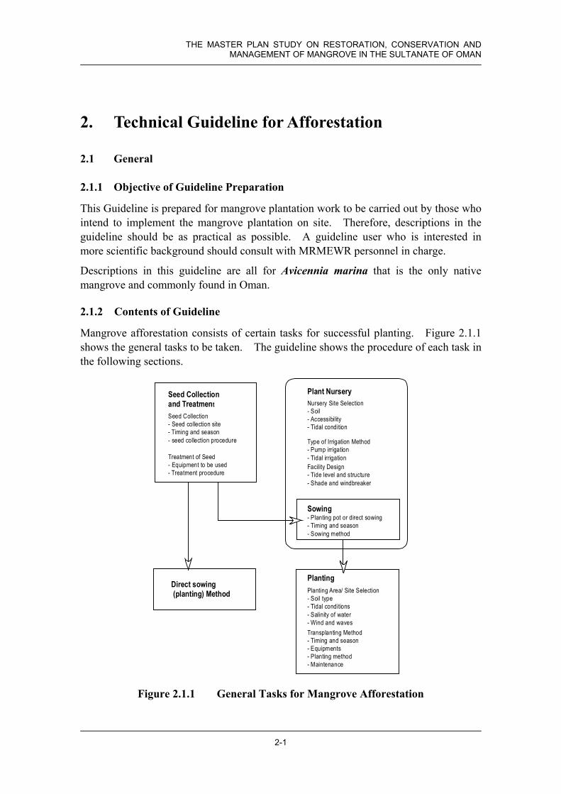
2.1.2 Contents of Guideline
Mangrove afforestation consists of certain tasks for successful planting. Figure 2.1.1 shows the general tasks to be taken. The guideline shows the procedure of each task in the following sections.
Seed Collection- Seed collection site- Timing and season- seed collection procedure
Treatment of Seed- Equipment to be used- Treatment procedure
Sowing- Planting pot or direct sowing- Timing and season- Sowing method
Plant NurserySeed Collectionand Treatment Nursery Site Selection
- Soil- Accessibility- Tidal condition
Type of Irrigation Method- Pump irrigation- Tidal irrigationFacility Design- Tide level and structure- Shade and windbreaker
PlantingPlanting Area/ Site Selection- Soil type- Tidal conditions- Salinity of water- Wind and wavesTransplanting Method- Timing and season- Equipments- Planting method- Maintenance
Direct sowing(planting) Method
Figure 2.1.1 General Tasks for Mangrove Afforestation
Chapter 2 Technical Guideline for Afforestation
2-2
2.2 Guideline for Seed Collection
2.2.1 General Characteristics of Mangrove (Avicennia marina) Seed
Mangrove seeds cannot be stored for a long period because they are viviparous, in other words they are germinated already. Therefore, the seeds are quite delicate and deteriorate easily in hot and dry condition. Special care and attention is required for seed collection, storage and treatment.
Mangrove (Avicennia marina) seeds have pericarp for floatation in seawater, and seed coat (pericarp) also protects from dry conditions. When the seed matures, it drops in to the seawater, and seed coat is removed after 6 hours to 2days. These characteristics of mangrove seed should be taken in to consideration for treatment and storage.
The following shows the general flow of seed collection and treatment.
Planning andpreparation(1) determination ofseed collection timingand season(2) determination ofseed collection site
and areas(3) preparation ofnursery for sowingor plant ing area atdesignated sits
Seed Collectionat site/ area
Treatment ofcollected seeds
Sowing topot at nurseryor direct plantingto the plantation site
Stored andtransported tonursery ifnesessary
Tasks for seed collecting and treatment
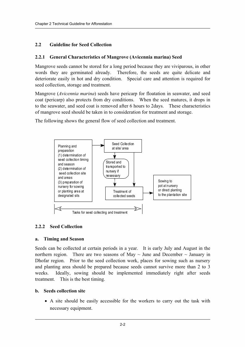
2.2.2 Seed Collection
a. Timing and Season
Seeds can be collected at certain periods in a year. It is early July and August in the northern region. There are two seasons of May ~ June and December ~ January in Dhofar region. Prior to the seed collection work, places for sowing such as nursery and planting area should be prepared because seeds cannot survive more than 2 to 3 weeks. Ideally, sowing should be implemented immediately right after seeds treatment. This is the best timing.
b. Seeds collection site
• A site should be easily accessible for the workers to carry out the task with necessary equipment.

THE MASTER PLAN STUDY ON RESTORATION, CONSERVATION AND MANAGEMENT OF MANGROVE IN THE SULTANATE OF OMAN
2-3
• Basically, near the nursery site. In case of direct planting, the site should be located as close as possible.
• Workers for implementation should be available in the vicinity of the site.
• Seawater for treatment of the collected seeds should be abundant near the nursery or planting site where seed treatment is carried out.
• Healthy and matured mangrove forest should be selected for the seed collection site.
c. Procedure
• Size of seed to be collected should be large, preferably weighing more than 3 grams with pericarp, and the seeds should be mature.
• The collected seeds should be treated within 1~2 hours.
• In case the seeds are stored after collection, they should not be wet during the collection work.
2.2.3 Treatment of Seed
a. Equipment
• Large water containers (or buckets) with a capacity of 70~100 liters each. The number of containers will be determined by the number of workers and sowing schedule. If sowing is implemented immediately after treatment of the seeds, the required number of containers is 2 or 3.
• Meshed nets (the same number as the large buckets or containers).
• Small buckets or water pump to draw water (if the same number of small buckets as containers mentioned above can be prepared, small buckets are preferable to water pump.)
b. Procedure
The collected seeds need pretreatment before sowing.
• At first, the collected seeds should be soaked and washed for 6 hours or more by seawater. Put the collected seeds into the large container and fill with fresh clean seawater. The amount of seeds put in to the container should be less than one sixth (1/6) of volume of the container to avoid damage to the seeds by their weight.

Chapter 2 Technical Guideline for Afforestation
2-4
• After a little while, the wastewater in the container (bucket) will change color to brown. Change the water every 2 hours or more frequently.
• When changing the soaking water, cover the container by mesh net, and empty the wastewater out of the container. This water will damage the seeds and the nursery. Therefore, the wastewater used for soaking and washing the seeds should not be dumped inside the nursery but outside.
• Seed coats (pericarp) of the seeds will be peeled off by themselves, otherwise,
they should be removed manually. Removed seed coats will also damage the seeds, so after the seed coats are removed, the seeds should be put into another plastic container (bucket) filled with new seawater for washing for 6 hours or more and the removed seed coats should be taken out of the bucket.

THE MASTER PLAN STUDY ON RESTORATION, CONSERVATION AND MANAGEMENT OF MANGROVE IN THE SULTANATE OF OMAN
2-5
2.2.4 Storage of Seeds
Storage of seeds will be required when sowing cannot be implemented immediately after the seed coat is removed. For example, the nursery is located at remote area or needs long distance transportation. In some cases, sowing cannot catch up with progress of seed collection and treatment work.
• Store seeds with seed coat in a cool and dry shaded area. Temperature should be less than 26 degree, and seeds should not be wet. Water and temperature lead to germination. Seeds can be stored for 10 to 15 days.
• Keep cool and away from water is the key.
2.3 Sowing
After the pre-treatment, seeds can be sown. The following pictures show an example of sowing into a seedling pot (agricultural vinyl pot) to be used in the nursery.
• Seedling pot to be used is the agricultural vinyl pot. The size is 10cm diameter and 25cm height with punched holes for water to drain.
Depth for sowing
2~3 seeds/pot

Chapter 2 Technical Guideline for Afforestation
2-6
• Normal beach sand at the site or near the nursery should be used. No silt or muddy soil should be used.
• 2 to 3 seeds per pot.
• One third (1/3) to half (1/2) of the seed should be out of sand.
• Seedling pots should be under shade for 2 to 3 weeks after sowing seeds.
2.4 Guideline for Plant Nursery Operation
There are two types of nurseries. One is a permanent type, which continuously supplies seedlings to various planting sites. A permanent type of plant nursery can cover time distance of two hours drive as a designated supply area. It is usually 100 to 150 km of distance to the planting sites from a nursery. The supply capacity of a nursery is also a factor to be planned in a nursery site. If one nursery cannot meet the demand of seedlings in the designated supply area, additional nurseries or a temporary nursery described below should be considered.
The other type of plant nursery is a temporary type. When a designated mangrove plantation site is in the remote area, and the supply of equipment, materials and access for maintenance staff is difficult, provision of a temporary nursery should be considered.
In this section the permanent type of a nursery is discussed first. The temporary type nursery will be discussed in the separate sub-section.
Figure 2.4.1 shows a general flow of plant nursery development and operation.

THE MASTER PLAN STUDY ON RESTORATION, CONSERVATION AND MANAGEMENT OF MANGROVE IN THE SULTANATE OF OMAN
2-7
Site Selection
Determination ofIrrigation Method
Facility Design
Sowing
Operation andMaintenance
- Mangrove Conservation and Plantation plan in future- Seedling Demand and Supply Plan in designated planting site- Natural and social conditions of Seed Collection Site
and Nursery Site
- Tidal Condition and available seawater- Soil type
- Size and number of the plant irrigation ponds- Site plan and layout of the facility- Structure plan and construction materials
- Preparation of planting pots- Sowing seed
- Irrigation method and frequency of watering- Shade and wind protection- Other maintenance
Figure 2.4.1 General Flows of Plant Nursery Development and Operation
2.4.1 Site Selection
Nursery sites should fulfil the following conditions.
• A strategic location should be selected to meet the future mangrove conservation and management plan (distance to the planting area, accessibility for operation and management).
• The scale of nursery should be determined by the future seedling demand.
• The site should be in the vicinity of a lagoon or of an arm of the sea (irrigation water supply condition).
• Soil at the site should be suitable for the plant pots, which will be used in a nursery.
• Accessibility for operation and maintenance should be convenient.
• The site should be free from floodwater.

Chapter 2 Technical Guideline for Afforestation
2-8
2.4.2 Irrigation Method and Site Preparation
There are two types of irrigation method. One is a pump irrigation method, and another is a tidal irrigation method. The following table shows the selection criteria of an irrigation method.
At first, examine the tidal condition of the site, and then check the water infiltration of soil. It is impossible to apply a tidal irrigation method without distinct tidal effect.
Item Condition Pump Irrigation Tidal Irrigation
Distinct tidal level changes every day and all year
Applicable
(1) Tidal condition
Indistinct tidal level changes due to the sand bar accumulation at the mouth of lagoon
Applicable
High infiltration of water (coarse to medium sand) Applicable (2) Soil Low infiltration of water (fine sand or silt) Applicable
The site should be graded flat with special care with its elevation in conjunction with a tide level as described in the next section. Necessary access roads and utilities will be prepared.
2.4.3 Facility Design
a. Tide and elevation of structure
Most essential element of design is a tide level. Elevation of plant pool floor, intake (tidal irrigation) and overflow drain channel (pump irrigation) shall be determined by the tide level. The following shows how to determine the intake level for a tidal irrigation nursery.
• From the tide table, choose the highest tide every day------ H
• Select the lowest among the H -----------------------(Lowest H)
• Chose the lowest tide every day ------------------------------- L
• Select the highest among the L---------------------- (Highest L)
• Set Intake Level = (Lowest H + Highest L) /2
For the pump irrigation, discharge of overflow irrigation water and drainage is necessary, therefore the elevation of the planting pool floor is usually set higher than the highest High Tide.
Select highest among H from the tide table (Highest H), and then set the outlet level at least 50 cm higher than Highest H.
THE MASTER PLAN STUDY ON RESTORATION, CONSERVATION AND MANAGEMENT OF MANGROVE IN THE SULTANATE OF OMAN
2-9
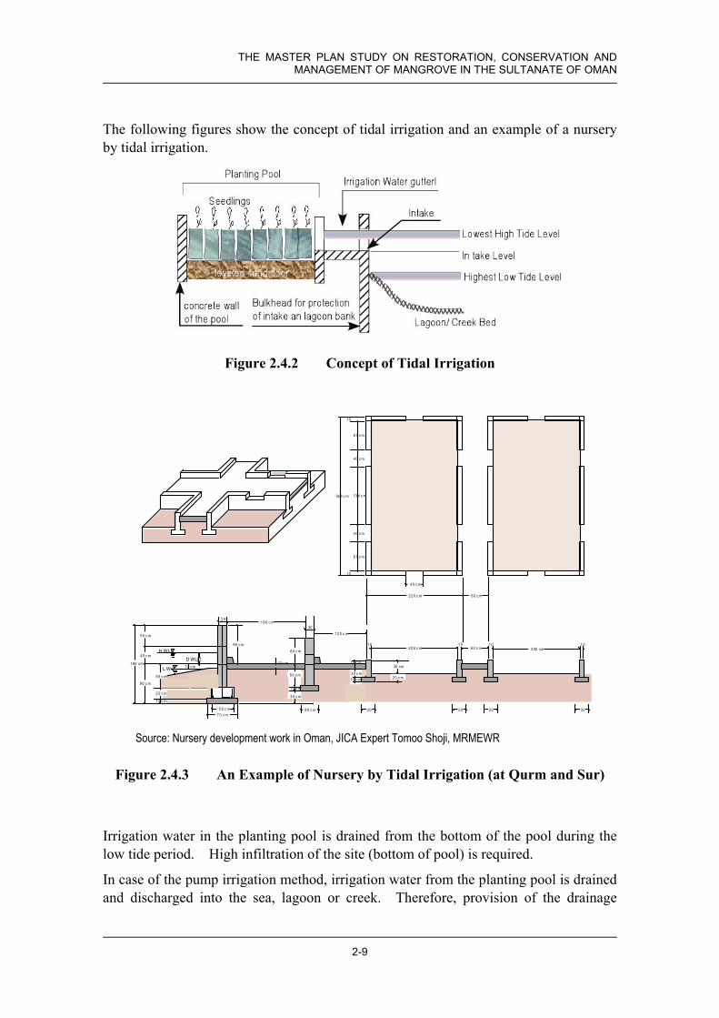
The following figures show the concept of tidal irrigation and an example of a nursery by tidal irrigation.
Figure 2.4.2 Concept of Tidal Irrigation
L W L
D WL
H W L
1 80 cm
2 5 c m
1 0 c m
9 0 c m
5 0 c m
5 5 c m
4 0 c m
10 cm
9 0 c m6 0 c m
1 8 0 c m
1 2 0 c m
5 0 c m
1 0 c m
2 0 0 c m 6 0 c m
30 cm1 0 c m
1 0 c m
1 0 c m
2 00 cm1 0 1 0
2 0
20
1 0 1 0
3 0 c m
7 0 c m5 0 c m 4 0 c m 3 0 3 0 3 0 3 0
3 0 c m2 0 c m
2 2 0 c m 6 0 c m
6 7 c m
1 3 4 c m
6 7 c m
36 8 c m
4 0 c m
4 0 c m
4 0 c m
10
10
Source: Nursery development work in Oman, JICA Expert Tomoo Shoji, MRMEWR
Figure 2.4.3 An Example of Nursery by Tidal Irrigation (at Qurm and Sur)
Irrigation water in the planting pool is drained from the bottom of the pool during the low tide period. High infiltration of the site (bottom of pool) is required.
In case of the pump irrigation method, irrigation water from the planting pool is drained and discharged into the sea, lagoon or creek. Therefore, provision of the drainage

Chapter 2 Technical Guideline for Afforestation
2-10
gutter and drain outlet is required, and they should be higher than the Highest High Tide level.
Source: Nursery development work in Oman, JICA Expert Tomoo Shoji, MRMEWR
Figure 2.4.4 Drain Outlet for the Pump Irrigation Nursery
b. Shade and windbreaker
Direct sunlight and hot dry wind damage sowed seeds and young seedlings. Provision of shade and windbreaker is required.
The following pictures show an example of shade and windbreaker covering the nursery.
Frame constructed
by steel pipes.
An intake channel

THE MASTER PLAN STUDY ON RESTORATION, CONSERVATION AND MANAGEMENT OF MANGROVE IN THE SULTANATE OF OMAN
2-11
2.4.4 Temporary Nursery Construction
In case the designated planting area is far from the nursery, which supplies seedlings for planting, a temporary nursery construction can be considered. Criteria for site selection is the same as tidal irrigation type nursery described in previous section.
Facility design procedure and conditions to be fulfilled is also the same as the tidal irrigation type nursery. However the structure of the temporary nursery is much simpler than permanent type. The construction materials to be used are mainly available at site and minimal requirement of concrete structures.
Number of planting pool to be constructed should be determined by calculating the number of seedling to be required for the designated planting area and planting schedule. One planting pool can contain 500 pots.
Following figure shows the conceptual design of the temporary nursery layout and structure.
Schematic Design of Temporally Nursery Construction

Chapter 2 Technical Guideline for Afforestation
2-12
2.4.5 Operation and Maintenance (shading and irrigation)
Main activities after sowing seeds are irrigation management and shade control.
• Pots in the planting pool should be irrigated by seawater. Fill the pool once in a day and drain naturally.
• The pool should be covered by shade for 2 to 3 weeks after sowing.
• Open shade and give sun light to the seedling for better growth.
• Germination will be observed around 1 week ~ 10 days after the sowing as seen in this photograph.
• This is a general view of the nursery almost 4 months after the sowing.
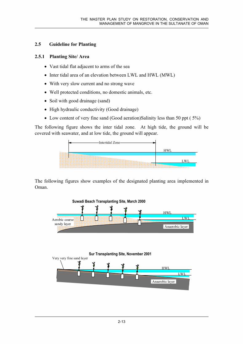
THE MASTER PLAN STUDY ON RESTORATION, CONSERVATION AND MANAGEMENT OF MANGROVE IN THE SULTANATE OF OMAN
2-13
Anaerobic layer
HWLLWLAerobic coarse
sandy layer
Suwadi Beach Transplanting Site, March 2000
2.5 Guideline for Planting
2.5.1 Planting Site/ Area
• Vast tidal flat adjacent to arms of the sea
• Inter tidal area of an elevation between LWL and HWL (MWL)
• With very slow current and no strong wave
• Well protected conditions, no domestic animals, etc.
• Soil with good drainage (sand)
• High hydraulic conductivity (Good drainage)
• Low content of very fine sand (Good aeration)Salinity less than 50 ppt ( 5%)
The following figure shows the inter tidal zone. At high tide, the ground will be covered with seawater, and at low tide, the ground will appear.
The following figures show examples of the designated planting area implemented in Oman.
HWL
LWL
Intertidal Zone
HWL
LWL
Very very fine sand layer
Anaerobic layer
Sur Transplanting Site, November 2001

Chapter 2 Technical Guideline for Afforestation
2-14
2.5.2 Transplanting
a. Timing and season
• Seedlings should be transplanted after 6 months of care at the nursery, in other words, 6 months after seed collection and sowing to planting pot at the nursery.
• Transplant timing is therefore in December ~ January in Northern Regions, and two times in November ~ December and June ~ July in Dhofar region.
b. Equipment
• Pickup truck(s) and wheel barrow(s) for transportation of seedling, pots and equipments.
• Trowels or shovels for digging and backfilling.
• 50 meters long measuring rope(s) with one-meter interval mark to indicate and lead the planting point indication for planting workers.
• Compass bearing to determine direction of the measuring rope.
c. Procedure
• Start transplanting work at the time of the lowest tide.
• Stretch a measuring rope at the designated planting area.
• Transplant seedlings at the mark on the rope, as shown in the figure below.
• Move one meter forward when a row of plantation along the rope finishes, and continue to transplant by moving the measuring rope.
A: Dig a hole a little bit deeperthan the pot
B: Remove the plastic pot and putthe seedling with soil withoutdamaging roots
C: Backfill the hole with soil andcompact moderately A
B
C

THE MASTER PLAN STUDY ON RESTORATION, CONSERVATION AND MANAGEMENT OF MANGROVE IN THE SULTANATE OF OMAN
2-15
• To protect plants from waves and being covered and bent down by the seaweeds and grasses, the frontline of plantation area is planted densely. Width shall be one (1) meter, and density shall be 9-10 seedlings per square meter. Fencing will be required if there is potential browsing by animals.
d. Maintenance
• Periodic inspection should be carried out.
• Removing seaweeds, sea grasses and rubbish will be necessary if they obviously damage the seedlings. The pictures below are examples of rubbish and seaweeds covering the seedlings.
• When some areas show bad growth or dead seedlings compared to other areas, investigate the area such as soil conditions, tidal conditions, living things, etc. And replant again if the considered area has a chance to grow mangrove.
• Check the fence and other facilities associated with the plantation area, and maintain them as required.
2.5.3 Direct Sowing
Direct sowing for mangrove plantation has been considered to be not appropriate in Oman. Because most of the mangrove areas and designated potential mangrove areas are close to the ocean with big waves, strong current and flashing water by storms. However there might be suitable locations for direct sowing of mangrove seeds at the areas difficult for transplanting.
Basic conditions required for the planting site is the same as the transplanting case. However, more strict conditions of calm water and distinct tidal movement are required.
a. Timing and season
• Depend upon the seed collection time. It should be June ~ July in northern Regions, May ~ June and December ~ January in Dhofar Region.

Chapter 2 Technical Guideline for Afforestation
2-16
b. Procedure
• Conditions required for sowing areas are the same as transplanting areas with calm water conditions.
• Depth of sowing should be changed, according to the soil conditions. In sand areas seed should be placed 3 cm under surface and covered with sand. In muddy or silty areas half of the seed should be out of mud.
• Seeding interval should be 20 to 25 cm or seeding density of 16 to 25 seeds per square meter.
• Maintenance is preferably the same as transplanting areas, if possible.


