29
Tectonics of the Pot war Plateau Region and the Development of Syntaxes, Punjab, Pakistan .S. GEOLOGICAL SURVEY BULLETIN 2126
Tectonics of the Pot war Plateau Region and the Development of Syntaxes, Punjab, Pakistan
.S. GEOLOGICAL SURVEY BULLETIN 2126
AVAILABILITY OF BOOKS AND MAPS OF THE U.S. GEOLOGICAL SURVEY
Instructions on ordering publications of the U.S. Geological Survey, along with prices of the last offerings, are given in the current-year issues of the monthly catalog "New Publications of the U.S. Geological Survey." Prices of available U.S. Geological Survey publications re leased prior to the current year are listed in the most recent annual "Price and Availability List." Publications that may be listed in various U.S. Geological Survey catalogs (see back inside cover) but not listed in the most recent annual "Price and Availability List" may no longer be available.
Reports released through the NTIS may be obtained by writing to the National Technical Information Service, U.S. Department of Commerce, Springfield, VA 22161; please include NTIS report number with inquiry.
Order U.S. Geological Survey publications by mail or over the counter from the offices listed below.
BY MAIL
Books
Professional Papers, Bulletins, Water-Supply Papers, Tech niques of Water-Resources Investigations, Circulars, publications of general interest (such as leaflets, pamphlets, booklets), single copies of Earthquakes & Volcanoes, Preliminary Determination of Epicenters, and some miscellaneous reports, including some of the foregoing series that have gone out of print at the Superintendent of Documents, are obtainable by mail from
U.S. Geological Survey, Information ServicesBox 25286, Federal Center
Denver, CO 80225
Subscriptions to periodicals (Earthquakes & Volcanoes and Preliminary Determination of Epicenters) can be obtained ONLY from the
Superintendent of DocumentsGovernment Printing Office
Washington, DC 20402
(Check or money order must be payable to Superintendent of Documents.)
Maps
For maps, address mail orders to
U.S. Geological Survey, Information ServicesBox 25286, Federal Center
Denver, CO 80225
Residents of Alaska may order maps from
U.S. Geological Survey, Earth Science Information Center101 Twelfth Ave., Box 12
Fairbanks, AK 99701
OVER THE COUNTER
Books and Maps
Books and maps of the U.S. Geological Survey are available over the counter at the following U.S. Geological Survey offices, all of which are authorized agents of the Superintendent of Docu ments.
ANCHORAGE, Alaska-Rm. 101, 4230 University Dr.
LAKE WOOD, Colorado-Federal Center, Bldg. 810
MENLO PARK, California-Bldg. 3, Rm. 3128,345 Middlefield Rd.
RESTON, Virginia-USGS National Center, Rm. 1C402, 12201 Sunrise Valley Dr.
SALT LAKE CITY, Utah-Federal Bldg., Rm. 8105, 125 South State St.
SPOKANE, Washington-U.S. Post Office Bldg., Rm. 135, West 904 Riverside Ave.
WASHINGTON, D.C.-Main Interior Bldg., Rm. 2650, 18th and CSts., NW.
Maps Only
Maps may be purchased over the counter at the following U.S. Geological Survey offices:
FAIRBANKS, Alaska-New Federal Bldg, 101 Twelfth Ave.
ROLLA, Missouri-1400 Independence Rd.
STENNIS SPACE CENTER, Mississippi-Bldg. 3101

Tectonics of the Potwar Plateau Region and the Development of Syntaxes, Punjab, Pakistan
By HARALD DREWES
U.S. GEOLOGICAL SURVEY BULLETIN 2126
An analysis of structural features of the foreland area, fold-and-thrust zone, shingled thrust zone, and orogenic syntaxes in a part of the Himalayan orogen
UNITED STATES GOVERNMENT PRINTING OFFICE, WASHINGTON : 1995
U.S. DEPARTMENT OF THE INTERIOR
BRUCE BABBITT, Secretary
U.S. GEOLOGICAL SURVEY
Gordon P. Eaton, Director
For sale by U.S. Geological Survey, Information ServicesBox 25286, Federal Center
Denver, CO 80225
Any use of trade, product, or firm names in this publication is for descriptive purposes only and does not imply endorsement by the U.S. Government
Library of Congress Cataloging-in-Publication Data
Drewes, Harald, 1927-Tectonics of the Potwar Plateau region and the development of syntaxes, Punjab, Paki
stan / by Harald Drewes.p. cm. (U.S. Geological Survey bulletin ; 2126)Includes bibliographical references.Supt. of Docs, no.: I 19.3:21261. Geology, Structural Pakistan Potwar Plateau. I. Title. II. Series.
QE75.B9 no. 2126 [QE634.P18] 557.3 s dc20[551.8'095491'4] 95-7440
CIP
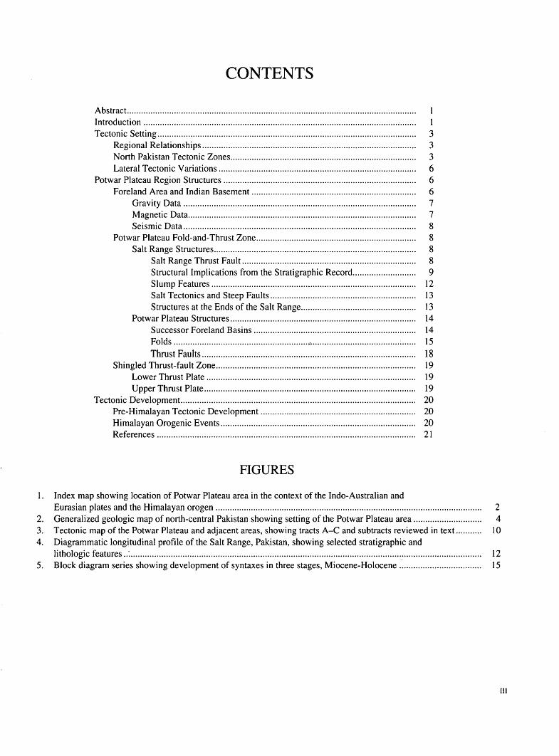
CONTENTS
Abstract........................................................................................................................... 1Introduction.................................................................................................................... 1Tectonic Setting.............................................................................................................. 3
Regional Relationships........................................................................................... 3North Pakistan Tectonic Zones............................................................................... 3Lateral Tectonic Variations.................................................................................... 6
Potwar Plateau Region Structures.................................................................................. 6Foreland Area and Indian Basement...................................................................... 6
Gravity Data................................................................................................... 7Magnetic Data................................................................................................. 7Seismic Data................................................................................................... 8
Potwar Plateau Fold-and-Thrust Zone.................................................................... 8Salt Range Structures...................................................................................... 8
Salt Range Thrust Fault.......................................................................... 8Structural Implications from the Stratigraphic Record........................... 9Slump Features....................................................................................... 12Salt Tectonics and Steep Faults.............................................................. 13Structures at the Ends of the Salt Range................................................. 13
Potwar Plateau Structures............................................................................... 14Successor Foreland Basins..................................................................... 14Folds.........................................................,......................................:...... 15Thrust Faults........................................................................................... 18
Shingled Thrust-fault Zone..................................................................................... 19Lower Thrust Plate......................................................................................... 19Upper Thrust Plate.......................................................................................... 19
Tectonic Development.................................................................................................... 20Pre-Himalayan Tectonic Development.................................................................. 20Himalayan Orogenic Events................................................................................... 20References.............................................................................................................. 21
FIGURES
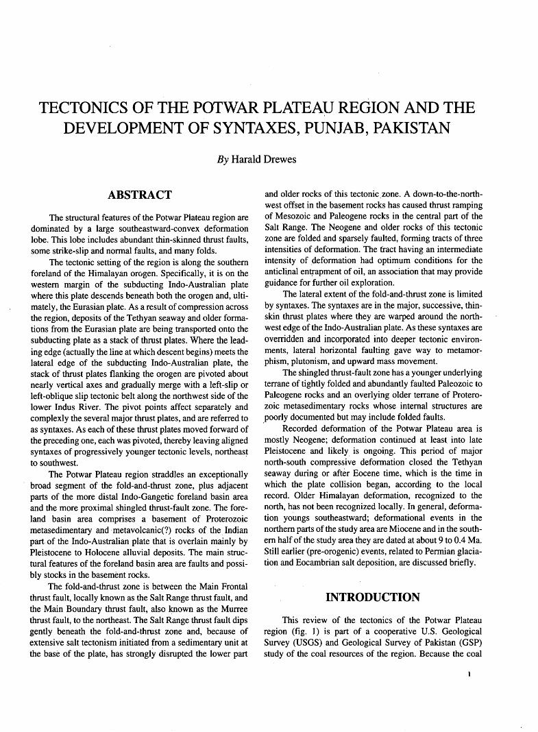
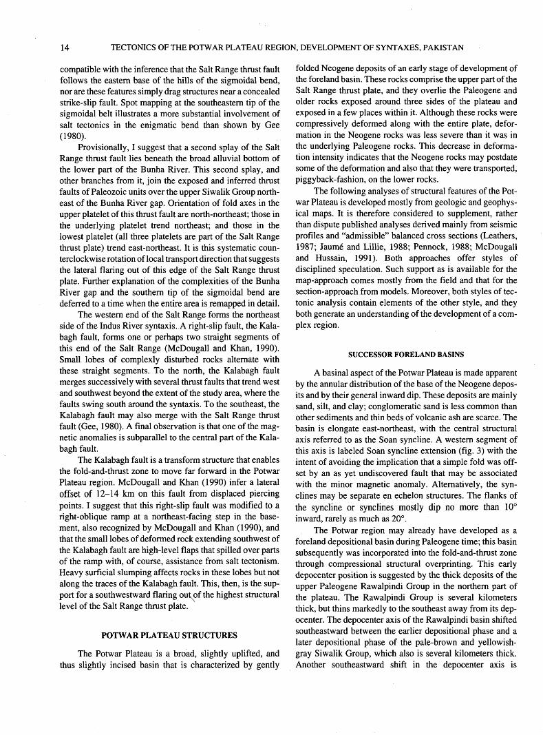
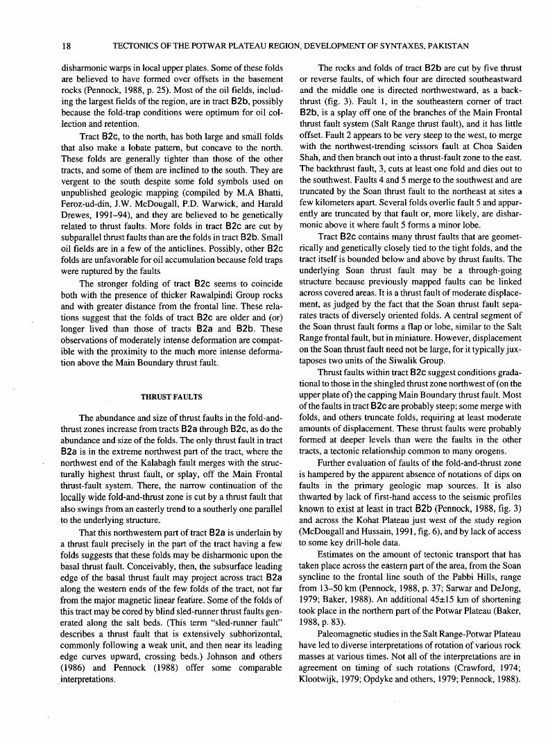
1. Index map showing location of Potwar Plateau area in the context of the Indo-Australian andEurasian plates and the Himalayan orogen ................................................................................................................. 2
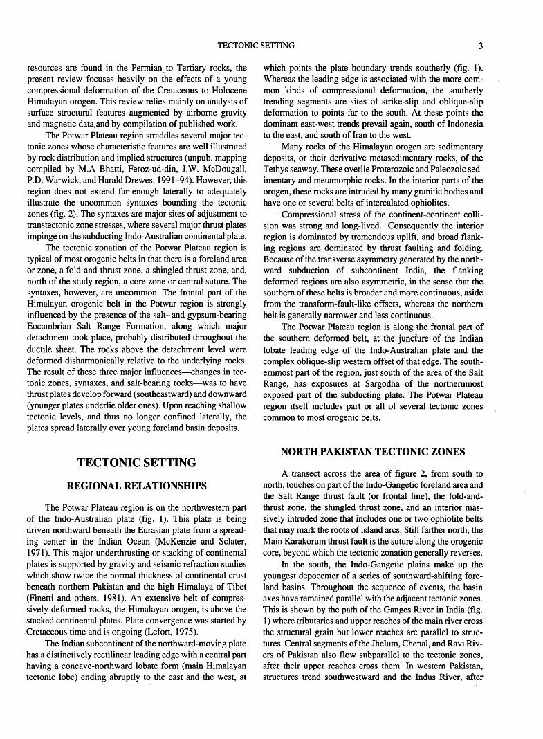
2. Generalized geologic map of north-central Pakistan showing setting of the Potwar Plateau area............................. 43. Tectonic map of the Potwar Plateau and adjacent areas, showing tracts A-C and subtracts reviewed in text........... 104. Diagrammatic longitudinal profile of the Salt Range, Pakistan, showing selected Stratigraphic and
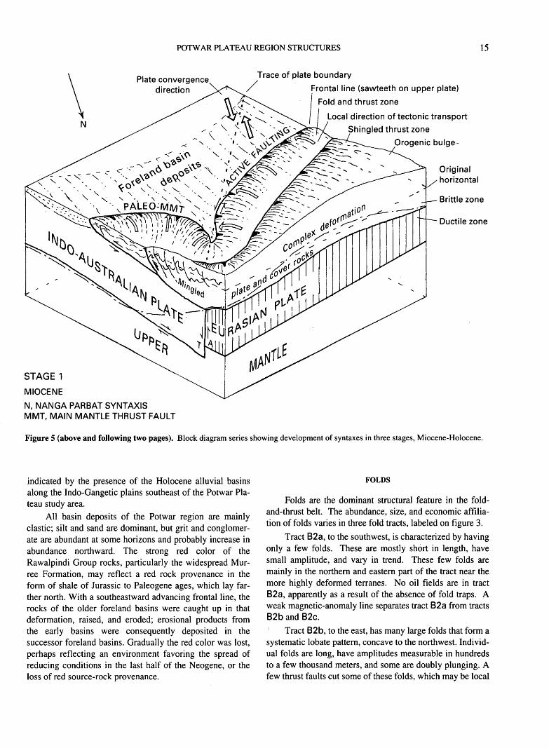
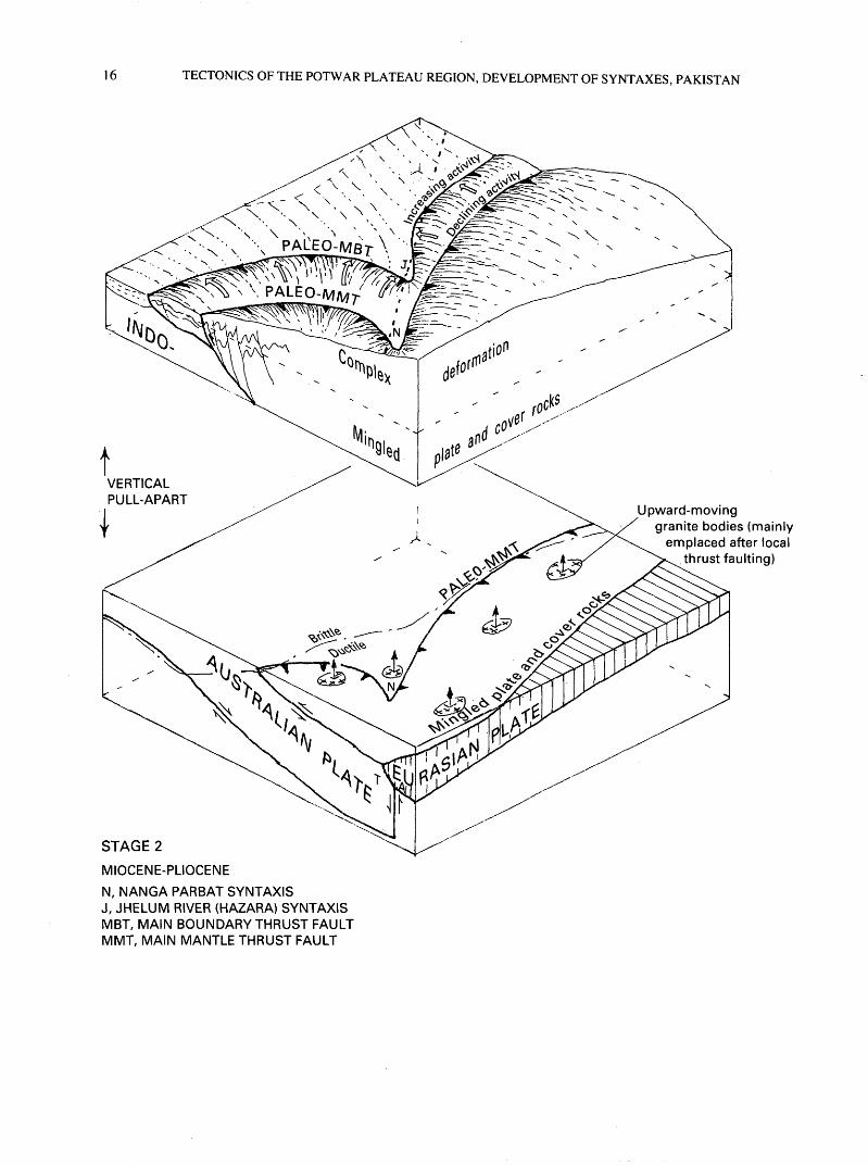
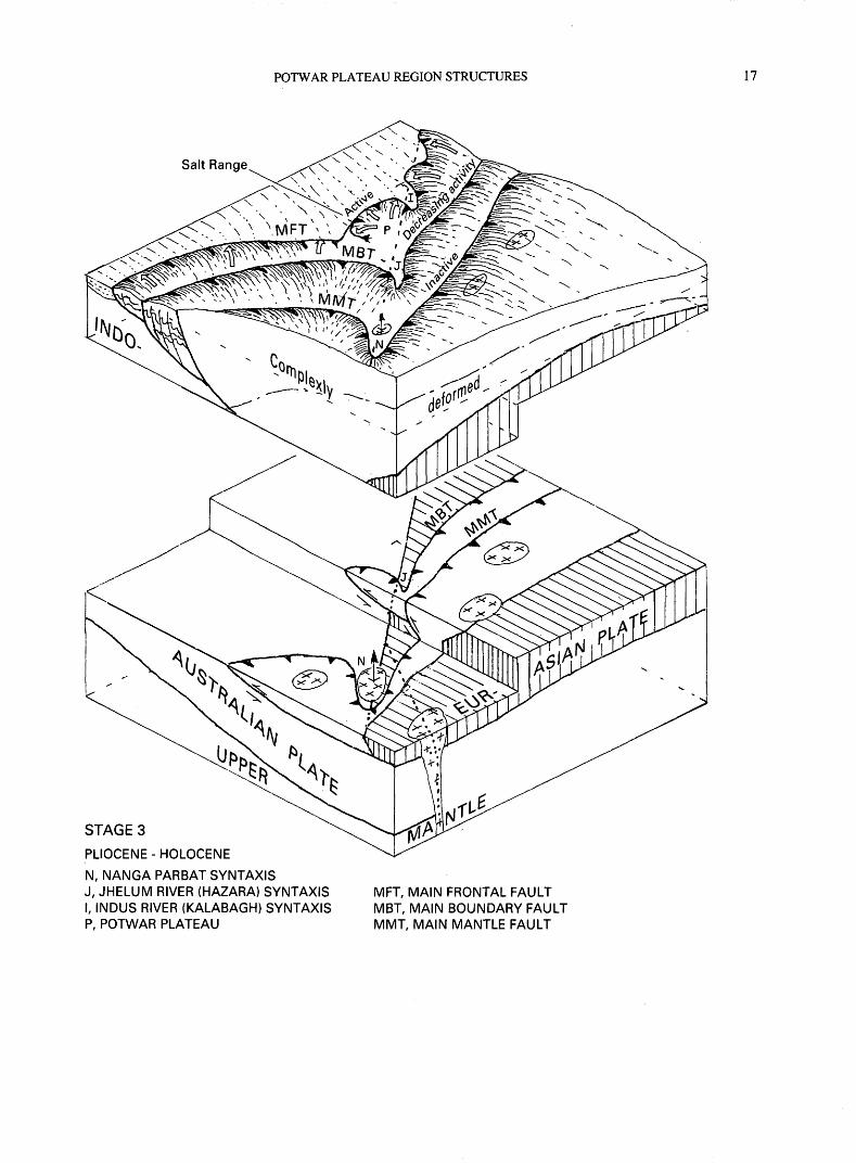
lithologic features..:..................................................................................................................................................... 125. Block diagram series showing development of syntaxes in three stages, Miocene-Holocene ................................... 15
III

TECTONICS OF THE POTWAR PLATEAU REGION AND THE DEVELOPMENT OF SYNTAXES, PUNJAB, PAKISTAN
By Harald Drewes
ABSTRACT
The structural features of the Potwar Plateau region are dominated by a large southeastward-convex deformation lobe. This lobe includes abundant thin-skinned thrust faults, some strike-slip and normal faults, and many folds.
The tectonic setting of the region is along the southern foreland of the Himalayan orogen. Specifically, it is on the western margin of the subducting Indo-Australian plate where this plate descends beneath both the orogen and, ulti mately, the Eurasian plate. As a result of compression across the region, deposits of the Tethyan seaway and older forma tions from the Eurasian plate are being transported onto the subducting plate as a stack of thrust plates. Where the lead ing edge (actually the line at which descent begins) meets the lateral edge of the subducting Indo-Australian plate, the stack of thrust plates flanking the orogen are pivoted about nearly vertical axes and gradually merge with a left-slip or left-oblique slip tectonic belt along the northwest side of the lower Indus River. The pivot points affect separately and complexly the several major thrust plates, and are referred to as syntaxes. As each of these thrust plates moved forward of the preceding one, each was pivoted, thereby leaving aligned syntaxes of progressively younger tectonic levels, northeast to southwest.
The Potwar Plateau region straddles an exceptionally broad segment of the fold-and-thrust zone, plus adjacent parts of the more distal Indo-Gangetic foreland basin area and the more proximal shingled thrust-fault zone. The fore land basin area comprises a basement of Proterozoic metasedimentary and metavolcanic(?) rocks of the Indian part of the Indo-Australian plate that is overlain mainly by Pleistocene to Holocene alluvial deposits. The main struc tural features of the foreland basin area are faults and possi bly stocks in the basement rocks.
The fold-and-thrust zone is between the Main Frontal thrust fault, locally known as the Salt Range thrust fault, and the Main Boundary thrust fault, also known as the Murree thrust fault, to the northeast. The Salt Range thrust fault dips gently beneath the fold-and-thrust zone and, because of extensive salt tectonism initiated from a sedimentary unit at the base of the plate, has strongly disrupted the lower part
and older rocks of this tectonic zone. A down-to-the-north west offset in the basement rocks has caused thrust ramping of Mesozoic and Paleogene rocks in the central part of the Salt Range. The Neogene and older rocks of this tectonic zone are folded and sparsely faulted, forming tracts of three intensities of deformation. The tract having an intermediate intensity of deformation had optimum conditions for the anticlinal entrapment of oil, an association that may provide guidance for further oil exploration.
The lateral extent of the fold-and-thrust zone is limited by syntaxes. The syntaxes are in the major, successive, thin- skin thrust plates where they are warped around the north west edge of the Indo-Australian plate. As these syntaxes are overridden and incorporated into deeper tectonic environ ments, lateral horizontal faulting gave way to metamor- phism, plutonism, and upward mass movement.
The shingled thrust-fault zone has a younger underlying terrane of tightly folded and abundantly faulted Paleozoic to Paleogene rocks and an overlying older terrane of Protero zoic metasedimentary rocks whose internal structures are poorly documented but may include folded faults.
Recorded deformation of the Potwar Plateau area is mostly Neogene; deformation continued at least into late Pleistocene and likely is ongoing. This period of major north-south compressive deformation closed the Tethyan seaway during or after Eocene time, which is the time in which the plate collision began, according to the local record. Older Himalayan deformation, recognized to the north, has not been recognized locally. In general, deforma tion youngs southeastward; deformational events in the northern parts of the study area are Miocene and in the south ern half of the study area they are dated at about 9 to 0.4 Ma. Still earlier (pre-orogenic) events, related to Permian glacia- tion and Eocambrian salt deposition, are discussed briefly.
INTRODUCTION
This review of the tectonics of the Potwar Plateau region (fig. 1) is part of a cooperative U.S. Geological Survey (USGS) and Geological Survey of Pakistan (GSP) study of the coal resources of the region. Because the coal
2 TECTONICS OF THE POTWAR PLATEAU REGION, DEVELOPMENT OF SYNTAXES, PAKISTAN
40' 50' 60' 70' 80' 90' 100' 110'
Potwar Plateau region
otwar Plateau study area
0 R 0 G E N I
/ Hotspot Traces
plate moves North
ST «ALIAN PLAT
To Kerguelen Island
(at latitude of study area]
EXPLANATION
MAJOR TECTONIC BOUNDARY
Thrust fault movement dominant
Strike-slip fault movement dominant
Spreading center Heavy single lines are transform faults; paired light lines are mid-oceanic spreading zone
Tectonic transport direction
Figure 1. Index map showing location of the Potwar Plateau area in context of the Indo-Australian and Eurasian plates and the Himalayan orogen.
TECTONIC SETTING
resources are found in the Permian to Tertiary rocks, the present review focuses heavily on the effects of a young compressional deformation of the Cretaceous to Holocene Himalayan orogen. This review relies mainly on analysis of surface structural features augmented by airborne gravity and magnetic data, and by compilation of published work.
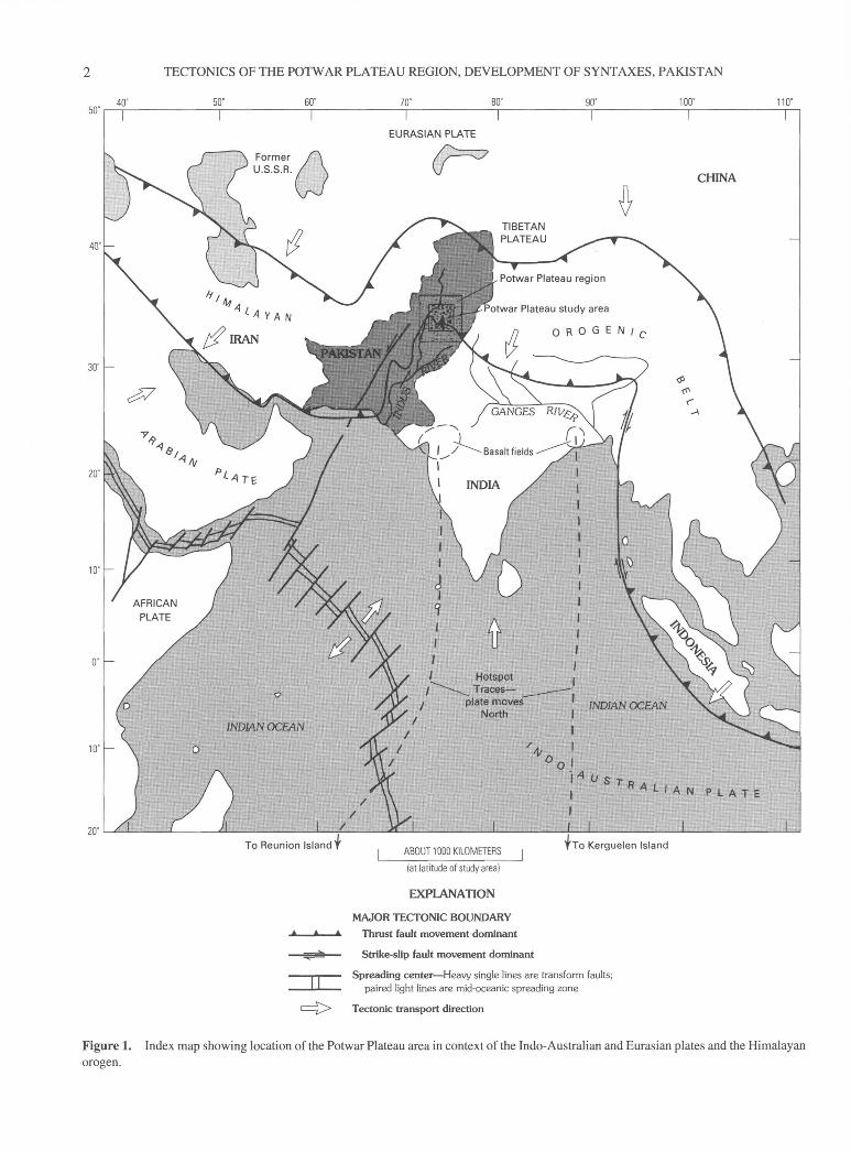
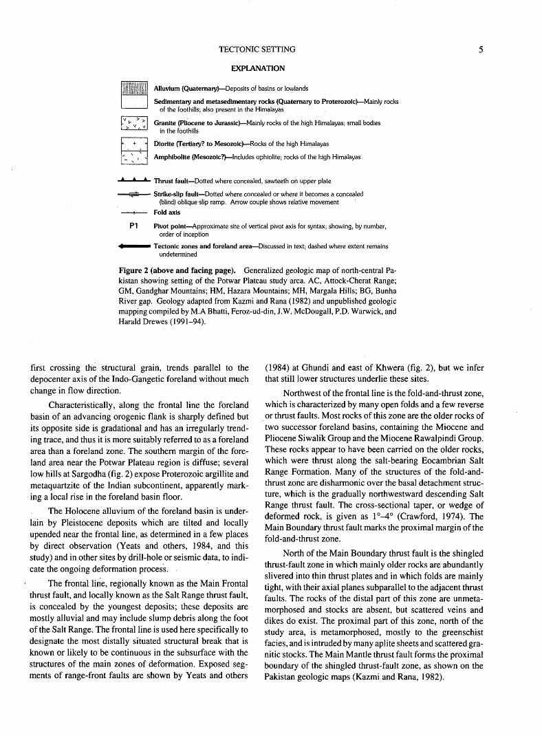
The Potwar Plateau region straddles several major tec tonic zones whose characteristic features are well illustrated by rock distribution and implied structures (unpub. mapping compiled by M.A Bhatti, Feroz-ud-din, J.W. McDougall, P.D. Warwick, and Harald Drewes, 1991-94). However, this region does not extend far enough laterally to adequately illustrate the uncommon syntaxes bounding the tectonic zones (fig. 2). The syntaxes are major sites of adjustment to transtectonic zone stresses, where several major thrust plates impinge on the subducting Indo-Australian continental plate.
The tectonic zonation of the Potwar Plateau region is typical of most erogenic belts in that there is a foreland area or zone, a fold-and-thrust zone, a shingled thrust zone, and, north of the study region, a core zone or central suture. The syntaxes, however, are uncommon. The frontal part of the Himalayan erogenic belt in the Potwar region is strongly influenced by the presence of the salt- and gypsum-bearing Eocambrian Salt Range Formation, along which major detachment took place, probably distributed throughout the ductile sheet. The rocks above the detachment level were deformed disharmonically relative to the underlying rocks. The result of these three major influences changes in tec tonic zones, syntaxes, and salt-bearing rocks was to have thrust plates develop forward (southeastward) and downward (younger plates underlie older ones). Upon reaching shallow tectonic levels, and thus no longer confined laterally, the plates spread laterally over young foreland basin deposits.
TECTONIC SETTING
REGIONAL RELATIONSHIPS
The Potwar Plateau region is on the northwestern part of the Indo-Australian plate (fig. 1). This plate is being driven northward beneath the Eurasian plate from a spread ing center in the Indian Ocean (McKenzie and Sclater, 1971). This major underthrusting or stacking of continental plates is supported by gravity and seismic refraction studies which show twice the normal thickness of continental crust beneath northern Pakistan and the high Himalaya of Tibet (Finetti and others, 1981). An extensive belt of compres- sively deformed rocks, the Himalayan orogen, is above the stacked continental plates. Plate convergence was started by Cretaceous time and is ongoing (Lefort, 1975).
The Indian subcontinent of the northward-moving plate has a distinctively rectilinear leading edge with a central part having a concave-northward lobate form (main Himalayan tectonic lobe) ending abruptly to the east and the west, at
which points the plate boundary trends southerly (fig. 1). Whereas the leading edge is associated with the more com mon kinds of compressional deformation, the southerly trending segments are sites of strike-slip and oblique-slip deformation to points far to the south. At these points the dominant east-west trends prevail again, south of Indonesia to the east, and south of Iran to the west.
Many rocks of the Himalayan orogen are sedimentary deposits, or their derivative metasedimentary rocks, of the Tethys seaway. These overlie Proterozoic and Paleozoic sed imentary and metamorphic rocks. In the interior parts of the orogen, these rocks are intruded by many granitic bodies and have one or several belts of intercalated ophiolites.
Compressional stress of the continent-continent colli sion was strong and long-lived. Consequently the interior region is dominated by tremendous uplift, and broad flank ing regions are dominated by thrust faulting and folding. Because of the transverse asymmetry generated by the north ward subduction of subcontinent India, the flanking deformed regions are also asymmetric, in the sense that the southern of these belts is broader and more continuous, aside from the transform-fault-like offsets, whereas the northern belt is generally narrower and less continuous.
The Potwar Plateau region is along the frontal part of the southern deformed belt, at the juncture of the Indian lobate leading edge of the Indo-Australian plate and the complex oblique-slip western offset of that edge. The south ernmost part of the region, just south of the area of the Salt Range, has exposures at Sargodha of the northernmost exposed part of the subducting plate. The Potwar Plateau region itself includes part or all of several tectonic zones common to most orogenic belts.
NORTH PAKISTAN TECTONIC ZONES
A transect across the area of figure 2, from south to north, touches on part of the Indo-Gangetic foreland area and the Salt Range thrust fault (or frontal line), the fold-and- thrust zone, the shingled thrust zone, and an interior mas sively intruded zone that includes one or two ophiolite belts that may mark the roots of island arcs. Still farther north, the Main Karakorum thrust fault is the suture along the orogenic core, beyond which the tectonic zonation generally reverses.
In the south, the Indo-Gangetic plains make up the youngest depocenter of a series of southward-shifting fore land basins. Throughout the sequence of events, the basin axes have remained parallel with the adjacent tectonic zones. This is shown by the path of the Ganges River in India (fig. 1) where tributaries and upper reaches of the main river cross the structural grain but lower reaches are parallel to struc tures. Central segments of the Jhelum, Chenal, and Ravi Riv ers of Pakistan also flow subparallel to the tectonic zones, after their upper reaches cross them. In western Pakistan, structures trend southwestward and the Indus River, after
TECTONICS OF THE POTWAR PLATEAU REGION, DEVELOPMENT OF SYNTAXES, PAKISTAN
71' IT 73* 74' 75'
POTWAR PLATEAU STUDY AREA
33'
32'
TECTONIC SETTING
EXPLANATION
Alluvium (Quaternary) Deposits of basins or lowlands
Sedimentary and metasedimentary rocks (Quaternary to Proterozoic) Mainly rocks of the foothills; also present in the Himalayas
Granite (Pliocene to Jurassic) Mainly rocks of the high Himalayas; small bodies in the foothills
Diorite (Tertiary? to Mesozolc) Rocks of the high Himalayas
Amphibollte (Mesozoic?) Includes ophiolite; rocks of the high Himalayas
Thrust fault Dotted where concealed, sawteeth on upper plate
Strike-slip fault Dotted where concealed or where it becomes a concealed (blind) oblique-slip ramp. Arrow couple shows relative movement
Fold axis
Pivot point Approximate site of vertical pivot axis for syntax; showing, by number, order of inception
^^^"^ Tectonic zones and foreland area Discussed in text; dashed where extent remains undetermined
Figure 2 (above and facing page). Generalized geologic map of north-central Pa kistan showing setting of the Potwar Plateau study area. AC, Attock-Cherat Range; GM, Gandghar Mountains; HM, Hazara Mountains; MH, Margala Hills; BG, Bunha River gap. Geology adapted from Kazmi and Rana (1982) and unpublished geologic mapping compiled by M.A Bhatti, Feroz-ud-din, J.W. McDougall, P.D. Warwick, and Harald Drewes (1991-94).
P1
first crossing the structural grain, trends parallel to the depocenter axis of the Indo-Gangetic foreland without much change in flow direction.
Characteristically, along the frontal line the foreland basin of an advancing orogenic flank is sharply defined but its opposite side is gradational and has an irregularly trend ing trace, and thus it is more suitably referred to as a foreland area than a foreland zone. The southern margin of the fore land area near the Potwar Plateau region is diffuse; several low hills at Sargodha (fig. 2) expose Proterozoic argillite and metaquartzite of the Indian subcontinent, apparently mark ing a local rise in the foreland basin floor.
The Holocene alluvium of the foreland basin is under lain by Pleistocene deposits which are tilted and locally upended near the frontal line, as determined in a few places by direct observation (Yeats and others, 1984, and this study) and in other sites by drill-hole or seismic data, to indi cate the ongoing deformation process.
The frontal line, regionally known as the Main Frontal thrust fault, and locally known as the Salt Range thrust fault, is concealed by the youngest deposits; these deposits are mostly alluvial and may include slump debris along the foot of the Salt Range. The frontal line is used here specifically to designate the most distally situated structural break that is known or likely to be continuous in the subsurface with the structures of the main zones of deformation. Exposed seg ments of range-front faults are shown by Yeats and others
(1984) at Ghundi and east of Khwera (fig. 2), but we infer that still lower structures underlie these sites.
Northwest of the frontal line is the fold-and-thrust zone, which is characterized by many open folds and a few reverse or thrust faults. Most rocks of this zone are the older rocks of two successor foreland basins, containing the Miocene and Pliocene Siwalik Group and the Miocene Rawalpindi Group. These rocks appear to have been carried on the older rocks, which were thrust along the salt-bearing Eocambrian Salt Range Formation. Many of the structures of the fold-and- thrust zone are disharmonic over the basal detachment struc ture, which is the gradually northwestward descending Salt Range thrust fault. The cross-sectional taper, or wedge of deformed rock, is given as l°-4° (Crawford, 1974). The Main Boundary thrust fault marks the proximal margin of the fold-and-thrust zone.
North of the Main Boundary thrust fault is the shingled thrust-fault zone in which mainly older rocks are abundantly slivered into thin thrust plates and in which folds are mainly tight, with their axial planes subparallel to the adjacent thrust faults. The rocks of the distal part of this zone are unmeta- morphosed and stocks are absent, but scattered veins and dikes do exist. The proximal part of this zone, north of the study area, is metamorphosed, mostly to the greenschist facies, and is intruded by many aplite sheets and scattered gra nitic stocks. The Main Mantle thrust fault forms the proximal boundary of the shingled thrust-fault zone, as shown on the Pakistan geologic maps (Kazmi and Rana, 1982).
TECTONICS OF THE POTWAR PLATEAU REGION, DEVELOPMENT OF SYNTAXES, PAKISTAN
The interior or hinterland zone has the highest meta- morphic grade (mostly greenschist in the study area) of metasedimentary and meta-igneous rock, which are mas sively invaded by granitic, dioritic, and ophiolitic rocks. Rocks of this interior zone are uplifted and deeply eroded. Continued present-day uplift is indicated by local relief of 4 km, by the young (5-8 Ma) cooling ages of the rock, and by the signs of young faulting (Treloar and others, 1991) that are exceptions to the general southward younging of com- pressive deformation.
LATERAL TECTONIC VARIATIONS
The systematic tectonic zonation of a transect through the Potwar Plateau area is common to many parts of the southern flank of the Himalayan orogen, but some structural variations also exist laterally along the orogenic belt. Fur thermore, the fold-and-thrust zone of India is narrower (about 50 km) than it is in the Potwar region (about 180 km), which probably reflects an increase in the cross-sectional taper in India to as much as 8° (Acharyya and Ray, 1982).
The largest features of lateral variation are the trans form-fault-like major offsets of the entire orogen, such as on the lateral margins of the Indian subcontinental part of the plate. The eastern offset of these major features is probably a right-lateral fault, and is of little concern here because it is far away in Assam and Bangladesh. However, the western offset extends southwestward, from the west side of the Pot- war Plateau study area, as an alternation of left-lateral faults and fold-and-thrust-zone lobes. Apparently, the subducting part of the Indo-Australian plate is moving obliquely to the trend of these surface structures, resulting in a skewed struc tural pattern. The first of the minor lobate fronts is just south west of Mianwali (fig. 2), separated from the Salt Range lobe by the Kalabagh reentrant, a structural embayment referred to as a syntaxis.
Syntaxes are remarkable transverse structures of mod erate scale that show the existence of pivotal movement about a vertical axis, generally analogous to the closing of an open nutcracker lying flat on a table. Local movements recorded on the three syntaxes shown on figure 2 are com plex and young; movement is "complex" because of the vari ation of movement from site to site in any one syntaxis.
The Indus River syntaxis (Kalabagh syntaxis; PS on fig. 2) centers on the structural and topographic embayment along the segment of the Indus River west of the Salt Range. It is underlain by Pleistocene-Holocene deposits upon which adjacent Tertiary and older rocks are being pushed. Its upper bounding fault seems to be along, or slightly above, the Main Frontal thrust-fault system. The Indus River syntaxis seems, then, to be a lateral flaring out at the high structural level of the most forward part of the deforming rocks. Perhaps the upward flowage of salt or gypsum in geophysically identi fied stocks near Mianwali (Drewes and Ahmad, in press) is fostered or enhanced by such lateral compression. The
Kalabagh fault, bounding this syntaxis to the east, is described in a following section.
The Jhelum River syntaxis (?2 on fig. 2; in some accounts the Hazara syntaxis) is at a higher tectonic level, involving rocks between the Main Frontal thrust fault and the Panjal thrust fault (fig. 3 on pages 10-11), essentially all of the fold-and-thrust-zone rocks and the distal part of the shingled thrust-fault zone. It bounds the study area to the east near Murree and is a few kilometers east of the southern part of the area. The western side of this syntaxis is customarily shown as a left-lateral fault which offsets the Siwalik Group and some internal small thrust faults, as well as the Main Boundary thrust fault (Kazmi and Rana, 1982).
The Nanga Parbat syntaxis (P-| on fig. 2) is in higher tectonic levels than the Jhelum River syntaxis, although it involves mostly older gneiss plus granitic rocks that have young cooling ages (Treloar and others, 1991). In this case, the main movement recorded on the structures bounding the syntaxis is vertical, although in places oblique-slip move ment is noted. But even here the vertical movement is cou pled with an upward and outward lateral sense of flowage that reflects the "nutcracker" effect in the rocks of the plate between the Panjal and Main Mantle thrust faults (fig. 2).
The three syntaxes of the Potwar Plateau region proba bly developed in response to concurrent thrust faulting and adjustment of major thrust plates around the northwest edge of the subducting plate. The pivot points of the syntaxes are aligned, not only with one another, but also with the south west trend of the orogenic belt along the western strike-slip margin of the Indian subcontinent part of the plate. Further more, from northeast to southwest, the pivot points shift sys tematically to lower-level younger plates. Apparently then, as the frontal line shifted forward along a newly developed thrust system in younger and younger rocks, ultimately in successor foreland basin deposits, the rotation of the deform ing rocks around the edge of the subducting plate affected the younger plates, too. Each major plate was bent, or rotated, in sequence.
POTWAR PLATEAU REGION STRUCTURES
Selected structural features of the three tectonic zones represented in the study area are reviewed from southeast to northwest. Geophysically determined structural features attributed to the subducting plate are mostly discussed with the foreland features, even though they are beneath more proximal positions.
FORELAND AREA AND INDIAN BASEMENT
The foreland area, southeast of the Salt Range and extending into the Indus River syntaxis, provides little
POTWAR PLATEAU REGION STRUCTURES
surface data on its structural condition. The frontal line is concealed by the youngest alluvial deposits of the Jhelum and Indus Rivers and by a combination of alluvial fans, aprons, and slump deposits at the base of the Salt Range.
At several sites young deposits near the frontal line are folded or tilted, indicating that deformation is extremely young. Indeed, in the Pabbi Hills, east of the Salt Range and south of Jhelum (fig. 2), a drill hole that penetrated a thrust fault underlying a gentle anticline in the upper part of the Siwalik Group was sheared by late movement on the fault. By the definition used here for the recognition of the frontal line the most proximal fault having structural continuity with the main deformed belt the Pabbi Hills are in the fold- and-thrust zone rather than the foreland area, and the frontal line is concealed south of those hills. Therefore, the thrust faults at the east end of the Salt Range, near the sigmoidal bend of the range front (fig. 2), and those faults northwest of Jhelum are splay faults off the underlying extension of the Salt Range thrust fault. The splay faults are informative about the condition of the rocks at the northern edge of the foreland area. These rocks are being folded and almost simultaneously faulted, thereby being incorporated into the fold-and-thrust zone.
Signs of young anticlinal warping also exist at a site near Lilla, a few kilometers southeast of the central part of the Salt Range (fig. 3). According to Lillie and others (1987), drill-hole data show Pleistocene(?) rocks are arched, possi bly over a salt core, at shallow depth beneath alluvial cover.
Northwest of Kalabagh, Pleistocene rocks are also faulted and upended, and again the question arises as to pre cisely where to place the frontal line. The Surghar Range thrust fault of McDougall and Hussain (1991) is the south ernmost exposed thrust fault of those faults west of the Kal abagh right-lateral fault. Along this thrust fault, Jurassic to Paleogene rocks are placed upon the Neogene Siwalik Group. This thrust fault may be the extension of the Salt Range thrust fault, and thus the apparent frontal line, but it is also possible that a still lower, concealed structure underlies the Siwalik Group and some Kalabagh Conglomerate, and that this postulated still lower structure trends around the head of the Indus River syntaxis, to form the real frontal line.
Airborne gravity and magnetic maps provide indirect evidence of structures underlying the foreland area, as well as the adjacent part of the fold-and-thrust zone. The basic gravity data are from Oil and Gas Development Corporation (OGDC) reports, cited in the following sections. While geo physical anomalies may show the existence of structural fea tures in the subsurface, their absence need not deny the presence of structures, which are recognizable only where they are associated with certain magnetic or gravity contrasts.
GRAVITY DATA
The gravity maps of Waheed-ud-din (1967, 1971) and Waheed-ud-din and Lotyshev (1970) show relatively high density rocks (near the surface?) in the northwestern part of
the Potwar Plateau region and progressively more low-den sity rocks (near the surface?) to the southeast. This system atic variation across the region probably reflects the presence in outcrop of the Proterozoic metasedimentary rocks in the Attock-Cherat Range and Gandghar and Hazara Mountains, Paleozoic and Mesozoic sedimentary rocks in the next ranges to the southeast, such as the Kala Chitta Range and Margala Hills, weakly indurated Tertiary rocks across the Potwar Plateau, and, excepting for the Salt Range, alluvium in the foreland area to the southeast.
This general gravity gradient is interrupted by two minor reversals (gravity anomaly lines G, the one north of Pindi Gheb and the other south of Chakwal, fig. 3), which suggest the presence in the subsurface of raised masses of denser, and thus probably older, rocks northwest of the grav ity anomaly lines. These lines are inferred to be reverse fault segments of the thrust fault, which are ramped up across off sets on a flat-lying fault system. The inferred offset must be young to have affected movement on the Salt Range thrust fault in the subsurface. The pattern of these inferred faults is similar to that of the magnetic features found southeast of the frontal line, and so the young offset of the basement rocks marked by gravity anomalies may be reactivated structures.
The southernmost linear gravity feature is offset in three places, and from west to east the segments were shifted southward. The significance of these offsets may be under stood from the magnetic data.
MAGNETIC DATA
The airborne magnetic map of Voskresensky (1965) shows tracts of diverse magnetic patterns and linear zones of anomalies that imply structural control. Interpretations of these patterns and linear zones are illustrated in figure 3. The most prominent feature is a steep linear magnetic anomaly that extends northwest from the northeast side of the Sar- godha Hills (fig. 2), through the Salt Range north of Kushab (fig. 3), across the western part of the Potwar Plateau, and to the Indus River a few kilometers north of its junction with the Soan River. The southeastern third of the block northeast of this linear magnetic structure has a distinctive pattern of closely spaced magnetic highs and lows, typical of volcanic or volcanogenic terrane, such as the argillite or sub- gray wacke of the Sargodha Hills. The same magnetic pattern occurs farther northwest on the southwestern block, suggest ing a right-slip offset of many kilometers.
Small, linear, west-northwest-trending magnetic anom alies merge with the main linear features in the foreland area, resembling either splay faults off a master fault, older offset cross faults, or both. The manner in which merging features join suggests right-lateral drag along the main linear feature.
One of the offsets of the southern linear gravity anom alies coincides with the position of the main magnetic linear feature, thereby giving further support to a right-slip offset on the main linear feature.
TECTONICS OF THE POTWAR PLATEAU REGION, DEVELOPMENT OF SYNTAXES, PAKISTAN
The magnetic data suggest that the main magnetic lin ear is a right-lateral fault in the basement rocks. The fault left a stronger signature to the southeast, where basement rocks approach the surface, than to the northwest, where basement rock underlies a thickening thrust plate.
One of the minor magnetic splays (faults?) crosses the Kalabagh fault (southwest corner of figure 3) at a low angle. Another minor magnetic feature also trends northwest, sub- parallel to, and northeast of the major inferred fault. The southeastern segment of the major inferred fault crosses the southern gravity anomaly at another of its offsets. Its central segment is arcuate and is near a line at the surface along which fold axes end or change trend. Its northwestern seg ment follows a segment of the Soan thrust fault that trends anomalously southeast. The significance of this minor mag netic splay is unclear.
SEISMIC DATA
Refraction seismic data were made available to the staff and students of the University of Oregon, providing them with a basis of some useful tectonic interpretations of a sub surface ramp (Lillie and Yousuf, 1986; Lillie and others, 1987; Baker, 1988;Pennock, 1988;McDougallandHussain, 1991). Because the published reproductions of these seismic records have lost much in detail, only some of the major fea tures are discussed in this report. Of prime significance among these is the evidence of an offset of 1 km, down to the northwest of basement rock along the central part of the northwest flank of the Salt Range (Baker, 1988; Baker and others, 1988). This basement offset is in the same place that offsets are shown by the gravity and magnetic data (fig. 3). The inference and cause for development of a ramp structure in this area is thus well founded.
Earthquake seismicity provides evidence of low-mag nitude ongoing activity along the Salt Range (Seeber and Jacob, 1977). The low magnitude of activity contrasts mark edly with strong seismicity along the frontal line to the east in India (Quittmeyer and Jacob, 1979; Seeber and others, 1981). This contrast in seismicity is believed by them to reflect a change along the Main Frontal thrust fault from ductile salt-bearing rocks in Pakistan to more competent clastic rocks in India. In the salt beds, distributed slip may dissipate the energy incrementally rather than forming major earthquakes.
POTWAR PLATEAU FOLD-AND-THRUST ZONE
The fold-and-thrust zone is exceptionally broad (180 km) in the study region and is characterized by its
well-developed lobate plan view. The zone has two distinctive entities, a lower structural assemblage domi nated by the Salt Range rocks and structures, and an upper structural assemblage mainly of younger rocks and their characteristic open folds. These structural enti ties comprise a major thrust plate that overlies the Salt Range thrust fault (a segment of the Main Frontal thrust fault) and underlies the Main Boundary thrust fault (known locally as the Murree thrust fault). Most struc tural features are of Pliocene and Pleistocene age, and those along the Salt Range thrust fault are probably Holocene and, at least locally, are still active.
SALT RANGE STRUCTURES
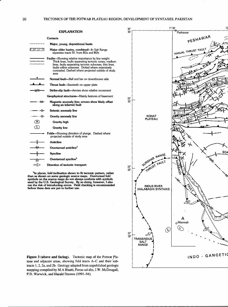
The structural features of the Salt Range (tract Bl, fig. 3) and of the northerly trending extensions of both ends of the range are dominated by salt tectonics, as illustrated by the series of geologic maps by Gee (1980) and summarized in unpublished mapping compiled by M.A Bhatti, Feroz-ud- din, J.W. McDougall, P.O. Warwick, and Harald Drewes (1991-94). This occurrence of salt (herein generally meant to include gypsum and anhydrite) has affected in diverse ways the thrust faults, normal and reverse faults and slump features, all of the Salt Range-Potwar thrust plate, as well as the complex structures at the ends of the Salt Range. The characteristics of the Salt Range thrust fault particularly are a result of the distribution of salt.
SALT RANGE THRUST FAULT
The oldest rocks of the Salt Range are the Eocambrian Salt Range Formation. The Salt Range Formation consists of marlstone, clay, salt, anhydrite, and some siltstone and carbonate rocks, an assemblage that is structurally very incompetent and varies widely in thickness due to salt flow- age. Over extensive subsurface tracts this thickness is in the range of many hundreds to two thousand meters thick, but at the surface the base of the formation is not exposed and so the local thickness is unknown. This formation is pre sumed to overlie the thick, mildly metamorphosed, and very competent rocks of Proterozoic age that are part of the Indo-Australian plate.
In a general sense, the Salt Range thrust fault separates the Eocambrian from the Proterozoic rocks. The presence of this thrust fault is inferred from abundant disharmonic struc tures between the plates, from the seismic refraction records, the seismicity data, and from the intensely deformed condi tion of the rocks directly above the concealed fault. In a few sites, segments of the Salt Range thrust fault have been inferred to be present, as for example along the foot of the range 30 km northeast of Mianwali (fig. 2). These segments
POTWAR PLATEAU REGION STRUCTURES
likely represent only subordinate structures to those in the nearby subsurface, although their local stratigraphic throw is large. Even if other, larger, subhorizontal faults are found in the nearby subsurface, they may be segments or splays of a master fault that is obliterated because of salt flowage. Although ductile deformation would prevail, shear planes would probably occur in the nonsaline rocks from which salt may have flowed; those fault segments likely would end against masses of salt accumulation, in which erratic flow- age features would prevail. It is also possible that segments of extensive discrete fault planes exist at the base of the Salt Range Formation where the greatest contrast in structural strength of the rocks occurs. In either case, the Salt Range thrust fault emplaces Eocambrian (younger) rocks upon Pro- terozoic (older) rocks.
Faults of such distributive characteristics are carto- graphically difficult to illustrate. Conventionally, a standard fault line is used, and this has been done in nearly all the pub lished maps and structure sections of the Salt Range, includ ing those of figure 3 in this report. Pennock (1988) tries to convey the concept of distributed movement along a wide fault zone through the use of a dotted heavy line placed within the Salt Range Formation, a scheme I have restricted to depicting high-angle faults intruded by salt-bearing rock.
The Salt Range thrust fault underlies surficial deposits near the southeastern front of the Salt Range, where its pre cise position remains unknown. Beneath these deposits, but still near the surface, seismic evidence shows that the fault dips moderately steeply north-northwestward down to a depth of a few kilometers (Baker, 1988; Pennock, 1988). There, the fault flattens to dips of only a few degrees and extends beneath most of the Salt Range, where the Salt Range Formation (probably the zone of distributive shear or flowage) is 1-2 km thick.
Beneath the northwest flank of the Salt Range, the dip of the Salt Range thrust fault (or Salt Range Formation) steepens again and the contact at the top of Proterozoic base ment rock drops about 1 km. The Salt Range thrust plate is ramped across this step in the basement. The position of this ramp is shown in figure 3 by the seismic anomaly line, S, and its closely associated gravity anomaly line, G. These anomaly lines appear to slightly diverge in the west where the seismic data ends, perhaps reflecting the distribution of masses of the Salt Range Formation of diverse thickness near the basement offset.
Northwest of the concealed structural ramp, the Salt Range thrust fault flattens again and dips a few degrees northwest. In the eastern part of the study area, the existence and position of this part of the fault is known as far north westward as the axis of the Soan syncline. Deep seismic profiles were either not made over the western part of the fault or were not available to us.
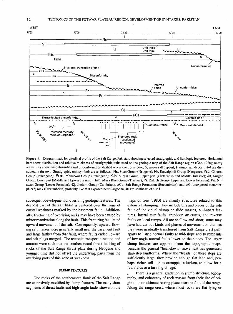
STRUCTURAL IMPLICATIONS FROM THE STRATIGRAPHIC RECORD
Stratigraphic data along the Salt Range, from southwest to northeast, provide some information on early structural development of the region (fig. 4). The sequence of Permian through Cretaceous map units (fig. 4, a) are systematically truncated to the east by an unconformity (fig. 4, b). A west ward tilting of the beds during Late Cretaceous or earliest Paleogene time is indicated by these geologic relationships. Possibly this tilting reflects the uplift of the advancing oro- genic front of the western part of the main Himalayan tectonic lobe.
Paleogene formations are also erosionally truncated in the eastern Salt Range (fig. 4, c). This higher unconformity separates the Paleogene units from overlying Neogene units. This unconformity implies a renewed encroachment of the Himalayan tectonic lobe and the consequent uplift of the region northeast of the Potwar region, possibly involving the early stages of development of the Nanga Parbat syntaxis (fig- 5).
Both the upper Paleogene unit, PEC, and the lower Neo gene unit, Nr, thicken in the central part of the Salt Range (fig. 4, d) and thin to the east and west. This thickening of deposits may be due to a sag in this part of the floor of these basins, a feature that may reflect reactivation of fault move ment along a major basement structure and consequent loss of salt through outward or upward flowage.
The Eocambrian Salt Range Formation (eCs) and Cambrian Jhelum Group (Cj) thicken east of a position along the Salt Range near longitude 73° (fig. 4, e). Too little is known of the thickness of these sequences to the east of the study area to draw inferences from these thickness changes. However, all the occurrences of salt shown on the maps of Gee (1980), plus the major salt deposit at Kalabagh, are west of this site of thickness change. Possibly, then, the part of the Salt Range west of site e marks a more central segment of the original salt basin.
The distribution of major salt deposits along the Salt Range may reflect variations in structural controls. Known large salt deposits are shown on figure 4 as S and known or inferred small deposits as S. The small size of these deposits is only inferable through the absence of major mining oper ations in them, a situation that may reflect nongeologic fac tors as well as actual deposit size. These "small" deposits are between longitudes 72° 15' and 72°45'. Both to the east and west of this cluster of small salt deposits, and beyond a gap of 15', are the large salt deposits, respectively, of Khwera and Warchha. The small salt deposits are generally coexten sive with the inferred sag in the Paleogene (ftc) and Neo gene (Nr) basins of sedimentation.
In the basement rocks, the major right-slip fault believed to be shown by offsets in geophysical data along a northwest-trending line, crosses the Salt Range near longi tude 72°30' (figs. 3 and 4, f). That fault may have influenced
10 TECTONICS OF THE POTWAR PLATEAU REGION, DEVELOPMENT OF SYNTAXES, PAKISTAN
-M-
-S-
.-G-
EXPLANATION
Contacts
Major, young, depositional basin
Major older basins, combined In Salt Range separates tracts Bl from B2a and B2b
Faults Showing relative importance by line weight.Thick lines, faults separating tectonic zones; medium lines, faults separating tectonic subzones; thin lines, faults within subzones. Dotted where extensively concealed. Dashed where projected outside of study area
Normal fault Ball and bar on downthrown side
Thrust fault Sawteeth on upper plate
Strike-slip fault Arrows show relative movement
Geophysical structures Mainly features of basement
Magnetic anomaly line; arrows show likely offset along an inferred fault
-y-
Folds Showing direction of plunge. Dashed where projected outside of study area
Anticline
Overturned anticline1
Syncline
Overturned syncline1
Direction of tectonic transport
1In places, fold inclination shown to fit tectonic pattern, rather than as shown on some geologic source maps. Overturned fold symbols on the source maps do not always conform with symbols used by the U.S. Geological Survey. By so doing, however, I also run the risk of introducting errors. Held checking is recommended before these data are put to further use.
Figure 3 (above and facing). Tectonic map of the Potwar Pla teau and adjacent areas, showing fold tracts A-C and their sub tracts 1,2,2a, and 2b. Geology adapted from unpublished geologic mapping compiled by M.A Bhatti, Feroz-ud-din, J.W. McDougall, P.D. Warwick, and Harald Drewes (1991-94).
INDUS RIVER (KALABAGH) SYNTAXIS

72*30'
POTWAR PLATEAU REGION STRUCTURES
73°00'
11
73*30'
JHELUM RIVER (HAZARA) SYNTAXIS
FORELAND
100 KILOMETERS
12 TECTONICS OF THE POTWAR PLATEAU REGION, DEVELOPMENT OF SYNTAXES, PAKISTAN
WEST
7T30' 72°00' 72°30' 73°00'EAST
73°30'
-Ns- Nr
PEC
Unit thick/ Unit thin.
PEm
Erosional truncation of unitUnconformities
Inferredtilting Unconformities
b
Metasedimentary rocks of Sargodha?
Fractured rock, reactivated movement?
Figure 4. Diagrammatic longitudinal profile of the Salt Range, Pakistan, showing selected stratigraphic and lithologic features. Horizontal bars show distribution and relative thickness of stratigraphic units used on the geologic map of the Salt Range region (Gee, 1980); heavy wavy lines show unconformities and disconformities, dashed where control is poor; S, major salt deposit; S, minor salt deposit; a-f are dis cussed in the text. Stratigraphic unit symbols are as follows: Ns, Soan Group (Neogene); Mr, Rawalpindi Group (Neogene); PEC, Chharat Group (Paleogene); PEITI, Makerwal Group (Paleogene); KJs, Surgar Group, upper part (Cretaceous and Middle Jurassic); Js, Surgar Group, lower part (Middle and Lower Jurassic); ~6m, Musa Khel Group (Triassic); Pz, Zaluch Group (Upper and Lower Permian); Pn, Nil- awan Group (Lower Permian); Cj, Jhelum Group (Cambrian); eCs, Salt Range Formation (Eocambrian); and pC, unexposed metamor- phic(?) rock (Precambrian) probably like that exposed near Sargodha, 40 km southeast of site f.
subsequent development of overlying geologic features. The deepest part of the salt basin is centered over the zone of crustal weakness marked by the basement fault. Addition ally, fracturing of overlying rocks may have been caused by minor reactivation along the fault. This fracturing facilitated upward movement of the salt. Consequently, upward-flow ing salt masses were generally small near the basement fault and large farther from that fault, where faults ended upward and salt plugs merged. The tectonic transport direction and amount were such that the southeastward thrust faulting of rocks of the Salt Range thrust plate during Neogene and younger time did not offset the underlying parts from the overlying parts of this zone of weakness.
SLUMP FEATURES
The rocks of the southeastern flank of the Salt Range are extensively modified by slump features. The many short segments of thrust faults and high-angle faults shown on the
maps of Gee (1980) are mainly structures related to this extensive slumping. They include bits and pieces of the sole fault of individual slump or slide masses, pull-apart fea tures, lateral tear faults, trapdoor structures, and reverse faults on local ramps. All are shallow and short; some may have had various kinds and phases of movement on them as they were gradually transferred from Salt Range crest pull- aparts to listric normal faults at mid-slope and to remnants of low-angle normal faults lower on the slopes. The larger slump features are apparent from the topographic maps, because the general "heal-down" movement has generated stair-step landforms. Where the "treads" of these steps are sufficiently large, they provide enough flat land and, per haps, richer soil due to entrapped alluvium, to allow for a few fields or a farming village.
vv There is a general gradation in slump structure, topog raphy, and coherency of rock masses from their site of ori gin to their ultimate resting place near the foot of the range. Along the range crest, where most rocks are flat lying or
POTWAR PLATEAU REGION STRUCTURES 13
gently dipping, the beds are cut by normal faults that have offsets of moderate amounts. Displacement amounts dwin dle north of the range crest. Other normal faults crossing spurs or generally parallel to cliff faces in the more resistant caprock are arcuate in plan, concave downslope, and in sec tion concave down. Still other faults along the crest are rec tilinear in plan, and they also commonly delineate blocks in the initial phase of downslope migration. While some of the faults that trend northerly into the terrane beyond the range crest may have originated through another process, these, and likely all the other faults were formed or were modified by initial breakup of the rocks down the Salt Range front. Salt and gypsum involvement increases downslope, where intrusive pods of salt and gypsum are more abundant. Vari ous shale and marl units that alternate with Paleozoic-Paleo- gene limestone and dolomite facilitate this slumping process at all topographic levels.
The extensive slumps of the Salt Range front obscure the deeper-seated larger faults. Slump terranes must be delineated so that the remaining structures can be evaluated for tectonic patterns they may show. This delineation was made, using chiefly LANDSAT photography and the geo logic maps of Gee (1980), as part of unpublished geologic mapping of the Potwar Plateau (compiled by M.A Bhatti, Feroz-ud-din, J.W. McDougall, P.D. Warwick, and Harald Drewes 1991-94).
SALT TECTONICS AND STEEP FAULTS
Masses of clay, marl, gypsum, and salt that have been injected or that have flowed are common among the rocks along the front of the Salt Range and its lateral extensions along adjacent syntaxes. The injected masses exposed on the frontal slope of the range or in relatively small canyons (per haps only a hundred meters or so deep) are likely to be min gled with slump features; probably the recognition of the injected masses will depend on identification of layered rock that is steeply dipping because of upward flowage of clay, marl, gypsum, and salt.
Salt plugs are more readily identified in the deep can yons, where the intruded masses not only have tracts of steep layering and highly contorted layering of many kinds of rock derived mainly from the Salt Range Formation, but also have incorporated blocks from adjacent formations and from rare intrusive Cretaceous or Paleogene(?) "trap rock," or andes- itic basalt.
Large evaporite masses are commonly covered by a veneer of clay and marl that includes not only solution-fea ture remnants but also colluvium and small slump masses. Despite the high local relief in these rugged canyons, it is very difficult to judge which exposures are in place and which are superficial. In a way the question is moot, for such salt masses have probably been mobile almost continually since they were overloaded by overlying deposits. That
mobility varied in process and rate of flowage in fully grada- tional ways.
Several of the large canyons trend either northeast or northwest, making an orthogonal pattern that is likely to have been initiated through tectonic stresses in the Salt Range thrust plate. Inevitably, salt flowage utilized these zones of weakness and, in time, modified the faults. Modifications of faults include aligned plugs of Salt Range Formation injected along the faults, and particularly at fault junctions.
The large cross fault that trends northeast through the town of Choa Saiden Shah (figs. 2 and 3) is shown by Gee (1980) to have the teeth of a thrust fault, which change posi tion from the northwest side of the fault northeast of the town to the southeast side of the fault southwest of the town. Apparently, this is meant to convey the concept of a fault that is essentially a reverse fault with slight rotational development about a horizontal axis near the town. This rotation most likely reflects adjustment of movement along the fault to continued compressional deformation; there could be a tendency to develop thrust or reverse faults high in the plate (to the northeast) and to respond more to salt flow- age, with normal faults, low in the plate (to the southwest).
STRUCTURES AT THE ENDS OF THE SALT RANGE
At its eastern and western ends, the Salt Range trends more northerly and seems to merge gradually with the struc tures of Jhelum and Indus River syntaxes (figs. 3 and 5). Data from published maps (Kazmi and Rana, 1982) and from field observations at these sites suggest that the trend of faults and folds in the Salt Range also change. In detail, the structural features reflect a local change in orientation of the compressive stress system from one directed to the south- southeast to fields of east-southeast- (Jhelum end) and south west- (Indus end) directed movement. The combination of features along the range length gives the impression that the Salt Range thrust plate moved forward (south-southeast) and upward and, upon reaching a very shallow level at which lat eral confinement ended, flared out laterally.
A sigmoidal bend of the east end of the range is accom panied by diverse orientations of fold axes that serve as guides to orientation of local compressive stress. In part, the structural story is revealed through maps of Gee (1980) and through the regional map of Kazmi and Rana (1982); more detailed study shows that some modifications may be made to the map. For example, the Salt Range Formation is not thrust upon the alluvium of the Bunha River which flows through the gap (fig. 3) in the sigmoidal bend. Also, the Pabbi Hills (fig. 3) are probably separated from the rocks at the sigmoidal bend by a splay fault off the Salt Range thrust fault, because the stress fields under which local deformation occurred in the separate areas are about 80 degrees apart. The abrupt change in strike and dip and in rock types across the Bunha River gap (Gee, 1980; figs. 2 and 3) are not
14 TECTONICS OF THE POTWAR PLATEAU REGION, DEVELOPMENT OF SYNTAXES, PAKISTAN
compatible with the inference that the Salt Range thrust fault follows the eastern base of the hills of the sigmoidal bend, nor are these features simply drag structures near a concealed strike-slip fault. Spot mapping at the southeastern tip of the sigmoidal belt illustrates a more substantial involvement of salt tectonics in the enigmatic bend than shown by Gee (1980).
Provisionally, I suggest that a second splay of the Salt Range thrust fault lies beneath the broad alluvial bottom of the lower part of the Bunha River. This second splay, and other branches from it, join the exposed and inferred thrust faults of Paleozoic units over the upper Siwalik Group north east of the Bunha River gap. Orientation of fold axes in the upper platelet of this thrust fault are north-northeast; those in the underlying platelet trend northeast; and those in the lowest platelet (all three platelets are part of the Salt Range thrust plate) trend east-northeast. It is this systematic coun terclockwise rotation of local transport direction that suggests the lateral flaring out of this edge of the Salt Range thrust plate. Further explanation of the complexities of the Bunha River gap and the southern tip of the sigmoidal bend are deferred to a time when the entire area is remapped in detail.
The western end of the Salt Range forms the northeast side of the Indus River syntaxis. A right-slip fault, the Kala- bagh fault, forms one or perhaps two straight segments of this end of the Salt Range (McDougall and Khan, 1990). Small lobes of complexly disturbed rocks alternate with these straight segments. To the north, the Kalabagh fault merges successively with several thrust faults that trend west and southwest beyond the extent of the study area, where the faults swing south around the syntaxis. To the southeast, the Kalabagh fault may also merge with the Salt Range thrust fault (Gee, 1980). A final observation is that one of the mag netic anomalies is subparallel to the central part of the Kala bagh fault.
The Kalabagh fault is a transform structure that enables the fold-and-thrust zone to move far forward in the Potwar Plateau region. McDougall and Khan (1990) infer a lateral offset of 12-14 km on this fault from displaced piercing points. I suggest that this right-slip fault was modified to a right-oblique ramp at a northeast-facing step in the base ment, also recognized by McDougall and Khan (1990), and that the small lobes of deformed rock extending southwest of the Kalabagh fault are high-level flaps that spilled over parts of the ramp with, of course, assistance from salt tectonism. Heavy surficial slumping affects rocks in these lobes but not along the traces of the Kalabagh fault. This, then, is the sup port for a southwestward flaring ouUrf the highest structural level of the Salt Range thrust plate.
POTWAR PLATEAU STRUCTURES
The Potwar Plateau is a broad, slightly uplifted, and thus slightly incised basin that is characterized by gently
folded Neogene deposits of an early stage of development of the foreland basin. These rocks comprise the upper part of the Salt Range thrust plate, and they overlie the Paleogene and older rocks exposed around three sides of the plateau and exposed in a few places within it. Although these rocks were compressively deformed along with the entire plate, defor mation in the Neogene rocks was less severe than it was in the underlying Paleogene rocks. This decrease in deforma tion intensity indicates that the Neogene rocks may postdate some of the deformation and also that they were transported, piggyback-fashion, on the lower rocks.
The following analyses of structural features of the Pot- war Plateau is developed mostly from geologic and geophys ical maps. It is therefore considered to supplement, rather than dispute published analyses derived mainly from seismic profiles and "admissible" balanced cross sections (Leathers, 1987; Jaume and Lillie, 1988; Pennock, 1988; McDougall and Hussain, 1991). Both approaches offer styles of disciplined speculation. Such support as is available for the map-approach comes mostly from the field and that for the section-approach from models. Moreover, both styles of tec tonic analysis contain elements of the other style, and they both generate an understanding of the development of a com plex region.
SUCCESSOR FORELAND BASINS
A basinal aspect of the Potwar Plateau is made apparent by the annular distribution of the base of the Neogene depos its and by their general inward dip. These deposits are mainly sand, silt, and clay; conglomeratic sand is less common than other sediments and thin beds of volcanic ash are scarce. The basin is elongate east-northeast, with the central structural axis referred to as the Soan syncline. A western segment of this axis is labeled Soan syncline extension (fig. 3) with the intent of avoiding the implication that a simple fold was off set by an as yet undiscovered fault that may be associated with the minor magnetic anomaly. Alternatively, the syn- clines may be separate en echelon structures. The flanks of the syncline or synclines mostly dip no more than 10° inward, rarely as much as 20°.
The Potwar region may already have developed as a foreland depositional basin during Paleogene time; this basin subsequently was incorporated into the fold-and-thrust zone through compressional structural overprinting. This early depocenter position is suggested by the thick deposits of the upper Paleogene Rawalpindi Group in the northern part of the plateau. The Rawalpindi Group is several kilometers thick, but thins markedly to the southeast away from its dep ocenter. The depocenter axis of the Rawalpindi basin shifted southeastward between the earlier depositional phase and a later depositional phase of the pale-brown and yellowish- gray Siwalik Group, which also is several kilometers thick. Another southeastward shift in the depocenter axis is
POTWAR PLATEAU REGION STRUCTURES 15
Plate- convergence direction
N
Trace of plate boundary
Frontal line (sawteeth on upper plate)
\ I Fold and thrust zone
>cal direction of tectonic transport
Shingled thrust zone
6t^-^__^ Orogenic bulge-
Original horizontal
STAGE 1
MIOCENEMIOCENE ^^^-^
N, NANGA PARBAT SYNTAXIS MMT, MAIN MANTLE THRUST FAULT
Figure 5 (above and following two pages). Block diagram series showing developmelent of syntaxes in three stages, Miocene-Holocene.
indicated by the presence of the Holocene alluvial basins along the Indo-Gangetic plains southeast of the Potwar Pla teau study area.
All basin deposits of the Potwar region are mainly clastic; silt and sand are dominant, but grit and conglomer ate are abundant at some horizons and probably increase in abundance northward. The strong red color of the Rawalpindi Group rocks, particularly the widespread Mur- ree Formation, may reflect a red rock provenance in the form of shale of Jurassic to Paleogene ages, which lay far ther north. With a southeastward advancing frontal line, the rocks of the older foreland basins were caught up in that deformation, raised, and eroded; erosional products from the early basins were consequently deposited in the successor foreland basins. Gradually the red color was lost, perhaps reflecting an environment favoring the spread of reducing conditions in the last half of the Neogene, or the loss of red source-rock provenance.
FOLDS
Folds are the dominant structural feature in the fold- and-thrust belt. The abundance, size, and economic affilia tion of folds varies in three fold tracts, labeled on figure 3.
Tract B2a, to the southwest, is characterized by having only a few folds. These are mostly short in length, have small amplitude, and vary in trend. These few folds are mainly in the northern and eastern part of the tract near the more highly deformed terranes. No oil fields are in tract B2a, apparently as a result of the absence of fold traps. A weak magnetic-anomaly line separates tract B2a from tracts B2b and B2c.
Tract B2b, to the east, has many large folds that form a systematic lobate pattern, concave to the northwest. Individ ual folds are long, have amplitudes measurable in hundreds to a few thousand meters, and some are doubly plunging. A few thrust faults cut some of these folds, which may be local
16 TECTONICS OF THE POTWAR PLATEAU REGION, DEVELOPMENT OF SYNTAXES, PAKISTAN
VERTICAL PULL-APART
Upward-movinggranite bodies (mainly
emplaced after local thrust faulting)
STAGE 2
MIOCENE-PLIOCENE
N, NANGA PARBAT SYNTAXIS J, JHELUM RIVER (HAZARA) SYNTAXIS MBT, MAIN BOUNDARY THRUST FAULT MMT, MAIN MANTLE THRUST FAULT
POTWAR PLATEAU REGION STRUCTURES 17
Salt Range
STAGE 3
PLIOCENE - HOLOCENE
N, NANGA PARBAT SYNTAXIS J, JHELUM RIVER (HAZARA) SYNTAXIS I, INDUS RIVER (KALABAGH) SYNTAXIS P, POTWAR PLATEAU
MFT, MAIN FRONTAL FAULT MBT, MAIN BOUNDARY FAULT MMT, MAIN MANTLE FAULT
18 TECTONICS OF THE POTWAR PLATEAU REGION, DEVELOPMENT OF SYNTAXES, PAKISTAN
disharmonic warps in local upper plates. Some of these folds are believed to have formed over offsets in the basement rocks (Pennock, 1988, p. 25). Most of the oil fields, includ ing the largest fields of the region, are in tract B2b, possibly because the fold-trap conditions were optimum for oil col lection and retention.
Tract B2c, to the north, has both large and small folds that also make a lobate pattern, but concave to the north. These folds are generally tighter than those of the other tracts, and some of them are inclined to the south. They are vergent to the south despite some fold symbols used on unpublished geologic mapping (compiled by M.A Bhatti, Feroz-ud-din, J.W. McDougall, P.O. Warwick, and Harald Drewes, 1991-94), and they are believed to be genetically related to thrust faults. More folds in tract B2c are cut by subparallel thrust faults than are the folds in tract B2b. Small oil fields are in a few of the anticlines. Possibly, other B2c folds are unfavorable for oil accumulation because fold traps were ruptured by the faults
The stronger folding of tract B2c seems to coincide both with the presence of thicker Rawalpindi Group rocks and with greater distance from the frontal line. These rela tions suggest that the folds of tract B2c are older and (or) longer lived than those of tracts B2a and B2b. These observations of moderately intense deformation are compat ible with the proximity to the much more intense deforma tion above the Main Boundary thrust fault.
THRUST FAULTS
The abundance and size of thrust faults in the fold-and- thrust zones increase from tracts B2a through B2c, as do the abundance and size of the folds. The only thrust fault in tract B2a is in the extreme northwest part of the tract, where the northwest end of the Kalabagh fault merges with the struc turally highest thrust fault, or splay, off the Main Frontal thrust-fault system. There, the narrow continuation of the locally wide fold-and-thrust zone is cut by a thrust fault that also swings from an easterly trend to a southerly one parallel to the underlying structure.
That this northwestern part of tract B2a is underlain by a thrust fault precisely in the part of the tract having a few folds suggests that these folds may be disharmonic upon the basal thrust fault. Conceivably, then, the subsurface leading edge of the basal thrust fault may project across tract B2a along the western ends of the few folds of the tract, not far from the major magnetic linear feature. Some of the folds of this tract may be cored by blind sled-runner thrust faults gen erated along the salt beds. (This term "sled-runner fault" describes a thrust fault that is extensively subhorizontal, commonly following a weak unit, and then near its leading edge curves upward, crossing beds.) Johnson and others (1986) and Pennock (1988) offer some comparable interpretations.
The rocks and folds of tract B2b are cut by five thrust or reverse faults, of which four are directed southeastward and the middle one is directed northwestward, as a back- thrust (fig. 3). Fault 1, in the southeastern corner of tract B2b, is a splay off one of the branches of the Main Frontal thrust fault system (Salt Range thrust fault), and it has little offset. Fault 2 appears to be very steep to the west, to merge with the northwest-trending scissors fault at Choa Saiden Shah, and then branch out into a thrust-fault zone to the east. The backthrust fault, 3, cuts at least one fold and dies out to the southwest. Faults 4 and 5 merge to the southwest and are truncated by the Soan thrust fault to the northeast at sites a few kilometers apart. Several folds overlie fault 5 and appar ently are truncated by that fault or, more likely, are dishar monic above it where fault 5 forms a minor lobe.
Tract B2c contains many thrust faults that are geomet rically and genetically closely tied to the tight folds, and the tract itself is bounded below and above by thrust faults. The underlying Soan thrust fault may be a through-going structure because previously mapped faults can be linked across covered areas. It is a thrust fault of moderate displace ment, as judged by the fact that the Soan thrust fault sepa rates tracts of diversely oriented folds. A central segment of the Soan thrust fault forms a flap or lobe, similar to the Salt Range frontal fault, but in miniature. However, displacement on the Soan thrust fault need not be large, for it typically jux taposes two units of the Siwalik Group.
Thrust faults within tract B2c suggest conditions grada- tional to those in the shingled thrust zone northwest of (on the upper plate of) the capping Main Boundary thrust fault. Most of the faults in tract B2c are probably steep; some merge with folds, and others truncate folds, requiring at least moderate amounts of displacement. These thrust faults were probably formed at deeper levels than were the faults in the other tracts, a tectonic relationship common to many orogens.
Further evaluation of faults of the fold-and-thrust zone is hampered by the apparent absence of notations of dips on faults in the primary geologic map sources. It is also thwarted by lack of first-hand access to the seismic profiles known to exist at least in tract B2b (Pennock, 1988, fig. 3) and across the Kohat Plateau just west of the study region (McDougall and Hussain, 1991, fig. 6), and by lack of access to some key drill-hole data.
Estimates on the amount of tectonic transport that has taken place across the eastern part of the area, from the Soan syncline to the frontal line south of the Pabbi Hills, range from 13-50 km (Pennock, 1988, p. 37; Sarwar and DeJong, 1979; Baker, 1988). An additional 45±15 km of shortening took place in the northern part of the Pot war Plateau (Baker, 1988, p. 83).
Paleomagnetic studies in the Salt Range-Potwar Plateau have led to diverse interpretations of rotation of various rock masses at various times. Not all of the interpretations are in agreement on timing of such rotations (Crawford, 1974; Klootwijk, 1979; Opdyke and others, 1979; Pennock, 1988).
POTWAR PLATEAU REGION STRUCTURES 19
There is agreement, however, that rotation was counter clockwise and occurred at least periodically between about 9 and 0.7 Ma, with amounts of rotation totalling 30°^5°. The rotation is probably related to the development of the syn taxes near the Salt Range-Potwar Plateau region, and basi cally is a response to the forward (southward) developing plate systems in the region of the western or northwestern margin of the subducting Indo-Australian plate.
SHINGLED THRUST-FAULT ZONE
The ranges north of the Main Boundary thrust fault, including the Kala Chitta, Attock-Cherat Range, Hazara and Gandghar Mountains, and the Margala Hills, show a moder ately ductile style of deformation in which thrust faults are closely interleaved in moderately to tightly folded rocks. Much of this zone is underlain by Proterozoic to Mesozoic rocks, although, locally, some Miocene Rawalpindi Group rocks are also infolded. The Main Boundary thrust fault sep arates the shingled thrust-fault zone from the underlying fold-and-thrust zone; the northern margin of the zone is about 100 km to the north, far beyond the margin of the study area. Within the study area the shingled-thrust-fault zone has two major thrust plates distinguished mainly by their mark edly different rock types and metamorphic condition and also by their internal structures.
LOWER THRUST PLATE
The Margala Hills and much of the Kala Chitta Range (fig. 3) are underlain chiefly by unmetamorphosed Mesozoic and Paleogene rocks, which are warped into discontinuous tight folds and which are cut by many thrust faults. These rocks consist of alternating thick-bedded limestone units that typically weather to form rugged cliffs and shale and marl- stone units that weather to form topography of low relief, thereby accentuating the weathering characteristics of the mechanically stronger carbonates. The less competent rocks commonly are the sites of the thrust faults.
In the eastern part of the study area, the basal fault is known as the Murree thrust fault (or fault zone) and in the west part of the area other terms have been applied; all are part of the extensive Main Boundary thrust fault, which sep arates thick remnants of foreland basin deposits from older, deeper-seated rocks and thin remnants of foreland basin deposits. In the Potwar Plateau region, this fault forms parts of two lobes that merge laterally about 40 km west of Attock City (fig. 3). The fault plane there dips steeply northward, and it is presumed to flatten gradually downdip to the north. Little data have been obtained from this fault, probably because it is in shale and thus is poorly exposed.
The faults and folds within this zone vary widely. Most folds are inclined southward but a few are inclined
northward, and they vary in amplitude and length. In many places folds have faulted axial planes. Most faults dip steeply northwest or are vertical. Folds in the Margala Hills com monly are strongly inclined to the southeast and locally are nearly recumbent.
Near the Indus River the trend of the lower thrust plate, underlying Main Boundary thrust fault, and many of its internal faults and folds change direction and thereby sepa rate two minor tectonic lobes, concave to the north (east of the Indus River) and northwest (west of the river). This tectonic pattern seems to mimic, on a small scale and early stage of development, the syntaxes.
The direction of inclination of folds shown on unpub lished geologic map sources used in this study must be used with caution. The use of standard map symbols is erratic. Many of the symbols implying northward overturning could be cartographic errors rather than interpretive errors. The reconnaissance restraints of the present project prevented field checking of the geometry of many such folds, but Yeats and Hussain (1987, fig. 8) verify the dominant presence of south inclinations.
UPPER THRUST PLATE
North of, and tectonically above, the plate of sedimen tary rocks is a thrust plate of Proterozoic metasedimentary rocks. These plates are separated from each other by a major upended part of the Panjal thrust fault (fig. 3), which also has several local names, such as the Natiagali fault. To the east, there are two faults which could be the continuation of the Panjal thrust fault. I favor the southern fault to be the Panjal thrust fault because it separates Proterozoic rocks from the underlying younger rocks in a more consistent manner.
The Proterozoic rocks are mainly clastic, comprising argillitic rocks, subgraywacke, slaty shale and siltstone, and phyllite. Rocks are mostly metamorphosed to the greenschist facies, but in places they reach the amphibolite facies. At some places, limestone or marble sheets are intercalated in the clastic rocks either through primary deposition, tectonic interleaving, or infolding. Where these are present, some control on internal structure is offered by slaty cleavage. Of the several Proterozoic formations mapped, only the Hazara Slate (or phyllite) is dated, as 740±20 and 730±20 Ma (Crawford and Davies, 1975). That age substantiates the rel ative ages implied by the observed Hazara clasts in the over lying Cambrian Abbotabad Formation northeast of the study area (Latif, 1974).
In the Attock-Cherat Range (fig. 3) some limestone units are mapped as thrust-faulted slivers and some of these bounding faults are mapped as tightly folded (Yeats and Hussain, 1987). Such complications are not recorded farther east in the Hazara and Gandghar Mountains, but cannot be entirely denied in those mountains because so little of them has been mapped in detail (or published?).
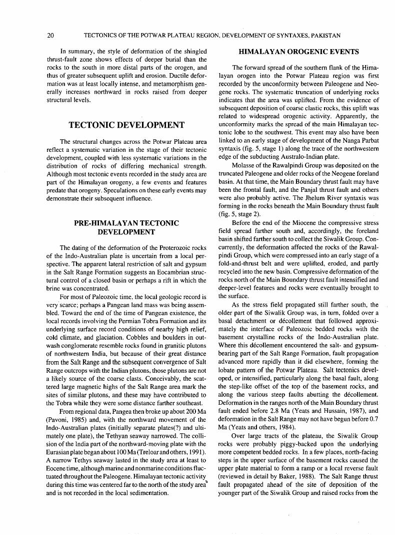
20 TECTONICS OF THE POTWAR PLATEAU REGION, DEVELOPMENT OF SYNTAXES, PAKISTAN
In summary, the style of deformation of the shingled thrust-fault zone shows effects of deeper burial than the rocks to the south in more distal parts of the orogen, and thus of greater subsequent uplift and erosion. Ductile defor mation was at least locally intense, and metamorphism gen erally increases northward in rocks raised from deeper structural levels.
TECTONIC DEVELOPMENT
The structural changes across the Potwar Plateau area reflect a systematic variation in the stage of their tectonic development, coupled with less systematic variations in the distribution of rocks of differing mechanical strength. Although most tectonic events recorded in the study area are part of the Himalayan orogeny, a few events and features predate that orogeny. Speculations on these early events may demonstrate their subsequent influence.
PRE-HIMALAYAN TECTONIC DEVELOPMENT
The dating of the deformation of the Proterozoic rocks of the Indo-Australian plate is uncertain from a local per spective. The apparent lateral restriction of salt and gypsum in the Salt Range Formation suggests an Eocambrian struc tural control of a closed basin or perhaps a rift in which the brine was concentrated.
For most of Paleozoic time, the local geologic record is very scarce; perhaps a Pangean land mass was being assem bled. Toward the end of the time of Pangean existence, the local records involving the Permian Tobra Formation and its underlying surface record conditions of nearby high relief, cold climate, and glaciation. Cobbles and boulders in out- wash conglomerate resemble rocks found in granitic plutons of northwestern India, but because of their great distance from the Salt Range and the subsequent convergence of Salt Range outcrops with the Indian plutons, those plutons are not a likely source of the coarse clasts. Conceivably, the scat tered large magnetic highs of the Salt Range area mark the sites of similar plutons, and these may have contributed to the Tobra while they were some distance farther southeast.
From regional data, Pangea then broke up about 200 Ma (Pavoni, 1985) and, with the northward movement of the Indo-Australian plates (initially separate plates(?) and ulti mately one plate), the Tethyan seaway narrowed. The colli sion of the India part of the northward-moving plate with the Eurasian plate began about 100 Ma (Treloar and others, 1991). A narrow Tethys seaway lasted in the study area at least to Eocene time, although marine and nonmarine conditions fluc tuated throughout the Paleogene. Himalayan tectonic activity during this time was centered far to the north of the study area and is not recorded in the local sedimentation.
HIMALAYAN OROGENIC EVENTS
The forward spread of the southern flank of the Hima layan orogen into the Potwar Plateau region was first recorded by the unconformity between Paleogene and Neo- gene rocks. The systematic truncation of underlying rocks indicates that the area was uplifted. From the evidence of subsequent deposition of coarse clastic rocks, this uplift was related to widespread orogenic activity. Apparently, the unconformity marks the spread of the main Himalayan tec tonic lobe to the southwest. This event may also have been linked to an early stage of development of the Nanga Parbat syntaxis (fig. 5, stage 1) along the trace of the northwestern edge of the subducting Australo-Indian plate.
Molasse of the Rawalpindi Group was deposited on the truncated Paleogene and older rocks of the Neogene foreland basin. At that time, the Main Boundary thrust fault may have been the frontal fault, and the Panjal thrust fault and others were also probably active. The Jhelum River syntaxis was forming in the rocks beneath the Main Boundary thrust fault (fig. 5, stage 2).
Before the end of the Miocene the compressive stress field spread farther south and, accordingly, the foreland basin shifted farther south to collect the Siwalik Group. Con currently, the deformation affected the rocks of the Rawal pindi Group, which were compressed into an early stage of a fold-and-thrust belt and were uplifted, eroded, and partly recycled into the new basin. Compressive deformation of the rocks north of the Main Boundary thrust fault intensified and deeper-level features and rocks were eventually brought to the surface.
As the stress field propagated still farther south, the older part of the Siwalik Group was, in turn, folded over a basal detachment or decollement that followed approxi mately the interface of Paleozoic bedded rocks with the basement crystalline rocks of the Indo-Australian plate. Where this decollement encountered the salt- and gypsum- bearing part of the Salt Range Formation, fault propagation advanced more rapidly than it did elsewhere, forming the lobate pattern of the Potwar Plateau. Salt tectonics devel oped, or intensified, particularly along the basal fault, along the step-like offset of the top of the basement rocks, and along the various steep faults abutting the decollement. Deformation in the ranges north of the Main Boundary thrust fault ended before 2.8 Ma (Yeats and Hussain, 1987), and deformation in the Salt Range may not have begun before 0.7 Ma (Yeats and others, 1984).
Over large tracts of the plateau, the Siwalik Group rocks were probably piggy-backed upon the underlying more competent bedded rocks. In a few places, north-facing steps in the upper surface of the basement rocks caused the upper plate material to form a ramp or a local reverse fault (reviewed in detail by Baker, 1988). The Salt Range thrust fault propagated ahead of the site of deposition of the younger part of the Siwalik Group and raised rocks from the
REFERENCES 21
lower part of the plate to a high position. Locally, at the east ern and western corners of the new frontal line, laterally unconfmed stress fields brought about some lateral thrust faulting, which produced the sigmoidal bend in structural features and topography at the eastern end of the Salt Range and the anomalously oriented folds at both ends of the range. Counterclockwise rotation of the plate also took place near the frontal line between about 9 and 0.7 Ma, in adjustment to the plates' wrapping around the west edge of the descending Indo-Australian plate. Younger blind thrust faulting may be developing beneath the anticline at Lilla.
At the same time, the Potwar Plateau region continued to be deformed by a combination of compressive stress (gen erally oriented north-northwest south-southeast), salt tec tonics, and uplift. Siwalik Group rocks were eroded, along with older rocks, and all were accumulated in the youngest depocenter of the Indo-Gangetic plains. The Main Boundary thrust plate did not cease its southward movement before 1.8 Ma (Yeats and Hussain, 1987). A right-lateral fault in the basement rock appears to have been reactivated. Pleistocene beds were locally tilted and faulted, and further uplift and erosion occurred across the entire study area. By this time, at least 16 km of cover was removed from the northern ranges (Opdyke and others, 1979) to reveal their greenschist and, locally, more intense grade of metamorphism. Near the center of the plateau, about 4 km of cover was removed and perhaps slightly more over the Salt Range. The Indus River syntaxis was growing (fig. 5, stage 3), and nearby thrust faulting took place as recently as 0.6 Ma (Khan, 1983).
Some reversal of faulting and possibly extensional tec- tonism occurs along the south side of the Peshawar basin and perhaps along the southeast flank of the Gandghar Mountains (fig. 3). This suggests that the internal or intramontane basin formed by extension, concurrently with compressive defor mation still in progress along the present frontal line. Such a diverse stress field probably reflects the presence of highly ductile conditions near the decollement beneath these areas.
The tectonic development continues. The frontal line may be expected to migrate forward as a new ramp is encountered by a decollement fault extension to the south- southeast, probably propagating along a weak horizon beneath the recent alluvial deposits and, as yet, unnoticed at the surface. Faults along the south side of the Peshawar basin are seismically active; the few normal faults along the foothills north of the Attock-Cherat Range, however, show the basin-ward block to be rising rather than settling, so the tectonic picture in that area is not fully clear.
REFERENCES
Acharyya, S.K., and Ray, K.K., 1982, Hydrocarbon possibilities of concealed Mesozoic-Paleogene sediments below Himalayan nappes Reappraisal: American Association of Petroleum Geologists Bulletin, v. 66, p. 57-70.
Baker, D.M., 1988, Balanced structural cross-sections of the central Salt Range and Potwar Plateau of Pakistan Shortening and overthrust deformation: Corvallis, Ore., Oregon State Univer sity, M.S. thesis, 120 p.
Baker, D.M., Lillie, R.J., Yeats, R.S., Johnson, G.D., Yousuf, M., and Zamin, A.S., 1988, Development of the Himalayan frontal thrust zone; Salt Range, Pakistan: Geological Society of America, Geology, v. 16, no. 1, p. 3-7.
Crawford, A.R., 1974, The Salt Range, the Kashmir syntaxis and the Pamir arc: Earth and Planetary Science Letters, v. 22, p. 371-379.
Crawford, A.R., and Davies, R.G., 1975, Ages of pre-Mesozoic of the Lesser Himalaya, Hazara district, northern Pakistan: Geo logical Magazine, v. 112, no. 5, p. 509-514.
Finetti, I., Georgetti, F., and Poretti, G., 1979, The Pakistani seg ment of the DDS profile, Nanga Parbat Kabul (1974-1975): Bolletino de Geofisica Teorica ed Applicata, v. 21, p. 159-171.
Gee, E.R., 1980, Pakistan Geological Salt Range series: Director ate of Overseas Surveys, United Kingdom, for the Government of Pakistan, and Geological Survey of Pakistan, 6 sheets, scale 1:50,000.
Jaume, S.C., and Lillie, R.J., 1988, Mechanics of the Salt Range- Potwar Plateau, Pakistan A fold-and-thrust belt underlain by evaporites: Tectonics, v. 7, no. 1, p. 57-71.
Johnson, G.D., Raynolds, R.G., and Burbank, D.W., 1986, Late Cenozoic tectonics and sedimentation in the northwestern Himalayan foredeep; I. Thrust ramping and associated defor mation in the Potwar region, in Alien, P., and Homewood, P., eds., Foreland basins: International Association of Sedimen- tologists Special Publication 8, p. 273-291.
Kazmi, A.H., and Rana, R.A., 1982, Tectonic map of Pakistan: Ministry of Petroleum and Natural Resources, Geological Sur vey of Pakistan, scale 1:2,000,000.
Khan, M.J., 1983, Magnetostratigraphy of Neogene and Quaternary Siwalik Group sediments of the Trans-Indus Salt Range, north western Pakistan: New York, Columbia University, Ph. D. dis sertation, 217 p.
Klootwijk, C.T., 1979, A summary of paleomagnetic data from peninsula Indopakistan and south central Asia: Implications for collisional tectonics, in Saklani, P.S., ed., Structural geolo gy of the Himalaya: Today and Tomorrow Printers and Pub lishers, New Delhi, p. 307-360.
Latif, M.A., 1974, A Cambrian age for the Abbotabad Group of Hazara, Pakistan: Punjab University Geological Bulletin, v. 10, p. 1-20.
Leathers, M.R., 1987, Balanced structural cross section of the west ern Salt Range and Potwar Plateau Deformation near the strike-slip terminus of an overthrust sheet: Corvallis, Ore., Oregon State University, M.S. thesis, 271 p.
Lefort, P., 1975, Himalayas The collided range. Present knowl edge of the continental arc: American Journal of Science, v. 275-A,p. 1-44.
Lillie, R.J., and Yousuf, M., 1986, Modern analogs for some mid- crustal reflections observed beneath collisional mountain belts, in Barazangi, M., and Brown, L., eds., Reflection seismolo gy The continental crust: American Geophysical Union Geodynamics Series, v. 14, p. 55-65.
Lillie, R.J., Johnson, G.D., Yousuf, M., Zamin, A.S., and Yeats, R.S., 1987, Structural development within the Himalayan fore land fold-and-thrust belt of Pakistan, in Beaumont, C., and
22 TECTONICS OF THE POTWAR PLATEAU REGION, DEVELOPMENT OF SYNTAXES, PAKISTAN
Tankard, A.J., eds., Basins of eastern Canada and worldwide analogs: Canadian Society of Petroleum Geologists Memoir 12, p. 379-392.
McDougall, J.W., and Hussain, Ahmad, 1991, Fold and thrust prop agation in the western Himalaya based on a balanced cross sec tion of the Surghar Range and Kohat Plateau, Pakistan: American Association of Petroleum Geologists Bulletin, v. 75, no. 3, p. 463^78.
McDougall, J.W., and Khan, S.H., 1990, Strike-slip faulting in a foreland fold-thrust belt The Kalabagh fault and western Salt Range, Pakistan: Tectonics, v. 19, no. 5, p. 1061-1075.
McKenzie, D.P., and Sclater, J.G., 1971, The evolution of the Indi an Ocean since the Late Cretaceous: Geophysical Journal, v. 25, p. 437-528.
Opdyke, N.D., Lindsay, E.H., Johnson, N.M., Tahirkheli, R.A., and Mirza, M.A., 1979, Magnetic polarity stratigraphy and verte brate paleontology of the Upper Siwalik subgroup of northern Pakistan: Paleogeology, Paleoclimatology, and Paleoecology, v. 27, p. 1-34.
Pavoni, N., 1985, Die Pazifische-antipazifische Bipolaritat im Structurbild der Erde und ihre geodynamische Deutung [The Pacific-antipacific bipolarity in the structural picture of the earth and its geodynamic significance]: Geologisches Rund schau, Bd. 74, H. 2, S. 251-266.
Pennock, E.S., 1988, Structural interpretation of seismic reflection data from the eastern Salt Range and Potwar Plateau, Pakistan: Corvallis, Ore., Oregon State University, M.S. thesis, 55 p.
Quittmeyer, R.C., and Jacob, K.H., 1979, Historical and modern seismicity of Pakistan, Afghanistan, northwestern India, and southeastern Iran: Bulletin of the Seismological Society of America, v. 69, p. 773-823.
Sarwar, G., and DeJong, K.A., 1979, Arcs, oroclines, syntaxes: The curvature of mountain belts in Pakistan, in Farah, A., and DeJong, K.A., eds., Geodynamics of Pakistan: Geological Survey of Pakistan, p. 341-349.
Seeber, L., Armbruster, J.G., and Quittmeyer, R.C, 1981, Seismic ity and continental subduction in the Himalayan arc, in Gupta, H.K., and Delany, P.M., eds., Zagros, Hindu Kush, Himalaya geodynamic evolution: American Geophysical Union, Geody namics Series 3, p. 215-242.
Seeber, L., and Jacob, K.H., 1977, Microearthquake survey of northern Pakistan, preliminary results and tectonic implica tions: Paris, France, CNRS Symposium of Geology and Ecol ogy of the Himalayas, Proceedings, p. 347-360.
Treloar, P.J., Potts, G.J., Wheeler, John, and Rex, D.C., 1991, Structural evolution and asymmetric uplift of the Nanga Parbat syntaxis, Pakistan Himalaya: Geologisches Rundschau, B. 80, H. 2, S. 411-428.
Voskresensky, I.A., 1965, Report on Area A 4, Potwar and the Punjab Plain: unpublished Pakistan Oil and Gas Development Corporation (OGDC) report, 85 p.
Waheed-ud-din, 1967, Report on gravity survey, Athar Uplift and Islamabad area, Western Province, Pakistan: unpublished Pakistan Oil and Gas Development Corporation (OGDC) report, 17 p., 7 maps.
1971, Report on gravity survey of western limits of Basal El L Bannu Plain Mianwali depression, Parhal area and regional gravity traverse in part of Kohat Potwar Foredeep, west of Indus River, Punjab and NWFP Provinces: unpublished Paki stan Oil and Gas Development Corporation (OGDC) report, 21 p., with tables and maps.
Waheed-ud-din, and Lotyshev, V.I., 1970, Report on gravity survey of Basal E/L area, District Campbellpur, West Pakistan: unpublished Pakistan Oil and Gas Development Corporation (OGDC) report, 23 p., 7 maps.
Yeats, R.S., and Hussain, Ahmad, 1987, Timing of structural events in the Himalayan foothills of northwestern Pakistan: Geologi cal Society of America Bulletin, v. 99, no. 8, p. 161-176.
Yeats, R.S., Kahn, S.H., and Akhtar, Mohammad, 1984, Late Qua ternary deformation of the Salt Range of Pakistan: Geological Society of America Bulletin, v. 95, no. 8, p. 958-966.
Published in the Central Region, Denver Colorado Manuscript approved for publication January 11, 1995 Edited by Craig Brunstein Graphics and Photocomposition by Mari L. Kauffmann
OU.S. GOVERNMENT PRINTING OFFICE: 1995-673-046/86124
SELECTED SERIES OF U.S. GEOLOGICAL SURVEY PUBLICATIONS
Periodicals
Earthquakes & Volcanoes (issued bimonthly). Preliminary Determination of Epicenters (issued monthly).
Technical Books and Reports
Professional Papers are mainly comprehensive scientific reports of wide and lasting interest and importance to professional scientists and engineers. Included are reports on the results of resource studies and of topographic, hydrologic, and geologic investigations. They also include collections of related papers addressing different aspects of a single sci entific topic.
Bulletins contain significant data and interpretations that are of lasting scientific interest but are generally more limited in scope or geo graphic coverage than Professional Papers. They include the results of resource studies and of geologic and topographic investigations; as well as collections of short papers related to a specific topic.
Water-Supply Papers are comprehensive reports that present sig nificant interpretive results of hydrologic investigations of wide interest to professional geologists, hydrologists, and engineers. The series covers investigations in all phases of hydrology, including hydrology, availabil ity of water, quality of water, and use of water.
Circulars present administrative information or important scientif ic information of wide popular interest in a format designed for distribu tion at no cost to the public. Information is usually of short-term interest.
Water-Resources Investigations Reports are papers of an inter pretive nature made available to the public outside the formal USGS pub lications series. Copies are reproduced on request unlike formal USGS publications, and they are also available for public inspection at deposi tories indicated in USGS catalogs.
Open-File Reports include unpublished manuscript reports, maps, and other material that are made available for public consultation at de positories. They are a nonpermanent form of publication that may be cit ed in other publications as sources of information.
Maps
Geologic Quadrangle Maps are multicolor geologic maps on to pographic bases in 7 1/2- or 15-minute quadrangle formats (scales main ly 1:24,000 or 1:62,500) showing bedrock, surficial, or engineering geology. Maps generally include brief texts; some maps include structure and columnar sections only.
Geophysical Investigations Maps are on topographic or planimet- ric bases at various scales, they show results of surveys using geophysi cal techniques, such as gravity, magnetic, seismic, or radioactivity, which reflect subsurface structures that are of economic or geologic signifi cance. Many maps include correlations with the geology.
Miscellaneous Investigations Series Maps are on planimetric or topographic bases of regular and irregular areas at various scales; they present a wide variety of format and subject matter. The series also in cludes 7 1/2-minute quadrangle photogeologic maps on planimetric bases which show geology as interpreted from aerial photographs. The series also includes maps of Mars and the Moon.
Coal Investigations Maps are geologic maps on topographic or planimetric bases at various scales showing bedrock or surficial geology, stratigraphy, and structural relations in certain coal-resource areas.
Oil and Gas Investigations Charts show stratigraphic informa tion for certain oil and gas fields and other areas having petroleum po tential.
Miscellaneous Field Studies Maps are multicolor or black-and- white maps on topographic or planimetric bases on quadrangle or irreg ular areas at various scales. Pre-1971 maps show bedrock geology in re lation to specific mining or mineral-deposit problems; post-1971 maps are primarily black-and-white maps on various subjects such as environ mental studies or wilderness mineral investigations.
Hydrologic Investigations Atlases are multicolored or black-and- white maps on topographic or planimetric bases presenting a wide range of geohydrologic data of both regular and irregular areas; the principal scale is 1:24,000, and regional studies are at 1:250,000 scale or smaller.
Catalogs
Permanent catalogs, as well as some others, giving comprehensive listings of U.S. Geological Survey publications are available under the conditions indicated below from USGS Map Distribution, Box 25286, Building 810, Denver Federal Center, Denver, CO 80225. (See latest Price and Availability List.)
"Publications of the Geological Survey, 1879-1961" may be pur chased by mail and over the counter in paperback book form and as a set microfiche.
"Publications of the Geological Survey, 1962-1970" may be pur chased by mail and over the counter in paperback book form and as a set of microfiche.
"Publications of the U.S. Geological Survey, 1971-1981" may be purchased by mail and over the counter in paperback book form (two volumes, publications listing and index) and as a set of microfiche.
Supplements for 1982, 1983, 1984, 1985, 1986, and for subse quent years since the last permanent catalog may be purchased by mail and over the counter in paperback book form.
State catalogs, "List of U.S. Geological Survey Geologic and Wa ter-Supply Reports and Maps For (State)," may be purchased by mail and over the counter in paperback booklet form only.
"Price and Availability List of U.S. Geological Survey Publica tions," issued annually, is available free of charge in paperback booklet form only.
Selected copies of a monthly catalog "New Publications of the U.S. Geological Survey" is available free of charge by mail or may be ob tained over the counter in paperback booklet form only. Those wishing a free subscription to the monthly catalog "New Publications of the U.S. Geological Survey" should write to the U.S. Geological Survey, 582 Na tional Center, Reston, VA 22092.
Note.-Prices of Government publications listed in older catalogs, announcements, and publications may be incorrect. Therefore, the prices charged may differ from the prices in catalogs, announcements, and pub lications.


