1 Norseman Gold Plc ARBN 122 088 073 Level 1, 33 Ord Street, West Perth Tel: (08) 9420 9300 Fax: (08) 9420 9399 ASX: NGX 10 August 2015 Norseman Gold Plc Company Operational and Exploration Update for the period 1 March 2015 to 30 June 2015 Norseman Gold Plc (Norseman or Company) remains suspended on the ASX. The Company sets out an operational and exploration update in relation to its principal operating subsidiary, Central Norseman Gold Corporation Pty Ltd (CNGC), for the four month period from 1 March 2015 to 30 June 2015. Highlights Exciting exploration results from RC drilling at Harlequin Mine area below the planned HV5 open pit: HARG01P - 8 metres at 25.2 grams per tonne gold from 72 metres downhole; HARG06P - 3 metres at 9.5 grams per tonne gold from 87 metres downhole; - 4 metres at 22.4 grams per tonne gold from 113 metres downhole; HARG11P - 9 metres at 11.3 grams per tonne gold from 66 metres downhole; HARG14P - 14 metres at 2.2 grams per tonne gold from 84 metres downhole; HARG16P - 10 metres at 2.3 grams per tonne gold from 65 metres downhole. Alluvial gold in two paleo-channels leading off the Princess Royal and North Royal Mines have been identified as high priority drilling targets. Increased faces identified to mine at Bullen Underground 23,637 ounces of fine gold produced and sold in the financial year Net EBITDA likely for financial year For personal use only
Transcript
1
Norseman Gold PlcARBN 122 088 073
Level 1, 33 Ord Street,West Perth
Tel: (08) 9420 9300Fax: (08) 9420 9399
ASX: NGX
10 August 2015
Norseman Gold Plc
Company Operational and Exploration Update for the period 1 March 2015 to 30 June 2015
Norseman Gold Plc (Norseman or Company) remains suspended on the ASX.
The Company sets out an operational and exploration update in relation to its principal operating
subsidiary, Central Norseman Gold Corporation Pty Ltd (CNGC), for the four month period from 1
March 2015 to 30 June 2015.
Highlights
Exciting exploration results from RC drilling at Harlequin Mine area below the planned HV5open pit:HARG01P - 8 metres at 25.2 grams per tonne gold from 72 metres downhole;HARG06P - 3 metres at 9.5 grams per tonne gold from 87 metres downhole;
- 4 metres at 22.4 grams per tonne gold from 113 metres downhole;HARG11P - 9 metres at 11.3 grams per tonne gold from 66 metres downhole;HARG14P - 14 metres at 2.2 grams per tonne gold from 84 metres downhole;HARG16P - 10 metres at 2.3 grams per tonne gold from 65 metres downhole.
Alluvial gold in two paleo-channels leading off the Princess Royal and North Royal Mineshave been identified as high priority drilling targets.
Increased faces identified to mine at Bullen Underground
23,637 ounces of fine gold produced and sold in the financial year
Net EBITDA likely for financial year
For
per
sona
l use
onl
y
2
OPERATIONS SUMMARY
Current Mining
During the period, the Company has continued remnant mining and has commenced some
operations as identified in the resource development review undertaken in the previous period. In
summary:
Harlequin
Remnant open pit mining has continued on the pit floor of HV1 to remove the remaining recoverable
section of the crown pillar.
Further, the success of the drilling at the south west end of the HV1 pit and along the HV11 strike as
previously referred to has seen mining occur in the south west wall of the pit. In order to access the
ore in the south west cut back considerable waste had to be removed.
In the period a total of 12,439 tonnes of
ore was mined at the HV1 pit.
Unless any further extensions at
Harlequin are uncovered it is expected
that remnant mining in the existing
Harlequin pit will conclude by middle to
late August 2015.
Figure. 1: HV1 Pit – South West Cut Back
North Royal
The open cut mining of remnant pillars in Pit D was completed in August 2014. An internal study
recommended the mining of the remnant underground pillars in the northern section of Pit E by
open cut. These pillars are located in the 195RL to 170 RL section of Pit E. Mining at Pit E commenced
in early June 2015 and is expected to be completed in September 2015. In June CNGC mined 28
tonnes of ore at North Royal.
For
per
sona
l use
onl
y
3
Figure 2. North Royal Pit E – Pillar extraction
Bullen Underground
During the period, 4,174 tonnes of ore was mined underground at Bullen and hauled to the surface.
CNGC senior management also undertook an extensive review of the Bullen underground operations
to maximise productivity and grade. During this review underground mining was suspended for a
time to enable this comprehensive review to be completed. As a consequence, a number of
additional headings have been identified focussing on 4 reefs; the 2 Mararoa reefs and the St Pats
No. 1 and St Pats No. 2 reefs. CNGC has recently recommenced its mining operations at Bullen and is
in the process of ramping up its operations. From a mining perspective, CNGC has implemented a
new mining method which focuses on in-lode development on ore with the development faces all
shanty backed profiled to suit the dip of the hanging wall and to minimise overbreak. This ensures
minimal ground control problems. The Company is expecting that the Bullen mine will be a major
provider of high grade ore over the next 6 months.
Low Grade Trials
The trials of the low grade waste dumps at Daisy, Bullen waste dump and North Royal waste dumps
have continued over the past 4 months. In addition, the trials have been extended to include the
Scotia dump. The outcomes of these trials have been inconclusive and a full analysis of the
metallurgical reconciliations is being undertaken to determine grade recovery of these trials. CNGC
has also been evaluating processes to remove clay from some of the North Royal processed ore
stockpiles to provide potential additional recoveries.
Further, preliminary work has commenced on investigating new technologies to remove sulphide
from the Red White and Blue stockpiled ore and the other sulphide deposits along the Noganyer
sedimentary iron formation (SIF).
For
per
sona
l use
onl
y
4
A trial has also been undertaken with Tomra at Castle Hill, Sydney in relation to ore sorting
capabilities to upgrade some of the low grade dumps through the separation of the gold bearing ore
from the waste. No decision has been made as to whether or not to proceed with a more extensive
trial on site.
Production Results
In the relevant period, 7,716 ounces of fine gold were produced and sold for $11,421,512.04 net
revenue (i.e. after Royalties and swap fees) at an average price of A$1,480.23 per ounce.
For the financial year 1 July 2014 to 30 June 2015 a total of 23,637 ounces of fine gold were
produced and sold for $32,911,112 net revenue (i.e. after Royalties and swap fees) at an average
price of A$1,392.32 per ounce.
The operations remain un-hedged.
Financials
CNGC is in the process of finalising its year end results. The company expects to report a net EBITDA
for the year excluding interest expenses which have been accrued but not paid.
The Company is in breach of various covenants under its financing arrangements with the Tulla
Group and related entities and the Company and its subsidiaries remain subject to the ongoing
support of its major shareholder and secured lender, Tulla Resources Group Pty Ltd and related
entities.
Near Mine Potential
Crown Reef
In relation to the geotechnical review and internal scoping of the Crown Reef Pillars Project reported
in the previous update, that study has been put on hold due to the development costs that the study
determined would be required to safely assess the Crown Reef.
Butterfly
A PMP has been submitted to the Department of Mines & Petroleum for a Stage I open pit. The next
step is to prepare and submit a Mining Proposal.
HV5B
An initial pit optimisation was prepared for a new open pit at Harlequin and an infill drilling program
was prepared, which is currently underway (and is referred to in more detail in the Exploration
Section. Once the results of the current drilling program have been analysed the HV5B pit will be
remodelled and reoptimised.
Maybell
The economics of this ore body has been reviewed and an infill drilling program has been designed.
The outcome of the drilling program will determine the next steps in evaluating this deposit. The
deposit will then be remodelled and reoptimised prior to a mining proposal submission.
For
per
sona
l use
onl
y
5
Cobbler
A pit optimisation has been reviewed and further work has been undertaken to evaluate this deposit.
A Native Title review is also underway.
Northern Star
Following the costeaning and trial bulk sampling which was undertaken a drilling campaign will
follow up on the initial tests. This campaign has been designed and it is currently anticipated to
commence following the drilling at HV5B.
Other Projects
The assessment of the viability of the gypsum and iron ore deposits has continued.
The gypsum deposits are principally located on mining leases at Daisy and Harlequin and on
exploration tenements on the edge of Lake Cowan (WSW from the township of Norseman).
The Company is planning a systematic mapping and assaying program, which may lead to shallow
drilling to identify resource areas to be mined and trial shipped to market. The Company has
employed a specialist gypsum senior geologist to oversee this program.
In relation to the iron ore, the gold potential in the banded irons (BIF) on the Noganyer formation
and sedimentary iron formations (SIF) are being further evaluated and assessed.
Plant and Processing
As foreshadowed, further maintenance and significant capital works were expended on the Phoenix
Mill during the period. This work enabled the Plant to ramp up to 24 hour continuous production;
initially on a Sunday evening to Friday afternoon roster.
For the 4 months from 1 March 2015 to 30 June 2015, the mill processed a total of 102,359 dry
tonnes of ore at an average head grade of 2.95 grams per tonne at a recovery rate of 93.9%.
EXPLORATION SUMMARY
(1) RC Drilling Results at HV5 within the Harlequin Gold Complex
Introduction
The Harlequin gold complex has to date produced about 750,000 ounces at 9 grams per tonne from
a number of quartz reefs hosted in gabbro and granodiorite rock units.
The highest grades tend to be located within dilational sites where primary structures have diffracted
through more competent host units, and it is found that the main producing reefs tend to occur
within two south plunging mineralised shoot complexes.
The Eastern ore corridor has previously been mined from underground and open cut, and near
surface ore is currently being mined by deepening and extending the HV1 Open Pit (see above).
For
per
sona
l use
onl
y
6
The Western ore corridor has previously been mined from underground and ‘Whittle Open Pit
Optimisation Studies’ suggest that it may be profitable to mine the near surface ore from the
‘Planned HV5 Pit’. Further drilling has been completed, with more holes in progress, in order to
increase the reserve which will hopefully optimise as a deeper open cut.
RC drilling (Intersections are not reported as true widths)
The information reported below is for eighteen RC holes for a total of 2,073 metres, which were
designed to test outside the ‘Planned HV5 Pit Shell’ with the possibility of eventually mining deeper
than what is currently planned.
Some of the intersections tabled below are very high grade and follow up-drilling is underway.
(See Table 1 and Figures 3 to 5)
Figure 3: HV5 - Collar Plan including all underground and surface holes - July 2015
Figure 4: Harlequin HV5 Interpreted cross-section at 6,446,180 North
Figure 5: Harlequin HV5 Interpreted cross-section at 6,446,140 North
For
per
sona
l use
onl
y
9
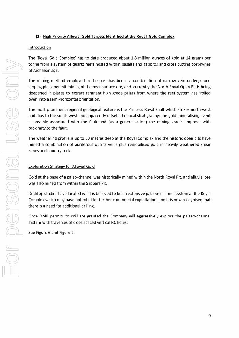
(2) High Priority Alluvial Gold Targets Identified at the Royal Gold Complex
Introduction
The ‘Royal Gold Complex’ has to date produced about 1.8 million ounces of gold at 14 grams per
tonne from a system of quartz reefs hosted within basalts and gabbros and cross cutting porphyries
of Archaean age.
The mining method employed in the past has been a combination of narrow vein underground
stoping plus open pit mining of the near surface ore, and currently the North Royal Open Pit is being
deepened in places to extract remnant high grade pillars from where the reef system has ‘rolled
over’ into a semi-horizontal orientation.
The most prominent regional geological feature is the Princess Royal Fault which strikes north-west
and dips to the south-west and apparently offsets the local stratigraphy; the gold mineralising event
is possibly associated with the fault and (as a generalisation) the mining grades improve with
proximity to the fault.
The weathering profile is up to 50 metres deep at the Royal Complex and the historic open pits have
mined a combination of auriferous quartz veins plus remobilised gold in heavily weathered shear
zones and country rock.
Exploration Strategy for Alluvial Gold
Gold at the base of a paleo-channel was historically mined within the North Royal Pit, and alluvial ore
was also mined from within the Slippers Pit.
Desktop studies have located what is believed to be an extensive palaeo- channel system at the Royal
Complex which may have potential for further commercial exploitation, and it is now recognised that
there is a need for additional drilling.
Once DMP permits to drill are granted the Company will aggressively explore the palaeo-channel
system with traverses of close spaced vertical RC holes.
See Figure 6 and Figure 7.
For
per
sona
l use
onl
y
10
Figure 6: Royal Complex – Interpreted alluvial channels, drill hole collars, open pits, waste dumps and Princess RoyalFault.
For
per
sona
l use
onl
y
11
Figure 7: Slippers Pit - interpreted drilling cross section at 6,444,170 North showing gold at the base of an alluvialchannel.
(3) Lake Dundas Gypsum Project
Introduction
The Norseman Field is one of the oldest producers of gold in Australia and there is definitely a strong
future in gold for the Company, but in addition there is potential for other commodities including
gypsum, nickel, copper and magnetite iron ore.
The Company believes it is well located with regard to tenure and infrastructure and is actively
looking for new opportunities.
In terms of gypsum potential, the Company’s Lake Cowan tenements host ‘evaporite’ style gypsum
(CaS04.2H2O) deposits in the form of wind-blown dunes and gypsum banks which are on granted
mining tenements.
In addition, the Company has recognised the world class gypsum potential at Lake Dundas and two
‘Exploration Licence Applications’ have recently been lodged with the West Australian ‘Department
of Minerals and Petroleum’ and the Company is planning to explore this area as soon as the
tenements are granted.
For
per
sona
l use
onl
y
12
Figure 8: Lake Dundas Gypsum Project Area with exploration licence applications and existing transport infrastructure.
Uses of Gypsum
Large quantities of gypsum are consumed on a global basis and some of the common usages of
gypsum include:
As an agricultural additive for crop improvement.
As an ingredient in cement manufacture.
As an essential component in the manufacture of many plaster board and building product
materials.
A strategy in relation to the gypsum potential is in progress. The gypsum deposits are conveniently
located on rail and road hubs with excellent access to Esperance, which is an export port with bulk
handling facilities.
As part of this strategy, the Company has commenced a ‘soft’ marketing campaign and there is a
degree of interest being shown by both national and international end users of gypsum.
Tenements
CNGC entered into a Tenement Swap Agreement with Mt Henry Gold Pty Ltd (a wholly owned
subsidiary of Panoramic Resources Ltd) and Australian Strategic and Precious Metals Investment Pty
Ltd (a wholly owned subsidiary of Masta Resources Ltd) whereby CNGC transferred P63/1890 in
consideration for 3 tenements; P63/1391; P63/1392 & P63/1393.
During the period 2 tenements expired – E63/1293 & P63/1851.
For
per
sona
l use
onl
y
13
Corporate
The Company’s Annual Report 2014 was released on 8 April 2015.
On 18 May 2015 the Company announced the untimely passing of John Watkins, the resident
General Manager of CNGC. The Company recognises John’s contribution in the short time he was
General Manager and expresses its condolences to his family and many friends in the industry and
personal.
Competent Persons Statement
The information in this report which relates to Exploration Results is based on information compiled
by Mr Ernest Poole, an employee of Central Norseman Gold Corporation Pty Ltd and a Member of the
Australian Institute of Geoscientists. Mr Poole has sufficient experience which is relevant to the style
of mineralisation and type of deposit under consideration and to the activity which he is undertaking
to qualify as a Competent Person as defined in the 2012 Edition of the ‘Australasian Code for
reporting of Exploration Results, Mineral Resources and Ore Reserves’ (The JORC Code). Mr Poole
consents to the inclusion in this announcement of the statements based on this information in the
form and context in which it appears. Exploration results are based on standard industry practices,
including sampling, assay methods, and appropriate quality assurance quality control (QAQC)
measures. Reverse circulation (RC) samples are collected as 1 meter samples. Core samples are taken
as half NQ core or quarter HQ core and sampled to geological boundaries where appropriate. The
quality of RC drilling samples is optimised by the use of riffle and/or cone splitters, dust collectors, and
use of field duplicates to measure sample representivity. For soil samples, PGM and gold assays are
based on an Aqua Regia digest with Induced Coupled Plasma (ICP) finish and base metal assays may
be based on Aqua Regia or Four Acid Digest with Inductively Coupled Plasma Optical Emission
spectrometry (ICPOES) or Atomic Absorption Spectrometry (AAS) finish. Sample preparation and
analysis is undertaken at Bureau Veritas laboratories in Perth and Kalgoorlie, Western Australia. The
quality of analytical results is monitored by the use of internal laboratory procedures and standards
together with certified standards, duplicates and blanks and statistical analysis where appropriate to
ensure that results are representative and within acceptable ranges of accuracy and precision.
Intersections are length and density weighted where appropriate as per standard industry practice.
All sample and drill hole co-ordinates are based on the GDA/MGA grid and datum unless otherwise
stated. Exploration results obtained by Sirius have not necessarily been obtained using the same
methods or subjected to the same QAQC protocols. These results may not have been independently
verified because original samples and/or data may no longer be available.
For
per
sona
l use
onl
y
14
Appendix
Figure 7: Norseman Gold Plc Exploration projects reported in the June 2015 Quarter.
For
per
sona
l use
onl
y
15
The following Tables are provided to ensure compliance with the JORC Code (2012) edition requirements for the reporting of exploration results.
JORC Code, 2012 Edition – Table 1 report template
Section 1 Sampling Techniques and Data
(Criteria in this section apply to all succeeding sections.)
Criteria JORC Code explanation Commentary
Sampling
techniques
Nature and quality of sampling (eg cut channels, randomchips, or specific specialised industry standard measurementtools appropriate to the minerals under investigation, such asdown hole gamma sondes, or handheld XRF instruments,etc). These examples should not be taken as limiting thebroad meaning of sampling.
Include reference to measures taken to ensure samplerepresentivity and the appropriate calibration of anymeasurement tools or systems used.
Aspects of the determination of mineralisation that areMaterial to the Public Report. In cases where ‘industrystandard’ work has been done this would be relatively simple(eg ‘reverse circulation drilling was used to obtain 1 msamples from which 3 kg was pulverised to produce a 30 gcharge for fire assay’). In other cases more explanation maybe required, such as where there is coarse gold that hasinherent sampling problems. Unusual commodities ormineralisation types (eg submarine nodules) may warrantdisclosure of detailed information.
The HV5 prospect has been sampled by vertical and angled RC drilling
on an irregular pattern of 18 infill holes.
Sampling was carried out under CNGC protocols and QAQC
procedures as per industry best practice.
RC drilling was sampled every one metre downhole using a ‘cone’
splitter to produce a bulk 3 kg sample.
Samples were crushed, dried and pulverised (total prep) to produce a
50 g charge for fire assay (gold exploration)
Drilling
techniques
Drill type (eg core, reverse circulation, open-hole hammer,rotary air blast, auger, Bangka, sonic, etc) and details (egcore diameter, triple or standard tube, depth of diamond tails,face-sampling bit or other type, whether core is oriented andif so, by what method, etc).
Reverse circulation (RC) drilling was conducted at HV5 Prospect.
For
per
sona
l use
onl
y
16
Criteria JORC Code explanation Commentary
Drill sample
recovery
Method of recording and assessing core and chip samplerecoveries and results assessed.
Measures taken to maximise sample recovery and ensurerepresentative nature of the samples.
Whether a relationship exists between sample recovery andgrade and whether sample bias may have occurred due topreferential loss/gain of fine/coarse material.
No method is employed to measure RC chip sample recovery, but wet
areas or areas of lesser sample recovery are noted in the logging.
Overall recoveries are good and there are no significant sample
recovery problems.
The RC drill has sufficient air volume and pressure to ensure that a ‘dry
face’ is being drilled and the samples are not excessively wet.
Drill cyclone is cleaned between rod changes in wet ground and after
each hole is completed to minimise downhole and/or cross hole
contamination.
Every 1 metre interval of cuttings is collected in a separate clean plastic
bag and stored temporarily at the drill site for future resampling checks
RC drilling samples were occasionally wet which may have resulted in
sample bias due to preferential loss/gain of fine/coarse material. This
typically occurred in the barren Quaternary lake sediments, and not in
oxidised or fresh basement rocks. No known studies have been
completed in recent years to determine a relationship between sample
recovery and grade
Logging Whether core and chip samples have been geologically andgeotechnically logged to a level of detail to supportappropriate Mineral Resource estimation, mining studies andmetallurgical studies.
Whether logging is qualitative or quantitative in nature. Core(or costean, channel, etc) photography.
The total length and percentage of the relevant intersectionslogged.
Logging of RC records lithology, mineralogy, mineralisation, veining,
alteration, weathering, colour and other features of the sample.
No photographs were taken of the RC cuttings, but a sample from each
metre downhole is collected in a ‘chip tray’ and stored in a locked shed.
All drill holes were logged in full.
Sub-sampling
techniques
and sample
preparation
If core, whether cut or sawn and whether quarter, half or allcore taken.
If non-core, whether riffled, tube sampled, rotary split, etcand whether sampled wet or dry.
For all sample types, the nature, quality and appropriatenessof the sample preparation technique.
Quality control procedures adopted for all sub-samplingstages to maximise representivity of samples.
Measures taken to ensure that the sampling is representative
No core drilling was carried out as part of this program.
1 metre RC samples were collected via an on-board cone splitter.
Samples were collected both wet and dry.
The sample sizes and number of field duplicates for (potentially)
nuggetty-Au intersections is considered to be appropriate to
appropriately represent the targeted mineralisation style.
The sample preparation follows industry best practice in sample
preparation. All samples were pulverised using Essa LM1, LM2, LM3 or
For
per
sona
l use
onl
y
17
Criteria JORC Code explanation Commentary
of the in situ material collected, including for instance resultsfor field duplicate/second-half sampling.
Whether sample sizes are appropriate to the grain size of thematerial being sampled.
LM5 grinding mills determined by the size of the sample. Samples are
dried, crushed as required and pulverised to produce a homogenous
representative sub sample for analysis. A grind quality target of 85%
passing 75 microns has been established and is relative to sample size,
type and hardness.
Certified Reference Materials (CRM’s) and in-house controls, blanks,
splits and replicates are analysed with each batch of samples. These
quality control results are reported along with the sample values in the
final lab report. Selected samples are also re-assayed to confirm
anomalous results.
Regular field duplicates and /or CRM’s are inserted every 25 metres.
Quality of
assay data
and laboratory
tests
The nature, quality and appropriateness of the assaying andlaboratory procedures used and whether the technique isconsidered partial or total.
For geophysical tools, spectrometers, handheld XRFinstruments, etc, the parameters used in determining theanalysis including instrument make and model, readingtimes, calibrations factors applied and their derivation, etc.
Nature of quality control procedures adopted (eg standards,blanks, duplicates, external laboratory checks) and whetheracceptable levels of accuracy (ie lack of bias) and precisionhave been established.
The analytical technique used a 50 gram charge with fire assay withAAS finish which gives total digestion.
No geophysical tools were used to determine any elementconcentrations used in this report or in any resource model.
Sample preparation checks for fineness were carried out by thelaboratory as part of their internal procedures to ensure the grind size of85% passing 75 micron was being attained. Laboratory QAQC involvesthe use of internal lab standards using certified reference material,blanks, splits and replicates as part of the in-house procedures.
Verification of
sampling and
assaying
The verification of significant intersections by eitherindependent or alternative company personnel.
The use of twinned holes. Documentation of primary data, data entry procedures, data
verification, data storage (physical and electronic) protocols. Discuss any adjustment to assay data.
CNGC’s Senior Geologist on site has visually verified significantintersections in samples from all prospects reported.
No twin holes were drilled to date. Primary data was collected using a set of standard Excel templates
using look up codes. The information was validated and compiled into aSQL database on site.
No adjustments or calibrations were made to any assay data reporting.
Location of
data points
Accuracy and quality of surveys used to locate drill holes(collar and down-hole surveys), trenches, mine workings andother locations used in Mineral Resource estimation.
Specification of the grid system used.
Drillhole collars were located by DGPS. Elevation values were in AHD.Expected accuracy is +/- 0.05m for elevation co-ordinates with DGPS.
The grid system used was MGA94 (Zone 51) with local easting andnorthing in MGA and elevation values in AHD RL. All tabulated,quantitative data is reported in MGA94.
Topographic control is sourced from published government survey datato calibrate the Leica base station to known survey points. Additional
For
per
sona
l use
onl
y
18
Criteria JORC Code explanation Commentary
Quality and adequacy of topographic control.
topographic control uses CNGC’s regional aerial photography flown on29/3/1982 and photogrametrically compiled by Aerial Surveys ofAustralia in September 1983 into 1:7,500 base sheets at 5m contourintervals.
Data spacing
and
distribution
Data spacing for reporting of Exploration Results. Whether the data spacing and distribution is sufficient to
establish the degree of geological and grade continuityappropriate for the Mineral Resource and Ore Reserveestimation procedure(s) and classifications applied.
Whether sample compositing has been applied.
The nominal sample spacing is 1m and line spacing in the order of 20-100m, dependant on the location of pre-existing drilling.
The mineralised domains have demonstrated sufficient continuity in bothgeological and grade continuity to support the definition of MineralResource and Reserves by the classification applied under the 2012JORC Code.
No sample compositing has been applied to the exploration results.
Orientation of
data in
relation to
geological
structure
Whether the orientation of sampling achieves unbiasedsampling of possible structures and the extent to which thisis known, considering the deposit type.
If the relationship between the drilling orientation and theorientation of key mineralised structures is considered tohave introduced a sampling bias, this should be assessedand reported if material.
No orientation based sampling bias has been identified in the data atthis point.
No variable orientation of the Harlequin Reef Complex is such that it isnot possible to report all intersections as true widths and hence thereporting states that ‘intersections are not reported as true widths’.
Sample
security
The measures taken to ensure sample security. Chain of custody is managed by CNGC. Samples are stored on site andcollected by Pat Hogan Transport and delivered direct to the assaylaboratory. Whilst in storage they are kept in a locked yard. Trackingsheets have been set up to track the progress of batches of samples.
Audits or
reviews
The results of any audits or reviews of sampling techniquesand data.
No exhaustive audit of the data has been carried out, but the on-siteDatabase Manager has performed QAQC checks on incoming data priorto loading into the database.
Section 2 Reporting of Exploration Results
(Criteria listed in the preceding section also apply to this section.)
Criteria JORC Code explanation Commentary
Mineral
tenement and
land tenure
Type, reference name/number, location and ownershipincluding agreements or material issues with third partiessuch as joint ventures, partnerships, overriding royalties,native title interests, historical sites, wilderness or nationalpark and environmental settings.
Harlequin Project is on mining tenement M63/48.Registered holder
Central Norseman Gold Corporation Pty Ltd Registered Mortgage
387124: STEINEPREIS, David Christian 96/96 shares CENTRAL
NORSEMAN GOLD CORPORATION LTD (now known as Central
For
per
sona
l use
onl
y
19
Criteria JORC Code explanation Commentary
status The security of the tenure held at the time of reporting alongwith any known impediments to obtaining a licence tooperate in the area.
Tulla Resources Group Pty Ltd ( mortgaged Shares 100/100 shares
CENTRAL NORSEMAN GOLD CORPORATION LTD (now known as
Central Norseman Gold Corporation Pty Ltd)
All CNGC tenements are within the Ngadju Native Title Claim
(WC99/002)
The tenements are in good standing and no known impediments exist.
Exploration
done by other
parties
Acknowledgment and appraisal of exploration by otherparties.
Multiple phases of work have been completed in the main field and
surrounding areas including mining for more than 120 years. Numerous
underground workings exist as well as many drill holes. Shafts and other
openings are present from surface. Numerous phases of geological
mapping and interpretation of the reefs have been completed.
Geology Deposit type, geological setting and style of mineralisation. The Norseman area lies at the southern extent of the Norseman-Wiluna
Greenstone Belt of the Eastern Goldfields Province of the Yilgarn Block,
Western Australia. The Archaean aged rocks overall become younger
towards the west but folding and faulting, including thrusting with
repetition of strata resulting in near vertical stratigraphy complicates the
sequence.
The reefs tested are hosted by the Woolyeenyer Formation which
unconformably overly the older Noganyer and Penneshaw Formations.
The Woolyeenyer consists dominantly of a sequence of basaltic pillow
lavas, with minor interflow sediments and a series of intrusive gabbro to
ultramafic dykes and sills. Felsic porphyry dykes have extensively
For
per
sona
l use
onl
y
20
Criteria JORC Code explanation Commentary
intruded the sequence.
The Norseman style of gold mineralisation applicable to the veins tested
consist of hydrothermally emplaced quartz veins of Si–Au +/-Cu-+/-Zn
+/- Pb with pressure release resulting in the material separating from
hydrothermal fluids. Veins tend to be thicker and higher grade in coarse
grained mafic rocks. Gabbro sills and dykes; glomeroporphyritic basalts
(Blue Bird Gabbro) and granodiorite are the main hosts for the
laminated Au bearing quartz veins in the main field.
The Jimberlana Dyke and other Proterozoic aged dominantly doleritic
dykes are intruded into the older stratigraphy: The Jimberlana Dyke is a
cumulate, layered, funnel shaped dolerite dyke up to 2km wide which
trends approximately E-W transecting the Norseman greenstone belt.
Costeans have the potential to expose dolerite dykes to the south of the
Jimberlana Dyke.
The regional metamorphic grade in the Norseman Greenstone Belt
varies from greenschist facies in the central field to middle amphibolite
facies to the south around the Scotia mine where the greenstone
sequence is highly attenuated between granite. In the area of
costeaning the rocks are greenschist facies.
Only narrow alteration haloes are associated with the gold deposits at
Norseman implying that the deposits formed during deformation at high
temperatures and pressures at depth and probably near peak
metamorphism.
Drill hole
Information
A summary of all information material to the understanding ofthe exploration results including a tabulation of the followinginformation for all Material drill holes:o easting and northing of the drill hole collaro elevation or RL (Reduced Level – elevation above sea
level in metres) of the drill hole collaro dip and azimuth of the holeo down hole length and interception deptho hole length.
If the exclusion of this information is justified on the basis
Refer to Tables in body of text. Exclusion of vital information is not a factor.
For
per
sona
l use
onl
y
21
Criteria JORC Code explanation Commentary
that the information is not Material and this exclusion doesnot detract from the understanding of the report, theCompetent Person should clearly explain why this is thecase.
Data
aggregation
methods
In reporting Exploration Results, weighting averagingtechniques, maximum and/or minimum grade truncations (egcutting of high grades) and cut-off grades are usuallyMaterial and should be stated.
Where aggregate intercepts incorporate short lengths of highgrade results and longer lengths of low grade results, theprocedure used for such aggregation should be stated andsome typical examples of such aggregations should beshown in detail.
The assumptions used for any reporting of metal equivalentvalues should be clearly no metal equivalent values are usedfor reporting exploration results should be stated.
All reported intersections have been length weighted. No top-cuts havebeen applied.
A nominal 0.5 g/t lower cut-off is used for the RC intersections. High grade gold and base metal interval to broader zones of
mineralisation are reported as included intervals. No metal equivalent values were used for reporting exploration results.
Relationship
between
mineralisation
widths and
intercept
lengths
These relationships are particularly important in the reportingof Exploration Results.
If the geometry of the mineralisation with respect to the drillhole angle is known, its nature should be reported.
If it is not known and only the down hole lengths arereported, there should be a clear statement to this effect (eg‘down hole length, true width not known’).
The Harlequin quartz veins are on a variety of different orientationswhich makes interpretation complicated, but there is a database of welldocumented geology from both underground mining and historic drilling(both surface and underground). The new holes reported in the body ofthis report add to an already large database and the geologicalinterpretations are made with a reasonably high degree of geologicalconfidence.
Diagrams Appropriate maps and sections (with scales) and tabulationsof intercepts should be included for any significant discoverybeing reported These should include, but not be limited to aplan view of drill hole collar locations and appropriatesectional views.
Refer to Figures in body of text.
Balanced
reporting
Where comprehensive reporting of all Exploration Results isnot practicable, representative reporting of both low and highgrades and/or widths should be practiced to avoid misleadingreporting of Exploration Results.
All sampled intersections for the drilling programme have been reported.
Other
substantive
exploration
Other exploration data, if meaningful and material, should bereported including (but not limited to): geologicalobservations; geophysical survey results; geochemicalsurvey results; bulk samples – size and method of treatment;
Refer to body of text.For
per
sona
l use
onl
y
22
Criteria JORC Code explanation Commentary
data metallurgical test results; bulk density, groundwater,geotechnical and rock characteristics; potential deleterious orcontaminating substances.
Further work The nature and scale of planned further work (eg tests forlateral extensions or depth extensions or large-scale step-outdrilling).
Diagrams clearly highlighting the areas of possibleextensions, including the main geological interpretations andfuture drilling areas, provided this information is notcommercially sensitive.
At this stage mineralisation is only indicative and requires further infill totest for coherency.Refer to Figures in body of text.