Sessione 2.2: Effetti di sito e microzonazione sismica ADVANTAGES OF INTEGRATING PHOTO-GEOLOGY AND FIELD- BASED GEOLOGICAL MAPPING. AN EXAMPLE FROM POST-SEISMIC ACTIVITIES IN AMATRICE (CENTRAL ITALY). TEMA 2: CARATTERIZZAZIONE SISMICA DEL TERRITORIO Cardinali M., Santangelo M., Mancini M., Moscatelli M., Vignaroli G., Working group CNR IRPI and IGAG
Transcript
Sessione 2.2: Effetti di sito e microzonazione sismica
ADVANTAGES OF INTEGRATING PHOTO-GEOLOGY AND FIELD-
BASED GEOLOGICAL MAPPING.
AN EXAMPLE FROM POST-SEISMIC ACTIVITIES IN AMATRICE
(CENTRAL ITALY).
TEMA 2: CARATTERIZZAZIONE SISMICA DEL TERRITORIO
Cardinali M., Santangelo M., Mancini M., Moscatelli M.,
Vignaroli G., Working group CNR IRPI and IGAG
After the 24 August 2016 earthquake, Seismic
Microzonation Studies were planned and initiated in
order to provide the basis for reconstruction of the
most damaged villages comprising the Amatrice area
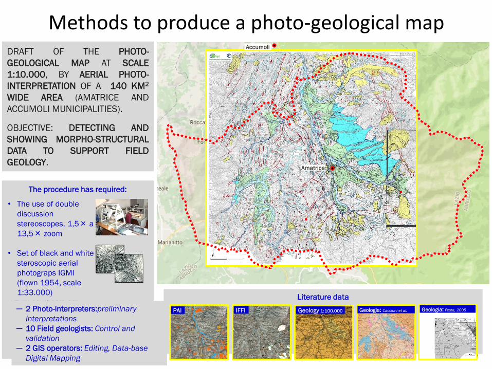
IFFIPAI Geology 1:100.000 Geologia: Cacciuni et al. Geologia: Festa, 2005
DRAFT OF THE PHOTO-
GEOLOGICAL MAP AT SCALE
1:10.000, BY AERIAL PHOTO-
INTERPRETATION OF A 140 KM2
WIDE AREA (AMATRICE AND
ACCUMOLI MUNICIPALITIES).
OBJECTIVE: DETECTING AND
SHOWING MORPHO-STRUCTURAL
DATA TO SUPPORT FIELD
GEOLOGY.
The procedure has required:
•TEAM composto da:
• The use of double
discussion
stereoscopes, 1,5× a
13,5× zoom
• Set of black and white
steroscopic aerial
photograps IGMI
(flown 1954, scale
1:33.000)
─ 2 Photo-interpreters:preliminary
interpretations
─ 10 Field geologists: Control and
validation
─ 2 GIS operators: Editing, Data-base
Digital Mapping
Amatrice
Accumoli
Methods to produce a photo-geological map
4
Landslide
Trench
Tabular surface (t)and scarps
Alluvia
Adjoining Alluvial Fans
Fault
Facet (escarpment)
be
dd
ing
Bedding trace
gently dippingmoderate
elevate
Upside down
Uncertain b. trace
Morphological elements and Covers
Structural Elements
Photo-geological map (1:10,000)
5
Morpho-structural domains of interest
Mt. Gorzano Fault, in relation with trenches and landslides
Adjoining alluvial fans and terraced deposits of the Conca di Amatrice
Basal bounding surfaces of terraced units
Morpho-structural evidences of the Torrita – Scai small basin
Distinguishing Arenaceous-Pelitic Lithofacis from Pelitic Lithofacies
Thrust and transversal faults
6
Morpho-structural evidence of the Mt Gorzano FaultClustered trenches of tectonic or gravitational origin: they are parallel to the Gorzano Fault and on the topmost edge of landslides (Pizzo di Sevo).
Escarpments and stepped landscape with triangular facets NNW-SSE trending (Mt Gorzano Fault).
Different attitudes of strata at the hanging-wall (SW dipping)and foot-wall (NW dipping) blocks of the Mt Gorzano Fault.
Facet (close to Capricchia)
7
Quaternary covers of the Conca di Amatrice
The adjoining fans:• their outer edges do not reach the Tronto
River, but are confined by a topographiclowered area.
• They show different tone and texture, from arial photos, interpreted as being related to different lithologies.
The terraced fluvial deposits of the Conca di Amatrice:• Crop out mostly on the right bank of the
Tronto River.• Have flat top surfaces. • Thin in the central sector where the
geological bedrock crops out.
8
The adjoining fans:• their outer edges do not reach the Tronto
River.• but are confined by a topographic lowered
area.• They share different tone and texture, from
arial photos, interpreted as being related to different lithologies.
Quaternary covers of the Conca di Amatrice
9A. Festa, 2005
Hypothesis:A lowered area widens at the outer edge of fans, presumably linked to an antithetic elemet (A. Festa, 2005)
?
-
-
-
Quaternary covers of the Conca di Amatrice
10
Geological map of Amatrice from field geology (scale 1:5,000)
Cornillo
vecchio
Retrosi
11
Bedding of the geological substratumDistinguishing and mapping different lithofacies(Arenaceous dominant (A) and Pelitic dominant(AP), basing on different textural characters. • lithofacies (A) with poorly evident «stripes»,
uniform texture,• lithofacies (AP) with well defined and thin
«stripes», with alternated dark and light tones.
AP
AP
AP
A A
A
A
A
AP
A
12
Sibillini Mts Thrust front
Cornillo Vecchio terrace
Poggio Vitellino: Cuesta hills
W E
WE
Rarely are the contrasting lithotypes well exposed
Lake Scandarello
Bed or fault?
N
S
North Amatrice
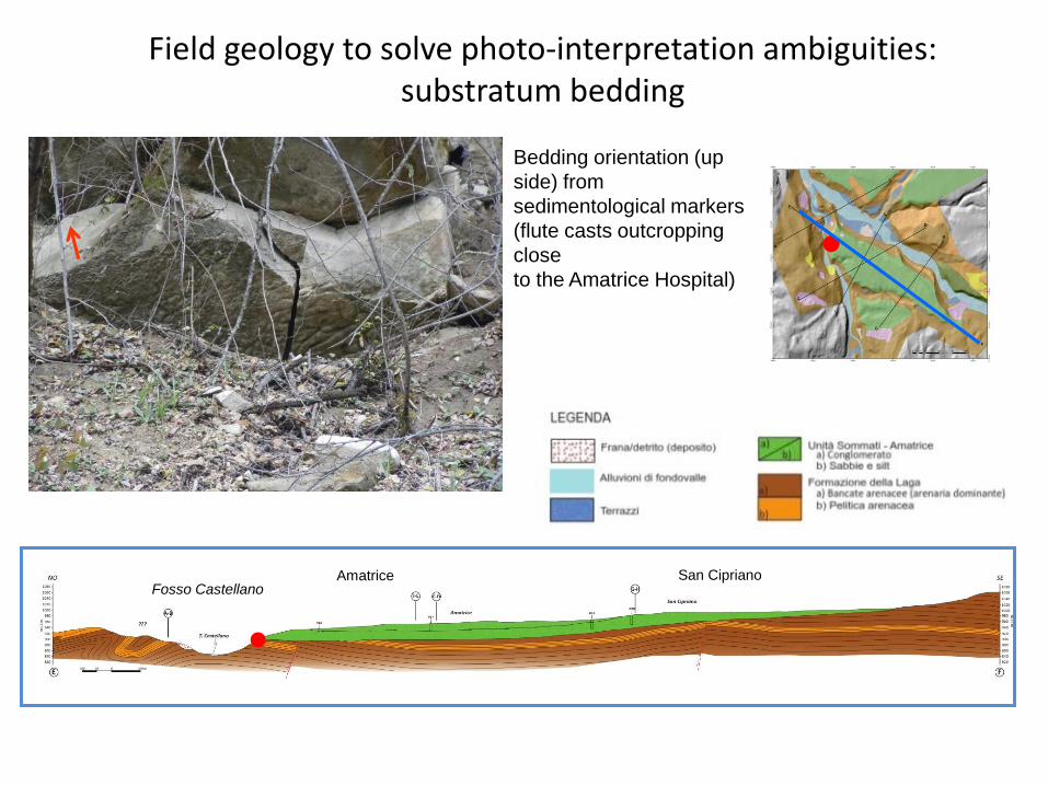
Field geology to solve photo-interpretation ambiguities: substratum bedding
Bedding orientation (up
side) from
sedimentological markers
(flute casts outcropping
close
to the Amatrice Hospital)
Fosso CastellanoAmatrice San Cipriano
New: LIDAR to support Photo-geological mapping. The Torrita basin
Concluding remarks
Photo-geological interpretation and mapping is a procedure which
allows to produce preliminary interpretations over wide areas in a short
time (~15km2 per day in this study) compared to field geology.
The Photo-geological Map should then be validated by field geology to
detail the local morpho-structural setting and to test preliminary
interpretations.
The integration between photo-geology and field geology is thus
an interactive and iterative process that allows to produce reliable
geological models from surface data, useful for:
1) planning new geophysical and geotechnical investigations,
2) providing a frame to the interpretation of acquired data
3) and defining an integrated subsoil model for MS