See discussions, stats, and author profiles for this publication at: https://www.researchgate.net/publication/248352105 Tertiary facies architecture in the Kutai Basin, Kalimantan, Indonesia Article in Journal of Asian Earth Sciences · February 1999 Impact Factor: 2.74 · DOI: 10.1016/S0743-9547(98)00035-X CITATIONS 39 READS 111 2 authors, including: Steve Moss Apache Deepwater LLC 21 PUBLICATIONS 582 CITATIONS SEE PROFILE All in-text references underlined in blue are linked to publications on ResearchGate, letting you access and read them immediately. Available from: Steve Moss Retrieved on: 02 May 2016
Tertiary facies architecture in the Kutai Basin, Kalimantan,Indonesia
Steve J. Moss a, 1, John L.C. Chambers b
aRobertson Research, 69 Outram Street, Perth, 6005, WA, AustraliabLASMO Runtu Ltd, Jakarta, Indonesia
Received 12 January 1998; accepted 22 June 1998
Abstract
The Kutai Basin occupies an area of extensive accommodation generated by Tertiary extension of an economic basement of
mixed continental/oceanic a�nity. The underlying crust to the basin is proposed here to be Jurassic and Cretaceous in age andis composed of ophiolitic units overlain by a younger Cretaceous turbidite fan, sourced from Indochina. A near completeTertiary sedimentary section from Eocene to Recent is present within the Kutai Basin; much of it is exposed at the surface as aresult of the Miocene and younger tectonic processes. Integration of geological and geophysical surface and subsurface data-sets
has resulted in re-interpretation of the original facies distributions, relationships and arrangement of Tertiary sediments in theKutai Basin. Although much lithostratigraphic terminology exists for the area, existing formation names can be reconciled witha simple model explaining the progressive tectonic evolution of the basin and illustrating the resulting depositional environments
and their arrangements within the basin. The basin was initiated in the Middle Eocene in conjunction with rifting and likely sea¯oor spreading in the Makassar Straits. This produced a series of discrete fault-bounded depocentres in some parts of the basin,followed by sag phase sedimentation in response to thermal relaxation. Discrete Eocene depocentres have highly variable
sedimentary ®lls depending upon position with respect to sediment source and palaeo water depths and geometries of the half-graben. This contrasts strongly with the more regionally uniform sedimentary styles that followed in the latter part of theEocene and the Oligocene. Tectonic uplift documented along the southern and northern basin margins and related subsidence ofthe Lower Kutai Basin occurred during the Late Oligocene. This subsidence is associated with signi®cant volumes of high-level
andesitic±dacitic intrusive and associated volcanic rocks. Volcanism and uplift of the basin margins resulted in the supply ofconsiderable volumes of material eastwards. During the Miocene, basin ®ll continued, with an overall regressive style ofsedimentation, interrupted by periods of tectonic inversion throughout the Miocene to Pliocene. # 1999 Elsevier Science Ltd.
All rights reserved.
1. Introduction
Borneo is bounded by three marginal oceanic basins
to the north and northeast (Fig. 1) and by mainland
SE Asia (Indochina and Peninsular Malaysia) to the
west and north west. To the north of Borneo is the
South China Sea, formed by sea¯oor spreading
between Borneo and South China of Oligocene to mid
Miocene age (Briais et al., 1993). To the south, separ-
ating Borneo from Java, is the shallow Java Sea,
underlain by Sundaland continental crust. Sundaland
crust is believed to extend into the southwestern corner
of Borneo, the Schwaner Mountains (Hamilton, 1979;
van de Weerd and Armin, 1992). To the east is the
deep Makassar Straits and Sulawesi.
Tertiary sedimentary basins, of which the Kutai
Basin is the largest, cover a signi®cant area of Borneo
(Fig. 1) and all appear to have a sedimentary ®ll de-
rived from the inland parts of Borneo, suggesting that
central Borneo was a�ected by extensive uplift anderosion during Tertiary times. In the central and
northern parts of Borneo, turbidites of the Late
Cretaceous±Early Tertiary Rajang and Embaluh
Groups cross the island in a NE±SW trending crescent
(Fig. 1). Where these turbidites have been extensively
eroded an underlying ophiolitic-type basement of
Jurassic-Early Cretaceous age is exposed. To the
south-west, the Schwaner Block, composed of
Journal of Asian Earth Sciences 17 (1999) 157±181
1367-9120/99 $ - see front matter # 1999 Elsevier Science Ltd. All rights reserved.
PII: S0743-9547(98 )00035 -X
PERGAMON
1 Formerly at University of London Southeast Asia Research
Group, Department of Geology, Royal Holloway, U.K.
S.J. Moss, J.L.C. Chambers / Journal of Asian Earth Sciences 17 (1999) 157±181158
Palaeozoic metamorphic rocks, form part of theSundaland continental crust. Both the Schwaner Blockand the Rajang/Embaluh Groups are intruded by con-siderable volumes of acidic to intermediate igneousmaterial that appears to range in age from EarlyCretaceous to Miocene. There is a shortage of reliableradiometric dating within Borneo as work done todate has relied almost exclusively on the K-Ar tech-nique.
2. Geological setting of the Kutai Basin
The Kutai Basin may divided into two (sub-) basins;a western Inner or Upper Kutai (sub-) Basin, and aneastern Outer or Lower Kutai (sub-) Basin. Today theUpper Kutai Basin is an area of major tectonic upliftas a result of Lower Miocene inversion of Paleogenedepocentres and the e�ects of subsequent erosion. Theboundaries of the Upper Kutai Basin are hard to con-strain, as it is likely that extensional tectonics inEocene times resulted in a patchwork of connectedand unconnected graben and half-graben extendingacross the eastern part of Borneo, and possibly rightacross the island (Pieters et al. 1987). These discretedepocentres are recognised from the Barito Basin inthe south through to the onshore Tarakan Basin in thenorth. The Lower Kutai Basin as we know it todaywas de®ned only during the Neogene, and overlies andencompasses many of the Palaeogene depocentres ofthe Upper Kutai Basin. The boundaries of the presentday Kutai Basin, or its Neogene equivalent, do notcorrespond to the margins of any single Palaeogenedepocentre. Many of the Palaeogene rifts were invertedand deeply eroded in the Neogene, further maskingtheir true extent. The deep Makassar Straits Basin onthe eastern side of the Kutai Basin (Figs. 1 and 2(a))represents the o�shore deep-water continuation of theKutai Basin, where the Neogene section thins ontowhat appears to be a Palaeogene block faulted section.The Makassar Straits Basin formed during the sameEocene extensional phase that gave rise to the in-itiation of the Kutai Basin (Moss et al., 1997).
The Lower Kutai Basin is bounded by two north-west-southeast trending fault zones; the Adang Faultto the south and the Sangkulirang Fault to the north.These fault zones and related o�sets extend bothonshore and o�shore (Cloke et al., 1997). South of theSangkulirang Fault, within the Kutai Basin, is theBungalun lineament (Fig. 2(b)), which together withthe Adang Fault de®nes the northern and southernboundaries of the Lower Kutai Basin. The Bungalunlineament has not previously been de®ned in the litera-ture but is a NW±SE trending lineament bordering thenorthern Lower Kutai Basin, controlling the path ofthe Bungalun River, and marking a rapid north±south
change from thin to thick Neogene sequences withinthe Lower Kutai sub-basin. The onshore Neogene sec-tion rapidly deepens between the Bungalun and Adangfaults. These hinge zones, or down-to-the-basin normalfaults, were active during the Late Oligocene toMiocene, and are probably sited upon older pre-exist-ing fault lines (Cloke et al., 1997). Similar parallel lin-ear features are present north of the MangkalihatPeninsula and within the Kutai Basin.
The Muller Mountains form the western margin ofthe Upper Kutai Basin and comprise predominantlyCretaceous turbidites of the Rajang and EmbaluhGroups. Similar Cretaceous turbidites crop out alongthe northern basin margin with, in places, moreseverely deformed Jurassic±Lower Cretaceous ophioli-tic rocks (Moss, 1998). A broadly arcuate feature,referred to as the `Muyup Hinge' (Fig. 4; Wain andBerod, 1989), trends roughly NE±SW across the KutaiBasin and appears to control the western margin ofthe Lower Kutai Basin. Interestingly this feature paral-lels the broad arcuate outcrops of the Embaluh Groupturbidites. The Muyup Hinge may be related to theunderlying geometry of Cretaceous basement metasedi-ments and acted as a zone of weakness during Tertiarydeposition.
The Tertiary history of the Kutai Basin includes aMiddle to Late Eocene syn-rift phase, a Late Eoceneto Oligocene sag phase and a renewed phase of tec-tonic activity and subsidence in the Late Oligocene toMiocene. Basin inversion, beginning at least as early asthe end of the Lower Miocene, resulted in reworkingof earlier sediments and ongoing deposition of `syn-inversion' deltaic packages. Continuing erosion fromthe hinterland, and from the Tertiary section, in re-sponse to Miocene and Pliocene tectonic activity,resulted in eastward prograding deltaic deposition(Chambers and Daley, 1995, Moss et al., 1997). In thispaper we document the depositional environments,their architecture and resultant facies of the di�erentphases of basin evolution from Eocene to present, aswell as presenting a discussion on the formation of theunderlying basement.
The Kutai Basin displays several gross geologicalfeatures repeated elsewhere in Southeast Asia, with aCenozoic basin ®ll overlying a thick Cretaceous turbi-dite section. The Middle Miocene to Pliocene deltaicsection makes up the only proven economic petroleumsystem, although hydrocarbons have been recoveredfrom Oligocene limestones, and to the south, in theBarito Basin, Eocene syn-rift sands of the TanjungFormation are productive oil reservoirs. Within theKutai Basin production began at the Sanga-Sanga ®eldin 1898, and to date in excess of three billion barrelsof oil and 30 TCF of gas have been recovered. A largevariety of petroleum systems can be expected in thisarea and, because of extensive outcrop, this is an ideal
S.J. Moss, J.L.C. Chambers / Journal of Asian Earth Sciences 17 (1999) 157±181 159
S.J. Moss, J.L.C. Chambers / Journal of Asian Earth Sciences 17 (1999) 157±181160
Fig.2.(b)simpli®ed
geologicalmapoftheKutaiBasin.
S.J. Moss, J.L.C. Chambers / Journal of Asian Earth Sciences 17 (1999) 157±181 161
place to study the elements of individual petroleumsystems±many of them no doubt past their prime. Thispaper however intends to describe the geology andfacies development in the area rather than the develop-ment of the petroleum systems.
3. Basement
3.1. Regional basement development
The nature of the basement surrounding and under-lying the Kutai Basin has attracted much discussion inthe literature (see Moss, 1998 for further discussion).We propose a new, and somewhat di�erent model forcrustal development in this area to those proposed byprevious workers, which we believe is consistent withregional observations, both internal and external tothe island of Borneo. There is clearly an interplaybetween continental and oceanic basement withinBorneo, with the southwest of the island made up ofthe Palaeozoic to Mesozoic Schwaner Block ofSundaland a�nity, while elsewhere, and on the mar-gins of the Kutai Basin, variably deformed, low grademetamorphosed Late Cretaceous±Early Tertiary turbi-dites of the Rajang and Embaluh Groups overlie olderbasic/ultrabasic igneous rocks and chert. These olderbasement rocks comprise peridotites, serpentinisedperidotites, layered gabbros, gabbros, basalts, chertand siliceous metasediments of Jurassic±EarlyCretaceous age (Moss, 1998). They are referred to asophiolitic assemblages, although extensive deformationmakes identi®cation of some parts of a `typical' ophio-lite sequence di�cult. We believe these highlydeformed, dismembered ophiolitic assemblages rep-resent Jurassic to Early Cretaceous age oceanic crust,although it is not clear if this ocean crust originated ina truly oceanic setting or in a back-arc ocean or mar-ginal ocean basin.
Ophiolitic rocks of Jurassic to Early Cretaceous ageoverlain by Late Cretaceous turbidites (now locallymetamorphosed) have also been described in theMeratus Mountains (Sikumbang, 1990), in the base-ment rocks on the northeastern and western marginsof the Kutai Basin (Moss, 1998), onshore TarakanBasin and Darval Bay in Sabah (Omang and Barber,1996) (Fig. 1). A similar relationship has also beendescribed in Western Sulawesi (Bergman et al., 1996).
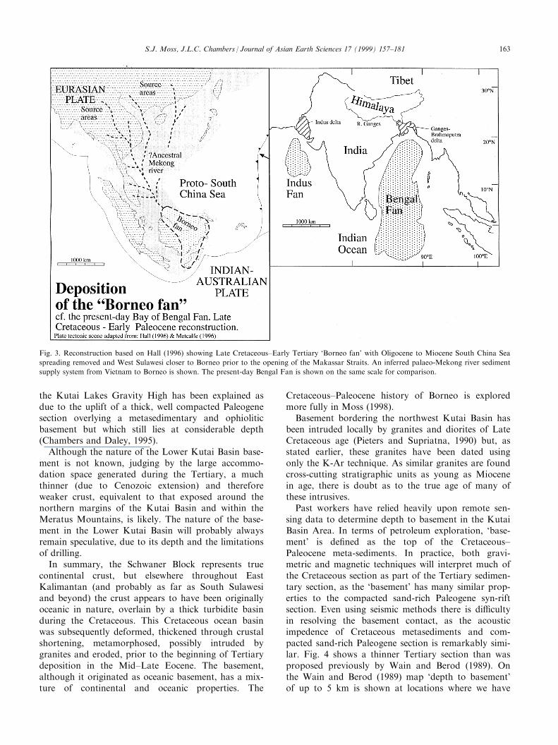
We propose that the regional occurrence of thickLate Cretaceous±Early Tertiary turbidites aboveophiolitic rocks, interpreted as Jurassic±EarlyCretaceous oceanic crust, suggests that a very largedeep marine turbidite fan system extended acrossBorneo during late Cretaceous times, perhaps similarto the present-day Bay of Bengal Fan in setting anddimensions (this is shown schematically in Fig. 3).
Such a fan system would be capable of depositing athick, areally extensive turbidite system. Moss (1998)describes the Embaluh and Rajang Group turbidites ofKalimantan and Sarawak in much greater detail andsuggest that these turbidites were deposited within aremnant oceanic basin during the Late Cretaceous.
3.2. Kutai Basin basement development
The northern and western margins of the KutaiBasin margins show thick low grade metamorphosedturbidites overlying serpentinites and ultra-basicigneous rocks and gabbros representing Jurassic toLower Cretaceous oceanic crust. To the south, wherethe margins include the highly deformed MeratusMountains and the continental Schwaner Block, thesituation is more complex.
Mesozoic ophiolitic and `island arc rocks' of theMeratus Mountains in the southeast corner of Borneo,and overlying turbiditic material of Cretaceous age,have been interpreted as forming a suture zonebetween continental and oceanic/intermediate crustaltypes (Sikumbang 1990). The true nature of the base-ment rocks on either side of the Meratus Mountains,and therefore on either side of this proposed suturezone, are poorly known. Given that the basementunits of the northern margin of the Kutai Basin aresimilar to the pre-Tertiary units of the MeratusMountains, and that Cretaceous meta-sediments wereencountered below the Tanjung ®eld (northern BaritoBasin west of the Meratus Mountains; Fig. 2(a)), theMeratus Mountains may also be uplifted oceanic base-ment with overlying Cretaceous metasediments. Wesuggest that the Meratus Mountains, and their north-ward plunging continuation, represent a major inver-sion axis throughout East Kalimantan, and that thesemountains once formed the basement of a majorEocene graben system which was exhumed during theEarly Miocene inversion event.
A NNE±SSW trending gravity high, the KutaiLakes Gravity High (Wain and Berod, 1989, Fig. 2(b)),extends north from the Meratus Mountains in thesouth, to the Gongnyay area in the north. The KutaiLakes Gravity High is o�set along NW±SE lineamentswhich parallel the trends of the Adang, Sankulirangand Bungalun lineaments (Wain and Berod, 1989;Chambers and Daley, 1995; Cloke et al., 1997). Wewould therefore link the Meratus Mountains and theGongnyay area as major inversion features, where dee-ply buried Paleogene rift sediments, overlyingCretaceous metasediments and older ophiolitic ma-terial, have been uplifted during the Miocene. In thecase of the Meratus Mountains, inversion has been re-sponsible for bringing basement to the surface, but atGongnyay, surface exposures comprise compactedPalaeogene sediments. Within the Lower Kutai Basin,
S.J. Moss, J.L.C. Chambers / Journal of Asian Earth Sciences 17 (1999) 157±181162
the Kutai Lakes Gravity High has been explained asdue to the uplift of a thick, well compacted Paleogenesection overlying a metasedimentary and ophioliticbasement but which still lies at considerable depth(Chambers and Daley, 1995).
Although the nature of the Lower Kutai Basin base-ment is not known, judging by the large accommo-dation space generated during the Tertiary, a muchthinner (due to Cenozoic extension) and thereforeweaker crust, equivalent to that exposed around thenorthern margins of the Kutai Basin and within theMeratus Mountains, is likely. The nature of the base-ment in the Lower Kutai Basin will probably alwaysremain speculative, due to its depth and the limitationsof drilling.
In summary, the Schwaner Block represents truecontinental crust, but elsewhere throughout EastKalimantan (and probably as far as South Sulawesiand beyond) the crust appears to have been originallyoceanic in nature, overlain by a thick turbidite basinduring the Cretaceous. This Cretaceous ocean basinwas subsequently deformed, thickened through crustalshortening, metamorphosed, possibly intruded bygranites and eroded, prior to the beginning of Tertiarydeposition in the Mid±Late Eocene. The basement,although it originated as oceanic basement, has a mix-ture of continental and oceanic properties. The
Cretaceous±Paleocene history of Borneo is exploredmore fully in Moss (1998).
Basement bordering the northwest Kutai Basin hasbeen intruded locally by granites and diorites of LateCretaceous age (Pieters and Supriatna, 1990) but, asstated earlier, these granites have been dated usingonly the K-Ar technique. As similar granites are foundcross-cutting stratigraphic units as young as Miocenein age, there is doubt as to the true age of many ofthese intrusives.
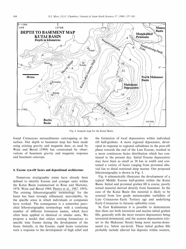
Past workers have relied heavily upon remote sen-sing data to determine depth to basement in the KutaiBasin Area. In terms of petroleum exploration, `base-ment' is de®ned as the top of the Cretaceous±Paleocene meta-sediments. In practice, both gravi-metric and magnetic techniques will interpret much ofthe Cretaceous section as part of the Tertiary sedimen-tary section, as the `basement' has many similar prop-erties to the compacted sand-rich Paleogene syn-riftsection. Even using seismic methods there is di�cultyin resolving the basement contact, as the acousticimpedence of Cretaceous metasediments and com-pacted sand-rich Paleogene section is remarkably simi-lar. Fig. 4 shows a thinner Tertiary section than wasproposed previously by Wain and Berod (1989). Onthe Wain and Berod (1989) map `depth to basement'of up to 5 km is shown at locations where we have
Fig. 3. Reconstruction based on Hall (1996) showing Late Cretaceous±Early Tertiary `Borneo fan' with Oligocene to Miocene South China Sea
spreading removed and West Sulawesi closer to Borneo prior to the opening of the Makassar Straits. An inferred palaeo-Mekong river sediment
supply system from Vietnam to Borneo is shown. The present-day Bengal Fan is shown on the same scale for comparison.
S.J. Moss, J.L.C. Chambers / Journal of Asian Earth Sciences 17 (1999) 157±181 163
found Cretaceous metasediments outcropping at thesurface. Our depth to basement map has been madeusing existing gravity and magnetic data, as used byWain and Berod (1989) but constrained by obser-vations of basement gravity and magnetic responseand basement outcrops.
4. Eocene syn-rift facies and depositional architecture
Numerous stratigraphic terms have already beende®ned to identify Eocene and younger units withinthe Kutai Basin (summarised in Rose and Hartono,1978; Wain and Berod 1989; Pieters et al., 1987, 1993).The existing lithostratigraphic terminology for thebasin has been strongly in¯uenced, unavoidably, bythe speci®c areas in which individuals or companieshave worked. The consequence is a somewhat paro-chial lithostratigraphic terminology with a confusingnumber of di�erent formation names, which haveoften been applied to identical or similar units. Wepropose a model that relates existing formations tospeci®c time frames during the development of thebasin. Initially, in the Eocene, rapid facies variationswere a response to the development of high relief and
the formation of local depocentres within individual
rift half-grabens. A more regional depocentre, devel-
oped in response to regional subsidence in the post-riftphase towards the end of the Late Eocene, resulted in
a more continuous facies distribution which has con-tinued to the present day. Initial Eocene depocentres
may have been as small as 20 km in width and con-
tained a variety of facies ranging from proximal allu-vial fan to distal restricted deep marine. Our proposed
lithostratigraphy is shown in Fig. 5.
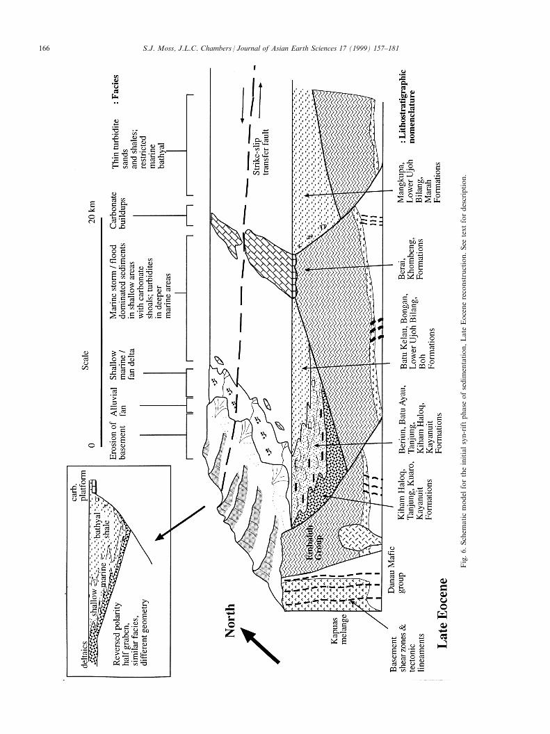
Fig. 6 schematically illustrates the development of a
typical Middle Eocene half-graben within the KutaiBasin. Initial and proximal graben ®ll is coarse, poorly
sorted material derived directly from basement. In the
case of the Kutai Basin this material is likely to besourced from low grade metamorphic turbidites of
Late Cretaceous±Early Tertiary age and underlyingEarly Cretaceous to Jurassic ophiolitic crust.
In East Kalimantan it is possible to demonstratethat there are both terrestrial and marine initial graben
®lls, generally with the more western depocentres being
terrestrial-dominated, and the eastern depocentres (clo-ser to the Makassar Strait) being more marine-domi-
nated (i.e. below sea-level). These initial graben ®llsprobably include alluvial fan deposits within western,
Fig. 4. Isopach map for the Kutai Basin.
S.J. Moss, J.L.C. Chambers / Journal of Asian Earth Sciences 17 (1999) 157±181164
S.J. Moss, J.L.C. Chambers / Journal of Asian Earth Sciences 17 (1999) 157±181 165
Fig.6.Schem
aticmodel
fortheinitialsyn-riftphase
ofsedim
entation,Late
Eocenereconstruction.See
textfordescription.
S.J. Moss, J.L.C. Chambers / Journal of Asian Earth Sciences 17 (1999) 157±181166
interior rifts but may be entirely marine in the easternrifts (Fig. 6). Polarity of half-graben bounding faultsstrongly a�ects facies stacking patterns, and there isgood evidence to suggest that during Eocene rift for-mation a complex series of opposing polarity half-gra-bens developed, o�set along rift-related transformfaults (Cloke et al., 1997).
With progressive rifting, marine transgression or re-gional subsidence, there was an overall change in thedepositional environment from non-marine progress-ively through to shallow marine/coastal to shelf, andeventually bathyal marine environments, within thewestern rifts. In a relatively small graben depocentre itmay be possible to view progressively almost all faciesassociations along one time line, within a distance of20 km (Fig. 6). Within the eastern rifts, more directlyin¯uenced by marine conditions from the onset of rift-ing, bathyal marine environments were more quicklyestablished. Factors controlling facies include: sedi-ment source and abundance, climate, rate of faultmovement and subsidence, and overall architecture ofthe graben system. In shallow marine areas, removedfrom sediment input, carbonate platforms developed.Deeper marine basins, with only small amounts ofcoarse sediment input, developed thick shale sections.Sand-rich graben ®lls occur in depocentres linkeddirectly to eroding basement.
Given that during the Eocene a patchwork of riftbasins were formed across the East Kalimantan areain response to regional extension, lithostratigraphic ter-minology must be used with extreme caution and itmust be recognised that lithostratigraphic terms canonly be used to group similar facies groups that mayor may not be time or genetically equivalent. Detailedbelow are the standard lithostratigraphic terms for theUpper Kutai Basin, the facies described for these for-mations and their interpreted relationship to Eocenerift systems (Fig. 6). We have sub-divided the periodof basin evolution into distinct time slices and have il-lustrated the range of depositional environments andresultant facies, which we have termed facies tracts.We have attempted to list all previously used lithostra-tigraphic names for these sediments.
4.1. Non Marine Syn-rift Facies Tract (Fluvial±AlluvialFan Coarse Conglomerate and Sandstone Facies±LowerKiham Haloq Sandstone Formation; TanjungFormation, Kuaro Formation)
In the northwest corner of the Kutai Basin, thebasal contact of the Tertiary sequence is well exposedin several river sections. The basal sections of theKiham Haloq Sandstone Formation type-section con-sist of channel bodies (Fig. 7(a)), and epsilon cross-bedding within channels indicates lateral migration ofaccretion surfaces. Coarse conglomerate basal lags,
and ®ning-up beds are present and suggestive of ¯uvialdeposition processes (Pieters et al., 1993; Wain andBerod, 1989; Moss et al., 1997). Alluvial fan sands andconglomerates, similar to those of the Kiham HaloqSandstone Formation, have not been observed in thenortheast part of the Kutai Basin. It is possible that,since this section occupies the deepest part of graben,it has not been brought to the surface through inver-sion and hence is not exposed in most areas.Alternatively, fan deltaic deposits of the BeriunFormation may be the time equivalent deposits in gra-ben systems more distal and marine with respect toeroding basement.
Middle Eocene deposition along the southern mar-gins of the Kutai Basin and within the Barito Basinalso initially included non-marine sands, coals andconglomerates of the Kuaro and Lower TanjungFormations (Fig. 5; van de Weerd et al., 1987). Thepresence of coarse conglomerates within the TanjungFormation led to the interpretation of extensionalfaulting a�ecting this area of the basin (van de Weerdand Armin, 1992), although the Eocene structural styleis poorly resolved on available seismic data. TheLower Tanjung Formation comprises a braided streamfacies, passing up into a sandy ¯uvial facies (van deWeerd et al., 1987). These in turn pass laterally andvertically into the deltaic and shallow marine faciesdescribed below.
4.2. Deltaic Syn-rift Facies Tract (Sandstones,Conglomerates, Coals, Shales of the Beriun Formation,Batu Ayau Formation, Lower Tanjung Formation,Sembakung Formation, Kayanuit Formation)
The Beriun Formation is a sand-rich delta systemwhich crops out within inverted graben structures inthe northern part of the basin, (Sunaryo et al., 1988;Satyana and Biantoro, 1995; van de Weerd andArmin, 1992). Lithologies comprise continental sand-stones, shales and coals, as well as ¯uvio-deltaic andmarine sandstones and shales, with rare limestones.Conglomerates associated with coals and shallow mar-ine sediments of the Beriun Formation are time equiv-alent to the non-marine facies tract of the rift phase.Sunaryo et al. (1988) described 600±700 m of conglom-erates interbedded with sandstones in the BeriunFormation. Fluvio-deltaic sedimentary features such asthick cross-bedded channel sands with scoured con-glomeratic bases, and thick carbonaceous shales andcoals, are common, together with immature conglom-erates containing abundant basement fragments.Typical delta mouth bar facies, marine bioturbatedintervals and occasional limestones con®rm that this isa marine, and not a lacustrine system. Benthonic fora-minifera, when found, frequently indicate bathyaldepositional environments, suggesting a steep basin
S.J. Moss, J.L.C. Chambers / Journal of Asian Earth Sciences 17 (1999) 157±181 167
slope into a slightly restricted sub-basin during Eocenetimes. Time-structure maps presented by Satyana andBiantoro (1995) clearly show sediment thicknesseswithin the Beriun Formation controlled by extensionalfaults, and demonstrate that faulting occurred during
deposition by the growth of section from the upthrownto the downthrown side of the fault block. All of thesefeatures are consistent with deltaic deposition duringlocalised subsidence along extensional faults, such asthe Gongnyay Fault, and rapid syn-rift deposition.
Fig. 7. (a) Field photo of a ¯uvial channel incised into an earlier channel within the early syn-rift facies of the Middle Eocene Kiham Haloq
Sandstone Formation. Upstream from Long Bangun. Ian Cloke for scale; (b) ®eld photo of upward bundling wave ripple above planar laminated
sands within Middle to Late Eocene marine syn-rift facies. Belayan River upstream from Tabang. Coin for scale; (c) ®eld photo, looking south,
of folded distal turbidites of the Batu Kelau Formation part of the marine shale and turbidite syn-rift facies. Wahau river upstream from Muara
Wahau. The east vergent fold is located in the hanging-wall of a thrust, formed in response to Early Miocene inversion; (d) ®eld photo of re-
deposited limestone conglomerate composed of siliciclastic clasts (cherts and dark metasediments) and clasts of re-deposited shallow water car-
bonates including corals. Part of the Late Oligocene platform carbonate facies. North of Muara Wahau.
S.J. Moss, J.L.C. Chambers / Journal of Asian Earth Sciences 17 (1999) 157±181168
From a seismic stratigraphic study Satyana andBiantoro (1995) proposed a syn-rift fan delta faciesmodel for the Beriun Formation. This model is sup-ported here.
In the northwestern part of the Kutai Basin, sands,shales, mudstones and coals of the Batu AyauFormation are equivalent in age to the Kiham HaloqSandstone and Batu Kelau Formation. The Batu AyauFormation comprises ®ne to medium quartzose sands,thin coals, muds, shales and carbonaceous shales.
Mudstones and shales are often heavily bioturbated.Wain and Berod (1989) recognised three subdivisionsof the Batu Ayau. A ¯uvial lower part and two uppermarine divisions re¯ect regression and continental styledeposition, followed by transgression and a return tomarine deposition on an open, low energy shelf withlow clastic input. These sediments are analogous to theLower Berai Formation of the southern part of thebasin (van de Weerd et al., 1987) and the BeriunFormation, but were deposited within di�erent discrete
Fig. 7Ðcontinued
S.J. Moss, J.L.C. Chambers / Journal of Asian Earth Sciences 17 (1999) 157±181 169
depocentres. The Lower Tanjung Formation, of thesouthwestern part of the Kutai Basin or the northernBarito Basin, similarly contains a paralic-deltaic facies(van de Weerd et al., 1987).
4.3. Shallow Marine Syn-rift Facies Tract (MatureSandstones and Carbonates of Upper Kiham HaloqSandstone Formation, Ritan Limestone Member ofUpper Kiham Haloq Sandstone Formation, Parts ofBatu Ayau Formation, Lower Tanjung Formation, Partsof the Batu Kelau Formation)
Within the northwest corner of the basin, exposuresof non-marine, deltaic, syn-rift facies tracts pass verti-cally and laterally into well-sorted, medium- to coarse-grained sandstones of the Batu Kelau Formation.These sandstones contain hummocky cross strati®ca-tion, swaley cross strati®cation, large trough cross-bed-ding, megaripples, planar laminations and wave ripples(Fig. 7(b)), as well as trace fossils of the Skolithus andCruziana ichnofacies. Metre-scale lenses of foraminif-eral packstones and grainstones dominated by largerforaminifera such as Nummulites and Discocyclinidsare intercalated with these sands. These carbonates,include the Ritan Limestone member of the KihamHaloq Sandstone Formation, formed within a highenergy, occasionally storm- or ¯ood-dominated shal-low marine shelfal setting. The presence locally of her-ring-bone cross-strati®cation and reactivation surfaceswithin mature, medium-grained quartz sandstones in-dicate tidal conditions were present at times.
The Lower Tanjung Formation in the southwestcorner of the basin contains shallow marine clasticsediments that overlie and are probably laterally equiv-alent to deltaic and alluvial facies of the same for-mation (described above, van de Weerd et al., 1987).Thus the northern and southern margins of the basinshow remarkably similar successions of sediment,although individual depocentres are unlikely to havebeen continuous throughout the basin.
4.4. Marine Shale and Turbidite Syn-rift Facies Tract.(Thin Turbidite Sands and Shales, Restricted Marine(?)Bathyal, Middle to Upper Eocene±MangkupaFormation, Marah Formation, Parts of the Batu KelauFormation, Bongan Formation, Lower Ujoh BilangFormation, Atan Formation, Boh Formation)
The Mangkupa Formation (Sunaryo et al., 1988) isa shale-rich, deep marine facies that has been inter-sected in wells at least 80 km east of the present base-ment outcrop (Fig. 2(a)), and also occurs in outcrop inthe northeastern part of the Kutai Basin. It is notice-ably di�erent from the sand-rich Beriun Formation(described above) that in®lls the Gongnyay Graben(Fig. 2(a)), and may be the distal marine equivalent or
the product of sand-starved extensional depositionalsettings. Recent revisions in palaeontological environ-mental interpretation suggest that the section is poss-ibly not entirely deep marine (bathyal to abyssal) aspreviously supposed, but may in part restricted marineand isolated intra-shelf basins (A. Wonders, pers.comm. 1996).
The Batu Kelau Formation occurs in the northwestcorner of the basin, and comprises dark shales inter-bedded with siltstones and ®ne sandstones (Fig. 7(c)).Sandstone beds range in thickness from four to twelvecentimetres, may show grading and partial Boumasequences, and often show load casts and groove casts.Trace fossils, although common in some beds, haveminimal diversity and comprise simple feeding andgrazing trails belonging to the Zoophycos ichnofacies.The formation contains a rich and biostratigraphicallyuseful nannofossil fauna along the upper reaches ofthe Belayan River, dating the formation as LateEocene (P14±P15; Moss and Finch, 1998). The abun-dance of nannoplankton within these sediments, andthe ichnofacies, suggest a deep marine, low-energy en-vironment. Collectively the data indicate a deep water,open marine environment, a�ected occasionally by tur-bidity currents. Other workers have suggested an inter-tidal to shallow sub-tidal (Wain and Berod, 1989) orestuarine (Pieters et al., 1993) setting. We consider thata deeper marine environment, analogous to theBongan Formation in the southern part of the basin(van de Weerd et al., 1987) is more appropriate.Proximal and distal slope and basinal facies are recog-nised within the Bongan Formation (Fig. 6).
4.5. Carbonate Platform Syn-rift Facies Tract (LowerBerai, Ritan Limestone Member of Keham HaloqSandstone Formation)
A variety of Eocene carbonate occurrences havebeen documented within the basin. Near to the north-ern margin, carbonates appear to have formed lowrelief shoals, bound by algae, but with a high shalecontent, suggesting proximity to a muddy, ¯uvial dis-charge system. Isolated smaller bodies of limestone arealso found associated with deltaic sediments in theGunung Gongnyay area (Fig. 2(a)) and probably rep-resent a minor facies within the delta fairway thatdeveloped in areas of low clastic input. Some of thesecarbonates may have developed in shallow shelf sedi-ment-starved settings and formed as patch reefs orshoals. These probably developed on basement highsadjacent to rift depocentres. Larger carbonate build-ups and isolated platforms of Eocene age are visible atoutcrop, for example along the Bungalun River(Fig. 2(a)) and the large limestone outlier of GunungKhombeng (near Muara Wahau, Fig. 2) within thenortheast of the basin. Isolated buildups such as
S.J. Moss, J.L.C. Chambers / Journal of Asian Earth Sciences 17 (1999) 157±181170
Gunung Khombeng appear to have nucleated uponthe uplifted crest of footwall blocks (Fig. 6). Duringthe Late Eocene, on both the northern and southernmargins of the basin, extensive carbonate platformswere developed. For example Upper Eocene argillac-eous limestones with larger foraminifera occur belowOligocene carbonates in the Panain-Gunung Anga andKerenden areas of the southern margin of the basin(Saller et al., 1992, 1993) as well as in the BungalunRiver Area (Wilson et al., 1998).
5. Upper Eocene to Oligocene sag phase facies anddepositional architecture
By the end of the Eocene, extension in the MakassarStrait and associated forces within East Kalimantanappear to have ceased and regional subsidenceoccurred throughout East Kalimantan (Moss et al.,1997). Instead of local depocentres, as observed withinthe syn-rift half-grabens, a more regional depocentredeveloped as a result of marine inundation of much ofthe area (Fig. 8). On isolated high areas, and on mar-gins of the basin, carbonates continued to accumulate,but within the basinal area a regional marine shalewas deposited. It seems likely that by this time muchof the topographic relief created during the Mid-Eocene had been removed, as input of coarse clasticsediment into the basin became very limited. The sag
phase of sedimentation continued into the LateOligocene, when East Kalimantan was once again dis-rupted by a major extensional tectonic event.
5.1. Basinal Shale Sag Phase Facies Tract(Monotonous Shales with Thin Turbiditic Sands, UjohBilang Formation, Bongan Formation, Atan Formation,Wahau Formation, Marah Formation)
A monotonous, marine shale-prone unit, conform-able and transitional with the underlying rift-relatedformations, is described as the Ujoh Bilang Formationwithin the Upper Kutai Basin, and as the BonganFormation in the southern part of the basin. It is notpossible to distinguish this formation from the under-lying marine syn-rift formations such as theMangkupa, Marah or Batu Kelau Formations, withwhich it is transitional. The major part of the UjohBilang Formation comprises uniform, monotonousshales and clays, with rare sandstones, deposited in anouter shelf to bathyal environment. Sporadic depo-sition from distal turbiditic currents is evidenced bythe presence of thin sandstones with full and partialBouma sequences. Similarly, the Wahau Formationfrom the Muara Wahau area is described as consistingof claystones and thin quartz sandstones by Supriatna(1990), deposited in an open marine, outer shelf setting(Pieters et al., 1993; Moss et al., 1997).
Fig. 8. Schematic model for the Early to Late Oligocene. See text for description.
S.J. Moss, J.L.C. Chambers / Journal of Asian Earth Sciences 17 (1999) 157±181 171
Within the Tanjung ®eld in the northern part of theBarito Basin, the Lower Oligocene Bongan Formationcontains interbedded lithoclastic±bioclastic conglomer-ates, limestone olistoliths and carbonate and volcani-clastic turbidite beds (van de Weerd et al., 1987),suggested to represent distal slope to basinal facies.According to Wain and Berod (1989) and van deWeerd and Armin (1992), the Lower Ujoh BilangFormation also contains volcanogenic rich sandstonesof the Len Muring Sandstone member, with volcani-clastic, quartz and bioclastic grains, deposited as debrisand mass ¯ows in a deep marine environment.
Shale of this facies tract has been demonstrated tolie directly upon basement, indicating that thissequence was a response to transgression that coveredboth syn-rift sediments and surrounding basementareas. The Ujoh Bilang Formation represents a re-gional shale `blanket' over the syn-rift lithologies andsigni®es the establishment of deep marine sag phaseenvironments in the Lower Oligocene (Fig. 8).
5.2. Carbonate Sag Phase Facies Tract (Thick ShallowMarine Carbonates Batu Belah Limestone Member,Berai Formation, Taballar Formation, Batu HidupFormation, Kedango Limestone)
In parts of the basin, carbonate deposition was con-tinuous from the Late Eocene to the Late Oligocenesag phase, but restricted to basement high areas suchas the Bungalun River and Kerenden, and to basinmargin areas (van de Weerd et al., 1987; Saller et al.,1992, 1993; Moss et al., 1997). Carbonates on thenorthern side of the basin are less well-known (seeWilson et al., 1998) but are analogous in age andfacies to the Berai Limestone of the Upper BeraiFormation on the southern basin margin (van deWeerd et al., 1987; Saller et al., 1992, 1993). The lo-cation of antecedent topography, such as basementhighs and crests of fault blocks, still clearly in¯uencedthe development of this facies within the basin (Fig. 8).
The Batu Baleh Limestone Member of the UjohBilang is a land-detached, isolated buildup within thenorth west part of the basin. Previous work, primarilybased on benthic foraminifera, suggested that thesecarbonates were of Lower Oligocene age (Pieters et al.,1993; Wain and Berod, 1989). However, more recentwork (Moss and Finch, 1998), based primarily upon awell-preserved nannofossil fauna, clearly shows theselimestones to be of Upper Oligocene age (NP24±25).These carbonates may have developed on an intra-basin basement high associated with an intra-basinpositive gravity anomaly (Moss et al., 1997).
6. Late Oligocene events in the Kutai Basin and Borneo
An important unconformity occurs within theUpper Oligocene sediments of the Kutai Basin, appar-ently related to a renewed pulse of extension and upliftof central Kalimantan. Oligocene extensional faultsdeveloped orthogonal to Eocene extensional faults,suggesting a di�erent stress regime. It seems likely thatOligocene faulting follows pre-existing crustal planesof weakness, particularly northwest-southeast trendingtransform faults that separated Eocene graben systems.An attempt has been made to show this relationship inFig. 9. The present Kutai Basin, as we presently recog-nise it, formed at this time, with the Sangkulirang andBungalun faults in the north and the Adang Faultzone in the south as the principal hinge zones. Thesefaults acted as down-to-the-basin hinge zones from theLate Oligocene to early Miocene.
Moss et al. (1998) detailed the evidence for lateOligocene cooling of the late Cretaceous±Paleocenemetasedimentary basement along the northwesternmargin of the Kutai Basin. From apatite ®ssion-trackdata they suggested a tectonic cause for the coolingand likely uplift of the area. Apatite central ages spana range between 40 and 20 Ma, clustering between 20±25 Ma. The data are interpreted as indicating that thesamples began cooling, and hence probably began tobe eroded, from 025 Ma onwards, and that theuplifted Cretaceous Embaluh Group provided sedi-ment for Early Miocene deposition in eastern parts ofthe basin from025 Ma onwards. This sediment sourceis consistent with petrographic data from Miocenereservoirs of the Sanga Sanga PSC near the easternmargin of the basin (Tanean et al., 1996).
6.1. Post025 Ma Basinal Sag Phase Facies Tract(Upper Ujoh Bilang Formation, Marah Formation,Pamaluan Formation)
In basinal areas deposition was continuous (butprobably in a more distal deeper-water environment)from the underlying sag phase. The Lower UjohBilang Formation is transitional with the Upper UjohBilang Formation or Marah Formation. Rare turbidi-tic sands and limestones occur within the shalesequence (Fig. 9). In the northwest of the basin theUpper Ujoh Bilang Formation contains a minor volca-nic presence in the form of the Ujoh Bilang VolcanicSeries (Wain and Berod, 1989). Volcanic debris-richsandstones of the Len Muring Sandstone Memberhave been described previously (in this paper) andpossibly also belong to this suite. This tectonic eventin the Late Oligocene was responsible for a radicalchange in basin architecture and hence disrupted thestable sag phase architecture by introducing sharptopographic changes and a new and abundant sedi-
S.J. Moss, J.L.C. Chambers / Journal of Asian Earth Sciences 17 (1999) 157±181172
Large carbonate platforms, variably referred to asthe Batu Hidup Formation or Berai Formation, beganto develop during the Late Oligocene (Fig. 9) but werefrequently established on pre-existing carbonate plat-forms. In the northern part of the basin, initially, athin shelf limestone, sometimes referred to as theKedango Limestone, was deposited across much of thearea in response to shallowing of the depositional en-vironment during the early part of the Late Oligocenetectonic event. The Kedango Limestone acts as a re-gional marker horizon, clearly visible on both SARimages and seismic data, eventually disappearingbasinward to the south, as the facies changes to bath-yal shale. The Batu Hidup Limestone developed abovethe Kedango Limestone, in areas of suitable waterdepth and presumably low clastic input. The BatuHidup Limestone consists of reef and platform carbon-ates up to 1000 m thick that form large karsti®ed areasat outcrop. The limestones contain identi®able coral
material in a generally foraminiferal wackestone topackstone matrix. Surrounding these areas of lime-stone, coeval basinal sediments contain numerous bedsof calci-turbidites and carbonate-rich debris ¯ow con-glomerates (Fig. 7(d)). Four lithofacies recognisedwithin these redeposited limestones are shown inFig. 10. These units contain numerous clasts of shal-low marine carbonate (such as corals and blocks oflithi®ed wackestone and packstone) as well as litho-clastic fragments (such as chert and sandstone). Theseturbidites and redeposited limestones may be the pro-duct of highstand shedding and progradation of theplatforms as described from the Berai Limestone onthe southern margin of the basin (Saller et al., 1992,1993) and many other carbonate platforms (cf.Droxler and Schlager, 1985; Davies et al., 1989; Emeryand Meyers, 1996). Alternatively, some may have beenderived from an uplifted footwall crest, analogous toEocene to Miocene redeposited limestones of SWSulawesi (Wilson and Bosence, 1996) although a moredetailed study is required. Along the southern basinmargin a similar facies succession has been describedwith the Berai Limestone, forming on the stable plat-form south of the Adang Fault Zone. Isolated plat-form areas such as Kerenden have been describedbasinward of the Adang Fault Zone (van de Weerdand Armin, 1992).
Fig. 10. Representative lithological columns for four common redeposited limestones lithofacies found in Late Oligocene to Early Miocene peri-
platform deposits.
S.J. Moss, J.L.C. Chambers / Journal of Asian Earth Sciences 17 (1999) 157±181174
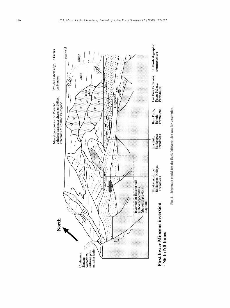
7. Lower Miocene facies and depositional architecture
The Early Miocene was a period of overall re-gression and basin ®lling with the beginning of progra-dation of the proto-Mahakam River and associateddeltaic sediments. Sediment continued to be sourcedfrom Mesozoic cherts and turbidites that were upliftedduring the Late Oligocene tectonic event. Further sedi-ment sources were provided by uplifted Paleogene sedi-ments in western parts of the basin and volcanicmaterial from the volcanoes of the Sintang extrusivesthat were active at this time.
7.1. Lower Miocene Deep Marine Post-second RiftEvent Facies Tract (Sandstones and Shales of theWahau Formation, Lawa Formation, Ritan Formation,Pamaluan Formation, Loa Duri Formation)
Extensive outcrops of Lower Miocene (N4±N6 BlowZone) interbedded sandstones and shales of theWahau Formation outcrop to the southeast of MuaraWahau (the Bungalun to Khombeng road section,Hainim and Chambers, 1994). These sandstones andshales show partial Bouma sequences, sandstone bedamalgamation, current ripple lamination, dish struc-tures, metre-thick, generally massive sandstone beds,®ning-up sandstone beds and coarsening-upward deci-metre cycles or parasequences. Sole structures in theform of groove and load casts and prod marks arecommon, as are large syn-sedimentary slumps andsandstone dykes. A transport direction to the south-east is suggested from the sole structures. There was apronounced increase in the proportion of sand beingdeposited during N4±N6 times, most likely in responseto the changing basin topography initiated during thelatest Oligocene (0N3 times) tectonic event (Fig. 9).The presence of bathyal foraminifera in adjacent shalesindicate that these are probably slope mass-¯ow depos-its, part of an extensive pro-delta turbidite submarine-fan system that was established across this area in re-sponse to movement on the Bungalun to KhombengFault and a sudden deepening of the basin southward.Sands are rich in volcanic fragments derived from theSintang volcanoes, active during the Late Oligoceneand Early Miocene (see below). Some intervals alsoshow debris ¯ows of coarse carbonate material derivedfrom the adjacent carbonate shelf areas.
To the west within the Tinjau (Fig. 2(a)) and UpperMahakam areas the same stratigraphic interval is moreproximal and coarser grained with conglomerates pre-sent in the Ritan Formation. Closer to the southernbasin margin a similar facies style is apparent in thedepocentre formed adjacent to the Adang Fault Zoneand is ®lled with a type of turbidite sediments similarin nature to those described near the northern basin
margin. This is referred to as the PamaluanFormation.
7.2. Lower Miocene (N6±N8 Blow Zone) DeltaicFacies Tract (Shallow Marine to TerrestrialSandstones, Claystones and Coals of the LowerBalikpapan Beds, Pamaluan Formation, WahauFormation. Shallow Marine Carbonates of the LowerMiocene (N6±N8)±Pulau Balang Formation, Loa KuluFormation, Bebulu Formation)
Deltaic progradation in the Kutai Basin beganduring N5/6 times (van de Weerd and Armin, 1992)(Fig. 11) and is apparently transitional with the thickturbidite and bathyal shale sequence described in theprevious section, thus representing an overall continu-ing regressive sequence, as sediment supply outstrippedaccommodation. In the Samarinda area deltaic sedi-mentation was not established until N8 time.
Lithofacies terminology for the Neogene deltaic stra-tigraphy in the Kutai Basin has become increasinglyconfused, largely through misunderstandings of thenature of cyclic deltaic stratigraphy, and a widespreadmisunderstanding of the nature and timing of tectonicinversion events and their e�ects on the style and ratesof sedimentation within the basin. An original lithos-tratigraphic framework was proposed by Leupold andvan der Vlerk (1931) based on long range shallow mar-ine foraminifera and the lithological succession seen inthe Balikpapan Bay to Sanga Sanga Area. This systemwas slightly modi®ed by Marks et al. (1982). Analternative system was proposed by Land and Jones(1987) as a result of regional coal exploration work inthe Samarinda Area. Although Land and Jones (1987)based their study on extensive coal drilling results theyfailed to recognise the stratigraphic inter-relationshipof the three units; Loa Kulu Formation, BatuputihLimestone and Loa Duri Formation.
Chambers et al. (1992) demonstrated a more consist-ent stratigraphic relationship for the units proposed byLand and Jones (1987) based on extensive ®eld workcarried out by LASMO Runtu Limited. In this laterstratigraphic nomenclature the Batuputih Limestone(equivalent to the Bebulu Formation) is interpreted asa transitional shelf deposit between the deep marineLoa Duri Formation (elsewhere referred to as thePamaluan or Pulau Balang beds) and the deltaic LoaKulu Formation (elsewhere referred to as the LowerBalikpapan or Pulau Balang beds). A less confusingway to view the stratigraphic succession in theSamarinda area was presented by Chambers andDaley (1995, Fig. 12). In this stratigraphic columnwhich is speci®c for the Samarinda Area, a single del-taic progradation is shown over an extensive syn-riftand sag phase basinal shale section. The MiddleMiocene section was not deposited in this area but
S.J. Moss, J.L.C. Chambers / Journal of Asian Earth Sciences 17 (1999) 157±181 175
S.J. Moss, J.L.C. Chambers / Journal of Asian Earth Sciences 17 (1999) 157±181176
exists as a thick wedge to the east, as discussed in thefollowing section.
Fig. 12 summarises Neogene stratigraphic conceptsdeveloped by Chambers et al. (1992) using the lithos-tratigraphic terminology of Land and Jones (1987) andshows the time transgressive nature of the BatuputihLimestone which is really a patch-reef type of coral-dominated carbonate build-up that developed on theshelf in areas where clastic sedimentation was notactive. Netherwood and Wight (1992) have describedsimilar delta front carbonates in the Tarakan Basin.
8.1. Sandstones, Shales, Shallow Marine Carbonates,Coals of the Balikpapan Formation, Prangat Formation,Samboja Formation, Kampung Baru Formation andKelinjau Formation, Kutai Lakes Formation
Following the inversion tectonic event at the end ofthe Early Miocene a ¯ood of deltaic sediments pro-graded eastward from the newly formed Samarindaanticlinorium and into the Makassar Strait, wherecrustal accommodation appears to have matched sedi-ment input up to the present day, to form the pre-sently active Mahakam Delta. This sediment packageis variably referred to as the Prangat and SambojaFormations or Upper Balikpapan and Kampung BaruFormations (Fig. 13). Workers in the Total MahakamPSC describe a delta to shelf and slope sequence simi-lar to that documented in the Lower Miocene succes-sion (Duval et al., 1992).
This sequence is the subject of an extensive literatureas it forms the present actively exploited petroleumsystem in the Kutai Basin, with proven reserves inexcess of three billion barrels of oil, and gas reservesin excess of 30 TCF. For further details readers arereferred to Paterson et al. (1997) and Duval et al.(1992). Inland of the Samarinda anticlinorium a lacus-trine basin developed in response to the end EarlyMiocene tectonic event and lacustrine sediments andthick peat beds were deposited referred to variably asthe Kutai Lakes Formation and the KelinjauFormation.
9. Volcanism in East Kalimantan
Field and petrographical studies have con®rmedthree groupings of Tertiary igneous rocks in the KutaiBasin. These are the Mid to Upper Eocene Nyaan vol-canics, Upper Oligocene to Lower Miocene Sintangintrusives and volcanics and Pliocene Metulang volca-nics. A summary of the available data and new workwas presented in Moss et al. (1997, 1998).
The Sintang intrusive and volcanic rocks compriseshallow level intrusives and extrusives consisting ofdiorites, microdiorites, dacite, microgranites and ande-sites which are widely distributed across Borneo (Mosset al., 1997, 1998). Rocks of this suite are the mostgeographically widespread and volumetrically the mostimportant. Volcanics of the Sintang Suite have beenfound to range in age from 40±8 Ma, although mostof the ages cluster in the Late Oligocene to EarlyMiocene time interval (all K-Ar dates; Pieters andSupriatna, 1990; Doutch, 1992, van Leeuwen et al.,
Fig. 12. Stratigraphic scheme for the Middle to Upper Miocene of the Samarinda area (from Siemers et al., 1994).
S.J. Moss, J.L.C. Chambers / Journal of Asian Earth Sciences 17 (1999) 157±181 177
S.J. Moss, J.L.C. Chambers / Journal of Asian Earth Sciences 17 (1999) 157±181178
1990; Moss et al., 1997, 1998). This large range may
be a re¯ection of analytical problems with the K-Ar
method and more precise Ar-Ar study of this suite is
required. Volcaniclastic clasts in the Lower and Upper
Ujoh Bilang Formation and Bongan Formation may
well have been derived from an early phase of Sintang
igneous activity, whereas K-Ar dating of the Sintang
Volcanics along the Telen River centre, west of Muara
Wahau provides a more constrained 23±18 Ma age
range (Moss et al., 1998). Sintang volcanism was also
responsible for widespread distribution of volcanilithic
sands in the Sanga Sanga area during the Early
Miocene (Tanean et al., 1996). It is also likely that
there was more than one volcanic phase which pro-
duced rocks ascribed to the Sintang igneous activity
across the island of Borneo. The sedimentary record
from Sanga Sanga PSC suggests a fairly discrete and
short lived episode (Tanean et al., 1996) as opposed to
the long time range suggested from radiometric dating
of rocks ascribed to the Sintang Suite.
Pliocene±Pleistocene volcanics of the Metulang (or
Plateau) suite are common throughout the centre of
Kalimantan. The suite comprises Upper Miocene to
Pliocene andesitic stratovolcanoes and Pliocene to
Pleistocene basaltic lava ¯ows which form a series of
high plateaux. The rocks belong to a medium to high
K calc-alkaline suite with compositions ranging from
basalt, high-K trachyandesite to andesite. These volca-
nic centres account for many of the high plateau areas
of central Borneo. Pieters et al. (1993) argue that the
Metulang volcanics were formed in response to uplift
and extensional tectonism following isostatic compen-
sation of overthickened crust which developed during
convergent tectonics in the Late Cretaceous to Early
Tertiary. They may in part be a late stage development
of the more andesitic Sintang Intrusive suite. More
detailed geochemical and radiometric dating is
required before we fully understand this phase of vol-
canism which a�ected large areas of Borneo's interior.
Eocene acidic volcanics appear to be intimately as-
sociated with rifting, but the cause of the younger vol-
canism remains controversial. Oligocene to Lower
Miocene (Sintang) and the Pliocene volcanics
(Metulang) are calc-alkaline in nature and have been
described as subduction type products. This is di�cult
to accept given that the trench to magmatic arc gap
would have to be greater than 500 km. An alternative
hypothesis suggested by Tanean et al. (1996) is that
these volcanics are related to the melting of a
thickened and shortened orogenic root. This supported
somewhat by the limited geochemical data presented in
Moss et al. (1998).
10. Discussion and conclusions
Parochial lithostratigraphical nomenclature hasobscured the lateral variability and diachronism offacies expected within rift basins such as the KutaiBasin. For the Kutai Basin, where localised studies,through their very nature, have unavoidably failed torecognise the true arrangement of facies within thebasin and the separate phases of basin evolution withwhich these facies are associated. In the Kutai Basinthis is particularly important for the understanding ofthe Eocene syn-rift sequences. Typically potentialreservoir horizons in the Eocene, such as the BeriunFormation, have been di�cult to trace regionally andin the subsurface (e.g. Satyana and Biantoro, 1995).This is due to the restricted nature of Eocene depo-sition in discrete graben. Stratigraphically the BeriunFormation, for example, will pass down-dip into lowerenergy, shale-dominated facies, previously regarded asseparate formations (such as the Mangkupa or BatuKelau Formations) and thought to be of di�erentages.
The origin of the Kutai Basin has for sometimebeen poorly understood and various origins have beensuggested. An origin as a peripheral foreland basinwas suggested by Pieters et al. (1993), for example. Itis hoped that by detailing the geometry and architec-ture of facies and highlighting the distinct phases inthe evolution of the Kutai Basin we have ®rmly estab-lished the origin of the Kutai Basin as an extensionalbasin. The basin formed through the establishment ofinitially discrete and unconnected half-graben and gra-ben depocentres over a wide area of East Kalimantan.This is quite di�erent from other extensional areas,such as the East Africa Rift System where extension isconcentrated along one axis forming a single rift val-ley. A tectonic event at the end of the Early Miocenechanged the tectonic style by inverting some of theTertiary depocentres and in places brought basementto the surface. Rapid deltaic progradation into theMakassar Strait followed, but deposition was accom-modated by extended crust in the Makassar Strait, sothat in excess of 5000 m of deltaic section has beendeposited in the Mahakam delta depocentre from MidMiocene to the present day. Deformation events in theUpper Miocene and Pliocene a�ected the area and areresponsible for renewed uplift of the hinterland, withperiodic pulses of clastic material.
Acknowledgements
SJM recognises the ®nancial support of the SE AsiaConsortium of Companies (ARCO, LASMO, CanOxy, Exxon, Union Texas, Mobil). Dr Irwan Bahar,the former Director of GRDC, is acknowledged for
S.J. Moss, J.L.C. Chambers / Journal of Asian Earth Sciences 17 (1999) 157±181 179
help in arranging ®eldwork. Dharma Satria Nas andIan Cloke are thanked for their help and friendship inthe ®eld. JLCC recognises the assistance of LASMORuntu co-workers, particularly Ian Carter, Tim Daleyand Je� Towart as well as all who helped in theLASMO Samarinda O�ce from 1991-5 during which®eld work was undertaken. E-mail contact address:[email protected]
References
Bergman S.C., Co�eld D.Q., Talbot J.P., Garrard R.A., 1996. Late
Tertiary tectonic and magmatic evolution of SW Sulawesi and the
Makassar Strait: Evidence for a Miocene continental collision. In:
Hall, R., Blundell, D.J. (Eds.), Tectonic Evolution of SE Asia,
Geological Society of London Special Publication, Vol. 106, pp.
391±429.
Briais, A., Patriat, P., Tapponnier, P., 1993. Updated interpretation of
magnetic anomalies and sea-¯oor spreading stages in the South
China Sea: implications for the Tertiary tectonics of Southeast
Asia. Journal of Geophysical Research 98, 6299±6328.
Chambers, J.L.C., Daley, T., 1995. A tectonic model for the onshore
Kutai Basin, East Kalimantan, based on an integrated geological
and geophysical interpretation. Indonesian Petroleum Association,
Proceedings 24th Annual Convention, Jakarta I, 111±130.
Chambers J.L.C. et al., 1992. IPA Post-convention Field Trip Notes.
Cloke, I.R., Moss, S.J., Craig, J., 1997. The in¯uence of basement reac-
tivation on the extensional and inversional history of the Kutai
Basin, Eastern Kalimantan. Journal of Geological Society 154,