Tertiary strike-slip faulting in southeastern Mongolia and implications for Asian tectonics L.E. Webb a, * , C.L. Johnson b a Department of Earth Sciences, 204 Heroy Geology Laboratory, Syracuse University Syracuse, NY 13244, USA b Department of Geology and Geophysics, 135 South 1460 East, WBB 609, University of Utah, Salt Lake City, UT 84112, USA Received 30 March 2005; received in revised form 24 October 2005; accepted 25 October 2005 Available online 5 December 2005 Editor: R.D. van der Hilst Abstract Geologic maps have long portrayed the Late Cretaceous–Recent geologic history of southeastern Mongolia as tectonically quiescent. We present new data based on outcrop observations that indicate the northeast-trending East Gobi fault zone (EGFZ) was reactivated in the Cenozoic as a sinistral strike-slip fault system. Inversions of Cenozoic fault-slip data imply that faulting was associated with north–northwest subhorizontal shortening and east–northeast subhorizontal extension. We propose that faulting is Tertiary in age based on published interpretations of seismic reflection data which reveal that the mid-Cretaceous (~100–95 Ma) unconformity is deformed by strike-slip faults, and based on field observation of strike-slip faults and fracture sets that cut Upper Cretaceous and Cenozoic strata but lack evidence for neotectonic activity. Published seismicity maps also appear to argue against significant Quaternary faulting within the EGFZ. These new data may lend credence to published models proposing a Middle Miocene or older kinematic linkage between the EGFZ and the Altyn Tagh fault in China. The recognition that the EGFZ has a history of left-lateral displacement in both the Early Mesozoic and Cenozoic means that currently available estimates of offset based on displaced Paleozoic rocks constrain total offset only. This reactivation history supports the notion that inherited lithospheric structures are important in controlling the location and, thus, modes of intracontinental deformation in Asia as a function of collisional far field effects and evolving boundary conditions of the Pacific margin. D 2005 Elsevier B.V. All rights reserved. Keywords: intraplate deformation; strike-slip faults; fault reactivation; Asian tectonics; Cenozoic 1. Introduction Northeast-trending faults define a structural corridor traceable for more than 300 km along strike through the center of the East Gobi basin in southeastern Mongolia (Figs. 1 and 2). This corridor, the East Gobi Fault Zone (EGFZ), has occupied an intraplate position since Late Paleozoic time [1,2]. At least three phases of Mesozoic reactivation of the EGFZ are evident in regional studies, including Late Triassic ductile sinistral shear [3], Early Cretaceous extension [4], and mid-Cretaceous basin inversion [5]. Nevertheless, the record of deformation along the EGFZ – particularly its most recent activation – is poorly understood. This manuscript presents new data documenting Cenozoic strike-slip faulting. Neotectonic strike-slip faulting is well established in southwestern Mongolia [6,7], but southeastern Mongolia is thought to have been relatively stable since the Late Cretaceous: region- al geologic maps show Upper Cretaceous post-rift strata 0012-821X/$ - see front matter D 2005 Elsevier B.V. All rights reserved. doi:10.1016/j.epsl.2005.10.033 * Corresponding author. Fax: +1 315 443 3363. E-mail addresses: [email protected] (L.E. Webb), [email protected] (C.L. Johnson). Earth and Planetary Science Letters 241 (2006) 323 – 335 www.elsevier.com/locate/epsl
Transcript
www.elsevier.com/locate/epsl
Earth and Planetary Science L
Tertiary strike-slip faulting in southeastern Mongolia and
implications for Asian tectonics
L.E. Webb a,*, C.L. Johnson b
a Department of Earth Sciences, 204 Heroy Geology Laboratory, Syracuse University Syracuse, NY 13244, USAb Department of Geology and Geophysics, 135 South 1460 East, WBB 609, University of Utah, Salt Lake City, UT 84112, USA
Received 30 March 2005; received in revised form 24 October 2005; accepted 25 October 2005
Available online 5 December 2005
Editor: R.D. van der Hilst
Abstract
Geologic maps have long portrayed the Late Cretaceous–Recent geologic history of southeastern Mongolia as tectonically
quiescent. We present new data based on outcrop observations that indicate the northeast-trending East Gobi fault zone (EGFZ)
was reactivated in the Cenozoic as a sinistral strike-slip fault system. Inversions of Cenozoic fault-slip data imply that faulting was
associated with north–northwest subhorizontal shortening and east–northeast subhorizontal extension. We propose that faulting is
Tertiary in age based on published interpretations of seismic reflection data which reveal that the mid-Cretaceous (~100–95 Ma)
unconformity is deformed by strike-slip faults, and based on field observation of strike-slip faults and fracture sets that cut Upper
Cretaceous and Cenozoic strata but lack evidence for neotectonic activity. Published seismicity maps also appear to argue against
significant Quaternary faulting within the EGFZ. These new data may lend credence to published models proposing a Middle
Miocene or older kinematic linkage between the EGFZ and the Altyn Tagh fault in China. The recognition that the EGFZ has a
history of left-lateral displacement in both the Early Mesozoic and Cenozoic means that currently available estimates of offset
based on displaced Paleozoic rocks constrain total offset only. This reactivation history supports the notion that inherited
lithospheric structures are important in controlling the location and, thus, modes of intracontinental deformation in Asia as a
function of collisional far field effects and evolving boundary conditions of the Pacific margin.
D 2005 Elsevier B.V. All rights reserved.
Keywords: intraplate deformation; strike-slip faults; fault reactivation; Asian tectonics; Cenozoic
1. Introduction
Northeast-trending faults define a structural corridor
traceable for more than 300 km along strike through the
center of the East Gobi basin in southeastern Mongolia
(Figs. 1 and 2). This corridor, the East Gobi Fault Zone
(EGFZ), has occupied an intraplate position since Late
Paleozoic time [1,2]. At least three phases of Mesozoic
0012-821X/$ - see front matter D 2005 Elsevier B.V. All rights reserved.
postdating Late Paleozoic arc accretion and continen-
tal amalgamation (e.g., [4,12]). In each of these
Fig. 2. Digital elevation model of the study area with vertical exaggeration of 15. Traces of major Cenozoic faults in field area are shown as black lines. Localities in which fault-slip data were
collected are indicated by arrows that show map projection of calculated shortening directions (PBT P-axes; please see Methods section in text for full explanation of fault-slip data). Stereonets
show Cenozoic fault-slip data and analytical results for the four main basement blocks. UK = Ulgay Khid, TS = Tsagan Subarga, TH = Tavan Har; UR = Urgun. Latitude–longitude grid (+ symbol)
is shown in 30 min intervals (reference point at lower left).
L.E.Webb,C.L.Johnson/Earth
andPlaneta
ryScien
ceLetters
241(2006)323–335
325
Fig. 3. Geologic map and schematic cross section of the Tavan Har field area. The map is simplified from Carson et al. [27] and from unpublished
mapping by B. Bayanmonh. TB = inferred terrane boundary. Location of Fig. 5 photos is shown. Foliation symbol reflects strike and dip of bedding
where shown in Mesozoic sedimentary units.
L.E. Webb, C.L. Johnson / Earth and Planetary Science Letters 241 (2006) 323–335326
Fig. 4. Interpretation of a regional 2D seismic reflection profile across the Unegt and Zuunbayan subbasins modified after Johnson [5]. Vertical axis is in two-way travel time (s). Location of profile
shown in Fig. 2. Note that the profile is across what appears to be a pull-apart basin in the left-lateral left-stepping fault system. This interpretation is consistent with the apparent normal sense offset
seen across the North Zuunbayan fault in the profile.
L.E.Webb,C.L.Johnson/Earth
andPlaneta
ryScien
ceLetters
241(2006)323–335
327
L.E. Webb, C.L. Johnson / Earth and Planetary Science Letters 241 (2006) 323–335328
phases, deformation was mainly concentrated along
the EGFZ and the fault zone likely controlled regions
of uplift and subsidence reflected in adjacent basin fill
[5].
Paleozoic rocks of southern Mongolia record conti-
nental growth through accretion of volcanic arcs, asso-
ciated marine basins, and, perhaps, fragments of
continental crust [13,14]. These constituents accreted
by the Late Permian during closure of a remnant ocean
basin along the northern margin of the North China
block [1,12]. Paleozoic rocks of southeastern Mongolia
are particularly important in the context of this study
because they comprise the basement upon which sub-
sequent Mesozoic–Cenozoic deformation is super-
posed. In several places, faults of the EGFZ are
mapped as a Paleozoic arc or terrane boundary (e.g.,
Fig. 4), mainly because of differences in metamorphic
grade across the fault zone, but lack supporting age
data. This may in fact represent a fundamental crustal
boundary inherited from the Paleozoic, but alternatively
could reflect juxtaposition via strike-slip faulting.
Metamorphic tectonites within the EGFZ, tradition-
ally mapped as Precambrian basement (Fig. 1b), com-
prise a suite of synkinematic intrusions, amphibolite-
facies gneisses and greenschist-facies mylonites that
define an Early Mesozoic sinistral shear zone [3,15].
The shear zone is dominated by steeply dipping NE-
trending foliations and subhorizontal stretching linea-
tions. At higher structural levels, variably metamor-
phosed Paleozoic sedimentary sequences are caught
up in discrete zones of mylonitic deformation. We
have documented the ductile shear zone at several
localities over a distance of 250 km along strike within
the EGFZ (southern Tsagan Subarga, Tavan Har, and
Urgun; Fig. 1b). In addition to one 40Ar / 39Ar weighted
mean age of 209F2 Ma on biotite from mylonite [3],
regional overlap relations also suggest a Late Triassic to
Late Jurassic age of movement on these and other
northeast-trending faults within Mongolia [8]. High-
angle fabrics associated with gneissic and mylonitic
foliations were exploited by subsequent deformation
events in the brittle–ductile and brittle regimes.
The shear zone was reactivated by rift-related fault-
ing during Early Cretaceous NW–SE-extension that
also resulted in core complex formation at near the
(Figs. 3 and 4) indicate that this major basin-dividing
fault zone was active during Jurassic–Cretaceous time,
and that rift basin formation was followed by basin
inversion at c. 100–95 Ma [5].
An Upper Cretaceous–Recent post-rift megase-
quence lies unconformably on inverted Upper Mesozo-
ic rift sequences [4]. The distribution of Cenozoic strata
in the southeast Gobi is uncertain. Compared to older
versions of geologic maps for the region (e.g., [17]),
more recent versions depict relatively large swaths of
Paleogene sediments within the EGFZ [8] (Fig. 1b).
Cenozoic volcanic rocks are documented to the north-
east of the field area along the Chinese–Mongolian
border (Fig. 1a). Satellite images and maps show that
the Dariganga volcanic field is spatially correlated with
a series of NE-striking faults but is not cut by them
(e.g., [8]). To our knowledge, there is no documentation
of the volcanic rocks having been deformed. The age of
the Dariganga volcanic field is typically quoted as
Neogene–Quaternary, with some sparse radiometric
age data suggesting eruption ages between ca. 14 and
1.6 Ma and major eruptive activity younger than 5 Ma
([18] and references within).
2. Cenozoic deformation in southeastern Mongolia
2.1. Subsurface data
While regional maps traditionally show very little
Cenozoic sedimentation in the East Gobi basin, seismic
reflection data clearly indicate that the mid-Cretaceous
unconformity surface itself is deformed, and overlying
strata are folded along the North Zuunbayan fault in the
Tavan Har region of the EGFZ (Fig. 4; [5]). As it is
imaged in the subsurface, the EGFZ consists of near-
vertical structures that juxtapose distinct seismic
sequences and is characterized by sudden along-strike
changes in both the amount and sense of apparent
offset. Such features are common to the subsurface
expression of strike-slip faults in other regions [19].
The subsurface data therefore reveal that faults within
the EGFZ both offset and deform post-rift Upper Cre-
taceous strata, indicating some degree of post Late
Cretaceous fault activity.
2.2. Structural methods
Field evidence for Cenozoic faulting was identified
at Ulgay Khid, Tsagan Subarga, Tavan Har, and Urgun
blocks (Fig. 2). We conducted geologic transects across
the structural grain of the EGFZ and complementary
studies of geologic maps, satellite images, and digital
elevation data. Orientations of fault planes and striae
were recorded, along with details regarding the fault
surface, overprinting relationships, and the age and
nature of the rock types faulted (e.g., Fig. 5a). Sense
Fig. 5. Field photographs of Cenozoic faults at a Tavan Har locality. Location of photos is shown in Fig. 3. a) Footwall surface of a fault cutting a
Jurassic conglomerate unit with slickensides. In the reference frame of the photograph, motion of the hanging wall was up and to the right (sinistral-
oblique) as evidenced by steps on the fault plane. Symbol shows the measured dip direction and dip of the fault surface and the trend and plunge of the
striae. Standard geologist’s rock hammer is shown for scale. b) Sinistral fault cutting an older, highly oblique fault plane in Paleozoic rocks (dashed
white line denotes trace of fault on outcrop). Standard geologist’s rock hammer is shown for scale. c) Wall of a trench through one of the Cenozoic fault
splays. Exposure demonstrates unconsolidated Cenozoic sediments involved in deformation and overlapped by undeformed alluvium.
L.E. Webb, C.L. Johnson / Earth and Planetary Science Letters 241 (2006) 323–335 329
L.E. Webb, C.L. Johnson / Earth and Planetary Science Letters 241 (2006) 323–335330
of slip was deduced based on offset markers or features
on the fault plane such as steps, Riedel shears, or fibers.
Fault-slip data were weighted based on a confidence
level regarding the sense of slip. Degrees of certainty
(certain, probable, inferred, and unknown) are
expressed by the style of arrowheads (filled, open,
half, and headless, respectively) used in the stereonet
plots (Fig. 2).
Because of multiple faulting episodes in the EGFZ,
fault-slip data were evaluated in terms of the likeli-
hood of representing bsynriftQ, binversionQ, or
bCenozoicQ slip events and then pooled accordingly.
These classifications were to some degree part of an
iterative sorting process in which subsets of data were
not allowed to violate relative age relationships ob-
served in outcrop. In total, 260 fault-slip data were
collected out of which 104 were ultimately classified
as Cenozoic based on the fact that i) the faults either
directly cut Upper Cretaceous or younger sedimentary
rocks (n =9), or ii) were inferred to be kinematically
related (n =95). We note that correlations took into
account the association of calcite fibers on inferred
Cenozoic fault planes and calcite filled fracture sets
cutting Upper Cretaceous and younger sedimentary
rocks, whereas Cretaceous faulting was more strongly
associated with quartz and limonite coatings.
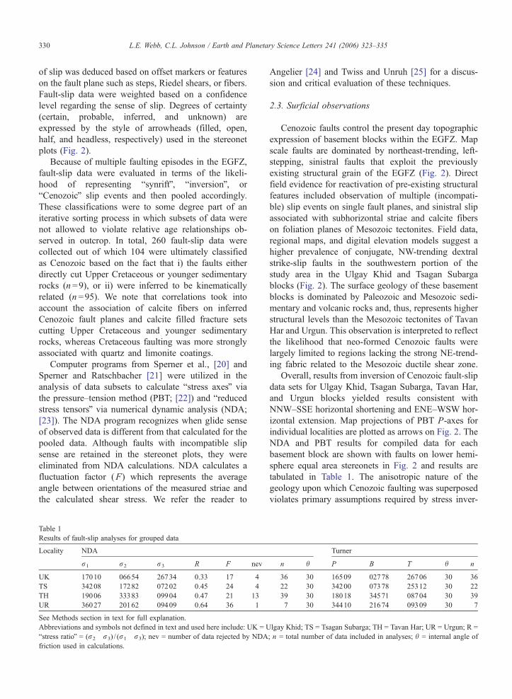
Computer programs from Sperner et al., [20] and
Sperner and Ratschbacher [21] were utilized in the
analysis of data subsets to calculate bstress axesQ via
the pressure–tension method (PBT; [22]) and breducedstress tensorsQ via numerical dynamic analysis (NDA;
[23]). The NDA program recognizes when glide sense
of observed data is different from that calculated for the
pooled data. Although faults with incompatible slip
sense are retained in the stereonet plots, they were
eliminated from NDA calculations. NDA calculates a
fluctuation factor (F) which represents the average
angle between orientations of the measured striae and
the calculated shear stress. We refer the reader to
Table 1
Results of fault-slip analyses for grouped data
Locality NDA
r1 r2 r3 R F nev
UK 17010 06654 26734 0.33 17 4
TS 34208 17282 07202 0.45 24 4
TH 19006 33383 09904 0.47 21 13
UR 36027 20162 09409 0.64 36 1
See Methods section in text for full explanation.
Abbreviations and symbols not defined in text and used here include: UK = U
bstress ratioQ = (r2�r3) / (r1�r3); nev = number of data rejected by NDA
friction used in calculations.
Angelier [24] and Twiss and Unruh [25] for a discus-
sion and critical evaluation of these techniques.
2.3. Surficial observations
Cenozoic faults control the present day topographic
expression of basement blocks within the EGFZ. Map
scale faults are dominated by northeast-trending, left-
stepping, sinistral faults that exploit the previously
existing structural grain of the EGFZ (Fig. 2). Direct
field evidence for reactivation of pre-existing structural
features included observation of multiple (incompati-
ble) slip events on single fault planes, and sinistral slip
associated with subhorizontal striae and calcite fibers
on foliation planes of Mesozoic tectonites. Field data,
regional maps, and digital elevation models suggest a
higher prevalence of conjugate, NW-trending dextral
strike-slip faults in the southwestern portion of the
study area in the Ulgay Khid and Tsagan Subarga
blocks (Fig. 2). The surface geology of these basement
blocks is dominated by Paleozoic and Mesozoic sedi-
mentary and volcanic rocks and, thus, represents higher
structural levels than the Mesozoic tectonites of Tavan
Har and Urgun. This observation is interpreted to reflect
the likelihood that neo-formed Cenozoic faults were
largely limited to regions lacking the strong NE-trend-
ing fabric related to the Mesozoic ductile shear zone.
Overall, results from inversion of Cenozoic fault-slip
data sets for Ulgay Khid, Tsagan Subarga, Tavan Har,
and Urgun blocks yielded results consistent with
NNW–SSE horizontal shortening and ENE–WSW hor-
izontal extension. Map projections of PBT P-axes for
individual localities are plotted as arrows on Fig. 2. The
NDA and PBT results for compiled data for each
basement block are shown with faults on lower hemi-
sphere equal area stereonets in Fig. 2 and results are
tabulated in Table 1. The anisotropic nature of the
geology upon which Cenozoic faulting was superposed
violates primary assumptions required by stress inver-
Turner
n h P B T h n
36 30 16509 02778 26706 30 36
22 30 34200 07378 25312 30 22
39 30 18018 34571 08704 30 39
7 30 34410 21674 09309 30 7
lgay Khid; TS = Tsagan Subarga; TH = Tavan Har; UR = Urgun; R =
; n = total number of data included in analyses; h = internal angle of
L.E. Webb, C.L. Johnson / Earth and Planetary Science Letters 241 (2006) 323–335 331
sions and therefore the results for the Cenozoic fault-
slip data sets are interpreted herein only in terms of
kinematics rather than paleostress in its strict dynamic
sense. There is reasonably good agreement, with a few
obvious exceptions, regarding the orientation of the
majority of PBT axes calculated for individual localities
as well as those indicated by PBT and NDA calcula-
tions for the bulk Cenozoic data sets from each base-
ment block. The calculated fluctuation factors (F)
range from 178 to 368, thereby implying heterogeneous
data sets (homogeneous fault populations will tend to
have an F value of V108; see Ratschbacher et al. [26]
and references therein). This result is not entirely un-
expected and may reflect local aberrations due to local
fault interactions as well as the preferential reactivation
of pre-existing structures. These data should not be
over-interpreted, but the consistency of results suggests
that they are meaningful with respect to the Cenozoic
kinematics of the fault zone.
Regional maps of Tavan Har divide the block into
two different basement types; the juxtaposition has
been interpreted as a Paleozoic terrane boundary
([27]; Fig. 4). Rocks of the northern half of Tavan
Har comprise mylonite, schist, gneiss, and synkine-
matic intrusives. Though mapped as part of the Pro-
terozoic dUlaan-UulT terrane [27], these rocks are in
fact metamorphic tectonites of the Late Triassic sinis-
tral shear zone. The southern half of Tavan Har has
been mapped as the dHovsgol-UlaanbadrahT terrane
and includes greenschist-grade Paleozoic sedimentary
rocks and intrusive complexes. These rocks also re-
cord evidence of Late Triassic sinistral shear just south
of the mapped terrane boundary [15]. Field mapping
reveals that the inferred terrane boundary is in fact one
of two major brittle sinistral strike-slip faults that
define the EGFZ at Tavan Har. The North Zuunbayan
fault was identified in the subsurface by Johnson [5]
and defines the northern topographic limit of the
Tavan Har block. The southern dterrane boundaryTfault zone consists of subparallel fault strands contin-
uous for more than 13 km (mapped length) that splay
to the east. Fault gouge, breccia, and slivers of Paleo-
zoic basement rocks are associated with fault strands
that define a zone 10s to 100s of meters wide. The
fault zone itself does not have a clear surface expres-
sion (i.e., modern fault scarp) except that resulting
from erosion (e.g., Fig. 5b).
Trenching along the southern fault strand revealed
clay and powder-sized fault gouge and breccia, in
multiple zones 1–10 m wide. These zones have
variable color (pink, gray, white, black), and common
white calcite veins. Most significantly, trenches reveal
faults with gouge that cross-cut and deform uncon-
solidated sediment (Fig. 5c), which includes poorly
sorted calcareous sand and gravel. An undisturbed
layer of unconsolidated sediment overlaps both the
gouge and deformed sediment zones. This unde-
formed layer forms the modern pavement surface of
rock-varnished gravel–cobble alluvium common to
the area.
Lithologies within the unconsolidated alluvium have
not yet yielded radiometric or spore/pollen dates. How-
ever, Upper and Lower Cretaceous strata are wide-
spread and well-studied in the region and, by
comparison, bear little resemblance to the units found
in the trenches. Upper Mesozoic strata in the region are
generally well-cemented and lithified due to burial of
up to 1–2 km, and include lacustrine shale and carbon-
ate, abundant volcanics, and alluvial–fluvial lithofacies
assemblages [4,28]. Alluvium found in the fault zone
lacks the distinctive red color of Upper Cretaceous
strata in much of the southeastern Mongolia, which
also tend to be better lithified than what is seen in the
fault zone. The unconsolidated sediment found within
the breccia and gouge zones therefore postdates the
Upper Cretaceous post-rift sequence, and is most likely
Cenozoic in age.
3. Discussion
Outcrop and subsurface data support a Cenozoic
phase of deformation in the EGFZ involving strike-
slip faulting. One previous study [9] cites post-Creta-
ceous dextral motion on northeast-trending faults in the
area. That interpretation, however, appears to be based
on limited, medium to low confidence data. Alterna-
tively, those observations may reflect a more recent and
limited phase of faulting (see discussion to follow). Our
fault-slip data from several basement block localities
within the EGFZ indicate, rather, that regional Ceno-
zoic faulting was dominated by sinistral strike-slip
faulting on northeast-trending structures. Conjugate
dextral faults appear to play only a minor role, possibly
due to the inherited NE-trending structural grain of the
EGFZ.
The fault-slip inversions yielded P-axes at higher
angles to the mapped faults than typically expected
for strike-slip fault systems. It is important to empha-
size that these faults did not form in response to an
imposed Cenozoic stress field but, rather, are reacti-
vated structures. While we do not interpret the inver-
sion data presented here to represent principal stress
directions, it is probably a fair assumption that if the
calculated shortening and extension axes for each of the
L.E. Webb, C.L. Johnson / Earth and Planetary Science Letters 241 (2006) 323–335332
grouped sets of fault-slip data and the majority of
individual localities are subhorizontal (Fig. 2), then r1
and r3 were likely subhorizontal as well. Thus, the
possibility exists that blocks within the EGFZ may
have experienced vertical axis rotations. With progres-
sive faulting, bP-axesQ (as recorded by the fault-slip
data) may have rotated counterclockwise to a higher-
angle orientation to the regional faults. Many of the
fault-slip data, however, do show a dip-slip component
and are consistent with an element of transpression
(Figs. 2 and 5a) and so r1 may also have been highly
oblique to the pre-existing structural trends within the
EGFZ.
3.1. Comparison with neotectonic framework
The apparent NNW-shortening and ENE-extension
directions implied by Cenozoic fault-slip data in the
study area are incompatible with most studies regarding
neotectonics of Asia (e.g., [29–31]). Inversions of Ce-
nozoic fault-slip data from the EGFZ yield axes nearly
orthogonal to those calculated by these studies. How-
ever, there is not complete agreement with respect to
the implications of geodetic data available for this
region. Calais and Amarjargal [32] and Calais et al.
[33] record the relative eastward motion of the Amur-
ian/North China block relative to stable Eurasia. These
data require the presence of left-lateral faulting to the
north of the study area, and this motion is likely taken
up by extension at Lake Baikal and the left-lateral
Stanovoy fault system that extends from its northern
end toward the Sea of Okhotsk [29,34,35]. Conversely,
Shen et al. [36] infer the presence of left-lateral faulting
along the northern rim of China based on GPS data that
show China to be moving eastward relative to bstableQMongolia. Although there are apparently conflicting
views as to whether the EGFZ should be included as
part of stable Eurasia or not, the data from Mongolia
seem to weigh more heavily in favor of its motion
relative to Eurasia [32,33].
Compiled twentieth century seismicity data for
Mongolia [37] reveal that the EGFZ is located in one
of the least seismically active areas of Mongolia. The
EGFZ region experienced several earthquakes of mag-
nitude 6.5 or below between 1900 and 2000, but earth-
quakes were sporadic and the region stands in stark
contrast to the western portion of the country where the
active faults are clearly defined by continuous cluster-
ing of earthquake epicenters. These data in conjunction
with our observations above lead us to propose a Ter-
tiary age for regional Cenozoic faulting in southeastern
Mongolia.
3.2. Tectonic implications
The recognition of Tertiary faulting along the EGFZ
has broad implications that extend well beyond the
regional geology. These results are relevant to models
regarding continental deformation associated with the
Indo-Asia collision as to whether convergence has been
accommodated by plane strain, plate-like deformation
resulting in extrusion of coherent lithospheric blocks
(e.g. [11]) versus continuum crustal thickening (e.g.,
[10]), or some combination of the two in which the
former transitions to the latter [38].
The Altyn Tagh fault (ATF; Fig. 1) is a topic of
ongoing debate. Some studies of offset of pre-Tertiary
geologic features have indicated a total displacement of
approximately 375 km on the ATF, largely in Oligo-
cene–Miocene time [39,40]. Yin et al. [41], however,
suggest 470 km of Cenozoic offset with strike-slip
faulting initiating at c. 49 Ma. Several authors have
proposed the extension of the ATF northeastward
through the EGFZ and beyond to the Sea of Okhotsk
(e.g., [35,38,42]). Others consider the fault to terminate
by linking with thrust faults in the region of the Qilian
Shan at the northern edge of the Tibetan Plateau (e.g.,
[41,43,44]). At the heart of this debate, in our opinion,
is not whether slip on the ATF is transferred to these
thrusts faults today, but the feasibility of the ATF
having once transferred left-lateral slip to faults north
of the Qilian Shan (i.e. having been kinematically
linked with the EGFZ). The possibility of the latter
requires first that the presence of a linking system of
faults between the present day northern termination of
the ATF and the EGFZ be identified. Secondly, it
requires that these faults have compatible history prior
to the onset of thrusting in the Qilian Shan, for which
estimates range from 20–10 Ma [45] to after 6–5 Ma
[46].
New observations from the Alxa fault zone area
document the presence of Cenozoic sinistral strike-
slip activity on roughly E–W trending faults, bridging
the gap between the ATF and the Mongolian border
(Fig. 1; [47]). These workers estimate post-Cretaceous
offsets in the range of tens of kilometers to greater than
150 km, noting limited Neogene displacement. Various
piercing points have been proposed for the Alxa–EGFZ
near the Mongolia–China border but as of yet have not
been rigorously tested. For example, Yue and Liou [38]
proposed some 400 km of left-lateral offset beginning
in the Late Oligocene (c.f. Yue et al. [48]). In contrast,
Lamb et al. [3] proposed 185–235 km of offset in
southeast Mongolia associated with Late Triassic sinis-
tral shear (e.g. A–AV and B–BW, Fig. 1b). In both cases,
L.E. Webb, C.L. Johnson / Earth and Planetary Science Letters 241 (2006) 323–335 333
these studies relied heavily on interpretations of region-
al maps but lacked complementary field campaigns.
Given the evidence for left-lateral offset in both the
Mesozoic and Cenozoic and the fact that offset was
based on displaced Paleozoic rocks, the proposed pierc-
ing points in both cases can only represent total offset.
Remote sensing data indicate that multiple fault
strands exist northeast of the Qilian Shan, suggesting
that Cenozoic slip may have been distributed over
several faults (Fig. 1b). We hypothesize that maximum
slip magnitude along the EGFZ in the Cenozoic may
have been as much as 150 km, similar to estimates for
the Alxa region by Darby et al. [47]. In both regions,
this magnitude is based on offset Early Cretaceous
sedimentary basins. Comparative field studies of synrift
strata at Tavan Har and Har Hotol support the inference
from seismic data (Fig. 4) that very different sequences
of Cretaceous and younger strata are juxtaposed by
some amount of movement postdating their deposition.
These observations include distinct sediment sources
and overall stratigraphic architecture for Lower Creta-
ceous strata [4], which at Har Hotol (Fig. 1b) include
distinctive red bed alluvial and fluvial units, basalt
flows and reworked ash deposits, and freshwater lacus-
trine units. In contrast, synrift strata at Tavan Har
include extensive and lithologically distinctive, organ-
ic-rich laminated mudstones locally termed dpapershales.T While facies transitions are common over rel-
atively short distances in nonmarine basins, our studies
indicate that some of these lake systems were long-
lived, widespread (e.g., N50 km) and stratified, and are
actually truncated by the EGFZ [49]. North of the fault
zone, the most likely lithologic match with paper shale
units from Tavan Har occurs near Ulgay Khid (Fig. 1b,
C–CV). Molecular organic geochemical studies also in-
dicate similarities between distinctive lacustrine units at
these localities [50]. Thus the sedimentary data would
suggest that ~100–150 km of slip can be attributed to
the Cenozoic deformation phase, pending further com-
parison of those units.
Field-based observations have thus been made
toward satisfying the minimal requirements to support
a Tertiary kinematic linkage between the ATF and
EGFZ noted above (this work and Darby et al. [47]).
These data potentially lend credence to the model of
Yue and Liou [38] proposing a two-stage history in
which sinistral faulting is transferred from the ATF to
the EGFZ and associated faults beginning in Late
Oligocene and transitions to thrusting in the Qilian
Shan between 16 and 13 Ma. The proposed switch
from transferred sinistral faulting (extrusion) to termi-
nation into thrust faults in the Qilian Shan (crustal
thickening) roughly coincides with the transition
along the northeastern Pacific margin from transten-
sional to transpressional tectonics believed to have
occurred in the Late Miocene [35,42]. This funda-
mental switch in the boundary conditions related to
the Pacific margin may explain why the EGFZ
appears to have become relatively inactive compared
to the Gobi Altai where faulting actively continues
today.
4. Conclusions
New field observations from southeastern Mongolia
testify to regional Cenozoic sinistral faulting on the NE-
trending EGFZ. This deformation was associated with
roughly NNW-shortening and ENE-extension. Lines of
evidence that lead to a conservative estimate of a Tertiary
age of faulting include interpreted seismic reflection data
that reveal that the mid-Cretaceous unconformity is de-
formed by strike-slip faults [5] and field observations of
strike-slip faults and fracture sets that cut Upper Creta-
ceous and Cenozoic strata but are overlapped by alluvial
sediments that form the desert pavement. Additionally,
seismicity maps argue against the presence of significant
Quaternary faulting within the EGFZ. Cenozoic sinistral
faulting along NE-trending structures in southeastern
Mongolia was likely driven by the Indo-Asian collision
and facilitated by Pacific margin transtension. A Middle
Miocene or older linkage between the ATF and EGFZ
appears increasingly feasible as more data become avail-
able. However, a rigorous campaign to constrain the
timing and displacement associated with the Cenozoic
EGFZ and related Asian faults is required to further
evaluate such models. Nonetheless, the reactivation his-
tory of the EGFZ strongly supports the notion that
inherited lithospheric structures are important in control-
ling the location and, thus, modes of intracontinental
deformation.
Acknowledgements
This research was supported by the American Chem-
ical Society, Petroleum Research Fund (grant 40193-G8
to C.L. Johnson) and benefited from National Science
Foundation funding (grants EAR 9614555 and EAR-IF
0130833). Initial discovery and trenching of Cenozoic
faults at Tavan Har took place during a field study
supported in part by the Keck Consortium in July,
2003. A. Bayasgalan, B. Bayanmonh, R.J. Carson, P.
Kast, N. Manchuk, K. Pogue, and other members of
that field party contributed significantly to the initial
studies of these structures in outcrop. M. Affolter con-
L.E. Webb, C.L. Johnson / Earth and Planetary Science Letters 241 (2006) 323–335334
tributed to field studies in 2004. C. Minjin, N. Man-
chuk, and G. Sersmaa provided logistical support dur-
ing 2004, as well as invaluable scientific guidance
regarding Paleozoic stratigraphy and regional geology.
We thank B. Darby, D. Cunningham, and an anony-
mous reviewer for comments that helped to improve the
manuscript.
References
[1] J. Amory, Permian Sedimentation and Tectonics of Southern
Mongolia, Stanford University, 1996.
[2] G. Badarch, W.D. Cunningham, B.F. Windley, A new terrane
subdivision for Mongolia; implications for the Phanerozoic
crustal growth of Central Asia, J. Asian Earth Sci. 21 (2002)
87–110.
[3] M.A. Lamb, A.D. Hanson, S.A. Graham, G. Badarch, L.E.
Webb, Left-lateral sense offset of upper Proterozoic to Paleozoic
features across the Gobi Onon, Tost, and Zuunbayan faults in
southern Mongolia and implications for other Central Asian
faults, Earth Planet. Sci. Lett. 173 (1999) 183–194.
[4] S.A. Graham, M.S. Hendrix, C.L. Johnson, D. Badamgarav, G.
Badarch, J. Amory, M. Porter, R. Barsbold, L.E. Webb, B.R.
Hacker, Sedimentary record and tectonic implications of late