109
Testbed-12 WPS ISO Data Quality Service Profile Engineering Report

Testbed-12 WPS ISO Data QualityService Profile Engineering Report

Table of Contents1. Introduction . . . . . . . . . . . . . . . . . . . . . . . . . . . . . . . . . . . . . . . . . . . . . . . . . . . . . . . . . . . . . . . . . . . . . . . . . . . . . 6
1.1. Scope . . . . . . . . . . . . . . . . . . . . . . . . . . . . . . . . . . . . . . . . . . . . . . . . . . . . . . . . . . . . . . . . . . . . . . . . . . . . . . . . 6
1.2. Document contributor contact points . . . . . . . . . . . . . . . . . . . . . . . . . . . . . . . . . . . . . . . . . . . . . . . . . . . 6
1.3. Future Work . . . . . . . . . . . . . . . . . . . . . . . . . . . . . . . . . . . . . . . . . . . . . . . . . . . . . . . . . . . . . . . . . . . . . . . . . 6
1.4. Foreword . . . . . . . . . . . . . . . . . . . . . . . . . . . . . . . . . . . . . . . . . . . . . . . . . . . . . . . . . . . . . . . . . . . . . . . . . . . . 6
2. References . . . . . . . . . . . . . . . . . . . . . . . . . . . . . . . . . . . . . . . . . . . . . . . . . . . . . . . . . . . . . . . . . . . . . . . . . . . . . . . 7
3. Terms and definitions . . . . . . . . . . . . . . . . . . . . . . . . . . . . . . . . . . . . . . . . . . . . . . . . . . . . . . . . . . . . . . . . . . . . . 8
3.1. data quality . . . . . . . . . . . . . . . . . . . . . . . . . . . . . . . . . . . . . . . . . . . . . . . . . . . . . . . . . . . . . . . . . . . . . . . . . . 8
3.2. positional accuracy . . . . . . . . . . . . . . . . . . . . . . . . . . . . . . . . . . . . . . . . . . . . . . . . . . . . . . . . . . . . . . . . . . . 8
3.3. lineage . . . . . . . . . . . . . . . . . . . . . . . . . . . . . . . . . . . . . . . . . . . . . . . . . . . . . . . . . . . . . . . . . . . . . . . . . . . . . . . 8
3.4. attribute accuracy . . . . . . . . . . . . . . . . . . . . . . . . . . . . . . . . . . . . . . . . . . . . . . . . . . . . . . . . . . . . . . . . . . . . 8
3.5. consistency. . . . . . . . . . . . . . . . . . . . . . . . . . . . . . . . . . . . . . . . . . . . . . . . . . . . . . . . . . . . . . . . . . . . . . . . . . . 8
3.6. completeness . . . . . . . . . . . . . . . . . . . . . . . . . . . . . . . . . . . . . . . . . . . . . . . . . . . . . . . . . . . . . . . . . . . . . . . . . 8
4. Conventions. . . . . . . . . . . . . . . . . . . . . . . . . . . . . . . . . . . . . . . . . . . . . . . . . . . . . . . . . . . . . . . . . . . . . . . . . . . . . . 9
4.1. Abbreviated terms . . . . . . . . . . . . . . . . . . . . . . . . . . . . . . . . . . . . . . . . . . . . . . . . . . . . . . . . . . . . . . . . . . . . 9
4.2. UML notation. . . . . . . . . . . . . . . . . . . . . . . . . . . . . . . . . . . . . . . . . . . . . . . . . . . . . . . . . . . . . . . . . . . . . . . . . 9
4.3. Used parts of other documents . . . . . . . . . . . . . . . . . . . . . . . . . . . . . . . . . . . . . . . . . . . . . . . . . . . . . . . . . 9
5. Overview . . . . . . . . . . . . . . . . . . . . . . . . . . . . . . . . . . . . . . . . . . . . . . . . . . . . . . . . . . . . . . . . . . . . . . . . . . . . . . . 10
6. Status Quo & New Requirements Statement . . . . . . . . . . . . . . . . . . . . . . . . . . . . . . . . . . . . . . . . . . . . . . . . 11
6.1. Status Quo . . . . . . . . . . . . . . . . . . . . . . . . . . . . . . . . . . . . . . . . . . . . . . . . . . . . . . . . . . . . . . . . . . . . . . . . . . 11
6.1.1. Data quality assurance and data quality control . . . . . . . . . . . . . . . . . . . . . . . . . . . . . . . . . . . . 11
6.1.2. Data quality assessment challenges . . . . . . . . . . . . . . . . . . . . . . . . . . . . . . . . . . . . . . . . . . . . . . . . 11
6.2. Requirements Statement . . . . . . . . . . . . . . . . . . . . . . . . . . . . . . . . . . . . . . . . . . . . . . . . . . . . . . . . . . . . . 12
7. Solutions . . . . . . . . . . . . . . . . . . . . . . . . . . . . . . . . . . . . . . . . . . . . . . . . . . . . . . . . . . . . . . . . . . . . . . . . . . . . . . . 13
7.1. Targeted Solutions . . . . . . . . . . . . . . . . . . . . . . . . . . . . . . . . . . . . . . . . . . . . . . . . . . . . . . . . . . . . . . . . . . . 13
7.1.1. Overall Design Strategy and Architecture . . . . . . . . . . . . . . . . . . . . . . . . . . . . . . . . . . . . . . . . . . 13
7.1.2. Completeness Omission/Completeness Commission . . . . . . . . . . . . . . . . . . . . . . . . . . . . . . . . . 14
7.1.3. Positional Accuracy . . . . . . . . . . . . . . . . . . . . . . . . . . . . . . . . . . . . . . . . . . . . . . . . . . . . . . . . . . . . . . 14
7.1.4. Topological Consistency . . . . . . . . . . . . . . . . . . . . . . . . . . . . . . . . . . . . . . . . . . . . . . . . . . . . . . . . . . 14
7.2. Recommendations . . . . . . . . . . . . . . . . . . . . . . . . . . . . . . . . . . . . . . . . . . . . . . . . . . . . . . . . . . . . . . . . . . . 14
7.2.1. Completeness Omission/Completeness Commission WPS processes . . . . . . . . . . . . . . . . . . . 15
7.2.2. Positional Accuracy WPS processes . . . . . . . . . . . . . . . . . . . . . . . . . . . . . . . . . . . . . . . . . . . . . . . . 20
7.2.3. Logical Consistency WPS processes . . . . . . . . . . . . . . . . . . . . . . . . . . . . . . . . . . . . . . . . . . . . . . . . 22
7.2.4. Thematic Consistency WPS process . . . . . . . . . . . . . . . . . . . . . . . . . . . . . . . . . . . . . . . . . . . . . . . . 26
8. Use Cases . . . . . . . . . . . . . . . . . . . . . . . . . . . . . . . . . . . . . . . . . . . . . . . . . . . . . . . . . . . . . . . . . . . . . . . . . . . . . . . 31
8.1. Use Case 1 - Completeness Omission/Completeness Commission . . . . . . . . . . . . . . . . . . . . . . . . . 31
8.1.1. Use Case 1.1 - Evaluate Data Quality on Completeness Omission . . . . . . . . . . . . . . . . . . . . . . 31
8.2. Use Case 2 - Positional Accuracy . . . . . . . . . . . . . . . . . . . . . . . . . . . . . . . . . . . . . . . . . . . . . . . . . . . . . . . 35

8.2.1. Use Case 2.1 - Positional Accuracy (vector feature) . . . . . . . . . . . . . . . . . . . . . . . . . . . . . . . . . . 35
8.2.2. Use Case 2.2 - Positional Accuracy (gridded) . . . . . . . . . . . . . . . . . . . . . . . . . . . . . . . . . . . . . . . . 38
8.3. Use Case 3 - Logical Accuracy . . . . . . . . . . . . . . . . . . . . . . . . . . . . . . . . . . . . . . . . . . . . . . . . . . . . . . . . . 39
8.3.1. Use Case 3.1 - Topological Consistency . . . . . . . . . . . . . . . . . . . . . . . . . . . . . . . . . . . . . . . . . . . . . 39
8.3.2. Use Case 3.2 - Conceptual Consistency . . . . . . . . . . . . . . . . . . . . . . . . . . . . . . . . . . . . . . . . . . . . . 40
8.3.3. Use Case 3.3 - Domain Consistency. . . . . . . . . . . . . . . . . . . . . . . . . . . . . . . . . . . . . . . . . . . . . . . . . 43
8.4. Use Case 4 - Thematic Accuracy . . . . . . . . . . . . . . . . . . . . . . . . . . . . . . . . . . . . . . . . . . . . . . . . . . . . . . . 44
8.4.1. Use Case 4.1 - Classification Correctness . . . . . . . . . . . . . . . . . . . . . . . . . . . . . . . . . . . . . . . . . . . . 44
8.4.2. Use Case 4.2 - Non-Quantitative Attribute Accuracy . . . . . . . . . . . . . . . . . . . . . . . . . . . . . . . . . 47
8.4.3. Use Case 4.3 - Quantitative Attribute Accuracy . . . . . . . . . . . . . . . . . . . . . . . . . . . . . . . . . . . . . . 48
9. Future Recommendations . . . . . . . . . . . . . . . . . . . . . . . . . . . . . . . . . . . . . . . . . . . . . . . . . . . . . . . . . . . . . . . . 51
9.1. Evolution of Data Quality Standards . . . . . . . . . . . . . . . . . . . . . . . . . . . . . . . . . . . . . . . . . . . . . . . . . . . 51
9.2. Data Quality Workflow . . . . . . . . . . . . . . . . . . . . . . . . . . . . . . . . . . . . . . . . . . . . . . . . . . . . . . . . . . . . . . . 51
9.3. Data Quality Test Suites . . . . . . . . . . . . . . . . . . . . . . . . . . . . . . . . . . . . . . . . . . . . . . . . . . . . . . . . . . . . . . 51
Appendix A: ISO Data Quality WPS Process Examples - Test examples for DQ Completeness
Omission/Completeness Commission
52
Appendix B: ISO Data Quality WPS Process Examples - Test examples for DQ Positional Accuracy 67
Appendix C: ISO Data Quality WPS Process Examples - Test examples for DQ Logical Accuracy . . . 72
Appendix D: ISO Data Quality WPS Process Examples - Test examples for DQ Thematic Accuracy . 83
Appendix E: Revision History . . . . . . . . . . . . . . . . . . . . . . . . . . . . . . . . . . . . . . . . . . . . . . . . . . . . . . . . . . . . . . 104
Appendix F: Bibliography . . . . . . . . . . . . . . . . . . . . . . . . . . . . . . . . . . . . . . . . . . . . . . . . . . . . . . . . . . . . . . . . . 106

Publication Date: 2017-06-30
Approval Date: 2017-01-26
Posted Date: 2016-11-11
Reference number of this document: OGC 16-041r1
Reference URL for this document: http://www.opengis.net/doc/PER/t12-A080
Category: Public Engineering Report
Editor: Liping Di, Eugene G. Yu, Md Shahinoor Rahman, Ranjay Shrestha
Title: Testbed-12 WPS ISO Data Quality Service Profile Engineering Report
Testbed-12 WPS ISO Data Quality Service Profile Engineering Report (16-041r1)
COPYRIGHT
Copyright © 2017 Open Geospatial Consortium. To obtain additional rights ofuse, visit http://www.opengeospatial.org/
WARNING
This document is an OGC Public Engineering Report created as a deliverable ofan initiative from the OGC Innovation Program (formerly OGC InteroperabilityProgram). It is not an OGC standard and not an official position of the OGCmembership.It is distributed for review and comment. It is subject to changewithout notice and may not be referred to as an OGC Standard. Further, anyOGC Engineering Report should not be referenced as required or mandatorytechnology in procurements. However, the discussions in this document couldvery well lead to the definition of an OGC Standard.
1

LICENSE AGREEMENT
Permission is hereby granted by the Open Geospatial Consortium, ("Licensor"),free of charge and subject to the terms set forth below, to any person obtaining acopy of this Intellectual Property and any associated documentation, to deal inthe Intellectual Property without restriction (except as set forth below),including without limitation the rights to implement, use, copy, modify, merge,publish, distribute, and/or sublicense copies of the Intellectual Property, and topermit persons to whom the Intellectual Property is furnished to do so, providedthat all copyright notices on the intellectual property are retained intact andthat each person to whom the Intellectual Property is furnished agrees to theterms of this Agreement.
If you modify the Intellectual Property, all copies of the modified IntellectualProperty must include, in addition to the above copyright notice, a notice thatthe Intellectual Property includes modifications that have not been approved oradopted by LICENSOR.
THIS LICENSE IS A COPYRIGHT LICENSE ONLY, AND DOES NOT CONVEY ANYRIGHTS UNDER ANY PATENTS THAT MAY BE IN FORCE ANYWHERE IN THEWORLD. THE INTELLECTUAL PROPERTY IS PROVIDED "AS IS", WITHOUTWARRANTY OF ANY KIND, EXPRESS OR IMPLIED, INCLUDING BUT NOTLIMITED TO THE WARRANTIES OF MERCHANTABILITY, FITNESS FOR APARTICULAR PURPOSE, AND NONINFRINGEMENT OF THIRD PARTY RIGHTS.THE COPYRIGHT HOLDER OR HOLDERS INCLUDED IN THIS NOTICE DO NOTWARRANT THAT THE FUNCTIONS CONTAINED IN THE INTELLECTUALPROPERTY WILL MEET YOUR REQUIREMENTS OR THAT THE OPERATION OFTHE INTELLECTUAL PROPERTY WILL BE UNINTERRUPTED OR ERROR FREE.ANY USE OF THE INTELLECTUAL PROPERTY SHALL BE MADE ENTIRELY ATTHE USER’S OWN RISK. IN NO EVENT SHALL THE COPYRIGHT HOLDER OR ANYCONTRIBUTOR OF INTELLECTUAL PROPERTY RIGHTS TO THE INTELLECTUALPROPERTY BE LIABLE FOR ANY CLAIM, OR ANY DIRECT, SPECIAL, INDIRECT ORCONSEQUENTIAL DAMAGES, OR ANY DAMAGES WHATSOEVER RESULTINGFROM ANY ALLEGED INFRINGEMENT OR ANY LOSS OF USE, DATA OR PROFITS,WHETHER IN AN ACTION OF CONTRACT, NEGLIGENCE OR UNDER ANY OTHERLEGAL THEORY, ARISING OUT OF OR IN CONNECTION WITH THEIMPLEMENTATION, USE, COMMERCIALIZATION OR PERFORMANCE OF THISINTELLECTUAL PROPERTY.
This license is effective until terminated. You may terminate it at any time by
2

destroying the Intellectual Property together with all copies in any form. Thelicense will also terminate if you fail to comply with any term or condition ofthis Agreement. Except as provided in the following sentence, no suchtermination of this license shall require the termination of any third party end-user sublicense to the Intellectual Property which is in force as of the date ofnotice of such termination. In addition, should the Intellectual Property, or theoperation of the Intellectual Property, infringe, or in LICENSOR’s sole opinion belikely to infringe, any patent, copyright, trademark or other right of a thirdparty, you agree that LICENSOR, in its sole discretion, may terminate this licensewithout any compensation or liability to you, your licensees or any other party.You agree upon termination of any kind to destroy or cause to be destroyed theIntellectual Property together with all copies in any form, whether held by youor by any third party.
Except as contained in this notice, the name of LICENSOR or of any other holderof a copyright in all or part of the Intellectual Property shall not be used inadvertising or otherwise to promote the sale, use or other dealings in thisIntellectual Property without prior written authorization of LICENSOR or suchcopyright holder. LICENSOR is and shall at all times be the sole entity that mayauthorize you or any third party to use certification marks, trademarks or otherspecial designations to indicate compliance with any LICENSOR standards orspecifications.
This Agreement is governed by the laws of the Commonwealth of Massachusetts.The application to this Agreement of the United Nations Convention onContracts for the International Sale of Goods is hereby expressly excluded. Inthe event any provision of this Agreement shall be deemed unenforceable, voidor invalid, such provision shall be modified so as to make it valid andenforceable, and as so modified the entire Agreement shall remain in full forceand effect. No decision, action or inaction by LICENSOR shall be construed to bea waiver of any rights or remedies available to it.
None of the Intellectual Property or underlying information or technology maybe downloaded or otherwise exported or reexported in violation of U.S. exportlaws and regulations. In addition, you are responsible for complying with anylocal laws in your jurisdiction which may impact your right to import, export oruse the Intellectual Property, and you represent that you have complied withany regulations or registration procedures required by applicable law to makethis license enforceable.
3

Abstract
This Data Quality Engineering Report describes data quality handlingrequirements, challenges and solutions. One focus is on data quality in generalthat needs to be communicated from one service to another. In addition, itdiscusses WPS data quality solutions. The ultimate goal is for it to be nominatedas a WPS ISO Data Quality Service Profile. ISO 19139 is used as the base toencode the data quality. WPS and workflows are used to streamline andstandardize the process of data quality assurance and quality control. The maintopics include: (1) generalized summary and description of the design and bestpractices for analyzing data quality of all feature data sources used in theCitizen Observatory WEB (COBWEB) project, (2) solutions and recommendationsfor enabling provenance of data quality transparent to end users when the datais processed through a WPS, (3) best practices and recommendations fordesigning and prototyping the WPS profile to support data quality serviceconformant to the NSG Metadata Framework, and (4) general solution for dataquality fit for both raster-based imageries and vector-based features.
Business Value
This Engineering Report (ER) captures the essence and best practice for dataquality that were successfully established and applied in the CitizenObservatory Web (COWBWEB) project. It goes one step further to formalize andstandardize the processes as OGC WPS processes to address data quality issuesby using networks of "people as sensors" and by analyzing observations andmeasurements in real-time combination with authoritative models and datasets.The ER content can be summarized as follows:
• Innovative use of crowdsourcing and citizen sensors to solve data qualitycontrol and assurance with prescribed seven standard WPS processes,
• Formalize the processes to solve data quality issues using citizen sensors thatharmonize the data and service interoperation across processes as Webservices, and
• Achieve compatible data quality assurance levels.
Technology Value
The relevance and importance of the ER to WPS 2.0 SWG are obvious in twoaspects. On the one hand, the best practice and solutions described in the ERutilizes WPS 2.0 as a general framework and service implementationspecification to achieve data quality control and assurance in dealing with
4

networks of citizen sensors and their information offers. Each data qualityoperation is implemented as WPS process. The adoption of WPS not onlybenefits high level interoperation among services, but also prompts theapplications of WPS in citizen sensor network applications. On the other hand,the formalization and standardization of seven processes identified in theCOBWEB project lead to the development of a WPS profile with ISO Data Qualitystandards that are applicable for citizen sensor data quality control andassurance. Seven processes are to be specified as WPS process. The seven WPSprocesses are: (1) LBS-Positioning, (2) Cleaning, (3) Automatic Validation, (4)Authoritative Data Comparison, (5) Model-Based Validation, (6) Linked DataAnalysis, and (7) Semantic Harmonization.
How does this ER relate to the work of the Working Group
This ER demonstrates a use case for web-based processing using the WPS 2.0interface standard. Also, a basis for a data quality WPS profile is described. Thegoal of the hierarchical profiling approach specified in the WPS 2.0 standard isto foster interoperability among different WPS clients and servers. A dataquality profile could serve as proof of concept of the WPS 2.0 profiling approachand could be used to incorporate data quality checks in (automated)geoprocessing workflows.
Keywords
ogcdocs, testbed-12, WPS, Web services, ISO 19139, ISO 19115, Workflow
Proposed OGC Working Group for Review and Approval
The ER will be submitted to WPS 2.0 SWG for review. The ultimate goal is todevelop and promote it as a WPS profile with the approval of WPS 2.0 SWG.
5

Chapter 1. Introduction
1.1. ScopeThis report captures the best practice of using WPS processes as the interoperation framework tosupport data quality assurance and control using networks of "people as sensors". Seven processesfor data quality control shall be formalized and specified as WPS processes. The interoperationamong processes as well as between citizen sensors shall be enabled at levels of data and services.
1.2. Document contributor contact pointsAll questions regarding this document should be directed to the editor or the contributors:
Table 1.1. Contacts
Name Organization
Eugene G. Yu George Mason University/CSISS
Liping Di George Mason University/CSISS
Md Shahinoor Rahman George Mason University/CSISS
Ranjay Shrestha George Mason University/CSISS
Lingjun Kang George Mason University/CSISS
Sam Meek Helyx Secure Information Systems Ltd
1.3. Future WorkSeveral future recommendations have been identified. Details will be discussed in the section onFuture Recommendations. The recommendations are: (1) alignment with the evolution ofgeospatial standards, (2) data quality workflow enablement, and (3) data quality service test suites.
1.4. ForewordAttention is drawn to the possibility that some of the elements of this document may be the subjectof patent rights. The Open Geospatial Consortium shall not be held responsible for identifying anyor all such patent rights.
Recipients of this document are requested to submit, with their comments, notification of anyrelevant patent claims or other intellectual property rights of which they may be aware that mightbe infringed by any implementation of the standard set forth in this document, and to providesupporting documentation.
6

Chapter 2. ReferencesThe following documents are referenced in this document. For dated references, subsequentamendments to, or revisions of, any of these publications do not apply. For undated references, thelatest edition of the normative document referred to applies.
• OGC 06-121r9, OGC® Web Services Common Standard
NOTEThis OWS Common Standard contains a list of normative references that are alsoapplicable to this Implementation Standard.
• OGC 14-065, OGC® WPS 2.0 Interface Standard
• OGC 06-121r9, OGC® Web Services Common Standard
• ISO 19157:2013, Geographic information — Data quality
• ISO/DTS 19157-2, Geographic information — Data quality — Part 2: XML SchemaImplementation
• ISO 19115:2003, Geographic information — Metadata
7

Chapter 3. Terms and definitionsFor the purposes of this report, the definitions specified in Clause 4 of the OWS CommonImplementation Standard [OGC 06-121r9] and in OGC® Abstract Specification Topic 11: Metadata[OGC 01-111] shall apply. In addition, the following terms and definitions apply.
3.1. data quality
Data quality is a concept used in the context to represent the geospatial data qualitywith multiple components that include data validity, precision and accuracy. Datavalidity may be described as “fitness for use,” i.e. the degree to which data are fitfor an application. Geospatial precision is related to resolution and variation.Geospatial accuracy refers only to how close the measurement is to the true value.
3.2. positional accuracy
the quantifiable value that represents the positional difference between twogeospatial layers or between a geospatial layer and reality
3.3. lineage
description of the history of the spatial data, including descriptions of the sourcematerial from which the data were derived, and the methods of derivation
3.4. attribute accuracy
the accuracy of the quantitative and qualitative information attached to each feature
3.5. consistency
description of the dependability of relationships encoded in the data structure of thedigital spatial data
3.6. completeness
the degree to which geographic features, their attributes and their relationships areincluded or omitted in a dataset
8

Chapter 4. Conventions
4.1. Abbreviated terms• APIApplication Program Interface
• BPMN Business Process Model and Notation
• COBWEB Citizen OBservatory WEB
• COMComponent Object Model
• CORBACommon Object Request Broker Architecture
• COTSCommercial Off The Shelf
• DCEDistributed Computing Environment
• DCOMDistributed Component Object Model
• DQ Data Quality
• DTS Draft Technical Specification
• GeoJSON Geographic JavaScript Object Notation
• GML Geography Markup Language
• IDLInterface Definition Language
• ISO International Organization for Standardization
• JSON JavaScript Object Notation
• NGA National Geospatial-Intelligence Agency
• NSG National System for Geospatial Intelligence
• UC Use Case
• WFS Web Feature Service
• WPS Web Processing Service
• XML EXtensible Markup Language
4.2. UML notationMost diagrams that appear in this standard are presented using the Unified Modeling Language(UML) static structure diagram, as described in Subclause 5.2 of [OGC 06-121r9].
4.3. Used parts of other documentsThis document uses significant parts of document [OGC 06-121r9]. To reduce the need to refer tothat document, this document copies some of those parts with small modifications. To indicatethose parts to readers of this document, the largely copied parts are shown with a light greybackground (15%).
9

Chapter 5. OverviewData quality services are the focus. Specifications and standards define how data quality isdescribed and presented. Many processes to derive data quality share common solutions fordifferent cases. This Engineering Report (ER) aims to enable automation of commonly requireddata quality measurements and assessments. Web Processing Service (WPS) is used as the vehicle toachieve such automation.
10

Chapter 6. Status Quo & New RequirementsStatement
6.1. Status Quo
6.1.1. Data quality assurance and data quality control
The Citizen Observatory Web (COBWEB) is a citizen science project that explores the potential ofcombining citizen resources and open geospatial standards in supporting biosphere data collection,validation, and analysis[1]. The infrastructure sets a suite of technologies to form a citizens’observatory framework that effectively exploits technological developments in ubiquitous mobiledevices, crowd-sourcing of geographic information and the operational applications of standardsbased spatial data infrastructure (SDI). The framework enables citizens to collect environmentalinformation on a range of parameters including species distribution, flooding and land cover/use[1,2]. Workflow was used to design different complex process from component services[3]. Dealingwith diversified sources of data, the project had to tackle the data quality issues. One of theimportant and efficient approaches is its adoption of WPS processes to enable data qualityassurance and validation. The data quality was addressed by using networks of “people as sensors”and by analyzing observations and measurements in real-time combination with authoritativemodels and datasets. The COBWEB project represents the status quo or starting point for the workdone in testbed 12 to develop and formalize the WPS processes to facilitate data quality assurance.
6.1.2. Data quality assessment challenges
In the COBWEB project, the challenges of the quality assurance were: how to design and implementa system that was flexible enough to qualify data with different fitness for purpose requirements,different data schemas, recorded by different devices. More specifically, the challenges are asfollows.
1. Fitness of data quality model: What to model? What is the proper model process? What are thevariations in capture devices/persons?
2. Provenance: The history of data collection is important. It is related to what curation process isinvolved.
3. Metaquality: The questions for different data qualities need to be answered. What are thequalities of DQ metadata? How to define accuracy? How to define completeness? What criteriaand strategies should be used to keep consistency?
4. Levels of DQ assessment: DQ assessment can be done at different levels. What should be theproper level? Is it needed to be as detailed as up to the level of dataset? Is it only necessary toevaluate at the level of collection?
5. Propagation of data uncertainty: Data error and uncertainty may be propagated through thechain of processes when multiple processes are involved. How to represent and record thepropagation among workflows? How to track the propagation among data fusion?
11

6.2. Requirements StatementThe requirements for the sponsor, NGA, differ from the COBWEB project in the following ways:
• The data is authoritative.
• The data is likely to have a static structure.
• Metadata is likely to exist for the products, which can be utilized in the qualification process.
• In COBWEB the focus was on observations recorded as points, this project requires qualificationto be performed on different types of data including points, lines, polygons and images.
By analyzing the requirements and the demand on data quality services, the following commonrequirements can be identified:
1. Quality assurance of data quality: This defines what to be assessed, how to assess, and requiredstandard approach.
2. Fit data quality assessment approaches: The atomic process may be represented as a WPSprocess. The complex assessment process may be combining or chaining several atomicprocesses to form workflows. Enabling workflows and composition of atomic processes allowsextended adaptivity and flexibility to meet various requirements with different complex levels.Efficiency can be achieved with enhanced reusability of atomic processes.
3. Provenance: This keeps track of data quality and data history.
4. Unified aggregating data quality to high levels: Approaches and methods to aggregate dataquality need to be unified.
5. Standard mechanisms to encode, store, and retrieve data quality metadata at multiple levels:Different levels of details on data may adopt different encoding, storing, and accessingmechanism. Geospatial data may be dealt with two levels in general: dataset and data collection.
6. Data quality consumption: Processes and outputs for data quality should be clearly understoodabout who is the intended consumer of recorded DQ information. Typical, two distinguishabletypes of consumption should be considered: machine-readable and human-readable.
There are also extra requirements from the sponsor including adherence to specific standards fordata and metadata. The main required standard is the NGA Metadata Framework and ISO 19115metadata documents. Recently, the quality elements of ISO 19115 have been split into a separatedocument, ISO 19157. It is going to be adopted as the document recording the quality elements asthe specifications from OGC and NGA evolve. In this testbed, all these will be taken into account indesigning the WPS Data Quality processes.
12

Chapter 7. Solutions
7.1. Targeted Solutions
7.1.1. Overall Design Strategy and Architecture
Data quality (DQ) involves different aspects – completeness, positional accuracy, topologicalaccuracy, domain consistency, conceptual consistency, format consistency, and correctness. Therealization of such DQ functionality is recommended to be implemented as a series of atomic WPSprocess. WPS, as an OGC processing specification, is identified as a fit technology to enable theimplementation of DQ processes in the Web environment[1, 2]. With considerations of dealing withcomplexity and multi-levels of granularity, each WPS process should be designed as atomic aspossible to allow its reusability in composition through workflows.
As defined in ISO 19157, there are many DQ criteria tests. The DQ WPS should consist of a set ofatomic DQ WPS test processes to meet the functional requirements defined in ISO 19157. Each DQprocess should be configurable and atomic. They should be passed with metrics that correspond tothe Universe of Discourse, or what the thresholds are for what is considered as quality in ISO 19157terms. The WPS processes all follow a similar design to make them interoperable, suited forchaining and so that they conform to some uniform pattern. This is depicted in the followingFigure.
Figure 1. Atomic DQ WPS process
Each atomic DQ WPS process may take two types of inputs: data and reference data. Both data andreference data can be served through standard WCS or WFS services. They can be encoded in GML,GeoJSON, XML, or JSON. An atomic DQ WPS process may output metadata in XML and/or optionallynon-conforming data in GML. The output should contain a statement to clarify its conformance.
There are three main aspects of data quality issues to be tested with DQ WPS processes. They are asfollows.
13

1. Data Quality Assurance/Quantity Control WPS,
2. Encoding/curating data quality: correctness, completeness, consistency, and provenance, and
3. Standard data quality metadata consumption: making mapping to NSG metadata frameworkmandatory, and providing both machine-readable and human-readable formats.
7.1.2. Completeness Omission/Completeness Commission
Completeness has two connotations. One is to inspect omission, i.e. how much is not included in thegeospatial database. Another is to inspect commission, i.e. how much is falsely included in thegeospatial database. The measurements can be in quantity, rate, or duplicates. This can beimplemented as one WPS process that completes the computation by comparing the geospatialdatabase with the reference geospatial database.
7.1.3. Positional Accuracy
The position accuracy is related to the geometrical measurements. There are two cases that havequite distinguishing characteristics due to their different formats – vector or raster. Two separateprocesses are proposed to deal with such different geospatial databases.
Positional Accuracy (vector feature)
Vector-based geospatial features are often managed by database or database-like system. Eachfeature has a set of attributes. There would be one or more fields that form the primary key. Byassociating the database to the reference databases, one can verify if they have the requiredpositional accuracy. This will be designed as a dedicated WPS process.
Positional Accuracy (gridded)
Raster-based geospatial features are concerned with spatial resolution and location displacement.The comparison and validation against reference raster-based dataset need to consider both spatialresolution and location displacement. This will be developed as one dedicated WPS process to checkpositional accuracy using a reference dataset.
7.1.4. Topological Consistency
Geometrical contradictions should not exist in the result geospatial database. This needs to verifythat geospatial rules are met, such as one location for one point, polygon bound by lines, etc. A WPSprocess will be designed and developed to complete the consistency check in a single geospatialdatabase.
7.2. RecommendationsISO standards will be adopted to encode data quality. Specifically, ISO 19157 is one of the primarystandards to support different aspects of data quality. The mapping of elements can be seen in thefollowing table.
14

Figure 7.2. ISO 19157 Element Map
In overall design, the following are recommended in dealing with data quality issues.
1. WPS workflow enablement with BPMN for flexibility
2. Seven important aspects for data quality control: location-based-service position correction,cleaning, model-based validation, authoritative data comparison, automatic validation, linkeddata analysis, and semantic harmonization (Meek, S Jackson, M Leibovici, DG (2014) )
3. Recommended levels of data quality metadata: multiple levels of conformance to meet differentrequirements and standard information to make users aware of levels of data quality assuranceand data quality control.
7.2.1. Completeness Omission/Completeness Commission WPS processes
The following table defines the generic WPS process for processing the CompletenessOmission/Completeness Commission. There are two types: omission and commission. The processescan be further broken down to different processes for vector-based and raster-based features.
Table 7.1. Completeness WPS Process
Name: iso19157.DQ_Completeness.DQ_Completeness
Description: 1. Calculate omission and commission of a dataset based on a referencedataset. 2. Calculate rate of omission and commission of a dataset based on areference dataset. 3. Calculate duplicate features within a dataset vector-based and raster-based features.
Input: Target dataset, field of interest, Reference dataset, field of interest declaration.
15

Algorithm: 1. Summarizes the data in each and calculates entry type and frequency forboth datasets and compares the results. 2. Uses the summary table calculatedin 1) and calculates a percentage of omission/commission. 3. Performs a multi-step check on the dataset. Compares geometries of a feature to all otherfeatures, if geometries match then compare each of the fields within thedataset, if the values all match then the entry is a duplicate.
Output: One of the following: 1. A table listing all data types and frequency for bothtarget and reference datasets. 2. A list of data types and rate ofomission/commission 3. The number of duplicate features.
Completeness Omission WPS processes
This section describes completeness omission WPS processes.
Completeness Omission WPS process for vector-based dataset
The following table defines the WPS process to evaluate the Completeness Omission of vector-baseddataset.
Table 7.2. Completeness Omission WPS Process for vector-based dataset
Name: iso19157.DQ_Completeness.DQ_CompletenessOmission
Description: 1. Calculate omission of a vector dataset based on a reference vector dataset. 2.Calculate rate of omission of a vector dataset based on a reference vectordataset. 3. Calculate duplicated features within a vector dataset.
Input: 1. Target vector dataset to be qualified 2. Reference vector dataset to qualifythe target vector dataset against 3. Lookup field for the target vector dataset 4.Lookup field for the reference vector dataset 5. Link to metadata document(optional) 6. Threshold for omission rate (percentage)
Algorithm: 1. Summarizes the data in each and calculates entry type and frequency forboth datasets and compares the results. 2. Uses the summary table calculatedin 1) and calculates a percentage of omission. 3. Performs a multi-step checkon the dataset. Compares geometries of a feature to all other features, ifgeometries match then compare each of the fields within the dataset, if thevalues all match then the entry is a duplicate.
Output: One of the following: 1. A table listing all data types and frequency for bothtarget and reference datasets. 2. A list of data types and rate of omission 3. Thenumber of duplicate features.
UML: See Figure 7.3.
Example: Endpoint: http://54.201.124.35/wps/WebProcessingService Request: Seeexample shown in Table A.1. in Appendix A. Response: See example responseshown in Table A.1. in Appendix A.
16
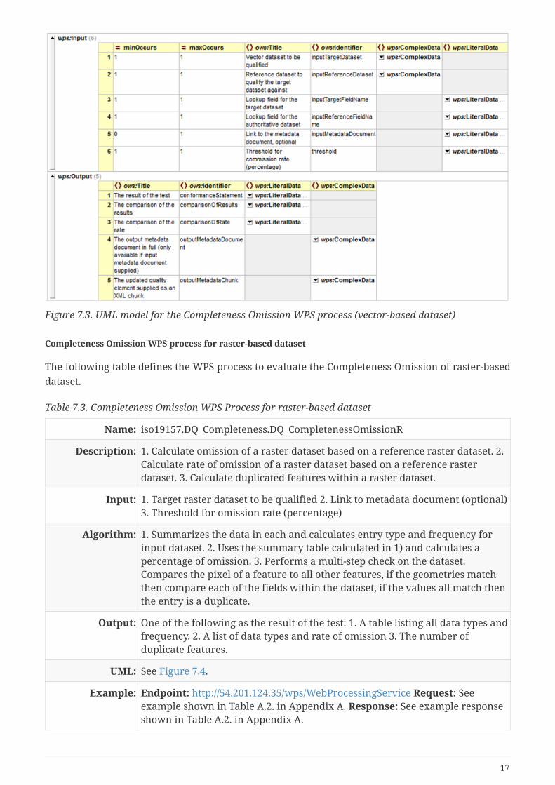
Figure 7.3. UML model for the Completeness Omission WPS process (vector-based dataset)
Completeness Omission WPS process for raster-based dataset
The following table defines the WPS process to evaluate the Completeness Omission of raster-baseddataset.
Table 7.3. Completeness Omission WPS Process for raster-based dataset
Name: iso19157.DQ_Completeness.DQ_CompletenessOmissionR
Description: 1. Calculate omission of a raster dataset based on a reference raster dataset. 2.Calculate rate of omission of a raster dataset based on a reference rasterdataset. 3. Calculate duplicated features within a raster dataset.
Input: 1. Target raster dataset to be qualified 2. Link to metadata document (optional)3. Threshold for omission rate (percentage)
Algorithm: 1. Summarizes the data in each and calculates entry type and frequency forinput dataset. 2. Uses the summary table calculated in 1) and calculates apercentage of omission. 3. Performs a multi-step check on the dataset.Compares the pixel of a feature to all other features, if the geometries matchthen compare each of the fields within the dataset, if the values all match thenthe entry is a duplicate.
Output: One of the following as the result of the test: 1. A table listing all data types andfrequency. 2. A list of data types and rate of omission 3. The number ofduplicate features.
UML: See Figure 7.4.
Example: Endpoint: http://54.201.124.35/wps/WebProcessingService Request: Seeexample shown in Table A.2. in Appendix A. Response: See example responseshown in Table A.2. in Appendix A.
17

Figure 7.4. UML model for the Completeness Omission WPS process (raster-based dataset)
Completeness Commission WPS processes
This section describes completeness commission WPS processes.
Completeness Commission WPS process for vector-based dataset
The following table defines the WPS process to evaluate the Completeness Commission of vector-based dataset.
Table 7.4. Completeness Commission WPS Process for vector-based dataset
Name: iso19157.DQ_Completeness.DQ_CompletenessCommission
Description: 1. Calculate commission of a vector dataset based on a reference vectordataset. 2. Calculate rate of commission of a vector dataset based on areference vector dataset. 3. Calculate duplicated features within a vectordataset.
Input: 1. Target vector dataset to be qualified 2. Reference vector dataset to qualifythe target vector dataset against 3. Lookup field for the target vector dataset 4.Lookup field for the reference vector dataset 5. Link to metadata document(optional) 6. Threshold for omission rate (percentage)
Algorithm: 1. Summarizes the data in each and calculates entry type and frequency forboth datasets and compares the results. 2. Uses the summary table calculatedin 1) and calculates a percentage of omission. 3. Performs a multi-step checkon the dataset. Compares geometries of a feature to all other features, ifgeometries match then compare each of the fields within the dataset, if thevalues all match then the entry is a duplicate.
Output: One of the following: 1. A table listing all data types and frequency for bothtarget and reference datasets. 2. A list of data types and rate of commission 3.The number of duplicate features.
UML: See Figure 7.5.
Example: Endpoint: http://54.201.124.35/wps/WebProcessingService Request: Seeexample shown in Table A.3. in Appendix A. Response: See example responseshown in Table A.3. in Appendix A.
18

Figure 7.5. UML model for the Completeness Commission WPS process (vector-based dataset)
Completeness Commission WPS process for raster-based dataset
The following table defines the WPS process to evaluate the Completeness Commission of raster-based dataset.
Table 7.5. Completeness Commission WPS Process for raster-based dataset
Name: iso19157.DQ_Completeness.DQ_CompletenessCOmmissionR
Description: 1. Calculate commission of a raster dataset based on a reference raster dataset.2. Calculate rate of commission of a raster dataset based on a reference rasterdataset. 3. Calculate duplicated features within a raster dataset.
Input: 1. Target raster dataset to be qualified 2. Link to metadata document (optional)3. Threshold for commission rate (percentage)
Algorithm: 1. Summarizes the data in each and calculates entry type and frequency forinput dataset. 2. Uses the summary table calculated in 1) and calculates apercentage of omission. 3. Performs a multi-step check on the dataset.Compares the pixel of a feature to all other features, if the geometries matchthen compare each of the fields within the dataset, if the values all match thenthe entry is a duplicate.
Output: One of the following as the result of the test: 1. A table listing all data types andfrequency. 2. A list of data types and rate of commission 3. The number ofduplicate features.
UML: See Figure 7.6.
Example: Endpoint: http://54.201.124.35/wps/WebProcessingService Request: Seeexample shown in Table A.4. in Appendix A. Response: See example responseshown in Table A.4. in Appendix A.
19

Figure 7.6. UML model for the Completeness Commission WPS process (raster-based dataset)
7.2.2. Positional Accuracy WPS processes
This section describes positional accuracy WPS processes.
Positional Accuracy (vector feature) WPS process
The following table defines the Positional Accuracy (vector feature) WPS processes.
Table 7.6. Positional Accuracy (vector feature) WPS processes
Name: iso19157.DQ_PositionalAccuracy.DQ_AbsoluteExternalPositionalAccuracy
Description: Calculates the positional accuracy of a target dataset given a reference datasetand lookup field
Input: Target dataset, target dataset field ID, reference dataset, reference dataset fieldID
Algorithm: It takes the target dataset and matches up its entries with those in thereference dataset by comparing their Identifiers (IDs) (they must be identifiedas an integer) - i.e. target dataset field ID and reference dataset field ID definedin the inputs.
Output: The mean uncertainties as defined by ISO 19157
UML: See Figure 7.7.
Example: Endpoint: http://54.201.124.35/wps/WebProcessingService Request: Seeexample shown in Table B.1. in Appendix B. Response: See example responseshown in Table B.1. in Appendix B.
20

Figure 7.7. UML model for the Positional Accuracy WPS process (vector-based dataset)
Positional Accuracy (gridded) WPS process
The following table defines the Positional Accuracy (gridded) WPS processes.
Table 7.7. Positional Accuracy (gridded) WPS processes
Name: iso19157.DQ_PositionalAccuracy.DQ_GriddedDataPositionalAccuracy
Description: Calculates the positional accuracy of a raster dataset based upon edges ofbuildings matched to a vector reference dataset.
Input: A georeferenced raster dataset as a GeoTIFF, set of reference polygons,threshold for edge detect (0-255), area for noise removal (very small areapolygons usually removed as they constitute noise).
Algorithm: The process does the following: •Histogram stretch •Laplace filter •Blackand White conversion •Black and white binary image creation •Black andwhite binary to polygons •Polygon distance to nearest reference polygon.
Output: The mean distance uncertainty as defined by ISO 19157, the Laplace image, thegenerated polygons.
UML: See Figure 7.8.
Example: Endpoint: http://54.201.124.35/wps/WebProcessingService Request: Seeexample shown in Table B.2. in Appendix B. Response: See example responseshown in Table B.2. in Appendix B.
21

Figure 7.8. UML model for the Positional Accuracy WPS process (raster-based dataset)
7.2.3. Logical Consistency WPS processes
This section describes logical consistency WPS processes.
Topological Consistency WPS process
The following table defines the Topological Consistency WPS processes.
Table 7.8. Topological Consistency WPS processes (vector features)
Name: iso19157.DQ_LogicalConsistency.DQ_TopolgicalConsistency
Description: Calculates and reports on potential topological issues inside a single dataset.
Input: Target dataset.
Algorithm: For line data, check the number of dangles. For polygon data, check thenumber of overlaps. When an optional parameter for buffer distance ortolerance is entered, polygon overlap or line dangle should be determined asthose over such given distance and the threshold would be evaluated as thepercentage of failures.
Output: Number of overlapping polygons equals 2.
UML: See Figure 7.9.
Example: Endpoint: http://54.201.124.35/wps/WebProcessingService Request: Seeexample shown in Table C.1. in Appendix C. Response: See example responseshown in Table C.1. in Appendix C.
22

Figure 7.9. UML model for the Topological Consistency WPS process (vector-based dataset)
Conceptual Consistency WPS process
The following table defines the generic Conceptual Consistency WPS processes.
Table 7.9. Conceptual Consistency WPS processes
Name: iso19157.DQ_LogicalConsistency.DQ_ConceptualConsistency
Description: Compares the input dataset with the conceptual schema.
Input: input image, metadata link, conceptual schema.
Algorithm: Dependent on the conceptual schema, it will involve a comparison betweenthe target dataset and the schema depending on how it is expressed.
Output: Updated metadata, conformance statement
Conceptual Consistency WPS process (vector features)
The following table defines the Conceptual Consistency WPS processes for vector dataset.
Table 7.10. Conceptual Consistency WPS processes (vector features)
Name: iso19157.DQ_LogicalConsistency.DQ_ConceptualConsistency
Description: Compares the input dataset with the conceptual schema.
Input: input image, metadata link, conceptual schema.
Algorithm: Dependent on the conceptual schema, it will involve a comparison betweenthe target dataset and the schema depending on how it is expressed.
Output: Updated metadata, conformance statement
UML: See Figure 7.10.
Example: Endpoint: http://54.201.124.35/wps/WebProcessingService Request: Seeexample shown in Table C.2. in Appendix C. Response: See example responseshown in Table C.2. in Appendix C.
23

Figure 7.10. UML model for the Conceptual Consistency WPS process (vector-based dataset)
Conceptual Consistency WPS process (raster dataset)
The following table defines the Conceptual Consistency WPS processes for raster dataset.
Table 7.11. Conceptual Consistency WPS processes (raster dataset)
Name: iso19157.DQ_LogicalConsistency.DQ_ConceptualConsistencyR
Description: Compares the input dataset with the conceptual schema.
Input: input image, metadata link, conceptual schema.
Algorithm: Dependent on the conceptual schema, it will involve a comparison betweenthe target dataset and the schema depending on how it is expressed.
Output: Updated metadata, conformance statement
UML: See Figure 7.11.
Example: Endpoint: http://54.201.124.35/wps/WebProcessingService Request: Seeexample shown in Table C.3. in Appendix C. Response: See example responseshown in Table C.3. in Appendix C.
24

Figure 7.11. UML model for the Conceptual Consistency WPS process (raster-based dataset)
Domain Consistency WPS process
The following table defines the Domain Consistency WPS processes.
Table 7.12. Domain Consistency WPS processes
Name: iso19157.DQ_LogicalConsistency.DQ_DomainConsistency
Description: Calculate and reports on a quantitative data field based on bounds.
Input: Target dataset, field name, minimum bound, maximum bound, metadatadocument link.
Algorithm: For numerical data only, check each record in a field for conformance to thebounds.
Output: The nonconforming features, a statement of the domain consistency, themetadata document with the updated Domain Consistency field.
UML: See Figure 7.12.
Example: Endpoint: http://54.201.124.35/wps/WebProcessingService Request: Seeexample shown in Table C.4. in Appendix C. Response: See example responseshown in Table C.4. in Appendix C.
25

Figure 7.12. UML model for the Domain Consistency WPS process (vector-based dataset)
7.2.4. Thematic Consistency WPS process
This section describes thematic consistency WPS processes.
Classification Correctness WPS process
The following table defines the Classification Correctness WPS processes.
Table 7.13. Classification Correctness WPS processes
Name: iso19157.DQ_ThematicAccuracy.DQ_ThematicClassificationCorrectness
Description: This process is for domain classified raster datasets that have been generatedfrom imagery. For example, soil, land use, agricultural datasets.
Input: input GeoTiff, input reference data (polygon) metadata link.
Algorithm: Check classifications against the universe of discourse provided by an input.Checks each pixel against the corresponding polygon for correctness.
Output: Updated metadata, conformance statement.
Classification Correctness WPS process (vector features)
The following table defines the Classification Correctness WPS processes for vector features.
Table 7.14. Classification Correctness WPS processes (vector features)
Name: iso19157.DQ_ThematicAccuracy.DQ_ThematicClassificationCorrectness
26

Description: This process is for domain classified raster datasets that have been generatedfrom imagery. For example, soil, land use, agricultural datasets.
Input: input target data (raster) in GeoTiff, input reference data (polygon) metadatalink..
Algorithm: Check classifications against the universe of discourse provided by an input.Checks each pixel against the corresponding polygon for correctness.
Output: Updated metadata, conformance statement.
UML: See Figure 7.13.
Example: Endpoint: http://54.201.124.35/wps/WebProcessingService Request: Seeexample shown in Table D.1. in Appendix D. Response: See example responseshown in Table D.1. in Appendix D.
Figure 7.13. UML model for the Classification Correctness WPS process (vector-based dataset)
Classification Correctness WPS process (raster dataset)
The following table defines the Classification Correctness WPS processes for raster dataset.
Table 7.15. Classification Correctness WPS processes (raster dataset)
Name: iso19157.DQ_ThematicAccuracy.DQ_ThematicClassificationCorrectnessR
Description: This process is for classified raster datasets that have been generated fromimagery. For example, soil, land use, agricultural datasets.
Input: input GeoTiff, input reference data (polygon) metadata link..
27

Algorithm: Check classifications against the universe of discourse provided by an input.Checks each pixel against the corresponding polygon for correctness.
Output: Updated metadata, conformance statement.
UML: See Figure 7.14.
Example: Endpoint: http://54.201.124.35/wps/WebProcessingService Request: Seeexample shown in Table D.2. in Appendix D. Response: See example responseshown in Table D.2. in Appendix D.
Figure 7.14. UML model for the Classification Correctness WPS process (raster-based dataset)
Non-Quantitative Attribute Accuracy WPS process
The following table defines the Non-Quantitative Attribute Accuracy WPS processes.
Table 7.16. Non-Quantitative Attribute Accuracy WPS processes
Name: iso19157.DQ_ThematicAccuracy.DQ_NonQuantitativeAttributeAccuracy
Description: Check non-quantitative attribute consistency.
Input: target dataset, the dataset to be be used as an authoritative source, the fieldthat holds the non-quantitative values in the target dataset, the field that holdsthe values in the reference dataset, a link to the metadata document (optional),and the failure threshold as a percentage.
Algorithm: Check the consistency of the dataset against the reference dataset.
28

Output: List of the non-conforming points, the statement of conformance (findings ofthe test), the full updated metadata document (available if provided as aninput), and the results of the test expressed as a metadata chunk.
UML: See Figure 7.15.
Example: Endpoint: http://54.201.124.35/wps/WebProcessingService Request: Seeexample shown in Table D.3. in Appendix D. Response: See example responseshown in Table D.3. in Appendix D.
Figure 7.15. UML model for the Non-Quantitative Attribute Accuracy WPS process (vector-baseddataset)
Quantitative Attribute Accuracy WPS process
The following table defines the Quantitative Attribute Accuracy WPS processes.
Table 7.17. Quantitative Attribute Accuracy WPS processes
Name: iso19157.DQ_ThematicAccuracy.DQ_QuantitativeAttributeAccuracy
Description: Compares a quantitative field from two datasets.
Input: The dataset to be qualified, the dataset to be be used as an authoritativesource, the field that holds the quantitative values in the target dataset, thefield that holds the values in the reference dataset, a link to the metadatadocument (optional), and the failure threshold as a percentage.
Algorithm: Compares two datasets quantitatively on selected quantitative fields.
29

Output: The statement of conformance (findings of the test), the full updated metadatadocument (available if provided as an input), and the results of the testexpressed as a metadata chunk .
UML: See Figure 7.16.
Example: Endpoint: http://54.201.124.35/wps/WebProcessingService Request: Seeexample shown in Table D.4. in Appendix D. Response: See example responseshown in Table D.4. in Appendix D.
Figure 7.16. UML model for the Quantitative Attribute Accuracy WPS process (vector-based dataset)
30

Chapter 8. Use Cases
8.1. Use Case 1 - Completeness Omission/CompletenessCommissionThis to test the capabilities in evaluating data quality for Completeness Omission/CompletenessCommission.
8.1.1. Use Case 1.1 - Evaluate Data Quality on Completeness Omission
Use Case 1.1.1 Evaluate Data Quality on Completeness Omission (vector feature)
Table 8.1. Use Case for the WPS Process of Data Quality Completeness Omission (vector feature)
Use Case Number UC1.1.1
Description This use case demonstrates using the DQ WPS process to check missing data ina dataset against a reference dataset in vector format. Processing two identicalvector datasets should return "passed" (or boolean value 1) as expected.
Area map orstudy areadescription
In this demonstration, both target dataset and reference dataset used the sameOpenStreetMap dataset of Canada on place names. The following figure showsthe map area. Target dataset (vector features, points): See Figure 8.1. URL:http://demo.opengeo.org/geoserver/osm/ows?service=WFS&version=1.0.0&request=GetFeature&typeName=osm%3Aplacenames_medium&maxFeatures=50&outputformat=gml3 Reference dataset (vector features, points): See Figure8.2. URL:http://demo.opengeo.org/geoserver/osm/ows?service=WFS&version=1.0.0&request=GetFeature&typeName=osm%3Aplacenames_medium&maxFeatures=50&outputformat=gml3
Test Page http://54.201.124.35/wps/test_client
Request File Completeness.CompletenessOmission2.0.xml
ExampleExecution
See example request and response in Table A.1. in Appendix A.
31

Figure 8.1. Target dataset for Use Case 1.1.1
Figure 8.2. Reference dataset for Use Case 1.1.1
Use Case 1.1.2 Evaluate Data Quality on Completeness Omission (raster dataset)
Table 8.2. Use Case for the WPS Process of Data Quality Completeness Omission (raster dataset)
Use Case Number UC1.1.2
Description This use case demonstrates using the DQ WPS process to check missing data bycomparing the dataset resolution to a required resolution in raster format. Thevalue of "passed" (or boolean value 1) should be returned if the resolution ofthe dataset is less than the given threshold value.
32

Area map orstudy areadescription
A GeoTIFF dataset was used with resolution of 0.004000087833889381 ingeographic coordinate system. The test checks if the resolution is belowthreshold 1. Therefore, the test is passed as expected. The following figureshows the dataset used. Test dataset (raster): See Figure 8.3.
Test Page http://54.201.124.35/wps/test_client
Request File Completeness.CompletenessOmissionR2.0.xml
ExampleExecution
See example request and response in Table A.2. in Appendix A.
Figure 8.3. Test dataset for Use Case 1.1.2
Use Case 1.2.1 Evaluate Data Quality on Completeness Commission (vector features)
Table 8.3. Use Case for the WPS Process of Data Quality Completeness Commission (vector features)
Use Case Number UC1.2.1
Description This use case demonstrates using the DQ WPS process to check datacommission by verifying if there is too much data within a dataset in vectorformat. Processing two identical vector datasets should return "passed" (orboolean value 1) as expected.
Area map orstudy areadescription
In this demonstration, both target dataset and reference dataset used the sameOpenStreetMap dataset of Canada on place names. The following figure showsthe map area. Target dataset (vector, points): See Figure 8.4. URL:http://demo.opengeo.org/geoserver/osm/ows?service=WFS&version=1.0.0&request=GetFeature&typeName=osm%3Aplacenames_medium&maxFeatures=50&outputformat=gml3 Reference dataset (vector, points): See Figure 8.5. URL:http://demo.opengeo.org/geoserver/osm/ows?service=WFS&version=1.0.0&request=GetFeature&typeName=osm%3Aplacenames_medium&maxFeatures=50&outputformat=gml3
Test Page http://54.201.124.35/wps/test_client
33

Request File Completeness.CompletenessCommission2.0.xml
ExampleExecution
See example request and response in Table A.3. in Appendix A.
Figure 8.4. Target dataset for Use Case 1.2.1
Figure 8.5. Reference dataset for Use Case 1.2.1
Use Case 1.2.2 Evaluate Data Quality on Completeness Commission (raster dataset)
Table 8.4. Use Case for the WPS Process of Data Quality Completeness Commission (raster dataset)
Use Case Number UC1.2.2
34

Description This use case demonstrates using the DQ WPS process to check datacommission by comparing the dataset resolution to a required resolution inraster format. The value of "passed" (or boolean value 1) should be returned ifthe resolution of the dataset is less than the given threshold value.
Area map orstudy areadescription
A GeoTIFF dataset was used with resolution of 0.004000087833889381 ingeographic coordinate system. The test checks if the resolution is abovethreshold 1. Therefore, the test is failed (or return boolean value 0) asexpected. The following figure shows the dataset used. Test dataset: See Figure8.6.
Test Page http://54.201.124.35/wps/test_client
Request File Completeness.CompletenessCommissionR2.0.xml
ExampleExecution
See example request and response in Table A.4. in Appendix A.
Figure 8.6. Test dataset for Use Case 1.2.2
8.2. Use Case 2 - Positional AccuracyThis section covers the use cases for utilizing Positional Accuracy WPS DQ processes.
8.2.1. Use Case 2.1 - Positional Accuracy (vector feature)
Table 8.5. Use Case for the WPS Process of Data Quality Positional Accuracy (vector features)
Use Case Number UC2.1
Description This use case demonstrates using the DQ WPS process to check the positionaldisplacement by using a reference dataset to match pairs to a target datasetand establishing any displacement in vector format. The average displacementis compared against the given threshold to determine if the given datasetpassed the verification as overall.
35

Area map orstudy areadescription
In this demonstration, two datasets were used to map the movement of bugs(e.g. beetles). The following figures shows a small section of the bug maps inLawrence county, South Dakota, USA. The result showed that the test failed topass the given threshold of 10 since the mean displacement from theauthoritative data is 94.84364940038897 for the two given datasets. Bug map(before their move): See Figure 8.7. Dataset URL:http://54.244.142.1/geoserver/cite/ows?service=WFS&version=1.0.0&request=GetFeature&typeName=cite:bugsites&outputFormat=gml3 Bug map (after theirmove): See Figure 8.8. Dataset URL:http://54.244.142.1/geoserver/cite/ows?service=WFS&version=1.0.0&request=GetFeature&typeName=cite:bugsites_moved&outputFormat=gml3 Displacementmap (yellow dots - before; red dots - after): See Figure 8.9.
Test Page http://54.201.124.35/wps/test_client
Request File PositionalAccuracy.AbsoluteExternalPositionalAccuracy2.0.xml
ExampleExecution
See example request and response in Table B.1. in Appendix B.
Figure 8.7. Target dataset for Use Case 2.1
36

Figure 8.8. Reference dataset for Use Case 2.1
Figure 8.9. Displacement of points in target dataset and reference dataset for Use Case 2.1
37

8.2.2. Use Case 2.2 - Positional Accuracy (gridded)
Table 8.6. Use Case for the WPS Process of Data Quality Positional Accuracy (raster dataset)
Use Case Number UC2.2
Description This use case demonstrates using the DQ WPS process to check data positionalaccuracy by verifying the bounding box of a raster dataset against thebounding box of an authoritative dataset in gridded dataset. The value of"passed" (or boolean value 1) should be returned if the resolution of thedataset is less than the given threshold value.
Area map orstudy areadescription
A small portion of data was processed and generated using raster data thatcovers portion of Pennsylvania, USA. The calculated accuracy for the dataset is0.000000005172098205179317 which is below the given threshold of 10.Therefore, the test is passed (or return boolean value 1) as expected. Thefollowing figure shows the dataset used. Target dataset (raster dataset): SeeFigure 8.10. Target dataset URL:http://meekbaa1.miniserver.com/dl/conceptual_raster.TIF Reference dataset(vector dataset): See Figure 8.11. Reference dataset URL:http://54.244.142.1/geoserver/cite/ows?service=WFS&version=1.0.0&request=GetFeature&typeName=cite:conceptual_consistency&outputFormat=gml3
Test Page http://54.201.124.35/wps/test_client
Request File PositionalAccuracy.GriddedDataPositionalAccuracy2.0.xml
ExampleExecution
See example request and response in Table B.2. in Appendix B.
Figure 8.10. Target dataset for Use Case 2.2
38

Figure 8.11. Reference dataset for Use Case 2.2
8.3. Use Case 3 - Logical AccuracyThis section covers the use cases for logical accuracy WPS DQ processes.
8.3.1. Use Case 3.1 - Topological Consistency
Table 8.7. Use Case for the WPS Process of Data Quality Topological Consistency
Use Case Number UC3.1
Description This use case demonstrates using the DQ WPS process to check topologicalconsistence by examining polygon datasets for overlaps and line datasets fordangles. The value of "passed" (or boolean value 1) should be returned if theerror rate is less than the given threshold value.
Area map orstudy areadescription
In the demonstration, the administrative boundaries (a set of linear features)map was used. The number of dangles in linear features is the measure to becompared and verified. The given threshold is to allow 10 dangles atmaximum. The result found that there is one dangle in the dataset. Therefore,the test passes with the return value of boolean 1. The following shows themap used in the test case. The test map contains administrative boundaries,i.e. international boundaries, disputed boundaries, indefinite boundaries,and/or limits. Test map: See Figure 8.12. URL:http://demo.opengeo.org/geoserver/ne/ows?service=WFS&version=1.0.0&request=GetFeature&typeName=ne%3Ane_10m_roads_north_america&maxFeatures=50&outputformat=gml3
Test Page http://54.201.124.35/wps/test_client
Request File LogicalAccuracy.TopologicalConsistency2.0.xml
ExampleExecution
See example request and response in Table C.1. in Appendix C.
39

Figure 8.12. Test dataset for Use Case 3.1
8.3.2. Use Case 3.2 - Conceptual Consistency
Use Case 3.2.1 - Conceptual Consistency (vector features)
Table 8.8. Use Case for the WPS Process of Data Quality Conceptual Consistency (vector features)
Use Case Number UC3.2.1
Description This use case tests the DQ Conceptual Consistency process by matching thetarget dataset schema to an authoritative schema (i.e. the universe ofdiscourse To be detailed) for vector feature dataset. The number of consistentfeatures and inconsistent features are counted against reference dataset. Theresult is then compared to the given threshold. If the actual number ofinconsistent features is larger than the given threshold, the test would befailed. Otherwise, the test would be marked as "passed" (or boolean value of 1is returned).
Area map orstudy areadescription
In this test case, the identical dataset was used for both target dataset andreference dataset. The dataset is the international boundaries betweencountries which contains boundaries categorized as verified, disputed,indefinite, and/or limit. The running result is that all features passed thetesting and marked as consistent features. None of the features is marked asinconsistent features. Therefore, the test is passed (or boolean value of 1 isreturned. The following shows the map. Target dataset (vector features): SeeFigure 8.13. URL:http://demo.opengeo.org/geoserver/ne/ows?service=WFS&version=1.0.0&request=GetFeature&typeName=ne%3Ane_10m_roads_north_america&maxFeatures=50&outputformat=gml3 Reference dataset (vector features): See Figure 8.14.URL:http://demo.opengeo.org/geoserver/ne/ows?service=WFS&version=1.0.0&request=GetFeature&typeName=ne%3Ane_10m_roads_north_america&maxFeatures=50&outputformat=gml3
Test Page http://54.201.124.35/wps/test_client
40

Request File LogicalAccuracy.ConceptualConsistency2.0.xml
ExampleExecution
See example request and response in Table C.2. in Appendix C.
Figure 8.13. Target dataset for Use Case 3.2.1
Figure 8.14. Reference dataset for Use Case 3.2.1
Use Case 3.2.1 - Conceptual Consistency (raster dataset)
Table 8.9. Use Case for the WPS Process of Data Quality Conceptual Consistency (raster dataset)
Use Case Number UC3.2.2
41

Description This use case tests the DQ Conceptual Consistency process by matching thetarget dataset schema to an authoritative schema (i.e. the universe ofdiscourse) in gridded data format. The authoritative schema is determined bya vector dataset with a classification column. The test would pass (or booleanvalue of 1 is returned if the number of errors/inconsistencies is less than thegiven threshold.
Area map orstudy areadescription
In this test case, a small portion of dataset was used that covers part ofPennsylvania, USA. The land use classes were compared between targetdataset and reference dataset. The test revealed that there are severaldifferences between these two datasets.For example, it was reported that thereare 1.7600772946712827E-4m squared of class 33.0 in the target dataset and1.1212216383238426E-4 m squared of class 33.0 in the authoritative dataset.Another error reported that there are 0.028801264821894452m squared ofclass 42.0 in the target dataset and 0.033437663054329395 m squared of class42.0 in the authoritative dataset. The given threshold tolerate one error. Morethan one error are reported in the test. Therefore, the test reported "failed" (orboolean value of 0 is returned). Target raster dataset (raster): See Figure 8.15.Target dataset URL: http://meekbaa1.miniserver.com/dl/conceptual_raster.TIFReference dataset (vector feature): See Figure 8.16. Reference dataset URL:http://54.244.142.1/geoserver/cite/ows?service=WFS&version=1.0.0&request=GetFeature&typeName=cite:conceptual_consistency&outputFormat=gml3
Test Page http://54.201.124.35/wps/test_client
Request File LogicalAccuracy.ConceptualConsistencyR2.0.xml
ExampleExecution
See example request and response in Table C.3. in Appendix C.
Figure 8.15. Target dataset for Use Case 3.2.2
42

Figure 8.16. Reference dataset for Use Case 3.2.2
8.3.3. Use Case 3.3 - Domain Consistency
Table 8.10. Use Case for the WPS Process of Data Quality Domain Consistency
Use Case Number UC3.3
Description This use case tests the DQ Domain Consistency process by using a max andmin value to determine the validity of values in a quantitative field. If thevalue in the numeric field is beyond the range defined by the max and minvalues, the test returns "failed" status (or boolean value of 0). Otherwise, thetest returns "passed" status (or boolean value of 1).
Area map orstudy areadescription
In this test case, the state map of United States was used. The field, LAND_KM,is used the numerical field. The example test case used thresholds of max at1000000 and minimum at 143986. The results return as follows. "The numberof features conforming to the minimum of 143986.0 and a maximum of1000000.0 equals 23. The number of non-conforming features is 26 thisrepresents a percentage of 53.06122448979592. This is from a total of 49."Therefore, the test failed (or boolean value of 0 is returned). The following isthe map of United States. Red renders those states with LAND_KM beyond therange between 143986 and 1000000. Green renders those states withLAND_KM within the defined range. Test dataset (vector features): See Figure8.17. Test dataset URL:http://demo.opengeo.org/geoserver/topp/ows?service=WFS&version=1.0.0&request=GetFeature&typeName=topp%3Astates&maxFeatures=50&outputformat=gml3
Test Page http://54.201.124.35/wps/test_client
Request File LogicalAccuracy.DomainConsistency2.0.xml
ExampleExecution
See example request and response in Table C.4 in Appendix C.
43

Figure 8.17. Test dataset for Use Case 3.3.
8.4. Use Case 4 - Thematic AccuracyThis section covers the use cases for utilizing thematic Accuracy WPS DQ processes.
8.4.1. Use Case 4.1 - Classification Correctness
This section contains use cases that demonstrate the DQ processes for Classification Correctness.
Use Case 4.1.1 - Classification Correctness (vector features)
This section contains an example that demonstrates the use of DQ Classification Correctnessprocess for vector feature dataset.
Table 8.11. Use Case for the WPS Process of Data Quality Classification Correctness
Use Case Number UC4.1.1
Description This use case tests the DQ Classification Correctness process by randomlysampling the extent of a polygon dataset and checking whether it matches thesource raster. Given the number of sample points, polygons were selected totest if they match the classification. If there is mismatch, the test failed andboolean value of 0 is returned. Otherwise, the test passes.
Area map orstudy areadescription
In the test case, a small portion of dataset in Pennsylvania, USA was used. Thisverifies the land use classification by comparing the classified vector datasetto its original raster dataset. Of the selected 20 samples, the test returns "17match and 3 do not", which leads to the result of failed test (boolean value of 0is returned). Target dataset (vector feature): See Figure 8.18. Target datasetURL:http://54.244.142.1/geoserver/cite/ows?service=WFS&version=1.0.0&request=GetFeature&typeName=cite:conceptual_consistency&outputFormat=gml3 Originreference dataset (raster): See Figure 8.19. Origin reference dataset URL:http://meekbaa1.miniserver.com/dl/conceptual_raster.TIF
Test Page http://54.201.124.35/wps/test_client
44

Request File ThematicAccuracy.ThematicClassificationCorrectness2.0.xml
ExampleExecution
See example request and response in Table D.1. in Appendix D.
Figure 8.18. Target dataset for Use Case 4.1.1.
Figure 8.19. Reference dataset for Use Case 4.1.1
Use Case 4.1.2 - Classification Correctness (raster dataset)
This section contains an example that demonstrates the use of DQ Classification Correctnessprocess for raster dataset.
Table 8.12. Use Case for the WPS Process of Data Quality Classification Correctness
Use Case Number UC4.1.2
45

Description This use case tests the DQ Classification Correctness process by randomlysampling a target raster dataset and checking the samples against the sourcevector. Given the number of sample points, polygons were selected to test ifthey match the classification. If there is mismatch, the test failed and booleanvalue of 0 is returned. Otherwise, the test passes.
Area map orstudy areadescription
In the test case, a small portion of dataset in Pennsylvania, USA was used. Thisverifies the land use classification by comparing the classified raster dataset tothe reference vector dataset. Of the selected 20 samples, the test returns "19match and 1 do not", which leads to the result of failed test (boolean value of 0is returned). Target dataset (raster): See Figure 8.20. Target dataset URL:http://meekbaa1.miniserver.com/dl/conceptual_raster.TIF Reference dataset(vector feature): See Figure 8.21. Reference dataset URL:http://54.244.142.1/geoserver/cite/ows?service=WFS&version=1.0.0&request=GetFeature&typeName=cite:conceptual_consistency&outputFormat=gml3
Test Page http://54.201.124.35/wps/test_client
Request File ThematicAccuracy.ThematicClassificationCorrectnessR2.0.xml
ExampleExecution
See example request and response in Table D.2. in Appendix D.
Figure 8.20. Target dataset for Use Case 4.2.1
46

Figure 8.21. Reference dataset for Use Case 4.2.1
8.4.2. Use Case 4.2 - Non-Quantitative Attribute Accuracy
This section contains an example that demonstrates the use of the DQ Non-Quantitative AttributeAccuracy process.
Table 8.13. Use Case for the WPS Process of Data Quality Non-Quantitative Attribute Accuracy
Use Case Number UC4.2
Description This use case demonstrates the use of DQ Non-Quantitative Attribute AccuracyWPS process. It tests if a string matches on a given target field against anauthoritative source. If there is any mismatch, the test would fail with thereturn of boolean value 0. Otherwise, the test would succeed with the return ofboolean value 1.
Area map orstudy areadescription
In this test case, the map of Canada is used to test the spelling of place names.Identical vector datasets were used for target and reference. There is nomisspelling found in the field of name. Therefore, the test passes with thereturn of boolean value 1. Target dataset: See Figure 8.22. Target dataset URL:http://demo.opengeo.org/geoserver/osm/ows?service=WFS&version=1.0.0&request=GetFeature&typeName=osm%3Aplacenames_medium&maxFeatures=50&outputformat=gml3 Reference dataset: See Figure 8.23. Reference datasetURL:http://demo.opengeo.org/geoserver/osm/ows?service=WFS&version=1.0.0&request=GetFeature&typeName=osm%3Aplacenames_medium&maxFeatures=50&outputformat=gml3
Test Page http://54.201.124.35/wps/test_client
Request File ThematicAccuracy.NonQuantitativeAttributeAccuracy2.0.xml
ExampleExecution
See example request and response in Table D.3. in Appendix D.
47

Figure 8.22. Target dataset for Use Case 4.2.2
Figure 8.23. Reference dataset for Use Case 4.2.2
8.4.3. Use Case 4.3 - Quantitative Attribute Accuracy
This section contains an example that demonstrate the use of DQ Quantitative Attribute AccuracyWPS process.
Table 8.14. Use Case for the WPS Process of Data Quality Quantitative Attribute Accuracy
Use Case Number UC4.3
48

Description This use case demonstrates the use of DQ Quantitative Attribute Accuracy WPSprocess. It checks whether a given field is equal to an authoritative field. If theincorrect entry leads to more than the percentage of given threshold, the testfails (or the boolean value of 0 is returned). Otherwise, the test succeeds withthe return of boolean value 1.
Area map orstudy areadescription
In this test case, the world population map of 1:10m was used for both targetand reference dataset. The filed of POP_MAX is examined to see if there is anyincorrect entries. The results returned "The number of incorrect entries is 0.0.This represents 0.0% of the dataset". Therefore, the test passes with the returnvalue of boolean 1. Target dataset: See Figure 8.24. Target dataset URL:http://demo.opengeo.org/geoserver/osm/ows?service=WFS&version=1.0.0&request=GetFeature&typeName=osm%3Ane_10m_populated_places&maxFeatures=50&outputformat=gml3 Reference dataset: See Figure 8.25. Reference datasetURL:http://demo.opengeo.org/geoserver/osm/ows?service=WFS&version=1.0.0&request=GetFeature&typeName=osm%3Ane_10m_populated_places&maxFeatures=50&outputformat=gml3
Test Page http://54.201.124.35/wps/test_client
Request File ThematicAccuracy.QuantitativeAttributeAccuracy2.0.xml
ExampleExecution
See example request and response in Table D.4. in Appendix D.
Figure 8.24. Target dataset for Use Case 4.3.
49

Figure 8.25. Reference dataset for Use Case 4.3
50

Chapter 9. Future Recommendations
9.1. Evolution of Data Quality StandardsMapping the seven elements of ISO 19157-2 to Data Quality (DQ) WPS processes: as the DQ standardof ISO evolves (i.e. development of ISO 19157 concept and encoding), the data quality WPSprocesses should develop further to follow the DQ standard. The reports from DQ WPS processesshould be aligned to the elements specified with ISO 19157 concepts and encoding. The six elementsof ISO 19157 should be supported with WPS DQ processes. These elements are completeness, logicalconsistency, positional accuracy, thematic accuracy, temporal quality, and usability. Mappingsacross those of COBWEB-derived seven pillar processes, ISO 19157 DQ elements, and NSG MetadataFramework need to be further developed and documented. Relevant new mapping processes maybe developed to achieve the automatic mapping among each other.
9.2. Data Quality WorkflowIt is often required for complex workflow to deal with multiple aspects of data quality for a givendataset. This requires further implementation and testing of a Workflow solution to chain atomictests for data quality metadata to be produced. Different use cases require different types of testingto produce relevant compliant metadata. An ideal solution is to have a process bank held in a WPSthat could be reused through process chaining. BPMN solution outlined in COBWEB would be oneto be recommended to be adopted.
9.3. Data Quality Test SuitesA superset of use cases should be derived in order to produce tests that are generic rather thanspecific as they are at the moment. This, coupled with the chaining solution enables maximumflexibility and reuse with minimal repetition.
51

Appendix A: ISO Data Quality WPSProcess Examples - Test examplesfor DQ CompletenessOmission/CompletenessCommissionThis appendix includes actual examples in executing different data quality WPS processes.
A.1 Test examples for DQ Completeness Omission
This section contains examples for testing processes of DQ Completeness Omission.
A.1.1 Test examples for DQ Completeness Omission (vector feature)
This is the section for test examples on DQ Completeness Omission (vector feature).
Table A.1. A Test Example for the WPS Process of Data Quality Completeness Omission (vectorfeature)
Service Endpoint http://54.201.124.35/wps/WebProcessingService
Test Page http://54.201.124.35/wps/test_client
Request File Completeness.CompletenessOmission2.0.xml
Example Request
52

<?xml version="1.0" encoding="UTF-8"?><wps:Execute xmlns:wps="http://www.opengis.net/wps/2.0" xmlns:ows="http://www.opengis.net/ows/2.0" xmlns:xlink="http://www.w3.org/1999/xlink" xmlns:xsi="http://www.w3.org/2001/XMLSchema-instance" xsi:schemaLocation="http://www.opengis.net/wps/2.0http://schemas.opengis.net/wps/2.0/wps.xsd" service="WPS" version="2.0.0" response="document" mode="sync"> <ows:Identifier>iso19157.DQ_Completeness.DQ_CompletenessOmission</ows:Identifier> <wps:Input id="inputTargetDataset"> <wps:Reference schema="http://schemas.opengis.net/gml/3.1.0/base/feature.xsd"mimeType="text/xml; subtype=gml/3.1.0"xlink:href="http://demo.opengeo.org/geoserver/osm/ows?service=WFS&version=1.0.0&request=GetFeature&typeName=osm%3Aplacenames_medium&maxFeatures=50&outputformat=gml3"/> </wps:Input> <wps:Input id="inputReferenceDataset"> <wps:Reference schema="http://schemas.opengis.net/gml/3.1.0/base/feature.xsd"mimeType="text/xml; subtype=gml/3.1.0"xlink:href="http://demo.opengeo.org/geoserver/osm/ows?service=WFS&version=1.0.0&request=GetFeature&typeName=osm%3Aplacenames_medium&maxFeatures=50&outputformat=gml3"/> </wps:Input> <wps:Input id="inputTargetFieldName"> <wps:Data> <wps:LiteralValue>name</wps:LiteralValue> </wps:Data> </wps:Input> <wps:Input id="inputReferenceFieldName"> <wps:Data> <wps:LiteralValue>name</wps:LiteralValue> </wps:Data> </wps:Input> <wps:Input id="threshold"> <wps:Data> <wps:LiteralValue>1</wps:LiteralValue> </wps:Data> </wps:Input> <wps:Output id="outputMetadataChunk" transmission="value"/></wps:Execute>
Example Response
<?xml version="1.0" encoding="UTF-8"?><wps:Result xmlns:wps="http://www.opengis.net/wps/2.0"xmlns:xsi="http://www.w3.org/2001/XMLSchema-instance"xsi:schemaLocation="http://www.opengis.net/wps/2.0http://schemas.opengis.net/wps/2.0/wps.xsd"> <wps:JobID>d0ae49b8-6cfc-440c-94c7-86501e51612c</wps:JobID> <wps:Output id="outputMetadataChunk">
53

<wps:Data mimeType="text/xml"> <DQ_CompletenessOmission> <nameOfMeasure> <CharacterString>Completeness of target dataset against the universe ofdiscourse</CharacterString> </nameOfMeasure> <measureDescription> <CharacterString>Check for completeness of the target dataset against theuniverse of discourse provided by the reference dataset</CharacterString> </measureDescription> <evaluationMethodType> <DQ_EvaluationMethodTypeCodecodeList="http://www.isotc211.org/2005/resources/Codelist/gmxCodelist.xml#EvaluationMethodTypeCode" codeListValue="directExternal">Directexternal</DQ_EvaluationMethodTypeCode> </evaluationMethodType> <dateTime> <DateTime>2006-11-13T00:00:00</DateTime> </dateTime> <result> <DQ_ConformanceResult> <specification> <CI_Citation> <title> <CharacterString>Completeness test</CharacterString> </title> <date> <CI_Date> <date> <Date>2016-10-28</Date> </date> <dateType> <CI_DateTypeCodecodeList="http://www.isotc211.org/2005/resources/Codelist/gmxCodelist.xml#CI_DateTypeCode" codeListValue="creation">creation</CI_DateTypeCode> </dateType> </CI_Date> </date> </CI_Citation> </specification> <explanation> <CharacterString>There are 1 Nadu in the target dataset and 1 Nadu in the authoritativedataset There are 1 Galbraith in the target dataset and 1 Galbraith inthe authoritative dataset There are 1 Sheslay in the target dataset and 1 Sheslay in the authoritative dataset There are 1 Squaw Creek in thetarget dataset and 1 Squaw Creek in the authoritative dataset There are 1 Lawnhill in the target dataset and 1 Lawnhill in the authoritativedataset There are 1 Teepee in the target dataset and 1 Teepee in theauthoritative dataset There are 1 Port Edward in the target dataset and 1 Port Edward in the authoritative dataset There are 1 Pennington in the
54

target dataset and 1 Pennington in the authoritative dataset There are 1 Watson Island in the target dataset and 1 Watson Island in theauthoritative dataset There are 1 Telegraph Creek in the target datasetand 1 Telegraph Creek in the authoritative dataset There are 1 Taku inthe target dataset and 1 Taku in the authoritative dataset There are 1Atlin in the target dataset and 1 Atlin in the authoritative datasetThere are 1 Metlakatla in the target dataset and 1 Metlakatla in theauthoritative dataset There are 1 Pike in the target dataset and 1Pike in the authoritative dataset There are 1 Ben-My-Chree in thetarget dataset and 1 Ben-My-Chree in the authoritative dataset Thereare 1 Oona River in the target dataset and 1 Oona River in theauthoritative dataset There are 1 Rose Harbour in the target dataset and 1 Rose Harbour in the authoritative dataset There are 1 Hunts Inlet in the target dataset and 1 Hunts Inlet in the authoritative datasetThere are 1 Surprise in the target dataset and 1 Surprise in theauthoritative dataset There are 1 Fraser in the target dataset and 1Fraser in the authoritative dataset There are 1 Jacksons Landing in the target dataset and 1 Jacksons Landing in the authoritative datasetThere are 1 Lockeport in the target dataset and 1 Lockeport in theauthoritative dataset There are 1 Masset in the target dataset and 1Masset in the authoritative dataset There are 1 Osland in the targetdataset and 1 Osland in the authoritative dataset There are 1 RefugeBay in the target dataset and 1 Refuge Bay in the authoritative dataset There are 1 Port Clements in the target dataset and 1 Port Clements in the authoritative dataset There are 1 Sandspit in the target datasetand 1 Sandspit in the authoritative dataset There are 1 Nakina in thetarget dataset and 1 Nakina in the authoritative dataset There are 1Tulsequah in the target dataset and 1 Tulsequah in the authoritativedataset There are 1 Scotia Bay in the target dataset and 1 ScotiaBay in the authoritative dataset There are 1 Haida in the targetdataset and 1 Haida in the authoritative dataset There are 1 Pacofi inthe target dataset and 1 Pacofi in the authoritative dataset There are 1 Port Simpson in the target dataset and 1 Port Simpson in theauthoritative dataset There are 1 Engineer in the target dataset and 1Engineer in the authoritative dataset There are 1 Alliford Bay in thetarget dataset and 1 Alliford Bay in the authoritative dataset Thereare 1 Chutine Landing in the target dataset and 1 Chutine Landing inthe authoritative dataset There are 1 Lemieux in the target dataset and 1 Lemieux in the authoritative dataset There are 1 Glenora in the target dataset and 1 Glenora in the authoritative dataset There are 1 Inklinin the target dataset and 1 Inklin in the authoritative dataset Thereare 1 White Pass in the target dataset and 1 White Pass in theauthoritative dataset There are 1 Skidegate in the target dataset and 1Skidegate in the authoritative dataset There are 1 Nahlin in the target dataset and 1 Nahlin in the authoritative dataset There are 1 Tlell in the target dataset and 1 Tlell in the authoritative dataset There are 1 Prince Rupert in the target dataset and 1 Prince Rupert in theauthoritative dataset There are 1 Jedway in the target dataset and 1Jedway in the authoritative dataset There are 1 Queen Charlotte in thetarget dataset and 1 Queen Charlotte in the authoritative dataset There are 1 Defot in the target dataset and 1 Defot in the authoritative
55

dataset There are 1 Tow Hill in the target dataset and 1 Tow Hill inthe authoritative dataset There are 1 Fowler in the target dataset and 1 Fowler in the authoritative dataset There are 1 Hale in the targetdataset and 1 Hale in the authoritative dataset There is 100.0% of type Nadu when compared to the universe of discourse There is 100.0% of type Galbraith when compared to the universe of discourse There is 100.0% of type Sheslay when compared to the universe of discourse There is 100.0% of type Squaw Creek when compared to the universe of discourse There is 100.0% of type Lawnhill when compared to the universe of discourseThere is 100.0% of type Teepee when compared to the universe ofdiscourse There is 100.0% of type Port Edward when compared to theuniverse of discourse There is 100.0% of type Pennington when comparedto the universe of discourse There is 100.0% of type Watson Island whencompared to the universe of discourse There is 100.0% of type TelegraphCreek when compared to the universe of discourse There is 100.0% of type Taku when compared to the universe of discourse There is 100.0% of type Atlin when compared to the universe of discourse There is 100.0% oftype Metlakatla when compared to the universe of discourse There is100.0% of type Pike when compared to the universe of discourse There is100.0% of type Ben-My-Chree when compared to the universe of discourseThere is 100.0% of type Oona River when compared to the universe ofdiscourse There is 100.0% of type Rose Harbour when compared to theuniverse of discourse There is 100.0% of type Hunts Inlet when comparedto the universe of discourse There is 100.0% of type Surprise whencompared to the universe of discourse There is 100.0% of type Fraserwhen compared to the universe of discourse There is 100.0% of typeJacksons Landing when compared to the universe of discourse There is100.0% of type Lockeport when compared to the universe of discourseThere is 100.0% of type Masset when compared to the universe ofdiscourse There is 100.0% of type Osland when compared to the universeof discourse There is 100.0% of type Refuge Bay when compared to theuniverse of discourse There is 100.0% of type Port Clements whencompared to the universe of discourse There is 100.0% of type Sandspitwhen compared to the universe of discourse There is 100.0% of typeNakina when compared to the universe of discourse There is 100.0% oftype Tulsequah when compared to the universe of discourse There is100.0% of type Scotia Bay when compared to the universe of discourseThere is 100.0% of type Haida when compared to the universe of discourse There is 100.0% of type Pacofi when compared to the universe ofdiscourse There is 100.0% of type Port Simpson when compared to theuniverse of discourse There is 100.0% of type Engineer when compared tothe universe of discourse There is 100.0% of type Alliford Bay whencompared to the universe of discourse There is 100.0% of type ChutineLanding when compared to the universe of discourse There is 100.0% oftype Lemieux when compared to the universe of discourse There is 100.0%of type Glenora when compared to the universe of discourse There is100.0% of type Inklin when compared to the universe of discourse Thereis 100.0% of type White Pass when compared to the universe of discourseThere is 100.0% of type Skidegate when compared to the universe ofdiscourse There is 100.0% of type Nahlin when compared to the universeof discourse There is 100.0% of type Tlell when compared to the universe
56

of discourse There is 100.0% of type Prince Rupert when compared to the universe of discourse There is 100.0% of type Jedway when compared tothe universe of discourse There is 100.0% of type Queen Charlotte whencompared to the universe of discourse There is 100.0% of type Defot when compared to the universe of discourse There is 100.0% of type Tow Hillwhen compared to the universe of discourse There is 100.0% of typeFowler when compared to the universe of discourse There is 100.0% oftype Hale when compared to the universe of discourse . The number ofduplicate features is 0</CharacterString> </explanation> <pass> <Boolean>1</Boolean> </pass> </DQ_ConformanceResult> </result> </DQ_CompletenessOmission> </wps:Data> </wps:Output></wps:Result>
A.1.2 Test examples for DQ Completeness Omission (raster)
This section contains an example for testing DQ Completeness Omission (raster).
Table A.2. A Test Example for the WPS Process of Data Quality Completeness Omission (rasterdataset)
Service Endpoint http://54.201.124.35/wps/WebProcessingService
Test Page http://54.201.124.35/wps/test_client
Request File Completeness.CompletenessOmissionR2.0.xml
Example Request
57

<?xml version="1.0" encoding="UTF-8"?><wps:Execute xmlns:wps="http://www.opengis.net/wps/2.0" xmlns:ows="http://www.opengis.net/ows/2.0" xmlns:xlink="http://www.w3.org/1999/xlink" xmlns:xsi="http://www.w3.org/2001/XMLSchema-instance" xsi:schemaLocation="http://www.opengis.net/wps/2.0http://schemas.opengis.net/wps/2.0/wps.xsd" service="WPS" version="2.0.0" response="document" mode="sync"> <ows:Identifier>iso19157.DQ_Completeness.DQ_CompletenessOmissionR</ows:Identifier> <wps:Input id="inputTargetDataset"> <wps:Reference mimeType="image/geotiff"xlink:href="http://meekbaa1.miniserver.com/dl/conceptual_raster.TIF"/> </wps:Input> <wps:Input id="threshold"> <wps:Data> <wps:LiteralValue>1</wps:LiteralValue> </wps:Data> </wps:Input> <wps:Output id="outputMetadataChunk" transmission="value"/></wps:Execute>
Example Response
<?xml version="1.0" encoding="UTF-8"?><wps:Result xmlns:wps="http://www.opengis.net/wps/2.0"xmlns:xsi="http://www.w3.org/2001/XMLSchema-instance"xsi:schemaLocation="http://www.opengis.net/wps/2.0http://schemas.opengis.net/wps/2.0/wps.xsd"> <wps:JobID>ae9e341e-9fd2-4ad4-9e27-3e614338b49b</wps:JobID> <wps:Output id="outputMetadataChunk"> <wps:Data mimeType="text/xml"> <DQ_CompletenessOmission> <nameOfMeasure> <CharacterString>Completeness of target dataset against the universe ofdiscouse</CharacterString> </nameOfMeasure> <measureDescription> <CharacterString>Check for completeness of the target dataset against theuniverse of discourse provided by the reference dataset</CharacterString> </measureDescription> <evaluationMethodType> <DQ_EvaluationMethodTypeCodecodeList="http://www.isotc211.org/2005/resources/Codelist/gmxCodelist.xml#EvaluationMethodTypeCode" codeListValue="directInternal">Directinternal</DQ_EvaluationMethodTypeCode> </evaluationMethodType> <dateTime> <DateTime>2006-11-13T00:00:00</DateTime>
58

</dateTime> <result> <DQ_ConformanceResult> <specification> <CI_Citation> <title> <CharacterString>Completeness test</CharacterString> </title> <date> <CI_Date> <date> <Date>2016-10-28</Date> </date> <dateType> <CI_DateTypeCodecodeList="http://www.isotc211.org/2005/resources/Codelist/gmxCodelist.xml#CI_DateTypeCode" codeListValue="creation">creation</CI_DateTypeCode> </dateType> </CI_Date> </date> </CI_Citation> </specification> <explanation> <CharacterString>The resolution of the data is 0.004000087833889381 andthe required resolution is 1.0</CharacterString> </explanation> <pass> <Boolean>1</Boolean> </pass> </DQ_ConformanceResult> </result> </DQ_CompletenessOmission> </wps:Data> </wps:Output></wps:Result>
A.2 Test examples for DQ Completeness Commission
This section contains examples for testing DQ Completeness Commission.
A.2.1 Test examples for DQ Completeness Commission (vector feature)
This section contains an example for testing DQ Completeness Commission (vector features).
Table A.3. A Test Example for the WPS Process of Data Quality Completeness Commission (vectorfeature)
Service Endpoint http://54.201.124.35/wps/WebProcessingService
Test Page http://54.201.124.35/wps/test_client
Request File Completeness.CompletenessCommission2.0.xml
59

Example Request
<?xml version="1.0" encoding="UTF-8"?><wps:Execute xmlns:wps="http://www.opengis.net/wps/2.0" xmlns:ows="http://www.opengis.net/ows/2.0" xmlns:xlink="http://www.w3.org/1999/xlink" xmlns:xsi="http://www.w3.org/2001/XMLSchema-instance" xsi:schemaLocation="http://www.opengis.net/wps/2.0http://schemas.opengis.net/wps/2.0/wps.xsd" service="WPS" version="2.0.0" response="document" mode="sync"> <ows:Identifier>iso19157.DQ_Completeness.DQ_CompletenessCommission</ows:Identifier> <wps:Input id="inputTargetDataset"> <wps:Reference schema="http://schemas.opengis.net/gml/3.1.0/base/feature.xsd"mimeType="text/xml; subtype=gml/3.1.0"xlink:href="http://demo.opengeo.org/geoserver/osm/ows?service=WFS&version=1.0.0&request=GetFeature&typeName=osm%3Aplacenames_medium&maxFeatures=50&outputformat=gml3"/> </wps:Input> <wps:Input id="inputReferenceDataset"> <wps:Reference schema="http://schemas.opengis.net/gml/3.1.0/base/feature.xsd"mimeType="text/xml; subtype=gml/3.1.0"xlink:href="http://demo.opengeo.org/geoserver/osm/ows?service=WFS&version=1.0.0&request=GetFeature&typeName=osm%3Aplacenames_medium&maxFeatures=50&outputformat=gml3"/> </wps:Input> <wps:Input id="inputTargetFieldName"> <wps:Data> <wps:LiteralValue>name</wps:LiteralValue> </wps:Data> </wps:Input> <wps:Input id="inputReferenceFieldName"> <wps:Data> <wps:LiteralValue>name</wps:LiteralValue> </wps:Data> </wps:Input> <wps:Input id="threshold"> <wps:Data> <wps:LiteralValue>1</wps:LiteralValue> </wps:Data> </wps:Input> <wps:Output id="outputMetadataChunk" transmission="value"/></wps:Execute>
Example Response
<?xml version="1.0" encoding="UTF-8"?><wps:Result xmlns:wps="http://www.opengis.net/wps/2.0"xmlns:xsi="http://www.w3.org/2001/XMLSchema-instance"xsi:schemaLocation="http://www.opengis.net/wps/2.0http://schemas.opengis.net/wps/2.0/wps.xsd">
60

<wps:JobID>fe962ca7-fbe4-4b40-a031-8d155aeb5e95</wps:JobID> <wps:Output id="outputMetadataChunk"> <wps:Data mimeType="text/xml"> <DQ_CompletenessCommission> <nameOfMeasure> <CharacterString>Completeness of target dataset against the universe ofdiscouse</CharacterString> </nameOfMeasure> <measureDescription> <CharacterString>Check for completeness of the target dataset against theuniverse of discourse provided by the reference dataset</CharacterString> </measureDescription> <evaluationMethodType> <DQ_EvaluationMethodTypeCodecodeList="http://www.isotc211.org/2005/resources/Codelist/gmxCodelist.xml#EvaluationMethodTypeCode" codeListValue="directExternal">directexternal</DQ_EvaluationMethodTypeCode> </evaluationMethodType> <dateTime> <DateTime>2006-11-13T00:00:00</DateTime> </dateTime> <result> <DQ_ConformanceResult> <specification> <CI_Citation> <title> <CharacterString>Completeness test</CharacterString> </title> <date> <CI_Date> <date> <Date>2016-10-28</Date> </date> <dateType> <CI_DateTypeCodecodeList="http://www.isotc211.org/2005/resources/Codelist/gmxCodelist.xml#CI_DateTypeCode" codeListValue="creation">creation</CI_DateTypeCode> </dateType> </CI_Date> </date> </CI_Citation> </specification> <explanation> <CharacterString>There are 1 Nadu in the target dataset and 1 Nadu in the authoritativedataset There are 1 Galbraith in the target dataset and 1 Galbraith inthe authoritative dataset There are 1 Sheslay in the target dataset and 1 Sheslay in the authoritative dataset There are 1 Squaw Creek in thetarget dataset and 1 Squaw Creek in the authoritative dataset There are 1 Lawnhill in the target dataset and 1 Lawnhill in the authoritativedataset There are 1 Teepee in the target dataset and 1 Teepee in the
61

authoritative dataset There are 1 Port Edward in the target dataset and 1 Port Edward in the authoritative dataset There are 1 Pennington in the target dataset and 1 Pennington in the authoritative dataset There are 1 Watson Island in the target dataset and 1 Watson Island in theauthoritative dataset There are 1 Telegraph Creek in the target datasetand 1 Telegraph Creek in the authoritative dataset There are 1 Taku inthe target dataset and 1 Taku in the authoritative dataset There are 1Atlin in the target dataset and 1 Atlin in the authoritative datasetThere are 1 Metlakatla in the target dataset and 1 Metlakatla in theauthoritative dataset There are 1 Pike in the target dataset and 1Pike in the authoritative dataset There are 1 Ben-My-Chree in thetarget dataset and 1 Ben-My-Chree in the authoritative dataset Thereare 1 Oona River in the target dataset and 1 Oona River in theauthoritative dataset There are 1 Rose Harbour in the target dataset and 1 Rose Harbour in the authoritative dataset There are 1 Hunts Inlet in the target dataset and 1 Hunts Inlet in the authoritative datasetThere are 1 Surprise in the target dataset and 1 Surprise in theauthoritative dataset There are 1 Fraser in the target dataset and 1Fraser in the authoritative dataset There are 1 Jacksons Landing in the target dataset and 1 Jacksons Landing in the authoritative datasetThere are 1 Lockeport in the target dataset and 1 Lockeport in theauthoritative dataset There are 1 Masset in the target dataset and 1Masset in the authoritative dataset There are 1 Osland in the targetdataset and 1 Osland in the authoritative dataset There are 1 RefugeBay in the target dataset and 1 Refuge Bay in the authoritative dataset There are 1 Port Clements in the target dataset and 1 Port Clements in the authoritative dataset There are 1 Sandspit in the target datasetand 1 Sandspit in the authoritative dataset There are 1 Nakina in thetarget dataset and 1 Nakina in the authoritative dataset There are 1Tulsequah in the target dataset and 1 Tulsequah in the authoritativedataset There are 1 Scotia Bay in the target dataset and 1 ScotiaBay in the authoritative dataset There are 1 Haida in the targetdataset and 1 Haida in the authoritative dataset There are 1 Pacofi inthe target dataset and 1 Pacofi in the authoritative dataset There are 1 Port Simpson in the target dataset and 1 Port Simpson in theauthoritative dataset There are 1 Engineer in the target dataset and 1Engineer in the authoritative dataset There are 1 Alliford Bay in thetarget dataset and 1 Alliford Bay in the authoritative dataset Thereare 1 Chutine Landing in the target dataset and 1 Chutine Landing inthe authoritative dataset There are 1 Lemieux in the target dataset and 1 Lemieux in the authoritative dataset There are 1 Glenora in the target dataset and 1 Glenora in the authoritative dataset There are 1 Inklinin the target dataset and 1 Inklin in the authoritative dataset Thereare 1 White Pass in the target dataset and 1 White Pass in theauthoritative dataset There are 1 Skidegate in the target dataset and 1Skidegate in the authoritative dataset There are 1 Nahlin in the target dataset and 1 Nahlin in the authoritative dataset There are 1 Tlell in the target dataset and 1 Tlell in the authoritative dataset There are 1 Prince Rupert in the target dataset and 1 Prince Rupert in theauthoritative dataset There are 1 Jedway in the target dataset and 1Jedway in the authoritative dataset There are 1 Queen Charlotte in the
62

target dataset and 1 Queen Charlotte in the authoritative dataset There are 1 Defot in the target dataset and 1 Defot in the authoritativedataset There are 1 Tow Hill in the target dataset and 1 Tow Hill inthe authoritative dataset There are 1 Fowler in the target dataset and 1 Fowler in the authoritative dataset There are 1 Hale in the targetdataset and 1 Hale in the authoritative dataset There is 100.0% of type Nadu when compared to the universe of discouse There is 100.0% of typeGalbraith when compared to the universe of discouse There is 100.0% oftype Sheslay when compared to the universe of discouse There is 100.0%of type Squaw Creek when compared to the universe of discouse There is100.0% of type Lawnhill when compared to the universe of discouse Thereis 100.0% of type Teepee when compared to the universe of discouse There is 100.0% of type Port Edward when compared to the universe of discouse There is 100.0% of type Pennington when compared to the universe ofdiscouse There is 100.0% of type Watson Island when compared to theuniverse of discouse There is 100.0% of type Telegraph Creek whencompared to the universe of discouse There is 100.0% of type Taku whencompared to the universe of discouse There is 100.0% of type Atlin whencompared to the universe of discouse There is 100.0% of type Metlakatlawhen compared to the universe of discouse There is 100.0% of type Pikewhen compared to the universe of discouse There is 100.0% of typeBen-My-Chree when compared to the universe of discouse There is 100.0%of type Oona River when compared to the universe of discouse There is100.0% of type Rose Harbour when compared to the universe of discouseThere is 100.0% of type Hunts Inlet when compared to the universe ofdiscouse There is 100.0% of type Surprise when compared to the universeof discouse There is 100.0% of type Fraser when compared to the universe of discouse There is 100.0% of type Jacksons Landing when compared tothe universe of discouse There is 100.0% of type Lockeport when compared to the universe of discouse There is 100.0% of type Masset whencompared to the universe of discouse There is 100.0% of type Osland when compared to the universe of discouse There is 100.0% of type Refuge Bay when compared to the universe of discouse There is 100.0% of type PortClements when compared to the universe of discouse There is 100.0% oftype Sandspit when compared to the universe of discouse There is 100.0%of type Nakina when compared to the universe of discouse There is 100.0% of type Tulsequah when compared to the universe of discouse There is100.0% of type Scotia Bay when compared to the universe of discouseThere is 100.0% of type Haida when compared to the universe of discouseThere is 100.0% of type Pacofi when compared to the universe of discouse There is 100.0% of type Port Simpson when compared to the universe ofdiscouse There is 100.0% of type Engineer when compared to the universeof discouse There is 100.0% of type Alliford Bay when compared to theuniverse of discouse There is 100.0% of type Chutine Landing whencompared to the universe of discouse There is 100.0% of type Lemieuxwhen compared to the universe of discouse There is 100.0% of typeGlenora when compared to the universe of discouse There is 100.0% oftype Inklin when compared to the universe of discouse There is 100.0% of type White Pass when compared to the universe of discouse There is100.0% of type Skidegate when compared to the universe of discouse There is 100.0% of type Nahlin when compared to the universe of discouse
63

There is 100.0% of type Tlell when compared to the universe of discouseThere is 100.0% of type Prince Rupert when compared to the universe ofdiscouse There is 100.0% of type Jedway when compared to the universe of discouse There is 100.0% of type Queen Charlotte when compared to theuniverse of discouse There is 100.0% of type Defot when compared to theuniverse of discouse There is 100.0% of type Tow Hill when compared tothe universe of discouse There is 100.0% of type Fowler when compared to the universe of discouse There is 100.0% of type Hale when compared tothe universe of discouse . The number of duplicate features is 0</CharacterString> </explanation> <pass> <Boolean>1</Boolean> </pass> </DQ_ConformanceResult> </result> </DQ_CompletenessCommission> </wps:Data> </wps:Output></wps:Result>
A.2.2 Test examples for DQ Completeness Commission (raster)
This section contains an example for testing DQ Completeness Commission (raster).
Table A.4. A Test Example for the WPS Process of Data Quality Completeness Commission (rasterdataset)
Service Endpoint http://54.201.124.35/wps/WebProcessingService
Test Page http://54.201.124.35/wps/test_client
Request File Completeness.CompletenessCommissionR2.0.xml
Example Request
64

<?xml version="1.0" encoding="UTF-8"?><wps:Execute xmlns:wps="http://www.opengis.net/wps/2.0" xmlns:ows="http://www.opengis.net/ows/2.0" xmlns:xlink="http://www.w3.org/1999/xlink" xmlns:xsi="http://www.w3.org/2001/XMLSchema-instance" xsi:schemaLocation="http://www.opengis.net/wps/2.0http://schemas.opengis.net/wps/2.0/wps.xsd" service="WPS" version="2.0.0" response="document" mode="sync"><ows:Identifier>iso19157.DQ_Completeness.DQ_CompletenessCommissionR</ows:Identifier> <wps:Input id="inputTargetDataset"> <wps:Reference mimeType="image/geotiff"xlink:href="http://meekbaa1.miniserver.com/dl/conceptual_raster.TIF"/> </wps:Input> <wps:Input id="threshold"> <wps:Data> <wps:LiteralValue>1</wps:LiteralValue> </wps:Data> </wps:Input> <wps:Output id="outputMetadataChunk" transmission="value"/></wps:Execute>
Example Response
<?xml version="1.0" encoding="UTF-8"?><wps:Result xmlns:wps="http://www.opengis.net/wps/2.0"xmlns:xsi="http://www.w3.org/2001/XMLSchema-instance"xsi:schemaLocation="http://www.opengis.net/wps/2.0http://schemas.opengis.net/wps/2.0/wps.xsd"> <wps:JobID>d438680a-5cff-4d70-9384-4bd48d8efd50</wps:JobID> <wps:Output id="outputMetadataChunk"> <wps:Data mimeType="text/xml"> <DQ_CompletenessCommission> <nameOfMeasure> <CharacterString>Completeness of target dataset against the universe ofdiscouse</CharacterString> </nameOfMeasure> <measureDescription> <CharacterString>Check for completeness of the target dataset against theuniverse of discourse provided by the reference dataset</CharacterString> </measureDescription> <evaluationMethodType> <DQ_EvaluationMethodTypeCodecodeList="http://www.isotc211.org/2005/resources/Codelist/gmxCodelist.xml#EvaluationMethodTypeCode" codeListValue="directInternal">Directinternal</DQ_EvaluationMethodTypeCode> </evaluationMethodType> <dateTime> <DateTime>2006-11-13T00:00:00</DateTime>
65

</dateTime> <result> <DQ_ConformanceResult> <specification> <CI_Citation> <title> <CharacterString>Completeness test</CharacterString> </title> <date> <CI_Date> <date> <Date>2016-09-30</Date> </date> <dateType> <CI_DateTypeCodecodeList="http://www.isotc211.org/2005/resources/Codelist/gmxCodelist.xml#CI_DateTypeCode" codeListValue="creation">creation</CI_DateTypeCode> </dateType> </CI_Date> </date> </CI_Citation> </specification> <explanation> <CharacterString>The resolution of the data is 0.004000087833889381 andthe required resolution is 1.0</CharacterString> </explanation> <pass> <Boolean>0</Boolean> </pass> </DQ_ConformanceResult> </result> </DQ_CompletenessCommission> </wps:Data> </wps:Output></wps:Result>
66

Appendix B: ISO Data Quality WPSProcess Examples - Test examplesfor DQ Positional AccuracyThis appendix includes actual examples in executing different data quality WPS processes.
B.1 Test examples for DQ Positional Accuracy (vector feature)
This section contains an example for test DQ Positional Accuracy (vector feature).
Table B.1. A Test Example for the WPS Process of Data Quality Positional Accuracy (vector feature)
Service Endpoint http://54.201.124.35/wps/WebProcessingService
Test Page http://54.201.124.35/wps/test_client
Request File PositionalAcuracy.AbsoluteExternalPositinalAccuracy2.0.xml
Example Request
67

<?xml version="1.0" encoding="UTF-8"?><wps:Execute xmlns:wps="http://www.opengis.net/wps/2.0" xmlns:ows="http://www.opengis.net/ows/2.0" xmlns:xlink="http://www.w3.org/1999/xlink" xmlns:xsi="http://www.w3.org/2001/XMLSchema-instance" xsi:schemaLocation="http://www.opengis.net/wps/2.0http://schemas.opengis.net/wps/2.0/wps.xsd" service="WPS" version="2.0.0" response="document" mode="sync"><ows:Identifier>iso19157.DQ_PositionalAccuracy.DQ_AbsoluteExternalPositionalAccuracy</ows:Identifier> <wps:Input id="inputTargetDataset"> <wps:Reference schema="http://schemas.opengis.net/gml/3.1.0/base/feature.xsd"mimeType="text/xml; subtype=gml/3.1.0"xlink:href="http://172.31.6.105/geoserver/cite/ows?service=WFS&version=1.0.0&request=GetFeature&typeName=cite:bugsites&outputFormat=gml3"/></wps:Input> <wps:Input id="inputReferenceDataset"> <wps:Reference schema="http://schemas.opengis.net/gml/3.1.0/base/feature.xsd"mimeType="text/xml; subtype=gml/3.1.0"xlink:href="http://172.31.6.105/geoserver/cite/ows?service=WFS&version=1.0.0&request=GetFeature&typeName=cite:bugsites_moved&outputFormat=gml3"/></wps:Input> <wps:Input id="threshold"> <wps:Data> <wps:LiteralValue>10</wps:LiteralValue> </wps:Data> </wps:Input> <wps:Input id="inputTargetField"> <wps:Data> <wps:LiteralValue>cat</wps:LiteralValue> </wps:Data> </wps:Input> <wps:Input id="inputReferenceField"> <wps:Data> <wps:LiteralValue>cat</wps:LiteralValue> </wps:Data> </wps:Input> <wps:Output id="outputMetadataChunk" transmission="value"/></wps:Execute>
Example Response
<?xml version="1.0" encoding="UTF-8"?><wps:Result xmlns:wps="http://www.opengis.net/wps/2.0"xmlns:xsi="http://www.w3.org/2001/XMLSchema-instance"xsi:schemaLocation="http://www.opengis.net/wps/2.0http://schemas.opengis.net/wps/2.0/wps.xsd"> <wps:JobID>1182206d-36b3-4fe1-81d7-af94db28a791</wps:JobID>
68

<wps:Output id="outputMetadataChunk"> <wps:Data mimeType="text/xml"> <DQ_AbsoluteExternalPositionalAccuracy> <nameOfMeasure> <CharacterString>Test of accuracy of the target data against anauthoritative reference</CharacterString> </nameOfMeasure> <evaluationMethodType> <DQ_EvaluationMethodTypeCodecodeList="http://www.isotc211.org/2005/resources/Codelist/gmxCodelist.xml#EvaluationMethodTypeCode" codeListValue="directExternal">Directexternal</DQ_EvaluationMethodTypeCode> </evaluationMethodType> <dateTime> <DateTime>2006-11-10T00:00:00</DateTime> </dateTime> <result> <DQ_ConformanceResult> <specification> <CI_Citation> <title> <CharacterString>Accuracy of position test</CharacterString> </title> <date> <CI_Date> <date> <Date>2016-09-30</Date> </date> <dateType> <CI_DateTypeCodecodeList="http://www.isotc211.org/2005/resources/Codelist/gmxCodelist.xml#CI_DateTypeCode" codeListValue="creation">creation</CI_DateTypeCode> </dateType> </CI_Date> </date> </CI_Citation> </specification> <explanation> <CharacterString>The mean displacement from the authoritative data is94.84364940038897</CharacterString> </explanation> <pass> <Boolean>0</Boolean> </pass> </DQ_ConformanceResult> </result> </DQ_AbsoluteExternalPositionalAccuracy> </wps:Data> </wps:Output></wps:Result>
69

B.2 Test examples for DQ Positional Accuracy (gridded)
This section contains an example for test DQ Positional Accuracy (gridded).
Table B.2. A Test Example for the WPS Process of Data Quality Positional Accuracy (gridded dataset)
Service Endpoint http://54.201.124.35/wps/WebProcessingService
Test Page http://54.201.124.35/wps/test_client
Request File PositionalAcuracy.GriddedDataPositinalAccuracy2.0.xml
Example Request
<?xml version="1.0" encoding="UTF-8"?><wps:Execute xmlns:wps="http://www.opengis.net/wps/2.0" xmlns:ows="http://www.opengis.net/ows/2.0" xmlns:xlink="http://www.w3.org/1999/xlink" xmlns:xsi="http://www.w3.org/2001/XMLSchema-instance" xsi:schemaLocation="http://www.opengis.net/wps/2.0http://schemas.opengis.net/wps/2.0/wps.xsd" service="WPS" version="2.0.0" response="document" mode="sync"><ows:Identifier>iso19157.DQ_PositionalAccuracy.DQ_GriddedDataPositionalAccuracy</ows:Identifier> <wps:Input id="inputTargetDataset"> <wps:Reference mimeType="image/geotiff"xlink:href="http://meekbaa1.miniserver.com/dl/conceptual_raster.TIF"/></wps:Input> <wps:Input id="inputReferenceDataset"> <wps:Reference schema="http://schemas.opengis.net/gml/3.1.0/base/feature.xsd"mimeType="text/xml; subtype=gml/3.1.0"xlink:href="http://172.31.6.105/geoserver/cite/ows?service=WFS&version=1.0.0&request=GetFeature&typeName=cite:conceptual_consistency&outputFormat=gml3"/></wps:Input> <wps:Input id="threshold"> <wps:Data> <wps:LiteralValue>10</wps:LiteralValue> </wps:Data> </wps:Input> <wps:Output id="outputMetadataChunk" transmission="value"/></wps:Execute>
Example Response
<?xml version="1.0" encoding="UTF-8"?><wps:Result xmlns:wps="http://www.opengis.net/wps/2.0"xmlns:xsi="http://www.w3.org/2001/XMLSchema-instance"xsi:schemaLocation="http://www.opengis.net/wps/2.0http://schemas.opengis.net/wps/2.0/wps.xsd"> <wps:JobID>4f0668bb-78f8-466a-a31d-a57c0fc0dc91</wps:JobID>
70

<wps:Output id="outputMetadataChunk"> <wps:Data mimeType="text/xml"> <DQ_GriddedDataPositionalAccuracy> <nameOfMeasure> <CharacterString>Gridded external postional accuracy determined by areference</CharacterString> </nameOfMeasure> <evaluationMethodType> <DQ_EvaluationMethodTypeCodecodeList="http://www.isotc211.org/2005/resources/Codelist/gmxCodelist.xml#EvaluationMethodTypeCode" codeListValue="directExternal">Directexternal</DQ_EvaluationMethodTypeCode> </evaluationMethodType> <dateTime> <DateTime>2006-11-10T00:00:00</DateTime> </dateTime> <result> <DQ_ConformanceResult> <specification> <CI_Citation> <title> <CharacterString>Accuracy determined by a comparison of a targetbounding box to a reference bounding box</CharacterString> </title> <date> <CI_Date> <date> <Date>2016-09-30</Date> </date> <dateType> <CI_DateTypeCodecodeList="http://www.isotc211.org/2005/resources/Codelist/gmxCodelist.xml#CI_DateTypeCode" codeListValue="creation">creation</CI_DateTypeCode> </dateType> </CI_Date> </date> </CI_Citation> </specification> <explanation> <CharacterString>The required accuracy is 10.0 and the observed accuracyis 5.172098205179317E-9</CharacterString> </explanation> <pass> <Boolean>1</Boolean> </pass> </DQ_ConformanceResult> </result> </DQ_GriddedDataPositionalAccuracy> </wps:Data> </wps:Output></wps:Result>
71

Appendix C: ISO Data Quality WPSProcess Examples - Test examplesfor DQ Logical AccuracyThis appendix includes actual examples in executing different data quality WPS processes.
C.1 Test example for DQ Topological Consistency
This section contain an example for testing DQ Topological Consistency.
Table C.1. A Test Example for the WPS Process of Data Quality Topological Consistency
Service Endpoint http://54.201.124.35/wps/WebProcessingService
Test Page http://54.201.124.35/wps/test_client
Request File LogicalConsistency.TopologicalConsistency2.0.xml
Example Request
<?xml version="1.0" encoding="UTF-8"?><wps:Execute xmlns:wps="http://www.opengis.net/wps/2.0" xmlns:ows="http://www.opengis.net/ows/2.0" xmlns:xlink="http://www.w3.org/1999/xlink" xmlns:xsi="http://www.w3.org/2001/XMLSchema-instance" xsi:schemaLocation="http://www.opengis.net/wps/2.0http://schemas.opengis.net/wps/2.0/wps.xsd" service="WPS" version="2.0.0" response="document" mode="sync"> <ows:Identifier>iso19157.DQ_LogicalConsistency.DQ_TopologicalConsistency</ows:Identifier> <wps:Input id="inputTargetDataset"> <wps:Reference schema="http://schemas.opengis.net/gml/3.1.0/base/feature.xsd"mimeType="text/xml; subtype=gml/3.1.0" xlink:href="http://demo.opengeo.org/geoserver/ne/ows?service=WFS&version=1.0.0&request=GetFeature&typeName=ne%3Ane_10m_roads_north_america&maxFeatures=50&outputformat=gml3"/> </wps:Input> <wps:Input id="threshold"> <wps:Data> <wps:LiteralValue>10</wps:LiteralValue> </wps:Data> </wps:Input> <wps:Output id="outputMetadataChunk" transmission="value"/></wps:Execute>
72

Example Response
<?xml version="1.0" encoding="UTF-8"?><wps:Result xmlns:wps="http://www.opengis.net/wps/2.0"xmlns:xsi="http://www.w3.org/2001/XMLSchema-instance"xsi:schemaLocation="http://www.opengis.net/wps/2.0http://schemas.opengis.net/wps/2.0/wps.xsd"> <wps:JobID>1065e9e6-4ee3-4e3c-9b1d-a207c7161a1f</wps:JobID> <wps:Output id="outputMetadataChunk"> <wps:Data mimeType="text/xml"> <DQ_TopologicalConsistency> <nameOfMeasure> <CharacterString>Topological Consistency determined by the number of danglesin the dataset of lines</CharacterString> </nameOfMeasure> <measureDescription> <CharacterString>Check for Topological Consistency in a dataset of lines orpolygons</CharacterString> </measureDescription> <evaluationMethodType> <DQ_EvaluationMethodTypeCodecodeList="http://www.isotc211.org/2005/resources/Codelist/gmxCodelist.xml#EvaluationMethodTypeCode" codeListValue="directInternal">Directinternal</DQ_EvaluationMethodTypeCode> </evaluationMethodType> <dateTime> <DateTime>2006-11-14T00:00:00</DateTime> </dateTime> <result> <DQ_ConformanceResult> <specification> <CI_Citation> <title> <CharacterString>Test of number of dangles in the linesdataset</CharacterString> </title> <date> <CI_Date> <date> <Date>2016-09-30</Date> </date> <dateType> <CI_DateTypeCodecodeList="http://www.isotc211.org/2005/resources/Codelist/gmxCodelist.xml#CI_DateTypeCode" codeListValue="revision">revision</CI_DateTypeCode> </dateType> </CI_Date> </date> </CI_Citation> </specification>
73

<explanation> <CharacterString>The number of dangles equals 1</CharacterString> </explanation> <pass> <Boolean>1</Boolean> </pass> </DQ_ConformanceResult> </result> </DQ_TopologicalConsistency> </wps:Data> </wps:Output></wps:Result>
C.2 Test examples for DQ Conceptual Consistency
This section contains examples for testing DQ Conceptual Consistency.
C.2.1 Test examples for DQ Conceptual Consistency (vector features)
This section contains an example for testing DQ Conceptual Consistency (vector features).
Table C.2. A Test Example for the WPS Process of Data Quality Conceptual Consistency (vectorfeatures)
Service Endpoint http://54.201.124.35/wps/WebProcessingService
Test Page http://54.201.124.35/wps/test_client
Request File LogicalConsistency.ConceptualConsistency2.0.xml
Example Request
74

<?xml version="1.0" encoding="UTF-8"?><wps:Execute xmlns:wps="http://www.opengis.net/wps/2.0" xmlns:ows="http://www.opengis.net/ows/2.0" xmlns:xlink="http://www.w3.org/1999/xlink" xmlns:xsi="http://www.w3.org/2001/XMLSchema-instance" xsi:schemaLocation="http://www.opengis.net/wps/2.0http://schemas.opengis.net/wps/2.0/wps.xsd" service="WPS" version="2.0.0" response="document" mode="sync"> <ows:Identifier>iso19157.DQ_LogicalConsistency.DQ_ConceptualConsistency</ows:Identifier> <wps:Input id="inputTargetData"> <wps:Reference schema="http://schemas.opengis.net/gml/3.1.0/base/feature.xsd"mimeType="text/xml; subtype=gml/3.1.0" xlink:href="http://demo.opengeo.org/geoserver/ne/ows?service=WFS&version=1.0.0&request=GetFeature&typeName=ne%3Ane_10m_roads_north_america&maxFeatures=50&outputformat=gml3"/> </wps:Input> <wps:Input id="inputReferenceData"> <wps:Reference schema="http://schemas.opengis.net/gml/3.1.0/base/feature.xsd"mimeType="text/xml; subtype=gml/3.1.0" xlink:href="http://demo.opengeo.org/geoserver/ne/ows?service=WFS&version=1.0.0&request=GetFeature&typeName=ne%3Ane_10m_roads_north_america&maxFeatures=50&outputformat=gml3"/> </wps:Input> <wps:Input id="threshold"> <wps:Data> <wps:LiteralValue>10</wps:LiteralValue> </wps:Data> </wps:Input> <wps:Output id="outputMetadataChunk" transmission="value"/></wps:Execute>
Example Response
<?xml version="1.0" encoding="UTF-8"?><wps:Result xmlns:wps="http://www.opengis.net/wps/2.0"xmlns:xsi="http://www.w3.org/2001/XMLSchema-instance"xsi:schemaLocation="http://www.opengis.net/wps/2.0http://schemas.opengis.net/wps/2.0/wps.xsd"> <wps:JobID>45053709-82e0-44e6-99a5-00184fe0478f</wps:JobID> <wps:Output id="outputMetadataChunk"> <wps:Data mimeType="text/xml"> <DQ_ConceptualConsistency> <nameOfMeasure> <CharacterString>Check for fields present against the universe of
75

discourse</CharacterString> </nameOfMeasure> <evaluationMethodType> <DQ_EvaluationMethodTypeCodecodeList="http://www.isotc211.org/2005/resources/Codelist/gmxCodelist.xml#EvaluationMethodTypeCode" codeListValue="directInternal">Directinternal</DQ_EvaluationMethodTypeCode> </evaluationMethodType> <dateTime> <DateTime>2006-11-10T00:00:00</DateTime> </dateTime> <result> <DQ_ConformanceResult> <specification> <CI_Citation> <title> <CharacterString>Test of conceptual consistency with theauthoritative data used as the conceptual schema</CharacterString> </title> <date> <CI_Date> <date> <Date>2016-09-30</Date> </date> <dateType> <CI_DateTypeCodecodeList="http://www.isotc211.org/2005/resources/Codelist/gmxCodelist.xml#CI_DateTypeCode" codeListValue="creation">creation</CI_DateTypeCode> </dateType> </CI_Date> </date> </CI_Citation> </specification> <explanation> <CharacterString>Number of conceptually constent properties equals 19total number of inconsistent properties equals 0</CharacterString> </explanation> <pass> <Boolean>1</Boolean> </pass> </DQ_ConformanceResult> </result> </DQ_ConceptualConsistency> </wps:Data> </wps:Output></wps:Result>
Table C.3. A Test Example for the WPS Process of Data Quality Conceptual Consistency (griddeddataset)
Service Endpoint http://54.201.124.35/wps/WebProcessingService
76

Test Page http://54.201.124.35/wps/test_client
Request File LogicalConsistency.ConceptualConsistencyR.2.0.xml
Example Request
<?xml version="1.0" encoding="UTF-8"?><wps:Execute xmlns:wps="http://www.opengis.net/wps/2.0" xmlns:ows="http://www.opengis.net/ows/2.0" xmlns:xlink="http://www.w3.org/1999/xlink" xmlns:xsi="http://www.w3.org/2001/XMLSchema-instance" xsi:schemaLocation="http://www.opengis.net/wps/2.0http://schemas.opengis.net/wps/2.0/wps.xsd" service="WPS" version="2.0.0" response="document" mode="sync"> <ows:Identifier>iso19157.DQ_LogicalConsistency.DQ_ConceptualConsistencyR</ows:Identifier> <wps:Input id="inputTargetData"> <wps:Reference mimeType="image/geotiff"xlink:href="http://meekbaa1.miniserver.com/dl/conceptual_raster.TIF"/> </wps:Input> <wps:Input id="inputReferenceData"> <wps:Reference schema="http://schemas.opengis.net/gml/3.1.0/base/feature.xsd"mimeType="text/xml; subtype=gml/3.1.0"xlink:href="http://172.31.6.105/geoserver/cite/ows?service=WFS&version=1.0.0&request=GetFeature&typeName=cite:conceptual_consistency&outputFormat=gml3"/> </wps:Input> <wps:Input id="inputReferenceDataField"> <wps:Data> <wps:LiteralValue>LUCODE</wps:LiteralValue> </wps:Data> </wps:Input> <wps:Input id="threshold"> <wps:Data> <wps:LiteralValue>1</wps:LiteralValue> </wps:Data> </wps:Input> <wps:Output id="outputMetadataChunk" transmission="value"/></wps:Execute>
Example Response
<?xml version="1.0" encoding="UTF-8"?><wps:Result xmlns:wps="http://www.opengis.net/wps/2.0"xmlns:xsi="http://www.w3.org/2001/XMLSchema-instance"xsi:schemaLocation="http://www.opengis.net/wps/2.0http://schemas.opengis.net/wps/2.0/wps.xsd"> <wps:JobID>325413c6-1bbe-459f-8473-def1c600f170</wps:JobID>
77

<wps:Output id="outputMetadataChunk"> <wps:Data mimeType="text/xml"> <DQ_ConceptualConsistency> <nameOfMeasure> <CharacterString>Compares Conceptual Consistency of the dataset against theuniverse of discourse</CharacterString> </nameOfMeasure> <evaluationMethodType> <DQ_EvaluationMethodTypeCodecodeList="http://www.isotc211.org/2005/resources/Codelist/gmxCodelist.xml#EvaluationMethodTypeCode" codeListValue="directInternal">Directinternal</DQ_EvaluationMethodTypeCode> </evaluationMethodType> <dateTime> <DateTime>2006-11-10T00:00:00</DateTime> </dateTime> <result> <DQ_ConformanceResult> <specification> <CI_Citation> <title> <CharacterString>compares the area covered by each class in thetarget and authoritative datasets</CharacterString> </title> <date> <CI_Date> <date> <Date>2016-10-28</Date> </date> <dateType> <CI_DateTypeCodecodeList="http://www.isotc211.org/2005/resources/Codelist/gmxCodelist.xml#CI_DateTypeCode" codeListValue="creation">creation</CI_DateTypeCode> </dateType> </CI_Date> </date> </CI_Citation> </specification> <explanation> <CharacterString>There are 1.7600772946712827E-4m squared of class 33.0 in the target datasetand 1.1212216383238426E-4 m squared of class 33.0 in the authoritativedataset There are 0.003280144049160127m squared of class 32.0 in thetarget dataset and 0.003197666192765192 m squared of class 32.0 in theauthoritative dataset There are 1.2131412757028652m squared of class41.0 in the target dataset and 1.213062033891802 m squared of class 41.0 in the authoritative dataset There are 0.028801264821894452m squared of class 42.0 in the target dataset and 0.033437663054329395 m squared ofclass 42.0 in the authoritative dataset There are 0.12085330733321185msquared of class 43.0 in the target dataset and 0.14446772718468723 msquared of class 43.0 in the authoritative dataset There are
78

0.013648599385042025m squared of class 11.0 in the target dataset and0.01380961980727628 m squared of class 11.0 in the authoritative dataset There are 0.003408149670590767m squared of class 12.0 in the targetdataset and 0.0032411899476691743 m squared of class 12.0 in theauthoritative dataset There are 0.008960393500144706m squared of class51.0 in the target dataset and 0.008816653143768782 m squared of class51.0 in the authoritative dataset There are 0.0020640906455690463msquared of class 52.0 in the target dataset and 0.002492436409161388 msquared of class 52.0 in the authoritative dataset There are0.004704206587575976m squared of class 53.0 in the target dataset and0.00515752857307987 m squared of class 53.0 in the authoritative dataset There are 0.0024481075098609665m squared of class 13.0 in the targetdataset and 0.00291216072135618 m squared of class 13.0 in theauthoritative dataset There are 0.004800210803648954m squared of class14.0 in the target dataset and 0.004754232715294028 m squared of class14.0 in the authoritative dataset There are 3.8401686429191624E-4msquared of class 61.0 in the target dataset and 4.383292776858254E-4 msquared of class 61.0 in the authoritative dataset There are7.200316205473422E-4m squared of class 62.0 in the target dataset and7.279930034353726E-4 m squared of class 62.0 in the authoritativedataset There are 0.001056046376802768m squared of class 16.0 in thetarget dataset and 0.0010657462906585823 m squared of class 16.0 in theauthoritative dataset There are 0.0012160534035910659m squared of class17.0 in the target dataset and 0.0013472468538966284 m squared of class17.0 in the authoritative dataset There are 0.0015520681598464915msquared of class 75.0 in the target dataset and 0.001690191097261005 msquared of class 75.0 in the authoritative dataset There are0.004768209398291295m squared of class 76.0 in the target dataset and0.004832718798864574 m squared of class 76.0 in the authoritativedataset There are 0.6002663609960214m squared of class 21.0 in thetarget dataset and 0.6024108167408133 m squared of class 21.0 in theauthoritative dataset There are 9.760428634086189E-4m squared of class22.0 in the target dataset and 9.280854700718368E-4 m squared of class22.0 in the authoritative dataset There are 1.2800562143063874E-4msquared of class 24.0 in the target dataset and 1.3082679804684032E-4 msquared of class 24.0 in the authoritative dataset</CharacterString> </explanation> <pass> <Boolean>0</Boolean> </pass> </DQ_ConformanceResult> </result> </DQ_ConceptualConsistency> </wps:Data> </wps:Output></wps:Result>
C.3 Test examples for DQ Domain Consistency
This section contain an example for testing DQ Domain Consistency.
79

Table C.4. A Test Example for the WPS Process of Data Quality Domain Consistency
Service Endpoint http://54.201.124.35/wps/WebProcessingService
Test Page http://54.201.124.35/wps/test_client
Request File LogicalConsistency.DomainConsistency2.0.xml
Example Request
<?xml version="1.0" encoding="UTF-8"?><wps:Execute xmlns:wps="http://www.opengis.net/wps/2.0" xmlns:ows="http://www.opengis.net/ows/2.0" xmlns:xlink="http://www.w3.org/1999/xlink" xmlns:xsi="http://www.w3.org/2001/XMLSchema-instance" xsi:schemaLocation="http://www.opengis.net/wps/2.0http://schemas.opengis.net/wps/2.0/wps.xsd" service="WPS" version="2.0.0" response="document" mode="sync"> <ows:Identifier>iso19157.DQ_LogicalConsistency.DQ_DomainConsistency</ows:Identifier> <wps:Input id="inputTargetData"> <wps:Reference schema="http://schemas.opengis.net/gml/3.1.0/base/feature.xsd"mimeType="text/xml; subtype=gml/3.1.0"xlink:href="http://demo.opengeo.org/geoserver/topp/ows?service=WFS&version=1.0.0&request=GetFeature&typeName=topp%3Astates&maxFeatures=50&outputformat=gml3"/> </wps:Input> <wps:Input id="threshold"> <wps:Data> <wps:LiteralValue>1</wps:LiteralValue> </wps:Data> </wps:Input> <wps:Input id="fieldName"> <wps:Data> <wps:LiteralValue>LAND_KM</wps:LiteralValue> </wps:Data> </wps:Input> <wps:Input id="max"> <wps:Data> <wps:LiteralValue>1000000</wps:LiteralValue> </wps:Data> </wps:Input> <wps:Input id="min"> <wps:Data> <wps:LiteralValue>143986</wps:LiteralValue> </wps:Data> </wps:Input> <wps:Output id="outputMetadataChunk" transmission="value"/></wps:Execute>
Example Response
80

<?xml version="1.0" encoding="UTF-8"?><wps:Result xmlns:wps="http://www.opengis.net/wps/2.0"xmlns:xsi="http://www.w3.org/2001/XMLSchema-instance"xsi:schemaLocation="http://www.opengis.net/wps/2.0http://schemas.opengis.net/wps/2.0/wps.xsd"> <wps:JobID>4cecbb38-23f4-44b6-a1e4-107e13ae7f5f</wps:JobID> <wps:Output id="outputMetadataChunk"> <wps:Data mimeType="text/xml"> <DQ_DomainConsistency> <nameOfMeasure> <CharacterString>Domain Consistency of a field determined by minimum andmaximum values, field: LAND_KM</CharacterString> </nameOfMeasure> <measureDescription> <CharacterString>Check for domain consistency of a numericalfield</CharacterString> </measureDescription> <evaluationMethodType> <DQ_EvaluationMethodTypeCodecodeList="http://www.isotc211.org/2005/resources/Codelist/gmxCodelist.xml#EvaluationMethodTypeCode" codeListValue="directInternal">Directinternal</DQ_EvaluationMethodTypeCode> </evaluationMethodType> <dateTime> <DateTime>2006-11-10T00:00:00</DateTime> </dateTime> <result> <DQ_ConformanceResult> <specification> <CI_Citation> <title> <CharacterString>Test of Domain Consistency ofLAND_KM</CharacterString> </title> <date> <CI_Date> <date> <Date>2016-09-30</Date> </date> <dateType> <CI_DateTypeCodecodeList="http://www.isotc211.org/2005/resources/Codelist/gmxCodelist.xml#CI_DateTypeCode" codeListValue="creation">creation</CI_DateTypeCode> </dateType> </CI_Date> </date> </CI_Citation> </specification> <explanation> <CharacterString>The number of features conforming to the minimum of 143986.0 and a maximum
81

of 1000000.0 equals 23. The number of non-conforming features is 26 this represents a percentage of 53.06122448979592. This is from a total of49</CharacterString> </explanation> <pass> <Boolean>0</Boolean> </pass> </DQ_ConformanceResult> </result> </DQ_DomainConsistency> </wps:Data> </wps:Output></wps:Result>
82

Appendix D: ISO Data Quality WPSProcess Examples - Test examplesfor DQ Thematic AccuracyThis appendix includes actual examples in executing different data quality WPS processes.
D.1 Test example for DQ Classification Correctness
This section contains examples for DQ Classification Correctness.
D.1.1 Test example for DQ Classification Correctness (vector feature)
This section contains an example for DQ Classification Correctness (vector feature).
Table D.1. A Test Example for the WPS Process of Data Quality Classification Correctness
Service Endpoint http://54.201.124.35/wps/WebProcessingService
Test Page http://54.201.124.35/wps/test_client
Request File ThematicClassificationCorrenctness2.0.xml
Example Request
83

<?xml version="1.0" encoding="UTF-8"?><wps:Execute xmlns:wps="http://www.opengis.net/wps/2.0" xmlns:ows="http://www.opengis.net/ows/2.0" xmlns:xlink="http://www.w3.org/1999/xlink" xmlns:xsi="http://www.w3.org/2001/XMLSchema-instance" xsi:schemaLocation="http://www.opengis.net/wps/2.0http://schemas.opengis.net/wps/2.0/wps.xsd" service="WPS" version="2.0.0" response="document" mode="sync"> <ows:Identifier>iso19157.DQ_ThematicAccuracy.DQ_ThematicClassificationCorrectness</ows:Identifier> <wps:Input id="inputTargetDataset"> <wps:Reference schema="http://schemas.opengis.net/gml/3.1.0/base/feature.xsd"mimeType="text/xml; subtype=gml/3.1.0"xlink:href="http://172.31.6.105/geoserver/cite/ows?service=WFS&version=1.0.0&request=GetFeature&typeName=cite:conceptual_consistency&outputFormat=gml3"/></wps:Input> <wps:Input id="inputReferenceDataset"> <wps:Reference mimeType="image/geotiff"xlink:href="http://meekbaa1.miniserver.com/dl/conceptual_raster.TIF"/></wps:Input> <wps:Input id="threshold"> <wps:Data> <wps:LiteralValue>10</wps:LiteralValue> </wps:Data> </wps:Input> <wps:Input id="inputTargetDataField"> <wps:Data> <wps:LiteralValue>LUCODE</wps:LiteralValue> </wps:Data> </wps:Input> <wps:Input id="numberOfSamplePoints"> <wps:Data> <wps:LiteralValue>20</wps:LiteralValue> </wps:Data> </wps:Input> <wps:Output id="outputMetadataChunk" transmission="value"/> <wps:Output id="outputData" transmission="value"/></wps:Execute>
Example Response
<?xml version="1.0" encoding="UTF-8"?><wps:Result xmlns:wps="http://www.opengis.net/wps/2.0"xmlns:xsi="http://www.w3.org/2001/XMLSchema-instance"xsi:schemaLocation="http://www.opengis.net/wps/2.0http://schemas.opengis.net/wps/2.0/wps.xsd"> <wps:JobID>f96fa9fd-cf21-4396-9c02-06e934bdccab</wps:JobID>
84

<wps:Output id="outputMetadataChunk"> <wps:Data mimeType="text/xml"> <DQ_ThematicClassificationCorrectness> <nameOfMeasure> <CharacterString>Classification correctness determined by a samplepoints</CharacterString> </nameOfMeasure> <evaluationMethodType> <DQ_EvaluationMethodTypeCodecodeList="http://www.isotc211.org/2005/resources/Codelist/gmxCodelist.xml#EvaluationMethodTypeCode" codeListValue="directExternal">Directexternal</DQ_EvaluationMethodTypeCode> </evaluationMethodType> <dateTime> <DateTime>2006-11-10T00:00:00</DateTime> </dateTime> <result> <DQ_ConformanceResult> <specification> <CI_Citation> <title> <CharacterString>Classification correctness determined by comparingderived vector product with source data</CharacterString> </title> <date> <CI_Date> <date> <Date>2016-10-01</Date> </date> <dateType> <CI_DateTypeCodecodeList="http://www.isotc211.org/2005/resources/Codelist/gmxCodelist.xml#CI_DateTypeCode" codeListValue="creation">creation</CI_DateTypeCode> </dateType> </CI_Date> </date> </CI_Citation> </specification> <explanation> <CharacterString>Of the 20.0 features, 17.0 match and 3.0 donot</CharacterString> </explanation> <pass> <Boolean>0</Boolean> </pass> </DQ_ConformanceResult> </result> </DQ_ThematicClassificationCorrectness> </wps:Data> </wps:Output> <wps:Output id="outputData">
85

<wps:Data schema="http://schemas.opengis.net/gml/3.1.1/base/gml.xsd"mimeType="text/xml; subtype=gml/3.1.1"> <gml:FeatureCollection xmlns:xs="http://www.w3.org/2001/XMLSchema"xmlns:gml="http://www.opengis.net/gml" xmlns:n52="http://www.52north.org/8937d58a-c326-4355-85f3-f33ebe3f5e8a" xsi:schemaLocation="http://www.opengis.net/gml http://schemas.opengis.net/gml/3.1.1/base/feature.xsdhttp://www.52north.org/8937d58a-c326-4355-85f3-f33ebe3f5e8ahttp://localhost:8080/wps/static/schemas/8937d58a-c326-4355-85f3-f33ebe3f5e8a.xsd"> <gml:featureMembers> <n52:Feature-8937d58a-c326-4355-85f3-f33ebe3f5e8a gml:id="ID0"> <gml:boundedBy> <gml:Envelope srsDimension="2"srsName="http://www.opengis.net/gml/srs/epsg.xml#4326"> <gml:lowerCorner>-77.24296316110465 41.219801399138</gml:lowerCorner> <gml:upperCorner>-77.24296316110465 41.219801399138</gml:upperCorner> </gml:Envelope> </gml:boundedBy> <n52:the_geom> <gml:MultiPoint srsDimension="2"srsName="http://www.opengis.net/gml/srs/epsg.xml#4326"> <gml:pointMember> <gml:Point srsDimension="2"> <gml:pos>-77.24296316110465 41.219801399138</gml:pos> </gml:Point> </gml:pointMember> </gml:MultiPoint> </n52:the_geom> <n52:targetAtt>41</n52:targetAtt> <n52:refAtt>41</n52:refAtt> <n52:match>1</n52:match> </n52:Feature-8937d58a-c326-4355-85f3-f33ebe3f5e8a> <n52:Feature-8937d58a-c326-4355-85f3-f33ebe3f5e8a gml:id="ID1"> <gml:boundedBy> <gml:Envelope srsDimension="2"srsName="http://www.opengis.net/gml/srs/epsg.xml#4326"> <gml:lowerCorner>-76.1369561893628841.924056035122724</gml:lowerCorner> <gml:upperCorner>-76.1369561893628841.924056035122724</gml:upperCorner> </gml:Envelope> </gml:boundedBy> <n52:the_geom> <gml:MultiPoint srsDimension="2"srsName="http://www.opengis.net/gml/srs/epsg.xml#4326"> <gml:pointMember> <gml:Point srsDimension="2"> <gml:pos>-76.13695618936288 41.924056035122724</gml:pos> </gml:Point> </gml:pointMember> </gml:MultiPoint> </n52:the_geom>
86

<n52:targetAtt>21</n52:targetAtt> <n52:refAtt>21</n52:refAtt> <n52:match>1</n52:match> </n52:Feature-8937d58a-c326-4355-85f3-f33ebe3f5e8a> <n52:Feature-8937d58a-c326-4355-85f3-f33ebe3f5e8a gml:id="ID2"> <gml:boundedBy> <gml:Envelope srsDimension="2"srsName="http://www.opengis.net/gml/srs/epsg.xml#4326"> <gml:lowerCorner>-76.202960554095 41.50926818000841</gml:lowerCorner> <gml:upperCorner>-76.202960554095 41.50926818000841</gml:upperCorner> </gml:Envelope> </gml:boundedBy> <n52:the_geom> <gml:MultiPoint srsDimension="2"srsName="http://www.opengis.net/gml/srs/epsg.xml#4326"> <gml:pointMember> <gml:Point srsDimension="2"> <gml:pos>-76.202960554095 41.50926818000841</gml:pos> </gml:Point> </gml:pointMember> </gml:MultiPoint> </n52:the_geom> <n52:targetAtt>52</n52:targetAtt> <n52:refAtt>52</n52:refAtt> <n52:match>1</n52:match> </n52:Feature-8937d58a-c326-4355-85f3-f33ebe3f5e8a> <n52:Feature-8937d58a-c326-4355-85f3-f33ebe3f5e8a gml:id="ID3"> <gml:boundedBy> <gml:Envelope srsDimension="2"srsName="http://www.opengis.net/gml/srs/epsg.xml#4326"> <gml:lowerCorner>-76.151680264348641.490588075103666</gml:lowerCorner> <gml:upperCorner>-76.151680264348641.490588075103666</gml:upperCorner> </gml:Envelope> </gml:boundedBy> <n52:the_geom> <gml:MultiPoint srsDimension="2"srsName="http://www.opengis.net/gml/srs/epsg.xml#4326"> <gml:pointMember> <gml:Point srsDimension="2"> <gml:pos>-76.1516802643486 41.490588075103666</gml:pos> </gml:Point> </gml:pointMember> </gml:MultiPoint> </n52:the_geom> <n52:targetAtt>43</n52:targetAtt> <n52:refAtt>43</n52:refAtt> <n52:match>1</n52:match> </n52:Feature-8937d58a-c326-4355-85f3-f33ebe3f5e8a> <n52:Feature-8937d58a-c326-4355-85f3-f33ebe3f5e8a gml:id="ID4">
87

<gml:boundedBy> <gml:Envelope srsDimension="2"srsName="http://www.opengis.net/gml/srs/epsg.xml#4326"> <gml:lowerCorner>-76.4536822034602341.264518306220374</gml:lowerCorner> <gml:upperCorner>-76.4536822034602341.264518306220374</gml:upperCorner> </gml:Envelope> </gml:boundedBy> <n52:the_geom> <gml:MultiPoint srsDimension="2"srsName="http://www.opengis.net/gml/srs/epsg.xml#4326"> <gml:pointMember> <gml:Point srsDimension="2"> <gml:pos>-76.45368220346023 41.264518306220374</gml:pos> </gml:Point> </gml:pointMember> </gml:MultiPoint> </n52:the_geom> <n52:targetAtt>21</n52:targetAtt> <n52:refAtt>43</n52:refAtt> <n52:match>0</n52:match> </n52:Feature-8937d58a-c326-4355-85f3-f33ebe3f5e8a> <n52:Feature-8937d58a-c326-4355-85f3-f33ebe3f5e8a gml:id="ID5"> <gml:boundedBy> <gml:Envelope srsDimension="2"srsName="http://www.opengis.net/gml/srs/epsg.xml#4326"> <gml:lowerCorner>-76.8689627644149 41.73009462301711</gml:lowerCorner> <gml:upperCorner>-76.8689627644149 41.73009462301711</gml:upperCorner> </gml:Envelope> </gml:boundedBy> <n52:the_geom> <gml:MultiPoint srsDimension="2"srsName="http://www.opengis.net/gml/srs/epsg.xml#4326"> <gml:pointMember> <gml:Point srsDimension="2"> <gml:pos>-76.8689627644149 41.73009462301711</gml:pos> </gml:Point> </gml:pointMember> </gml:MultiPoint> </n52:the_geom> <n52:targetAtt>43</n52:targetAtt> <n52:refAtt>43</n52:refAtt> <n52:match>1</n52:match> </n52:Feature-8937d58a-c326-4355-85f3-f33ebe3f5e8a> <n52:Feature-8937d58a-c326-4355-85f3-f33ebe3f5e8a gml:id="ID6"> <gml:boundedBy> <gml:Envelope srsDimension="2"srsName="http://www.opengis.net/gml/srs/epsg.xml#4326"> <gml:lowerCorner>-77.3549238719001741.570863480961705</gml:lowerCorner>
88

<gml:upperCorner>-77.3549238719001741.570863480961705</gml:upperCorner> </gml:Envelope> </gml:boundedBy> <n52:the_geom> <gml:MultiPoint srsDimension="2"srsName="http://www.opengis.net/gml/srs/epsg.xml#4326"> <gml:pointMember> <gml:Point srsDimension="2"> <gml:pos>-77.35492387190017 41.570863480961705</gml:pos> </gml:Point> </gml:pointMember> </gml:MultiPoint> </n52:the_geom> <n52:targetAtt>41</n52:targetAtt> <n52:refAtt>41</n52:refAtt> <n52:match>1</n52:match> </n52:Feature-8937d58a-c326-4355-85f3-f33ebe3f5e8a> <n52:Feature-8937d58a-c326-4355-85f3-f33ebe3f5e8a gml:id="ID7"> <gml:boundedBy> <gml:Envelope srsDimension="2"srsName="http://www.opengis.net/gml/srs/epsg.xml#4326"> <gml:lowerCorner>-77.7510535185182341.94000615046096</gml:lowerCorner> <gml:upperCorner>-77.7510535185182341.94000615046096</gml:upperCorner> </gml:Envelope> </gml:boundedBy> <n52:the_geom> <gml:MultiPoint srsDimension="2"srsName="http://www.opengis.net/gml/srs/epsg.xml#4326"> <gml:pointMember> <gml:Point srsDimension="2"> <gml:pos>-77.75105351851823 41.94000615046096</gml:pos> </gml:Point> </gml:pointMember> </gml:MultiPoint> </n52:the_geom> <n52:targetAtt>21</n52:targetAtt> <n52:refAtt>21</n52:refAtt> <n52:match>1</n52:match> </n52:Feature-8937d58a-c326-4355-85f3-f33ebe3f5e8a> <n52:Feature-8937d58a-c326-4355-85f3-f33ebe3f5e8a gml:id="ID8"> <gml:boundedBy> <gml:Envelope srsDimension="2"srsName="http://www.opengis.net/gml/srs/epsg.xml#4326"> <gml:lowerCorner>-76.9997773110785541.73145055238553</gml:lowerCorner> <gml:upperCorner>-76.9997773110785541.73145055238553</gml:upperCorner> </gml:Envelope>
89

</gml:boundedBy> <n52:the_geom> <gml:MultiPoint srsDimension="2"srsName="http://www.opengis.net/gml/srs/epsg.xml#4326"> <gml:pointMember> <gml:Point srsDimension="2"> <gml:pos>-76.99977731107855 41.73145055238553</gml:pos> </gml:Point> </gml:pointMember> </gml:MultiPoint> </n52:the_geom> <n52:targetAtt>41</n52:targetAtt> <n52:refAtt>41</n52:refAtt> <n52:match>1</n52:match> </n52:Feature-8937d58a-c326-4355-85f3-f33ebe3f5e8a> <n52:Feature-8937d58a-c326-4355-85f3-f33ebe3f5e8a gml:id="ID9"> <gml:boundedBy> <gml:Envelope srsDimension="2"srsName="http://www.opengis.net/gml/srs/epsg.xml#4326"> <gml:lowerCorner>-77.1554505486145441.07592998398257</gml:lowerCorner> <gml:upperCorner>-77.1554505486145441.07592998398257</gml:upperCorner> </gml:Envelope> </gml:boundedBy> <n52:the_geom> <gml:MultiPoint srsDimension="2"srsName="http://www.opengis.net/gml/srs/epsg.xml#4326"> <gml:pointMember> <gml:Point srsDimension="2"> <gml:pos>-77.15545054861454 41.07592998398257</gml:pos> </gml:Point> </gml:pointMember> </gml:MultiPoint> </n52:the_geom> <n52:targetAtt>41</n52:targetAtt> <n52:refAtt>41</n52:refAtt> <n52:match>1</n52:match> </n52:Feature-8937d58a-c326-4355-85f3-f33ebe3f5e8a> <n52:Feature-8937d58a-c326-4355-85f3-f33ebe3f5e8a gml:id="ID10"> <gml:boundedBy> <gml:Envelope srsDimension="2"srsName="http://www.opengis.net/gml/srs/epsg.xml#4326"> <gml:lowerCorner>-76.7270977802829241.59607355055363</gml:lowerCorner> <gml:upperCorner>-76.7270977802829241.59607355055363</gml:upperCorner> </gml:Envelope> </gml:boundedBy> <n52:the_geom> <gml:MultiPoint srsDimension="2"
90

srsName="http://www.opengis.net/gml/srs/epsg.xml#4326"> <gml:pointMember> <gml:Point srsDimension="2"> <gml:pos>-76.72709778028292 41.59607355055363</gml:pos> </gml:Point> </gml:pointMember> </gml:MultiPoint> </n52:the_geom> <n52:targetAtt>41</n52:targetAtt> <n52:refAtt>41</n52:refAtt> <n52:match>1</n52:match> </n52:Feature-8937d58a-c326-4355-85f3-f33ebe3f5e8a> <n52:Feature-8937d58a-c326-4355-85f3-f33ebe3f5e8a gml:id="ID11"> <gml:boundedBy> <gml:Envelope srsDimension="2"srsName="http://www.opengis.net/gml/srs/epsg.xml#4326"> <gml:lowerCorner>-76.6790711634262241.96628204840368</gml:lowerCorner> <gml:upperCorner>-76.6790711634262241.96628204840368</gml:upperCorner> </gml:Envelope> </gml:boundedBy> <n52:the_geom> <gml:MultiPoint srsDimension="2"srsName="http://www.opengis.net/gml/srs/epsg.xml#4326"> <gml:pointMember> <gml:Point srsDimension="2"> <gml:pos>-76.67907116342622 41.96628204840368</gml:pos> </gml:Point> </gml:pointMember> </gml:MultiPoint> </n52:the_geom> <n52:targetAtt>41</n52:targetAtt> <n52:refAtt>41</n52:refAtt> <n52:match>1</n52:match> </n52:Feature-8937d58a-c326-4355-85f3-f33ebe3f5e8a> <n52:Feature-8937d58a-c326-4355-85f3-f33ebe3f5e8a gml:id="ID12"> <gml:boundedBy> <gml:Envelope srsDimension="2"srsName="http://www.opengis.net/gml/srs/epsg.xml#4326"> <gml:lowerCorner>-77.773066612392541.019639743830474</gml:lowerCorner> <gml:upperCorner>-77.773066612392541.019639743830474</gml:upperCorner> </gml:Envelope> </gml:boundedBy> <n52:the_geom> <gml:MultiPoint srsDimension="2"srsName="http://www.opengis.net/gml/srs/epsg.xml#4326"> <gml:pointMember> <gml:Point srsDimension="2">
91

<gml:pos>-77.7730666123925 41.019639743830474</gml:pos> </gml:Point> </gml:pointMember> </gml:MultiPoint> </n52:the_geom> <n52:targetAtt>21</n52:targetAtt> <n52:refAtt>41</n52:refAtt> <n52:match>0</n52:match> </n52:Feature-8937d58a-c326-4355-85f3-f33ebe3f5e8a> <n52:Feature-8937d58a-c326-4355-85f3-f33ebe3f5e8a gml:id="ID13"> <gml:boundedBy> <gml:Envelope srsDimension="2"srsName="http://www.opengis.net/gml/srs/epsg.xml#4326"> <gml:lowerCorner>-76.36545241052643 41.8349207625119</gml:lowerCorner> <gml:upperCorner>-76.36545241052643 41.8349207625119</gml:upperCorner> </gml:Envelope> </gml:boundedBy> <n52:the_geom> <gml:MultiPoint srsDimension="2"srsName="http://www.opengis.net/gml/srs/epsg.xml#4326"> <gml:pointMember> <gml:Point srsDimension="2"> <gml:pos>-76.36545241052643 41.8349207625119</gml:pos> </gml:Point> </gml:pointMember> </gml:MultiPoint> </n52:the_geom> <n52:targetAtt>21</n52:targetAtt> <n52:refAtt>43</n52:refAtt> <n52:match>0</n52:match> </n52:Feature-8937d58a-c326-4355-85f3-f33ebe3f5e8a> <n52:Feature-8937d58a-c326-4355-85f3-f33ebe3f5e8a gml:id="ID14"> <gml:boundedBy> <gml:Envelope srsDimension="2"srsName="http://www.opengis.net/gml/srs/epsg.xml#4326"> <gml:lowerCorner>-77.8316008612435241.74054426383264</gml:lowerCorner> <gml:upperCorner>-77.8316008612435241.74054426383264</gml:upperCorner> </gml:Envelope> </gml:boundedBy> <n52:the_geom> <gml:MultiPoint srsDimension="2"srsName="http://www.opengis.net/gml/srs/epsg.xml#4326"> <gml:pointMember> <gml:Point srsDimension="2"> <gml:pos>-77.83160086124352 41.74054426383264</gml:pos> </gml:Point> </gml:pointMember> </gml:MultiPoint> </n52:the_geom>
92

<n52:targetAtt>41</n52:targetAtt> <n52:refAtt>41</n52:refAtt> <n52:match>1</n52:match> </n52:Feature-8937d58a-c326-4355-85f3-f33ebe3f5e8a> <n52:Feature-8937d58a-c326-4355-85f3-f33ebe3f5e8a gml:id="ID15"> <gml:boundedBy> <gml:Envelope srsDimension="2"srsName="http://www.opengis.net/gml/srs/epsg.xml#4326"> <gml:lowerCorner>-76.3772866483012541.774863552525275</gml:lowerCorner> <gml:upperCorner>-76.3772866483012541.774863552525275</gml:upperCorner> </gml:Envelope> </gml:boundedBy> <n52:the_geom> <gml:MultiPoint srsDimension="2"srsName="http://www.opengis.net/gml/srs/epsg.xml#4326"> <gml:pointMember> <gml:Point srsDimension="2"> <gml:pos>-76.37728664830125 41.774863552525275</gml:pos> </gml:Point> </gml:pointMember> </gml:MultiPoint> </n52:the_geom> <n52:targetAtt>21</n52:targetAtt> <n52:refAtt>21</n52:refAtt> <n52:match>1</n52:match> </n52:Feature-8937d58a-c326-4355-85f3-f33ebe3f5e8a> <n52:Feature-8937d58a-c326-4355-85f3-f33ebe3f5e8a gml:id="ID16"> <gml:boundedBy> <gml:Envelope srsDimension="2"srsName="http://www.opengis.net/gml/srs/epsg.xml#4326"> <gml:lowerCorner>-76.7696354471789 41.59854748848217</gml:lowerCorner> <gml:upperCorner>-76.7696354471789 41.59854748848217</gml:upperCorner> </gml:Envelope> </gml:boundedBy> <n52:the_geom> <gml:MultiPoint srsDimension="2"srsName="http://www.opengis.net/gml/srs/epsg.xml#4326"> <gml:pointMember> <gml:Point srsDimension="2"> <gml:pos>-76.7696354471789 41.59854748848217</gml:pos> </gml:Point> </gml:pointMember> </gml:MultiPoint> </n52:the_geom> <n52:targetAtt>41</n52:targetAtt> <n52:refAtt>41</n52:refAtt> <n52:match>1</n52:match> </n52:Feature-8937d58a-c326-4355-85f3-f33ebe3f5e8a> <n52:Feature-8937d58a-c326-4355-85f3-f33ebe3f5e8a gml:id="ID17">
93

<gml:boundedBy> <gml:Envelope srsDimension="2"srsName="http://www.opengis.net/gml/srs/epsg.xml#4326"> <gml:lowerCorner>-77.8864798931212341.98260844565126</gml:lowerCorner> <gml:upperCorner>-77.8864798931212341.98260844565126</gml:upperCorner> </gml:Envelope> </gml:boundedBy> <n52:the_geom> <gml:MultiPoint srsDimension="2"srsName="http://www.opengis.net/gml/srs/epsg.xml#4326"> <gml:pointMember> <gml:Point srsDimension="2"> <gml:pos>-77.88647989312123 41.98260844565126</gml:pos> </gml:Point> </gml:pointMember> </gml:MultiPoint> </n52:the_geom> <n52:targetAtt>41</n52:targetAtt> <n52:refAtt>41</n52:refAtt> <n52:match>1</n52:match> </n52:Feature-8937d58a-c326-4355-85f3-f33ebe3f5e8a> <n52:Feature-8937d58a-c326-4355-85f3-f33ebe3f5e8a gml:id="ID18"> <gml:boundedBy> <gml:Envelope srsDimension="2"srsName="http://www.opengis.net/gml/srs/epsg.xml#4326"> <gml:lowerCorner>-76.1852789862993141.96654630974893</gml:lowerCorner> <gml:upperCorner>-76.1852789862993141.96654630974893</gml:upperCorner> </gml:Envelope> </gml:boundedBy> <n52:the_geom> <gml:MultiPoint srsDimension="2"srsName="http://www.opengis.net/gml/srs/epsg.xml#4326"> <gml:pointMember> <gml:Point srsDimension="2"> <gml:pos>-76.18527898629931 41.96654630974893</gml:pos> </gml:Point> </gml:pointMember> </gml:MultiPoint> </n52:the_geom> <n52:targetAtt>41</n52:targetAtt> <n52:refAtt>41</n52:refAtt> <n52:match>1</n52:match> </n52:Feature-8937d58a-c326-4355-85f3-f33ebe3f5e8a> <n52:Feature-8937d58a-c326-4355-85f3-f33ebe3f5e8a gml:id="ID19"> <gml:boundedBy> <gml:Envelope srsDimension="2"srsName="http://www.opengis.net/gml/srs/epsg.xml#4326">
94

<gml:lowerCorner>-77.4591390338209641.24499453371804</gml:lowerCorner> <gml:upperCorner>-77.4591390338209641.24499453371804</gml:upperCorner> </gml:Envelope> </gml:boundedBy> <n52:the_geom> <gml:MultiPoint srsDimension="2"srsName="http://www.opengis.net/gml/srs/epsg.xml#4326"> <gml:pointMember> <gml:Point srsDimension="2"> <gml:pos>-77.45913903382096 41.24499453371804</gml:pos> </gml:Point> </gml:pointMember> </gml:MultiPoint> </n52:the_geom> <n52:targetAtt>41</n52:targetAtt> <n52:refAtt>41</n52:refAtt> <n52:match>1</n52:match> </n52:Feature-8937d58a-c326-4355-85f3-f33ebe3f5e8a> </gml:featureMembers> </gml:FeatureCollection> </wps:Data> </wps:Output></wps:Result>
D.1.2 Test example for DQ Classification Correctness (raster dataset)
This section contains an example for DQ Classification Correctness (raster dataset).
Table D.2. A Test Example for the WPS Process of Data Quality Classification Correctness
Service Endpoint http://54.201.124.35/wps/WebProcessingService
Test Page http://54.201.124.35/wps/test_client
Request File ThematicClassificationCorrenctnessR2.0.xml
Example Request
95

<?xml version="1.0" encoding="UTF-8"?><wps:Execute xmlns:wps="http://www.opengis.net/wps/2.0" xmlns:ows="http://www.opengis.net/ows/2.0" xmlns:xlink="http://www.w3.org/1999/xlink" xmlns:xsi="http://www.w3.org/2001/XMLSchema-instance" xsi:schemaLocation="http://www.opengis.net/wps/2.0http://schemas.opengis.net/wps/2.0/wps.xsd" service="WPS" version="2.0.0" response="document" mode="sync"> <ows:Identifier>iso19157.DQ_ThematicAccuracy.DQ_ThematicClassificationCorrectnessR</ows:Identifier> <wps:Input id="inputReferenceDataset"> <wps:Reference schema="http://schemas.opengis.net/gml/3.1.0/base/feature.xsd"mimeType="text/xml; subtype=gml/3.1.0"xlink:href="http://172.31.6.105/geoserver/cite/ows?service=WFS&version=1.0.0&request=GetFeature&typeName=cite:conceptual_consistency&outputFormat=gml3"/></wps:Input> <wps:Input id="inputTargetDataset"> <wps:Reference mimeType="image/geotiff"xlink:href="http://meekbaa1.miniserver.com/dl/conceptual_raster.TIF"/></wps:Input> <wps:Input id="threshold"> <wps:Data> <wps:LiteralValue>10</wps:LiteralValue> </wps:Data> </wps:Input> <wps:Input id="inputReferenceDataField"> <wps:Data> <wps:LiteralValue>LUCODE</wps:LiteralValue> </wps:Data> </wps:Input> <wps:Input id="numberOfSamplePoints"> <wps:Data> <wps:LiteralValue>20</wps:LiteralValue> </wps:Data> </wps:Input> <wps:Output id="outputMetadataChunk" transmission="value"/></wps:Execute>
Example Response
<?xml version="1.0" encoding="UTF-8"?><wps:Result xmlns:wps="http://www.opengis.net/wps/2.0"xmlns:xsi="http://www.w3.org/2001/XMLSchema-instance"xsi:schemaLocation="http://www.opengis.net/wps/2.0http://schemas.opengis.net/wps/2.0/wps.xsd"> <wps:JobID>87309b97-3aa4-4fd1-9340-469699fc2344</wps:JobID> <wps:Output id="outputMetadataChunk">
96

<wps:Data mimeType="text/xml"> <DQ_ThematicClassificationCorrectness> <nameOfMeasure> <CharacterString>Classification correctness determined by a samplepoints</CharacterString> </nameOfMeasure> <evaluationMethodType> <DQ_EvaluationMethodTypeCodecodeList="http://www.isotc211.org/2005/resources/Codelist/gmxCodelist.xml#EvaluationMethodTypeCode" codeListValue="directExternal">Directexternal</DQ_EvaluationMethodTypeCode> </evaluationMethodType> <dateTime> <DateTime>2006-11-10T00:00:00</DateTime> </dateTime> <result> <DQ_ConformanceResult> <specification> <CI_Citation> <title> <CharacterString>Classification correctness determined by comparingraster data with a vector product</CharacterString> </title> <date> <CI_Date> <date> <Date>2016-10-01</Date> </date> <dateType> <CI_DateTypeCodecodeList="http://www.isotc211.org/2005/resources/Codelist/gmxCodelist.xml#CI_DateTypeCode" codeListValue="creation">creation</CI_DateTypeCode> </dateType> </CI_Date> </date> </CI_Citation> </specification> <explanation> <CharacterString>Of the 20.0 features, 15.0 match and 5.0 donot</CharacterString> </explanation> <pass> <Boolean>0</Boolean> </pass> </DQ_ConformanceResult> </result> </DQ_ThematicClassificationCorrectness> </wps:Data> </wps:Output></wps:Result>
97

D.2 Test examples for DQ Non-quantitative Attribute Accuracy
This section contains examples for DQ Non-Quantitative Attribute Accuracy.
Table D.3. A Test Example for the WPS Process of Data Quality Non-Quantitative Attribute Accuracy
Service Endpoint http://54.201.124.35/wps/WebProcessingService
Test Page http://54.201.124.35/wps/test_client
Request File ThematicAccuracy.NonQuantitativeAttributeAccuracy2.0.xml
Example Request
98

<?xml version="1.0" encoding="UTF-8"?><wps:Execute xmlns:wps="http://www.opengis.net/wps/2.0" xmlns:ows="http://www.opengis.net/ows/2.0" xmlns:xlink="http://www.w3.org/1999/xlink" xmlns:xsi="http://www.w3.org/2001/XMLSchema-instance" xsi:schemaLocation="http://www.opengis.net/wps/2.0http://schemas.opengis.net/wps/2.0/wps.xsd" service="WPS" version="2.0.0" response="document" mode="sync"> <ows:Identifier>iso19157.DQ_ThematicAccuracy.DQ_NonQuantitativeAttributeAccuracy</ows:Identifier> <wps:Input id="inputTargetDataset"> <wps:Reference schema="http://schemas.opengis.net/gml/3.1.0/base/feature.xsd"mimeType="text/xml; subtype=gml/3.1.0"xlink:href="http://demo.opengeo.org/geoserver/osm/ows?service=WFS&version=1.0.0&request=GetFeature&typeName=osm%3Aplacenames_medium&maxFeatures=50&outputformat=gml3"/> </wps:Input> <wps:Input id="inputReferenceDataset"> <wps:Reference schema="http://schemas.opengis.net/gml/3.1.0/base/feature.xsd"mimeType="text/xml; subtype=gml/3.1.0"xlink:href="http://demo.opengeo.org/geoserver/osm/ows?service=WFS&version=1.0.0&request=GetFeature&typeName=osm%3Aplacenames_medium&maxFeatures=50&outputformat=gml3"/> </wps:Input> <wps:Input id="inputTargetField"> <wps:Data> <wps:LiteralValue>name</wps:LiteralValue> </wps:Data> </wps:Input> <wps:Input id="inputReferenceField"> <wps:Data> <wps:LiteralValue>name</wps:LiteralValue> </wps:Data> </wps:Input> <wps:Input id="threshold"> <wps:Data> <wps:LiteralValue>10</wps:LiteralValue> </wps:Data> </wps:Input> <wps:Output id="outputMetadataChunk" transmission="value"/></wps:Execute>
Example Response
<?xml version="1.0" encoding="UTF-8"?><wps:Result xmlns:wps="http://www.opengis.net/wps/2.0"xmlns:xsi="http://www.w3.org/2001/XMLSchema-instance"xsi:schemaLocation="http://www.opengis.net/wps/2.0http://schemas.opengis.net/wps/2.0/wps.xsd">
99

<wps:JobID>9a176ce7-5e75-4234-b4d8-062085486e75</wps:JobID> <wps:Output id="outputMetadataChunk"> <wps:Data mimeType="text/xml"> <DQ_NonQuantitativeAttributeAccuracy> <nameOfMeasure> <CharacterString>Test of accuracy of entries in a field against a referencedataset</CharacterString> </nameOfMeasure> <measureDescription> <CharacterString>Check for spelling mistakes in a vector dataset against areference dataset</CharacterString> </measureDescription> <evaluationMethodType> <DQ_EvaluationMethodTypeCodecodeList="http://www.isotc211.org/2005/resources/Codelist/gmxCodelist.xml#EvaluationMethodTypeCode" codeListValue="directExternal">Directexternal</DQ_EvaluationMethodTypeCode> </evaluationMethodType> <dateTime> <DateTime>2006-11-14T00:00:00</DateTime> </dateTime> <result> <DQ_ConformanceResult> <specification> <CI_Citation> <title> <CharacterString>Accuracy of position test</CharacterString> </title> <date> <CI_Date> <date> <Date>2016-10-01</Date> </date> <dateType> <CI_DateTypeCodecodeList="http://www.isotc211.org/2005/resources/Codelist/gmxCodelist.xml#CI_DateTypeCode" codeListValue="creation">creation</CI_DateTypeCode> </dateType> </CI_Date> </date> </CI_Citation> </specification> <explanation> <CharacterString>The number of spelling mistakes in the dataset is0</CharacterString> </explanation> <pass> <Boolean>1</Boolean> </pass> </DQ_ConformanceResult> </result>
100

</DQ_NonQuantitativeAttributeAccuracy> </wps:Data> </wps:Output></wps:Result>
D.3 Test examples for DQ Quantitative Attribute Accuracy
This section contains examples for DQ Quantitative Attribute Accuracy.
Table D.4. A Test Example for the WPS Process of Data Quality Quantitative Attribute Accuracy
Service Endpoint http://54.201.124.35/wps/WebProcessingService
Test Page http://54.201.124.35/wps/test_client
Request File ThematicAcuracy.quantitativeAttributeAccuracy2.0.xml
Example Request
<?xml version="1.0" encoding="UTF-8"?><wps:Execute xmlns:wps="http://www.opengis.net/wps/2.0" xmlns:ows="http://www.opengis.net/ows/2.0" xmlns:xlink="http://www.w3.org/1999/xlink" xmlns:xsi="http://www.w3.org/2001/XMLSchema-instance" xsi:schemaLocation="http://www.opengis.net/wps/2.0http://schemas.opengis.net/wps/2.0/wps.xsd" service="WPS" version="2.0.0" response="document" mode="sync"> <ows:Identifier>iso19157.DQ_ThematicAccuracy.DQ_QuantitativeAttributeAccuracy</ows:Identifier> <wps:Input id="inputTargetDataset"> <wps:Reference schema="http://schemas.opengis.net/gml/3.1.0/base/feature.xsd"mimeType="text/xml; subtype=gml/3.1.0"xlink:href="http://demo.opengeo.org/geoserver/osm/ows?service=WFS&version=1.0.0&request=GetFeature&typeName=osm%3Ane_10m_populated_places&maxFeatures=50&outputformat=gml3"/> </wps:Input> <wps:Input id="inputReferenceDataset"> <wps:Reference schema="http://schemas.opengis.net/gml/3.1.0/base/feature.xsd"mimeType="text/xml; subtype=gml/3.1.0"xlink:href="http://demo.opengeo.org/geoserver/osm/ows?service=WFS&version=1.0.0&request=GetFeature&typeName=osm%3Ane_10m_populated_places&maxFeatures=50&outputformat=gml3"/> </wps:Input> <wps:Input id="inputTargetLookupField"> <wps:Data> <wps:LiteralValue>POP_MAX</wps:LiteralValue> </wps:Data> </wps:Input> <wps:Input id="inputReferenceLookupField"> <wps:Data>
101

<wps:LiteralValue>POP_MAX</wps:LiteralValue> </wps:Data> </wps:Input> <wps:Input id="inputTargetDataField"> <wps:Data> <wps:LiteralValue>POP_MAX</wps:LiteralValue> </wps:Data> </wps:Input> <wps:Input id="inputReferenceDataField"> <wps:Data> <wps:LiteralValue>POP_MAX</wps:LiteralValue> </wps:Data> </wps:Input> <wps:Input id="threshold"> <wps:Data> <wps:LiteralValue>5</wps:LiteralValue> </wps:Data> </wps:Input> <wps:Output id="outputMetadataChunk" transmission="value"/></wps:Execute>
Example Response
<?xml version="1.0" encoding="UTF-8"?><wps:Result xmlns:wps="http://www.opengis.net/wps/2.0"xmlns:xsi="http://www.w3.org/2001/XMLSchema-instance"xsi:schemaLocation="http://www.opengis.net/wps/2.0http://schemas.opengis.net/wps/2.0/wps.xsd"> <wps:JobID>84d4e15a-ce04-4cfc-b2d0-49c0f78623c1</wps:JobID> <wps:Output id="outputMetadataChunk"> <wps:Data mimeType="text/xml"> <DQ_QuantitativeAttributeAccuracy> <nameOfMeasure> <CharacterString>Test of quantitative accuracy</CharacterString> </nameOfMeasure> <measureDescription> <CharacterString>Check the accuracy of a target record against anauthoritative source</CharacterString> </measureDescription> <evaluationMethodType> <DQ_EvaluationMethodTypeCodecodeList="http://www.isotc211.org/2005/resources/Codelist/gmxCodelist.xml#EvaluationMethodTypeCode" codeListValue="directExternal">Directexternal</DQ_EvaluationMethodTypeCode> </evaluationMethodType> <dateTime> <DateTime>2006-11-14T00:00:00</DateTime> </dateTime> <result> <DQ_ConformanceResult>
102

<specification> <CI_Citation> <title> <CharacterString>Accuracy of a quantitative fieldtest</CharacterString> </title> <date> <CI_Date> <date> <Date>2016-10-01</Date> </date> <dateType> <CI_DateTypeCodecodeList="http://www.isotc211.org/2005/resources/Codelist/gmxCodelist.xml#CI_DateTypeCode" codeListValue="creation">creation</CI_DateTypeCode> </dateType> </CI_Date> </date> </CI_Citation> </specification> <explanation> <CharacterString>The number of incorrect entries is 0.0. This represents0.0% of the dataset</CharacterString> </explanation> <pass> <Boolean>1</Boolean> </pass> </DQ_ConformanceResult> </result> </DQ_QuantitativeAttributeAccuracy> </wps:Data> </wps:Output></wps:Result>
103

Appendix E: Revision HistoryTable E.1. Revision History
Date Release Editor Primaryclausesmodified
Descriptions
March 3, 2016 .1 Eugene Yu all initial abstract
April 12, 2016 .2 Eugene Yu all Initial Draft
June 29, 2016 .3 Eugene Yu all First CompleteDraft
August 17, 2016 .4 Eugene Yu all Referenceformat,Requirements,Solutions
September 30,2016
.5 Eugene Yu all Complete draftwith all thecontent forsolution,implementation,examplerequest/response, and test cases.
October 24, 2016 .6 Eugene Yu all Revised the ERaccording to thecomments fromScott Serich.Added details touse cases inChapter 8.
October 28, 2016 .7 Eugene Yu preface, clause-solutions,Appendices Athrough D
Revised the ERaccording to thefeedback fromDr. Sam Meek.High-res figuresare embedded.Examplesreflected therevisedreferenceimplementationby Helyx.Comments fromMd. ShahinoorRahman are alsoincorporated.
104

Date Release Editor Primaryclausesmodified
Descriptions
October 31, 2016 .8 Eugene Yu all Formatting forPDF generation
November 10,2016
.9 Eugene Yu all Revisions inresponding tothe commentsfrom Mr. DaveWesloh (NGA).Re-formattingfor PDFgeneration thatis fit forAsciiDoctor(moving out allembeddedfigures andsource list fromtables).
105

Appendix F: Bibliography[1] OGC,: OGC Testbed 11 Demonstration. (2015).
[2] Higgins, C., Williams, J., Leibovici, D., Simonis, I., Davis, M., Muldoon, C., van Genuchten, P.,O’Grady, M.: Citizen observatory web (cobweb): A generic infrastructure platform to facilitate thecollection of citizen science data for environmental monitoring. In: Proceedings of the Workshop onEnvironmental Infrastructures and Platforms (2015).
[3] Meek, S., Jackson, M., Leibovici, D.G.: A BPMN solution for chaining OGC services to qualityassure location-based crowdsourced data. Comput. Geosci. 87, 76–83 (2016).
[4] Wiemann, S., Bernard, L.: Spatial data fusion in Spatial Data Infrastructures using Linked Data.Int. J. Geogr. Inf. Sci. 30, 613–636 (2016).
106


