Page 1
TFMA Fall ConferenceTFMA Fall Conference
September 20, 2012
Steve Eubanks, P.E., CFM Terry M. Barr, P.E., CFM
Ranjan S. Muttiah, Ph.D, P.E. Sam Hinojosa, P.E., CFM
City of Fort Worth Halff Associates, Inc.
Stormwater Management Division
Page 3
Open Channel Study Goals
� Improve Effective Modeling Data
� Use Consistent Methodologies and Assumptions
� Use Recent Terrain and Base Map Information
� Survey Channel Sections and Structures
� Study Unmapped Open Channels� Study Unmapped Open Channels
� Detailed Modeling of Unstudied Streams
� Compile Models and Supporting Data
� Evaluate Flood Mitigation Alternatives
� Provide Conceptual Cost Estimates
� Identify Critical Project and Set CIP Priority for Others
Page 4
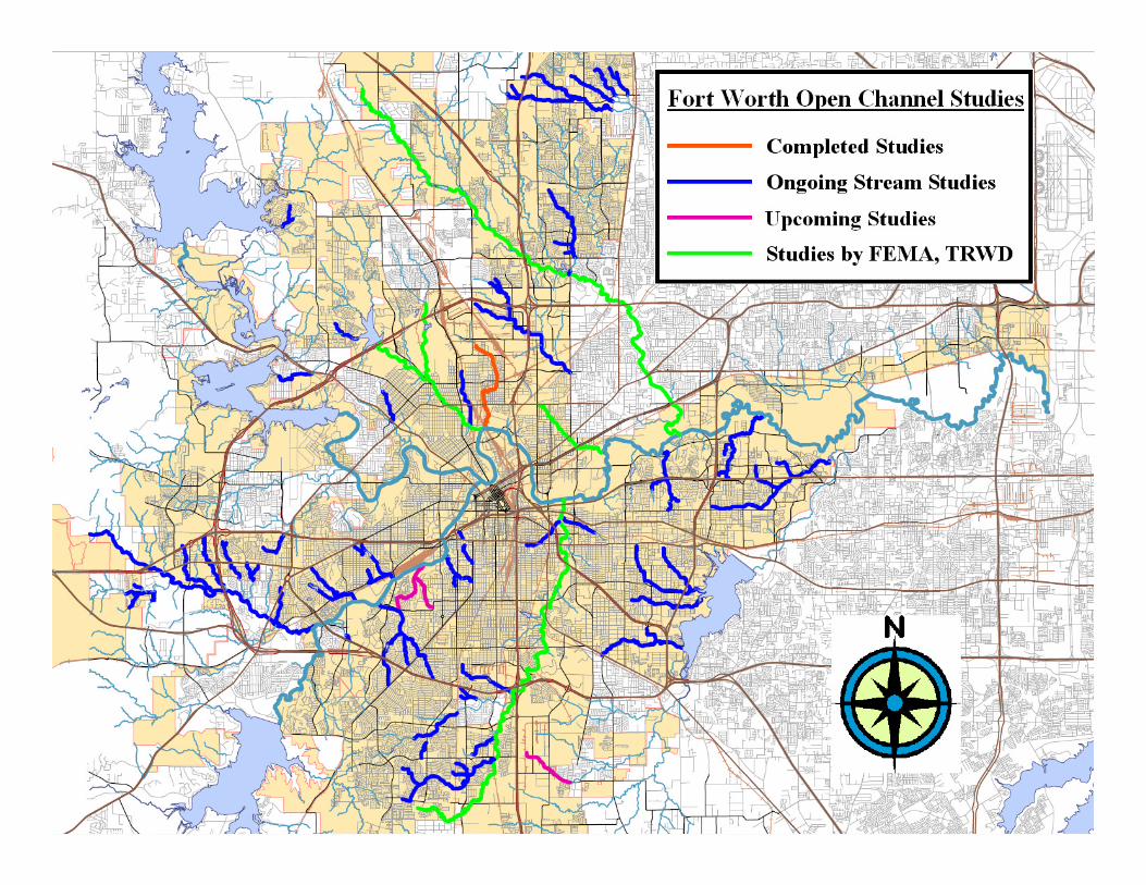
Fort Worth Stormwater Studies� Open Channel Studies
� 31 Under Contract
� 15 at 75% Review
� 5 at 90% Review5 at 90% Review
� 3 RAMPP, 2 TRWD
� Neighborhood Studies
� 9 in Progress
� Watershed Planning Studies
� 5 InfoWorks SD/2D Studies
Page 5
Open Channel Study Tasks
� Task 1: Project Management
� Task 2: Data Search, Collection, Field Investigation
� Task 3: Hydrologic Analysis
� Task 4: Hydraulic Analysis� Task 4: Hydraulic Analysis
� Task 5: Watershed Flood Hazard Assessment
� Task 6: Proposed Flood Mitigation Alternatives
� Task 7: Quality Assurance/Quality Control
� Task 8: Letter of Map Revision (LOMR)
Page 6
Task 2: Data Collection
� Data Search and Collection� Effective Models and Mapping
� Design Reports and Plans
� GIS and Terrain Information
� Historical Flood Complaints� Historical Flood Complaints
� Field Reconnaissance
� Channel/Structure Survey
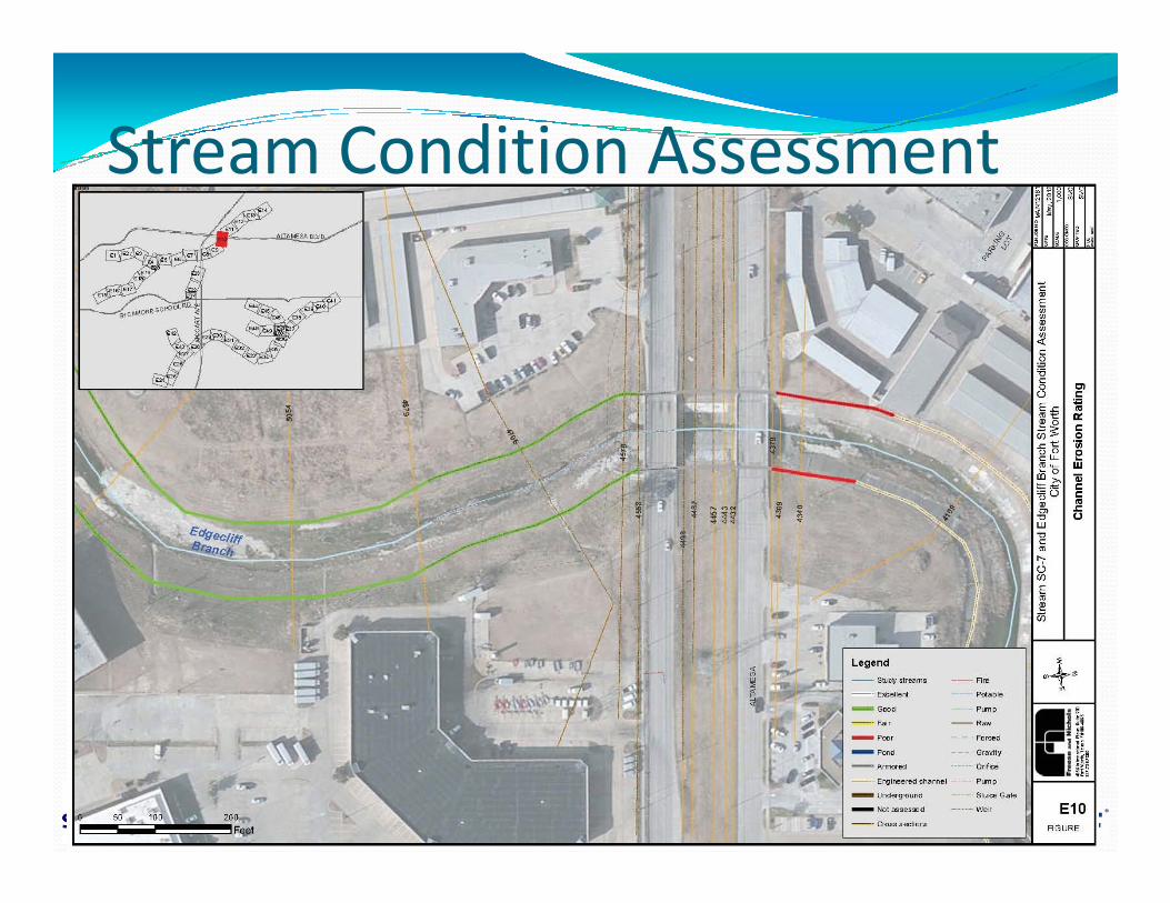
� Stream Condition Assessment� Evaluation of channel condition
� Erosion potential at structures
Page 7
Stream Condition Assessment
� Field Investigation
� Photograph and Document Conditions
� Assess Channel Condition
� Good, Fair, Poor� Good, Fair, Poor
� Areas of Imminent Failure
� Scour at Hydraulic Structures
� More Detailed Evaluation at City Request
Page 8
Drainage Complaints
� Gather records of drainage complaints in the watershed
� Comparison for Existing Results
� Minor Drainage Projects
Page 9
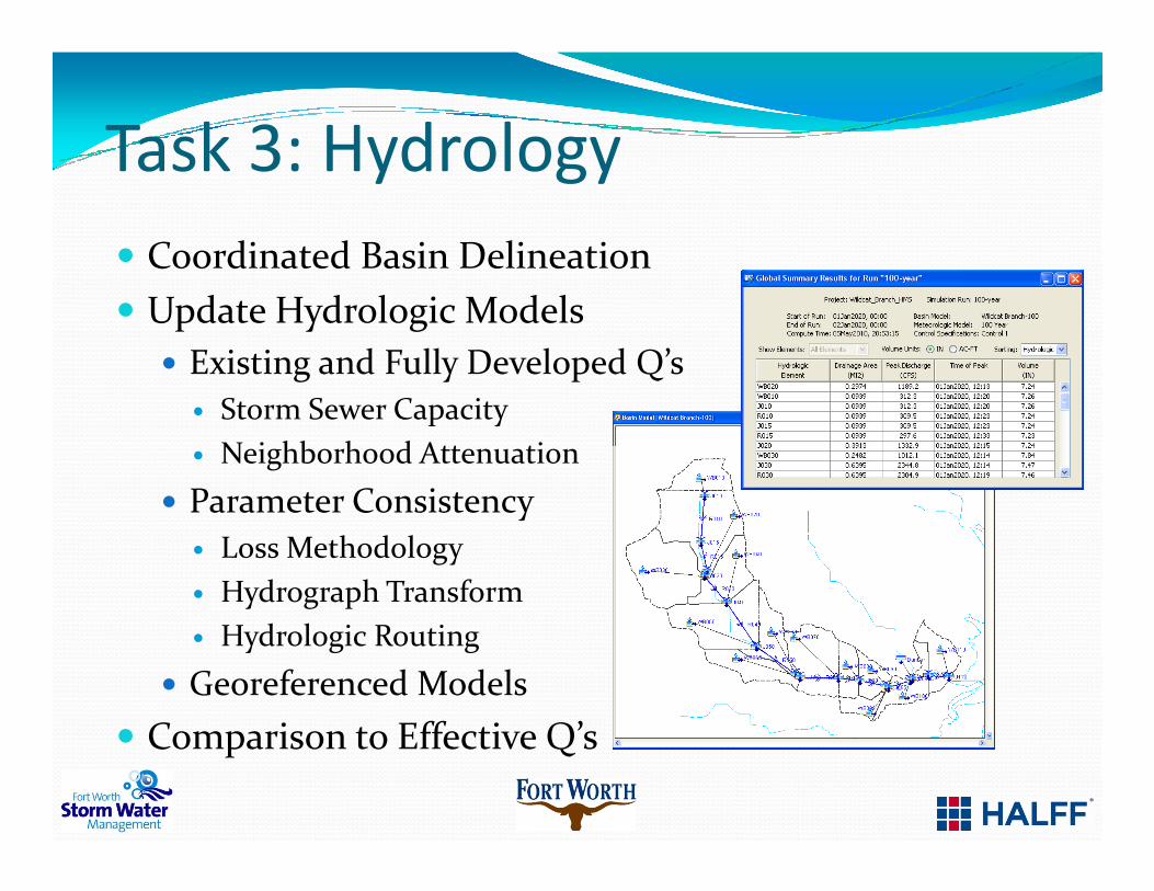
Task 3: Hydrology
� Coordinated Basin Delineation
� Update Hydrologic Models
� Existing and Fully Developed Q’s
� Storm Sewer Capacity
� Neighborhood Attenuation� Neighborhood Attenuation
� Parameter Consistency
� Loss Methodology
� Hydrograph Transform
� Hydrologic Routing
� Georeferenced Models
� Comparison to Effective Q’s
Page 10
Task 4: Hydraulics
� Update Hydraulic Models
� Cross Section Layouts
� Terrain and Survey Data
� Manning’s ‘n’ Guidelines
� Hydraulic Structures� Hydraulic Structures
� Encroachment Analysis
� Floodplain Mapping
� Existing Conditions
� Fully Developed
� Advanced Modeling
Page 11
Task 5: Hazard Assessment
� Inundation Frequencies at Crossings
� Areas of Regular Flooding
� At-Risk Structures
� High Velocities
Page 12
Task 6: Flood Mitigation
� Preliminary Alternative Identification
� Discussion with City & Consultant
� Identify External Factors and Stakeholders
� FW PACS, Gas Companies, TxDOT
� Select Alternatives for Development� Select Alternatives for Development
� H&H Modeling
� Gauge Effectiveness
� Identify Potential Impacts
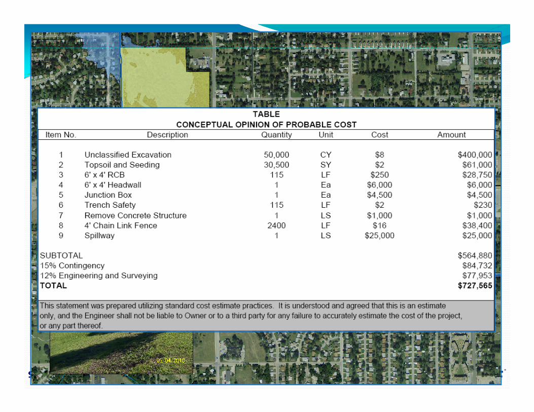
� Provide Conceptual Cost Estimate
� Benefit Cost Analysis
Page 13
Benefit Cost Analysis
� Survey FFE’s of Floodplain Structures
� Most Common Benefit/Cost Methods
� FEMA
� USACE
Factors Not Considered� Factors Not Considered
� Roadway Accessibility
� Intangibles (Vehicle Damage, Productivity Loss)
� Political Pressure
� Needs to be based on more than just Property Values
Page 14
Task 7: QA/QC
� Review of Models, Report Content, Formatting
� 75% Review – Completion of Tasks 1-5
� 90% Review – Completion of Task 6
� 100% Review – Completion of all tasks100% Review – Completion of all tasks
� Multiple Reviewers
� Halff Associates – Program Manager
� Fort Worth Stormwater Management
� Fort Worth Floodplain Administrator
Page 15
Task 8: Letter of Map Revision
� At Floodplain Administrators Discretion
� Existing Floodplain Limits
� Potential for Development
� Number of Structures Affected
No Effective Floodplain� No Effective Floodplain
Page 16
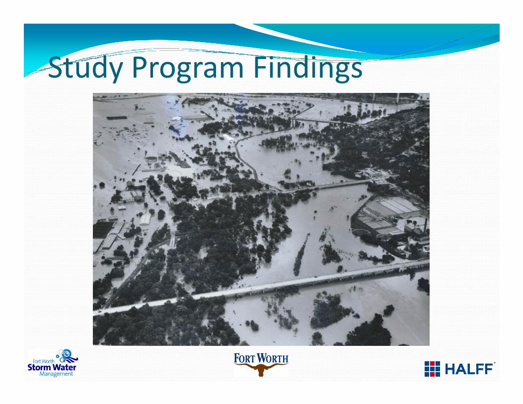
Study Program Findings
Page 17
Stream Condition Rating
Page 18
Drainage Area Comparison
Page 19
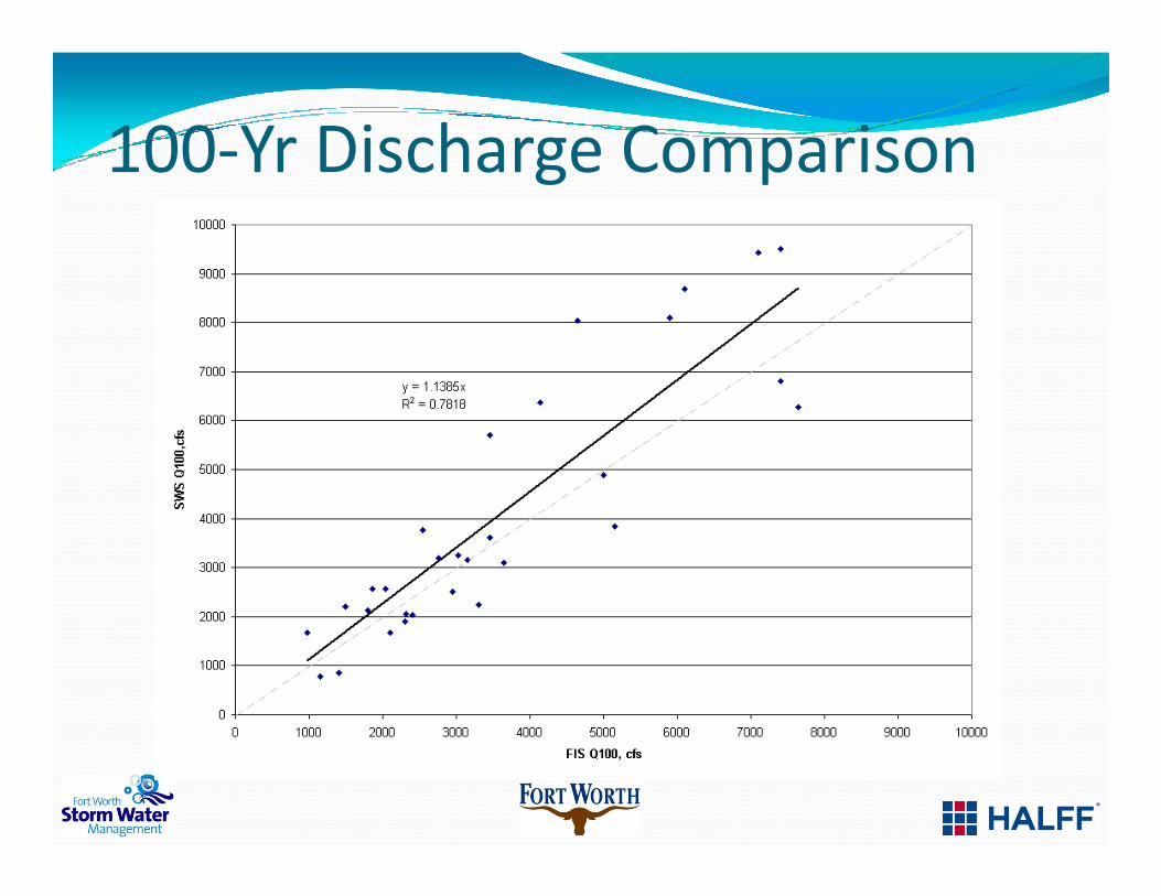
100-Yr Discharge Comparison
Page 20
Normalized Q100 Flows
Page 21
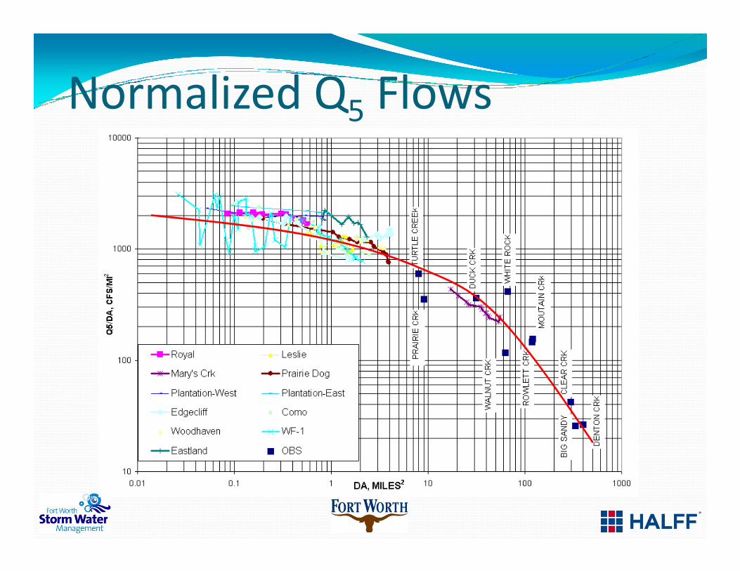
Normalized Q5 Flows
Page 23
Level of Service at Crossings
Page 24
SC-7/Edgecliff Floodplain - FIS
134 buildings
Page 25
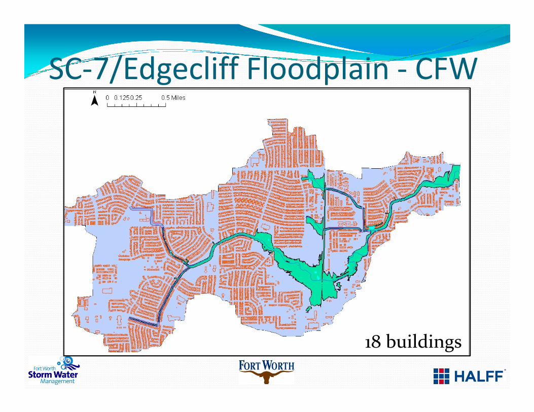
SC-7/Edgecliff Floodplain - CFW
18 buildings
Page 26
Cottonwood Floodplain - FIS
59 buildings
Page 27
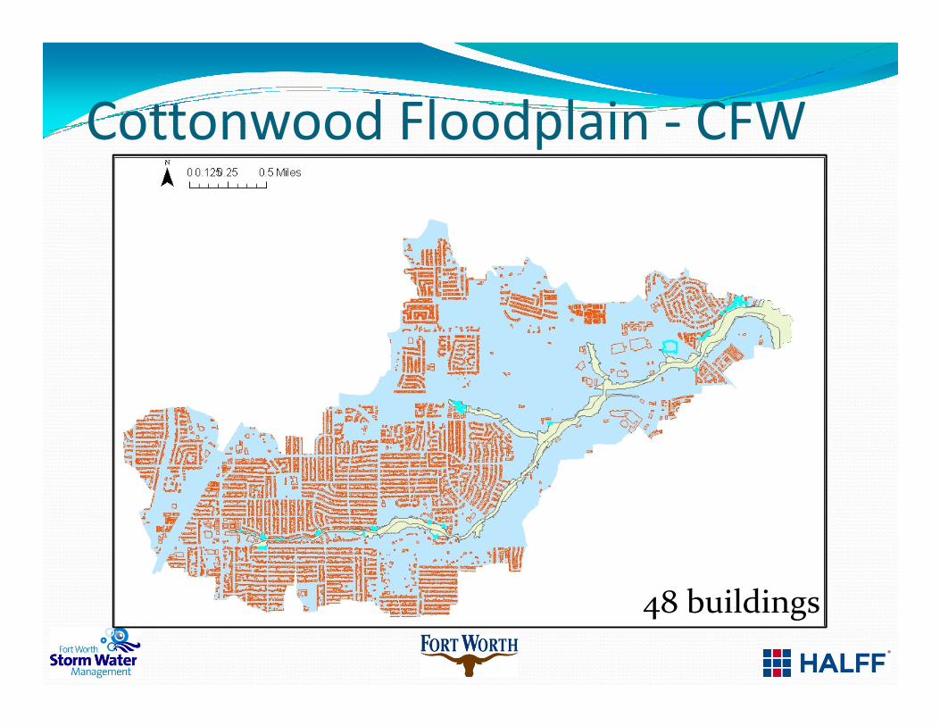
Cottonwood Floodplain - CFW
48 buildings
Page 28
Floodplain Area Comparison
Page 29
Flooded Structure Comparison
Page 30
Mitigation Alternatives
� BCA’s generally less than 1.0
� Mitigation Alternatives
� Detention Basins
� Upsize Road Crossings� Upsize Road Crossings
� Stream Widening or Lowering
� Home Buy-Outs
� Development of Feasibility Options Matrix
Page 31
Acknowledgements
� Floodplain Administration
� Clair Davis, P.E., CFM
� Amy Cannon, P.E, CFM
� Consultants
AECOMANA Consultants, LLCBaird, Hampton & BrownBrown & Gay EngineersCDM-SmithCP&YDunaway AssociatesFreese & Nichols, Inc.
Halff Associates, Inc.HDR Engineering, Inc.JacobsJames DeOtte EngineeringJerry Parche ConsultingKimley-Horn AssociatesLAN, Inc.MultaTech
SAIC, Inc.S&B InfrastructureTeague, Nall & PerkinsTranSystemsURS CorporationWade Trim