The aerial plans contained in this appendix (Appendix 1, AEE: Volume 2 of the CRL NoR suite of documents) are for information purposes only. They are provided to assist people reading the CRL NoR documentation to orientate and understand the location of the indicative rail tunnel alignments, station locations, and interchange, and the extent of the land requirement footprint for the CRL designation. Discrepancies between property boundaries and aerial information are common when these are overlaid. The Land Requirement Plans and the Schedule of Directly Affected Parties attached to each notice should be relied upon for determining what property is directly affected by the CRL designation. All land requirements are subject to final survey.
Transcript
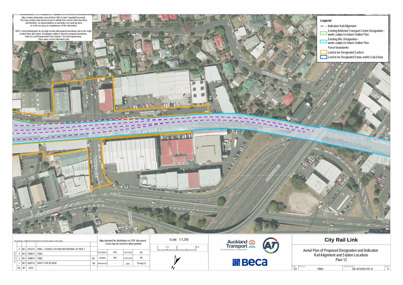
The aerial plans contained in this appendix (Appendix 1, AEE: Volume 2 of the CRL NoR suite of documents) are for information purposes only. They are provided to assist people reading the CRL NoR documentation to orientate and understand the location of the indicative rail tunnel alignments, station locations, and interchange, and the extent of the land requirement footprint for the CRL designation. Discrepancies between property boundaries and aerial information are common when these are overlaid. The Land Requirement Plans and the Schedule of Directly Affected Parties attached to each notice should be relied upon for determining what property is directly affected by the CRL designation. All land requirements are subject to final survey.
QUAY ST
GORE
ST
QUEEN ST
TYLER ST
COMM
ERCE
ST
GALWAY ST
WOLFE ST
CUSTOMS ST WEST
FORT LN
CUSTOMS ST EAST
FANSHAWE ST
ALBE
RT S
T
MILLS LN
LOWE
R AL
BERT
ST
FEDE
RAL S
T
IMPERIAL ACDEAC
DE A
RCAD
E 32
STURDEE ST
City Rail Link
A3STATUS: DRAWING NO: REV:
FINALSIZE:
This drawing is confidential and shall only be used for the purposes of this project.
No. BY DATE
REVIS
IONS DESIGNED
DRAWN
APPROVED
CHECKED
DATE
CHECKED
4
Aerial Plan of Proposed Designation and Indicative Rail Alignment and Station Locations
Plan 1GIS-4214293-103-1
±
1 HEC 20/07/12
HECHEC
-
OKOK
15-Aug-12
Map intended for distribution as PDF document. Scale may be incorrect when printed.
0 25 5012.5 m
DRAFT FOR REVIEW
LegendIndicative Rail AlignmentExisting Britomart Transport Centre Designation - works subject to future Outline PlanExisting NAL Designation -works subject to future Outline PlanParcel boundariesLand to be Designated SurfaceLand to be Designated Strata and/or Sub-Strata
Scale: 1:1,250
Map contains information sourced from LINZ (Crown Copyright Reserved).This map contains data derived in part or wholly from sources other than Beca
and therefore, no representations or warranties are made by Becaas to the accuracy or completeness of this information.
NOTE: Aerial photographs do not align exactly with property boundaries due to the angle at which they were taken. Designation outline is based on property boundaries.
Refer to Land Requirement Plans Volume 1 for land requirements. These plans are for information only.
OKOK
3 HEC 14/08/12 FINAL2 HEC 10/08/12 FINAL
4 HEC 14/12/12 FINAL - COUNCIL S92 AND WITHDRAWAL OF NOR 7
ALBERT ST
SWAN
SON
ST
WYND
HAM
ST
QUEEN ST
FEDERAL ST
VICTO
RIA
ST W
EST
WOLF
E ST
KING
STON
ST
MILL
S LN
DURH
AM ST
WES
T
DURHAM LN
FANSHAWE ST
EXCH
ANGE
LN
ST PATRICKS SQ
FEDERAL ST
City Rail Link
A3STATUS: DRAWING NO: REV:
FINALSIZE:
This drawing is confidential and shall only be used for the purposes of this project.
No. BY DATE
REVIS
IONS DESIGNED
DRAWN
APPROVED
CHECKED
DATE
CHECKED
4
Aerial Plan of Proposed Designation and Indicative Rail Alignment and Station Locations
Plan 2GIS-4214293-103-2
±1 HEC 20/07/12
HECHEC
-
OKOK
15-Aug-12
Map intended for distribution as PDF document. Scale may be incorrect when printed.
0 25 5012.5 m
DRAFT FOR REVIEW
LegendIndicative Rail AlignmentExisting Britomart Transport Centre Designation - works subject to future Outline PlanExisting NAL Designation -works subject to future Outline PlanParcel boundariesLand to be Designated SurfaceLand to be Designated Strata and/or Sub-Strata
Scale: 1:1,250
Map contains information sourced from LINZ (Crown Copyright Reserved).This map contains data derived in part or wholly from sources other than Beca
and therefore, no representations or warranties are made by Becaas to the accuracy or completeness of this information.
NOTE: Aerial photographs do not align exactly with property boundaries due to the angle at which they were taken. Designation outline is based on property boundaries.
Refer to Land Requirement Plans Volume 1 for land requirements. These plans are for information only.
OKOK
3 HEC 14/08/12 FINAL2 HEC 10/08/12 FINAL
4 HEC 14/12/12 FINAL - COUNCIL S92 AND WITHDRAWAL OF NOR 7
AOTEA STATION AREA
FEDERAL ST
ALBERT ST
ELLIOTT ST
VICTO
RIA
ST W
EST
WELL
ESLE
Y ST W
EST
MAYORAL DR
KING
STON
STDU
RHAM
ST W
EST
DURHAM LN
DARB
Y ST
MYERS ST
City Rail Link
A3STATUS: DRAWING NO: REV:
FINALSIZE:
This drawing is confidential and shall only be used for the purposes of this project.
No. BY DATE
REVIS
IONS DESIGNED
DRAWN
APPROVED
CHECKED
DATE
CHECKED
4
Aerial Plan of Proposed Designation and Indicative Rail Alignment and Station Locations
Plan 3GIS-4214293-103-3
±1 HEC 20/07/12
HECHEC
-
OKOK
15-Aug-12
Map intended for distribution as PDF document. Scale may be incorrect when printed.
0 25 5012.5 m
DRAFT FOR REVIEW
LegendIndicative Rail AlignmentExisting Britomart Transport Centre Designation - works subject to future Outline PlanExisting NAL Designation -works subject to future Outline PlanParcel boundariesLand to be Designated SurfaceLand to be Designated Strata and/or Sub-Strata
Scale: 1:1,250
Map contains information sourced from LINZ (Crown Copyright Reserved).This map contains data derived in part or wholly from sources other than Beca
and therefore, no representations or warranties are made by Becaas to the accuracy or completeness of this information.
NOTE: Aerial photographs do not align exactly with property boundaries due to the angle at which they were taken. Designation outline is based on property boundaries.
Refer to Land Requirement Plans Volume 1 for land requirements. These plans are for information only.
OKOK
3 HEC 14/08/12 FINAL2 HEC 10/08/12 FINAL
4 HEC 14/12/12 FINAL - COUNCIL S92 AND WITHDRAWAL OF NOR 7
HOBSON ST
VINCENT ST
MAYORAL DR
GREYS AVE
FEDERAL ST
COOK ST
MYERS S
T
City Rail Link
A3STATUS: DRAWING NO: REV:
FINALSIZE:
This drawing is confidential and shall only be used for the purposes of this project.
No. BY DATE
REVIS
IONS DESIGNED
DRAWN
APPROVED
CHECKED
DATE
CHECKED
4
Aerial Plan of Proposed Designation and Indicative Rail Alignment and Station Locations
Plan 4GIS-4214293-103-4
±1 HEC 20/07/12
HECHEC
-
OKOK
15-Aug-12
Map intended for distribution as PDF document. Scale may be incorrect when printed.
0 25 5012.5 m
DRAFT FOR REVIEW
LegendIndicative Rail AlignmentExisting Britomart Transport Centre Designation - works subject to future Outline PlanExisting NAL Designation -works subject to future Outline PlanParcel boundariesLand to be Designated SurfaceLand to be Designated Strata and/or Sub-Strata
Scale: 1:1,250
Map contains information sourced from LINZ (Crown Copyright Reserved).This map contains data derived in part or wholly from sources other than Beca
and therefore, no representations or warranties are made by Becaas to the accuracy or completeness of this information.
NOTE: Aerial photographs do not align exactly with property boundaries due to the angle at which they were taken. Designation outline is based on property boundaries.
Refer to Land Requirement Plans Volume 1 for land requirements. These plans are for information only.
OKOK
3 HEC 14/08/12 FINAL2 HEC 10/08/12 FINAL
4 HEC 14/12/12 FINAL - COUNCIL S92 AND WITHDRAWAL OF NOR 7
KARANGAHAPE STATION AREA
PITT ST
GREYS AVEVINCENT ST
KARA
NGAH
APE
RD
HOPETOUN ST BERE
SFOR
D SQ
POYNTON TCE
HOBSON ST
ST JAMES STUNIO
N ST
DAY ST
WARIMU PL
SAMOA HOUSE LN
City Rail Link
A3STATUS: DRAWING NO: REV:
FINALSIZE:
This drawing is confidential and shall only be used for the purposes of this project.
No. BY DATE
REVIS
IONS DESIGNED
DRAWN
APPROVED
CHECKED
DATE
CHECKED
4
Aerial Plan of Proposed Designation and Indicative Rail Alignment and Station Locations
Plan 5GIS-4214293-103-5
±1 HEC 20/07/12
HECHEC
-
OKOK
15-Aug-12
Map intended for distribution as PDF document. Scale may be incorrect when printed.
0 25 5012.5 m
DRAFT FOR REVIEW
LegendIndicative Rail AlignmentExisting Britomart Transport Centre Designation - works subject to future Outline PlanExisting NAL Designation -works subject to future Outline PlanParcel boundariesLand to be Designated SurfaceLand to be Designated Strata and/or Sub-Strata
Scale: 1:1,250
Map contains information sourced from LINZ (Crown Copyright Reserved).This map contains data derived in part or wholly from sources other than Beca
and therefore, no representations or warranties are made by Becaas to the accuracy or completeness of this information.
NOTE: Aerial photographs do not align exactly with property boundaries due to the angle at which they were taken. Designation outline is based on property boundaries.
Refer to Land Requirement Plans Volume 1 for land requirements. These plans are for information only.
OKOK
3 HEC 14/08/12 FINAL2 HEC 10/08/12 FINAL
4 HEC 14/12/12 FINAL - COUNCIL S92 AND WITHDRAWAL OF NOR 7
KARANGAHAPE STATION AREA
CENTRAL MOTORWAY JUNCTIONEAST ST
PITT ST
CANA
DA S
T
KARA
NGAH
APE R
D
MERCURY LN
CROS
S ST
IAN MCKINNON DR
POYNTON TCE
UPPER QUEEN ST
BERES
FORD SQ
SOUTH ST
DAY ST
GALATOS ST
SERVICE LN ALEX
EVAN
S ST
SAMOA HOUSE LN
City Rail Link
A3STATUS: DRAWING NO: REV:
FINALSIZE:
This drawing is confidential and shall only be used for the purposes of this project.
No. BY DATE
REVIS
IONS DESIGNED
DRAWN
APPROVED
CHECKED
DATE
CHECKED
4
Aerial Plan of Proposed Designation and Indicative Rail Alignment and Station Locations
Plan 6GIS-4214293-103-6
±1 HEC 20/07/12
HECHEC
-
OKOK
15-Aug-12
Map intended for distribution as PDF document. Scale may be incorrect when printed.
0 25 5012.5 m
DRAFT FOR REVIEW
LegendIndicative Rail AlignmentExisting Britomart Transport Centre Designation - works subject to future Outline PlanExisting NAL Designation -works subject to future Outline PlanParcel boundariesLand to be Designated SurfaceLand to be Designated Strata and/or Sub-Strata
Scale: 1:1,250
Map contains information sourced from LINZ (Crown Copyright Reserved).This map contains data derived in part or wholly from sources other than Beca
and therefore, no representations or warranties are made by Becaas to the accuracy or completeness of this information.
NOTE: Aerial photographs do not align exactly with property boundaries due to the angle at which they were taken. Designation outline is based on property boundaries.
Refer to Land Requirement Plans Volume 1 for land requirements. These plans are for information only.
OKOK
3 HEC 14/08/12 FINAL2 HEC 10/08/12 FINAL
4 HEC 14/12/12 FINAL - COUNCIL S92 AND WITHDRAWAL OF NOR 7
CENTRAL MOTORWAY JUNCTION
SYMONDS ST
UPPER QUEEN ST
ST BENEDICTS ST
NEWT
ON R
D
ALEX
EVAN
S ST
STABLE LN
WEST
ST
IAN MCKINNON DR
KARA
KA ST
DACR
E ST
AUCK
LAND
-HAM
ILTON
MWY
EXMOUTH ST
HOHI
PERE
ST
DUNDONALD ST
RAND
OLPH
ST
GLEN
SIDE C
RES
AUCK
LAND
-HAM
ILTON
MWY
City Rail Link
A3STATUS: DRAWING NO: REV:
FINALSIZE:
This drawing is confidential and shall only be used for the purposes of this project.
No. BY DATE
REVIS
IONS DESIGNED
DRAWN
APPROVED
CHECKED
DATE
CHECKED
4
Aerial Plan of Proposed Designation and Indicative Rail Alignment and Station Locations
Plan 7GIS-4214293-103-7
±1 HEC 20/07/12
HECHEC
-
OKOK
15-Aug-12
Map intended for distribution as PDF document. Scale may be incorrect when printed.
0 25 5012.5 m
DRAFT FOR REVIEW
LegendIndicative Rail AlignmentExisting Britomart Transport Centre Designation - works subject to future Outline PlanExisting NAL Designation -works subject to future Outline PlanParcel boundariesLand to be Designated SurfaceLand to be Designated Strata and/or Sub-Strata
Scale: 1:1,250
Map contains information sourced from LINZ (Crown Copyright Reserved).This map contains data derived in part or wholly from sources other than Beca
and therefore, no representations or warranties are made by Becaas to the accuracy or completeness of this information.
NOTE: Aerial photographs do not align exactly with property boundaries due to the angle at which they were taken. Designation outline is based on property boundaries.
Refer to Land Requirement Plans Volume 1 for land requirements. These plans are for information only.
OKOK
3 HEC 14/08/12 FINAL2 HEC 10/08/12 FINAL
4 HEC 14/12/12 FINAL - COUNCIL S92 AND WITHDRAWAL OF NOR 7
NEWTON STATION AREA
EXMOUTH ST
NIKAU ST
SYMONDS ST
NEW NORTH RD
FLOWER ST
NEWT
ON R
D
BASQ
UE R
D
DUNDONALD ST
MOUNT EDEN
RD
STABLE LN
KORARI ST
ST BENEDICTS ST
KHYB
ER PA
SS R
D
SHADDOCK ST
HOHI
PERE
ST
City Rail Link
A3STATUS: DRAWING NO: REV:
FINALSIZE:
This drawing is confidential and shall only be used for the purposes of this project.
No. BY DATE
REVIS
IONS DESIGNED
DRAWN
APPROVED
CHECKED
DATE
CHECKED
4
Aerial Plan of Proposed Designation and Indicative Rail Alignment and Station Locations
Plan 8GIS-4214293-103-8
±1 HEC 20/07/12
HECHEC
-
OKOK
15-Aug-12
Map intended for distribution as PDF document. Scale may be incorrect when printed.
0 25 5012.5 m
DRAFT FOR REVIEW
LegendIndicative Rail AlignmentExisting Britomart Transport Centre Designation - works subject to future Outline PlanExisting NAL Designation -works subject to future Outline PlanParcel boundariesLand to be Designated SurfaceLand to be Designated Strata and/or Sub-Strata
Scale: 1:1,250
Map contains information sourced from LINZ (Crown Copyright Reserved).This map contains data derived in part or wholly from sources other than Beca
and therefore, no representations or warranties are made by Becaas to the accuracy or completeness of this information.
NOTE: Aerial photographs do not align exactly with property boundaries due to the angle at which they were taken. Designation outline is based on property boundaries.
Refer to Land Requirement Plans Volume 1 for land requirements. These plans are for information only.
OKOK
3 HEC 14/08/12 FINAL2 HEC 10/08/12 FINAL
4 HEC 14/12/12 FINAL - COUNCIL S92 AND WITHDRAWAL OF NOR 7
NIKAU ST
RURU
ST
SHADDOCK STFL
OWER
ST
NEW NORTH RD
FENTON STKO
RARI
ST
AKIRAHO ST
NGAH
URA
ST
PORT
ERS A
VEBASQUE RD
NEW NORTH RD
City Rail Link
A3STATUS: DRAWING NO: REV:
FINALSIZE:
This drawing is confidential and shall only be used for the purposes of this project.
No. BY DATE
REVIS
IONS DESIGNED
DRAWN
APPROVED
CHECKED
DATE
CHECKED
4
Aerial Plan of Proposed Designation and Indicative Rail Alignment and Station Locations
Plan 9GIS-4214293-103-9
±
1 HEC 20/07/12
HECHEC
-
OKOK
15-Aug-12
Map intended for distribution as PDF document. Scale may be incorrect when printed.
0 25 5012.5 m
DRAFT FOR REVIEW
LegendIndicative Rail AlignmentExisting Britomart Transport Centre Designation - works subject to future Outline PlanExisting NAL Designation -works subject to future Outline PlanParcel boundariesLand to be Designated SurfaceLand to be Designated Strata and/or Sub-Strata
Scale: 1:1,250
Map contains information sourced from LINZ (Crown Copyright Reserved).This map contains data derived in part or wholly from sources other than Beca
and therefore, no representations or warranties are made by Becaas to the accuracy or completeness of this information.
NOTE: Aerial photographs do not align exactly with property boundaries due to the angle at which they were taken. Designation outline is based on property boundaries.
Refer to Land Requirement Plans Volume 1 for land requirements. These plans are for information only.
OKOK
3 HEC 14/08/12 FINAL2 HEC 10/08/12 FINAL
4 HEC 14/12/12 FINAL - COUNCIL S92 AND WITHDRAWAL OF NOR 7
BOSTON RDNIKAU ST
ENFIELD ST
MOUN
T EDE
N RDSHADDOCK ST
FLOWER ST
WATER ST
NORMANBY RD
NUGE
NT ST
BURL
EIGH
ST
LAUDER RD
KORARI ST
RURU ST
MARY
ST
City Rail Link
A3STATUS: DRAWING NO: REV:
FINALSIZE:
This drawing is confidential and shall only be used for the purposes of this project.
No. BY DATE
REVIS
IONS DESIGNED
DRAWN
APPROVED
CHECKED
DATE
CHECKED
4
Aerial Plan of Proposed Designation and Indicative Rail Alignment and Station Locations
Plan 10GIS-4214293-103-10±1 HEC 20/07/12
HECHEC
-
OKOK
15-Aug-12
Map intended for distribution as PDF document. Scale may be incorrect when printed.
0 25 5012.5 m
DRAFT FOR REVIEW
LegendIndicative Rail AlignmentExisting Britomart Transport Centre Designation - works subject to future Outline PlanExisting NAL Designation -works subject to future Outline PlanParcel boundariesLand to be Designated SurfaceLand to be Designated Strata and/or Sub-Strata
Scale: 1:1,250
Map contains information sourced from LINZ (Crown Copyright Reserved).This map contains data derived in part or wholly from sources other than Beca
and therefore, no representations or warranties are made by Becaas to the accuracy or completeness of this information.
NOTE: Aerial photographs do not align exactly with property boundaries due to the angle at which they were taken. Designation outline is based on property boundaries.
Refer to Land Requirement Plans Volume 1 for land requirements. These plans are for information only.
OKOK
3 HEC 14/08/12 FINAL2 HEC 10/08/12 FINAL
4 HEC 14/12/12 FINAL - COUNCIL S92 AND WITHDRAWAL OF NOR 7
BOSTON RD
AUBURN ST
NORMANBY RD
NUGENT ST
AUCK
LAND
-HAM
ILTON
MWY
SEVERN ST
REEVES RD
LAUDER RD
KHYBER PASS RD
City Rail Link
A3STATUS: DRAWING NO: REV:
FINALSIZE:
This drawing is confidential and shall only be used for the purposes of this project.
No. BY DATE
REVIS
IONS DESIGNED
DRAWN
APPROVED
CHECKED
DATE
CHECKED
4
Aerial Plan of Proposed Designation and Indicative Rail Alignment and Station Locations
Plan 11GIS-4214293-103-11±1 HEC 20/07/12
HECHEC
-
OKOK
15-Aug-12
Map intended for distribution as PDF document. Scale may be incorrect when printed.
0 25 5012.5 m
DRAFT FOR REVIEW
LegendIndicative Rail AlignmentExisting Britomart Transport Centre Designation - works subject to future Outline PlanExisting NAL Designation -works subject to future Outline PlanParcel boundariesLand to be Designated SurfaceLand to be Designated Strata and/or Sub-Strata
Scale: 1:1,250
Map contains information sourced from LINZ (Crown Copyright Reserved).This map contains data derived in part or wholly from sources other than Beca
and therefore, no representations or warranties are made by Becaas to the accuracy or completeness of this information.
NOTE: Aerial photographs do not align exactly with property boundaries due to the angle at which they were taken. Designation outline is based on property boundaries.
Refer to Land Requirement Plans Volume 1 for land requirements. These plans are for information only.
OKOK
3 HEC 14/08/12 FINAL2 HEC 10/08/12 FINAL
4 HEC 14/12/12 FINAL - COUNCIL S92 AND WITHDRAWAL OF NOR 7
NEW NORTH RD
DOMINION RD
BRENTWOOD AVE
ACE PL
HAULTAIN ST
PORTERS AVE
FENTON ST
WYNYARD RD
HOROPITO ST
MINNIE ST
AKEPIRO ST
City Rail Link
A3STATUS: DRAWING NO: REV:
FINALSIZE:
This drawing is confidential and shall only be used for the purposes of this project.
No. BY DATE
REVIS
IONS DESIGNED
DRAWN
APPROVED
CHECKED
DATE
CHECKED
4
Aerial Plan of Proposed Designation and Indicative Rail Alignment and Station Locations
Plan 12GIS-4214293-103-12
±
1 HEC 20/07/12
HECHEC
-
OKOK
15-Aug-12
Map intended for distribution as PDF document. Scale may be incorrect when printed.
0 25 5012.5 m
DRAFT FOR REVIEW
LegendIndicative Rail AlignmentExisting Britomart Transport Centre Designation - works subject to future Outline PlanExisting NAL Designation -works subject to future Outline PlanParcel boundariesLand to be Designated SurfaceLand to be Designated Strata and/or Sub-Strata
Scale: 1:1,250
Map contains information sourced from LINZ (Crown Copyright Reserved).This map contains data derived in part or wholly from sources other than Beca
and therefore, no representations or warranties are made by Becaas to the accuracy or completeness of this information.
NOTE: Aerial photographs do not align exactly with property boundaries due to the angle at which they were taken. Designation outline is based on property boundaries.
Refer to Land Requirement Plans Volume 1 for land requirements. These plans are for information only.
OKOK
3 HEC 14/08/12 FINAL2 HEC 10/08/12 FINAL
4 HEC 14/12/12 FINAL - COUNCIL S92 AND WITHDRAWAL OF NOR 7