Field Trip Guide Book - P18 Florence - Italy August 20-28, 2004 Post-Congress P18 32 nd INTERNATIONAL GEOLOGICAL CONGRESS THE APULIA CARBONATE PLATFORM-MARGIN AND SLOPE, LATE JURASSIC TO EOCENE OF THE MAIELLA MT. AND GARGANO PROMONTORY: PHYSICAL STRATIGRAPHY AND ARCHITECTURE Leaders: M. Morsilli, G. Rusciadelli, A. Bosellini Volume n° 4 - from P14 to P36
THE APULIA CARBONATE PLATFORM-MARGIN AND SLOPE, LATE JURASSIC TO EOCENE OF THE MAIELLA MT. AND GARGANO PROMONTORY: PHYSICAL STRATIGRAPHY AND ARCHITECTURE
Leaders: M. Morsilli, G. Rusciadelli, A. Bosellini
Volume n° 4 - from P14 to P36
P18 copertina_R_OK C 25-05-2004, 14:25:10
The scientific content of this guide is under the total responsibility of the Authors
Published by: APAT – Italian Agency for the Environmental Protection and Technical Services - Via Vitaliano Brancati, 48 - 00144 Roma - Italy
Series Editors:Luca Guerrieri, Irene Rischia and Leonello Serva (APAT, Roma)
Field Trip Committee: Leonello Serva (APAT, Roma), Alessandro Michetti (Università dell’Insubria, Como), Giulio Pavia (Università di Torino), Raffaele Pignone (Servizio Geologico Regione Emilia-Romagna, Bologna) and Riccardo Polino (CNR, Torino)
Acknowledgments:The 32nd IGC Organizing Committee is grateful to Roberto Pompili and Elisa Brustia (APAT, Roma) for their collaboration in editing.
Graphic project:Full snc - Firenze
Layout and press:Lito Terrazzi srl - Firenze
P18 copertina_R_OK D 25-05-2004, 14:23:29
Florence - ItalyAugust 20-28, 2004
P18
32nd INTERNATIONAL GEOLOGICAL CONGRESS
Volume n° 3 - from P14 to P36
THE APULIA CARBONATE PLATFORM-MARGIN AND
SLOPE, LATE JURASSIC TO EOCENE OF THE MAIELLA MT. AND GARGANO PROMONTORY:
PHYSICAL STRATIGRAPHY AND ARCHITECTURE
AUTHORS: M. Morsilli¹, G. Rusciadelli², A. Bosellini¹
¹ Dipartimento di Scienze della Terra, Università di Ferrara, Ferrara - Italy ² Dipartimento di Scienze della Terra, Università di Chieti, Chieti - Italy
Post-Congress
P18_R_OK A 25-05-2004, 14:39:12
Front Cover:Pelagic mitric limestones and slumps (background) of the Maiolica Fm (Baia delle Zagare, Gargano Promontory)
P18_R_OK B 25-05-2004, 14:39:14
THE APULIA CARBONATE PLATFORM-MARGIN AND SLOPE, LATE JURASSIC TO EOCENE OF THE MAIELLA MT. AND GARGANO PROMONTORY:
PHYSICAL STRATIGRAPHY AND ARCHITECTURE P1
8
3 - P18
Vo
lum
e n
° 3
- f
rom
P1
4 t
o P
36
Leaders: M. Morsilli, G. Rusciadelli, A. Bosellini
Introduction The main goals of this fi eld trip are the stratigraphic architecture of the eastern margin of the Apulia Carbonate Platform (ACP) and the associated slope and basin sediments, along the unique on-land outcrop areas of this vast carbonate platform (Maiella Mountain and Gargano Promontory). The ACP represents a case study of a margin with different evolutionary stages through time, from a progradational to aggradational and from erosional to by-pass. Spectacular geometries and different systems are visible, in some cases at the seismic scale, with various facies associations and physical stratigraphic relationships. Onlap, interfi ngering, erosional features at different scale, slumpings, breccia bodies, graded beds, pelagics, are the main geometric features and associated sedimentary products. Drowning unconformities, scalloped margins and coalescence of various platform systems also characterize the evolution of this carbonate platform through time.The fi rst day will be spent to travel from Florence to the Maiella Mountain, in the Abruzzo Region. During the second day, the fi eld trip will start on the Maiella and focus on its spectacular abrupt contact between the platform facies and slope-to-basin sediments. In the late afternoon we will travel to the town of Vieste, in the eastern corner of the Gargano Promontory (Apulia Region). The third day we will start with a panoramic view of the sea-cliff (Pizzomunno) of the old town of Vieste, where an erosional surface between the Upper Cretaceous pelagic sediments and Middle Eocene calciturbidites and breccia bodies is clearly visible. Then we will move along the eastern coast of the Gargano to observe spectacular slumpings and breccia bodies in the basinal Maiolica Fm (Lower Cretaceous), and will reach the Mattinata area where the Maiolica Fm unconformably onlaps the fl ank of the underlying drowned platform. At the end of the day we will visit the Saraceno Mountain where, in a hundred meters high sea-cliff, is clearly visible the transition between Middle Eocene clinostratifi ed strata and sub-horizontal basinal sediments. The forth day will be spent in the Belvedere di Ruggiano area to observe the abrupt contact between Berriasian platform facies and Upper Cretaceous base-of-slope deposits. Then we move to the Val Carbonara section, where the interfi ngering between Lower Cretaceous margin and slope deposits is well exposed. These are abruptly truncated by a huge mid-Cretaceous
megabreccia event. The last stop of this fi eld trip will be in the Borgo Celano quarry, where many dinosaurs footprints have been recently discovered in a peritidal succession. In the late afternoon we will start to return to Florence.Topographic mapsMaiella area: I.G.M.I. maps (Istituto Geografi co Militare Italiano), scale: 1:100.000, Foglio n° 147, Lanciano. Scale: 1:25.000, Tavoletta 147IIINE “Pennapiedimonte”. Gargano Area: I.G.M.I. maps, scale: 1:50.000, Foglio n° 385, Vieste, F. n° 398 Mattinata, F. n° 397 Manfredonia.Geological MapsMaiella area: Donzelli G. (1968) Carta geologica della Maiella, Dipartimento di Scienze della Terra, Università di Chieti eds. Carta Geologica d’Italia, scale 1:100.000 F. n° 147 Lanciano. Vezzani and Ghisetti (1997) Carta Geologica dell’Abruzzo, scale 1:100.000, SELCA eds.Gargano Area: Carta Geologica d’Italia, scale 1:100.000 F. n° 156 San Marco in Lamis; F. n° 157 M.S. Angelo.Guide BooksMaiella area: Guide Geologiche Regionali n° 10 Abruzzo, BEMA Eds., 2003; Gargano Area: Guide Geologiche Regionali n° 8 Puglia e Monte Vulture, BEMA Eds., 1999; Bosellini et al., 2000. The eastern margin of the Apulia carbonate Platform: the Gargano transect. IAS fi eld trip guide book. WG4 Meeting Vieste.
Regional geologic settingThe Maiella Mt. and the Gargano Promontory represent the northern and the eastern outcropping portions of the ACP. The Maiella Mt. is the outermost tectonic unit of the Central Apennine thrust and fold belt, whereas the Gargano Promontory is a portion of the stable and relatively undeformed Southern Apennine foreland (Figure1). Their present-day setting derives from a different geological evolution, occurred during the last few million years, started with the involvement of the Mesozoic Tethyan passive margin into the lithospheric fl exure, associated to the Neoalpine collisional phase. From Miocene to present, the ACP was progressively involved in the building of the Apenninic Chain. In the Central Apennines, its internal part corresponds to an imbricate system of folded and thrusted units,
P18_R_OK 3 25-05-2004, 14:41:45
Vo
lum
e n
° 3
- f
rom
P1
4 t
o P
36
P18 -
Leaders: M.Morsilli, G. Rusciadelli, A. Bosellini
P1
8
while in the Southern Apennines it plunges westward below the terrigenous sediments of the Pliocene to Quaternary foredeep. Eastward, the ACP represents the stable and relatively undeformed foreland of the Apennine thrust belt, and it is buried below Pliocene and Quaternary siliciclastic deposits to the north, or partially exposed in the Apulia Region to the south-east.The ACP was a major paleogeographic element of the southern margin of the Mesozoic Tethys Ocean. It is one of the so-called peri-Adriatic platforms, which are comparable to the Bahamas banks in their carbonate
facies, shape, size, and subsidence rates and also in the internal architecture (D’Argenio, 1971; Bernoulli, 1972; Eberli et al., 1993). It faces the Meso-Cenozoic Umbria-Marche Basin to the north and the Adriatic Basin (Ionian Basin, sensu Zappaterra, 1990) to the east. Different interpretations exist about the extent and termination of the ACP toward the south and its paleogeographic relation with the Lagonegro-Molise Basin and the internal Lazio-Abruzzo and Campano-Lucana carbonate platforms (Mostardini and Merlini, 1986; Patacca et al., 1991; Ciarapica and Passeri, 2002 and references therein). A major controversy
Figure 1 - Geological map of the Central and Southern Apennines compiled from many Authors.
Figure 3 - Line drawing of a seimic line located in the Adriatic offshore, where is recorded the platform to basin transition of the APC. The Liassic faulted platform (Calcare Massiccio Fm) sealed by Middle to Upper Jurassic slope deposits exported from the platform margin. Note the scalloped Cretaceous margin and the thick wedge at the base of the slope, quite similar to the Maiella setting.
P18_R_OK 4 25-05-2004, 14:44:43
THE APULIA CARBONATE PLATFORM-MARGIN AND SLOPE, LATE JURASSIC TO EOCENE OF THE MAIELLA MT. AND GARGANO PROMONTORY:
PHYSICAL STRATIGRAPHY AND ARCHITECTURE P1
8
5 - P18
Vo
lum
e n
° 3
- f
rom
P1
4 t
o P
36
exists as regard the possible connection of the ACP with the African continent (see Bosellini, 2002 for discussion and general bibliography).The initial separation between the ACP and adjacent basinal areas is another open question. This separation is well documented starting from the Liassic, even though the beginning of the extension and the continental crustal thinning, linked to the Tethyan rifting is probably more ancient. This interpretation is suggested by the Lower Triassic basinal sediments (M. Facito Fm) of the Lagonegro Basin and by the highly different sedimentation rates recorded in the adjacent depositional areas of the Dolomia Principale (45 m/Ma as average) and of the Anidriti di Burano or equivalents (200 m/Ma as average), which indicate subsidence rates compatible with rifting regimes (Finetti, in press; Finetti et al., in press).The margin of the ACP is mostly buried under Tertiary and Quaternary deposits, but it can be well drawn from subsurface and outcrops data. To the southeast, the ACP margin is still perfectly preserved and not affected by strong compressive tectonics. It lies 20-30 km east of the present Apulia coast line (De Dominicis and Mazzoldi, 1989; De Alteriis and Aiello, 1993) (Figure2). To the northwest, about 15 km from the present Abruzzo coastal line, the ACP margin turns of about 90° and strikes in a SW direction toward the folded and thrusted units of the Lazio-
Abruzzo area. The ACP margin is characterized by an overall aggrading or slightly prograding architecture, characterised by different geometric and depositional features along its extent. In some areas, a depositional margin characterizes the platform to basin transition, with a 20° to 30° dipping slope extending for about 4-6 km basinward, from the platform break; in this case, bio-intraclastic deposits and breccias are exported downslope and drape the Liassic normal faults (Figure3). In other areas, the platform margin is characterized by an abrupt escarpment, recording an evolution from erosive to depositional conditions during the Late Cretaceous and Tertiary. Here, typical geometric and depositional features are represented by faults, scallops, large-scale onlaps and huge amount of breccias and megabreccias. This second type of margin setting characterises discrete portions of the ACP from south to north, both in subsurface (offshore of Brindisi, Bari and Ortona) and in outcrops (Gargano and Maiella areas) (Figure2). This fi eld trip will deal with both types of margin.
The geological framework of the Maiella MountainThe Maiella Mt. represents the most spectacular outcropping folded and thrusted structure of the external Abruzzi Apennines, and derives from the deformation of the internal sectors of the ACP
Figure 2 - The eastern margin (Jurassic-Lower Cretaceous) of the Apulia Platform, with interpreted scalloped structures, compiled from outcrops and subsurface data (modifi ed after Bosellini et al., 2000).
P18_R_OK 5 25-05-2004, 14:42:15
Vo
lum
e n
° 3
- f
rom
P1
4 t
o P
36
P18 -
Leaders: M.Morsilli, G. Rusciadelli, A. Bosellini
P1
8
(Figure1). The Maiella is characterized by a N-S to NW-SE oriented anticline, with an axial culmination in the central sectors (Figure4). The main folding and thrusting of the Maiella occurred during the Middle to Upper Pliocene (Calamita et al., 1996 and references therein; Crescenti et al., in press). Northward and eastward, gently eastward tilted Upper Pliocene - Pleistocene deposits unconformably seal Meso-Cenozoic carbonates, Messinian evaporites and
Lower Pliocene siliciclastic folded successions. The western fl ank of the Maiella anticline is truncated by a W-dipping normal fault (the Caramanico fault), extending for a length of about 30 km in a N-S/ NW-SE direction, with a maximum downthrow of about 3 km (Donzelli, 1968). Its activity is considered Messinian to Pliocene (Scisciani et al., 2000) or Quaternary (Ghisetti and Vezzani, 2002). Southward, the Maiella anticline is confi ned by the Sangro-Volturno line,
Figure 4 - Geological scheme of the Maiella Mountain and surrounding areas, Central Italy (compiled from many Authors).
P18_R_OK 6 25-05-2004, 14:42:19
THE APULIA CARBONATE PLATFORM-MARGIN AND SLOPE, LATE JURASSIC TO EOCENE OF THE MAIELLA MT. AND GARGANO PROMONTORY:
PHYSICAL STRATIGRAPHY AND ARCHITECTURE P1
8
7 - P18
Vo
lum
e n
° 3
- f
rom
P1
4 t
o P
36
separating a structural depression, where the Molise Allocthonous Units crop-out (Figs.1 and 4). The sedimentary succession of the Maiella records the complete geodynamic evolution from the late stages of the Tethyan post-rift (Early Cretaceous) to the stress inversion that precedes the closure of the western Alpine Tethys (Late Cretaceous-Early Tertiary), up to the fi nal stages of the building process of the Central Apenninic chain (Pliocene-Pleistocene). The Cretaceous stratigraphic units represent different depositional environments: the inner platform, in the southern and central areas, the slope and basin in the northern sectors. The Cretaceous sedimentary evolution of the Maiella is characterized by the transition between an escarpment-bounded platform to a carbonate ramp. During the Tertiary, depositional conditions were more homogeneous and dominated by carbonate ramps until the early Messinian. Starting from the late Messinian, concomitantly with the evaporitic event, the Maiella and the surrounding areas are progressively involved in the deformation associated to the migration of the chain-foredeep-foreland system; the carbonate deposition stops and it is defi nitively replaced by siliciclastic deposits, wich records the complete evolution from foredeep to shoreface depositional systems.
Stratigraphic framework of the Maiella MountainThe Cretaceous lithostratigraphic framework of the Maiella here presented mainly derives from studies by Crescenti et al. (1969), Catenacci (1974), and successively implemented by Accordi et al. (1987), Accarie (1988), Vecsei, (1991), Eberli et al. (1993), Mutti et al. (1996), Sanders (1996), Rusciadelli and Vichi (1998), Stössel (1999), Morsilli et al. (2000, 2002, in press), Rusciadelli et al. (2003), Rusciadelli (in press) (Figure5). 1) Morrone di Pacentro Formation (Early Cretaceous) (Crescenti et al., 1969). This formation is made up of 10 cm to few meters thick, grey to beige limestones. Textures are mudstones to bioclastic and/or oolithic grainstones, with frequent gastropods (nerineids) and lamellibranches. These lithofacies allow to refer this formation to an internal platform with transition to a sandy open margin 2) Cima delle Murelle Formation (Late Cenomanian p.p.- Campanian p.p.) (Vecsei, 1991). It lies on the fi rst bauxitic level and it is composed by the whole range of textures, from mudstones to oolithic and bioclastic grainstones, centimetre to metre thick. Rudist biostromes (Radiolitids and Hippuritids) frequently occur at different stratigraphic intervals. These lithofacies are organized into few meters thick cycles, frequently characterised by surfaces of
subaerial exposure at the top. This facies association has been referred to a platform margin periodically infl uenced by high energy conditions.3) Bocca di Valle Formation (Albian p.p. Early Cenomanian). It is made up of thin micritic pelagic limestones alternating with medium to thick bioclastic packstones and grainstones and thick bodies of breccias with p l a t f o r m - d e r i v e d clasts. Black shales levels intercalate in
Figure 5 - Chronostratigraphy and lithostratigraphic nomenclature of Cretaceous successions of the Maiella Mountain defi ned by Crescenti et al. (1969), Catenacci (1974), Accarie et al. (1986), Accarie (1988), Accordi et al. (1987), Vecsei (1991), Eberli et al. (1993), Mutti et al. (1996), Sanders (1996) and Rusciadelli (unpublished data).
P18_R_OK 7 25-05-2004, 14:42:26
Vo
lum
e n
° 3
- f
rom
P1
4 t
o P
36
P18 -
Leaders: M.Morsilli, G. Rusciadelli, A. Bosellini
P1
8
the lower part of the unit. This unit corresponds to the Marne a Fucoidi of the basinal areas. Lithofacies indicate a base-of-slope depositional setting.4) Valle dell’Inferno Formation (Cenomanian p.p). (Accarie, 1988; Vecsei, 1991). It is mainly composed by metre scale beds, often amalgamated, made of bioclastic packstones and grainstones. Breccias and megabreccias bodies, with platform-derived clasts, characterise the lower part of this unit. The depositional environment is referable to a slope to base-of-slope transition.
5) Tre Grotte Formation (Turonian-Campanian p.p.) (Vecsei, 1991). It is represented by different lithofacies, such as thin to medium mudstones-wackestones with planktonic foraminifera, medium to thick bioclastic frequently graded packstones-grainstones, and lenticular, metre to ten metres thick breccias and megabreccias. This unit onlaps the Lower and Upper Cretaceous platform and margin successions of the Morrone di Pacentro and Cima delle Murelle. This unit has been referred to a slope to base-of-slope transition.6) Orfento Formation (Campanian p.p.-Maastrichtian). (Crescenti et al., 1969). It is essentially composed by lenticular bodies and cross bedded bioclastic grainstones and rudstones. The bioclastic fraction is represented by rudist fragments. Sedimentological features allow to refer this unit to a high energy carbonate ramp with bioclastic shoals migrating toward a shallow basin (Eberli et al., 1993; Mutti et al., 1996).
The Maiella paleoescarpment The paleoescarpment is one of the most intriguing features of the Maiella geology. It corresponds to a rather irregular surface, more or less E-W oriented and dipping northward with angles ranging between 20° and 40° (Crescenti et al., 1969; Accarie et al., 1989; Vecsei, 1991; Eberli et al., 1993; Morsilli et al., 2002). It truncates Lower and Upper Cretaceous platform facies (Morrone di Pacentro and Cima delle Murelle) along a 1000 m high surface on which Upper Cretaceous slope deposits onlap.From the fi rst recognition of the paleoescarpment (Crescenti et al., 1969), the interpretation of this paleogeographic element has been referred both to sedimentary and structural models (Figure6). Structural models (Accarie, 1988; Accordi et al., 1987) apply the ’60 classical model of faulted platform to basin transition, with the paleoescarpment represented by a series of tilted blocks displaced by a fault system. A sedimentary model, based on the confi gurations of modern platform to basin transitions (Bahamas model), is envisaged by the ETH group of Bernoulli (Vecsei, 1991; Stössel, 1999). This model consider the paleoescarpment as the product of a long-lived evolution, started during the Tethyan rifting phase, with the dissection of the Liassic platform and the initial separation between platform and basin sectors. According to this model, the paleoescarpment represents a by-pass and erosive surface, separating basinal areas from an aggrading platform that kept
Figure 6 - Various models proposed for the contact between platform and slope-to-basin deposits in the Maiella Mt.
P18_R_OK 8 25-05-2004, 14:42:29
THE APULIA CARBONATE PLATFORM-MARGIN AND SLOPE, LATE JURASSIC TO EOCENE OF THE MAIELLA MT. AND GARGANO PROMONTORY:
PHYSICAL STRATIGRAPHY AND ARCHITECTURE P1
8
9 - P18
Vo
lum
e n
° 3
- f
rom
P1
4 t
o P
36
up during time. Only during the Late Cretaceous, the paleoescarpment was sealed and the platform architecture changed from aggrading to prograding (Crescenti et al., 1969; Eberli et al., 1993). A more recent sedimentary model is proposed by Morsilli et al. (2002). They consider the paleoescarpment as the remnant surface of a series of submarine landslides, formed during an imposing phase of platform margin collapses. Successively, through a mechanical quantitative modelling, Rusciadelli et al. (2003) highlighted the fundamental role of earthquake swarms in the formation of the large-scale margin collapses.
The geological framework of the Gargano PromontoryThe Gargano Promontory is a gentle NW-SE trending regional anticline where the oldest units of Late Jurassic age reach an elevation of 1000 m. The structure is complicated by several E-W, NE-SW and NW-SE trending steep to subvertical normal and strike-slip faults (Figure7). One of the most impressive structural features of the Gargano is a major E-W horizontal shear zone (Val Carbonara Fault, Mattinata Fault or Mattinata-Gondola Fault Zone). As shown by seismic profi les, the Mattinata Fault continues offshore for tens of kilometres
(Gondola Line of De Dominicis and Mazzoldi, 1989). Quite controversial is the kinematics of this structure. It has been interpreted as right-lateral (Guerricchio, 1986, 1996; Finetti and Del Ben, 1986; De Dominicis and Mazzoldi, 1989; Bosellini et al., 1993; Doglioni et al., 1994), left-lateral (Funiciello et al., 1992; Favali et al., 1992; Salvini et al., 1999; Billi, 2003), right- to left-lateral inverted (de Alteriis, 1995; Gambini and Tozzi, 1996) or as a reverse fault (Ortolani and Pagliuca, 1989). The Mattinata fault is a complex structure that records different kinematics related to changes in the stress regime through time (Morsilli, 1998). Chilovi et al. (2000) indicate a complex history of this structure: Mesozoic extensional regime, followed by a Late Miocene to Early Pliocene left-lateral displacement and Late Pliocene to Quaternary right-lateral activity. Recently, the Gargano has been interpreted as a Neogene contractional belt (Bertotti et al., 1999) with many thrust structures previously interpreted as normal faults (Figure8). Until the early Miocene, the Gargano was poorly deformed, but during Langhian to Tortonian times a tectonic phase starts to deform the previous and sindepositional units with gentle folds and thrusts. Between the Late Miocene and the early (?) Pliocene, NE-SW trending normal faults developed in the Gargano area, leading fi nally the
Figure 7 - Satellite image (Landsat TM) of the Gargano Promontory. The Mattinata Fault is the main E-W striking alignement visible in the southern part of the image
P18_R_OK 9 25-05-2004, 14:42:33
Vo
lum
e n
° 3
- f
rom
P1
4 t
o P
36
P18 -
Leaders: M.Morsilli, G. Rusciadelli, A. Bosellini
P1
8
uplift of the Promontory. Post-Pliocene deformation consists of gentle NW-SE trending folds and strike-slip faults (Bertotti et al., 1999).
Stratigraphic framework of the Gargano PromontoryThe backbone of the Gargano Promontory consists of a thick pile of Jurassic and Cretaceous shallow-water carbonates. The structurally elevated position of the Gargano and the consequent erosion of the younger sediments prevent us from knowing the exact thickness of the Jurassic-Cretaceous succession. The entire thickness of the ACP has been estimated of about 6000 m by Mostardini and Merlini (1986), but,
according to the wells Gargano-1 and Foresta Umbra-1, the total thickness of the Jurassic-Cretaceous succession of the Gargano Promontory can be conservatively estimated to be around 3000-3500 m (Bosellini et al., 1993). This huge Jurassic-Cretaceous platform, which passes eastward into slope and basinal deposits, overlies a thick dolomite-evaporite succession, the so called Burano Anhydrite (Anidriti di Burano) (Martinis and Pieri, 1964) of Late Triassic age, visible in a quite small outcrop near the Lake of Lesina (Punta delle Pietre Nere) (Posenato et al., 1994).On the basis of many regional or local events, that have formed major unconformities, the Gargano
Figure 9 - Chronostratigraphic chart showing formations, second-order sequences and “systems tracts” of the Gargano Promontory (modifi ed after Bosellini et al., 1999). 1) Inner platform facies; 2) margin facies; 3) slope and base-of-slope facies; 4) basin facies; 5) megabreccias; 6) hiatuses; 7) bauxites. Time scale after Gradstein et al. (1995).
Figure 8 - Geological section of the Gargano Promontory with the interpreted deep thrust (after Bertotti et al., 1999).
P18_R_OK 10 25-05-2004, 14:42:36
THE APULIA CARBONATE PLATFORM-MARGIN AND SLOPE, LATE JURASSIC TO EOCENE OF THE MAIELLA MT. AND GARGANO PROMONTORY:
PHYSICAL STRATIGRAPHY AND ARCHITECTURE P1
8
11 - P18
Vo
lum
e n
° 3
- f
rom
P1
4 t
o P
36
stratigraphy has been subdivided into many second order depositional sequences (Figure9) (Bosellini et al., 1993, 1999). They corresponds to the supersequences or megasequences of Hubbard, (1988), Vail et al., (1991), among others.Monte Sacro Sequence (Callovian p.p.-Valanginian p.p.) - This sequence (the lower boundary is not exposed) is composed of fi ve lithostratigraphic units that represents a broad spectrum of depositional environments from the inner platform to the basin, they include the following.(1) Sannicandro Formation. This unit crops out only in the western and central sector of the Gargano and consists of a thick succession of meter-scale (1-5 m) peritidal parasequences representing lagoon to supratidal environments. Common lithofacies include mudstone-wackestone rich in dasycladacean algae, ostracods, gastropods (Nerinea sp.), and peloidal to oolitic packstone-grainstone. Birdseye structures, fenestral fabric, and stromatolite layers, associated with fl at-pebble breccias, are common at the cycle tops.(2) Monte Spigno Formation. This unit crops out
in the central area of the Gargano promontory and consists mainly of oolitic and oncolitic grainstones. Sedimentary structures include current and wave ripples and low-angle planar laminations (dune scale). Meniscus cements and keystone vugs are common features in thin section. This facies suggests a shallow-water high-energy setting, such as oolitic shoals with local zones of emersion.(3) Monte Sacro Limestone. This formation occurs in a narrow and arched belt from Monte d’Elio to Mattinata and consists of massive wackestone rich in Ellipsactinia, Sphaeractinia, and stromatoporoids (Figure10). This facies association is interpreted to represent a spectrum of environments from reef front to external margin (Morsilli and Bosellini, 1997). The landward boundary with the Monte Spigno Fm is gradual with a zone of skeletal sands and scattered branching coral colonies in life position (patch-reefs). (4) Ripe Rosse Formation. It corresponds to the Casa Varfone formation of Bosellini and Morsilli (1994) and consists of thick-bedded skeletal rudstone, stromatoporoid breccias, and graded grainstones interfi ngering with cherty lime mudstones. Clasts are mainly fragments of Ellipsactinia, Sphaeractinia, stromatoporoids, and corals. The geometric relationships observable in the fi eld support the interpretation that this facies association is a proximal to distal, clinostratifi ed slope succession (Figure11). Upslope it passes into the Monte Sacro Limestone.(5) Maiolica 1. It is the well known formation of the Mediterranean basinal sediments of Late Jurassic-Early Cretaceous age. It consists of white, thin bedded, micritic limestone with cherts, rich in calpionellids and Nannoconus. Slump features (intraformational folds, truncation surfaces) are quite
Figure 10 - Ellipsactinia sp. in the Monte Sacro Limestone (Monte di Mezzo – Carpino).
Figure 11 - The Upper Jurassic-Lower Cretaceous depositional fl ank of the Apulia Platform (Ripe Rosse - Lame di Milo, north of Mattinata).
P18_R_OK 11 25-05-2004, 14:42:42
Vo
lum
e n
° 3
- f
rom
P1
4 t
o P
36
P18 -
Leaders: M.Morsilli, G. Rusciadelli, A. Bosellini
P1
8
common (Figure12).Upper Sequence Boundary --- Near the town of Mattinata, the inclined surface of the platform slope of Berriasian-earliest Valanginian age is onlapped by a thick succession of white, thin-bedded micritic limestones of the Maiolica 2 Fm. The physical stratigraphic relationships (Figure13) are clearly unconformable and suggest the existence of a drowning unconformity (sensu Schlager, 1989) (Bosellini and Morsilli, 1997).
Mattinata 1 Sequence (Valanginian p.p.- Early Aptian) - This sequence is mainly represented by inner-platform and slope-to-basin facies. (1) San Giovanni Rotondo 1 Limestone. This unit is a thick succession (500-600 m) of shallow-water limestone that can be subdivided into three members (Claps et al., 1996). Member 1 consists of a
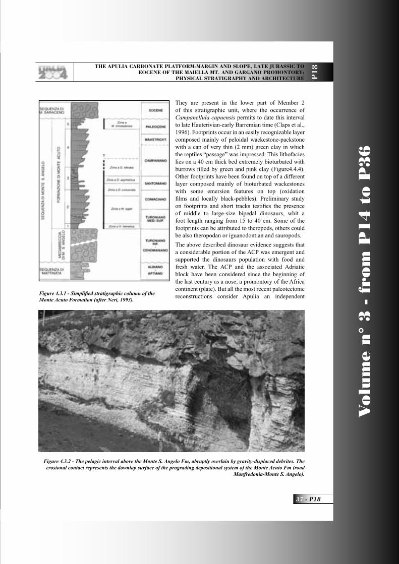
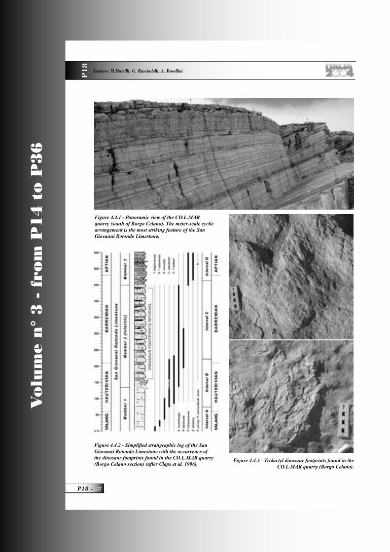
monotonous and acyclic subtidal succession. Member 2 is represented by a thick cyclic unit characterized by quasi-periodic alternation of “loferitic” beds and centimetre-thick layers of green shales, deposited in a tidal-fl at setting. Many dinosaur footprints have been recently discovered in a quarry near Borgo Celano (Gianolla et al., 2000). Member 3 displays a variety of facies including subtidal high-energy thin-bedded calcarenites at the base of parasequences and domal stromatolites in the upper part (Figure14).(2) Monte degli Angeli 1 Limestone. It represents the bioconstructed margin of the platform and consists of skeletal sand and stromatoporoid boundstone and rudstone with scattered coral fragments. It crops out only at the Monte degli Angeli (lower part), to the
west of Monte S. Angelo. (3) Mattinata 1 Formation. This unit is a slope and base-of-slope carbonate succession, rich in gravity-displaced deposits (calciturbidites, breccias), interbedded with cherty micritic limestone, commonly slumped (Luciani and Cobianchi 1994; Cobianchi et
Figure 13 - The massive slope (right) of the Apulia Platform (Late Jurassic-Berriasian) and the adjacent onlapping basinal succession (left) of Valanginian p.p.-Hauterivian age. Locality Coppa di Montelci,north of Mattinata.
Figure 14 - Domal stromatolite, member 2 of the S. Giovanni Rotondo Limestone (Borgo Celano).
Figure 12 - Slump structures in the Maiolica Fm (Gattarella cove).
P18_R_OK 12 25-05-2004, 14:42:45
THE APULIA CARBONATE PLATFORM-MARGIN AND SLOPE, LATE JURASSIC TO EOCENE OF THE MAIELLA MT. AND GARGANO PROMONTORY:
PHYSICAL STRATIGRAPHY AND ARCHITECTURE P1
8
13 - P18
Vo
lum
e n
° 3
- f
rom
P1
4 t
o P
36
al., 1997). The type section is exposed near the town of Monte S. Angelo, along the road to Val Carbonara and S. Giovanni Rotondo.(4) Maiolica 2. Same facies of the Maiolica 1 described above.Upper Sequence Boundary --- There is a rather abrupt change in lithology in slope and basinal settings: both the Maiolica 2 and Mattinata 1 Fm are overlain by a marly and shaly succession, the so-called Scisti a Fucoidi Formation (Cobianchi et al., 1997), early Aptian-late Albian in age. From a physical stratigraphic point of view, the sequence boundary is clearly a drowning event: the platform and its bioclastic apron (Mattinata Fm) is abruptly backstepped for some 5-10 km, suggesting that shallow deposition was terminated in a short time.
Mattinata 2 Sequence (Early Aptian - Late Albian) - This sequence is largely represented by slope and basin deposits. Equivalent shallow-water deposits are present only at Monte degli Angeli and Coppa di Pila and in the area between Rignano and Manfredonia. The sequence, characterized in the upper part by a strong progradational trend, is represented by the following formations.(1) San Giovanni Rotondo 2 Limestone. This unit, which corresponds to Masseria Quadrone Limestone of Merla et al. (1969), is an inner-platform succession of Albian-Cenomanian? age. It consists of thick beds of mudstone-wackestone with peloidal packstone-grainstone intercalations. Recently, Luperto Sinni (1996) described a thin succession (about 30 m) of mudstone-packstone with late Albian orbitolinids in the same area; the top consists of a Sellialveolina vialli-bearing limestone, early Cenomanian in age. (2) Monte degli Angeli 2 Limestone. It is the Late Aptian to Middle-Late Albian tract of the Lower Cretaceous margin of the ACP. It is grafted onto the underlying Hauterivian-early Aptian platform margin, but, in places, there may be 1-2 m of pelagic limestone. The Monte degli Angeli Limestone is rich in sponges, chaetetids, corals, and rudists and represents the bioconstructed margin of this sequence. The age of the outcropping part of this formation is limited to the late Aptian, whereas the Albian part is documented only in platform-derived breccia occurring in the Mattinata 2 Fm.(3) Marne a Fucoidi Formation. This lithological unit, rich in marls and black shales, deposited during episodic anoxic events (Cobianchi et al., 1997; 1999), has a maximum thickness of 120 m in the northern
Gargano (Figure15), and overlies both the Maiolica 2 and Mattinata 1 formations. It clearly represents a rather abrupt change in the basinal sedimentation and is associated with a standstill in the platform evolution. In the Monte S. Angelo area, the Marne a Fucoidi wedges out against the platform slope and is absent on the platform top, where a few meters of pelagic limestone or an unconformity surface are present.(4) Mattinata 2 Formation. It is the same slope and base-of-slope succession as the previously described Mattinata 1 Fm, from which it is separated by a wedge of pelagic limestone with thin beds of black shale (Marne a Fucoidi Fm). The Aptian-Albian tract
Figure 15 - Stratigraphic section of the Marne a Fucoidi Fm in the northern Gargano (Fontanelle section
– Ischitella) (after Cobianchi et al. 1997)
P18_R_OK 13 25-05-2004, 14:42:48
Vo
lum
e n
° 3
- f
rom
P1
4 t
o P
36
P18 -
Leaders: M.Morsilli, G. Rusciadelli, A. Bosellini
P1
8
of Mattinata Fm is more rich in graded breccias and calciturbidites. Upper Sequence Boundary --- It is a major erosional unconformity of regional extent. On the platform, it corresponds to well known karst and bauxite horizons developed over the entire peri-Adriatic region (Crescenti and Vighi, 1964; Accarie et al., 1989; D’Argenio and Mindszenty, 1991; Carannante et al., 1992; Mindszenty et al., 1995). In the slope and base-of-slope settings, the Mattinata and Marne a Fucoidi formations are unconformably overlain by a huge megabreccia; the boundary is clearly erosional.
Monte S. Angelo 1 Sequence (Late Albian-Santonian) - This sequence consists mainly of slope and basinal, fully pelagic sediments. The shallow-water tract of the sequence is represented by a small outcrop in the western and southern part of the promontory. (1) Altamura Limestone. This formation, previously known as Casa Lauriola Limestone (Merla et al., 1969), consists of shallow-water, subtidal to peritidal carbonates, and crops out in two zones, near S. Giovanni Rotondo and near Apricena. It unconformably overlies the mid-Cretaceous bauxite horizon (Merla et al., 1969). In the S. Giovanni Rotondo area it consists of mudstone-wackestone with thin intercalations of green marls of late Turonian?-Coniacian p.p. age (Luperto Sinni, 1996), whereas
in the Apricena area the outcropping succession consists of meter-thick mudstone-wackestone beds with scattered bouquets or clusters of rudists and intercalated stromatolite (Late Turonian-Senonian) (Laviano and Marino, 1996; Morsilli, 1998). (2) Monte S. Angelo Formation. In the type area, it consists mainly of megabreccia lenses with boulders and clasts derived from the Lower Cretaceous carbonate platform margin. In the Ischitella-Vico area (northern Gargano), graded breccias and calciturbidites are intercalated with pelagic limestones (Figure16). This unit, Late Albian-Cenomanian in age (Neri and Luciani, 1994), represents the slope and base-of-slope accumulation derived from large platform-margin failures (Bosellini et al., 1993, 1999).(3) Monte Acuto 1 Formation. This is a succession deposited in slope and base-of-slope settings (Neri, 1993; Neri and Luciani, 1994; Luperto Sinni and Borgomano, 1994). It consists of white, chalky and cherty lime mudstones, alternating with coarse bioclastic calciturbidites, breccias, and megabreccias; clasts are both of platform and slope-basin derivation. The entire M. Acuto Fm (1 and 2) has been divided into fi ve units (Neri, 1993): (a) a basal condensed pelagic interval (Unit 1) (Figure17); (b) two bodies of calciturbidites (Units 2 and 4), separated by a Scaglia tongue (Unit 3), some 50 m thick (Santonian-early Campanian in age) and (c) a pelagic interval on top of
Figure 16 - Stratigraphic sections of the Monte S. Angelo Fm in the northern Gargano (area between Vico, Rodi and Ischitella) (after Neri and Luciani, 1994).
P18_R_OK 14 25-05-2004, 14:42:52
THE APULIA CARBONATE PLATFORM-MARGIN AND SLOPE, LATE JURASSIC TO EOCENE OF THE MAIELLA MT. AND GARGANO PROMONTORY:
PHYSICAL STRATIGRAPHY AND ARCHITECTURE P1
8
15 - P18
Vo
lum
e n
° 3
- f
rom
P1
4 t
o P
36
the succession (Unit 5). Facies associations of Units 2 and 4 are representative of a system of laterally coalescing depositional lobes (Figure18) (Neri, 1993). Only Units 1 and 2 constitute the Monte Acuto 1 Fm. (4) Scaglia 1 Formation. It is the basinal counterpart of the sequence and consists of thin-bedded, chalky and cherty white lime mudstones (Figure19).Upper Sequence Boundary --- The Scaglia tongue (Unit 3 of Monte Acuto Fm) represents a time interval during which the exportation along the slope setting was stopped. Recently, in the Apricena area, at least 50 meters of pelagic and resedimented beds of Late Santonian (Dicarinella asymetrica zone) have been found on top of the Altamura Limestone (Morsilli et al., 2003). In the uppermost 10 meters of the succession several leaves and other remains of
plants (Conifer, Angiosperm, Fern, Frenelopsis sp.) were founded associated with a few small fi shes (De Cosmo and Morsilli, 2002). These fi ndings testify an abrupt drowning of this sector of the platform and the consequent starvation of the slope setting not only in the Gargano area but also in other areas as shown by offshore seismic profi les (De Alteriis and Aiello, 1993) and by the huge backstepping of the platform margin (at least 20 km) in the Fasano-Ostuni area (Pieri and Laviano, 1989). At the same time of the platform drowning, emerged areas were certainly present as testifi ed by the abundant and diversifi ed fl ora found in the Apricena area (Figure20).
Figure 17 - Massive strata of the Monte S. Angelo Fm (rocky cliff) overlain with a sharp contact (arrows) by the Monte Acuto Fm (southern Gargano).
Figure 18 - Calciturbidites (darker bands) in the Monte Acuto Fm organized in TU-CU cycles (road cut Monte S. Angelo-Mattinata).
Figure 19 - Thin bedded lime mudstones with chert of the Scaglia Formation (Pizzomunno spike – Vieste).
Figure 20 - Plants remains in the pelagic mudstones of Late Santonian age (Apricena area).
P18_R_OK 15 25-05-2004, 14:42:56
Vo
lum
e n
° 3
- f
rom
P1
4 t
o P
36
P18 -
Leaders: M.Morsilli, G. Rusciadelli, A. Bosellini
P1
8
Monte S. Angelo 2 Sequence (Early Campanian-Danian p.p.) - This sequence comprises only slope and basin facies.(1) Monte Acuto 2 Formation. It corresponds to units 3, 4, and 5 as defi ned by Neri (1993). Unit 3, the Scaglia tongue previously described, consists of pelagic sediments with some breccia and turbidite layers, which seem to be more common upslope. Unit 4 is a thick calciturbidite body, like unit 2. The last unit is represented by pelagic sediments with some thin bioclastic turbidites of Danian age (M. trinidanensis zone) (Bosellini et al., 1993). (2) Scaglia 2 Formation. Lithologically, this succession is the same as Scaglia 1 and crops out along the north-eastern part of the Gargano (Vieste-Peschici area) and as pelagic interval in the Monte Acuto Fm in the southern area (Monte S. Angelo). Upper Sequence Boundary --- The Monte Acuto 2 and Scaglia 2 formations are overlain by the Grottone Megabreccia or by the laterally equivalent calciturbidites of the Peschici Fm (Bosellini et al., 1993, 1999) of Middle Eocene age. The contact is everywhere unconformable and deeply erosional (see stop 3.1 and Figure9).
Monte Saraceno Sequence (Lutetian) - The youngest depositional sequence considered here is a 250-350 m thick succession, entirely Middle Eocene (Lutetian) in age (Bosellini et al., 1993, 1999). It is represented almost entirely by slope and base-of-slope deposits, and consists of the following formations.(1) Grottone Megabreccia. It is constituted by 50-60 m of channelized megabreccia bodies separated by amalgamation surfaces. Its lower boundary is strongly erosional and channelized into the underlying Monte Acuto Fm.(2) Peschici Formation. This is a thick succession (350 m) of graded breccias and calciturbidites (Figure21), alternating with pelagic marlstone onlapping a huge scar on the underlying Scaglia. The age of this unit is Late Lutetian, documented by the presence of Nummulites meneghinii and N. beaumonti (Bosellini et al., 1993).(3) Punta Rossa Limestone. This is the Eocene basinal (proximal) facies, consisting of chalky, whitish and thin-bedded lime mudstone rich in planktonic foraminifera referred to the Morozovella lehneri zone (Bosellini et al., 1993). There are several 20-30 cm thick calciturbidites within the succession, which is characterized by frequent truncation surfaces and discordances (slump scars) (see stop 3.4).
(4) Monte Saraceno Limestone. It is the uppermost unit of the sequence and is represented by linear clinoforms (see stop 3.4) (Adams et al., 2002), made of Nummulites and Dyscociclina rudstones (Bosellini and Neri, 1995). At the top of the clinoforms package, above an emersion surface (Adams et al., 2002), fl oatstones rich in branching corals, gastropods, and bivalves occur.
Evolution of the Apulia platform margin along the Gargano transectAccording to Bosellini et al. (1999), various events controlled the evolution of the ACP in the Gargano Promontory. From the Late Jurassic to the Early Cretaceous (Berriasian-Valanginian), the ACP margin was colonized by bioconstructors such as spongae (Ellipsactiniae, stromatoporoids), corals and rudists. The lateral extent of bioconstructions is locally interrupted by sandy (oolitic and bioclastic) passages and shoals that also occupied a large part of the shallow “back-reef” area (Morsilli and Bosellini, 1997; Morsilli, 1998). The inner platform area was instead characterized by typical peritidal environments. The external margin zone passed gradually to the proximal slope and fi nally to the basin deposits of eastern Gargano (Figure22). The inclined surface of the platform slope is onlapped and buried (Figure13) by a thick succession of white, thin-bedded cherty, lime mudstones (Maiolica 2). The physical stratigraphic relationships directly observable in the fi eld are clearly unconformable and suggest the occurrence of a drowning unconformity (Bosellini and Morsilli, 1997; Bracco Gartner et al.,
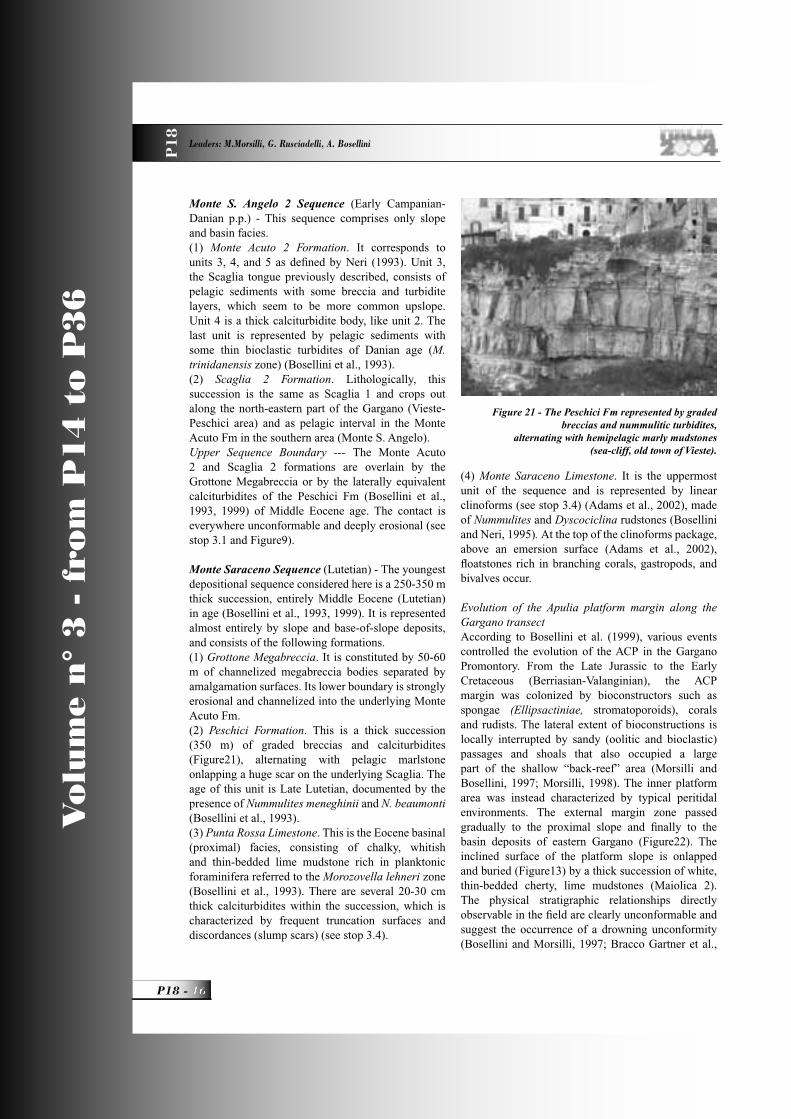
Figure 21 - The Peschici Fm represented by graded breccias and nummulitic turbidites,
alternating with hemipelagic marly mudstones (sea-cliff, old town of Vieste).
P18_R_OK 16 25-05-2004, 14:43:00
THE APULIA CARBONATE PLATFORM-MARGIN AND SLOPE, LATE JURASSIC TO EOCENE OF THE MAIELLA MT. AND GARGANO PROMONTORY:
PHYSICAL STRATIGRAPHY AND ARCHITECTURE P1
8
17 - P18
Vo
lum
e n
° 3
- f
rom
P1
4 t
o P
36
2002). After a period (Valanginian p.p.-Aptian p.p.) of normal platform and margin productivity and evolution, the ACP margin and the adjacent slope suddenly became inactivate during the early Aptian (Cobianchi et al., 1997; Bosellini et al., 1999). This event coincides with a relatively abrupt change in the open marine setting: the pelagic coccolith-rich white lime mudstones and chert of the Maiolica 2 Fm are overlain by the Marne a Fucoidi Fm, a marly and shaly succession, with episodic organic carbon-rich black shales (Cobianchi et al., 1997, 1999). The black shales correspond to a well known anoxic event occurred on a global scale and related to a change in the oceanographic and climatic conditions (Schlanger and Jenkyns, 1976; Jenkyns, 1980). Toward the end of the Albian and during the Cenomanian, a series of relative sea-level lowstands repeatedly exposed the carbonate platforms of the Southern Apennines and of the Apulian foreland to subaerial conditions, from the Maiella Mountain (Accarie et al., 1989; Eberli et al., 1993), to Lazio and Campania (Crescenti and Vighi, 1970; D’Argenio et al., 1987; Carannante et al., 1992; Ruberti, 1993), Gargano and Murge (Crescenti and Vighi, 1964; Mindszenty et al., 1995). The associated stratigraphic hiatuses, also documented by well-known bauxite deposits (D’Argenio and Mindszenty, 1991, 1992), are confi ned between the Albian p.p. and the early Turonian p.p. time interval. In the Gargano area, pronounced margin failures and consequent deposition of huge megabreccia bodies along the slope and base-of-slope belt were coeval with the general emergence and karst development of the southern Apennine carbonate platforms and also other platforms around the world (Grötsch et al., 1993). However, according to Crescenti and Vighi (1964), the bauxite-related unconformity of Gargano is late Cenomanian-Turonian p.p. (see
discussion in Bosellini et al., 1999, pp. 1248-1249). The triggering mechanisms of the Gargano collapses might be related to seismic shocks associated with the incipient uplift of Apulia (linked to migration of intraplate stress according to Mindszenty et al., 1995), which culminated with its generalized emersion in Cenomanian-Turonian times. According to seismic profi les, it seems possible that the entire ACP margin was indented by several scallop features (Figure2). From Turonian until the late Santonian the margin was reactivate, the deep scallops sutured and exportation of bioclastic deposits (Monte Acuto Fm) continued through this time interval. Another stop in the exportation along the slope of platform-derived sediments occurs in the late Santonian-Early Campanian (Luciani and Neri, 1994). At least 50 m of pelagic lime mudstones with cherts divide in two parts the Monte Acuto Fm. Recently, in the Apricena area, pelagic sediments of Late Santonian age (Dicarinella asymetrica Zone), have been documented on top of previous inner platform facies of the Altamura Limestone (Morsilli et al., 2003). A signifi cant landward retreat of the margin of the ACP during early Campanian times is also recorded in the Fasano-Ostuni area, some 200 km to the southeast (Murge, Figure2) (Pieri and Laviano, 1989;) and in the Adriatic offshore (De Alteriis and Aiello, 1993). This events testify the partial drowning of some sector of the ACP (Early Eocene?). Finally, in Paleocene? time, new catastrophic failures occurred on the margin of the Eocene platform. A basal megabreccia (Grottone Megabreccia) followed by Lutetian clinostratifi ed deposits of the Monte Saraceno Limestone and bioclastic turbidites (Peschici Fm) were deposited around (Vieste-Peschici area and Monte Saraceno) the Gargano Promontory.
Figure 22 - Late Jurassic-Early Cretaceous facies associations of the Gargano Promontory from the inner platform to the basin (modifi ed after Morsilli and Bosellini, 1997).
P18_R_OK 17 25-05-2004, 14:43:03
Vo
lum
e n
° 3
- f
rom
P1
4 t
o P
36
P18 -
Leaders: M.Morsilli, G. Rusciadelli, A. Bosellini
P1
8
Field itinerary
DAY 1Transfer from Florence to the Maiella Mt.
This day will be spent travelling from Florence to the Maiella Mt., along the A1 motor-way as far as Rome and along the A24 motor-way to Chieti (about 5 hours). From here we will reach the Mamma Rosa Hotel (about 1 hour), at about 2000 m, where we will have the dinner and spend the night.
DAY 2The Maiella Mountain
During this day, the geometric relationships between platform and slope-to-basin successions will be analysed, in order to reconstruct the type of margin that characterises the northern portion of the Apulia platform margin. Different geometric settings can be
seen at the seismic scale along the natural section of the Maiella (Stops 2.1 to 2.3). In the Pennapiedimonte area (Stop 2.4), about 90 My of geological evolution are “exposed” along a continuous, several hundred meters thick section. In fact, it records the stratigraphic history from the Late Cretaceous to the Miocene and the vertical transition from an escarpment-bounded platform to a carbonate ramp. The spectacular outcrops and the different elements recorded in the Maiella make this area one of the best case studies to observe geological features associated to a carbonate platform to basin transition.
Stop 2.1:The M. d’Ugni and Murelle panoramic viewWe are in front of the platform to basin transition, in the central area of the Maiella Anticline. The landscape corresponds to a natural section, east-west oriented, crosscutting the long axis of the anticline. Here, the depositional and geometric features of the northern
Figure 2.1.1 - Simplifi ed geological map of the central part of the Maiella Mountain. 1, Quaternary; 2, calcarenites of the S. Spirito Fm and Bolognano Fm p.p. ( Paleocene-Miocene); 3, skeletal sediments from open-shelf to ramp of the Orfento Fm (Campanian p.p.-Maastrichtian); 4, slope deposits of the Tre Grotte Fm (Turonian-Campanian p.p.); 5, slope deposits of the Valle dell’Inferno Fm (Cenomanian p.p.); 6, platform facies of the Morrone di Pacentro Fm (Early Cretaceous); 7, margin facies of the Cima Murelle Fm (Late Cretaceous); 8, main megabreccia bodies of the Tre Grotte Fm (Late Cretaceous); 9, traces of geological sections (modifi ed after Morsilli et al., 2002).
P18_R_OK 18 25-05-2004, 14:43:05
THE APULIA CARBONATE PLATFORM-MARGIN AND SLOPE, LATE JURASSIC TO EOCENE OF THE MAIELLA MT. AND GARGANO PROMONTORY:
PHYSICAL STRATIGRAPHY AND ARCHITECTURE P1
8
19 - P18
Vo
lum
e n
° 3
- f
rom
P1
4 t
o P
36
Figure 2.1.2 - The abrupt contact between the Lower Cretaceous platform and the Upper Cretaceous slope-to-basin sediments in the Monte D’Ugni area. Cliffs in the wood are thick megabreccia bodies that onlap the Lower Cretaceous
platform (see also Figure2.1.1). On the right, 3D reconstruction of the Monte d’Ugni area and the boundary between the two different facies (after Morsilli et al., in press).
Figure 2.1.3 - N-S cross section showing the escarpment geometry at Monte D’Ugni and the lithostratigraphic relationships between platform and slope formations. Note growth strata in the lower part of the Valle dell’Inferno Fm (after Rusciadelli et al., 2003).
Figure 2.1.4 - Panoramic view from north of the Cima delle Murelle-Monte Focalone area. The contact between slope and platform sediments are marked by the thick solid line.
P18_R_OK 19 25-05-2004, 14:43:07
Vo
lum
e n
° 3
- f
rom
P1
4 t
o P
36
P18 -
Leaders: M.Morsilli, G. Rusciadelli, A. Bosellini
P1
8
portion the ACP margin will be illustrated through seismic scale outcrops (Figure2.1.1). These features allow to reconstruct the complete evolution from an escarpment-bounded platform to a carbonate ramp and to evaluate the control of large-scale collapses on the physiography of the platform margin and on the architecture of the sedimentary successions.From the Rifugio Pomilio, looking southward, the Monte d’Ugni allows to observe a panoramic view of the eastern part of the Maiella platform margin. The sedimentary successions are represented from top to base by:- the Orfento Fm consisting of bioclastic prograding deposits of the Upper Cretaceous carbonate ramp;- the Tre Grotte Fm represented by the alternation between hemipelagic limestones, bio-calcarenites and megabreccias bodies (the cliffs between trees) of the Upper Cretaceous slope;- the Morrone di Pacentro Fm (the vertical, deep cliff)
representing the Lower Cretaceous inner platform succession; - the Valle dell’Inferno Fm represented by the alternation of biocalcarenites and megabreccia bodies of the Lower Cretaceous slope. In this area, the Upper Cretaceous slope deposits of the Tre Grotte Fm onlap the Lower Cretaceous inner platform facies through a low angle surface (Figure2.1.2). In cross section, this surface has an asymptotic profi le decreasing downslope from a 60° to 20°-10°, within a distance of 2.5 km (Figure2.1.3).
Figure 2.1.5 - 3D view of Cima delle Murelle-Monte Focalone area clearly shows the contact between the two different depositional environments (the view is from the
west) (after Morsilli et al., in press).
Figure 2.1.6 - N-S cross section showing the escarpment geometry along the Cima delle Murelle transect and the relationships between platform and slope deposits (after Morsilli et al., 2002).
Figure 2.1.7 - Clinoforms (around 30°) at the base of the Selva Romana Valley. Clinoforms are composed of
alternating bio-intraclstic grainstones, rudstones and breccias.
P18_R_OK 20 25-05-2004, 14:43:10
THE APULIA CARBONATE PLATFORM-MARGIN AND SLOPE, LATE JURASSIC TO EOCENE OF THE MAIELLA MT. AND GARGANO PROMONTORY:
PHYSICAL STRATIGRAPHY AND ARCHITECTURE P1
8
21 - P18
Vo
lum
e n
° 3
- f
rom
P1
4 t
o P
36
In a more distal position, the high angle contact (~45°), between Upper Cretaceous slope deposits and Lower Cretaceous platform deposits, abruptly interrupts the platform northward extent. Along the Tre Grotte Valley, the lower strata of the Valle dell’Inferno Fm are dipping 30°-40° southward, whereas the upper strata are dipping 30° northward and onlap the paleoescarpment. This geometric relationships suggest the activity of a fault or of a fault system during the deposition of the Valle dell’Inferno Fm, as also suggested by minor faults post-dated by the upper part of this unit.A 2 km wide concave upward profi le results from cross sections oriented E-W in the M. D’Ugni area (Figure2.1.3). Onlapping Upper Cretaceous slope deposits display maximal thickness in the centre of the indentation (500-600 m), thinning progressively up to few tens of metres laterally and upslope.Moving westward, in the central sector of the platform margin, the Murelle area records a different stratigraphic and geometric setting, with respect to the M. d’Ugni. Here, in fact, the Upper Cretaceous margin of the Cima delle Murelle Fm lies unconformably above the Lower Cretaceous platform of the Morrone di Pacentro Fm. Upper Cretaceous slope deposits are still represented by the Tre Grotte Fm, but with less frequent megabreccia events. Moreover, the paleoescarpment is represented by a more regular
and steeper profi le, which rests generally constant with average angles of 30° (Figs.2.1.4, 2.1.5, 2.1.6). North of Le Murelle, the paleoescarpment is defi ned by the contact between Upper Cretaceous slope facies (Tre Grotte Fm) with angles of 10° to 25°, and Lower Cretaceous proximal slope deposits (Morrone di Pacentro Fm), represented by 30° dipping clinoforms. Upslope, the escarpment truncates, fi rst, Lower Cretaceous sub-horizontal platform margin facies and then Upper Cretaceous external platform deposits (Figure2.1.7).
Stop 2.2:The Monte Rotondo panoramic viewThe M. Rotondo area corresponds to the westernmost outcrops of the platform margin, where similar depositional and geometric features of the Monte d’Ugni and Murelle areas are displayed (Figure2.2.1, 2.2.2). Here, the Tertiary succession, represented by an Eocene p.p. carbonate ramp (the upper white bar) and an Oligocene p.p. coralgal reef (the uppermost cliff on top of Pesco Falcone), seals the Cretaceous successions through an important unconformity that records a long-term hiatus (Paleocene to Middle Eocene; Eberli et al., 1993). The Cretaceous succession is represented from top to base by: the Orfento Fm that overlies and onlaps the Cima delle Murelle Fm; the Tre Grotte Fm that onlaps the Cima
Figure 2.2.1 - The spectacular seismic-scale escarpment geometry at Monte Rotondo and the relationships between platform and slope successions.
P18_R_OK 21 25-05-2004, 14:43:13
Vo
lum
e n
° 3
- f
rom
P1
4 t
o P
36
P18 -
Leaders: M.Morsilli, G. Rusciadelli, A. Bosellini
P1
8
delle Murelle Fm and the Morrone di Pacentro Fm.The contact between Upper Cretaceous slope facies (Tre Grotte Fm) and Lower Cretaceous platform deposits (Morrone di Pacentro Fm) corresponds to a surface with angles of 25° to 35°, similar to the Murelle area. Upslope, the contact is between Upper Cretaceous slope deposits and Upper Cretaceous platform margin facies; the escarpment corresponds to a steeper surface with average of 60°, similarly to the Monte D’Ugni area (Figure2.2.3). However, the lack of platform facies laterally to the Monte Rotondo (Rava del Diavolo to the west and Rava della Sfi schia to the east), and the absence of faults with a relevant downthrow, suggest a more complex morphology of the escarpment as regards other areas.
Stop 2.3:Blockhaus. Summary of the previous stops, interpretation of the physiography and evolution of the Maiella platform marginFrom this point it is possible to appreciate the whole extent of the northern margin of the ACP, outcropping along the east-west oriented natural section of the Maiella anticline. This allows to summerize all the observations and informations of the previous stops, in order to fi gure the general physiography of the paleomargin and to speculate about its evolution.In summary, the contact between Upper Cretaceous slope successions (Tre Grotte Fm) and Lower to Upper Cretaceous platform and margin facies is
characterised by different geometries from east to west. In the Monte d’Ugni area, it is characterised by a low-angle contact between Upper Cretaceous slope deposits and Lower Cretaceous platform succession; Upper Cretaceous margin deposits are missing. In the Murelle area, the Upper Cretaceous slope succession onlaps, fi rst the Lower Cretaceous proximal slope to inner platform deposits and then the Upper Cretaceous margin deposits. Here, the paleoescarpment corresponds to a regular and steep profi le, with average angles of 30°. In the Monte Rotondo area, Upper Cretaceous slope deposits onlap the Lower Cretaceous platform and the Upper Cretaceous margin through a surface with angles varying upward from 25°/35° to 60°.To better evaluate the morphologic features and the evolution of the paleoescarpment, a 3D model was builded by removing the Upper Cretaceous slope deposits (Valle dell’Inferno and Tre Grotte Fms) and by reconstructing the Upper Cretaceous margin, eroded during the Quaternary (Figure 2.3.1). The different geometric confi gurations of the
Figure 2.2.2 - 3D view of the area between Monte Focalone and Monte Rotondo and relative boundaries of slope and platform deposits (after Morsilli et al., in press). Figure 2.2.3 - N-S cross section showing the escarpment
geometry along Monte Rotondo area (for the location see Figure2.1.1 section I-I’) and the relationships between
platform and slope deposits. E-W geological section between Pesco Falcone and Cima delle Murelle area
(for the location see Figure2.1.1 section L-L’); note the presence of two large-scale scallops located east and west
of Monte Rotondo. Dotted lines indicate the interpreted reconstruction of the platform upslope (after Morsilli et
al., 2002).
P18_R_OK 22 25-05-2004, 14:43:16
THE APULIA CARBONATE PLATFORM-MARGIN AND SLOPE, LATE JURASSIC TO EOCENE OF THE MAIELLA MT. AND GARGANO PROMONTORY:
PHYSICAL STRATIGRAPHY AND ARCHITECTURE P1
8
23 - P18
Vo
lum
e n
° 3
- f
rom
P1
4 t
o P
36
paleoescarpment observed throughout the Maiella anticline suggest the presence of a complex sinuous platform margin. It is characterised by an alternation between deep indentations (Monte d’Ugni, Rava del Diavolo and Rava della Sfi schia), and prominent ridges (Murelle and Monte Rotondo and Pesco Falcone). The resultant morphology is a sort of giant groove and spur structure.Indentations are similar in shape and size to those observed in modern scalloped platform margins. They are incised on Lower Cretaceous platform (Morrone di Pacentro Fm) and fi lled by Upper Cretaceous slope facies (Tre Grotte Fm). Typical morphological features of landslides, such as crown, head scarp, fl anks and slip plane, can be easily recognized in the Monte d’Ugni indentation (Figure2.3.2). In prominent ridge structures, the erosional processes are less pronounced and the Lower Cretaceous platform is more preserved below the onlap.
The evolution of the paleoescarpmentThe 3D reconstruction points out two main features: the processes responsible for the complex confi guration of the platform margin and the role of the inherited morphology in the distribution of the Upper Cretaceous rudist-dominated margin.The complex morphology of the platform margin of the Maiella, resulting in the alternating between
large-scale indentations and prominent ridge structures, suggests the presence of large-scale collapses of the platform margin (Morsilli et al., 2000; 2002; Rusciadelli et al., 2003). This phenomenon profoundly modifi ed the original confi guration of the platform margin. In spite of this, along prominent ridge structures, some of the original geometric and depositional features are still preserved (e.g., Lower Cretaceous margin facies and margin to proximal
Figure 2.3.1 - Extended 3D model of the Maiella platform. This three-dimensional view allows to easily identifi ed a complex scalloped bank margin with scars of different shape and scale. Only in the Murella area the escarpment has
a regular and planar profi le. The red line marks the contact between the Lower and Upper Cretaceous platform facies (after Morsilli et al., in press).
Figure 2.3.2 - 3D model of the amphitheatre-like scar of the Monte D’Ugni area
P18_R_OK 23 25-05-2004, 14:45:00
Vo
lum
e n
° 3
- f
rom
P1
4 t
o P
36
P18 -
Leaders: M.Morsilli, G. Rusciadelli, A. Bosellini
P1
8
slope clinostratifi ed deposits) (Rusciadelli et al., 2003), and the pre-collapse depositional profi le of the platform-to-basin transition can be envisaged (Figure2.3.3). The reconstruction of the possible pre-collapse depositional profi le of the Maiella platform margin at the end of the Early Cretaceous suggests that the platform edge extended 1 km further to the north, compared with the present position of the paleoescarpment. The maximum thickness of the sediments eroded by the margin collapse is estimated around 300 m (Rusciadelli et al., 2003).The presence of large and small-scale scalloped structures and of breccias and megabreccias deposits, intercalated in slope successions during two distinct time intervals, suggests that the present escarpment confi guration was the result of two main evolution phases dominated by collapse events (Figure2.3.4). The fi rst one occurred between the Middle Albian and the Lower Cenomanian, as suggested by the
age of megabreccias with platform derived clasts outcropping northward (Bocca di Valle unit), and is defi ned by a major collapse event which affected the platform margin along its whole length. The previous physiography of the margin was deeply modifi ed, and for the fi rst time during the Cretaceous the platform to basin transition corresponds to an erosive and by-pass slope. The inherited confi guration was characterised by prominent ridges with an average 30° dipping stable slope, and by indentations with a less stable slope, affected by periodic different-scale collapses. These were responsible for the progressive backstepping of the platform edge. During this phase, large amounts of breccias, megabreccias and bioclastic deposits were shed basinward over distances of 15 km as average from the platform edge and distributed over an area of 150 km2 at least. Concomitantly to this phase, or immediately after, a widespread emersion of the platform occurred followed by
Figure 2.3.3 - Reconstructed geometry of the pre-collapse depositional profi le of the Maiella platform at the end of the Early Cretaceous. Following this reconstruction, the pre-collapse depositional profi le corresponds to a depositional and essentially aggrading or weakly prograding platform with a slope inclined about 25-30°.
P18_R_OK 24 25-05-2004, 14:39:35
THE APULIA CARBONATE PLATFORM-MARGIN AND SLOPE, LATE JURASSIC TO EOCENE OF THE MAIELLA MT. AND GARGANO PROMONTORY:
PHYSICAL STRATIGRAPHY AND ARCHITECTURE P1
8
25 - P18
Vo
lum
e n
° 3
- f
rom
P1
4 t
o P
36
Figure 2.3.4 - Interpretation of the origin and evolution of the Maiella paleoescarpment during the Albian p.p.-Campanian p.p. time interval (after Morsilli et al., 2002).
P18_R_OK 25 25-05-2004, 14:39:39
Vo
lum
e n
° 3
- f
rom
P1
4 t
o P
36
P18 -
Leaders: M.Morsilli, G. Rusciadelli, A. Bosellini
P1
8
the formation of bauxitic soils. The second phase, dominated by collapse events, started from Middle Cenomanian, in concomitance with the fl ooding of the platform previously emerged. Rudist biostromes and sand shoals newly colonised the platform margin, following the indented morphology of the platform edge, inherited by the previous large-scale collapse events. The presence of a steep escarpment prevented the basinward progradational of the margin, which aggraded vertically on the platform edge. Large amounts of bioclastic material, which indicates high productivity rates of the margin, were shed basinward by-passing the slope. This confi guration of the slope promoted small-scale collapses of margin portions during the Late Cretaceous, with the consequent progressive backstepping and reworking of the platform edge. The products of these small-scale collapses correspond to the breccias and megabreccias deposits intercalated within the Upper Cretaceous slope succession. During this phase, the space in front of the platform margin was progressively fi lled and conditions along the slope changed from by-pass to depositional.Many triggering mechanisms have been invoked to explain margin collapses and the formation of steep escarpments and their related products (i.e. megabreccias). The most widely accepted factors include: tectonically driven earthquake, fault scarp formation, platform oversteepening, thrust loading, undercutting bottom currents, differences in geotechnical behaviour of rocks, relative sea level
changes, and bolide impacts (see discussion in Spence and Tucker, 1997; Bosellini, 1998; Drzewiecki and Simo, 2002). To better understand the mechanisms triggering margin collapses, a quantitative modelling has been applied to the large-scale collapse of the Maiella Platform (Rusciadelli et al., 2003). The results obtained strengthen the hypothesis that the paleoescarpment is caused by a series of large-scale collapses associated to earthquake swarms linked to the tectonic displacement along a fault located at base of the slope. Successively to the issue of these results, direct fi eld data have carried new evidences for the presence of a fault, which activity was post-dated by Upper Cretaceous deposits (Figure 2.1.3).
Stop 2.4:Pennapiedimonte. The Upper Cretaceous to Miocene slope to distal ramp successionsThe Pennapiedimonte section is located on the eastern fl ank of the Maiella anticline, along the northern side of the Tre Grotte Valley (Figure2.4.1). Along this section the whole Cenomanian p.p. to Miocene slope-to-distal ramp succession is exposed (Figure 2.4.2). The Tertiary deposits are represented by the Bolognano (Chattian- Lower Messinian p.p.) and the Santo Spirito (Danian-Lower Rupelian) formations. The Bolognano Fm corresponds to a distal ramp with bioclastic sandwaves with large benthic foraminifera and molluscs. At the base, an erosive conglomerate, marked by a long-term hiatus, separates the Bolognano from the underlying S. Spirito Fm. In the
Figure 2.4.1 - Geological map of the Pennapiedimonte area
P18_R_OK 26 25-05-2004, 14:39:42
THE APULIA CARBONATE PLATFORM-MARGIN AND SLOPE, LATE JURASSIC TO EOCENE OF THE MAIELLA MT. AND GARGANO PROMONTORY:
PHYSICAL STRATIGRAPHY AND ARCHITECTURE P1
8
27 - P18
Vo
lum
e n
° 3
- f
rom
P1
4 t
o P
36
Pennapiedimonte section, this formation corresponds to a less prominent interval made up of calcareous bioclastic turbidites and pelagic limestones, with nummulitic debris fl ows intercalated at different stratigraphic levels. At the base, a few meter thick conglomerate separates the S. Spirito Fm from the underlying Orfento Fm. This represents the last Cretaceous depositional unit that seals the morphologic differences between the platform and the basin, across the Maiella escarpment. It is characterized by about 200 m of bioclastic grainstones and rudstones, organised into staked convex bodies (submarine sand waves), some hundred of meters long and few tens of meters thick. Megabreccias deposits locally occur at different stratigraphic level within the Orfento Fm. Along the Pennapiedimonte section, the lower boundary of this unit corresponds to an erosive unconformity highlighted by the abrupt change from coarse bioclastic grainstones and rudstones to pelagic and fi ne grained limestones of the underlying unit. Basinward, this boundary corresponds to a correlative conformity and the depositional features change gradually from one unit to another.
The underlying unit is the Tre Grotte Fm, defi ned by the alternation of centimetre to decimetre thick coarse to fi ne bioclastic packstones, pelagic planktonic foraminifera-rich mudstones and wackestones, rose and black chert levels. Metre to few tens of metres thick breccias and megabreccias bodies Figure 2.4.2 - Schematic stratigraphic section of the
Pennaiedimonte
Figure 2.4.3 - Photo along the Pennapiedimonte path. Here is exposed the upper part of the Tre Grotte Fm and
the Orfento Fm. Note the thick megabreccia bed along the road.
P18_R_OK 27 25-05-2004, 14:39:44
Vo
lum
e n
° 3
- f
rom
P1
4 t
o P
36
P18 -
Leaders: M.Morsilli, G. Rusciadelli, A. Bosellini
P1
8
characterise the section along the whole thickness. In the Pennapiedimonte area the Tre Grotte Fm is 500 m thick, but it rapidly thins southward, along the paleoescarpment. At the base of the unit, (Figure2.4.3) a few metres to 20 m thick interval of fi ne grained bioclastic packstones and pelagic mudstones, characterises the transition to the underlying Valle dell’Inferno Fm. This is the lowermost unit outcropping along the Pennapiedimonte section and it is composed by bioclastic grainstones and packstones, with several breccias and megabreccias bodies. The maximum outcropping thickness is about 300 m.
DAY 3Gargano Promontory
This day is dedicated to the erosional contact between the Peschici Fm (Middle Eocene) and the underlying Scaglia Fm (Coniacian p.p.) cropping out along the sea-cliff of Vieste town (Stop 3.1). Then we will observe the eastern coast of the Gargano Promontory where Lower Cretaceous basinal sediments, characterized by spectacular slumpings and breccia dykes, crops out along sea-cliffs (Stop 3.2). Coming westward, near Mattinata we shall observe the platform slope onlapped by the cherty lime mudstones of the Maiolica Fm (Stop 3.3). Finally, we will visit the Monte Saraceno area where a Middle Eocene slope-to-basin transition is very well exposed (Stop 3.4).
Stop 3.1:The Peschici Formation and its erosional contact with the underlying Scaglia Formation
On the southern sea-cliff of Vieste (near Pizzomunno spike), the erosional contact between the basinal, cherty lime mudstones of the Scaglia Fm and the overlying Peschici Fm is spectacularly exposed (Figure3.1.1). In this area the Peschici Fm is represented by meter-thick coarse calciturbidites (Figure21), rich in large nummulitids, alternating with “chalky” lime mudstones and fi ne-grained calcarenites, locally affected by heavy bioturbation (Figure3.1.2). The upper part of the Scaglia has been dated to the Marginotruncana sigali and Dicarinella primitiva zones (late Turonian-early Coniacian), whereas the Peschici Fm has been assigned to the middle Lutetian on the basis both of resedimented nummulites found in the bioclastic turbidites and of the
Figure 3.1.1 - Erosional contact (marine onlap) between the Peschici Fm and the underlying Scaglia Fm (Pizzomunno spike - Vieste).
Figure 3.1.2 - Burrows in the pelagic sediments of the Peschici Formation (S. Francesco – Vieste).
P18_R_OK 28 25-05-2004, 14:39:47
THE APULIA CARBONATE PLATFORM-MARGIN AND SLOPE, LATE JURASSIC TO EOCENE OF THE MAIELLA MT. AND GARGANO PROMONTORY:
PHYSICAL STRATIGRAPHY AND ARCHITECTURE P1
8
29 - P18
Vo
lum
e n
° 3
- f
rom
P1
4 t
o P
36
planktonic foraminifers (Turborotalia possagnoensis Zone) occurring in the intercalated pelagic mudstones (Bosellini et al., 1993). The unconformity separating the Eocene deposits from the underlying deep-water Cretaceous Scaglia Fm is not a transgressive contact, as interpreted previously, but a submarine erosional scar onlapped by gravity-displaced and pelagic sediments (Bosellini et al., 1993, 1999, 2000). These data indicate a major unconformity, associated with an erosional hiatus of about 45 Myr, between the
two units. Therefore, this hiatus is more pronounced basinward. It is not clear which mechanisms were involved in the formation of this gap, but a huge slump scar or prolonged activity of deep-sea currents could explain this contact (Bosellini et al., 1993).
Stop 3.2: The Lower Cretaceous Maiolica Formation and its slump structuresThe typical basinal deposits adjacent to the ACP carbonates are represented by the well-known Maiolica Fm (Figure3.2.1). It consists of white, thin-bedded, micritic limestones with chert, rich in calpionellids and nannoconus (Figure3.2.2). Various types of synsedimentary deformations affect the Maiolica Fm. Several slump features and “sedimentary dykes”
Figure 3.2.1 - Typical Maiolica outcrop: thin-bedded, white lime mudstones with chert lenses and layers, in places with slump features (Testa del Gargano).
Figure 3.2.2 - Black chert nodules in the Maiolica Formation (Torre del Ponte).
Figure 3.2.3 - Breccia dyke with Tertiary clasts within the Lower Cretaceous Maiolica Fm (Torre del Ponte).
P18_R_OK 29 25-05-2004, 14:39:51
Vo
lum
e n
° 3
- f
rom
P1
4 t
o P
36
P18 -
Leaders: M.Morsilli, G. Rusciadelli, A. Bosellini
P1
8
Figure 3.2.4 - Huge “megabreccia dyke” whitin the Maiolica Fm. Many clasts belong to the Maiolica (sea-cliff of Vignanotica cove).
Figure 3.2.5 - Sedimentary features of breccia dyke in the Maiolica Fm. The height of this outcrop is about 15 m
(Testa del Gargano).
Figure 3.2.6 - One of the most spectacular slumpings in the eastern Gargano (Baia delle Zagare).
P18_R_OK 30 21-06-2004, 9:08:53
THE APULIA CARBONATE PLATFORM-MARGIN AND SLOPE, LATE JURASSIC TO EOCENE OF THE MAIELLA MT. AND GARGANO PROMONTORY:
PHYSICAL STRATIGRAPHY AND ARCHITECTURE P1
8
31 - P18
Vo
lum
e n
° 3
- f
rom
P1
4 t
o P
36
(Figure3.2.3, 3.2.4, 3.2.5) are spectacularly exposed along coastal road cuts between Vieste and Mattinata and in various sea-cliffs along the coast. One of the most typical (and photographed) slumping occurs in the Baia delle Zagare cove (Figure3.2.6).
Stop 3.3:The depositional slope of the Apulia PlatformThe slope of the ACP (Upper Jurassic-Lower Cretaceous) onlapped by the Lower Cretaceous Maiolica Fm (drowning unconformity) is well exposed near the town of Mattinata (Figure13). According to Bosellini and Morsilli (1997), the age of the platform fl ank carbonates is Tithonian-Valanginian p.p., whereas the onlapping pelagic succession (Maiolica) is early Valanginian at the toe of the slope (Calpionellites Zone) and progressively younger upward (latest Valanginian-early Hauterivian; subzone NC4a of Bralower, 1987) (Figure3.3.1). No evidences of impregnation of authigenic minerals, like phosphate, glauconite,
and Fe-Mn crusts, commonly found associated with drowning surfaces in other areas of the Tethyan domain, are present (Föllmi et al., 1994). The Maiolica interval, close to the unconformity surface, contains several beds of densely packed isooriented
Figure 3.3.1 - The massive fl ank of the platform (Ripe Rosse Fm) onlapped by pelagic lime mudstones (Maiolica Fm) (Incoronata).
Figure 3.3.2 - Silicifi ed brachiopod shell (Peregrinella garganica).
P18_R_OK 31 25-05-2004, 14:39:58
Vo
lum
e n
° 3
- f
rom
P1
4 t
o P
36
P18 -
Leaders: M.Morsilli, G. Rusciadelli, A. Bosellini
P1
8
brachiopods (Peregrinella) (Figure3.3.2). According to Posenato and Morsilli (1999), Peregrinella habitats were situated below the photic zone and their food chain was based on chemoautotrophic bacteria. This would confi rm the proposal of Campbell and Bottjer (1995) to consider Peregrinella as a member of fossil cold-seep assemblages. The mass occurrence of Peregrinella in the Mattinata area could be related to the existence of methane (?) seepage, which rose from deep fractures or faults affecting the Lower Cretaceous platform fl ank.
Stop 3.4:The middle Eocene clinoforms and the transition to coeval basin depositsThis stop comprises a panoramic view of the whole
succession, quite well exposed in the sea-cliff of Punta Rossa and Monte Saraceno area (Figure3.4.1), as well as close observation of the main sedimentary facies. Starting from the sea level, the succession consists of the following units (Bosellini and Neri, 1995; Adams et al., 2002). A) Thin bedded fi ne-grained calcarenites alternating with minor chalky lime mudstones (Punta Rossa Limestone); a gradually increase in grainy lithotypes occurs upward. Frequent intraformational discordances (slump scars) are also visible in this unit (Figure3.4.2). B) Thick bedded, very fi ne to coarse sand sized, poorly washed skeletal packstones, grainstones, and rudstones with nummulitids, echinoids and other skeletal grains This clinostratifi ed slope deposits have a modal angle of 15–22.5° and a linear shape (Adams et al., 2002) (Figure3.4.3). C) Above an exposure surface, a massive limestone rich in branching corals, gastropods, and bivalves occur (Figure3.4.3).
DAY 4Gargano Promontory
During this day, the erosional margin of the ACP will be visited. In particular, the abrupt contact between the Lower Cretaceous platform deposits pertaining to the M. Spigno Fm and the gravity-displaced deposits of the Monte S. Angelo Fm will be examined (Stop 4.1). Next, we will have a panoramic view of the southern fl ank of the Carbonara Valley where an almost complete transect between Lower Cretaceous platform margin facies (Monte degli Angeli Limestone) and slope deposits crops out along the road to Monte S. Angelo (Stop 4.2). In the upper part of the section is also visible the huge megabreccia body of the Monte S. Angelo Fm that lies with an erosional contact on the previous
Figure 3.4.1 - The Monte Saraceno is consituted of Middle Eocene clinostratifi ed nummulitic calcarenites that passe downslope to the thinnely bedded basinal limestones of Punta Rossa Fm.
Figure 3.4.2 - Internal discordances (slump scars) in the sea-cliff of Punta Rossa.
P18_R_OK 32 25-05-2004, 14:40:01
THE APULIA CARBONATE PLATFORM-MARGIN AND SLOPE, LATE JURASSIC TO EOCENE OF THE MAIELLA MT. AND GARGANO PROMONTORY:
PHYSICAL STRATIGRAPHY AND ARCHITECTURE P1
8
33 - P18
Vo
lum
e n
° 3
- f
rom
P1
4 t
o P
36
succession. Later, some features of the Monte Acuto Fm will be examined (Stop 4.3). Finally, we will visit the CO.L.MAR quarry, where the peritidal cycles with many dinosaur footprints of the San Giovanni Rotondo Limestone crops out (Stop 4.4).
Stop 4.1a:Panoramic view of the scalloped marginThe large-scale stratigraphic relationships of the scalloped margin will be observed from the Manfredonia-Belvedere di Ruggiano road
Figure 3.4.3 - Clinostratifi ed thick beds with a planar surface. On top of the outcrop many coral rudstone to fl oatstone occur in a massive body of about 10-15 m above an exposure surface (Bosellini & Neri, 1995; Adams et al, 2002). This small “reef” could be the result of a relative sea-level lowstand and testify the only area where Eocene shallow-water carbonates crop out in the Gargano.
Figure 4.1.1 - Lateral relationships between the platform facies of the Monte Spigno Fm (MSF) and the Monte S. Angelo Fm (MSA). The unconformable surface separating the two units is a complex erosional surface onlapped by the megabreccia bodies of the Monte S. Angelo Fm and in the upper part by the thick calciturbidites of the Monte Acuto Fm
(SS – San Salvatore member). f, main faults; a-a’, trace of stratigraphic section of Figure 4.1.3 (after Bosellini et al., 1993, 2000).
P18_R_OK 33 25-05-2004, 14:40:04
Vo
lum
e n
° 3
- f
rom
P1
4 t
o P
36
P18 -
Leaders: M.Morsilli, G. Rusciadelli, A. Bosellini
P1
8
(Figure 4.1.1). The massive cliff of the Monte S. Angelo Fm (to the east) lies adjacent to platform deposits of Berriasian age of Monte Spigno Fm (to the west). The unconformable contact separating the two stratigraphic units is a complex erosional surface onlapped by the megabreccia bodies of the Monte S. Angelo Fm and in the upper part by the coarse-grained deposits of the Monte Acuto Fm (San Salvatore Member sensu Bosellini et al., 1993). This contact is instead considered a paleofault by several authors (Masse and Borgomano, 1987; Masse and Luperto Sinni, 1989; Borgomano, 2000; Graziano, 2000, 2001). However, detailed mapping of the area revealed that the contact line has a curvilinear shape (Figure 4.1.2) in plain view. Indeed, the various faults that dissect the areas result in mainly right-lateral displacement of the unconformable surface and are all younger than the surface itself. This area in a 3D reconstruction is a sort of kilometre-scale amphitheatre. Shape and dimension suggest the presence in this area of a scalloped bank margin, comparable to other features visible in the Maiella Mt. (see Day 2), and in many recent carbonate platforms of the Carribean region (Mullins et al., 1986; Hine et al., 1992).
Stop 4.1b:The section of the Belvedere di Ruggiano
This stop comprises close observations of the sedimentary features of the Monte S. Angelo Fm exposed in cuts along the road. In this section, (Figure 4.1.3) the platform deposits, belonging to the Monte Spigno Fm, are mainly represented by oolithic, oncolitic and bioclastic grainstones and bioturbated wackestone-packstone with gastropod shells and other bioclasts. They are dated as Berriasian on the basis of benthic foraminifers and calcareous algae (Bosellini et al., 1993). These shallow water carbonates are unconformably overlain by gravity-displaced deposits consisting of alternating megabreccia bodies (Figure4.1.4) and coarse calcarenites referred to the upper part of the Monte S. Angelo Fm (Figure 4.1.5).
Figure 4.1.2 - Geological map of the San Salvatore – Ruggiano area showing the amphiteatre-like contact between the shallow-water sediments (AP) and the adjacent Monte S. Angelo Fm (MSA) and the overlying Monte Acuto Fm (SS) (after Bosellini et al., 1993).
Figure 4.1.3 - Stratigraphic section of the Monte S. Angelo Fm and the overlying San Salvatore member in
the Ruggiano area (after Bosellini et al., 1993).
P18_R_OK 34 21-06-2004, 9:09:14
THE APULIA CARBONATE PLATFORM-MARGIN AND SLOPE, LATE JURASSIC TO EOCENE OF THE MAIELLA MT. AND GARGANO PROMONTORY:
PHYSICAL STRATIGRAPHY AND ARCHITECTURE P1
8
35 - P18
Vo
lum
e n
° 3
- f
rom
P1
4 t
o P
36
They are in turn overlain by turbiditic amalgamated bio-calcarenites and breccias, with scattered lenses of pelagic mudstones of Turonian age (Bosellini et al., 1993) that mark the base of the Monte Acuto Fm (Figure4.1.3).
Stop 4.2:Panoramic view of Val Carbonara sectionThe stop provides a panoramic view of the southern fl ank of Val Carbonara, between Monte degli
Angeli and the town of Monte S. Angelo to the east (Figure4.2.1). The fl at-lying platform deposits of Monte degli Angeli, mainly consisting of rudist, coral and sponge boundstone, grade to the east (Madonna degli Angeli) into clinostratifi ed slope deposits, belonging to the Mattinata Fm (Bosellini et al., 1993; Luciani and Cobianchi, 1994). Further east (near the town of Monte S. Angelo), the slope deposits are truncated by the basal megabreccia of the Monte S. Angelo Fm (Figure4.2.2). The whole succession could be subdivided in two parts rich in resedimented beds (breccia and calciturbidites) separated by a wedge of pelagic lime mudstones of Aptian age belonging to the Marne a Fucoidi Fm (Figure4.2.3).
Stop 4.3: The lower part of the Monte Acuto FormationThe lowermost part of the Monte Acuto Fm (Figure4.3.1) is represented by a pelagic-dominated interval, about 10 m thick, mainly consisting of thin-bedded whitish lime mudstone with planktonic foraminifers of the Helvetoglobotruncana helvetica Zone (Turonian) (Luciani, 1993) (Figure4.3.2) that sharply cover the Monte S. Angelo Fm. Thin lenses and layers of chert occur in the middle part of the unit and thin bioclastic calciturbidites are intercalated in the upper part of the interval, recording the beginning of the carbonate production and exportation along the slope and base-of-slope settings. The pelagic interval is deeply truncated by a megabreccia body. The upward succession consists mainly of alternating calciturbidites beds, frequently organized into
Figure 4.1.4 - Platform derived olistolith in the lower part of the Monte S. Angelo Fm. The block is about 2 m long (road Manfredonia – Ruggiano).
Figure 4.1.5 - Onlap of coarse bioclastic grainstone to rudstone (interval b in Figure 4.1.3) over the basal megabreccia body in the Ruggiano section.
P18_R_OK 35 25-05-2004, 14:40:11
Vo
lum
e n
° 3
- f
rom
P1
4 t
o P
36
P18 -
Leaders: M.Morsilli, G. Rusciadelli, A. Bosellini
P1
8
coarsening-up sequences (Figure18) (Neri, 1993), and pelagic lime mudstone intervals.
Stop 4.4:Peritidal cycles and dinosaur footprintsA thick pile of inner platform facies crops out in the whole western part of the Gargano Promontory where this type of sedimentation have persisted with minor interruptions from the Callovian to the Santonian p.p. (Sannicandro Limestone, San Giovanni Rotondo Limestone, Altamura Limestone). Peritidal cycles are visible in the CO.L.MAR quarry near Borgo Celano (Figure4.4.1). They belongs to the member 2 of the San Giovanni Rotondo Limestone (Figure4.4.2). Many dinosaur footprints have been recently discovered in the same quarry (Gianolla et al., 2000). The footprints are mainly natural casts (Figure4.4.3).
Figure 4.2.1 - Panoramic view of the Monte degli Angeli - Val Carbonara area, few kilometres west of the Monte S. Angelo town.
Figure 4.2.2 - Metric clast in the megabreccia of Monte S. Angelo Fm (Monte S. Angelo).
Figure 4.2.3 - Reconstructed geologic profi le (from photograph and stratigraphic sections) between Monte degli Angeli and the town of Monte S. Angelo. The paleoslope, its connection with the platform margins (Monte degli Angeli), and the main wedge of Aptian lime mudstone (Marne a Fucoidi), subdividing the two Mattinata sequences, are clearly visible (modifi ed after Luciani and Cobianchi, 1994; Bosellini et al., 1999).
P18_R_OK 36 25-05-2004, 14:40:14
THE APULIA CARBONATE PLATFORM-MARGIN AND SLOPE, LATE JURASSIC TO EOCENE OF THE MAIELLA MT. AND GARGANO PROMONTORY:
PHYSICAL STRATIGRAPHY AND ARCHITECTURE P1
8
37 - P18
Vo
lum
e n
° 3
- f
rom
P1
4 t
o P
36
They are present in the lower part of Member 2 of this stratigraphic unit, where the occurrence of Campanellula capuensis permits to date this interval to late Hauterivian-early Barremian time (Claps et al., 1996). Footprints occur in an easily recognizable layer composed mainly of peloidal wackestone-packstone with a cap of very thin (2 mm) green clay in which the reptiles “passage” was impressed. This lithofacies lies on a 40 cm thick bed extremely bioturbated with burrows fi lled by green and pink clay (Figure4.4.4). Other footprints have been found on top of a different layer composed mainly of bioturbated wackestones with some emersion features on top (oxidation fi lms and locally black-pebbles). Preliminary study on footprints and short tracks testifi es the presence of middle to large-size bipedal dinosaurs, whit a foot length ranging from 15 to 40 cm. Some of the footprints can be attributed to theropods, others could be also theropodan or iguanodontian and sauropods.
The above described dinosaur evidence suggests that a considerable portion of the ACP was emergent and supported the dinosaurs population with food and fresh water. The ACP and the associated Adriatic block have been considered since the beginning of the last century as a nose, a promontory of the Africa continent (plate). But all the most recent paleotectonic reconstructions consider Apulia an independent Figure 4.3.1 - Simplifi ed stratigraphic column of the
Monte Acuto Formation (after Neri, 1993).
Figure 4.3.2 - The pelagic interval above the Monte S. Angelo Fm, abruptly overlain by gravity-displaced debrites. The erosional contact represents the downlap surface of the prograding depositional system of the Monte Acuto Fm (road
Manfredonia-Monte S. Angelo).
P18_R_OK 37 25-05-2004, 14:40:18
Vo
lum
e n
° 3
- f
rom
P1
4 t
o P
36
P18 -
Leaders: M.Morsilli, G. Rusciadelli, A. Bosellini
P1
8
Figure 4.4.1 - Panoramic view of the CO.L.MAR quarry (south of Borgo Celano). The meter-scale cyclic arrangement is the most striking feature of the San Giovanni Rotondo Limestone.
Figure 4.4.2 - Simplifi ed stratigraphic log of the San Giovanni Rotondo Limestone with the occurrence of the dinosaur footprints found in the CO.L.MAR quarry (Borgo Celano section) (after Claps et al. 1996).
Figure 4.4.3 - Tridactyl dinosaur footprints found in the CO.L.MAR quarry (Borgo Celano).
P18_R_OK 38 25-05-2004, 14:40:21
THE APULIA CARBONATE PLATFORM-MARGIN AND SLOPE, LATE JURASSIC TO EOCENE OF THE MAIELLA MT. AND GARGANO PROMONTORY:
PHYSICAL STRATIGRAPHY AND ARCHITECTURE P1
8
39 - P18
Vo
lum
e n
° 3
- f
rom
P1
4 t
o P
36
micro-continent, separated from Africa by a deep-water oceanic channel (Masse et al., 1993). However, the presence of a “continental” dinosaurs association (with large sauropods and large theropods like those in the Cretaceous of North America and Africa) in the nearby Adriatic-Dinaric carbonate platform (NE Italy, Slovenia and Croatia) (Dalla Vecchia, 1998), suggests at least a Hauterivian-Barremian connection with Africa. The decouplement of Adria from Africa and the individuation of the Apulia microplate could be more recent. A possible connection between Apulia and Africa has been suggested by Bosellini (2002). His review of geophysical and geological data of the Ionian Sea and surrounding areas leads to envisage the Late Jurassic –Early Cretaceous Ionian Sea region as a ‘‘cul-de-sac’’-type basin enclosed by shallow-water carbonate banks, connecting the ACP to Peloponnesus, northern Cyrenaica, Cyrene Seamount and Medina Ridge (Figure4.4.5). These banks were repeatedly and periodically exposed to subaerial conditions, and offered vast land areas for migration of dinosaurs. The conclusion of Bosellini review leads to consider Adria as a true African Promontory and the ACP as a sort of Florida Peninsula, attached to North Africa (Cyrenaica spur), subdividing the oceanic(?) ‘‘Mesozoic Mediterranean’’ into a western Ionian basin and an eastern Levantine basin.
AcknowledgementsFinancial support to A.B. and M.M. has been provided by COFIN 2000 – MM04093739 (grant to A. Bosellini).
References citedAccarie, H. (1988). Dinamique sedimentaire et structurale au passage plate-forme/bassin. Les facies carbonates cretaces et tertiaires: Massif de la Maiella (Abruzzes, Italie). Ecole des Mines de Paris, Mémoire Science de la Terre 5, 158.Accarie, H., Beaudoin B., Cussey R., Joseph P. and Triboulet, S. (1989). Dynamique sédimentaire et structurale au passage plate-forme/basin, les faciés carbonates Cretacés du massif de la Maiella (Abruzzes, Italie). Memorie Società Geologica Italiana 36 (1986), 217-231.Accordi, G., Carbone, F., Sirna, G., Catalano, G. and Reali, S. (1987). Sedimentary events and rudist assemblages of Maiella Mt. (Central Italy): paleogeographic implications. Geologica Romana, 26, 135-147. Roma.Adams, E.W., Morsilli, M., Schlager, W., Keim, L.
Figure 4.4.4 - Beds with peculiar sedimentologic features. Burrows are very well developed in the central part and fi lled by green or pink clay. The dinosaur footprints are present in the thin clay layer visible in the upper part (arrow).
Figure 4.4.5 - Paleogeographic map of the central-western Mediterranean area during the Early Cretaceous. The Ionian Sea basin is interpreted as a ‘‘cul-de-sac’’ deep sound foundered in Middle Jurassic time, contemporaneously with the opening of the Ligurian Ocean. The Apulia carbonate platform is considered a spur of the African platform, separating two deep-water basins, the Ionian to the west and the Levantine to the east. Location of mid-oceanic ridges and transform faults is hypothetical (after Bosellini, 2002).
P18_R_OK 39 21-06-2004, 9:09:40
Vo
lum
e n
° 3
- f
rom
P1
4 t
o P
36
P18 -
Leaders: M.Morsilli, G. Rusciadelli, A. Bosellini
P1
8
and Van Hoek, T. (2002). Quantifying the geometry and sediment fabric of linear slopes: examples from the Tertiary of Italy (Southern Alps and Gargano Promontory). Sedimentary Geology 154, 11-30.Bernoulli, D. (1972). North Atlantic and Mediterranean Mesozoic facies: a comparision. In “Initial Reports of the Deep Sea Drilling Project” (C.D. Hollister, J.I. Ewing et al. eds.), 11, pp. 801-871. Washington, D.C., U.S. Government Printing Offi ce.Bertotti, G., Casolari, E. and Picotti, V. (1999). The Gargano Promontory: a Neogene contractional belt within the Adriatic plate. Terra Nova 11, 168-173.Billi, A. and Salvini, F. (2000). Sistemi di fratture associati a faglie in rocce carbonatiche, nuovi dati sull’evoluzione tettonica del Promontorio del Gargano. Bollettino Società Geologica Italiana 119, 237-250.Billi, A. (2003). Solution slip and separations on strike-slip fault zones: theory and application to the Mattinata Fault, Italy. Journal of Structural Geology 25, 703–715.Borgomano, J.R.F. (2000). The Upper Cretaceous carbonates of the Gargano-Murge region, southern Italy: A model of platform-to-basin transition. A.A.P.G. Bulletin 84, 1561-1588.Bosellini, A. (1998). Scalloped vs faulted carbonate platform margins and the origin of basinal megabreccias. Bollettino Società Geologica Italiana 53, 63-74.Bosellini, A. (2002). Dinosaurs ‘‘re-write’’ the geodynamics of the eastern Mediterranean and the paleogeography of the Apulia Platform. Earth-Science Reviews 59, 211– 234.Bosellini, A. and Morsilli, M. (1994). Il Lago di Varano (Gargano, Puglia settentrionale): una nicchia di distacco da frana sottomarina cretacea. Annali Università di Ferrara (N.S.), Sezione Scienze della Terra 5, 39-52.Bosellini, A. and Morsilli, M. (1997). A Lower Cretaceous drowning unconformity on the eastern fl ank of the Apulia Platform (Gargano Promontory, southern Italy). Cretaceous Research 18, 51-61.Bosellini, A. and Neri, C. (1995). L’Eocene di Monte Saraceno (Promontorio del Gargano, Puglia). Annali Università di Ferrara (N.S.), Sezione Scienze della Terra 6, 27-40.Bosellini, A., Morsilli, M. and Neri, C. (1999). Long-term event stratigraphy of the Apulia Platform margin: Upper Jurassic to Eocene, Gargano, Southern Italy. Journal of Sedimentary Research 69, 1241-1252.Bosellini, A., Morsilli, M. and Neri, C. (2000). The
eastern margin of the Apulia Platform: the Gargano transect. In “Quantitative Models on Cretaceous Carbonate” S.E.P.M Cretaceous Resource Events and Rhythms, WG4 meeting, Vieste, Italy, fi eld trip guide book, 46 pp.Bosellini, A., Neri, C. and Luciani, V. (1993). Platform margin collapses and sequence stratigraphic organization of carbonate slopes: Cretaceous-Eocene, Gargano Promontory. Terra Nova 5, 282-297.Bracco Gartner, G., Morsilli, M., Schlager, W. and Bosellini, A. (2002). Toe-of-slope of a Cretaceous carbonate platform in outcrop, seismic model and offshore seimic data (Apulia, Italy). International Journal of Earth Science 91, 315-330. Bralower, T.J. (1987). Valanginian to Aptian calcareous nannofossil stratigraphy and correlation with the upper M-sequence Magnetic Anomalies. Marine Micropaleontology 11, 293-310.Campbell, K.A. and Bottjer, D.J. (1995). Peregrinella: an Early Cretaceous cold-seep-restricted brachiopod. Paleobiology 21, 461-478.Catenacci, V. (1974). Note illustrative della Carta Geologica d’Italia scala 1:100.000 - Foglio 147 “Lanciano”. Servizio Geologico d’Italia, 87 pp.Carannante, G., D’argenio B, Dello Iacovo B., Ferreri V., Mindszenty A. and Simone L. (1992). Studi sul carsismo cretacico dell’Appennino Campano. Memorie Società Geologica Italiana 41 (1988), 733-759.Chilovi, C., De Feyter, A.J. and Pompucci, A. (2000). Wrench zone reactivation in the Adriatic Block: the example of the Mattinata Fault System (SE Italy). Bollettino Società Geologica Italiana 119, 3-8.Ciarapica, G. and Passeri, L. (2002). The paleogeographic duplicity of the Apennines. Bollettino Società Geologica Italiana, Volume speciale 1, 67-75.Claps, M., Parente, M., Neri, C. and Bosellini, A. (1996). Facies and cycles of the S. Giovanni Rotondo Limestones (Lower Cretaceous, Gargano Promontory, Southern Italy): the Borgo Celano Section. Annali Università di Ferrara, Sezione Scienze della Terra 7, 1-35.Cobianchi, M., Luciani, V. and Bosellini, A. (1997). Early Cretaceous nannofossils and planktonic foraminifera from northern Gargano (Apulia, southern Italy). Cretaceous Research 18, 249-293.Cobianchi, M., Luciani, V. and Menegatti, A. (1999). The Selli Level of the Gargano Promontory, Apulia, southern Italy: foraminiferal and calcareous nannofossil data. Cretaceous Research 20, 255-269.
P18_R_OK 40 25-05-2004, 14:40:27
THE APULIA CARBONATE PLATFORM-MARGIN AND SLOPE, LATE JURASSIC TO EOCENE OF THE MAIELLA MT. AND GARGANO PROMONTORY:
PHYSICAL STRATIGRAPHY AND ARCHITECTURE P1
8
41 - P18
Vo
lum
e n
° 3
- f
rom
P1
4 t
o P
36
Colantoni, P., Tramontana, M. and Tedeschi, R. (1990). Contributo alla conoscenza dell’avampaese apulo: struttura del Golfo di Manfredonia. Giornale di Geologia 52, 145-162. BolognaCremonini, G., Elmi, C. and Selli, R. (1971). Note illustrative della carta geologica d’Italia, alla scala 1:100.000; Foglio 156 “S. Marco in Lamis”. Servizio Geologico d’Italia, pp. 66, Roma.Crescenti, U. and Vighi, L. (1964). Caratteristiche, genesi e stratigrafi a dei depositi bauxitici cretacici del Gargano e delle Murge; cenni sulle argille con pisoliti bauxitiche del Salento. Bollettino Società Geologica Italiana 83, 285-337.Crescenti, U. and Vighi, L. (1970). Risultati delle ricerche eseguite sulle formazioni bauxitiche cretaciche del Casertano e del Matese, in Campania. Memorie Società Geologica Italiana 9, 401-434.Crescenti, U., Crostella, A., Donzelli, G. and Raffi , G.(1969). Stratigrafi a della serie calcarea dal lias al miocene nella regione Marchigiano Abruzzese. (Parte II - Litostratigrafi a, biostratigrafi a, paleogeografi a). Memorie Società Geologica Italiana 9, 343-420.Crescenti, U., Milia, M. L. and Rusciadelli, G. (in press). Stratigraphic and tectonic evolution of the Pliocene Abruzzi basin (Central Apennines, Italy). Bollettino Società Geologica Italiana.D’Argenio, B. (1971). Evoluzione geotettonica comparata tra alcune piattaforme carbonatiche dei Mediterranei Europeo ed Americano. Atti Accademia Pontaniana 20, 331-362. Napoli.D’Argenio, B. and Mindszenty, A. (1991). Karst bauxites at regional unconformities and geotectonic correlation in the Cretaceous of the Mediterranean. Bollettino Società Geologica Italiana 110, 85-92.D’Argenio, B. and Mindszenty, A. (1992). Tectonic and climatic control on paleokarst and bauxites. Giornale di Geologia 54, 207-218. Bologna.D’Argenio, B., Mindszenty, A., Bardossy, G.Y., Juhasz, E. and Boni, M. (1987). Bauxites of southern Italy revisited. Rendiconti Società Geologica Italiana 9, 263-268.Dalla Vecchia, F.M. (1998). Remains of Sauropoda (Reptilia, Saurischia) in the Lower Cretaceous (Upper Hauterivian/Lower Barremian) limestones of SW Istria (Croatia). Geologica Croatica 51, 105-134. Zagreb.De Alteriis, G. and Aiello, G. (1993). Stratigraphy and tectonics offshore of Puglia (Italy, southern Adriatic Sea). Marine Geology 113, 233-253.De Alteriis, G. (1995). Different foreland basins in Italy: examples from the central and southern Adriatic
Sea. Tectonophysics 252, 349–373. De Cosmo, P.D. and Morsilli, M. (2002). Segnalazione di resti di fl ora ed ittiofauna fossile del Santoniano superiore nell’area di Apricena (Puglia, Gargano). Gruppo informale di Sedimentologia, IX Riunione annuale, Pescara 21-22 Ottobre, Abstract book, 39-40.De Dominicis, A. and Mazzoldi, G. (1989). Interpretazione geologico-strutturale del margine orientale della Piattaforma Apula. Memorie Società Geologica Italiana 38 (1987), 163-176.Doglioni, C., Mongelli, F. and Pieri, P. (1994). The Puglia uplift (SE Italy). An anomaly in the foreland of the Apenninic subduction due to buckling of a thick continental lithosphere. Tectonics 13, 1309–1321.Donzelli, G. (1968). Studio geologico della Maiella. In: “Studio Geologico della Maiella”. Università Gabriele D’Annunzio, Dipartimento di Scienze della Terra (Ed.) (1997), 1-49.Drzewiecki, P.A. and Simo, J.A. (2002). Depositional processes, triggering mechanisms and sediment composition of carbonate gravity fl ow deposits: examples from the Late Cretaceous of the south-central Pyrenees, Spain. Sedimentary Geology 146,155-189.Eberli, G.P., Bernoulli, D., Sanders, D. and Vecsei, A. (1993). From aggradation to progradation: the Maiella Platform, Abruzzi, Italy.In “Cretaceous Carbonate Platform” (J.A.T. Simo, R.W. Scott and J.P. Masse eds.), A.A.P.G. Memoir 56, 213-232.Favali, P., Funiciello, R., Mattietti, G., Mele, G. and Salvini, F., 1992. An active margin across the Adriatic Sea (central Mediterranean Sea). Tectonophysics 219, 109–117.Finetti, I.R. (in press). Geodynamic evolution of the Meditteranean region from Permo-Triassic Ionian opening to present, constrained from new lithspheric CROP seismic data. Tectonophysics, Spec. Vol., Chapter 34.Finetti, I. and Del Ben, A. (1986). Geophysical study of the Tyrrhenian opening. Bollettino di Geofi sica Teorica ed Applicata 28, 75–155. Trieste.Finetti, I.R., Calamita, F., Crescenti, U., Rusciadelli G., Scisciani, V. (in press). Crustal geological section across Central Italy form the Corsica Basin to the Adriatic Sea based on geological and CROP seismic data. Tectonophysics, Spec. Vol.Föllmi K.B., Weissert H., Bisping M. and Funk H. (1994). Phosphogenesis, carbone-isotope stratigraphy, and carbonate-platform evolution along the Lower Cretaceous northern Tethyan margin. Geological
P18_R_OK 41 25-05-2004, 14:40:29
Vo
lum
e n
° 3
- f
rom
P1
4 t
o P
36
P18 -
Leaders: M.Morsilli, G. Rusciadelli, A. Bosellini
P1
8
Society of America Bulletin 106, 729-746.Funiciello, R., Montone, P., Salvini, F. and Tozzi, M. (1992). Caratteri strutturali del Promontorio del Gargano. Memorie Società Geologica Italiana 41 (1988), 861-868.Gambini, R. and Tozzi, M. (1996). Tertiary geodynamic evolution of the Southern Adria microplate. Terra Nova 8, 593-602.Ghisetti, L. and Vezzani, F. (2002). Normal faulting, extension and uplift in the outer thrust belt of the central Apennines (Italy): role of the Caramanico fault. Basin Research 14, 225-236.Gianolla, P., Morsilli, M. and Bosellini A. (2000). First discovery of Early Cretaceous dinosaur footprints in the Gargano Promontory. In “The eastern margin of the Apulia Platform: the Gargano transect” (Bosellini A., Morsilli M. and Neri C. eds.). Quantitative Models on Cretaceous Carbonate, WG4 meeting, Vieste, Italy, abstract, 9.Gradstein, F.M., Agterberg, F.P., Ogg, J.G., Hardenbol, J., Van Veen, P., Thierry, J. and Huang, Z. (1995). A Triassic, Jurassic and Cretaceous time scale. In “Geochronology, Time Scales and Global Stratigraphic Correlation” (W.A. Berggren, D.V. Kent, M.P. Aubry and J. Hardenbol eds.), S.E.P.M. Special Publication 54, 95-126.Graziano, R. (2000). The Aptian-Albian of the Apulia Carbonate Platform (Gargano Promontory, southern Italy): evidence of palaeogeographic and tectonic controls on the stratigraphic architecture of the platform margin. Cretaceous Research 21, 107-126.Graziano, R. (2001). The Cretaceous megabreccias of the Gargano Promontory (Apulia, southern Italy): their stratigraphic and genetic meaning in the evolutionary framework of the Apulia Carbonate Platform. Terra Nova 13, 110-116.Grötsch, J., Schroeder, R., Noe, S. and Flugel, E. (1993). Carbonate platforms as recorders of high-amplitude eustatic sea-level fl uctuations: the late Albian appenninica-event. Basin Research 5, 197-212.Guerricchio, A. (1986). Esempi di bacini di pull-apart nel Gargano. Geologia Applicata e Idrogeologia 21, 25-36. Bari.Guerricchio, A. (1996). Strutture di blocco (curve di imbottigliamento) lungo la faglia di Mattinata (Gargano). Geologia Applicata e Idrogeologia 31, 315-322. Bari.Hine, A., Locker, S.D., Tedesco, L.P., Mullins, H.T., Hallock, P., Belknap, D.F., Gonzales, J.L. Neumann, A.C. and Snyder, S.W. (1992). Megabreccia shedding
from modern, low-relief carbonate platforms, Nicaraguan Rise. Geological Society of America Bulletin 104, 928-943.Hubbard, R.J. (1988). Age and signifi cance of sequence boundaries on Jurassic and early Cretaceous rifted continental margins. A.A.P.G. Bulletin 72, 49-72.Jenkyns, H.C. (1980). Cretaceous anoxic events: from continents to oceans. Journal of the Geological Society, 137, 171-188.Laviano, A. and Marino, M. (1996). Biostratigraphy and paleoecology of Upper Cretaceous carbonate successions in the Gargano Promontory. Memorie Società Geologica Italiana 51, 685-701.Luciani, V. (1993). Paleoecology of Mid-Turonian planktic Foraminifera assemblages: an example of depth stratifi cation along a carbonate paleoslope (Gargano Promontory). Annali Università di Ferrara (N.S.), Sezione Scienze della Terra 4, 47-49.Luciani, V. and Cobianchi, M. (1994). Type section of the Mattinata Formation (Lower Cretaceous, Gargano Promontory, southern Italy): new biostratigraphic data (calcareous nannofossils and planktonic foraminifers). Memorie di Scienze Geologiche 46, 283-301. Padova.Luperto Sinni, E. (1996). Schema stratigrafi co del Cretacico del Gargano basato su risultati di recenti ricerche. Memorie Società Geologica Italiana 51, 1019-1036.Luperto Sinni E. and Borgomano J. (1994). Stratigrafi a del Cretaceo superiore in facies di scarpata di Monte S. Angelo (Promontorio del Gargano, Italia meridionale). Bollettino Società Geologica Italiana 113, 355-382.Luperto Sinni, E. and Masse, J.P. (1986). Données nouvelles sur la stratigraphie des calcaires de plate-forme du Crétacé inférieur du Gargano (Italie méridionale). Rivista Italiana di Paleontologia e Stratigrafi a 92, 33-66. Milano.Luperto Sinni, E. and Masse, J.P. (1987). Données nouvelles sur la stratigraphie et la micropaléontologie des séries carbonatées de talus et de basin du Crétacé inférieur du Gargano (Italie méridionale). Rivista Italiana di Paleontologia e Stratigrafi a 93, 347-378. Milano.Martinis, B. and Pieri, P. (1964). Alcune notizie sulla formazione evaporitica del Triasssico superiore nell’Italia centrale e meridionale. Memorie Società Geologica Italiana 4 (1963), 649-678.Masse, J.P. and Borgomano, J. (1987). Un modèle de transition plate-forme-bassin carbonatés contrôlé par
P18_R_OK 42 25-05-2004, 14:40:31
THE APULIA CARBONATE PLATFORM-MARGIN AND SLOPE, LATE JURASSIC TO EOCENE OF THE MAIELLA MT. AND GARGANO PROMONTORY:
PHYSICAL STRATIGRAPHY AND ARCHITECTURE P1
8
43 - P18
Vo
lum
e n
° 3
- f
rom
P1
4 t
o P
36
des phénomènes tectoniques: le Crétacé du Gargano (Italie Méridionale). C.R. Acad. Sc. Paris, t. 304, Série II, n° 10, 521-526.Masse, J.P. and Luperto Sinni, E. (1989). A platform to basin transitional model: the lower cretaceus carbonates of the Gargano Massif. Memorie Società Geologica Italiana 40 (1987), 99-108.Masse, J.P., Bellion, Y., Benkhelil, J., Boulin, J., Cornee, J.J., Dercourt, J., Guiraud, R., Mascle, G., Poisson, A., Ricou, L.E., Sandulescu, M. (1993). Lower Aptian (114 to 112 Ma). In “Atlas Tethys Palaeoenvironmental Maps” (Dercourt J., Ricou L.E. and Vrielync B. eds.), 135-152 (CCGM, Paris, 1993).Merla, G., Ercoli, A. and Torre, D. (1969). Note illustrative della carta geologica d’Italia, alla scala 1:100.000, Foglio 164 “Foggia”. Servizio Geologico d’Italia, 22 pp., Roma.Mindszenty, A., D’argenio, B. and Aiello, G. (1995). Lithospheric bulges recorded by regional unconformities. The case of Mesozoic-Tertiary Apulia. Tectonophysics 252, 137-161.Morsilli, M. (1998). Stratigrafi a e sedimentologia del margine della Piattaforma Apula nel Gargano (Giurassico superiore-Cretaceo infe-riore). Tesi di Dottorato di Ricerca, Università di Ferrara, 203 pp., Librerie Nazionali di Roma e Firenze.Morsilli, M. and Bosellini, A. (1997). Carbonate facies zonation of the Upper Jurassic-Lower Cretaceous Apulia Platform margin (Gargano Promontory, southern Italy). Rivista Italiana di Paleontologia e Stratigrafi a 103, 193-206. Milano.Morsilli, M., Rusciadelli, G., Vich,i G. and Bosellini, A. (2000). Gravity-driven processes: Control on margin architecture and slope evolution in a Cretaceous carbonate platform (Montagna della Maiella, Italy). A.A.P.G. Bulletin 84, Association Round Table abstract, 1467.Morsilli, M., Rusciadelli, G. and Bosellini, A. (2002). Large-scale gravity-driven structures: control on margin architecture and related deposits of a Cretaceous Carbonate Platform (Montagna della Maiella, Central Appennines, Italy). Bollettino Società Geologica Italiana, Volume Speciale n° 1, 619-628.Morsilli, M., Rusciadelli, G. and Milia, L. (in press). 3D reconstruction of a Cretaceous scalloped bank margin: The Apulia carbonate platform (Montagna della Maiella, Italy). Journal of Sedimentary Research.Morsilli, M., De Cosmo P.D., Luciani, V. and Bosellini, A. (2003). Late Santonian partial
drowning of the Apulia Carbonate Platform (Gargano Promontory, southern Italy): new data for paleogeographic reconstructions. 22nd I.A.S. Regional Meeting – Opatija, Croatia. Abstract Book, 135.Mostardini, F. and Merlini, S. (1986). Appennino centro-meridionale: sezioni geologiche e proposta di modello strutturale. AGIP Mineraria, Atti 73° Congresso Società Geologica Italiana, pp. 1-59.Mullins, H.T., Gardulski, A.F. and Hine, A.C. (1986). Catastrophic collapse of the west Florida carbonate platform margin. Geology 14, 167-170.Mutti, M., Bernoulli, D., Eberli, G. and Vecsei, A. (1996). Depositional geometries and facies associations in an Upper Cretaceous prograding carbonate platform margin (Orfento Supersequence, Maiella, Italy). Journal of Sedimentary Research 66, 749-765.Neri, C. (1993). Stratigraphy and sedimentology of the Monte Acuto Formation (Upper Cretaceous-Lower Paleocene, Gargano Promontory, Southern Italy). Annali Università di Ferrara (N.S.), Sezione Scienze della Terra 4, 13-44.Neri, C. and Luciani, V. (1994). The Monte S. Angelo Sequence (Late Cretaceous - Paleocene, Gargano Promontory, southern Italy): physical stratigraphy and biostratigraphy. Giornale di Geologia 56, 149-165. Bologna.Ortolani, F. and Pagliuca, S. (1989). Tettonica transpressiva nel Gargano e rapporti con le catene appenninica e dinarica. Memorie Società Geologica Italiana 38 (1987), 205-224.Patacca, E., Scandone, P., Bellatalla, M., Perilli, N. & Santini U., 1991. La zona di giunzione tra l’arco appenninico settentrionale e l’arco appenninico meridionale nell’Abruzzo e nel Molise. Studi Geologici Camerti, Vol. Speciale, 1991/2, CROP 11, 417-441. Camerino.Pieri, P. and Laviano, A. (1989). Tettonica e sedimentazione nei depositi Senoniani delle Murge sud-orientali (Ostuni). Bollettino Società Geologica Italiana 108, 351-356.Posenato, R. and Morsilli, M. (1999). New species of Peregrinella (Brachiopoda) from the Lower Cretaceous of the Gargano Promontory (southern Italy). Cretaceous Research 20, 641-654.Posenato, R., De Fino, M., La Volpe, G. and Piccarreta, P. (1994). L’affi oramento del Trias superiore delle Pietre Nere (calcari e gessi) e i prodotti del vulcanesimo basico paleogenico. Società Geologica Italiana, 77 Riunione estiva. Guida all’escursione, 19-23. Bari.
P18_R_OK 43 25-05-2004, 14:40:32
Vo
lum
e n
° 3
- f
rom
P1
4 t
o P
36
P18 -
Leaders: M.Morsilli, G. Rusciadelli, A. Bosellini
P1
8
Ruberti, D. (1993). Le lacune stratigrafi che nel Cretacico del Matese centro-settentrionale. Bollettino Società Geologica Italiana 111 (1992), 283-289.Rusciadelli, G. (in press). Clastic shedding, pelagic intervals, breccias and megabreccias: the slope response to the Lazio-Abruzzi Platform dynamics. Journal of Sedimentary Research.Rusciadelli, G. and Vichi, G. (1998). Stratigrafi a sequenziale, organizzazione e correlazione dei depositi di piattaforma e bacino del Cretacico superiore della Maiella. “Atti del 79° Congresso Nazionale della S.G.I.” (Palermo).Rusciadelli, G., Sciarra, N. and Mangifesta, M. (2003). 2D modelling of large-scale platform margin collapses along an ancient carbonate platform edge (Maiella Mt., Central Apennines, Italy): geological model and conceptual framework. Palaeogeography, Palaeoclimatology, Palaeoecology 200, 189-203.Salvini, F., Billi, A. and Wise, D.U. (1999). Strike-slip fault-propagation cleavage in carbonate rocks: the Mattinata Fault zone, Southern Apennines, Italy. Journal of Structural Geology 21, 1731–1749.Sanders, D. (1996). Rudists biostromes on the margin of an isolated carbonate platform: the upper cretaceous of montagna della Maiella, Italy. Eclogae geologicae Helvetiae 89, 845-871.Schlager, W. (1989). Drowning unconformities on carbonate platforms. In “Controls on Carbonate Platform and Basin Development” (Crevello P.D., Wilson J.L., Sarg J.F. and Read J.F. eds), S.E.P.M. Special Publication 44, 15-25.Schlanger, S. O. and Jenkyns, H. C. (1976). Cretaceous
oceanic anoxic sediments: causes and consequences. Geologie en Mijnbouw 55, 179-184.Scisciani, V., Calamita, F., Bigi, S., De Girolamo, C. & Paltrinieri, W., 2000. The infl uence of syn-orogenic normal faults on Pliocene thrust system development: the Maiella structure (Central Apennines, Italy). Memorie Società Geologica Italiana 55, 193-204.Spence, G.H. and Tucker, M.E. (1997). Genesis of limestone megabreccias and their signifi cance in carbonate sequence stratigraphic models: a review. Sedimentary Geology 112, 163-193.Stössel, I. (1999). Rudists and carbonate platform evolution: the Late Cretaceous Maiella Carbonate Platform Margin, Abruzzi, Italy. Memorie di Scienze Geologiche 51, 333-413. Padova.Vail, P.R., Audermard, F., Bowman S.C., Eisner, P.N. and Perez Cruz, G. (1991). The stratigraphic signature of tectonics and sedimentation: an overview. In “Cycles and Events in Stratigraphy” (G. Einsele, W. Ricken and A. Seilacher, eds.), Springer Verlag, 617-659. Berlin.Vecsei, A. (1991). Aggradation und progradation eines karbonatplattform-randes: kreide mis mittleres tertiar der montagna della Maiella, Abruzzen. Ph.D. Thesis, Mitteilungen des Geologischen Institutes der Eidgenossischen Technischen Hochschule und der Universitat, 274, 171 pp.Vezzani L. & Ghisetti F. (1997). Carta geologica dell’Abruzzo in scala 1:100000. S.E.L.C.A., Firenze.Zappaterra E. (1990). Carbonate paleogeographic sequence of the Periadriatic region. Bollettino Società Geologica Italiana 109, 5-20.