1 ", iDE STATE OF WYOMING GEOLOGIST'S OFFICE Bulletin Number 10 The Basin alld Greybull Oil and Gas Fields Bighorn 'Vyoming By F. F. HINTZE, Jr. 1914 L. w. TRUMBULL, STATE GEOLOGIST CHEYENNE, WYO. THE S. A. BRISTOL co., PRINTERS AND BINDERS 191 5
The occurrence of oil and natural gas at various localities in the Bighorn Basin has been known for several years.Reconnaissance surveys have been made by the U. S.Geological Survey to ascertain the general geological factsconnected with these occurrences, of which those by Mr.C. A. Fisher* and Mr. C. W. Washburnet are of the mostimportance. Mr. Fisher reports that gas had been discovered in a well that was being dug for that purpose a shortdistance east of Basin, Wyomingi. Oil had been known toexist near Bonanza for a long time previously, but all attempts to get commercial quantities had failed. In thevicinity of Byron, Wyoming, natural gas was escaping fromalluvial sands at a point near the center of an anticline inthe low valley of the Shoshone River, and plans had beenperfected for sinking a deep well to ascertain details as toamount and depth, etc. Up to this time (1906) successhad not attended the drillings for oil and gas, but it is nowknown that the early locations were poorly made, and later
*C. A. Fisher, Geol. and Water Res. of the Bighorn Basin, Wyo., U. S.Geol. Surv., Prof. Paper 53, 1906.
tC. W. Washburne, Gas Fields of Bighorn Basin, Wyo. Bulletin 340,pp. 348-363, 1908.
tOp. cit. p. 59.
---4-
attempts have been more encouraging. :1\11'. 'W'ashburnereports the existence of nine anticlines that may be considered as favorable to gas or oil accumulation.* Theseare all located along the western flank of the Bighorn Mountains in Wyoming and its northwestern continuation intoMontana.
The first of these structures to be successfully testedby deep boring is known as the Peay Hill anticline and issituated a short distance southeast of Greybull, Wyoming,at the junction of the Bighorn and Greybull Rivers. InJuly, 1907, the Peay Hill Oil & Development Co. obtaineda high pressure gas well on the east bank of the BighornRiver, in Sec. 21, T. 52 N., R. 93 W., which, from its abilityto maintain a strong, steady flow of gas for months withoutvisible signs of diminution was the first good proof of theexistence of appreciable quantities of gas, and possiblyalso oil, in these anticlinals.
PRESENT CONDITIONS IN THE BIGHORN BASIN
Since the drilling of the first successful well near Greybull, others have been put down both near it and at widelyseparated places in the basin, wherever favorable structureshave been found, and development work is continuing inthe most likely areas. The past year has seen the greatestactivity in drilling, the climax having come in the springof the year following the announcement in the press of thesuccessful operations for oil and gas in the Basin field.A decided check, however, was put upon prospecting inthe various fields through the withdrawal of much of thebest oil and gas land from entry on the part of the federalgovernment at Washington. The land entered previousto the withdrawal has been vigorously prospected, and manytracts, privately owned, have been leased or acquired bypurchase for the purpose of drilling for oil and gas. Interest has been so keen that the state geologist, Mr. L. W.Trumbull, felt impelled to order a survey made of the Basinand Greybull field which includes several productive dome
*Op. cit. p. 352.
l-1 ~ ~<{ c
fF--
I , ! l.
UT
AH
oN
iJ""
"''''
1"'''
'0:...
.., I, i i
CO
LO
RA
DO
~ o ~ <{ Q
-5-
structures, and of the Little Buffalo and Grass Creek anticlines on the west side of the Bighorn Basin, where considerable success has attended the drilling from the very beginning. The field work was done during the last summer,and the present report is based on observations made duringJune and July by the author and his associates. Thereport on the Little Buffalo and Grass Creek domes willappear separately. The location of these fields is shownon the accompanying outline map.
ACKNOWLEDGMENTS
The writer was assisted in the field by Mr. H. L. Kennedy who acted in the capacity of instrument man, and towhom is due the credit for making plane table traversesand supplying topographic details used in the constructionof the maps. He was assisted in this work by Mr. W. F.Hadsall, Mr. Gerald Coons, and Mr. Walter Storrie. Toall of these men the author is greatly indebted for theirconscient.ious work during the whole season. Thanks aredue to Mr. Homer T. Lamb for supplying several wellrecords and for the privilege accorded to the writer of examining t.he maps of the Bighorn Oil and Gas Company,and of the Greybull Oil Company, and of obtaining fromthem data concerning the location of the claims and thewells of these companies. To Mr. Atherly, of the firm ofNowell-Atherly Company, Engineers, Basin, Wyoming,the author is indebted for the use of his map of the Basinand Greybull Oil Field, showing the local land subdivisionsand a number of the claims and wells of different development companies. To Mr. W. L. Walker, Geologist, Basin,Wyoming, thanks are due for data relating to certain wellsof the Fullerton Oil Company, and for personal interviewsand discussions concerning special problems of the Basinand Greybull field. Finally, the author wishes to expresshis appreciation of the interest in the work shown by theState Geologist, Mr. L. W. Trumbull, under whose directionthe field work and preparation of this report have beenundertaken.
-6-
METHOD OF FIELD WORK
The mapping was done with a Gurley plane table andtelescopic alidade. The base map used in the field wasdrawn to a scale of two inches to the mile.. Township,section, and quarter section lines were drawn in accordancewith the most recent land survey, the original subdivisionsof lots, especially along Bighorn River, being neglected.Roads, streams, bridges, etc., were sketched on as accurately as possible from information obtained in the countyclerk's office, and from Mr. Atherly's map. A preliminarysystem of triangulation was established covering the southern half of the area to be mapped which served the two-foldpurpose of horizontal and vertical control, original elevations being taken from bench marks of the U. S. GeologicalSurvey, at Basin and along the Hyattville road. Thebase line from which the triangulation stations were laidout was measured with a steel tape and consisted of a line7,600 ft. long measured along the level ground from thenorthwest corner of the N. W. 7:4:' of Section 22, T. 51 N.,R. 93 W., north to the northeast corner of the N. E. 7:4:' ofthe S. W. 7:4:' of Section 10, of the same township. Fromthe two points at the opposite ends of this base line sightswere taken and lines were drawn on the plane table sheetto flags that were set on the prominent points along thebad-land hill to the eastward. Checks were taken frequentlyon land corners where they could be found to test theaccuracy of the original land-net drawn on the base map.From the first set of points thus determined, others wereestablished until a sufficient number had been located toenable the plane-tableman to use at least three knownpoints for orientation purposes at any point in the field.
Traverse lines were run out along formation boundarieswith the use of the plane table and telescopic alidade, andthe location of all the wells in the field was made with theplane table. Profile lines were run with a light mountaintransit; frequent ties being made to section and quartersection corners. The transit was also used for differentialleveling to obtain the elevation of all of the wells, care beingtaken to make the fore- and back-sights of about equal
PLATE II.
R93W R 92W
z(\/It')
I-
zIII
I-
l)~
1\ L.".f000 f:2.,~
~ 5t «.~~C'--
llJ GAE: lULL.
~t~ ~\ 0 M.
h~ "ftll~ ~ \~W In ;r--~ =
'C~
.~~
c
p~~ ~
etkP~) r I'.
~ II ]\:u \)
(b=::; ~ 1"-
~§ ~~r~
SA 'N 0 •\ ORe" 16"1 i"... Int--iI[I--f---.qtt- 0 I'\. D ME"\ '1
O~R I "-t--+-r~- ,r--- ~ 1"'-.. ) I"b
\\ '( ~M\\ I ,
~ L~
\\Lands Withdrawn by the Federal Government for Oil and Gas
-7-
lengths to avoid error. Frequent dip and strike determinations were made by means of a Brunton clinometerand compass, but satisfactory outcrops were often difficultto obtain without excavating considerable soil or talus.Fossils were collected from as many points over the field aspossible, the more important fossil-bed outcrops being located by plane table traverses, with elevations for eachpoint given. A recon'laissance of the whole area showedthe most complete sections of the Cretaceous strata to belocated immediately to the north of the oil and gas fields,along Shell Creek. Se-veral sections were carefully measured by running profiles with the transit and stadia directlyacross the strike of the beds, beginning at the top of theCloverly, a well-defined horizon, dips being taken at asmany points as possible. From the data thus gatheredthe thickness of the different sandstone and shale memberswas calculated. Careful observations were made on thelithologic characters of the different strata, so that theycould be recognized when encountered in the area to bemapped, or when reported in the logs of wells, thus furnishing a valuable means of interpreting well records. Unfortunately the latter have not been freely given out by thedifferent companies doing development work in this field,but iIi those submitted there is no difficulty in the matterof interpretation. Finally, after all traverse lines had beenrun on the various known formation boundaries and thestations along them were plotted on the map with theirrespective elevations, the same being done in the case ofsection lines, structure contour calculations were made foreach station and eventually the contour lines were drawn.
LOCATION AND EXTENT OF FIELDS
The productive areas of the Basin and Greybull oiland gas fields comprise but a few square miles situated intownships 51 and 52 N., and ranges 92 and 93 W. Threeanticlines, all relatively small, have been found to containgas and oil in commercial quantity. The most southerlyof these, the Torchlight dome, is located about three mileseast of Basin. The most northerly one occurs just southeast
-8--
of thf' little town of Greybull, and is commonly known as thePeay Hill dome. The third one, usually referred to as theLamb anticline, is smaller than the other two and liesbetween them but nearer to the Torchlight dome. Theirlocations are· shown on the accompanying township map.
GEOLOGY
PHYSIOGRAPHIC RELATIONS
The area is situated on the western flank of the BighornMountain uplift, and on the eastern edge of a broad structural valley, the Bighorn Basin. Locally, along the marginof this valley, the simple basin structure is complicated byminor folds which are generally of very gentle curvature,but in a few instances pronounced anticlines and synclineshave been formed. One of the largest of these is SheepMountain, just north of the Basin and Greybull oil andgas field. Most of the large doines have been deeply dissected so that· they expose in their central parts rocks ofPaleozoic age, surrounded by those belonging to the latersystems.
There is evidence in the broad terraced valley of theBighorn River of rather long periods of erosion duringwhich the river has developed several times a nearly smoothfloor through the processes of planation. They might beregarded as partial peneplains, for the upturned edges ofthe different formations are beveled off in a very pronouncedmanner. There are many of these "peneplain" levels rec;)gnizable on the sides of the present valley of the BighornRiver, giving the appearancf' of ordinary river terraces, butevidently formed in a different way, by partial planationof the valley floor to successively lower levels. It is clearthat at some past tirne the Bighorn River had a much broader valley floor upon which it meandered than the presentone. During more recent time the river has been rejuvenated, and has lowered its meander plain more rapidly,producing a narrow valley bottom. Tributary streams havelikewise been rejuvenated, though on account of the aridclimate these are few in number. Torrential rains have
PLATE III.
"Terrace" of Pierre Shale covered with thin layer of soil and gravel. Bank of BighornRiver just north of bridge at Basin
been the means of develeping rather extensive bad-landsin many parts of the basin where the surface rocks are softsandstones and shales. This is especially true just east ofBasin, where the soft mud-shales of the Cretaceous periodare dissected into typical bad-lands.
TOPOGRAPHY
Topographically the area falls into three parts: (1)The valley of the Bighorn River, including the lower terracelevels, on the west, (2) the bad-lands which occupy thegreater part of the area southeast of Greybull and east ofBasin, and (3) a broad structural valley north of the badlands, in the northeastern part of the area. The highestpoint is in the northeast corner of the southeast quarterof Section 25, T. 52 N., R. 93 W., where the elevation is4825 ft. above sea level. The valley floor ranges from 3895,in the southern portion, to 3770 in the northern. The badlands range from 4100 to the maximum given above, mostof the higher hills rising but slightly above an elevation of4600 feet.
A noticeable feature of the larger hills facing the Bighorn River is the presence of distinct terrace levels considerably above the present river level. Many of these constitute level stretches of very slightly dissected, and inplaces gravel-covered surfaces, which suggest their origin,stream planation. These gravels have been observed atas great an elevation as 4550, capping some of the bad-landhills, notably in the northern part of Sec. 11, T. 51 N.,R. 93 W. Some of the lower terraces, but little above thepresent level of the river are covered with thin layers ofsoil or gravel, and on the west side of the Bighorn theselevel stretches have been utilized for farming. The townsite of Basin is located on such a terrace. (See Plate 3.)
To the east and southeast of the town of Greybull, thesurface rock is composed of a rather resistant sandstonewhich has withstood erosion considerably better than thesoft shales that occur above and below it so that it hasweathered into relief. The dome structure of the PeayHill anticline, as it is called, is shown by the surface contours
--10-
of this sandstone, except to the-north where the BighornRiver has slightly truncated the down-folded layers. Theeast bank of the river at this place is a cliff of from 40 to60 feet in height, capped by the hard sandstone.
The dome structure two miles east of Basin, is exposedin a wash that cuts directly across it in a north-south direction. Small tributaries to this wash have been developedon some of the weaker layers of shale. These subsequentscurve with the dome structure and appear as a number ofroughly concentric stream channels that lead around thedome from the east and the west, half on the north side ofthe dome, and half on the south, to the main wash whichhas a central position and cuts directly across the dome, asabove stated. The harder layers show themselves on theintervening ridges which, invariably cuesta-like, have asteep slope toward the center of the dome and a more gentleback slope in the opposite direction. Thus the topographyis closely related to the structure and though the soft shales,and even the more resistant members, give but poor exposures on which to measure dip and strike, the dome structurecan often be inferred from a consideration of the topography.This is true in all of the larger anticlines and domes, but somewere found to be so gentle that they seem to have no expression in the topographic forms developed on them.
STRATIGRAPHY
INTRODUCTION
The formations of greatest importance to those engagedin drilling in the Basin and Greybull oil and gas fields areof Lower and Upper Cretaceous age. The lowest productivehorizon is the Cloverly (locally called the Dakota, or Greybull sand), but important occurrences of oil and gas havebeen found in the Benton. Formations of the Coloradoand Montana groups are widely distributed on the surfacewhere the wells are located and immediately adjacent tothe productive areas. A knowledge of their thicknessand lithologic character is, therefore, of the utmost importance to those engaged in development work.
-11-
The oldest of these formations is exposed on Shell Creekalong the northern margin of the area studied, where foldingwas very pronounced, bringing up the lower beds in domeand anticlinal structures. Many of these have been deeplydissected whereby the older formations have become exposed.Chief among these eroded anticlinals is that of SheepMountain which is deeply incised through the centralpart by the Bighorn River, and at its southern end is truncated by Shell Creek. Here the Cloverly as well as theolder Morrison and Sundance formations may be seen,and farther out on the flanks of the fold lie the dark shalesof the Colorado group. These occupy the surface foreight or ten miles to the south, including the area of theoil and gas fields, and at the southern limits of the areaare overlain by the Pierre and later Montana formations.The succession of beds thus displayed together with theirthickness and chief characteristics is given in the followingtable of formations:
TA
BL
EO
FF
OR
MA
TIO
S
SY
ST
EM
GR
OU
PS
TA
GE
OR
TH
ICK
NE
SS
CH
AR
AC
TE
RIS
TIC
SF
OR
MA
TIO
NIN
FE
ET
Low
erF
ort
Uni
on10
00to
Mas
sive
sand
ston
ean
dda
rk-c
olor
edsh
ale,
wit
hco
al.
Eoc
ene
2000
110
150
to70
0M
assi
vesa
ndst
one
wit
hso
me
shal
e,al
soco
al-b
eari
ng.
Und
iffe
rent
iate
d85
0to
Dar
k-co
lore
dsh
ales
and
mas
sive
buff
and
brow
nsa
ndst
one.
Mo
nta
na
1000
Upp
erM
on
tan
aC
reta
-E
agle
sand
ston
e40
0M
assi
vefr
esh
and
brac
kish
wat
ersa
ndst
ones
and
shal
es,
coal
-ce
oli
Sbe
arin
g
Pie
rre
shal
e16
00to
Alt
erna
ting
ligh
tan
dd
ark
mar
ine
shal
es,
ligh
ter
colo
red
beds
ofte
n18
00sa
ndy.
Low
erth
ird
foss
ilife
rous
.
Bas
insh
ale
900
toM
arin
esh
ales
,da
rk-c
olor
ed,
wea
ther
ing
into
bad-
land
form
s,co
n-10
00ta
inin
gca
lcar
eous
conc
reti
ons
and
man
yfo
ssils
inup
per
half
.L
arge
brow
nsa
nely
conc
reti
ons
atba
se,
high
lyfo
ssil
ifer
ous.
-D
ISC
ON
FO
RM
ITY
Tor
chli
ght
20to
30L
ight
gray
,of
ten
whi
te,
sacc
haro
idal
sand
ston
e,of
ten
stro
ngly
sand
ston
e.cr
oss-
bedd
ed.
Alw
ays
capp
edby
ala
yer
ofbl
ack
and
gray
pebb
les,
poor
lyce
men
ted
toge
ther
.
Col
orad
oU
pper
Ben
ton
350
to40
0B
lack
adob
esh
ale
and
sand
ysh
ales
,an
dB
ento
nite
.sh
ale
-D
ISC
ON
FO
RM
ITY
Pea
ysa
ndst
one
150
to20
0Li~ht
gray
and
ligh
tbro
wn
sand
ston
e,w
ith
larg
esa
ndy
conc
reti
ons
It1
cent
ral
part
.T
op
laye
rco
nglo
mer
atic
.
I ..... l~ I
TA
BL
EO
FF
OR
MA
TIO
NS
-Co
ncl
ud
ed
SY
ST
EM
GR
OU
PS
TA
GE
OR
TH
ICK
NE
SS
CH
AR
AC
TE
RIS
TIC
SF
OH
MA
TIO
NIN
FE
ET
Upp
erL
ower
Ben
ton
850
to90
0H
ard
blue
sand
ysh
ale
(Mow
ry)
near
the
top,
unde
rlai
nby
blac
kC
reta
-C
olor
ado
shal
ead
obe
shal
ean
dth
inla
yers
ofB
ento
nite
.W
hite
sacc
haro
idal
ceou
ssa
ndst
one
25to
40ft
.th
ick
near
the
cent
ral
part
.L
ower
75to
125
ft.
ligh
tbr
own
and
yell
owsa
ndy
shal
e,th
e"R
ust
yB
eds.
"D
ISC
ON
FO
HM
ITY
Low
erC
love
rly
75to
125
Bri
ght-
colo
red
clay
san
dar
gill
aceo
ussa
ndst
ones
,w
ith
mas
sive
Cre
ta-
sand
ston
esat
the
top
and
bott
om.
Upp
erla
yer
som
etim
esce
ous
wan
ting
.
Low
erM
orri
son
250
to35
0B
righ
tva
rieg
ated
,te
rres
tria
l,cl
ays
and
soft
sand
ston
es.
Cre
ta-
ceou
so
r(?
)Ju
rass
ic
*The
form
atio
nsab
ove
the
Eag
lesa
ndst
one
toge
ther
wit
hth
eir
thic
knes
ses,
char
acte
rist
ics,
and
ages
are
give
nhe
reas
repo
rted
byM
r.C
.W
.W
ashb
urne
,B
ull.
341,
Pt.
II,
1909
,p.
167,
U.
S.G
eol.
Sur
v.,
and
byM
r.C
.A
.F
ishe
r,E
con.
Geo
l.,V
ol.
3,19
08,
PP
'77
-79,
exce
ptth
atth
ete
rmH
oC?)
has
been
used
inpl
ace
ofL
aram
ie(?
)as
sug
gest
edby
Mr.
T.
W.
Sta
nton
,an
dU
ndif
fere
ntia
ted
Mo
nta
na
has
been
subs
titu
ted
for
Bea
rpaw
,Ju
dit
hR
iver
and
Cla
gget
t,w
hich
form
atio
nsha
ven
ot
been
defi
nite
lyre
cogn
ized
sofa
rso
uth
ofth
eM
onta
na-W
yom
ing
line
.T
he
age
ofth
eC
love
rly
isal
sota
ken
asth
atgi
ven
byF
ishe
ran
dot
hers
..
I ..... ~ I
-14-
DESCRIPTION OF FORMATIONS
JURASSIC(?) OR LOWER CRETACEOUS SYSTEM
Morrison Formation. On the north side of Shell Creek,at the southern end of Sheep Mountain may be seen thebright-colored shales and soft sandstones of the Morrisonformation in an outcrop of roughly elliptical form passingaround the base of the mountain. Various shades of blueand purple, with some red and white colored bands, serveto call immediate attention to the Morrison. It rests onthe Sundance formation, of Jurassic age, with apparentconformity, though there is a very distinct lithologic changewhich makes the dividing line sharp and easy to draw.The age of the Morrison has been a question of disputefor many years, and though considerable investigation hasbeen made of its distribution and fossil content with aview of determining its exact age, there is still a difference ofopinion among the different men who have worked on theproblem. It is now held to be of very late Jurassic, orearly Lower Cretaceous (Comanchean) age. The thickness of the formation on Shell Creek is but little luore than100 feet. It is not known to carry oil or gas in this region.
LOWER CRETACEOUS SYSTEM
Cloverly F01·mation. Overlying the Morrison shalesin the Shell Creek section at the northern margin of thedistrict, may be seen the ridge-making sandstones of theCloverly formation. A striking feature of the outcrop isthe almost universal occurrence of pine trees and othervegetation which is conspicuously lacking on the bare surfaces of the underlying and overlying formations. TheCloverly consists of sandy shales and clays, often brightcolored, tan, maroon, or purple, lying between two sandstonemembers, in typical sections. It is to be noted, however,that the upper one of the sandstones is often wanting, andin such sections the outcrop is apt to be less conspicuous.This condition is noticeable on the south side of Shell
-1.5-
Creek three miles east of the Sheep Mountain section abovereferred to, where the "Rusty Beds" of the lower part ofthe Colorado rest directly upon the variegated shales andclays of the central part of the Cloverly. The absenceof the upper sandstone may be due to nondeposition orto erosion previous to the deposition of the Colorado sediments. The constancy of the Rusty Beds in their occurrences at widely separated places is favorable to the viewthat they are basal members of the overlying marine Cretaceous. This view is further strengthened by the findingof waterworn pebbles of Paleozoic rocks along the outcropin such a position as to indicate that they came from abed of conglomerate in place. Whether this be true, ornot, observation proves that the Cloverly varies in its character from place to place, sometimes showing a well developed sandstone member as the highest layer, and atother times this is absent. If this upper sandstone represents the Dakota sandstone, which it closely resembles,it was most likely desposited as a continuous layer overthe whole area, and may have been removed by erosion,as suggested by Washburne.* Again, if the Cloverly isaltogether of Lower Cretaceous (Kootenai) age, as workedout by Fisher,t more time would be given for the erosioninterval, and the upper sandstone member might have beenremoved over certain areas and left unchanged at othersbefore the deposition of the Rusty Beds.
The thickness of the Cloverly beds as measured onShell Creek about two miles above the junction of the creekwith the Bighorn River is 105 feet. At the next exposure,about three miles up the creek, it is absent. From a comparison of carefully measured sections with the well recordsobtained, it is the belief of the writer that the "Greybull"sand of the drillers is the upper sandstone of the Cloverlyformation. The absence of this member at certain placeswhere it was expected to be found by drilling explains theabsence of oil and gas at those places in those instances
*Op. cit. p. 350.te. A. Fisher, Southern Extension of the Kootenai etc., Econ. Geol.,
Vol. III, 1908, pp. 77-79.
-16-
where the holes were properly located. The well recordsshow further that the depth from the top of the Peay sandstone* to the oil and gas horizon is very constant, whichthrows doubt on the occurrence of the oil and gas in "straysands", and lends weight to the view that the productivestratum lies immediately below the Rusty Beds.
UPPER CRETACEOUS SYSTEM
COLORADO GROUP
The formations to be described under the group nameColorado have been mapped and discussed by Fisher inhis report on the geology of the Bighorn Basin as belonging
. to the Colorado and Montana groups, the division line having been drawn at the top of the formation here called thePeay sandstone, and in Washburne's report on the gasfields of the Bighorn Basin referred to as the "A" sandstone.Fisher's Pierre formation was regarded by Washburne asbelonging to the Colorado group and was accordingly mappedas the "Upper part of the Colorado formation". The"Lower part of the Colorado formation" according to Washburne was the same as the "Colorado formation" of Fisher. Thus the top of the Peay sandstone was taken as aformation boundary by both of these authors, in the onecase dividing the Colorado from the Montana, and in theother separating the "Upper" from the "Lower" Colorado.
The writer agrees with Messrs. Washburne and Fisheron the lower boundary of the Colorado but has found itnecessary to make new divisions of the Colorado group offormations as well as to shift the dividing line between theColorado and Montana groups. The following tableserves to show the relation of these newly established boundaries to those previously drawn:
'The sandstone member referred to in this report as the Peay sandstoneis the same as that called the "A" sandstone by Washburne.
-17-
COMPARATIVE TABLE OF FORMATIONS
THIS FISHER WASHBURNEREPORT 1905 1909
SYSTEM GROUP FORMATIONS FORMATIONS FORMATIONS
Ilo Laramie (?)
Undifferentiated Laramie and BearpawMontana associated Judit.h River
formations ClaggettMontana Eagle
EaglePierre
PierreUpperCreta- Niobrara Basin Pierre Upperceous DISCONFORMITY Colorado
Upper TorchlightColorado Benton U. Benton
shaleDISCONFORMI'l'Y
Lower Peay Colorado LowerBenton L. Benton Colorado
shaleDISCONFORMITY
LowerCreta- Cloverly Cloverly Cloverlyceous
The proposed dividing lines have been determinedon physical and paleontological data obtained by the writerduring nearly two months of field study. Satisfactoryfossils were not obtained from the lower part of the Colorado group, but the Basin shales afforded abundant formsof Niobrara age, particularly in the upper part of the formation. The base of the Basin shales is marked by a persistent conglomerate which varies from a few inches inthickness at some places to two feet in others. It consists of poorly cemented chert, quartzite, and granite,pebbles that are well rounded by water action, of prevailingly dark color, but there are also many light colored onesin some places, the individual pebbles varying in size fromhalf an inch to three inches with an average of size aboutan inch. The dark color is due to the presence of a largenumber of black and dark brown pebbles with unusuallysmooth surfaces. Within the area studied this thin bed
2-
-18-
of conglomerate is everywhere present and is one of themost easily recognizable horizons. It is succeeded aboveby sandy layers of brown color, in places concretionary,and often highly fossiliferous. The sandy layers are buta few feet in thickness and gradually give way to darkadobe shales. The conglomerate, therefore, is the basalmember of a transitional series of beds. It lies disconformably upon the Torchlight sandstone, the surface of erosionbeing devoid of major irregularities. The thickness ofthe Torchlight varies considerably within the district,and Washburne has failed to find it in the districts to thenorth so that it seems slowly to disappear in that direction,probably due to erosion. There seems, therefore, to begood reason for selecting this erosion surface as a dividingline between the upper and lower Colorado formations,or as they are most commonly known, the Niobrara and theBenton.
Lithologically the Benton is divisible into four members,two of which are prevailingly shales and the other twosandstones. The lowest formation has been designatedthe Lower Benton shale. It is succeeded above by thePeay sandstone, the Upper Benton shale, and finally,the Torchlight sandstone. The relation of the Peay sandstone to the underlying Lower Benton shale seems to beone of normal succession as the shaly layers graduallyreplace the sandstone by intercalation. This conditionalso holds for the contact between the Upper Benton shaleand the overlying Torchlight sandstone. But an important difference was· noted for the contact of the Peay sandstone and the Upper Benton shale. A layer of conglomeratewas found capping the sandstone in several places, similar to that above described overlying the Torchlight sandstone, but it is finer and less conspicuous. It should benoted, however, that the Peay sandstone shows no interbedded conglomerates, so that the pebbly layer at thetop is an indication of changed conditions of sedimentation.The conglomerate is followed by coarse sandstone layerswhich give way rapidly to finer sediments passing intoblack adobe shale. The transitional series is not morethan two or three feet thick, and is not seen at all in any
-19-
except the best exposures. It is well shown along theescarpment on the west side of Bighorn River about a mileand a half above Greybull, but in almost all other placeswhere this contact is exposed it is covered with the looseshale which easily weathers off and rolls down the slopes.There seems to be evidence here of a disconformity, thoughthe time interval represented is not known on account ofthe paucity of fossils in the rocks immediately above andbelow. It is, however, thought to be of sufficient importance to be regarded as a dividing line between what maybe called the Upper and Lower Benton. It is evidentthat the transitional character of the beds between theLower Benton shale and the Peay sandstone, and the UpperBenton shale and the Torchlight sandstone is not comparable to the sudden change in the beds at the contact betweenthe Peay sandstone and the Upper Benton shale. Forstratigraphic reasons, therefore, it seems necessary to dividethe Benton into Upper and Lower sub-groups.
BENTON FORMATIONS
Lowe?' Benton Shale. Overlying the Cloverly in thisfield is a succession of sediments 850 to 900 ft. thick consisting chiefly of dark shale, but containing at least three zonesin which sandstones or sandy shales predominate. Nofossils were found in these shales and sandstones exceptfish scales, but from their stratigraphic position they arereferred to the Benton. From the scarcity of localitynames in this region, the name Lower Benton shale hasbeen adopted for use in this report. The lowest of the sandyzones is characterized by a rusty brown color from whichcharacter the name "Rusty Beds" has been obtained andused by different writers. Mr. C. A. Fisher has describedthese beds as follows: "At the base (of the Colorado formation), lying on buff sandstone of the Cloverly formationare about 100 feet of dark gray to black shale, with thinbrown sandstone layers, weathering to a rusty color. Theshales usually begin abruptly on top of the Cloverly formation, but apparently there is no unconformity."* :Mr.
*C. A. Fisher, Prof. Paper 53, U. S. Geol. Surv., p. 29, 1906.
-~o-
Washburne also mentions the "Rusty Beds" but regardsthem differently from Mr. Fisher. The following linestaken from his report on gas in the Bighorn Basin summarizehis views: "The 'Rusty Beds' are a constant feature ofthe base of the marine Cretaceous. Seemingly the;y areas a group of true basal sandstone, resting upon a rathersmooth surface of erosion. Beneath this erosional surfaceat some localities is a heavy sandstone, probably the lowestsandstone of the Cloverly formation; but at most placesthe Cloverly sandstone is absent and the 'Rusty Beds'rest upon maroon, pink or bright-green shales which areregarded as a part of the Morrison formation, though theymay belong to the Cloverly".t The writer is inclined toagree with Mr. Washburne in regarding the "Rusty Beds"as basal to the marine Cretaceous of this region. In oneexposure on Shell Creek (already mentioned in connectionwith the Cloverly) fragments of a conglomerate were foundalong the outcrop near the top of a rather steep slope, suggesting that they were near to the parent ledge, but thetrue basal conglomerate was not found in place. It istrue, however, that these "Rusty Beds" are more constantin their character and distribution than the underlyingCloverly formation, which lends considerable weight tothe view that they are basal beds. It is believed thatthere is a disconformity, or very low angular unconformitybetween the Cloverly and these "Rusty Beds".
Slightly below the central part of the Lower Bentonshale is a sandstone member from ~5 to 40 feet thick, andeasily recognized on account of its white color which is inbold contrast with the black shales that lie above andbelow it. The sand grains are small and uniform in size,poorly cemented together, making the stone porous andaltogether ideal as a reservoir for water, oil, or gas. Insome of the wells of the district water, and in others gas,has been found in a sand at about this horizon referred toas the "Muddy Sand", while in others it is reported asbeing dry. The term "Muddy Sand" would seem to bea misnomer when the sandstone is examined at its outcrop,
te. W. Washburne, Bull. U. S. Ceo!. Surv., p. 350, 1908.
-21-
because of its almost pure-white color, but it is probablethat in drilling the soft shales above and below it are sointimately mixed with the white sand grains that the mixture has a muddy appearance. The "Muddy Sand" hasno special importance in the district but it is nearly alwaysrecognized in drilling. Its exact position is very close to800 feet below the top of the Peay sandstone.
The uppermost of the sandy zones above referred tooccurs about 124 to 180 feet below the top of the LowerBenton shale. It consists of hard, blue, sandy shale carrying an abundance of fish scales in nearly all of the exposuresin this region, and is usually known as the Mowry shale.The thickness of the Mowry beds in this region is ratherindefinite and difficult to state exactly for the reason thatthere is an alternation of sandstones and shales beginningwith the typical Mowry sandy shale carrying abundantfish scales, and continuing upward to the base of the overlying Peay sandstone. This last member might even beincluded in this succession of sandy beds except for thefact that it is much more massive than the rest and contains no fish scales. The thickness of the sandy beds containing fish scales amounts to about 50 feet, and their position in the section is about 825 feet below the top of thePeay sandstone, or about 725 feet above the top of theCloverly. Although no exact data has been obtainablefor publication regarding the position of the oil producingsand known as the Kimball sand in this field, it is the beliefof the writer that it corresponds closely to that of theMowry beds, so that they have considerable economicimportance.
Peay Sandstone. Overlying the Lower Benton shaleis a sandstone of somewhat variable thickness, ranging from150 to 200 feet. Its lower limit is not sharply defined,there being a gradual transition from all sandstone aboveto the sandy shales of the underlying formation. ThePeay sandstone, therefore, seems to lie conformably onthe Lower Benton shale.
The upper limit is sharply defined from the overlyingblack shales of the Upper Benton division. A thin layerof conglomerate caps the sandstone as already mentioned
-2~-
(P. 18) and is taken to indicate a disconformity, though thetime value of the break is indeterminate on account of thelack of fossils. It is thought to be of slight value, since itoccurs within the Benton group which, in spite of this break,is still about 1500 feet thiclc But it is thought to be ofsufficient importance to serve as a dividing surface betweenthe sub-groups of the Upper and Lower Benton.
The Peay is a heavy, light-brown to yellow, sandstonein its upper part, the massive portion varying in thicknessfrom 45 to 65 feet. Below this massive layer are numerousintercalations of thinner sandstones and shales, with shalesincreasing in depth. The sandstone layers are well indurated and vary from a few inches to three feet in thickness.The upper massive member varies in its character from placeto place, becoming less massive and more finely stratifiedin some places than in others. Near the town of Greybull,the most massive phases shown in this field are exposedalong the banks of the Bighorn and Greybull Rivers, whilein the northeastern part of the district the Peay sandstoneis much more thinly bedded. In the central part of thismassive member there are frequently found brown ironstone concretions of vcry large size (see Plate IV). Theseare quite a constant feature of the Peay sandstone in thisfield, and often serve to identify it in exposures where itis not in its typical form.
The Peay sandstone is distributed over most of thearea shown on the maps of this report. It is coveredeverywhere except on Peay Hill east of Greybull where ithas a rather extensive outcrop covering many square miles.It is the most conspicuous sandstone member of the Colorado group, and as the productive horizons for oil and gasall lie below it, in this field, it has to be penetrated in drilling everywhere except in the river bottom near Greybullwhere it has been removed by erosion. On account ofthe ease with which it can be identified in drilling, it wasregarded as the most suitable formation to be contouredfor structural purposes.
Uppe1' Benton Shale. Above the Peay sandstone arebeds of black adobe shale intercalated with many thinlayers of bentonite making up a succession of strata from
~'"
Q)
~
<:i
<:i
.2.£
~
rn
rn
~
"0
~
<:i
o:l
oj
<rn
rn
;>,:c
~
oj
Q)
bO
~
Il..il
I
<)
,...
<d0E-<IP:i
-~3--
350 to 400 feet thick. These are well exposed in an irregularoutcrop along the north and northwest slope of the hillssoutheast of Greybull (see Section C-C, and Plate V).The basal bed of this formation is a rather fine conglomerateof slight thickness that is followed by sandstone layersaltogether making up not more than three feet of strata.Black shales follow immediately, and unless a clean contactis examined the transitional beds may easily be overlooked.The upper limits of the formation cannot be so well definedon account of the transitional character of the shaly bedsto the sandstone formation above. In the central part ofthe formation, there is in some exposures a sandstone layerfrom ten to fifteen feet thick, rather ideally situated as areservoir for oil or gas, but none has been reported from thishorizon, though the sandsbne has often been recognizedby drillers. The formation seems to be entirely barren offossils in this field.
Torchlight Sandstone. The highest member of theBenton is a fine-grained, light-colored sandstone, in someplaces well indurated but in others it crumbles easily andis very porous due to a lack of cementing material. Ithas this nature near the top of the Torchlight dome whereit is well exposed on both sides of a deep gulch that cutsdirectly across the center of the dome. It is from its prominent exposure at this place that it gets its name. Asseen along the line of section C-C, the Torchlight sandstoneis a hard and resistant layer that forms a prominent escarpment all along the west face of the hill for a distance ofseveral miles. Like the rest of the Benton it has furnishedno fossils, but that it belongs to the lower series ratherthan the upper is shown from the fact that it is compactand hard while the conglomerate and sandy beds whichrest upon it are loose and almost without cement. It is,moreover, everywhere in this field overlain by this conglomerate which is regarded as the basal bed of the highermarine series of the Upper Colorado. (See Plate IV.)
The Torchlight sandstone is the member commonlyknown as the "B" sandstone. According to Washburneit is not present in the sections which he examined in thenorthern part of the Bighorn Basin. This may be ex-
-24--
plained as due to erosion prior to the deposition of thefollowing marine series which represents the Niobrara;or, it may be a lenticular bed that thins to the north andmay then be absent by non-deposition. Inasmuch as thereis evidence of erosion in all of the exposures in this field,it is sure that some of the formation was removed in thisway and it is most likely that the variations in thicknesswithin the field are to be explained in this way ratherthan by non-deposition.
NIOBRARA
Basin Shale. Above the Torchlight sandstone in thesouthern part of the field there is exposed between 900 and1000 feet of dark-colored, marine shales that are very fossiliferous at several horizons. An almost continuous section is exposed along the east side of the gulch which runssouth from the Torchlight oil field to the Hyattville road,following closely the dip of the beds. Small tributarystrike valleys interrupt the section in a few places, but theydo not usually follow the strike continuously for great distances so that the whole series can be seen in this way.A better partial section is shown of the west slope of thehigh hill southeast of Greybull (see section C-C). Herethe 10,wer 750 feet is well shown as a dark, in places black,shale, interrupted in a few places by sandy or calcareouslayers. Some of these, notably in the middle portion, onexposure become warped, or curled in spiral forms. Towardthe top. numerous fossil-bearing calcareous concretionsare to be found, and at one horizon broken plates of fibrousaragonite occur abundantly, suggesting the fibrous layerof the thick shell of Inocemrnus, probably I. defo1"rnis.
The lower limit of the Basin shale is marked by apersistent conglomerate which lies upon an erosion surface at the top of the Torchlight sandstone. In sandyconcretions a few feet above the conglomerate layer arefound the following fossil forms:
A.-View from the top of Peay Hill looking east. showing Upper Benton Shale,Torchlight Sandstone and Basin Shale
B.-View of Bad Lands looking north from the southern limits of the district. Hyattville road in the foreground. Torchlight Dome in central position.
-25-
At a horizon about 450 feet above the conglomerate,in more sandy concretions, fossils were abundant. Thefollowing is a partial list of the forms collected from thishorizon at Sta. 8314 on section C-C:
A third fossil horizon occurs 650 feet above the base ofthe Basin shale, in two black shale layers, each about 5feet thick and separated from each other by 10 to 15 feetof lighter colored shale. In these black shales were foundnumerous specimens of a large Inoce1'amus, almost invariably covered by the small shells of Osf1'ea congesta. Thishorizon can be seen from a distance as the shale bandsare distinctly darker in color and so soft that they weatheraway faster than the underlying shales producing a benchor terrace, often 10 to 25 feet wide. In red sandy layersabout 15 feet above the highest dark shale band carryingthe large Inoceramus wei'e found abundant examples ofa flattened Inocemmus having numerous fine, concentricgrowth lines on the larger concentric plications of theshell, closely resembling I. labiatus, or I. p1'oblematicus,except for the flatness of the slwll.
At a still higher level, 775 feet above the base of theseshales a most prolific fossil horizon occurs. The followingspecies are abundantly represented:
Of these Baculites anceps and B. aspe1' are the mostabundant species and have the widest distribution, beingfound at all the exposures of this horizon in this field.
-26-
Scaphites ventricosus is also common in most outcrops,and Inocemrnus exogyroides occurs locally in great quantities. A large collection was made from the discardedcalcareous concretions at the plant of the Basin Brick andTile Co., 2~ miles north of Basin, where the shales ofthis horizon are being worked for brick making. As discovered in the quarry that has been opened up here theconcretions in which the fossils are found are usually smalland very hard, but occasionally they are cracked and theopenings filled with amber-colored calcite crystals exhibitingnumerous perfectly formed flat rhombohedrons. As seenin the outcrops the concretions are always much broken,occurring as small heaps of angular fragments, or scatteredover the surface in small pieces. In such places the fossilsare usually found lying loose on the surface or among thebroken pieces of the concretions where they are heapedup together.
The forms belonging to the earliest of these faunasare identical with those commonly ascribed to the top ofthe Benton in the Black Hills and southern sections, exceptP1'ionot1'opis sp., which appears to be an undescribed form.It shows stages of development beyond those of the adultforms of P. woolgari, its closest relative, which suggeststhat it is somewhat younger. From their stratigraphicposition immediately above the basal conglomerate of theUpper Colorado they undoubtedly came into the Basinregion with the first marine invasion after Upper Bentontime. The fact that identical species occur in the UpperBenton of the more southern sections does not precludetheir appearance at a somewhat later time in the northernregion. They evidently migrated with the shore faciesof the Upper Colorado transgression as it moved northward. Some time should be allowed for the transgressionto take place, and it may well be the case that this faunaindicates later time in the northern sections than in thesouthern. Accordingly, in spite of the Benton aspectof this fauna, the writer has felt justified in drawing theline between the Niobrara and Benton at the base of theconglomerate a few feet below the beds in which this faunaoccurs.
-27-
A careful examination of the beds above this horizonfailed to show any discontinuity in. marine sedimentationuntil late in Montana time. The second fauna here givenappears to be a mixture of Benton and Niobrara typesas might be expected in a region of continuous deposition.The last two faunas appear to be more distinctly Niobrarain aspect, containing forms that are widely known inthe Niobrara of the eastern and southern regions. Acomparison of these forms with those listed by Mr. Hewett*from the base of the upper member of the Colorado formation, Shoshone River section of Northern Wyoming, showsthem to be identical so far as the important species areconcerned and they undoubtedly represent the same horizon.
MONTANA GROUP
Only the lower part of the Montana group IS represented in the area covered by this report. Overlying theBasin shales on the southern and western borders of thedistrict is a sandy shale series, followed by a massive sandstone, and still more shales. The sandy shales togetherwith the underlying Basin shale were mapped by Mr.Darton as Pierre shale and the sandstone as the Parkman.Mr. Fisher followed Mr. Darton in the use of the namePierre for these same shales, and referred to the sandstoneas the Fox Hills. Later workers have generally doubtedthe Pierre age of the shales, assigning them to the UpperColorado and making the sandstone the base of the Montana. Mr. Washburne makes the Eagle the lowest Montana formation, followed by the Claggett, Judith Riverand Bearpaw. Mr. Hewett has used the term Gebo formation for the coal-bearing lower Montana sandstonesand shales, beginning at the Eagle sandstone. Thesevarious usages are set forth in tabular form for easy comparison on page 17.
Pie1Te Shale. On the basis of fossils found in thesandy shales below the Eagle sandstone, the writer refersthese shales to the Pierre, bringing the base of the Mon-
*Hewett, D. F., The Shoshone River Section, U. S. Geol. Surv., Bull.541-C., p. 53.
-28-
tana down approximately 1800 feet below the base ofthe Eagle sandstone. I No fossils were c~llected from theEagle nor the higher horizons, so that the exact extent ofthe Pierre and its separation from the upper Montana isnot attempted in this report. It would be better to usesome other name than Pierre for this sa~ndy shale seriesinasmuch as the Eagle sandstone may also be of Pierreage, but t.he difficulty of finding locality names has necessitated the adoption of the old name.
The separation of the Pierre shale irom the underlyingBasin shale is difficult to accomplish as there exists no natural dividing line. Both shale series are marine and fossiliferous, but the fossil horizons between which the linemust be drawn are separated stratigraphically by nearly800 feet of non-fossiliferous shales and it is a somewhatarbitrary matter as to where the divisions should be made.The Basin shales are almost wholly lacking in sandy sediments, while the Pierre is characterized by sandy zonesespecially toward the top, but there are some light yellowsandy shales also near the bottom. As drawn on the mapthe line separating the Basin and Pierre shales, or the Colorado and the :Montana, includes the lowest of these sandyzones in the Pierre and lies just above the highest fossilhorizon in the Colorado. It is thus as'low as it can well bedrawn but, when so placed, it includes most of the darkadobe shales in the Colorado and all of the lighter-coloredsandy shales go with the Pierre.
In one of the sandy zones, about 800 feet above thebase of the Pierre, the following fossil forms were foundalong section A-A, at station 1457:
These fossils are all common l\fontana types, characteristic of the Pierre. Scaphites hippoc1'epis val'. is asmall form and, except for size answers the description and
-29-
compares with figured specimens of S. hippocl'epis DeKay.Scaphites sp. (new) is a larger form, of which Mr. T. W.Stanton, who has kindly made a study of it for purposesof identification, has the following to say:
"I find on comparison that the same species is represented in the Geological Survey collections from the eastside of the Bighorn Mountains, in the neighborhood ofParkman, Wyoming, where it occurs at approximatelythe same horizon from which your specimens were obtained,and is associated with Scaplzites hipPocl'epis DeKay towhich it is pretty closely related. Dr. Stephenson hasmade direct comparisons of your specimens with the figuredspecimens of S. hipPocl'epis from New Jersey, in the collections of the New Jersey Survey, and of the PhiladelphiaAcademy of Sciences. My statement that your specimensare specifically distinct from the New Jersey species andthat S. hippoc1'epis is actually represented in the collections from near Parkman, is based on the results of Dr.Stephenson's comparisons. I think that your species hasnot been described, at least not from· American localities,and that its nearest American relative is the New Jerseyspecies just mentioned."
The New Jersey species occurs in the lower part ofthe Ripleyan, which corresponds in a general way withthe horizon at which the Wyoming forms occur.
Lithologically the Pierre shale in the Basin regionconsists essentially of light yellow to brown sandyshales, in zones from 10 to 50 feet thick, and bluish-grayto black shales, most common near the lower part. Occasional sandstone lentils occur in the central portion, butthey are rarely more than a foot or two in thickness. Themost prominent one occurs about a thousand feet abovethe base of the formation and in a few places along theslope south of the Hyattville road, southeast of Basin, itis expressed in the topography as low hog-backs. Sandylayers are most abundant in the upper part of the formationwhere the sandy beds appear to increase in importanceuntil the first massive layer of the Eagle sandstone is reached.This character is constant in most parts of the Bighorn
-30-
Basin, with the sandy layers locally becoming 10 or 15feet thick, as in the Little Buffalo and Grass Creek basins.
Eagle Sandstone. The Eagle sandstone consists ofa massive layer of light brown sandstone, about 50 feetthick, followed by 350 feet of sandy shales in which thincoal seams frequently appear. Near the top, a secondmassive sandstone layer occurs, and just above it is a fourfoot bed of coal. According to the coal reports of Messrs.Washburne and Woodruff of the U. S. Geological Survey,the Eagle sandstone of Montana has been traced all theway from the Montana-Wyoming line south to the southernend of the Bighorn Basin, and the use of the name Eaglein this report is based on their usage. It should, however,be said that since the discovery by the author of unquestionable Montana fossils in the Pierre shale, about 1,000feet below the base of the Eagle in the Basin region, theuse of the term Eagle for a sandstone so high up in the Montana is technically incorrect as its original definition refersto a sandstone at the base of the Montana, unless theEagle of Montana should later prove to be underlainby considerable Pierre shale as seems to be true on ShoshoneRiver, in northern Wyoming, as well as at Basin. It isretained in this report, however, for the reason that nolocal name has been found to replace it and the name Eaglehas become known to many local workers in the Basinregion and is therefore practicable. It is believed torepresent approximately the horizon of the Parkman sandstone with which it is correlated.
GEOLOGIC HISTORY AND CORRELATION
In order to be able to compare the formations in theBasin and Greybull oil and gas field with those of otherregions, particularly to the north and south, several columnar sections as given by different geologists have beenplaced side by side on Plate III-A. These sections are alldrawn to the same vertical scale and they are spaced proportional to their horizontal distances from Basin, Wyoming. Those to the right are south of Basin, while theShoshone section is north of that place. As arranged,
VertiG<J1
Sc
ale
of
allS~dlol1'
l.fOO
fl:fo
Inch
Pierre
(7toup
SHOSHO
NER
IVERS[(,T
ION
oH~,.H
ewettB
ull.5"1-(..
U5.G
.S.
SE
CTIO
No
tB
AS
INW
yo.S
ALT
CR
EEKSECTIO
Nafter
Weq
emo
nn
Bull.'52
U.S.6.S
LAR
AM
IESEC
TION
afrerD
artona
nd
BkuA
lltl:lc:lerfo
lion~
U.S
.G5
AR
KA
NS
AS
RIV
ER
SEC-TION
oftc,6
ilb.,t
11A
rl.R
ept.
U.5.6.5.
-31-
they present a line of sections from southeastern Coloradoto northwestern Wyoming. It is the writer's purpose todiscuss the geologic history and correlation of the Coloradoand lower part of the Montana groups.
COLORADO TIME
The Dakota which is so prominent in the Arkansassection is not recognized in its typical form in the Wyomingsections here given. The Cloverly was thought by someto represent the Dakota but it has more recently been provedto be of Lower Cretaceous age, and as such, forms the subformation upon which the Upper Cretaceous rests. Inthe Basin region the Rusty Beds have been thought to bethe possible equivalents of the Dakota. In nearly all ofthe sections there are sandy layers near the base of theBenton which may be regarded as representing the Dakota.It is with this possibility in mind that the broken line hasbeen drawn to suggest the correlation of the lower sandyshales of the Benton with the Dakota of the Arkansassection. There is no fossil evidence to bear out this viewand as will be shown later these beds are capable of anotherinterpretation.
The Benton sub-group, as shown in the Arkansas Riversection, falls readily into two shale series, separated by theGreenhorn limestone. The total thickness is 400 to 450feet, which is slight as compared with the more northernsections. The Greenhorn limestone disappears in thesouthern part of Wyoming, being present in the Laramieregion as a layer a few inches thick and showing there itscharacteristic fossil, Inoceramus labiatus. Still farthernorth the Benton becomes arenaceous, limestone disappearing altogether, and there is a progressive increase inthickness, with a maximum of about 1500 ft. in the Basinregion. In the Laramie section, near the base, occursthe so-called Mowry fish-scale shales. These are sandyin character, and have been identified in practically allof the northern sections. It is pertinent to note that theMowry becomes thicker and rises to a higher horizon withinthe Benton toward the north. It is not reported from the
-32-
Shoshone River section as Mowry, but gray shales carryingfish scales are reported from the upper part of the "LowerMember" of the Colorado and it is presumably the trueMowry. There can be no doubt as to the marine originof these beds because of their lithologic character, theirslight thickness, and great lateral distribution. The ageof the Mowry is determinable in the Laramie section wherethe Mowry beds occur about 350 feet below the Greenhornlimestone member, and about 200 feet above the baseof the Graneros shale member, of which it forms a part.It is, therefore, presumably of the same age as the Graneros.But it should be noted that the true Dakota is not reportedin the Laramie section, the Benton shale resting directlyon the Cloverly. There seems to be a complete lack ofdiagnostic fossils in that part of the Benton below the Mowryshale so that it is not possible at present to state whetherthe Mowry in the northern sections is very different inage from that in the south. The Greenhorn limestonefossil, I. labiatus, is also singularly wanting in the northso that it cannot be told how far below that horizon theMowry occurs in those sections. W"hen the distance belowthe top of the Benton is observed in all of the sections,it appears that the Mowry maintains its position approximately uniform throughout, being about 700 feet belowthe top, except at Basin and Shoshone River, where it issomewhat less. The interpretation of the origin andhistory of this interesting member is thus seen to incursome difficulties. If the Dakota is represented in thenorth by the lower part of the Benton shale series as the"Rusty Beds", then some explanation should be offeredfor the great thickness of black shale below the Mowrybeds in the north. This might be explained as due tomore rapid deposition in that region, following the Dakotatransgression. Or, these lower Benton shales might beregarded as of Lower Cretaceous, or Comachian age, inthe absence of direct evidence to the contrary. If thislast assumption be correct, the Mowry beds could be considered as the possible equivalent of the Dakota. Thisexplanation has a great advantage in the south, wherethe Mowry approaches the base of the Benton, and where
-33-
it would be difficult to explain how the Dakota sea camein from the south, depositing sandy layers directly on theCloverly, followed in the north with thick black shale deposits that are not represented in the south by shales,nor limestones nor any kind of material. A completeexplanation is possible by assuming that the Cloverly, orthe Rusty Beds and other sandy layers at the base of theBenton in the northern sections, represent an earlier transgression from the north which made itself felt as far southas southern Wyoming, or northern Colorado, and whichwas completed at about the beginning of Dakota time,when the southern transgression began and the two seasfrom the north and the south became confluent. Theslow subsidence in the south was accompanied by a shallowing of the northern sea which resulted in the depositionof the sandy shales of the Mowry. This view would makethe Mowry everywhere about the same age, and not fardifferent from that of the southern and eastern Dakota.The water deepened from the south, finally resulting inthe deposition of the Greenhorn limestone, while in thenorth the water was shallower and the darker shales andsandy beds were laid down. The shore of this sea wassomewhere in the northern part of Wyoming, or southernMontana, where, as shown by the Shoshone River andBasin sections, the sandy phase predominates. Thereseems to have been several minor oscillations of the seain this region, while to the south the sediments all havea more uniform character, indicating more constant conditions.
Toward the end of Benton time there was a shallowingof the sea in the north by which sandy sediments were spreadover the darker shales, forming the Torchlight sandstonein the Basin region. Farther south, at Salt Creek, theWall Creek lentil was formed, while still farther souththe unnamed sandstone at the top of the Benton in theLaramie region was deposited. The extreme southernlimit of this shoaling was probably central Colorado whel'eit is marked by the Pugnellus sandstone which rests uponthe Carlile shale, a deeper water deposit. In the norththere was an emergence of the land, and some erosion by
3-
-34-
which the sandstone was swept completely away m someplaces; while at other places, as at Basin, the sandstonewas only partly eroded away. In the Salt Creek field andfarther south this gentle movement was only felt in theshallowing of the. waters whereby the Wall Creek andequivalent sandstones were deposited.
The fauna of these sandstones is that of the uppermostBenton and is characterized particularly by such forms asI. jragilis, P1ionocyclus wyomingensis, Prionoi1'opis woolgm'i, AI01·tonicems shoshonense, Gyrodes conradi, etc. Some,or all of these forms are reported from the Wall Creek sandstone and from the unnamed sandy beds at the top of theBenton in the more southerly sections, so that their cOlTelation seems to be well-founded so far as similarity of fossilsis concerned.
The shallowing of the Benton sea, and the emergencein the north was followed by the Niobrara invasion whichproduced limestones and calcareous shales in the south,and more sandy beds in the extreme north. The emergedland was again covered by the sea and the shallow watermarine fauna characteristic of the upper Benton sandstones of the southern sections migrated northward andare found in the Basin region, in sandy beds, a few feetabove the basal conglomerate which marks the base of theoverlapping Niobrara sediments. The presence of theseforms in beds having such stratigraphic relations showsthat there was a diastrophic movement at the end of Bentontime by which the somewhat contracted Benton sea becamegreatly expanded northward, and the Benton fauna migratednorthward as the shore facies moved in that direction. Ifsuch an important movement is to be given any rank indetermining where to divide the lower Colorado, or Benton,from the upper Colorado, or Niobrara, then the age of thisfauna must be given as upper Benton and lower Niobrara,for it seems to bear out this relation stratigraphically.It is to be regarded as upper Benton in the southern sections,and lower Niobrara in the northern ones.
It should be noted that in the Salt Creek section thelimit of the Benton was placed by Mr. Wegemann about220 feet above the top of the Wall Creek sandstone lentil,
-35~-
so as to include all of the darker shales in the Benton.On the basis of the fossils of the Wall Creek sandstone,especially Prionocyclus wyomingensis, the Wall Creek correlates with the Torchlight sandstone, or the sandy layersimmediately above it. It has therefore seemed to thewriter advisable to suggest putting the dividing line lowerdown, at Salt Creek, inasmuch as there are good physicalreasons for placing the dividing line at the top of the Torchlight sandstone, at Basin, as already mentioned.
The Niobrara of the southern sections ~onsists to alarge degree of limestone and calcareous shales. To thenorth it is made up of shales that are often interspersedwith sandy layers and calcareous concretions. Inoceramusdeformis and Ostrea congesta are the leading index fossilsfound in all of the sections.
In the Shoshone River section the lower part of the"Upper Member" of the Colorado carries the Niobrarafauna, and on the basis of these fossils the whole of the"Upper Member" was placed in the Colorado. The lithological character of the sandy beds in the upper two-thirdsof that division as given by Mr. Hewett corresponds so·closely with the character of the Pierre shale in the Basinsection that the writer feels fully justified in concludingthat these higher beds belong in the Montana group, andnot with the Upper Colorado.
In the Salt Creek section the top of the Niobrara hasbeen placed a little higher than the dividing line set by Mr.Wegemann, to include certain thin beds of reddish calcareous shale which are also found at the top of the Niobrarain the Basin region, as well as at Little Buffalo Basin,and Grass Creek. These shales are fossiliferous at Basin,carrying small and large Baculites, Scaphites ventricosus,Orassitellites, etc., that are common in the Niobrara belowthat horizon.
In the southern sections deposition was continuous fromBenton time into Niobrara time, but at Basin there wasan interruption marked by an abrupt change from whitesandy sedimentation to fine black shale. At ShoshoneRiver the sandy beds of the "Middle Member" containseveral layers of chert pebbles and the whole "Middle
--:-36---
Member" is made up to a large extent of light colored, wellhardened sandstone. The lower part of the "Upper Member" is fine, black shale, free from sand, so that there isa very decided change, and possibly some interruption ofsedimentation occurred there, as at Basin. Elsewhere inthe Bighorn Basin this abrupt change from sandy and conglomeratic sediments to' fine black shales has also beenobserved, so that there was a pronounced change in conditions of sedimentation throughout the region of the BighornBasin at the beginning of Niobrara time.
MONTANA TIME
The beginning of Montana time was not marked byany pronounced diastrophic movement, though there isevidence of a shallowing of the sea in the Bighorn Basinregion where sandy sediments follow upon the argillaceousNiobrara deposits. To the south the sea in which theNiobrara limestone was deposited became turbid with blackmud, and at intervals sands were laid down, showingshallow water conditions. This gentle movement of thesea bottom seems not to have produced· an emergence.in any of the sections under discussion, so that depositionwas apparently continuous.
In the northern sections, especially in the BighornBasin, the upper part of the Pierre shale is largely sandyshale, and this is followed by the Eagle sandstone whichis mostly well indurated sandstone. The Eagle in theBighorn Basin correlates with the Parkman sandstone ofthe Salt Creek section, and with some part of the Gebo,most likely the lower portion, of the Shoshone section.On the basis of a meager flora and a few invertebrate fossils,the lower part of the Gebo has been correlated with theEagle formation containing the coal at Bridger, Montana,and the upper part of the Gebo is said to correspond withthe marine Claggett formation.* The Meeteetse formation, of fresh water origin, is correlated with the Mesaverdeand Belly River on the basis of its flora. t The presence
*BulL 541-C, U. S. GeoL Surv., 1914, p. 54.tIbid. p. 56.
-37-
of coal in these sandstones betrays their :r.esh water originand marks the beginning of continental sedimentationwhich periodically displaces the marine type during therest of Montana time in these northern sections.
The Steele shale of the Laramie section correlates withthe Pierre below the Parkman, in a general way, since fossils obtained from the basal portion of the shale above theParkman are similar to those found in the :Mesaverdeof the Laramie Plains, and the Claggett of Montana.*From this it appears that the Parkman sandstone, a freshwater formation, thins out and disappears south of the SaltCreek section and is thus confined to the more northernregion. At Basin it is represented by 400 feet of coal-.bearing sandstones and shales, and on Shoshone River itis present in the lower portion of the Gebo, and still farthernorth in Montana it is known as the Eagle.
The Mesaverde of the Laramie Plains and its equivalent in the Salt Creek region are likely represented inthe "Undifferentiated Montana" of the Basin section,since corresponding shales are recognized in Montanaas the Claggett formations. But according to Hewett,the Shoshone section shows only fresh-water deposits ofthis age, so that the marine sediments cannot be continuousall the way from Laramie to central Montana, along the lineof sections here given. From a superficial examinationof the "Undifferentiated Montana" at Basin the writercan say that they correspond in a general way with theupper part of the Gebo, and the Meeteetse formations.Saurian bones are reported to occur in sandstones and shalesat this horizon two miles southeast of Basin, but these werenot seen by the writer.
STRUCTURE
METHOD OF REPRESENTATION
The structure of the Basin and Greybull oil and gasfields is shown in two ways in this report. Structure sec-
*Bull. 542, U. S. Geol. Surv., 1911, p. 48.
-38-
tions accurately... constructed from profile lines run withtransit and stadia measurements show the altitude, character, and thickness of the beds along the lines A-A, B-B,C-C, D-D, and E-E. The structure is, however, represented for the area as a whole by structure-contours. Theseare seen on Plate VIII as blue lines, and are to be interpretedas contour lines on ordinary topographic maps. Theyrepresent lines of equal elevation on the upper surface ofthe Peay sandstone, which, over most of the area, is concealed beneath the cover of the later shales. The contourinterval is 100 feet for most of the area with only 500-footcontours used where the dips are great, and where the lineswould otherwise be closely crowded together.
GENERAL STATEMENT
Structurally the Basin and Greybull oil and gas fieldscon.sist of a number of small and gently flexed domes andbasins of rather unsymmetrical form arranged along ageneral northwest and southeast direction parallel withthe axis of the Bighorn uplift. At the northern end ofthe district, the beds are folded more prominently into ananticline of considerable proportions, known as SheepMountain. This fold is in reality an elongated quaquaversal· whose southern end terminates in the northwesternpart of the area of this report, where the axis plunges downat an angle of about 15 degrees.
Northeast of this line of smaller folds is a broad synclinal the bottom of which shows several small wrinklesor very gentle anticlines and synclines. It is terminatedon the northeast by a very abrupt turning up of the beds,giving a strike having a northwest direction, approximatelyalong the northwest diagonal of township 52 N., R. 93 W.This depression continues to the southeast for a considerabledistance beyond the limits of the district, but is terminatedby the Sheep Mountain fold to the northwest, where thestrike changes to the southwest and passes around thesouthern end of Sheep Mountain, giving the structurecontours the form of a letter S.
PLATEYI.
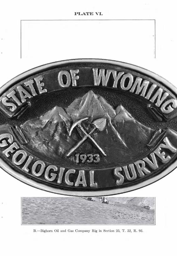
A.-View of the Torchlight Dome, looking east, showing the gentle curvature of thebeds. Buildings of the Bighorn Oil and Gas Company in the foreground
B.-Bighorn Oil and Gas Company Rig in Section 25, T. 52, R. 93.
-39-
THE OIL AND GAS PRODUCING STRUCTURES
T01'chlight Dorne. The most pronounced one of thesmaller domes of the district is the so-called Torchlightdome, located about 2Y2 miles directly east of Basin. Inform it is much elongated, having its center a little east ofthe center of section 24, T. 51 N., R. 93 W., and its longdirection about N. 50 degrees W. The southeastern endof the fold is somewhat sharper than the northwesternend, which is in reality much more blunt than representedon the map. Due to an error in tracing the contours thetrue form of this part of the dome is not shown on the map.The 3500-foot and 3600-foot contours have been extendedtoward the northwest to include most of section 14, whichshould not have been done. Contour 3500 should not extend beyond the position now occupied by contour 3600,at this end of the dome. .
On the southwest side of the Torchlight dome thePeay sandstone descends to sea level, or below, within'the limits of the district. On the northeast it descendsto elevation 3500 with a dip not exceeding 7Y2 degrees,and then becomes horizontal for a distance of a mile alongthe line of section A-A, after which another drop of 200feet occurs. Farther along section A-A there are severalgentle anticlines and synclines, not represented on the mapby contours. The top of the dome is thus seen to be between 600 and 700 feet above the bottom of the broadsyncline valley to the northeast.
THE LAMB ANTICLINE
North of the Torchlight dome is a smaller dome structure, known locally as the Lamb anticline. The top ofthe Peay sandstone on the center of this dome has an elevation of a little over 3700 feet while the surface elevationvaries from 4100 to 4300. As compared with the Torchlight dome the Lamb anticline is smaller and does not riseto as great an elevation. It is separated from the Torchlight dome by a syncline which has a sag of about 250 feetin its deepest portion.
-40-
PEAY ANTICLINE
Southeast of Greybull is a prominent anticlinal elevation known as Peay Hill on which the contoured sandstonemember (Peay sandstone) outcrops and forms a verticalcliff 60 to 75 feet high along the river-front. This structurelies close t.o the southern end of the Sheep Mountain anticline, the depression, or syncline, separating them beingonly about 200 feet deep. The northern end is roundedwhile the southern end is much more pointed and is drawnout into a long curved anticlinal ridge which terminatesjust north of the Lamb anticline. The end of this ridgeseems to be broader than that portion which connectsit with t.he Peay anticline. This condition led to the beliefon the part of drillers in the existence of a pronounceddome which has its center somewhere in section 25. Itis imown locally as the Crescent dome, but in reality it isnot a dome, but merely the broad end of the attenuatedsoutheastern extension of the Peay anticline. It is separated from the north end of the Lamb anticline by a shallowstructural depression a little more than 100 feet in depth.
On the east side of the Peay anticline the dips are g<.>ntIe toward the great syncline. On the west along theGreybull River, the dip is stronger, increasing to a maximum of nearly 40 degrees within two miles from the centerof the dome. To the north the direction of the contoursis controlled for a short distance only by the Peay anticline,coming rapidly under the influence of the larger SheepMountain fold.
By way of comparison of these anticlines it might besaid that the Torchlight dome rises higher on all sidesthan do the other two, having thus an independent domestructure of greater size than the others. The Lamb anticline comes next, and finally the Greybull, or Peay anticline. They are all, however, of comparatively smallSize.
FAULTS
Faulting on a large scale was not observed in this district. It is hardly to be expected that faults would be
-41-
detected in a great part of the district owing to the softshales and obscure bedding, but along the harder sandstoneoutcrops southeast of Greybull several faults can be seen.Southwest of Greybull, along the escarpment of Peay sandstone between the railroad shops and the Greybull Rivera small fault can plainly be seen. Still farther south alongthis escarpment near the southern boundary of Section28, township 52 N., R. 93 W., a small fault has been reported. It is not believed that faulting on a large scaleexists in the proximity of the oil or gas structures, thoughthe minor slips above referred to undoubtedly exist.
Along the northeast margin of the great syncline wherethe dip is observed in some places to be as high as 60 degreesand the change from the almost level floor of the synclineis very abrupt some faulting probably took place. Thebeds are thinned greatly due to stretching during the folding. Evidence of considerable faulting, however, is altogether lacking.
THE OIL AND GAS HORIZONS
There are two productive horizons in the Basin andGreybull field. The lowest is that from which the oil andgas are obtained in the Peay anticline, near Greybull.This is known among drillers as the Greybull sand and isthe same as the Cloverly according to a comparison of verycarefully measured sections on the surface, with drill records. The second horizon is commonly called the Kimballsand and corresponds as nearly as can be determined fromthe meager well records obtainable, with the Mowry sandyshale member. This horizon is approximately 600 feetabove the "Greybull sand", and 450 feet below the top ofthe Peay sandstone ("A" sandstone of Washburne). Theoil of the Torchlight dome, and the oil and gas of the Lambanticline come from the Kimball sand.
THE OCCURRENCE OF THE OIL AND GAS
TORCHLIGHT DOME
The distribution of the productive wells in the Torchlight field shows plainly that the oil exists in the very
-42--
top of the dome structure. Very little gas has been obtained from this area, and from the presence of the oil inthe top of the dome it is not to be expected that gas in anyimportant quantity will be found here. Gas is, however,generally present in the productive domes of the BighornBasin, and it is quite likely that it was present here atsome time in the past, but due to the deep erosion that hasbrought the productive stratum so near the surface the gasmay have escaped.
THE LAMB ANTICLINE
Both gas and oil are obtained from this structure, thewells on the northeast side near the top producing gas,while on the opposite side of the dome and at a somewhatlower level oil was obtained. A small amount of oil wasalso obtained at the northern end of the anticline, but upto the time of completing the field work no oil had beenfound on the northeast side. A dry hole was drilled insection 7, T. 51 N., R. 92 W., near the township line, whichlocation is well up on the dome and if the oil occurred onthis side as it does on the opposite side this well should havegiven gas or oil. The absence of oil or gas on the northeastflank of the anticline, except near the top where gas isobtained, shows that special conditions not provided forby the anticlinal theory must prevail here.
It should also be remarked that in well T. 7 a flow ofgas was obtained only after pumping out considerablewater, while a free flow of gas at a high pressure was obtained at wells T. 5 and T. 6, located in section 12, T. 51N., R. 93 W., and structurally lower on the dome than T. 7.
It should further be stated that fresh water was obtained from the Peay sandstone in well T. 7, while on theTorchlight dome the Peay water was black and stinking.Details relating to these wells were withheld by the drillingcompanies, pending adjustment of various claims, so thatthe explanation of these special conditions is rendered difficult, if not impossible, by the incomplete data at hand.
A possible explanation for the difference in the water
-43-
encountered in the Peay sandstone on the two domes maybe found in the eastern source of the water supply. Theintake of these waters is along the slopes of the BighornMountains at an elevation somewhat, though not greatly,above the level of the sandstone in this part of the district.An outlet for the water occurs along Bighorn River, nearGreybull, where the Peay sandstone is exposed by erosion.The steep slope of the beds on the southwest side of theTorchlight dome prevents any outlet of the waters in thatdirection and causes stagnation in the top of the dome. Thesame condition would occur at the top of the Lamb anticline, while on the flanks, as at well T. 7, there wouldprobably be some circulation, inasmuch as the waterswould flow toward the outcrop of the Peay sandstone onPeay Hill, to the northwest. It may also be that thepressure of the waters from the northeast has caused theoil to migrate to the other side of the dome. These explanations are to be regarded as suggestions rather than demonstrations.
THE PEAY ANTICLINE
The first well drilled within the district was the Minergas well located on this anticline in Sec. 21, T. 52 N., R.93 W., on the east bank of the Bighorn River. Subsequentprospecting has developed a considerable number of bothgas and oil wells on this structure. The gas wells are located near the top of the dome, east of the Bighorn R:iver,while the oil wells are singularly found only on the westside of the dome, along the Greybull and Bighorn Rivers.All attempts to obtain oil on the east slope of the anticlinehave failed. Wells G. 15 and G. 16 in section 22 werewater wells, in spite of their favorable location on thebasis of the anticlinal theory. G. 16 might be counteddoubtful, since it occurs on the same elevation as the bottomof the trough between the Pea~T anticline and the SheepMountain uplift, about a mile north of the well site. ButG. 15 is above that level and should have produced oil orgas under normal anticlinal conditions.
The distribution of the oil wells on the west side of
-44-
the dome may be accounted for in a large measure by therelation of the Peay anticline to the Sheep Mountain fold.North of the east-west line passing through the bottom ofthe trough separating the two anticlines, the slope of thebeds is continuous up the side of Sheep Mountain. Southof that line the slope up along the beds leads to the top ofPeay anticline. A few of the wells are so high up that theyare within the independent dome structure of Peay anticline, that is, above the level of the bottom of the syncline between Peay and Sheep Mountain anticlines, but agreat many are below that level and must, therefore, betreated as though they occurred on a monocline, or onthe slope of Sheep Mountain.
The preservation of the oil in such a position can beaccounted for by assuming that the water in its descentfrom the upper part where it enters the oil sand, (alongShell Creek is the nearest exposure of this horizon) effectively seals off the lower portion by the force of capillary attraction and thus prevents the escape of the oil. Anotherexplanation may also be offered, based on the discontinuityof the productive stratum due to faulting, whereby theoil-bearing sands are brought opposite impervious shales.This condition may well be considered at Greybull, sincefaults of sufficient magnitude occur there to have this effect.Still another explanation has been offered, viz., the discontinuity of the productive horizon, because of erosionprevious to the deposition of the overlying beds. In thiscase an unconformity exists, and, to the writer, it appearsthat the basal sands of the upper series would furnish apassageway for the oils though which they might migrateand escape. The writer is inclined to ascribe considerableweight to faulting, as a cause for sealing up the oil on thewest side of the dome.
PROBABLE FUTURE DEVELOPMENTS
The small size of the oil and gas producing structuresof this field precludes the possibility of large scale production.The Torchlight dome yields oil only, and the wells are
-45--
confined to a relatively small area at the top of the anticline so that the quantity of oil that may be expected isnot great. The Lamb anticline will produce gas enoughto supply the small local consumption for a number of years,but, on account of the small size of the dome, the gas supply is surely limited. The quantity of oil on the productiveside of this dome is hard to estimate in the absence of anydata regarding the pressure at the wells and its behaviorafter continuous pumping or flowage for some time. Suchtests have never been made to the knowledge of the writer.The gas and oil of the Peay anticline are likewise difficultto measure, because of lack of testing data, but, in the caseof the gas, it is safe to say that the supply is rapidly beingexhausted. The first well which was allowed to flowuncapped for months apparently exhausted the supply toa great extent, as the present gas pressure is so low that thewells will not "feed" when the higher pressure gas from theLamb anticline is turned into the mains.
The quantity of oil in the Greybull field seems to besomewhat greater than in the other two cases, with thepossible exception of the Torchlight dome. The wellsseem to show oil at a great depth in this structure, and thiswill of course increase the available quantity. No testshave been made to ascertain the capacity of any of thewells, according to a statement of Mr. H. T. Lamb, andwithout this data it is impossible to make a definite estimate of available supply.
CHARACTER OF THE OIL AND GAS
The oils obtained in the Basin and Greybull field are ofa paraffin base, and generally of light gravity. Mr. Lambreports that the oil from Well No. T. 4 gave a test of 28°Baume, and of Well No. T. 14 the gravity was 34°, whilethat from Well No. T. 2 tested 46°. The oils are all of agreenish color and have a strong odor of gasoline.
No analysis has been made of the gas from this field,but it may be remarked that it has a strong odor of gasoline and burns with a long, luminous, smoky flame.
-46-
The oil and gas of this field resemble those of the otherfields of the Bighorn Basin.
ORIGIN OF THE OIL AND GAS
The oil and gas of this region are believed to be oforganic origin, coming from the slow distillation of the carbonaceous shales of the Benton. Whether they are ofanimal or of vegetable origin can hardly be determinedwithout complete analyses of the oil and gas, as well asof the rocks, but there seems to be an abundance of darkcarbonaceous matter in the shales of the lower part of theColorado from which these products might be derived.It might be stated that beds of fossilized animal remainsare apparently totally lacking in this region, the onlyindication of former animal life being the fish scales of theMowry shales. These are relatively abundant, however,and the Mowry has a great lateral distribution as well asthickness ranging from 50 feet to several hundred feet, sothat there seems to be evidence of a rather plentiful supplyof fishes in the early Benton sea, and these may have contributed to a large degree toward the oil and gas supply.
The lowest horizon (stratigraphic) from which oil andgas have been obtained in this region is the top of the Cloverly. Practically all of the dark shales of the region lieabove this formation, the layers below being those of thevariegated Morrison beds. It would be difficult to conceive how the oils could have originated below this horizonand migrated to the Cloverly, and higher productive strata,without producing some visible effect upon the highlycolored shales and sands that are characteristic of theMorrison. From this kind of reasoning it seems clear thatthe oil has not come up from below but that it must haveoriginated within the dark shales of the Colorado, andparticularly of the Benton.
The accumulation of the oil and gas seem to be closelyconnected with the structure of the rocks, since commercialquantities of either, or both, are only found in associationwith domes or anticlines, in this field. The raw materials
-47-
which furnished the elements of the oil and gas are widelydisseminated, but concentration of the distillates has beenrestricted to certain localities having favorable structuresin which they became stored. Concentration of the oiland gas involves transportation of the small portions thatwere formed, in place, from the disseminated organic remains to these structures. Such movement may be downward, under the influence of gravity, or it may be upwardfrom hydrostatic pressure, due to circulating waters. Theretention of the oil or gas when under pressure is only possible when some impervious cover is available. In thisfield there is an abundance of shale which has effectuallyclosed off all avenues of escape and held the oil and gasconfined in the lower more porous strata.
LOCATIONS ANb DEVELOPMENT
Numerous locations of oil and gas claims have beenmade by different parties, among which the following aremore or less prominent: A. S. Mercer, et al.; Elmer Todd,et al.; W. S. Lenix, et al.; H. H. Hime, et al.; Homer T.Lamb, et a1.; Greybull Oil Company; Bighorn Oil & GasCompany; Fullerton Oil Company.
Of these only the last four have succeeded in gettingproductive ground, and nearly all of the development workin these fields has been done by them. Mr. Homer T. Lambrepresents the Greybull Oil Co., Bighorn Oil & Gas Co.,Bighorn Drilling Co., and Bighorn Supply Co., which bringsthe interests of these companies under one management.All of the drilling operations of these companies as well asa number of others for smaller companies, have been supervised by Mr. Lamb. The Fullerton Oil Company hasalso done considerable drilling in this region, particularlyon the Torchlight dome.
THE OIL AND GAS WELLS
More than 60 wells have been drilled in the Basin andGreybull oil and gas field to date. The present report
-48-
deals with 58 of these, showing the location and results ofdrilling, together with the elevation at the mouth of eachwell. Log data has been withheld, on most of the wells,pending litigation which is now in progress, but partiallogs have been obtained for some of the' wells. In thefollowing pages all the data at hand is presented for eachindividual well, and the order of treatment is by fields, andoperating companies, except in a few cases.
WELLS IN THE KIMBALL SAND
The following is a list of the wells located on the Torchlight and Lamb anticlines, and belonging principally tothe Lamb interests, and to the Fullerton Oil Company.
Well No. T. 1. Owned by the Greybull Oil Company.Located in the northeast corner of the northeast quarterof the southwest quarter of section ~4, T. 51 N., R. 93 W.Elevation at the mouth of the well, 41~8. Data regardingthis well has been withheld, but it is known to be an oilwell of shallow depth. Sulphur water and a small showingof oil and gas was encountered in the Peay sandstone, whichis here about ~oo feet below the surface. The oil obtainedfrom the Kimball sand is said to be of light gravity. Drilledin the spring of 1914.
Well No. T. fJ.. Owned b~' the Greybull Oil Co.; located in the southeast corner, southeast quarter, northwest quarter, section ~4, T. 51 N., R. 93 W. Elevationat the mouth of the well, 41~8. Data withheld, but itis reported to be an oil well similar to T. 1. Drilled in thespring of 1914.
Well No. T. 3. Owned by Greybull Oil Company.Located in the northeast corner of the northeast quarterof the northwest quarter of section ~4, T. 51 N., R. 93 W.Elevation at the mouth of the well is 4~~5. The hole wasstarted at the base of the Torchlight sandstone, but dataregarding the formations passed through have been withheld,but it is known that oil was obtained in the Kimball sand.
Well No. T. 4. Greybull Oil Company, owner. Thewell situated in the southwest corner of the southwest
-49--
quarter of section 12, T. 51 N., R. 93 W. The elevationat the mouth of the well is 4260. The well was startedin the middle portion of the Basin shales and oil was obtained presumably in the Kimball sand. Log data withheld. Up to the end of the field season this was the onlygood oil well located on the Lamb anticline.
Well No. T. 5. Greybull Oil Company, owner. Thewell situated in the south half of the southeast quarter ofthe southeast quarter of section 12, T. 51 N., R. 93 W.Elevation at the mouth of the well, 4178. The well wasstarted at the top of the Torchlight sandstone and gaswas obtained from the Kimball sand. Details regardingthe formations passed through were withheld.
Well No. T. 6. Greybull Oil Company, owner. Welllocated in the southwest corner of the northeast quarterof the southwest quarter of Section 7, T. 51 N., R. 92 W.Elevation at the mouth of the well, 4228. This well wasstarted at a point about fifty feet above the top of theTorchlight sandstone, and was continued to the Kimballsand in which gas was obtained. Log data withheld.
Well No. T. 7. Greybull Oil Company, owner. Welllocated in the southwest corner of the southeast quarter ofthe northeast quarter of Section 12, T. 51 N., R. 93 W.Elevation at the top of the casing, 4278. This well wasstarted at a point about 100 feet above the base of theBasin shale. Water was encountered in the Greybullsand and gas and water in the Kimball sand. After pumping the water for some time the gas began to :flow. Logdata withheld.
Well No. T. 8. Greybull Oil Company, owner. Welllocated in the southeast corner of the southwest quarterof the northwest quarter of Section 7, T. 51 N., R. 92 W.The elevation at the mouth of the well, 4595. This wellwas started in the Basin shale about 400 feet above the topof the Torchlight sandstone, and was drilled presumablyto the Kimball sand, where water was obtained. Logdata withheld.
Well No. T. 9. Greybull Oil Company, owner. The
4-
-50-
well is situated in the northwest corner of the northwestquarter of the southeast quarter of Section 18, T. 51 N.,R. 92 W. The hole was started at a point about 300feet above the top of the Torchlight sandstone and wasdrilled to the Kimball sand. The hole was reported dry.Log data not given.
Well No. T. 10. Well drilled by Holdridge & Champion, of Denver, Colo. Located in the southwest cornerof the southwest quarter of section 18, T. 51 N., R. 92 W.Elevation at the mouth of the well, 4110. The well wasstarted at a point about 150 feet above the top of theTorchlight sandstone. Data regarding the formationspassed through was not obtainable. The well was drilledduring July and August, 1914. Oil was later reported.
Well No. T. 11. Well drilled by the Greybull OilCompany, on Government land. Located in the northwestcorner of the northeast quarter of the northeast quarterof section 19, T. 51 N., R. 92 W. Elevation at the mouthof the well, 4395. The well was started at a point about650 feet above the top of the Torchlight sandstone. Logdata was withheld. The hole was reported to be dry.
Well No. T. 112. Owner unknown. Well situated inthe northwest corner of the southwest quarter of the southeast quarter of Section 35, T. 51 N., R. 92 W. The elevation at the mouth of the well, about 4240. The well wasdrilled near the top of a small anticline, with negativeresults.
Well No. T. 13. Owner unknown. Drilling has neverbeen done, but a standard derrick marks the location ofthis well site, which is in the northeast corner of the northwest quarter of the northeast quarter of Section 35, T.51 N., R. 92 W. The elevation at the surface at this pointis 4263. The formation here exposed is approximatelythe top of the Basin shale.
Well No. T. 14. Greybull Oil Company, owner.Well located in the southwest corner of the northwestquarter of the northwest quarter of Section 1, T. 51 N.,R. 93 W. The elevation at the top of the casing is 4419.
-51-
The well was started at a point about 650 feet above thetop of the Torchlight sandstone, and was drilled to theKimball sand, in which a heavy lubricating oil and saltwater were found. The well was drilled during July,1914. Log data withheld.
Well No. T. 15. Greybull Oil Company, owner.Well was located in the northwest corner of the southwestquarter of the southeast quarter of section 25, T. 52 N.,R. 93 W. The elevation at the mouth of the casing is.approximately 4500. This well was still being drilledwhen the party left the field, and the results of the drillinghave not been ascertained. The well was started in theBasin shale at a. point about 700 feet above the top of theTorchlight sandstone. Finally reported dry.
Well No. T. 16. Elmer Todd, et al., owners. Thewell is located in the northeast corner of the northwestquarter of the southwest quarter of Section 25, T. 51 N.,R. 93 W. The elevation at the mouth of the well is 9385.The well was drilled during the spring of 1914. The holewas started at a point near the top of the Basin shale andwas continued to the Kimball sand with negative results.Log data not obtainable.
Well No. T. 17. Elmer Todd, et al., owners. Thewell was located at the northwest corner of the southeastquarter of the southwest quarter of section 25, T. 51 N.,R. 93 W. The elevation at the mouth of the well was 4055.The hole was reported to be dry. It was drilled during thespring of 1914.
Well No. C. 1. The Fullerton Oil Company, owner.Well was located in the northeast corner of the southeastquarter of the northeast quarter of Section 10, T. 51 N.,R. 93 W. The elevation at the mouth of the well is 3880.The well was started at a point about 225 feet above thetop of the Torchlight sandstone. The well was drilledto the Greybull sand, where water was encountered. Thewell was drilled during June and July, 1914. Log datawithheld.
Well No. C. 12. Fullerton Oil Company, owner. Wellis located in the northwest corner of the southeast quarter
-52-
of Section 24, T. 51 N., R. 93 W. The elevation at themouth of the well, 4107. The well was started in theUpper Benton shale at a point about 200 feet above the Peaysandstone. Details regarding the formations passed throughhave not been furnished for publication, but it is knownthat oil was obtained at a comparatively shallow depthin the Kimball sand.
Well No. C. 3. The Fullerton Oil Company, owner.-Well is located in the northwest quarter of the southeastquarter of Section 24, T. 51 N., R. 93 W. Elevation atthe mouth of the well, 4072. The well was started in theUpper Benton shale, at a point about 200 feet above thetop of the Peay sandstone. Data regarding the formationspassed through in drilling were not furnished for publication, but it is known that oil was obtained at a comparatively shallow depth, presumably at the same horizon asthe well· No. C. 2.
Well No. C. 4. The Fullerton Oil Company, owner.Well was located very close beside well No. C. 3. and thesame conditions were found in this well as in C. 2 and C. 3.The elevation at the mouth of the well, 4072. Log datahave been withheld, but it is known that oil was obtainedat a shallow depth of a few hundred feet, presumably fromKimball sand.
Well No. C. 5. The Fullerton Oil Company, owner.Well was located in the southeast corner of the northeastquarter of Section 24, T. 51 N., R. 93 W. The elevationat the mouth of this well is 4126. This well was startedin the Upper Benton shale at a point about 200 feet abovethe Peay sandstone. Log data was withheld, but it isknown that oil was obtained at a shallow depth, presumablyfrom KimbaIi sand.
Well No. C. 6. Hiatus well, owned by the FullertonOil Company. Located in the northwest corner of thenorthwest quarter of Section 30, T. 51 N., R. 92 W. Elevation at the mouth of the well, 4185. The well wasstarted at a point near the top of the Torchlight sandstone,and was drilled through the Kimball sand where oil was
-53-
obtained. Details regarding the formations passed throughhave been withheld.
Well No. C. 7. Greybull Oil Company, owners. Wellis located in the southeast corner of the southwest quarterof the southwest quarter of Section 19, T. 51 N., R. 92 W.Elevation at the mouth of the well is 4208. Log data withheld. This well was drilled in the spring of 1914, and oilwas obtained at a comparatively shallow depth. Wellstarted at a point near the top of the Torchlight sandstone,and the well was drilled through to the Kimball sand, whereoil was obtained.
Well No. C. 8. Due to an error in transferring datagathered in the field to the map, a small pump house wasrepresented as an oil well. There is no well correspondingto C. 8.
Well No. C. 9. Greybull Oil Company, owners. Wellwas located in the west half of the northwest quarter ofthe southwest quarter of Section 19, T. 51 N., R. 92 W.Elevation at the mouth of the well, 4145. The well wasstarted at a point near the base of the Torchlight sandstoneand was continued down to the Kimball sand, where oilwas obtained. Log data have been withheld.
Well No. C. 10. Greybull Oil Company, owners.Located in the northwest corner of the northwest quarterof the southwest quarter of Section 19, T. 51 N., R. 92 W.Conditions in this well were the same as in C. 9.
Well No. A. 1. The Sherard well. Located in thenorthwest corner of the northwest quarter of Section 11,T. 51 N., R. 93 W. Elevation at the mouth of the well,3905. This well was drilled several years ago and detailsregarding the formations passed through have not beenobtainable.
WELLS IN THE CLOVERLY, OR GREYBULL SAND
Well No. G. 1. The Node well. Located at the southwest corner of the northeast quarter of the northeast quar-
-54-
tel' of Section 8, T. 52 N., R. 93 W. A partial log of thiswell is as follows:
Peay sandstone (A) 21 ft.Top of Cloverly (Greybull sand) 1092 ft. WaterBottom of well (Red beds).. . . . 1106 ft.
Well No. G. 2. Located in the southwest corner ofthe northeast quarter of the southeast quarter of Section9, T. 52 N., R. 93 W. Elevation at the top of the wellis 3828. This well is said to be dry by Mr. H. T. Lamb,but laymen about Greybull say that oil was obtained fromthis well. Well was started near the top of the Peay sandstone and was drilled to the Greybull sand. Log datawithheld.
Well No. G. 3. Greybull Oil Company, owners. Located in the southeast corner of the northeast quarterof section 18, T. 52 N., R. 93 W. The elevation at thetop of this well is 3830. Partial well record is as follows:
Top of Peay sandstone (A) reached at depth of .. 680 ft. Water."Muddy" sand reached at. 1410 ft.Top of Cloverly . . . . . . .. 1730 ft.Bottom of well. . . . 1965 ft.
The bottom of this well was approximately 200 feetbelow the top of the Cloverly, (Greybull sand) in the redbeds. No water or gas was obtained in any sand belowthe Peay sandstone.
Well No. G. 4. Bighorn Oil and Gas Company, owners.Located in the southeast corner of the southwest quarterof the northeast quarter of Section 17, T. 52 N., R. 93 W.The elevation at the top of casing is 3823. Log data withheld. Oil was obtained in the Greybull sand.
Well No. G. 5. Bighorn Oil & Gas Company, owners.Well is located in the northeast corner of the southeastquarter of the northeast quarter of Section 17, T. 52 N.,R. 93 W. The elevation at the top of this well, 3779.Log data was withheld, but it is known that oil was obtained in this well at a depth of approximately 1000 feet,in the Greybull sand.
Well No. G. 6. Bighorn Oil & Gas Company, owners.Well is located on an island in the Bighorn River, in the
-55-
southwest corner of the northwest quarter of Section 16,T. 52 N., R. 93 W. The elevation at the mouth of the wellis 3780. Log data have been withheld, but it is reportedthat gas was obtained in the Greybull sand. The occurrence of gas in this well was not expected.
Well No. G. 7. Bighorn Oil & Gas Company, owners.Well is located in the northwest corner of the southwestquarter of Section 16, T. 52 N., R. 93 W., on an island inthe Bighorn River. The elevation at the top of the casingis 3780. Log data withheld.
Well No. G. 8. Bighorn Oil & Gas Company, owners.The well is located in the northeast corner of the southwestquarter of the northwest quarter of Section 16, T. 52 N.,R. 93 W. The elevation at the top of the casing is approximately 3950. Log data withheld. Gas was obtainedfrom the Greybull sand.
Well No. G. 9. Bighorn Oil & Gas Company, owners.This well is located in the northeast corner of the northwestquarter of the southwest quarter of Section 16, T. 52 N.,R. 93 W. The log of this well was withheld, but it is reported that gas was obtained in the Greybull sand at adepth of about 1065 feet.
Well No. G. 10. Bighorn Oil & Gas Company, owners.This well was located in the northeast corner of the southwest quarter of Section 16, T. 52 N., R. 93 W. The wellrecord was withheld but gas is reported to have been obtained from the Greybull sand.
Well No. G. 11. Bighorn Oil & Gas Company, owners.The well is located in the northeast quarter of the southwest quarter of Section 16, T. 52 N., R. 93 W. Well recordwas not obtainable, but this well is said to produce gasfrom the Greybull sand.
H1ell No. G. 12. Bighorn Oil & Gas Company, owners.Located in the southwest corner of the southeast quarterof Section 16, T. 52 N., R. 93 W. Log data not obtainable,but the owners report gas from the Greybull sand.
Well No. G. 13. Bighorn Oil & Gas Company, owners.
-56-
'Well is located in the northwest corner of the northeastquarter of Section 21, T. 52 N., R. 93 W. Log data notobtainable, but the owners report gas from the Greybullsand.
G. 14. There is no well corresponding to G. 14, asshown on the map.
Well No. 0. 15. Owners unknown. Located in thesouthwest quarter of the northwest quarter of Section 22,T. 52 N., R. 93 W. This hole was drilled by Mr. H. T.Lamb, who has kindly furnished the following partial log :
Top of the "Muddy" sand. . . . . . . . . 790 ft.Top of the Cloverly. . . . . . . . . . . . . . . . .. 1116 ft.Base of the Cloverly ... . . . . . . . . . . . . . . . . . . .. 1134 ft.Bottom of the hole. . . . . . . . . . . . . . . . . . . . . 1175 ft.All sands reported dry.
Well No. G. 16. Owner unknown. Located in thenortheast corner of the southwest quarter of Section 22,T. 52 N., R. 93 W. This well was drilled by Mr. H. T.Lamb, who has furnished the following data:
Top of the "Muddy" sand . . . . . . .. . . . . 870 ft."Greybull" sand. . . . . . . . . . . . . 1197-1215 ft.Bottom of the well. . . . . . . . . . 1220 ft.All sands dry. The top of this well has an elevation, 3963. The drilling
began at the top of the Peay sandstone.
Well No. G. 17. Bighorn Oil & Gas Company, owners.Well located in the northwest corner of the southeastquarter of Section 21, T. 52 N., R. 93 W. Partial loghas been furnished by Mr. H. T. Lamb, as follows:
Top of the "Greybull" sand. 1075 ft. Water.Bottom of the well. . . . . . . . . .. 1150 ft. Water.
This well is located at the top of the Peay anticline,and the presence of water in the Greybull sand is thereforerather surprising. Special conditions not accounted forby the anticlinal theory must exist at this point.
Well No. G. 18. Skinner well. Owner unknown.Located in the northeast quarter of the northwest quarterof Section 28,' T. 52 N., R. 93 W. The elevation at themouth of the well is 3798. This well was drilled during1913 by Mr. H. T. Lamb, who has furnished the followingpartial log:
At the present time water and gas are overflowing thetop of this well in small quantities. The gas comes presumably from the Greybull sand.
Well No. G. 19. The Maloney well. Owner unknown.Located in the southwest quarter of the southwest quarterof Section 21, T. 52 N., R. 93 W. This well was drilledduring 1913 by Mr. H. T. Lamb, who has furnished thefollowing partial log:
Top of the "Muddy" sand . . . . . . . . . . . . . . . . . . 613 ft.Some gas in the "Muddy" sand.
Top of the "Greybull" sand . . . . . . . . . . . . . . . . . . . . . . . . 936 ft.Water in the "Greybull" sand.
Bottom of the "Greybull" sand . 960 ft.
Well No. G. fdO. Owner unknown. Located in thenorthwest corner of the southwest quarter of Section 28,T. 52 N., R. 93 W. Elevation at the mouth of the well,3855. This well was being drilled during July and August,1914. Results unknown.
Well No. G. fd1. Bighorn Oil & Gas Company, owners.Well located in the southwest corner of the northwestquarter of Section 21, T. 52 N., R. 93 W. The elevationat the top of the casing is 3790. Log data not obtainable.This well is reported to have obtained oil from the Gre~7bull
sand.
Well No. G. fdfd. Bighorn Oil & Gas Company, owners.Located at the southeast corner of the northeast quarterof Section 19, T. 52 N., R. 93 W. Elevation at the mouthof the well, 3795. The log data not obtainable, but it isknown that oil is obtained from the Greybull sand. Thiswell is located on the north bank of the Greybull River,and was started at a point approximately in the center ofthe Basin shale.
Well No. G. fd3. Bighorn Oil & Gas Company, owners.Well located on the north bank of the Greybull River.In the northeast quarter of the northeast quarter of Sec-
-58-
tion 20, T. 52 N., R. 93 W. Elevation at the mouth ofthis well is 3791. Log data were withheld, but it is reportedthat oil was obtained from the "Greybull" sand.
Well No. G. 24. Bighorn Oil & Gas Company, owners.Located at the northeast corner of the northeast quarterof Section 20, T. 52 N., R. 93 W. Elevation at the topof the casing 3786. Log data not furnished, but oil is reported to have been obtained in the "Greybull" sand.
Well No. G. 25. Bighorn Oil & Gas Company, owners.Located at the southeast corner of the southeast quarterof Section 17, T. 52 N., R. 93 W. Elevation at the topof the casing, 3784. The log of this well was withheld,but it is reported that oil was obtained from the Cloverlyor "Greybull" sand.
Well No. G. 26. Bighorn Oil & Gas Company, owners.Located at the southeast corner of the northwest quarterof the southeast quarter of Section 17, T. 52 N., R. 93 W.The elevation at the top of the casing, 3825. The logof this well was withheld, but oil is reported from the"Greybull" sand.
Well No. G. 27. Bighorn Oil & Gas Company, owners.Located at the northeast corner of the southeast quarterof the southwest quarter of Section 17, T. 52 N., R. 93 W.The elevation at the top of the casing is 3828. This wellwas started at a point approximately at the top of theTorchlight sandstone. The log of the well was not obtainable, but it is reported that oil was obtained from the"Greybull" sand.
Well No. G. 28. Jewel oil well. Bighorn Oil & GasCompany, owners. Located at the southeast corner ofthe southeast quarter of Section 18, T. 52 N., R. 93 W.The elevation at the top of the casing is 3830. This wellshows the following partial log data, as furnished by Mr.H. T. Lamb:
Shale, with abundant water .. . .Top of the Peay sandstone (A) .Top of the "Muddy" sand .Top of the "Greybull" sand .Bottom of the well .
125 ft.770 ft.
1475 ft.1795 ft.1830 ft.
-59-
800 ft.1144-1160 ft Water.
1200 ft.1302 ft. Water.
By pumping, this well yields a small amount of oilfrom the "Greybull" sand.
Well No. G. 929. Bighorn Oil & Gas Company, owners.Located in the center of the southeast quarter of the northwest quarter of Section 21, T. 52 N., R. 93 W. Log datawithheld. Gas has been reported as obtained from the"Greybull" sand.
Well No. G. 929. Owner unknown. Located in thesoutheast corner of the northwest quarter. of Section 15,T. 52 N., R. 93 W. Mr. H. T. Lamb has furnished thefollowing partial log of this well:
Top of the "Muddy" sand"Greybull" (?) .Stray sandRed beds.The elevation at the mouth of this well is 3930.
p
Well No. G. 30. Bighorn Oil & Gas Company, owners.Located in the northeast corner of the southwest quarterof the northwest quarter of Section 21, T. 52 N., R. 93 W.The log of this well was withheld. Gas is reported from the"Greybull" sand.
Well No. G. 81. Armstrong well. (Not shown onthe map.) Located on Lot No.4 in Section 16, T. 52 N.,R. 93 W. This well is owned by the Bighorn Oil & GasCompany. The following data has been furnished byManager H. T. Lamb:
Top of the "Greybull" sand. .. . . . . . . . . .. 1075 ft.Bottom of the "Greybull" sand . 1095 ft.
Gas obtained from the "Greybull" sand. The pressureat this well is said to be between 120 and 400 lb., furnishing2000 cu. ft. of gas per day.
BIBLIOGRAPHY
DARTON, N. H. Preliminary Report on the Geology and Underground WaterResources of the Central Great Plains. U. S. Geol. Survey Prof.Paper 32, 1905.Geology of the Bighorn Mountains,Wyoming. U. S. Geol.Survey Prof. Paper 51, 1906.Paleozoic and Mesozoic of Central Wyoming Gool. Soc. America Bull. Vol. 19, 1908.
DARTON, N. H. AND BLACKWELDER, ELIOT. Laramie-Sherman Quadrangle,U. S. Geol. Survey Folio No. 173, 1910.
DARTON, N. H., & SIEBENTHAL, C. E. Geology and Mineral Resources ofthe Laramie Basin, Wyo. U. S. Geol. Survey Bull. 364, 1909.
ELDRIDGE, G. H. A Geological Reconnaissance of Northwest Wyoming.U. S. Geol. Survey Bull. 119, 1894.
FISHER, C. A. Coal of the Bighorn Basin, in Northwest Wyoming. U. S.Geol. Survey Bull. 225, 1904.The Bentonite Deposits of Wyoming. U. S. Geol. Survey Bull.260,1904.Geology and Water Resources of the Bighorn Basin, Wyoming.U. S. Geol. Survey Prof. Paper 53, 1906.Mineral Resources of the Bighorn Basin. U. S. Geol. SurveyBull. 285, 1906.Southern Extension of the Kootenai and Montana Coal-bearingFormations in Northern Montana. Econ. Geology, Vol. 3,1908.
GILBERT, G. I~. The Underground Water of the Arkansas Valley in EasternColorado. U. S. Geol. Survey 17 Ann. Report, Pt. II, 1895-96.
HEWETT, D. F. The Shoshone River Section, Wyoming. U. S. GeoL Survey Bull. 541-C, 1914.
JAMISON,
KNIGHT,
STANTON,
C. E. Mineral Resources of Wyoming. Bull. No.1, Series B.,1911.The Salt Creek Oil Field, Natrona County, Wyoming. Bull.No.4, Series B., 1912.
W. C. Preliminary Report on the Artesian Basins of Wyoming.Wyoming Experiment Station Bull. No. 45, 1900.Reconnaissance Geologic Map of Wyoming. University ofWyoming.
T. W. The Colorado Formation and its Invertebrate Fauna.U. S. Geological Survey Bull. 106, 1893.
-62-
STANTON, T. W., AND HATCHER, J. B. Geology and Paleontology of theJudith River Beds. U. S. Geol. Survey Bull. 257, 1905.
TRUMBULL, L. W. The Salt Crpek Oil Field, Natrona County, Wyoming.Bull. 8, Series B, 1914.
WASHBURNE, C. W. Gas Fields of the Bighorn Basin, Wyoming. U. S.Geo!. Survey Bull. 340, 1908.Coal Fields of the Northeast Side of the Bighorn Basin, Wyoming. U. S. Geo!. Survey Bull. 341, 1909. ~
WEGEMANN, C. H. The Salt Creek Oil Field, Natrona Co., Wyoming.U. S. Geological Survey Bull. 452, 1911.
WOODRUFF, E. G. Coal in the Southeastern Part of the Bighorn Basin, Wyo.U. S. Geo!. Survey Bull. 381, 1908.Coal Fields of the Southwest Side of the Bighorn Basin, Wyo.U. S. Geol. Survey Bull. 341, 1909.