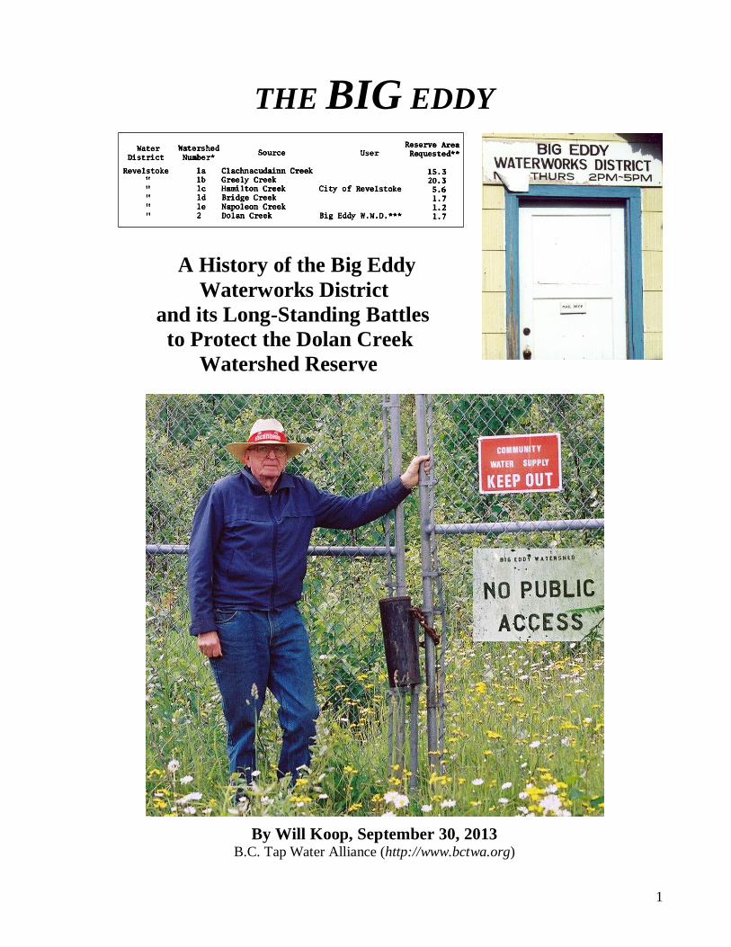
1 THE BIG EDDY A History of the Big Eddy Waterworks District and its Long-Standing Battles to Protect the Dolan Creek Watershed Reserve By Will Koop, September 30, 2013 B.C. Tap Water Alliance (http://www.bctwa.org)
Transcript
1
THE BIG EDDY
A History of the Big Eddy Waterworks District and its Long-Standing Battles to Protect the Dolan Creek Watershed Reserve
By Will Koop, September 30, 2013 B.C. Tap Water Alliance (http://www.bctwa.org)
99
4. THE MYSTERY OF THE MISSING RESERVES
When land, which includes water, is put to use by man, the history of the land, its status, and other pertinent data must be recorded for purposes of government. This record is kept orderly through the use of maps and legal descriptions, properly filed and indexed. This demands knowledge of the surface of the land, obtained in British Columbia through the Surveys and Mapping Service. 97
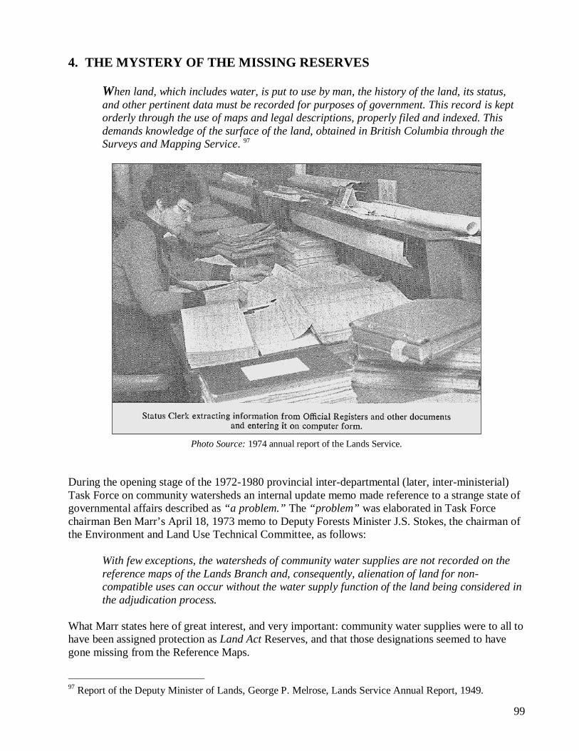
Photo Source: 1974 annual report of the Lands Service. During the opening stage of the 1972-1980 provincial inter-departmental (later, inter-ministerial) Task Force on community watersheds an internal update memo made reference to a strange state of governmental affairs described as “a problem.” The “problem” was elaborated in Task Force chairman Ben Marr’s April 18, 1973 memo to Deputy Forests Minister J.S. Stokes, the chairman of the Environment and Land Use Technical Committee, as follows:
With few exceptions, the watersheds of community water supplies are not recorded on the reference maps of the Lands Branch and, consequently, alienation of land for non-compatible uses can occur without the water supply function of the land being considered in the adjudication process.
What Marr states here of great interest, and very important: community water supplies were to all to have been assigned protection as Land Act Reserves, and that those designations seemed to have gone missing from the Reference Maps.
97 Report of the Deputy Minister of Lands, George P. Melrose, Lands Service Annual Report, 1949.
100
Sample of BC Departmental Reference Maps index once regularly published in the Lands Department’s annual reports. To the right, is an enlargement of Index 4, located above at the top right of the maps index. Note that the Departmental Reference Maps include “Reserves” tenures, amongst many other Crown land applications, permits, etc. From mid-1972 to early 1973, inter-departmental administrators and staff were under orders from the Task Force committee to compile a thorough, preparatory assessment of B.C.’s community watersheds from diverse informational records held by various government agencies and departments, i.e., Water Rights Branch, Water Investigations Branch, Municipal Affairs, the Departments of Health, Lands, and Forests. That assessment included a review of the Lands
101
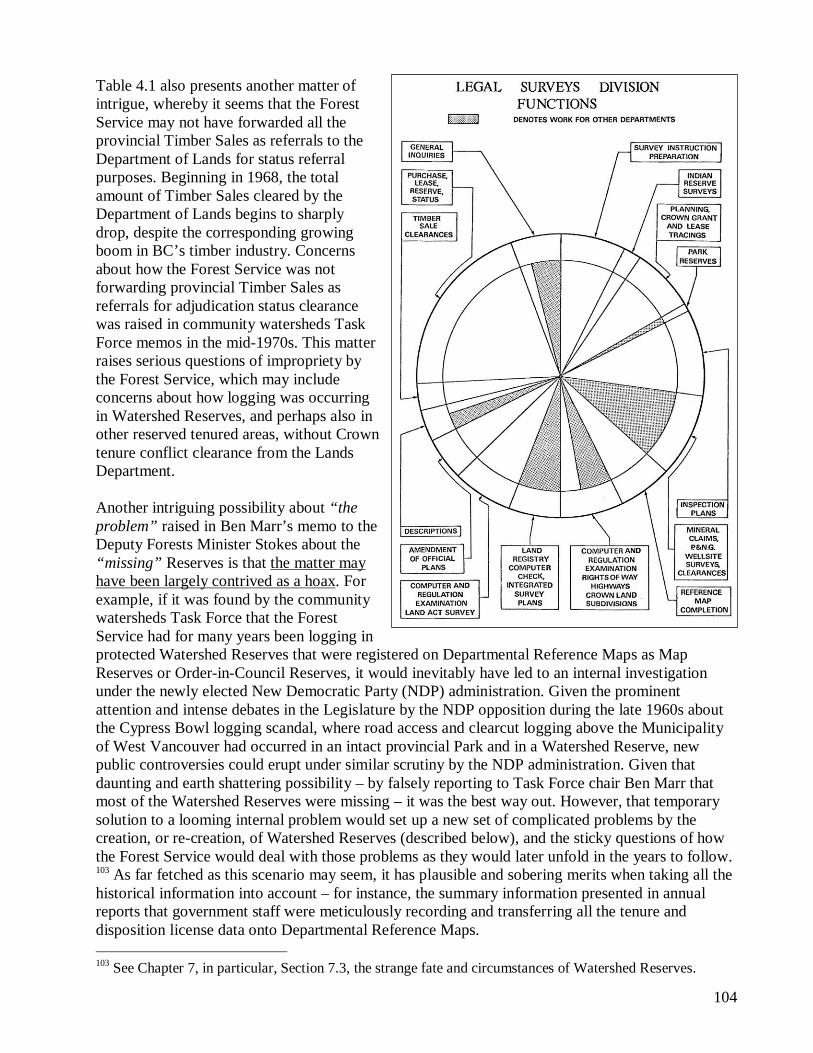
Department central reference maps, the Departmental Reference Maps, where every land use disposition and tenure on provincial lands was officially recorded by the Legal Surveys Division.
The Legal Surveys Division, under the direction of the Surveyor-General, is responsible for cadastral surveys of all Crown lands of the Province.
In order that a graphic record may be kept of alienations of both surveyed and unsurveyed Crown lands together with reserves, a set of 249 reference maps, covering the whole of the Province, must be maintained. These show all cadastral surveys which are on file in the Department, and are kept up to date by adding new information as it accrues from day to day. All applications to purchase or lease Crown lands or foreshore which are received by the Lands Branch and all applications to purchase Crown timber received by the Forest Service are channelled through this Division for clearance. The orderly processing of these applications requires that an exhaustive status be made from the reference maps, official plans, and Land Registry Office plans. From the reference maps, together with other information and facilities maintained by this Division, it is possible to give an up-to-the-minute status of any parcel of Crown land in the Province. It was necessary during the year, for status and compilation purposes, to obtain 2,752 plans from the various Land Registry Offices. This Division co-operates with the other departments of Government by preparing and checking legal descriptions which they require. Those assisted in this way were the Attorney-General’s Department (descriptions of Small Debts Courts), the Department of Agriculture (descriptions of disease-free areas and pound districts), the Forest Service (descriptions of tree-farm licences and working circles), and the Lands Branch (descriptions for gazetted reserves, etc.). 98
Staff apparently discovered and communicated to Task Force chairman Ben Marr that almost all of BC’s community watersheds that were assigned as Watershed Reserves, and those that were thought to be, were not described or registered on the Lands Departmental Reference Maps – most were reportedly missing. Many questions related to this “problem” are:
Why were the registered water purveyors’ “watersheds” 99 missing? Which watersheds were not missing?
98 Department of Lands Annual Report, 1966, page CC-56. The wording of these paragraphs from the reporting section of the Legal Surveys Division went almost unchanged in annual reports from 1955 to 1969, being a standard reporting template. “The structure and role of the former Lands Branch was changed substantially in 1975 with new policy directions developed by the Department” (Annual Report, 1975). 99 Prior to the use of the term first used in the BC Water Resources Department annual report of 1973, “community watersheds” were always referred to as “watersheds” or “water sheds,” a distinction critical for researchers or historians evaluating their early references in government records. That’s what Ben Marr refers to them in his April 18, 1973 memo, the “watersheds” of community water supplies. A “watershed” was also commonly used as a generic term to define the hydro-graphic boundaries of any drainage basin from the height of land to a lower defined point such as a water intake or a tributary, etc. The earliest BC Water Rights annual reports made many references to this generic terminology.
102
Were only Lands Departmental Reference Maps examined at Victoria headquarters, and not the maps held with the other Lands Regional offices?
Were the other sets of Reference Maps held by the Forest Service, the Forest Atlas Maps, examined at Victoria headquarters which would or should have registered the watersheds?
Were the Forest Service Reference Maps held at regional offices examined? Were the Water Rights Reference Maps examined?
No clues to these questions and to the intrigue about the mystery were elaborated in the memo, nor in other Task Force memos reviewed by this report’s author in the archived Task Force files. The matter of the mystery of the missing community Watershed Reserves raises a number of possible concerns. The Reserves may not have been formally registered on the Lands Departmental Reference Maps. Such strange circumstances have periodically occurred in government when controversial issues are in the forefront, 100 particularly as they were evolving in the 1960s about the Watershed Reserves as narrated in Chapter 2. Perhaps the older maps were sent off to storage, and new maps omitted the older information about the Reserves. Perhaps the Reserves were erased from the existing maps. The Department of Lands’ annual report of 1970 states that its Legal Surveys Division had to create 36 new Departmental Reference Maps in 1970 to replace older, worn out maps:
Apart from the processing of applications for disposition, general draughting on existing maps of all interests in land initiated from many sources forms a large part of our work. A total of 36 new reference maps was prepared to replace worn-out linens or maps where the pattern of alienation is so intense and parcels so small that the scale needs to be enlarged. On the 260 existing reference maps, all new reserves for flooding, planning, special projects, Provincial forests, pulp-harvesting forests, forest access roads, petroleum-development roads, parks, etc., are plotted daily. 101
The 1962 annual report mentions much the same:
Important aspects of the work are being necessarily neglected due to staff shortage, one instance being the Departmental reference maps of the Legal Surveys Division. Some of these are so shop-worn that they are almost illegible. These are the basis for status clearances by the said Division for all applications under the Land Act, the Forest Act, and the Water Rights Act, as well as many other status queries. 102
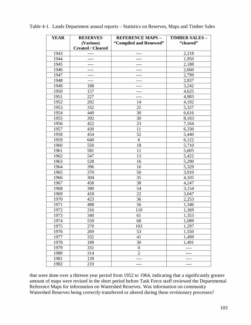
In Table 4.1, which shows data gathered from a long sequence of annual reports on how often the Lands Department either “compiled or renewed” it’s Departmental References Maps each audit year, 1972 marks the highest recorded instance since this reporting began in annual reports in about 1952, as 110 Reference Maps were added or revised in 1972 when Task Force staff retrieved information on the community watersheds, representing just over one third of the total number of Departmental Reference Maps in its entire BC-wide collection. Of note, over an eight year period from 1965 to 1972, the Department “compiled or renewed” 633 reference maps, compared to 239 100 For instance, Federal government and legal review processes have also revealed mysterious circumstances about the fate and alteration of a number of Federal Indian Reserves. 101 Page AA-50. 102 Pages BB 46-47.
103
Table 4-1. Lands Department annual reports – Statistics on Reserves, Maps and Timber Sales
that were done over a thirteen year period from 1952 to 1964, indicating that a significantly greater amount of maps were revised in the short period before Task Force staff reviewed the Departmental Reference Maps for information on Watershed Reserves. Was information on community Watershed Reserves being correctly transferred or altered during these revisionary processes?
104
Table 4.1 also presents another matter of intrigue, whereby it seems that the Forest Service may not have forwarded all the provincial Timber Sales as referrals to the Department of Lands for status referral purposes. Beginning in 1968, the total amount of Timber Sales cleared by the Department of Lands begins to sharply drop, despite the corresponding growing boom in BC’s timber industry. Concerns about how the Forest Service was not forwarding provincial Timber Sales as referrals for adjudication status clearance was raised in community watersheds Task Force memos in the mid-1970s. This matter raises serious questions of impropriety by the Forest Service, which may include concerns about how logging was occurring in Watershed Reserves, and perhaps also in other reserved tenured areas, without Crown tenure conflict clearance from the Lands Department. Another intriguing possibility about “the problem” raised in Ben Marr’s memo to the Deputy Forests Minister Stokes about the “missing” Reserves is that the matter may have been largely contrived as a hoax. For example, if it was found by the community watersheds Task Force that the Forest Service had for many years been logging in protected Watershed Reserves that were registered on Departmental Reference Maps as Map Reserves or Order-in-Council Reserves, it would inevitably have led to an internal investigation under the newly elected New Democratic Party (NDP) administration. Given the prominent attention and intense debates in the Legislature by the NDP opposition during the late 1960s about the Cypress Bowl logging scandal, where road access and clearcut logging above the Municipality of West Vancouver had occurred in an intact provincial Park and in a Watershed Reserve, new public controversies could erupt under similar scrutiny by the NDP administration. Given that daunting and earth shattering possibility – by falsely reporting to Task Force chair Ben Marr that most of the Watershed Reserves were missing – it was the best way out. However, that temporary solution to a looming internal problem would set up a new set of complicated problems by the creation, or re-creation, of Watershed Reserves (described below), and the sticky questions of how the Forest Service would deal with those problems as they would later unfold in the years to follow. 103 As far fetched as this scenario may seem, it has plausible and sobering merits when taking all the historical information into account – for instance, the summary information presented in annual reports that government staff were meticulously recording and transferring all the tenure and disposition license data onto Departmental Reference Maps. 103 See Chapter 7, in particular, Section 7.3, the strange fate and circumstances of Watershed Reserves.
105
Without the Reserves being registered on official planning maps, as Ben Marr notes in his April 1973 memo to Deputy Minister Stokes, the Lands Department cannot receive nor reject land use referrals, such as Timber Sales, in the referral or “adjudication process,” because the Water Rights Branch and Lands Department were ultimately responsible as final stewards to provincial water purveyors for what occurred in the Reserves. I.e., as stated in the BC Legislature on March 8, 1945 for domestic and irrigation watershed sources either reserved or not reserved under the Land Act:
Mr. King asked the Hon. the Minister of Lands the following questions: 1. What precautions are taken by the Department for the protection of watersheds which form a source of domestic and irrigation water-supply? The Hon. Mr. Kenney replied as follows: 1. Before any sale is made a joint report and recommendations are required of the District Forester and the District Engineer of the Water Rights Branch and due regard is paid to irrigation interests and domestic water users. 104
This transcript from the Legislature made in 1945 is an important clue to the overall awareness and long-held tradition of Watershed Reserves by senior departmental Crown resource administrators. Only a Watershed Reserve tenure status over community watersheds could prevent matters such as the alienation of land within them, as noted earlier in Chapter 2 regarding Superintendent of Lands Borthwick’s April 9, 1963 memo in the Rossland City Reserve file, where Borthwick flatly rejected an application for a cabin to be built in the protected watershed, and where Kamloops District Forester rejected a Timber Sale application in Revelstoke City’s Watershed Reserve over Greeley Creek. Without the Map Reserve or Order-in-Council Reserve instrument under the Land Act, community watersheds, which supplied wholesome drinking and needed irrigation water to British Columbians, would suffer threats.
How does the Lands Branch fit into the total organization of the British Columbia Lands Service of today? The relation may be expressed briefly. The Lands Branch has jurisdiction in matters pertaining to the disposition of Crown land, and is charged with so administering and disposing of the land that the general welfare, present and future, of the Province must be protected at all times. [Bold emphasis] The Lands Branch works in close co-operation with a great number of other agencies, such as municipal and city administrations, town-planning authorities, the British Columbia Forest Service, the Water Resources Service, the Surveys and Mapping Branch within the British Columbia Lands Service, and all the departments in the Government of the Province, notably Highways, Education, Attorney-General, and Agriculture. Direct service to the people of British Columbia is the first duty of the Lands Branch and this takes the bulk of the time of the Lands Branch personnel. Associated with this prime duty is the important function of the maintenance of the records, which in many cases are the only ones in British Columbia showing the correct legal status of the surface of the Province. 105
104 Journals of the Legislative Assembly of the Province of British Columbia, March 8, 1945. Question by Liberal Party MLA (Columbia Riding) Thomas King to Liberal Lands Minister E.T. Kenney (Skeena Riding). Comments made nearing the end of the Sloan Commission Inquiry on Forest Resources. 105 Annual Report of the British Columbia Lands Service, 1970, page AA-17.
106
4.1. Solving “The Problem”
1972 organizational chart of the Environmental and Land Use, and Technical, Committees Because the majority of the Province’s community Watershed Reserves were apparently not registered on the Lands Departmental Reference Maps under the administration of the Surveys Division, Task Force chairman Marr’s April 18, 1973 two-page memo concluded by recommending to Deputy Forests Minister Stokes, the chairman of the Environment and Land Use Technical Committee (ELUTC), that all BC’s community watersheds should therefore be automatically re-identified and recorded as Watershed Reserves:
The Task Force therefore recommends that map reserves be placed on the watersheds of community water supplies throughout the Province, excluding those of users whose source of supply is the main stem of a major river or lake, and excluding also spring and well users, who are essentially drawing on groundwater supplies. The approval of the Technical Committee to this recommendation is requested.
Subsequent Task Force meeting minutes and memos confirm that in the following month, May 1973, the provincial ELUTC of Deputy Ministers, under directives and authority of the 1971 Environment and Land Use Act, collectively authorized the formal establishment and implementation of Province-wide Watershed Map Reserves for all the community watersheds that were identified by the Task Force. These Reserves were then systematically registered (and/or re-registered, as described below) over the following seven months on all Departmental Reference Maps.
107
An unknown number of these Map Reserves established from 1973 following had already been established, and were being re-reserved, a few of which had been classified as Order-in-Council Reserves. However, as explained below in section 4.3, it took a little longer to register the Watershed Reserves on some of the Forest Service District (Region) office Forest Atlas Reference Maps, as a number of foresters were politically opposed to the Watershed Reserves implementation orders by the ELUTC. Some nine months before ELUTC authorized the Watershed Reserve orders, there occurred a significant political event whereby the twenty-year long Social Credit Party administration (1952-1972) was defeated in the provincial election of August 30, 1972, and a new government resource philosophy and policy under the New Democratic Party took hold for just over three years.
The accession to power of the N.D.P. Government in August of 1972 signalled a much broader interpretation of the scope of the Environment and Land Use Act [of 1971]. The new Government’s election platform had included special emphasis on environmental and planning issues. There were indications that a provincial “Department of the Environment” might be established…. The new political climate in the Province since August of 1972 has provided the B.C. Public Service with new degrees of freedom and a receptive political ear in the areas of environment, land use and resources policy. 106
During this shift of fundamental administrative readjustment of provincial land use planning objectives and policies (September 1972 to December 1975) is when professional foresters in the Forest Service actively rebelled against initiatives that challenged their collective shenanigans about logging in community watersheds ongoing since the early 1960s. In addition to the intrusion into community watersheds, the Forest Service had also been responsible for degrading salmon and fresh water fish habitat streams since the 1940s, despite ongoing internal criticism from federal fisheries officers and inspectors. On June 26, 1973, Task Force chairman Ben Marr (the Chief Engineer of the Water Investigations Branch) instructed C.W. House, the administrator of BC’s Reserves in the Land Administration Division in Victoria, to establish 64 community Watershed Reserves in the Revelstoke, Kaslo and Nelson Water Districts in southeast BC, representing three of the Province’s 27 Water Districts. 107 Marr’s three-page informational memo to the Reserves administrator included all the essential data needed on the 64 community watershed sources, such as the name of the water source and the Water District, the surface area of the watershed, the identity of the water license purveyor, and individual map reference numbers assigned to newly formed Watershed Reserve location maps. The Water Investigations Branch also forwarded two sets of large and small scale maps of the Watershed Reserves to C.W. House identifying both the map boundaries of the Reserves and the Watershed Reserve numbers, the same maps and identifications appended seven years later as Appendix G in the October 1980 ‘Blue Book,’ Guidelines for Watershed Management of Crown Lands Used as Community Water Supplies. 106 Pages xxix to xxxi, Environment and Land Use Policies and Practices of the Province of British Columbia, Volume 1, 1975 by Christianna Stachelrodt Crook. 107 See Water Districts map at the beginning of this report. By the late 1960s, a number of the Water Districts were re-amalgamated and reduced by five, totalling from 32 in 1946 to 27 in the late 1960s.
108
Right: Lands Department administration tree with C.W. House as Reserves administrator. Other similar letters of instruction for Map Reserve establishment sent by the Task Force to Reserves Manager House would soon follow. For instance, on August 14, 1973, House received a request to establish 60 Map Reserves in two more Water Districts, the Vancouver and New Westminster Water Districts. By August 1973, requests were in to establish Reserves in 20 of BC’s 27 Water Districts. And, by the end of the year requests were in to Map Reserve all the community watersheds the Task Force had so far identified, some 300 in number. As later instructed, whenever a new community watershed was established or registered, the Lands Department was ordered to automatically make it a Watershed Map Reserve. 108
108 Government records show that these Reserves were still being created throughout the 1980s.
109
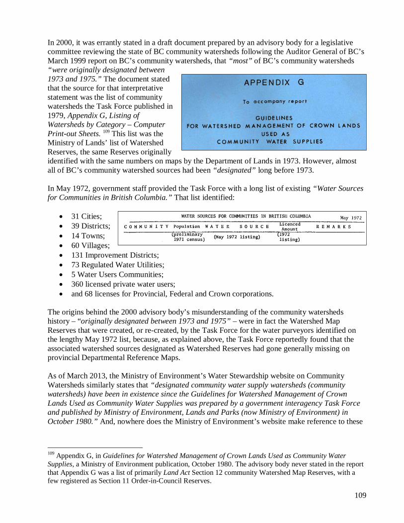
In 2000, it was errantly stated in a draft document prepared by an advisory body for a legislative committee reviewing the state of BC community watersheds following the Auditor General of BC’s March 1999 report on BC’s community watersheds, that “most” of BC’s community watersheds “were originally designated between 1973 and 1975.” The document stated that the source for that interpretative statement was the list of community watersheds the Task Force published in 1979, Appendix G, Listing of Watersheds by Category – Computer Print-out Sheets. 109 This list was the Ministry of Lands’ list of Watershed Reserves, the same Reserves originally identified with the same numbers on maps by the Department of Lands in 1973. However, almost all of BC’s community watershed sources had been “designated” long before 1973. In May 1972, government staff provided the Task Force with a long list of existing “Water Sources for Communities in British Columbia.” That list identified:
31 Cities; 39 Districts; 14 Towns; 60 Villages; 131 Improvement Districts; 73 Regulated Water Utilities; 5 Water Users Communities; 360 licensed private water users; and 68 licenses for Provincial, Federal and Crown corporations.
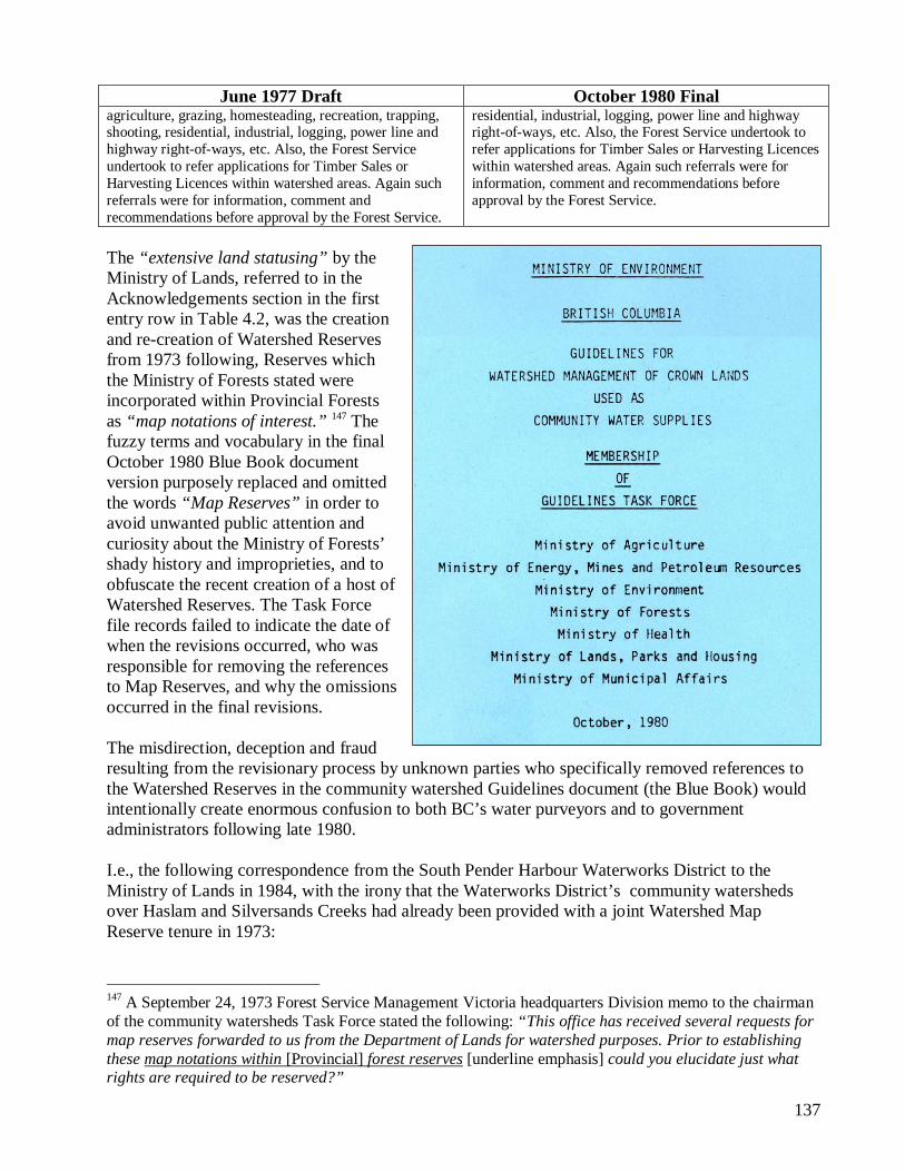
The origins behind the 2000 advisory body’s misunderstanding of the community watersheds history – “originally designated between 1973 and 1975” – were in fact the Watershed Map Reserves that were created, or re-created, by the Task Force for the water purveyors identified on the lengthy May 1972 list, because, as explained above, the Task Force reportedly found that the associated watershed sources designated as Watershed Reserves had gone generally missing on provincial Departmental Reference Maps. As of March 2013, the Ministry of Environment’s Water Stewardship website on Community Watersheds similarly states that “designated community water supply watersheds (community watersheds) have been in existence since the Guidelines for Watershed Management of Crown Lands Used as Community Water Supplies was prepared by a government interagency Task Force and published by Ministry of Environment, Lands and Parks (now Ministry of Environment) in October 1980.” And, nowhere does the Ministry of Environment’s website make reference to these
109 Appendix G, in Guidelines for Watershed Management of Crown Lands Used as Community Water Supplies, a Ministry of Environment publication, October 1980. The advisory body never stated in the report that Appendix G was a list of primarily Land Act Section 12 community Watershed Map Reserves, with a few registered as Section 11 Order-in-Council Reserves.
110
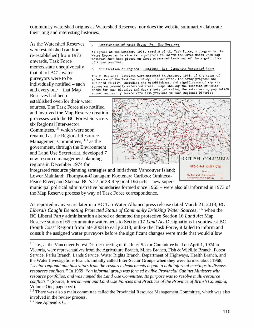
community watershed origins as Watershed Reserves, nor does the website summarily elaborate their long and interesting histories. As the Watershed Reserves were established (and/or re-established) from 1973 onwards, Task Force memos state unequivocally that all of BC’s water purveyors were to be individually notified – each and every one – that Map Reserves had been established over/for their water sources. The Task Force also notified and involved the Map Reserve creation processes with the BC Forest Service’s six Regional Inter-sector Committees,110 which were soon renamed as the Regional Resource Management Committees, 111 as the government, through the Environment and Land Use Secretariat, developed 7 new resource management planning regions in December 1974 for integrated resource planning strategies and initiatives: Vancouver Island; Lower Mainland; Thompson-Okanagan; Kootenay; Cariboo; Omineca-Peace River; and Skeena. BC’s 27 or 28 Regional Districts – new super-municipal political administrative boundaries formed since 1965 – were also all informed in 1973 of the Map Reserve process by way of Task Force correspondence. As reported many years later in a BC Tap Water Alliance press release dated March 21, 2013, BC Liberals Caught Demoting Protected Status of Community Drinking Water Sources, 112 when the BC Liberal Party administration altered or demoted the protective Section 16 Land Act Map Reserve status of 65 community watersheds to Section 17 Land Act Designations in southwest BC (South Coast Region) from late 2008 to early 2013, unlike the Task Force, it failed to inform and consult the assigned water purveyors before the significant changes were made that would allow 110 I.e., at the Vancouver Forest District meeting of the Inter-Sector Committee held on April 1, 1974 in Victoria, were representatives from the Agriculture Branch, Mines Branch, Fish & Wildlife Branch, Forest Service, Parks Branch, Lands Service, Water Rights Branch, Department of Highways, Health Branch, and the Water Investigations Branch. Initially called Inter-Sector Groups when they were formed about 1968, “senior regional administrators from the resource departments began to hold informal meetings to discuss resources conflicts.” In 1969, “an informal group was formed by five Provincial Cabinet Ministers with resource portfolios, and was named the Land Use Committee. Its purpose was to resolve multi-resource conflicts.” (Source, Environment and Land Use Policies and Practices of the Province of British Columbia, Volume One, page xxvi). 111 There was also a main committee called the Provincial Resource Management Committee, which was also involved in the review process. 112 See Appendix C.
111
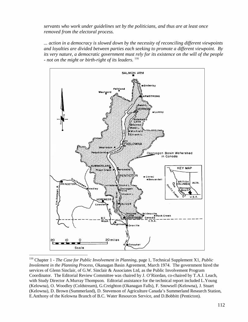
‘discretionary’ permitting of commercial resource activities and tenures by resource administrators with the Ministry of Environment. Unfortunately, though the Terms of Reference established for the Task Force in early 1972 never included public participation or coordinated public involvement in the Task Force review process, the “public” was merely informed by way of correspondence sent to individual water purveyor Trustees and administrators, and to Regional District administrators. 4.2. The 1969-1974 Okanagan Basin Study In 1973, community watersheds Task Force Chair Ben Marr, the Chief Engineer of the Water Investigations Branch, was acutely aware of the critical nature of public involvement in the land resource planning affairs of government, and was undoubtedly aware that a public involvement process had been excluded from the Task Force Terms of Reference. 113 The political decision to avoid public involvement in the Task Force review process by the Social Credit Party administration was most likely related to an intense and successful public involvement program underway at that time in the Okanagan Basin in BC’s Southern Interior. In October 1969, Scotland-born and university educated Marr had been assigned to co-chair a lengthy provincial / federal joint public review of the Okanagan’s water resources (1969-1974), most likely the reason he was later assigned by the Environment and Land Use Technical Committee to chair the community watersheds Task Force that began in February 1972. The Okanagan study was the first comprehensive and intensive public participation resource planning review of its kind in Canada, 114 formed when both the United States and Canada began introducing new environmental and public involvement legislations and policies. In May 1974, some six thousand pages of multi-disciplinary information were published in a final Okanagan report which included twelve thick technical study supplement reports. 115 Other government representatives who were involved in the community watersheds Task Force also participated in the Okanagan Basin Studies, as many provincial ministries / departments were called in to assist in the intense multi-disciplinary study process, and were therefore very familiar with its study objectives. A critical, dedicated account of the public involvement process was detailed in a separate 485-page technical supplement:
Planning studies compound the problem further for the citizen because, while such studies are initiated and authorized by the politicians, the personnel for the most part are civil
113 I.e., the following quote from the Task Force Meeting minutes of May 15, 1972, Board Room, Water Resource Service, Victoria: “(11.) Mr. Marr asked the Committee to consider whether it was possible to undertake its work within the represented departments or whether it would be necessary to involve local organizations operating water supply systems.” 114 “The first major study in the field of comprehensive river-basin planning attempted in Canada.” Source: BC Water Resources Department Annual Report, 1971, page 49. 115 Canada-British Columbia Okanagan Basin Agreement, Main Report of the Consultative Board, March 1974. On page 475 of the Main Report, “Prior to this study, the public has had no opportunity for participation in the planning process.” A critical account of the Okanagan Basin study process, along with summaries by professionals on the importance of public involvement, was detailed in a 485 page technical supplement to the March 1974 Main Report document, Technical Supplement X1, Public Involvement in the Planning Process.
112
servants who work under guidelines set by the politicians, and thus are at least once removed from the electoral process. ... action in a democracy is slowed down by the necessity of reconciling different viewpoints and loyalties are divided between parties each seeking to promote a different viewpoint. By its very nature, a democratic government must rely for its existence on the will of the people - not on the might or birth-right of its leaders. 116
116 Chapter 1 - The Case for Public Involvement in Planning, page 1, Technical Supplement X1, Public Involement in the Planning Process, Okanagan Basin Agreement, March 1974. The government hired the services of Glenn Sinclair, of G.W. Sinclair & Associates Ltd, as the Public Involvement Program Coordinator. The Editorial Review Committee was chaired by J. O’Riordan, co-chaired by T.A.J. Leach, with Study Director A.Murray Thompson. Editorial assistance for the technical report included L.Young (Kelowna), O. Woodley (Coldstream), G.Creighton (Okanagan Falls), F. Snowsell (Kelowna), J. Stuart (Kelowna), D. Brown (Summerland), D. Stevenson of Agriculture Canada’s Summerland Research Station, E.Anthony of the Kelowna Branch of B.C. Water Resources Service, and D.Bobbitt (Penticton).
113
A complex methodology of approach for public involvement, referred to as the “Sinclair Model”, was designed by the inter-governmental Study Committee through an Alberta-based consultant agency in the Spring of 1972 “to obtain better communication between the study and the public interest groups.” 117 According to a summary of public involvement in chapter 10 of the Main Okanagan Basin Report, the development of the Sinclair Model was predicated on formal public hearings the Okanagan Basin Agreement Consultative Board convened in November 1970. Shortly thereafter, the Board met with local members of the Okanagan Basin Water Board at their headquarters office in Kelowna, where the Kelowna members:
raised the question of how public interests, values and desires would be incorporated into the development of a framework plan for the management of the water resources of the basin. It was mutually agreed that both Boards had an interest in obtaining public responses to questions of water and related resources management and that they would share the results of their respective programs.
Given the controversial history of logging in the Okanagan (narrated in Chapter 2.3), commercial logging (‘forest management’) was oddly the only land resource theme/issue that had been specifically excluded from the Okanagan Basin study’s 1969 Terms of Reference, Terms that defined how the study was to comprehensively assess impacts on the Okanagan’s collective water resources. It took about three years before the general public noted the discrepancy. During the numerous open public dialogues and debates that local radio and television stations hosted as part of the provincial and federal governments Okanagan Basin study process, it was in November 1972 that angry concerns were raised about how logging went unaccounted for in the inter-governmental Basin studies, and how it was creating havoc on the Okanagan’s landscape and water resources. And, it wasn’t until 1973 that the logging issue became a formally documented concern by the Okanagan Basin Community Task Force No. 7, with its Basin-wide 24 member representatives. In its final observations and recommendations to the government, Task Force 7 simply stated, “[though] the Okanagan Basin Study was established to examine specifically water resources, we have found that land use has such an effect on water quality and quantity, that it has to be taken into account.” 118 The internal concerns about the missing component and review of forest management (clearcut logging) practices and their controversial relationships to water quality and quantity prompted the Okanagan Basin Study program organizers in 1972 to contract a recent forest hydrology PhD graduate from the University of BC’s forestry faculty, Bob Willington, to fill in the critical informational gap by way of a report study. Technical Supplement No. 1 of the final Okanagan Basin report included an appendix with a 70-page report by Willington, and two professional foresters, D.S. Jamieson and M.D. Godfrey, Evaluation of Watershed Deforestation and Harvesting Practices in the Okanagan Basin. Instructions to the forest hydrology researchers by the Basin Study Committee were to provide four outcomes in Task 180:
1. To outline zones where timber harvesting has produced conflicts of interest such as fishery, domestic water supply and grazing.
117 Page 251, Main Report of the Consultative Board. 118 Technical Supplement XI, Public Involvement, page 123.
114
2. To provide a preliminary evaluation of the effects of timber harvesting on water quantity and quality by zone. Limitations to harvesting rates imposed by sustained yield to be incorporated insofar as assigning significant effects (10%) on water quantity and quality to various zones. 3. To indicate zones in which forest harvesting might incite major problems of erosion and nutrient leaching as a consequence of roads and/or harvesting technique. 4. Characterize a selected watershed into major biophysical zones and tabulate, by zone, the present and future harvesting rates.
However, contrary to the instructions to the report researchers, there was no information provided in their final report on outlining “zones of conflicts of interest in domestic water supply” sources. These “conflicts” were key concerns linked to the government’s recent imposition of sustained yield logging and rate of cut in the Okanagan Basin through the establishment of the Okanagan Sustained Yield Unit No. 47 in 1963 (see below), which included the domestic and irrigation sources on many lands that were supposedly and conditionally reserved from logging. The north Okanagan area near Kelowna City was the electoral riding of BC’s Social Credit Party Premier, W.A.C. Bennett, elected to office since 1952. Willington’s hydrology report was not based on long-term and in-depth instrumental and analytical scientific evaluations of lands in the Okanagan, but was based on a ‘hypothetical’ experiment on the unlogged 20 square mile Pearson Creek watershed, a tributary basin to the Mission Creek watershed located in the upper mid-eastern slopes of the northeast Okanagan Basin (east of Kelowna City). The so-called “experiment” provided theoretical predictions on water runoff increases from clearcut logging practices, predictions based entirely on modelling equations recently generated from United States experimental forest hydrology studies:
Water yield increases accruing from forest harvesting in the Okanagan Basin were estimated using modelling techniques and extrapolations of research findings from comparable regions.... Interpretation of the data must be carried out very cautiously to avoid proliferation or creation of any more myths. 119
What did logging activities promoted through forest management recommendations by forest hydrology experiments have in any way to do with logging in supposedly protected Watershed Reserves? They didn’t, because logging was to be excluded in these Map Reserves. And, when a formal, long-term BC government forest hydrology experiment later began in the headwaters of Penticton Creek in the 1980s, the source of drinking water for Penticton City, where American giant Weyerhaeuser was logging, the experiment also took place in a supposedly protected Watershed Map Reserve. 120 And, as elsewhere, nowhere in the Penticton Creek logging experiment brochure materials or reporting by government was there any reference made to the Penticton Creek watershed area being a Watershed Reserve, nor what such a provincial government policy or legislation entailed, namely the exclusion of logging and road construction.
119 Page 534. Willington’s reference to “myths” is from the opening Summary paragraph of his report where he states that, “It must be stressed that forestry has earned a poor reputation in the Basin through the proliferation of certain mythological aspects of its effect on streamflow such as: logging dries up streams, logging causes floods.” 120 The Map Reserve active tenure status of the Penticton Creek watershed seems to have disappeared from the government’s data list of community Watershed Reserves.
115
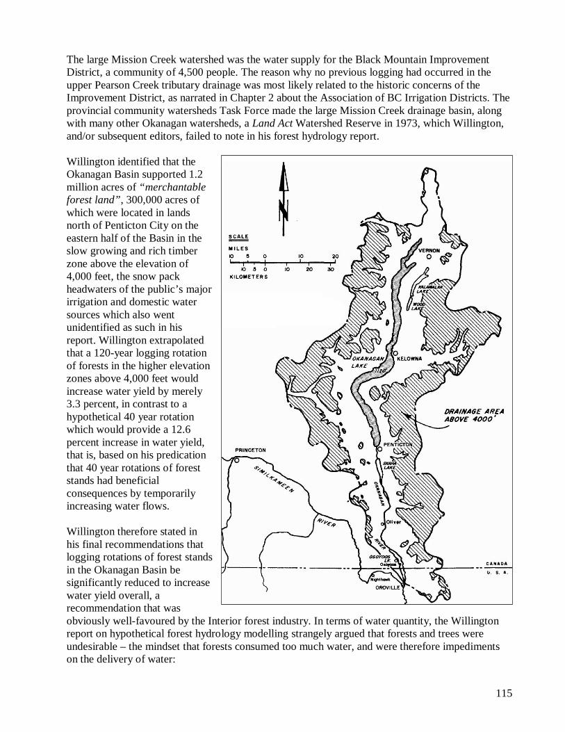
The large Mission Creek watershed was the water supply for the Black Mountain Improvement District, a community of 4,500 people. The reason why no previous logging had occurred in the upper Pearson Creek tributary drainage was most likely related to the historic concerns of the Improvement District, as narrated in Chapter 2 about the Association of BC Irrigation Districts. The provincial community watersheds Task Force made the large Mission Creek drainage basin, along with many other Okanagan watersheds, a Land Act Watershed Reserve in 1973, which Willington, and/or subsequent editors, failed to note in his forest hydrology report. Willington identified that the Okanagan Basin supported 1.2 million acres of “merchantable forest land”, 300,000 acres of which were located in lands north of Penticton City on the eastern half of the Basin in the slow growing and rich timber zone above the elevation of 4,000 feet, the snow pack headwaters of the public’s major irrigation and domestic water sources which also went unidentified as such in his report. Willington extrapolated that a 120-year logging rotation of forests in the higher elevation zones above 4,000 feet would increase water yield by merely 3.3 percent, in contrast to a hypothetical 40 year rotation which would provide a 12.6 percent increase in water yield, that is, based on his predication that 40 year rotations of forest stands had beneficial consequences by temporarily increasing water flows. Willington therefore stated in his final recommendations that logging rotations of forest stands in the Okanagan Basin be significantly reduced to increase water yield overall, a recommendation that was obviously well-favoured by the Interior forest industry. In terms of water quantity, the Willington report on hypothetical forest hydrology modelling strangely argued that forests and trees were undesirable – the mindset that forests consumed too much water, and were therefore impediments on the delivery of water:
116
The goals of management for maximum water yield are to reduce the water consumed by the forest, maintain the permeable soil structure, and rearrange snowfall so that it more effectively contributes to streamflow. The forest environment and the processes governing it are important, not the trees themselves. Enough foliage must be grown to protect the soil, but it can come from small trees or other plants. 121
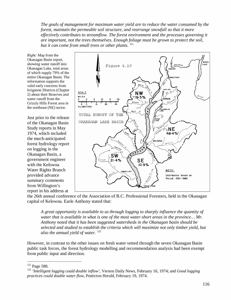
Right: Map from the Okanagan Basin report, showing water runoff into Okanagan Lake, total areas of which supply 79% of the entire Okanagan Basin. The information supports the valid early concerns from Irrigation Districts (Chapter 2) about their Reserves and water runoff from the Grizzly Hills Forest area in the northeast (NE) sector. Just prior to the release of the Okanagan Basin Study reports in May 1974, which included the much-anticipated forest hydrology report on logging in the Okanagan Basin, a government engineer with the Kelowna Water Rights Branch provided advance summary comments from Willington’s report in his address at the 26th annual conference of the Association of B.C. Professional Foresters, held in the Okanagan capital of Kelowna. Earle Anthony stated that:
A great opportunity is available to us through logging to sharply influence the quantity of water that is available in what is one of the most water-short areas in the province… Mr. Anthony noted that it has been suggested watersheds in the Okanagan basin should be selected and studied to establish the criteria which will maximize not only timber yield, but also the annual yield of water. 122
However, in contrast to the other issues on fresh water vetted through the seven Okanagan Basin public task forces, the forest hydrology modelling and recommendation analysis had been exempt from public input and direction.
121 Page 588. 122 ‘Intelligent logging could double inflow’, Vernon Daily News, February 16, 1974; and Good logging practices could double water flow, Penticton Herald, February 19, 1974.
117
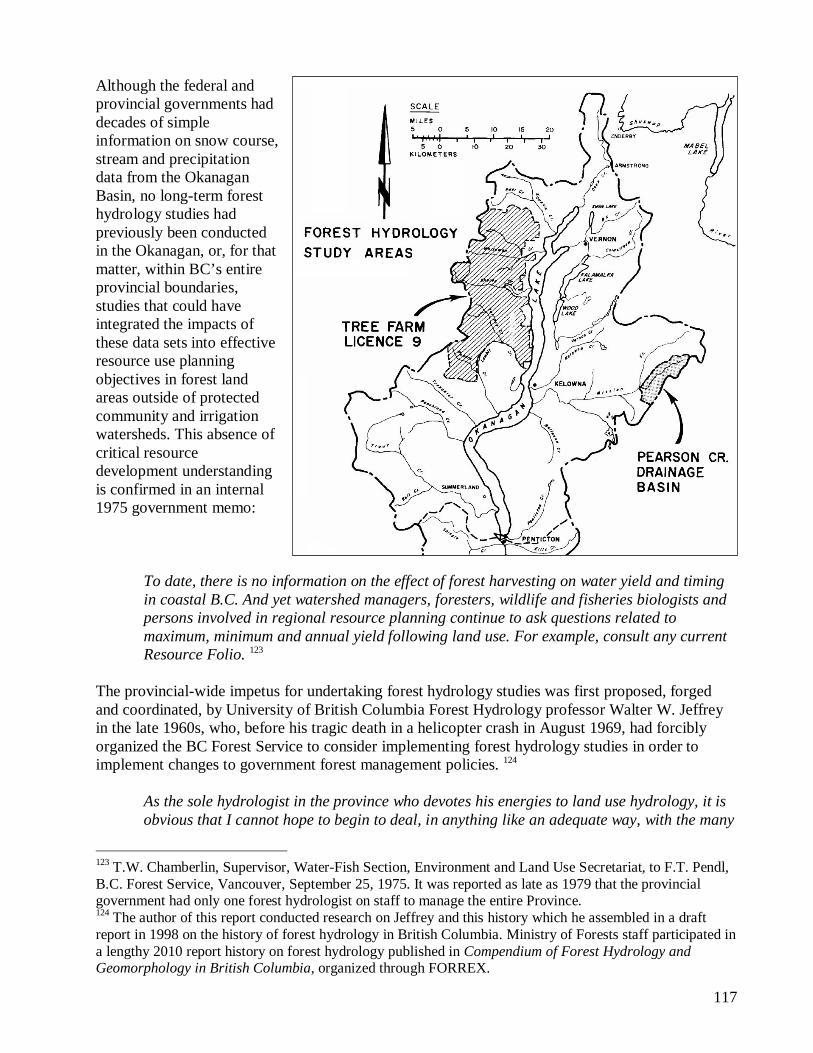
Although the federal and provincial governments had decades of simple information on snow course, stream and precipitation data from the Okanagan Basin, no long-term forest hydrology studies had previously been conducted in the Okanagan, or, for that matter, within BC’s entire provincial boundaries, studies that could have integrated the impacts of these data sets into effective resource use planning objectives in forest land areas outside of protected community and irrigation watersheds. This absence of critical resource development understanding is confirmed in an internal 1975 government memo:
To date, there is no information on the effect of forest harvesting on water yield and timing in coastal B.C. And yet watershed managers, foresters, wildlife and fisheries biologists and persons involved in regional resource planning continue to ask questions related to maximum, minimum and annual yield following land use. For example, consult any current Resource Folio. 123
The provincial-wide impetus for undertaking forest hydrology studies was first proposed, forged and coordinated, by University of British Columbia Forest Hydrology professor Walter W. Jeffrey in the late 1960s, who, before his tragic death in a helicopter crash in August 1969, had forcibly organized the BC Forest Service to consider implementing forest hydrology studies in order to implement changes to government forest management policies. 124
As the sole hydrologist in the province who devotes his energies to land use hydrology, it is obvious that I cannot hope to begin to deal, in anything like an adequate way, with the many
123 T.W. Chamberlin, Supervisor, Water-Fish Section, Environment and Land Use Secretariat, to F.T. Pendl, B.C. Forest Service, Vancouver, September 25, 1975. It was reported as late as 1979 that the provincial government had only one forest hydrologist on staff to manage the entire Province. 124 The author of this report conducted research on Jeffrey and this history which he assembled in a draft report in 1998 on the history of forest hydrology in British Columbia. Ministry of Forests staff participated in a lengthy 2010 report history on forest hydrology published in Compendium of Forest Hydrology and Geomorphology in British Columbia, organized through FORREX.
118
problems that exist. … greater attention to land use hydrology is inevitable as Canada develops, and the associated recognition that no Canadian university presently devotes any significant attention to the hydrology of land use. Recruitment of hydrologists specialising in this field is thereby totally dependent upon the output of U.S. institutions. 125
By 1972, experimental forest hydrology studies were being established in both the Seymour watershed north of Vancouver City – where controversial roadbuilding and clearcut logging was starting in earnest in the Greater Vancouver Water District’s formerly protected three watersheds – and in the Carnation Creek study area near Bamfield on southwest Vancouver Island, where forestry giant MacMillan Bloedel was logging. Both the Jamieson/Elbow experiment in the Seymour watershed and Carnation Creek experiment ended up in failure, as reported in the 1990s by both the author of this report and by well-known federal fisheries experts. While these forest hydrology experiments were conducted over a period of two decades they largely failed to influence forest management practices in BC. 126 A year after the conclusion of the Okanagan Basin studies, the Okanagan Similkameen Parks Society published a scathing 30-page booklet in 1975, Is Everything All Right up There? It included numerous aerial photographs and maps showing the large clearcuts and where
125 Hydrology of Greater Vancouver Municipal Watersheds, First Draft, December 6, 1968, by W.W. Jeffrey. 126 Similar, but much earlier, forest hydrology precedent experiments were launched in the late 1950s by the U.S. Forest Service in Portland City’s Bull Run watershed, where logging was supposedly forbidden by U.S. federal law. A federal court judge stated in a March 1976 judgement that the U.S. Forest Service had been conducting illegal forest harvesting and road access in the Bull Run Watershed Reserve, soiling the credibility of the Forest Service and its forest hydrology experiments.
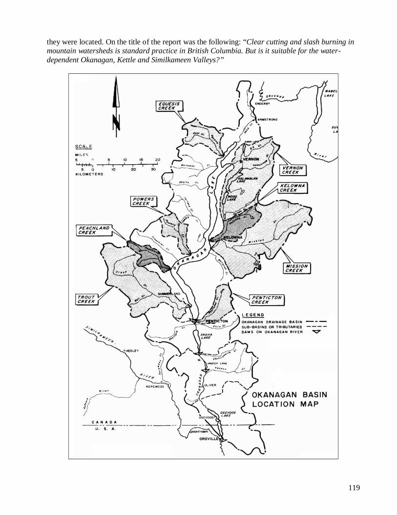
119
they were located. On the title of the report was the following: “Clear cutting and slash burning in mountain watersheds is standard practice in British Columbia. But is it suitable for the water-dependent Okanagan, Kettle and Similkameen Valleys?”
120
4.2.a. Okanagan Basin Logging History Statements made by BC Water Comptroller E.R. Davis in the 1944-1945 BC Forest Commission Inquiry transcripts indicate there had been very little logging within the Okanagan Basin area since 1910. 127 The Forest Service’s annual report for 1914 summarized that the Okanagan was a complicated maze of irrigation systems, where “practically all available water, which can be taken by gravity from the ordinary flow of streams emptying into the Okanagan, has been utilized:”
The experience of other countries has shown that the forest cover on mountain watersheds has a most important influence on conserving and maintaining the flow of water. It increases the storage capacity of the soil, retards the spring thaw, and prevents excessively rapid run-off, and consequently lengthens and extends the period of maximum flow of streams. These [high elevation forests] are the timbered watersheds on whose maintenance depend the water-supply for the irrigated land in the valleys. 128
The coloured forest cover map attached in the 1930 Forest Surveys Division report, R 33 - Okanagan Forest 1930, also showed that on the western half of the Okanagan Lake watershed basin complex very little logging had occurred. Forest Survey report No. R 76, Proposed Okanagan Working Circle – Forest Survey and Preliminary Management Plan 1938-1939, indicated much the same, how the higher elevation forests were still in a relatively undisturbed state. F.D. Mulholland’s Forest Resources report of 1937, that included comprehensive sets of logging data for every sub-landscape forest boundary unit for each Forest District in the Province, stated that out of the total 2,067,800 acres identified as falling within the Okanagan Basin drainage boundary, only 18,700 acres had been logged to date. The first serious ‘intrusion’ test case set up by the Forest Service in the publically sensitive Okanagan Basin complex was the establishment of Forest Management License (Tree Farm License, or TFL) No. 9 on the northwest side of Okanagan Lake in 1951, awarded to S.M. Simpson Ltd., a license initially called Okanagan West. Dedicated as a Private Working Circle, it was a large tract of public forest lands, mixed with some private land holdings, some 195,000 total acres in area, rising from the shoreline of Okanagan Lake straight up to the high country divide to the west, extending north from the Lambly Creek watershed just west of Kelowna City, north to the Naswhito Creek watershed, just west of Vernon City. 129
127 Sloan Commission transcripts, Volume 3, page 796. 128 Page 55. 129 In 1970, Tree Farm License 9 was sold to Crown Zellerbach Canada Ltd., as was Tree Farm License 16 (the “Monte Lake” Tree Farm), located immediately west of Tree Farm 9, about 129,000 acres in area, making both Tree Farms into a combined single unit of some 324,000 acres. As part of an aggressive strategy, Zellerbach also acquired Tree Farm License 32 (the “Bolean” Tree Farm), some 33,000 acres in area, not far to the north of Tree Farm 9. In 1983, Fletcher Challenge Limited acquired the rights of the three Tree Farm Licenses from Crown Zellerbach, and renamed the rights as Crown Forest Industries Limited. In
121
As reported in TFL No. 9 Working Plan Number 3 report, published by S.M. Simpson Ltd. in February 1963, it listed the holders of water licenses within the limits of TFL No. 9, which included the Westbank Irrigation District:
The section of the Okanagan Lake watershed encompassed by the Licence area is of importance for water conservation purposes to the agricultural community of the valley. During the spring run-off when enormous amounts of water are released from the watershed, dammed lakes are filled with water for subsequent use for irrigation purposes. The water is released into creeks as required and then piped and flumed to fruit orchards and vegetable growing areas for summer irrigation. The main irrigation system lies in the Lambly (Bear) Creek drainage system which supplies water to the Westbank area. The Powers Creek Irrigation system is also partially dependent on water from the Licence area. An application by the Vernon Band of Indians and J. R. and C.G. Lidstone proposes development of the Bouleau Creek system for irrigation purposes. The significance of the water conservation role of the water-shed is not restricted to irrigation collection. Cases of landslip due to incorrect logging practices and gully erosion by cloudbursts have occurred in the past. The maintenance of the soil cover is important to forestry, as is the prevention of silting up of storage lakes and waterways. No conflict of any magnitude exists at the moment between water users and the management of the forest. There has been and is considerable anxiety amongst some orchardists and their organizations over the effects of logging and fires on water conservation. There is little doubt, however, that proper forestry practices as required by the Tree Farm Licence contract and the provisions of the Management and Working Plans are an adequate safeguard and are certainly far superior to such arrangements as existed prior to the inception of sustained yield forestry in the area [bold emphasis]. 130
By 1963, Stanley M. Simpson, the head of S.M. Simpson Ltd., was a senior member of the Interior Lumber Manufacturers Association, and had amassed a small host of timber holdings under his company name, for both a source of timber supply and for various timber processing mills then operating in the Okanagan area: S&K Ltd., Trautman-Garraway Ltd., Lumby Timber Co. Ltd., Peachland Sawmill & Box Co. Ltd., McLean Sawmills Ltd., Fergusion Bros. Lumber Ltd., and Stave Lumber Co. Ltd. 131
1988 Fletcher Challenges’ entire holdings, that included the assets of BC Forest Products, were renamed Fletcher Challenge Canada Limited, and Crown Zellerbach’s three Tree Farm Licenses in the north Okanagan were renamed as Tree Farm License 49. In 1992, Riverside Forest Products acquired the rights to Tree Farm 49, which was sold again to Tolko Industries in 2004. 130 Ibid., pages 21-22. 131 Ibid., pages 29-30. See also Sharron J. Simpson’s book, Boards, Boxes and Bins: Stanley M. Simpson and the Okanagan Lumber Industry.
122
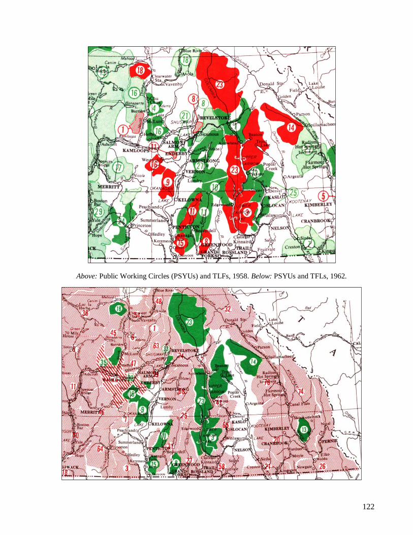
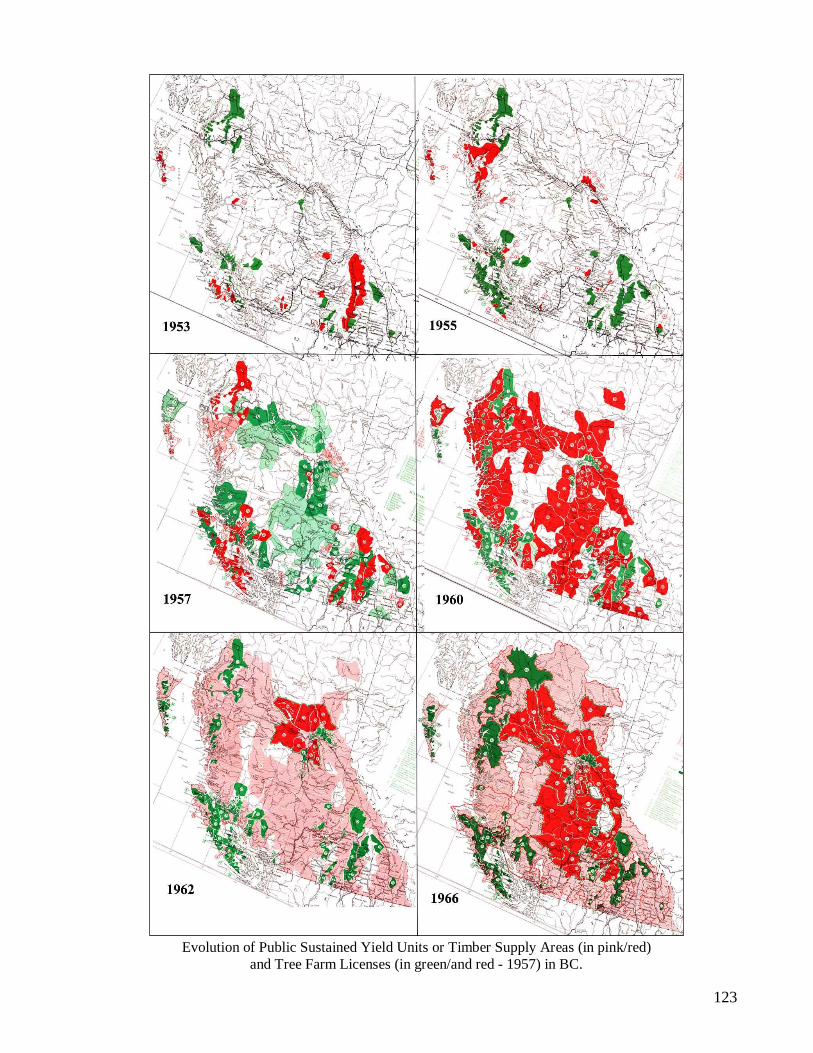
Above: Public Working Circles (PSYUs) and TLFs, 1958. Below: PSYUs and TFLs, 1962.
123
Evolution of Public Sustained Yield Units or Timber Supply Areas (in pink/red) and Tree Farm Licenses (in green/and red - 1957) in BC.
124
By 1953, a second Forest Management License No. 15 was awarded to Oliver Sawmills Ltd., some 120,000 acres in area, located southeast of Penticton City in the mid to high elevation forestlands and extending southwards just east of the Town of Oliver. Given the internal BC Forest Service politics about logging in drinking and irrigation watersheds, it is interesting to observe the evolution of the establishment of Tree Farm Licenses and Public Working Circle / Public Sustained Yield Units (PSYUs) throughout the Province of BC, illustrated on provincial Forest Service maps from 1953 to 1966, published in the Forest Service annual reports (compiled together and shown on the previous page). By 1962, there remained only two unmanaged blank or white zones in southern British Columbia not assigned sustained yield logging legal survey boundaries: in the Okanagan Basin, and in the Kootenay Lake area, where many communities and Irrigation Districts had their drinking watersheds. By 1963, the Forest Service established the 1,864,701 acre Okanagan PSYU No. 47, “the last unmanaged area in the Kamloops Forest District.” 132 By 1966, the last remaining blank or unmanaged area was filled in by the establishment of the Lardeau PSYU No. 33 over the Kootenay Lake area. In his forest hydrology modelling report for the Okanagan Basin Study, Willington documented in Tables III-1 to III-6 both the amounts of commercial logging in the two Okanagan Basin Tree Farm Licenses (45,000 million cubic feet harvested from 1960-1971), and the clearcutting by forest licensees within the 3,100 square mile Okanagan watersheds basin that began in 1964 in the newly assigned Okanagan PSYU. Many of the watersheds were largely unlogged, where some had been supposedly protected as Watershed Reserves: i.e., a Watershed Reserve was established Penticton Creek in 1936, and another larger Reserve was established in late 1964 encompassing both Ellis and Penticton Creek watersheds. As narrated in Chapter 2, 1963 was the same year when Chief Forester McKinnon sent out a memo to his Nelson Regional Foresters about “the problem of protection.” From 1964 to 1971, a total of 41,000 acres had been logged in the Okanagan Unit, about 30,000 acres logged just before the Okanagan Basin Terms of Reference was signed in October 1969. In a seven year period from 1964-1971, the amount of lands logged in the Okanagan PSYU (excluding lands logged in the two Tree Farm Licenses) more than doubled the total area of lands logged since logging first began in the Okanagan up until 1937.
132 B.C. Forest Service Annual report, 1963.
125
New access roads were frantically bulldozed into the heart of BC’s web of pristine watersheds, eventually penetrating the high country plateau headwater forests on the east and west slopes of the Okanagan, a sensitive political issue for many water purveyors and irrigation Trustees, as these were the slow growing and rich timber zones, the snow pack headwaters of the major irrigation and domestic water sources.
The Okanagan River watershed is a wide glaciated valley that forms a deep north-south cut in the high Thompson plateau in the British Columbia interior. The region is shielded from westerly storms by the Cascade Mountains, and experiences a semi-arid climate that provides only limited amounts of surface runoff. Most of the runoff appears to result from depletion of the heavy winter snowpacks at the high plateau elevations, and only small amounts of runoff appear to come from elevations below 4,000 feet. 133
The building of new forest access roads throughout British Columbia over a forty-five year period, from 1952 to 1997, would create a unprecedented network of more than 500,000 kilometres of logging roads, enough to circle the globe some twelve or more times. While stimulating BC’s economy and providing unprecedented volumes of raw timber primarily for export, the road complexes built into pristine watersheds to access valley bottom, mid and high elevation forest lands, combined with clearcutting on flat to very steep slopes, would create mountains of problems: millions of tonnes of sediments eroded, landslides, concentration of water runoff, flooding, etc. By removal slicing of soil horizons (“cutslopes” and “ditching”), roads altered the hydrological constitutions and integrity of thousands of watershed drainages. 4.2.b. Okanagan Reserves as Ogopogo Over the intervening years following late 1969, when the Okanagan Basin study began, to when the provincial government established the community watersheds Task Force in 1972, the issues of the Okanagan’s Watershed Reserves and conditional logging policies were hidden from the public while the forests were aggressively logged. It’s almost like the legend of Ogopogo, the mythical reptilian creature that inhabits the dark deeps of Okanagan Lake, where random sightings are reported of its legendary existence. Of the issues and concerns related to logging, it is not known at this time how many herbicides (“chemical control”) were also introduced by the Forest Service and forest companies over the years since the 1950s on the Okanagan’s watersheds, and what the resulting cumulative health effects were to human and non-human species. Photo: herbicide spraying, from a forest industry magazine, 1955. Public concerns about water quality in the Okanagan began to mount after 1963. These concerns led to the formation of the Kelowna and District Executive Committee for Okanagan Pollution Control
133 An Analysis of the Carrs Landing Watershed, June 1971, page 7.
126
in early 1965. After a proposal by the provincial government in 1968 for its strategic involvement in the Committee, the Okanagan Basin Water Board was created in May 1969. Board members consisted of representatives from each of three recently created Okanagan Regional Districts, steered by a technical committee from federal, provincial, and local government resource administrators. The very month before the Canada-British Columbia Okanagan Basin Agreement Terms of Reference was signed in October 1969 to study water quality objectives in the Okanagan Basin, wherein no reference was made to include logging activities in the Basin study assessment, the Association of B.C. Irrigation Districts wrote a serious letter of complaint to Ray Williston, the Minister of Lands, Forests & Water Resources. The Association’s headquarters was located in Kelowna, in the heart of the Okanagan and provincial capital of ‘free enterprise,’ the long-held riding seat of Social Credit Party Premier W.A.C. Bennett. According to data presented in May 1972 for the Community Watersheds Task Force, there were 131 Improvement Districts in BC, and about one quarter of those were located in the Okanagan Basin. Secretary C.E. Sladen’s September 18, 1969 letter to the Minister was about logging in the Association’s Watershed Reserves, and watersheds not so reserved, where Improvement Districts held their water licences.
I’ve been instructed by the Executive of the Association of B.C. Irrigation Districts to write to you and ask that information with regard to Timber Sales and methods of Timber removal in the areas that are also used as water sheds for improvements districts, is undertaken. In certain instances, the Forestry Branch have contacted the Improvements Districts concerned and suggested to them that the Timber Sales would be issued and any works of the Districts being effected should be reported and clauses contained in the agreement in order to protect these works. It was reported to the Association, that Timber Sales are not being reported to the individual Districts at the present time. Perhaps you would be good enough to have your staff review the matter and forward to this office, information in regard to this item in order that I can circulate the members of our Association and they can anticipate what may be involved in the control of this matter.
As a result, on September 30, 1969, Chief Forester L.F. Swannell, under instruction from Ray Williston, Minister of Lands, Forests and Water Resources, dispatched a memo to his District Foresters. The memo stated that the Association of B.C. Irrigation Districts had informed the government that “cases have been reported to them of timber sales being processed without reference to Water Resources Engineer and/or the Municipal Clerk or Irrigation District Manager,” and that all Forest Districts should maintain proper referral procedures. As narrated in Chapter 2, the Association of B.C. Irrigation Districts had been complaining about this very thing to the provincial government since at least the early 1940s, in how the Forest Service had not only failed to obtain consent from the Association’s members about proposed logging in its licensed water sources, but that foresters had also secretly “lifted” their Reserves that originated from a 1910 Reserve over the entire Okanagan Basin: the Association was re-opening the old wound. In the 1954 annual report of the Water Rights Branch, it contained a section called Timber-Cutting in Watersheds, describing how the Forest Service was “co-operating to the fullest extent” by referring Timber Sales to Irrigation and Waterworks District Trustees:
127
There has been some concern expressed during recent years in regard to the granting of certain timber sales in watersheds, both in regard to possible pollution of water in the case of waterworks districts and also in regard to the effect that forest-cover removal might have on the late summer run-off. With the gradual depletion of our forest resources in the Okanagan and Kettle River watersheds, the logging operators are finding it necessary to go farther back in the hills for their logs, and some of the applications for timber sales cover watershed areas up to the divide. The Forest Service is co-operating to the fullest extent in this area, and notice is served on the irrigation or waterworks district likely to be affected by the sale with the request that any objections be sent to them. Restrictive clauses are now inserted, where required, restricting the trees to be cut to only those over a certain diameter, leaving a fixed number of trees per acre, or even in extreme cases going so far as to mark the trees to be cut. In addition, clauses protect the watershed from pollution by ordering all camp buildings, etc., to be located away from streams. In cases where strong objections have been raised, actual ground inspections have been arranged (and in one recent case an inspection by air) with the District Trustees, a Forest Service representative, and the Water Rights Branch District Engineer. In all cases it was found that these trips did considerable to alleviate any fears that might exist and a compromise of some form was worked out. A continuation of this policy is to be hoped for.
The Association of Irrigation Districts received a reply from the Deputy Minister of Forests, John S. Stokes, on behalf of Minister Ray Williston, dated October 2, 1969 (when the Term of Reference for the Okanagan Basin Study was being drafted), wherein the Deputy Minister made specific reference to Watershed Reserves, but failed to identify how many Reserves had been established in the Okanagan Basin:
The Honourable Ray Williston is away until the fourteenth and in his absence we wish to acknowledge receipt of your letter of September 18 regarding timber sales and timber sale contract conditions within watersheds for improvement districts. Watershed reserves noted on Legal Survey maps are recorded on the status report for any timber sale application. A special notation is made on the clearance that is sent to the District office concerned, drawing their attention to the reserve. The District officers are required to advise the District Engineer of the Water Resources Service of the timber sale application and obtain his opinion as to the advisability of the sale. They are also required to write to the Municipal Clerk or Irrigation District Manager where a municipal or irrigation district water supply is involved, advising him of the proposed sale and contract conditions and obtain his reaction to the proposal. We are quite sure that this procedure is being followed in the majority of cases but, in view of complaints received by your Association, the District offices are being reminded of the established procedures and the necessity for consulting with the Water Resource Engineers and/or Municipal or Irrigation District authorities.
As narrated in Chapter 2, the Assistant Chief Forester had issued orders to all his BC Forest District Forester administrators to trick both water purveyors and the Water Rights Branch when it came to issues related to the protection of standing timber.
128
In early September 1970, Penticton-based Northwood Properties Ltd. (with the Noranda Group), which was about to acquire the rights to Tree Farm License No. 15 from Oliver Sawmills Ltd., dispatched a letter to the Kamloops Forest District Regional Forester advising him of the upcoming Union of B.C. Municipalities’ annual conference to be held in Penticton City: “I plan to attend the session concerning resource management and hope you or a representative from your office will also attend.” 134 Attached to the letter was a leaked copy of a resolution by the District of Summerland, which was to be presented at the upcoming annual conference:
WHEREAS municipalities, water improvement districts, irrigation districts and similar authorities are charged with the provision of consistent and safe supply of water for human, agriculture and industrial use, AND WHEREAS such provision requires control of watershed systems to yield constant supply in both quantity and quality, AND WHEREAS the increasing and varied industrial, agricultural, commercial and recreational uses being conducted in watersheds pose a threat to the prime purpose of watershed management, AND WHEREAS there appears to be no co-ordinated watershed planning by the various agencies of the Government of the Province of B.C., THEREFORE BE IT RESOLVED that for the purposes of ensuring that administration and management of resources within watersheds are co-ordinated between government agencies consistent with provision of water for human use, the Government of B.C. be urged to establish, by legislation, an authority or board which shall have the single responsibility of co-ordinating the administration and management of land uses and natural product utilization within each watershed.
The concerns raised by Irrigation and Improvement Districts in 1969 to the government were not, however, confined to logging issues in the Okanagan, but also extended to Crown land range use permits for cattle grazing under the administrative authority of the BC Forest Service. About three years before the creation of the community watersheds Task Force, and four days after the Association of B.C. Irrigation Districts sent their letter to Minister Williston, the Ministry of Health encouraged the Trustees of the Naramata Irrigation District – located northeast of Penticton City, and adjacent to and north of the Penticton Creek Watershed Reserve – to acquire resource protection of their water supply from cattle grazing by specifically asking the government for a Land Act Watershed Reserve:
On September 10, 1969, Mr. Alcock of your Irrigation District, with Mr. Shannon of the South Okanagan Health Unit, and myself, discussed the Naramata Irrigation District facilities with particular reference to the problem of cattle wandering around in your watershed resulting in contamination and possibly damage within your reservoirs.... It has come to our attention that the Department of Lands will establish watershed reserves where it can be shown that these areas are needed and in the best interest of all parties concerned to do so. The first step necessary to initiate this protection for your watershed ... will be to write to Mr. W.R. Redel, Director of Lands, Parliament Buildings. [Underline emphasis] We
134 Fred Marshall, Superintendent, Forestry and Engineering, Northwood Properties Ltd., Penticton, September 4, 1970. According to the September 17th letter of response from District Forester A.H. Dixon, the copy of the resolution was forwarded “to the Chief Forester’s office where it will no doubt receive full consideration.”
129
also feel you should ask for a supporting letter from the South Okanagan Health Unit, perhaps in the form of a letter that could be enclosed with your submission to the Department of Lands. 135
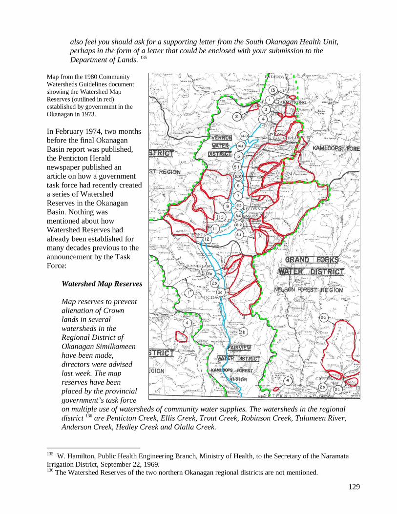
Map from the 1980 Community Watersheds Guidelines document showing the Watershed Map Reserves (outlined in red) established by government in the Okanagan in 1973. In February 1974, two months before the final Okanagan Basin report was published, the Penticton Herald newspaper published an article on how a government task force had recently created a series of Watershed Reserves in the Okanagan Basin. Nothing was mentioned about how Watershed Reserves had already been established for many decades previous to the announcement by the Task Force:
Watershed Map Reserves Map reserves to prevent alienation of Crown lands in several watersheds in the Regional District of Okanagan Similkameen have been made, directors were advised last week. The map reserves have been placed by the provincial government’s task force on multiple use of watersheds of community water supplies. The watersheds in the regional district 136 are Penticton Creek, Ellis Creek, Trout Creek, Robinson Creek, Tulameen River, Anderson Creek, Hedley Creek and Olalla Creek.
135 W. Hamilton, Public Health Engineering Branch, Ministry of Health, to the Secretary of the Naramata Irrigation District, September 22, 1969. 136 The Watershed Reserves of the two northern Okanagan regional districts are not mentioned.
130
Map reserves to prevent the alienation of Crown lands in several watersheds in the Regional District of Okanagan-Similkameen have been made, directors were advised last week. Alderman J.J. Hewitt of Penticton asked if the map reserves meant there would be no more logging in the Penticton Creek watershed. He suggested B.E. Marr, chairman of the task force and acting associate deputy minister of the water resources branch, be asked to notify the regional district of any planned activity in the watershed. 137
Summaries of the powers vested in the Land Act to withhold all dispositions on Crown lands in Watershed Map Reserves, such as timber sales and grazing leases, were completely ignored in the Okanagan Basin final study report, despite the fact that government administrators and bureaucrats, like Ben Marr the co-chair of the Basin study, were intimately cognizant of them, and despite the fact many Reserves had just been established and re-established throughout the Okanagan Basin. In Chapter 11 of the final Okanagan Basin report, Legal, Administrative and Institutional Arrangements, was the following misleading narrative about public rights on Crown lands. The summary failed to make reference to the powerful legacy that Land Act Watershed Reserves had in the Okanagan, and no mention was made of the associated long-held referral system between the Forest Service and the water purveyors when timber sales were issued in the Reserves:
There is also the problem that licencees taking water from a stream have no control over other aspects of watershed management under existing legislation. Logging practices may affect the run-off characteristics of the stream which in turn may affect the adequacy and safety of storage and diversion structures. Erosion may be increased causing turbidity in the water and perhaps necessitate expensive clean-out operations in diversion ponds, or screening, before the water can be used. There are no regulations or requirements by which the B.C. Forest Service has to consult with licencees or to control these effects. Neither has provincial legislation been involved to regulate such land use practices.
Cattle grazing under lease on Crown Land may foul local water supplies, as well as adding nutrients to the tributary systems. Logging practices may increase the contribution of soil and nutrients by reason of erosion and faster spring runoffs. Grazing leases and forestry practices are under the control of the Provincial Forest Service. There are no regulations or requirements that the Forest Service has to consult with water users concerning the management of the watershed area. 138 What actual powers would the government have to enforce proper uses and protection of water supplies? Existing legislation - e.g. Water Rights Act; Pollution Control Acts; Health Act; etc. See Bulletin No. 7, (i.e. local governments or boards have no powers except those given them by or under a provincial statute). 139
The logging and water resource issues that evolved in the 1960s in the Okanagan Basin watersheds, and the attending, consistent angry complaints by irrigation and water purveyors to the provincial government, would play an influential role in the events leading up to the creation of the community watersheds Task Force in 1972, wherein public involvement would play a rather limited role. 137 Penticton Herald article, Watershed Map Reserves, February 25, 1974. 138 Section 11.3.2. 139 Page 202, Appendix C-2, Part II, The “Interest Cards”, Technical Supplement XI.
131
4.3. BC Forest Service Foresters Ordered to Map Register Watershed Reserves
The policy of public ownership of forest lands which has obtained in British Columbia up to the present is wise and should be continued. 140
Registered complaints within community watersheds Task Force correspondence records reveal that a number of Regional Forest Service administrators, particularly those in the Nelson Forest Region, were reluctant, and out-rightly refused, to follow the orders sent to them by the Task Force and the Lands Department Director in 1973 and years following to register the Reserves on their Forest Atlas Reference Maps. Deputy Forest Minister Stokes, the chairman of the provincial Environmental and Land Use Technical Committee set up under the Environmental and Land Use Act was under pressure in 1974 by other Deputy Ministers and the Task Force chairman, and had to personally step in and order his defiant forester troops to register the Watershed Map Reserves on their planning maps, as confirmed in later memos. In early 2005, when the author of this report inspected the Forest Service milar maps, where the Watershed Reserves were featured in blue boundary lines and blue bold lettering, the Forest Service often wrote “Proposed Watershed Reserves.” Yes, the Forest Service registered the Map Reserves as they were ordered to by their commander, Deputy Minister Stokes. However, some foresters kept the upper hand and improperly identified many of them on Forest Atlas Reference Maps: they were not “Proposed” as so written by Forest Service mappers, they had been officially established. And, dispersed amongst these errant entries, some of the maps registered the older community Watershed Reserves with the older Reserve file numbers. Right: Excerpt from a 1977 draft document by the community watersheds Task Force. To avoid public scrutiny, the final 1980 Ministry of Environment document excluded the critical words “watershed map reserves” (see below in section 4.5). 140 C.D. Orchard, Forest Administration in British Columbia, A Brief for the Presentation to the Royal Commission on Forestry, January 1945, page 20.
132
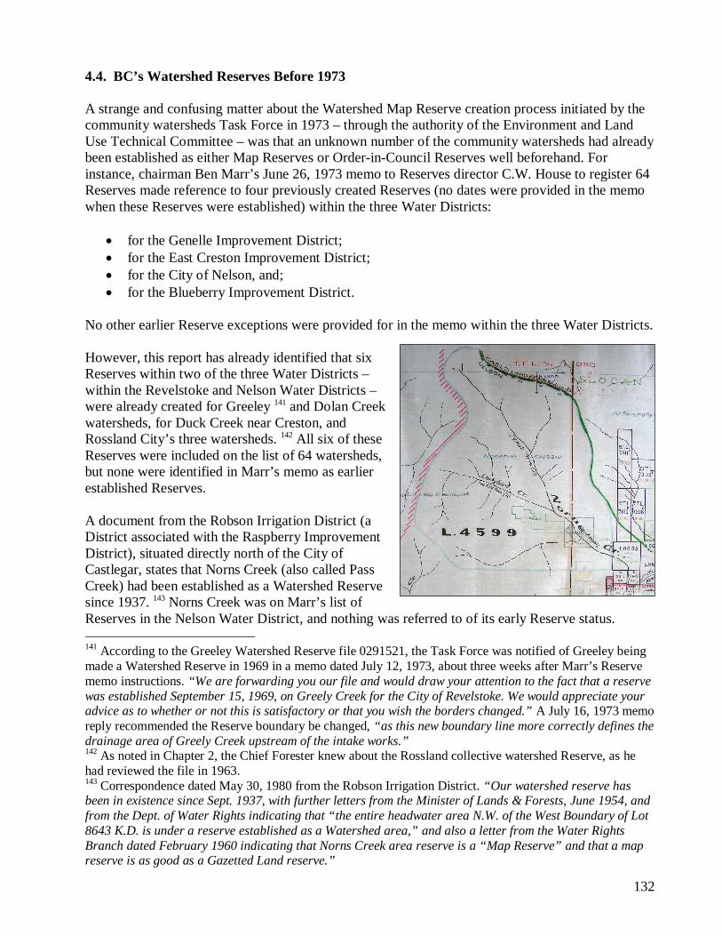
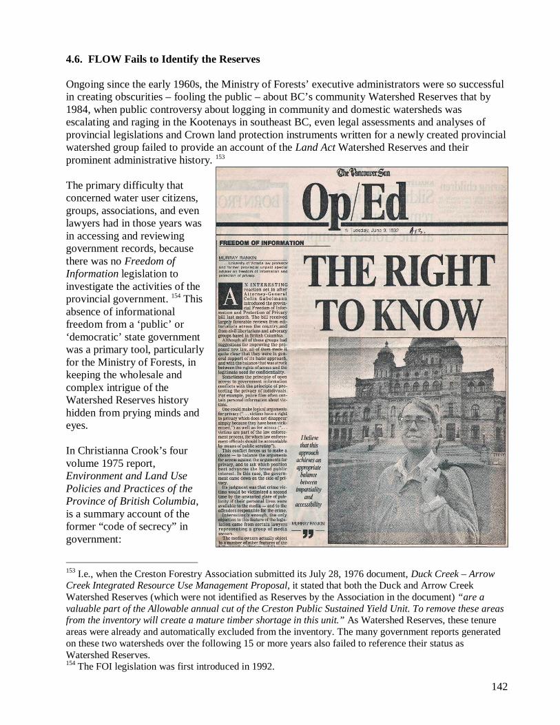
4.4. BC’s Watershed Reserves Before 1973 A strange and confusing matter about the Watershed Map Reserve creation process initiated by the community watersheds Task Force in 1973 – through the authority of the Environment and Land Use Technical Committee – was that an unknown number of the community watersheds had already been established as either Map Reserves or Order-in-Council Reserves well beforehand. For instance, chairman Ben Marr’s June 26, 1973 memo to Reserves director C.W. House to register 64 Reserves made reference to four previously created Reserves (no dates were provided in the memo when these Reserves were established) within the three Water Districts:
for the Genelle Improvement District; for the East Creston Improvement District; for the City of Nelson, and; for the Blueberry Improvement District.
No other earlier Reserve exceptions were provided for in the memo within the three Water Districts. However, this report has already identified that six Reserves within two of the three Water Districts – within the Revelstoke and Nelson Water Districts – were already created for Greeley 141 and Dolan Creek watersheds, for Duck Creek near Creston, and Rossland City’s three watersheds. 142 All six of these Reserves were included on the list of 64 watersheds, but none were identified in Marr’s memo as earlier established Reserves. A document from the Robson Irrigation District (a District associated with the Raspberry Improvement District), situated directly north of the City of Castlegar, states that Norns Creek (also called Pass Creek) had been established as a Watershed Reserve since 1937. 143 Norns Creek was on Marr’s list of Reserves in the Nelson Water District, and nothing was referred to of its early Reserve status. 141 According to the Greeley Watershed Reserve file 0291521, the Task Force was notified of Greeley being made a Watershed Reserve in 1969 in a memo dated July 12, 1973, about three weeks after Marr’s Reserve memo instructions. “We are forwarding you our file and would draw your attention to the fact that a reserve was established September 15, 1969, on Greely Creek for the City of Revelstoke. We would appreciate your advice as to whether or not this is satisfactory or that you wish the borders changed.” A July 16, 1973 memo reply recommended the Reserve boundary be changed, “as this new boundary line more correctly defines the drainage area of Greely Creek upstream of the intake works.” 142 As noted in Chapter 2, the Chief Forester knew about the Rossland collective watershed Reserve, as he had reviewed the file in 1963. 143 Correspondence dated May 30, 1980 from the Robson Irrigation District. “Our watershed reserve has been in existence since Sept. 1937, with further letters from the Minister of Lands & Forests, June 1954, and from the Dept. of Water Rights indicating that “the entire headwater area N.W. of the West Boundary of Lot 8643 K.D. is under a reserve established as a Watershed area,” and also a letter from the Water Rights Branch dated February 1960 indicating that Norns Creek area reserve is a “Map Reserve” and that a map reserve is as good as a Gazetted Land reserve.”
133
Chapter 2.3 of this report makes reference to a list of 14 Watershed Reserves sent to the Gordon Sloan Forestry Commission in late 1944. Some of those Reserves, such as Quartz Creek for the town of Ymir, Smoky Creek for the South Slocan Improvement District, and Brouse Creek for the Nakusp Improvement District, were on Marr’s June 26, 1973 Map Reserve list, but were not mentioned as earlier Reserves. There was another early Reserve called the “West Arm Watershed,” which covered 49,000 acres, over the northern watershed lands of the West Arm of Kootenay Lake, wherein were three separate community Watershed Reserves. Another older Reserve in the Nelson Water District was Narrows Creek, located immediately west of another Creek the Task Force reserved, Proctor Creek (Narrows Creek never made the Task Force’s final 1980 list of Reserves). The other older Departmental Reserves referenced in the list sent to the Sloan Commission by the Forest Service were also re-reserved by the Task Force in other provincial Water Districts. Similarly, Marr’s August 20, 1973 memo to C.W. House to establish 60 Map Reserves in the New Westminster and Vancouver Water Districts also referenced earlier Reserves placed over the towns of Pemberton and Yarrow’s water supplies, and to a Reserve by North Vancouver. A number of these 60 Reserves had already been made Reserves prior to 1973. Marr’s, or the Task Force’s, omissions of the earlier Reserves stated here not only raise critical questions and serious doubts about the administration over community Watershed Reserves and their file history, but also about the ability of the Task Force to have thoroughly assessed government records. It is possible that the community Watershed Reserve files, and their central registry list, were not made accessible to, or were even withheld from, interdepartmental staff or the Lands Department itself. Perhaps, when some of the Reserves were established following requests from provincial water purveyors, the Reserve files were separately held or administered with the Forest Service branch and never forwarded to the Lands Department, contrary to the proper administrative procedures. Whatever the case may have been, the Watershed Reserves were evidently in a messy, uncoordinated and mismanaged state. A similar state of affairs occurred twenty-four years later in about June 1997 when the Slocan Valley-based Valhalla Wilderness Society filed a writ of Petition to the Nelson City Supreme Court concerning two community Watershed Reserves, Mountain Chief and Bartlett Creeks, located northeast of the Village of Silverton on Slocan Lake. In interviews with government staff in late 1997, Ministry of Environment Regional Water Planner Rob McArthur (who had filed a Court Affidavit), described to this report’s author how the BC Surveyor General was unable to locate his own Reserve files on the two watersheds for the BC Attorney General that were supposedly kept in his Reserve file cabinets, in how staff went on a long and frustrating goose chase adventure to locate the missing files. Staff eventually found the two missing files under the isolated custody of the Ministry of Forests, amongst an unknown number of other missing community Watershed Reserve files, files that were meant to be kept under the domain and authority of the Surveyor General. 144 One of the Reserves on the Task Force’s June 26, 1973 list of 64 watersheds included the Village of Silverton’s Bartlett Creek. Lands Department records show that the Bartlett Reserve was established at that time. Older Forest Atlas Reference maps show that Bartlett had been established as a Reserve in the 1950s. 144 From information on this file history, a note stated that the Bartlett Reserve file was sent to “forestry” on December 28, 1990.
134
Old Forest Atlas Map showing the Bartlett Creek Reserve. During the court case Hearing in June 1997, the BC Attorney General’s appointed laywer stated before Supreme Court Justice Paris that the Bartlett Reserve had never been created, and was merely intended to become a Watershed Reserve. An anonymous source in government stated in 1997 that the government had shredded critical documents in the Bartlett Reserve file which registered the Reserve’s creation. As described at length in chapter nine of Will Koop’s 2006 publication, From Wisdom to Tyranny, the Valhalla Wilderness Society had almost opened Pandora’s Box (the hornet’s nest) when it launched the first court case on BC’s community Watershed Reserves, a crisis diffused by the Ministry of Forests through the BC Attorney General when Cariboo MLA David Zirnhelt was Forests Minister. Justice Paris ruled in favour of the Ministry of Forests and Slocan Forest Products, whereby the Ministry of Forests prevented the Valhalla Wilderness Society from stopping logging in a legislated Reserve, and from preventing a legal precedent from cracking open the Ministry’s sordid administrative history of BC’s Watershed Reserves. Immediately after the court case, the Lands Ministry was ordered to remove the Bartlett Reserve from future government Reference planning maps, and then also deleted the Bartlett Reserve from the list of community Watershed Reserve tenures where it had been officially tabulated as a Map Reserve on computer records. 145 The computer data list, which registered the Bartlett and Mountain Chief Creeks as active Watershed Reserve tenures, was never revealed to the Supreme Court before their digital elimination, as apparently that data information was never entered as evidence. 145 Following the court case, the B.C. Tap Water Alliance was provided with a copy of the entire computer list of Watershed Reserves in late 1997. Bartlett was not on this list. The question: who erased the Bartlett Reserve file information from the government’s central computer files?
135
4.5. Le Deception a le Blue Book
Data were prepared and requests made to the Lands Service to establish map reserves for all community watersheds in the Province and to provide status mapping of selected watershed areas. 146
In June 1977, the Water Investigations Branch printed dozens of copies of the community watersheds Task Force’s first draft Guidelines document for BC’s community Watershed Reserves, a draft subsequently revised over a period of three years until it was released to the public in October, 1980. Government staff nicknamed the final document as “The Blue Book,” referring to the blue color of the document’s jacket. It was officially titled Guidelines for Watershed Management of Crown Lands used as Community Water Supplies. Copies of the June 1977 draft were dispatched to many government agencies for internal review and comment. For the first draft, Water Investigations Branch Research Officer Wallace included the following in his June 5, 1977 five-page introductory memo sent to Water Investigations Branch Director P.M. Brady:
The stated purpose of the subject report is to present information gathered as a result of activities of the Task Force on Multiple Use of Watersheds of Community Water Supplies. The report is in the form of guidelines for the use of personnel involved in decisions regarding resource management activities on Crown Lands within community watersheds. The use of the area of watersheds as a rationale for the imposition of management guidelines should be carefully considered.
The draft document stated the following in the Acknowledgements section of the report:
The Water Investigations Branch of the Ministry of the Environment wishes to acknowledge the input by the Land Management Branch for placing map reserves [bold emphasis] on the community watersheds; for extensive land statusing within the watersheds and for the referral of land use applications to the Water Investigations Branch. Acknowledgement is also made to the Forest Service of the Ministry of Forests for similar services in placing watershed map reserves within Provincial Forests [bold emphasis] and for referral of Timber Sale Applications. The continuous assistance and suggestions of the various Regional Resource Management Committees throughout the Province is also greatfully acknowledged.
146 BC Water Resources Service Annual Report, 1973, page T-115.
136
The words “map reserves” in the quote above, words which occurred at least five times in the June 1977 draft, were later stricken from the final October 1980 report. A comparative analysis of these intriguing and troubling omissions is provided in Table 4.2.
TABLE 4.2 – Comparative Analysis of Omissions: Map Reserves
June 1977 Draft October 1980 Final The Water Investigations Branch of the Ministry of the Environment wishes to acknowledge the input by the Land Management Branch for placing map reserves on the community watersheds; for extensive land statusing within the watersheds and for the referral of land use applications to the Water Investigations Branch. Acknowledgement is also made to the Forest Service of the Ministry of Forests for similar services in placing watershed map reserves within Provincial Forests and for referral of Timber Sale Applications. The continuous assistance and suggestions of the various Regional Resource Management Committees throughout the Province is also gratefully acknowledged.
The Inventory and Engineering Branch of the Ministry of Environment wishes to acknowledge the input by the Ministry of Lands, Parks and Housing for extensive land statusing within the watersheds and for initiating a referral system of land use applications within community watersheds to the Inventory and Engineering Branch. Acknowledgement is also made to the Forest Service of the Ministry of Forests for similar services in recording watershed areas within Provincial Forests as map notations of interest and for referral of Timber Sale Applications. The continuous assistance and suggestions of the various Regional Resource Management Committees throughout the Province is also gratefully acknowledged.
In most such cases, it is highly practical for individual water users, because of the small volumes involved, to adopt methods of abstraction offering good protection. However, upon request where there is a group of individual users utilizing a common watershed, the stream has been designated a community watershed for map reserve purposes.
In most such cases, it is highly practical for individual water users, because of the small volumes involved, to adopt methods of abstraction offering good protection. However, upon request, where there is a group of individual users utilizing a common watershed, the stream has been designated a community watershed for the purposes of these Guidelines.
To assist in evaluating the extent of the problem and the feasibility of coming to grips with it, the assistance of both the Land Service and Forest Service was solicited by the Task Force. Initially, the Water Investigations Branch requested the Lands Service to place map reserves on all watersheds in the Province, as shown on the maps in the Appendices. As a result of the map reserves, the Land Service and the Forest Service refer to the study group all applications for land or forest uses within a community watershed. Specifically, when any application for land within a map reserve was submitted to the Lands Service for any use whatsoever, the matter was referred to the Water Investigations Branch for information, comment and recommendations. In this way, cognizance is taken of the water supply function of these lands. Typical referrals covered a wide diversification of activities such as
To assist in evaluating the extent of the problem and the feasibility of coming to grips with it, two courses of action were followed. Firstly, to obtain input from water users, questionnaires were circulated seeking detailed information on the water systems, the watersheds and existing activities and problems within watersheds. Close to a one hundred percent response was obtained to the 325 questionnaires sent out. Secondly, the assistance of both the Ministry of Lands, Parks and Housing and Ministry of Forests was solicited by the Task Force. Initially, the Inventory and Engineering Branch requested the Ministry of Lands, Parks and Housing to place map notation of interests on certain community watersheds in the Province, as shown on the maps in the Appendices. As a result the Ministry of Lands, Parks and Housing and the Forest Service refer to the study group, or the appropriate Regional Water Management Branch, pertinent applications for land or forest uses within a community watershed. Specifically, when any pertinent application for land was submitted to the Ministry of Lands, Parks and Housing, the matter was referred to the Inventory and Engineering Branch for information, comment and recommendations. In this way, cognizance is taken of the water supply function of these lands. Typical referrals covered a wide diversification of activities such as agriculture, grazing, recreation, trapping, shooting,
137
June 1977 Draft October 1980 Final agriculture, grazing, homesteading, recreation, trapping, shooting, residential, industrial, logging, power line and highway right-of-ways, etc. Also, the Forest Service undertook to refer applications for Timber Sales or Harvesting Licences within watershed areas. Again such referrals were for information, comment and recommendations before approval by the Forest Service.
residential, industrial, logging, power line and highway right-of-ways, etc. Also, the Forest Service undertook to refer applications for Timber Sales or Harvesting Licences within watershed areas. Again such referrals were for information, comment and recommendations before approval by the Forest Service.
The “extensive land statusing” by the Ministry of Lands, referred to in the Acknowledgements section in the first entry row in Table 4.2, was the creation and re-creation of Watershed Reserves from 1973 following, Reserves which the Ministry of Forests stated were incorporated within Provincial Forests as “map notations of interest.” 147 The fuzzy terms and vocabulary in the final October 1980 Blue Book document version purposely replaced and omitted the words “Map Reserves” in order to avoid unwanted public attention and curiosity about the Ministry of Forests’ shady history and improprieties, and to obfuscate the recent creation of a host of Watershed Reserves. The Task Force file records failed to indicate the date of when the revisions occurred, who was responsible for removing the references to Map Reserves, and why the omissions occurred in the final revisions. The misdirection, deception and fraud resulting from the revisionary process by unknown parties who specifically removed references to the Watershed Reserves in the community watershed Guidelines document (the Blue Book) would intentionally create enormous confusion to both BC’s water purveyors and to government administrators following late 1980. I.e., the following correspondence from the South Pender Harbour Waterworks District to the Ministry of Lands in 1984, with the irony that the Waterworks District’s community watersheds over Haslam and Silversands Creeks had already been provided with a joint Watershed Map Reserve tenure in 1973:
147 A September 24, 1973 Forest Service Management Victoria headquarters Division memo to the chairman of the community watersheds Task Force stated the following: “This office has received several requests for map reserves forwarded to us from the Department of Lands for watershed purposes. Prior to establishing these map notations within [Provincial] forest reserves [underline emphasis] could you elucidate just what rights are required to be reserved?”
138
There appears to be no legal registration of our watershed other than a listing in Appendix G of the “Guidelines for Watershed Management of Crown Lands used as Community Water Supplies”, dated October 1980. Watershed no 6B, page 23, Haslam Creek, is our only source serving presently some 700 connections. The area is about 11 square miles and includes the Harris Lake drainage area which is also part of our system. 148 Without a legal description and a watershed reserve established, other agencies could claim to be unaware of the existence of the watershed and have no legal requirement to consider the affect of their plans or to advise the South Pender Harbour Waterworks District of such plans. We presently have no authority to control any activity within our watershed, such as logging, camping, spraying, etc. Further, there does not seem to be any requirement that we be advised in advance with respect to any proposed activity within the watershed, either by the public, Government Ministries or B.C. Hydro. Just recently we investigated the plans of the Forest Service in the watershed and found that some logging plans would have had very adverse affects on Haslam Creek water quality. By personal contact and site visits we hope the problems will be overcome but they apparently have neither any obligation to advise us of such plans, nor did they. The same situation occurs in respect to herbicide spraying by either the Forest Service or B.C. Hydro. The only advice required seems to be a legal notice published in a local paper, the descriptions of areas involved are usually less than specific, this means we have to search the papers regularly for possible problems. The Dept. of Health makes regular coliform tests of our water but is not obligated to test for residual herbicide sprays and in any case it would be detected after the fact, not very reassuring to the consumers. We need prior advice. It has become increasingly apparent that we need additional protection against abuses of the watershed which would affect the water quality for some 2,000 users. In referring to page 8 of the “Guidelines”, it specifically states, underlined, “In law, the onus to deliver high quality water to the consumer rests with the water purveyor.” In light of the above facts we request that the ministry establish a Watershed Reserve or some similar legal tenure for the above watershed at the earliest possible date. 149
148 The Task Force should have divided the McNeill Lake / Haslem Creek Map Reserve into two Reserves, instead of one, created over two separate watersheds, Haslem Creek and Silversands Creek. By creating a single reserve, it changed the status of the reserve to a Category 2, for Reserves over 6 square miles. Had the Reserve been divided in two, they each would have fallen under the Category 1 Reserve, for areas under 6 square miles, and been afforded a separate and more powerful protection ranking imposed by the Task Force in their final Blue Book Guidelines report. 149 South Pender Harbour Waterworks District Chairman David H. Maw to Ministry of Lands, Parks and Housing, June 1, 1984. Note: the order of the paragraphs in the original letter has been rearranged here to better focus the theme and arguments.
139
A year and a half before the October 1980 Guidelines document was published, the Township of Spallumcheen, located north of Vernon City, wrote a series of letters over a period of almost 12 months to government administrators about legislative protection of their drinking water sources. In a February 6, 1979 letter to Deputy Forests Minister Mike Apsey, the former executive of the Council of Forest Industries (to which he would soon return as its president!), were questions about Watershed Map Reserves.
Please be advised your letter of January 25th, 1979 was dealt with by Council at a regular meeting of Feb. 5th, 1979. A motion was passed that a letter be sent advising that the reply received was not deemed satisfactory insofar as protection to the Water Shed is concerned. The Municipal Council is of firm opinion that all domestic Water Sheds should be given the ultimate in protection from developments, particularly in the Okanagan area where water is a scarce resource. It is felt that the safeguards outlined do not provide adequate security for the Waterworks District involved. Council is under the impression that neither the Health Unit nor the Pollution Control Branch have any jurisdiction over Crown lands. Council also expressed a wish that your procedure be amended so that relevant authorities in affected areas be allowed to make comments directly to the decision making body. In this case, that would mean Stepney Waterworks District as well as the Township of Spallumcheen. It would further imply that such representations could be made in person to the actual decision making body, in addition to whatever written documentation is considered pertinent. A further question comes to mind, in that your letter referred to “water shed reserves” are noted on legal survey maps and on Forest Service Atlas Maps. It is not clear who decides what a Water Shed Reserve is. It would be appreciated if you could expand on this comment and advise if indeed the Water Rights Branch has taken steps to determine the catchment area and head waters area for such Waterworks systems as Glanzier Creek and Stepney Waterworks District.
Perhaps the Township’s ongoing questions inevitably helped prompt Apsey’s Ministry of Forests’ staff to tidy up and revise the Blue Book Guidelines document in 1980. Deputy Minister Apsey replied to the Township of Spallumcheen’s concerns on March 26, 1979, and recommended that the Township contact J.D. Watts, the chairman of the community watersheds Task Force “if you wish any further information on watershed reserves.” However, Apsey failed to provide any substantive policy and legislative information about Watershed Reserves to the Township, and incorrectly inferred that the community watersheds, which had all been tenured as Map Reserves under the Land Act, were “subject to multiple use.”
I acknowledge your letter of February 8, 1979 in which you express the concern of your Council about the protection measures given to domestic watersheds.
140
In 1972 a Provincial government Task Force was formed to investigate the practicality 150 of obtaining a wholesome water supply from streams, the watersheds of which are subject to multiple use, and to recommend policy and procedures for the management of land use conflicts within watersheds. As a result of their investigations a set to proposed guidelines has been prepared for the management of Crown land within community water supply watersheds. The proposed guidelines are intended for use by various Crown agencies responsible for resource use, construction or development on Crown lands within watersheds. As a water user you would have been contacted by the task force on Multiple Use of Watersheds of Community Water Supplies and I must assume that you are fully aware of the proposals. Watershed reserves are established through the Water Investigations Branch of the Ministry of Environment. The Land Management Branch of the Ministry of Lands, Parks and Housing and in the case of provincial forests, the Forest Service place community watershed map reserves on their ministry reference maps for inter-ministerial referral and consultative purposes.
Following a subsequent series of letters between the Township of Spallumcheen and the government, on December 7, 1979 the Township wrote the following to Minister of Forests Tom Waterland:
For many years the Township of Spallumcheen, and as well the city of Armstrong, have been concerned about the quality and quantity of the water resource which services these Municipalities. The source of course is Crown land to the East of Spallumcheen boundaries. At the Council meeting of December 3rd, 1979, a motion was passed to request some form of tenure or reserve over these lands. The motion designated the areas which serve as Watersheds, Head Waters or catchment Areas for the supply of domestic water in Spallumcheen. The Municipality, therefore, would like a statement from your Ministry as to the possibility of being granted some form of tenure, whether it would be by reserve, permit, tree farm 151 or outright purchase. An identical letter is being written to the Minister of Lands, Parks & Housing, the Honourable James Chabot and the Minister of the Environment, the Honourable C.S. Rogers. The same question is being put to all three Ministers, in the hope that some positive program could be established which would once and for all give the citizens of these communities peace of mind regarding their water resource. Your assistance is sincerely appreciated.
Evidently, the Social Credit government was reluctant to properly inform the Township of what its rights were, or what the Land Act powers were with respect to Map Reserves or Order-in-Council
150 Apsey was incorrect here. The actual term used in the Task Force Terms of Reference states “practicability” (i.e., feasibility), not “practicality.” The definitions for each are distinctly different. 151 It is odd that the Township would have requested a Tree Farm. A likely explanation to this confusion is that the Greater Vancouver Water District had agreed to a quasi-Tree Farm License over its three watersheds in 1967, and that the Township inadvertently and incorrectly thought this was a form of tenured protection.
141
Reserves, which had been carefully set out in Lands Ministry policy manuals. 152 On January 8, 1980, some ten months before the Guidelines document was forwarded to provincial water purveyors, Forests Minister Tom Waterland wrote the following to the Township of Spallumcheen:
As you are no doubt aware, watershed considerations affect a large proportion of our forest land so that it would not be possible, in most cases, to create outright watershed reserves without a drastic reduction in the level of harvesting [bold emphasis]. It was mentioned to you, in our letter of March 26, 1979, that the government has adopted a policy of integrated resource use in watersheds, with emphasis on protection of water quality and quantity. Further mention was made that watershed reserves are established through the Water Investigations Branch of the Ministry of Environment. The Land Management Branch, Ministry of Lands, Parks and Housing and, in the case of Provincial Forests, the Forest Service place community watershed map notations on their ministerial reference maps for inter-ministerial referral and consultation purposes.
Above: Section of a map from the 1980 Blue Book Guidelines document showing the community Watershed Map Reserves. Those outlined in red are: 1, Fortune Creek (Armstrong City, and 6 other users); 2, Irish/Coyote Creek (Grandview Improvement District); 3, Huntley Creek (Larkin Improvement District; 4, BX Creek (Vernon City); 13, Glanzier Creek (Stepney Improvement District). However, contrary to what Minister Waterland stated to the Township, the government had already created Watershed Map Reserves, and did so for a number of watersheds near the Township of Spallumcheen, where, according to his letter, the lands had been protected from dispositions, such as logging through Timber Sale permit tenures. And, when the Township received its copy of the Ministry of Environment’s October 1980 Guidelines document, nowhere did it describe that Watershed Map Reserves were created, or re-created, for the Township’s, and BC’s, watersheds that were identified in the Blue Book document and in its appendices.
152 See Appendix A, on the history of Reserve legislations and manuals.
142
4.6. FLOW Fails to Identify the Reserves Ongoing since the early 1960s, the Ministry of Forests’ executive administrators were so successful in creating obscurities – fooling the public – about BC’s community Watershed Reserves that by 1984, when public controversy about logging in community and domestic watersheds was escalating and raging in the Kootenays in southeast BC, even legal assessments and analyses of provincial legislations and Crown land protection instruments written for a newly created provincial watershed group failed to provide an account of the Land Act Watershed Reserves and their prominent administrative history. 153 The primary difficulty that concerned water user citizens, groups, associations, and even lawyers had in those years was in accessing and reviewing government records, because there was no Freedom of Information legislation to investigate the activities of the provincial government. 154 This absence of informational freedom from a ‘public’ or ‘democratic’ state government was a primary tool, particularly for the Ministry of Forests, in keeping the wholesale and complex intrigue of the Watershed Reserves history hidden from prying minds and eyes. In Christianna Crook’s four volume 1975 report, Environment and Land Use Policies and Practices of the Province of British Columbia, is a summary account of the former “code of secrecy” in government:
153 I.e., when the Creston Forestry Association submitted its July 28, 1976 document, Duck Creek – Arrow Creek Integrated Resource Use Management Proposal, it stated that both the Duck and Arrow Creek Watershed Reserves (which were not identified as Reserves by the Association in the document) “are a valuable part of the Allowable annual cut of the Creston Public Sustained Yield Unit. To remove these areas from the inventory will create a mature timber shortage in this unit.” As Watershed Reserves, these tenure areas were already and automatically excluded from the inventory. The many government reports generated on these two watersheds over the following 15 or more years also failed to reference their status as Watershed Reserves. 154 The FOI legislation was first introduced in 1992.
143
In general, there are relatively few government publications which illuminate the kinds of issues which are identified as specific objectives in Section 1.2. It is not usual for governments to publicize in clear, concise and comprehensible fashion such issues as policy, objectives, strategies, procedures, conflicts, laws, etc., although much of this information is undoubtedly stored in internal files which are largely confidential and inaccessible. Confidentiality is a code of government business conduct, and is usually justified on the grounds that release of information would provide an unfair advantage to certain segments of the public and, therefore, would not be in the general public interest. There is an oath of discretion on such matters which must be sworn by all permanent public servants. Of course, the code of secrecy has also been employed as a convenient tool in cases where there is fear of public reaction, and it now constitutes such an entrenched working policy in most government agencies that many of its applications are unnecessary and/or against the public interest. 155
The Slocan Valley Watershed Alliance was formed in late 1981 and evolved to represent ten communities and two Villages. In late February 1981, thirteen watershed and outdoor groups from the southern Interior and southeast BC met in South Slocan City to voice their concerns about logging in community watersheds. On March 4, 1981, the Nelson Daily News newspaper reported the following list of participants:
The Mark Creek Public Advisory Group from the Kimberley Skookumchuk area; the South Okanagan Environmental Coalition; South Slocan Water Users Committee; Beasley water users; Kootenay Mountain Club; the Big Ben Resource Council from Golden; the Nelson Conservation Centre; Perry Ridge Water Committee; Creston Public Advisory Committee; Argenta Resource Group; the Hamill-Clute Folio Committee from the Argenta area; the Ezra Creek Water Improvement District from Thrums; the Taghum Watershed Committee; the Genelle Water Improvement District; and the Nelson Watershed Committee.
After years of intensive battling with the Ministry of Forests, the Slocan Valley Watershed Alliance eventually hosted a provincial “citizens conference” in the small Town of Winlaw on August 4-5, 1984. It was appropriately called FLOW ( For the Love Of Water). A July 13, 1984 information article said the conference will:
bring together water users throughout the Province to develop and lobby for a fair, objective water policy and watershed management process for B.C. Participants will review the technical, legal and political realities of water management. All point to one central problem, the alliance says: “B.C. has no provincial water policy or provincial watershed management process.”
155 Volume One, pages 8-9.
144
For the conference:
Nelson City lawyer Donald Skogstad prepared a confidential ten-page legal assessment and a four-page presentation called Notes on Legal Aspects of Domestic Water Use, and;
Vancouver lawyer Gerry Thorne prepared a thirty-page address, Notes for an Address to the Slocan Valley Watershed Association Conference, which reviewed federal and provincial legislation and laws on resource use.
However, both presenters and their conference presentation documents failed to identify the Land Act administrative instruments and provisions for Crown land Order-in-Council and Map Reserves for community watersheds, identified in provincial Statutes at that time, respectively, as Section 11 and Section 12 Reserves. 156 References were made in the lawyers’ presentation assessments to Ecological Reserves, but nothing was explained about how the same Land Act legislation allowed for their creation, as the Land Act shares the identical provisions in creating almost absolute Crown land protections for both Ecological Reserves and community Watershed Reserves. 156 Section 11 and Section 12 Reserves as identified in the 1970 revised Land Act, were later renamed, respectively, as Section 15 and Section 16 Reserves in the revised 1996 Land Act. See Appendix A.
145
It is ironic that the Watershed Reserves went unidentified by the newly created BC Watershed Protection Alliance, because the West Kootenays, where the inaugural conference was held, was in fact surrounded by Watershed Reserves (see map - the green dot shows conference location). Had the many members of the B.C. Watershed Protection Alliance been properly briefed and grounded about the Reserves, the actions of the Alliance may have significantly influenced, revised and shifted community watershed history in British Columbia from the way we know it today.
The Big Eddy Waterworks District became an enthusiastic member of the BC Watershed Protection Alliance following its formation on October 1, 1984. Membership on the Alliance included the following:
Argenta Folio Committee; Arrowsmith Ecological Association; ASPECT; Barbizon Magazine; Big Bend Resource Council; Big Eddy Watershed Committee; Blewett Watershed Committee; Blueberry Creek Irrigation District; Buck Creek Residents Association; Citizens Opposing Dumps; Clearwater Improvement District; Crawford Bay &
146
Area Watershed Committee; Creston Public Advisory Committee; Eastshore Environmental Alliance; Elliott-Anderson Watershed Committee; Elkford, District of; ENGO Standing Committee; Ezra Creek Water Improvement District; Friends of Clayoquot Sound; Friends of the Stikine; Genelle Water Improvement District; the Greater Vancouver Water District; 157 Green Party of B.C.; Gun Lake Ratepayers Association; Hailos Society; Harrop/Procter Water Users; Institute for New Economics; Johnson’s Landing Folio Committee; Kootenay Area Indian Council; Kootenay Land Settlement Society; Kootenay Mountaineering Club; Ladysmith, Town of; Lillooet Tribal Council; Mark Creek Public Advisory Group; Merry Creek/Robson Ridge Water Users; Nechako Neyenkut; Nelson Conservation Society; Nelson Watershed Committee; Nlaka’pamux Nation Tribal Council; Parson Watershed Alliance; People’s Commission; Perry Ridge Water Users Association; Prince George Environmental Protection Society; Red Mountain Residents Association; Residents for a Free Flowing Stikine; Save the Bulkley; Sherraden Creek Water Users Group; Shuswap Nuclear Study/Action Group; Shutty Bench Watershed Committee; Sierra Club of Western Canada; Slocan Valley Watershed Alliance; SNAG; South Okanagan Environmental Coalition; South Slocan Water Users; South Island Tribal Council; Society Promoting Environmental Conservation (SPEC); Sproule Creek Watershed Management Committee; Taghum Watershed Committee; Telkwa Foundation; Trozzo Creek Watershed Committee; Valhalla Wilderness Society; West Coast Environmental Law Association; Western Canada Wilderness Committee; Winlaw Creek Watershed Committee; Yalakom Ecological Society; Yellowhead Ecological Society.
The Alliance was responsible for drumming up much-needed public awareness of issues related to community and domestic watersheds over the following six or so years, causing reverberations across the Province. The continual actions from many of these groups would also force the Ministry of Forests to internally investigate government liability policies over Crown land logging in community watersheds (see Chapter 9, The Looming Issue of Liability). Despite its great influence, the Alliance somehow failed to account for the Watershed Reserves while they were being, or about to be, invaded and compromised, while being underhandedly and secretly included in the Chief Forester’s Annual Allowable Cut and Timber Supply Review determinations. 157 Foresters at the Greater Vancouver Water District joined the Alliance most likely to monitor its proceedings and to report on the matter to outside interested parties. In the late 1990s, the author discovered that the Water District had been a member of the Council of Forest Industries since 1982.