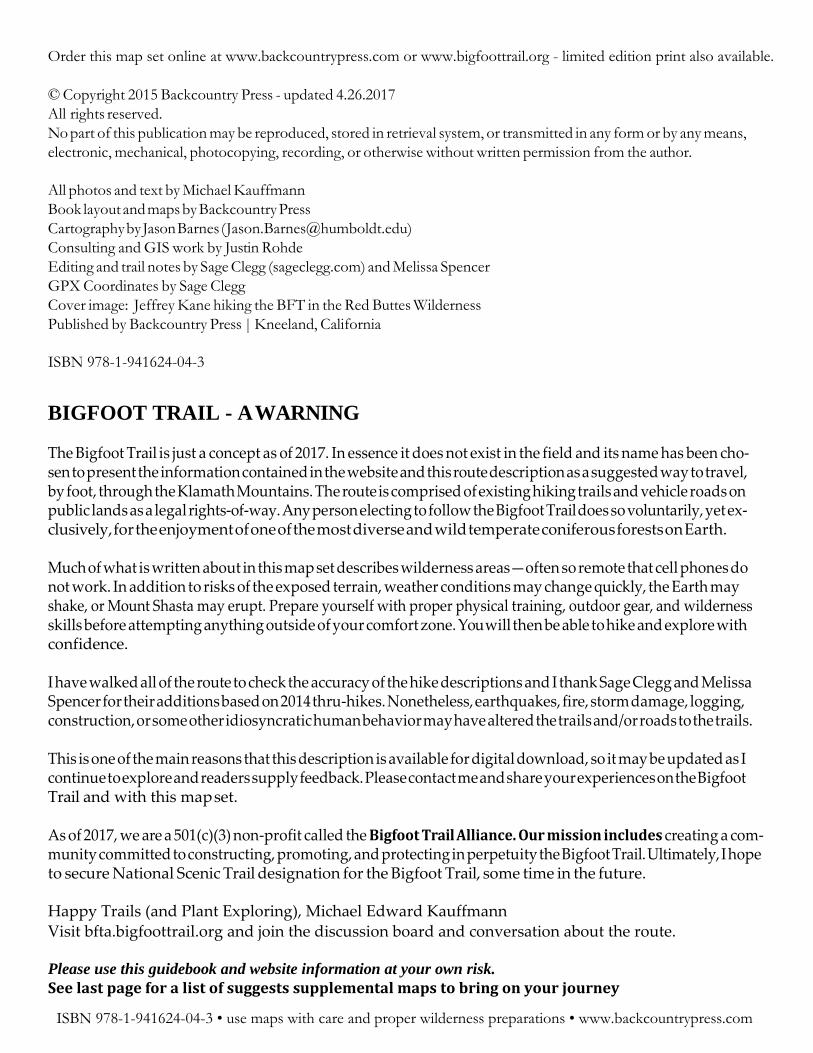
The Bigfoot Trail • V3.2017 Map Set & Trail Description Michael Kauffmann Jason Barnes Bigfoot Trail Explore the biodiversity of the Klamath Mountains 32 conifer species, 360 miles, 6 wilderness areas, and 1 national park BACK COUNTRY PRESS Humboldt Co., CALIFORNIA
Transcript
The Bigfoot Trail • V3.2017 Map Set & Trail Description
Michael Kauffmann Jason Barnes
Bigfoot Trail Explore the biodiversity of the
Klamath Mountains 32 conifer species, 360 miles,
6 wilderness areas, and 1 national park
BACK COUNTRY
PRESS Humboldt Co., CALIFORNIA
Order this map set online at www.backcountrypress.com or www.bigfoottrail.org - limited edition print also available.
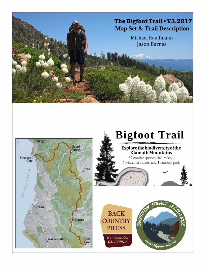
All photos and text by Michael Kauffmann Book layout and maps by Backcountry Press Cartography by Jason Barnes ( [email protected]) Consulting and GIS work by Justin Rohde Editing and trail notes by Sage Clegg (sageclegg.com) and Melissa Spencer GPX Coordinates by Sage Clegg Cover image: Jeffrey Kane hiking the BFT in the Red Buttes Wilderness Published by Backcountry Press | Kneeland, California
ISBN 978-1-941624-04-3
BIGFOOT TRAIL - A WARNING
The Bigfoot Trail is just a concept as of 2017. In essence it does not exist in the field and its name has been cho- sen to present the information contained in the website and this route description as a suggested way to travel, by foot, through the Klamath Mountains. The route is comprised of existing hiking trails and vehicle roads on public lands as a legal rights-of-way. Any person electing to follow the Bigfoot Trail does so voluntarily, yet ex- clusively, for the enjoyment of one of the most diverse and wild temperate coniferous forests on Earth.
Much of what is written about in this map set describes wilderness areas—often so remote that cell phones do not work. In addition to risks of the exposed terrain, weather conditions may change quickly, the Earth may shake, or Mount Shasta may erupt. Prepare yourself with proper physical training, outdoor gear, and wilderness skills before attempting anything outside of your comfort zone. You will then be able to hike and explore with confidence.
I have walked all of the route to check the accuracy of the hike descriptions and I thank Sage Clegg and Melissa Spencer for their additions based on 2014 thru-hikes. Nonetheless, earthquakes, fire, storm damage, logging, construction, or some other idiosyncratic human behavior may have altered the trails and/or roads to the trails.
This is one of the main reasons that this description is available for digital download, so it may be updated as I continue to explore and readers supply feedback. Please contact me and share your experiences on the Bigfoot Trail and with this map set.
As of 2017, we are a 501(c)(3) non-profit called the Bigfoot Trail Alliance. Our mission includes creating a com- munity committed to constructing, promoting, and protecting in perpetuity the Bigfoot Trail. Ultimately, I hope to secure National Scenic Trail designation for the Bigfoot Trail, some time in the future.
Happy Trails (and Plant Exploring), Michael Edward Kauffmann Visit bfta.bigfoottrail.org and join the discussion board and conversation about the route.
Please use this guidebook and website information at your own risk. See last page for a list of suggests supplemental maps to bring on your journey
ISBN 978-1-941624-04-3 • use maps with care and proper wilderness preparations • www.backcountrypress.com
y high school biology teacher inspired my love for natural history. After hiking the Continental Divide Trail, I fell in love with long-distance hiking. The Bigfoot Trail combines the two.
Eminent botanist John O. Sawyer and I once discussed the lack of connectivity between the wilderness areas in the Klamath Mountains. This led us to pour over maps, talk rare plants, and plan a path that would connect these wild places. In 2009, I first walked this route and over the past few years have re-hiked various pieces to “finalize” the trek I call the Bigfoot Trail. This project combines long-distance hiking and natural history by defining a thru-hike in one of the most species-rich temperate coniferous forest on Earth. In my time living in northwest California, I have fallen deeply in love with the uniqueness of the Klamath Mountains. So much so that I wrote a natural history and hiking guide called Conifer Country which documents and celebrates the region. While writing that book, I hiked thousands of miles in search of wild trees. The Bigfoot Trail also grew out of that experience. The trail begins on the subalpine slopes of the Yolla Bolly-Middle Eel Wilderness, traverses the Klamath’s most spectacu- lar peaks, crosses all its wild rivers, and ends at the edge of the continent in the temperate rainforest. It highlights all that Conifer Country has to offer. I believe that by establishing this route a deeper understanding and awareness will be fostered for this region. This trail, and organization, is about the other biota who live in the Klamath Mountains—ultimately to function as stewards for their protection.
About the exceptional regional conifer diversity omplex interactions between biotic and abiotic factors have encouraged and nurtured biodiversity in the Klamath Mountains over millions of years. The region is a botanical museum, hiding relicts of epochs gone by called paleo-
endemics and also a cradle, promoting the adaptive evolution of new species called neoendemics. Complex climate and soils nurture microsites which, in essence, incubate biodiversity. The area also has a central location and continuity with other mountain ranges along the Pacific Slope. Across this landscape, a mosaic of habitats mix at a crossroads of five biotic regions—the Cascades, Coast Range, Great Basin, Central Valley, and Sierra Nevada—each helping to define the Klam- ath Mountains. Within the geologic boundaries defining these complex habitat mosaics, there are 3,540 taxa (species, subspecies, and varieties) of vascular plants and up to 38 species of conifers, depending on how one delineates the region (Sawyer 2006). In addition to plants, the region holds exceptional diversity in amphibians, mammals, and birds. I think the conifers represent a manageable means to begin to comprehend all biodiversity in the region. In the Tertiary, beginning around 65 million years ago [Ma], a temperate forest prevailed unlike any other in Earth’s his- tory. Referred to as the Arcto-Tertiary forest—existing on a landmass that would soon become North America, Europe, and Asia—a blending of conifers and broad-leaved trees dominated the landscape. With continental drift and climate change, the offspring of these great forests were fragmented. Over time, ice ages came and went, causing a change in flora as increasingly dry conditions became more common. The descendents of the Arcto-Tertiary forest became less extensive and more isolated. These progenitors remained, finding refuge in the higher and cooler regions which maintained a cli- mate more similar to that of the early Tertiary—in what we now call northwest California and southwest Oregon. Here today we glimpse a forest that is similar to the forests of 65 Ma. Holdouts include, but are not limited to, Brewer spruce, Port Orford-cedar, redwood, California pitcher plant (Darlingtonia calfornica), and Kalmiopsis leachiana (a shrub that lacks a common name, probably due to its rarity). North America holds two of the most species-rich temperate forests in the world: those of the southern Appalachian and Klamath Mountains. What do these locations have in common? Glaciers and seas did not completely cover them during the Cenozoic and the mountains were monadnocks, or islands above the plains, offering temperate refuges to plants and animals over time. Both locations have historically maintained a moderated climate. These areas are beyond the southern terminus of the enormous continental ice sheets of the Pleistocene. Some plants undoubtedly remained in these regions through historic climatic change, while other species repeatedly moved in as climate cooled and glaciers pushed southward and then moved out following glaciers northward. These dynamic fluctuations have cradled plant diversity in these two unique regions. The current consequences of these historical patterns are that the Klamaths and southern Appalachians have grand floristic diversity, a concentration of endemic plants, and a fundamental importance to the forest floras of nearby regions (Whittaker 1964). Per unit area, the Klamath Mountains and the southern Appalachian Mountains hold more plant taxa than any others in North America. Plant genera such as Cornus (dogwoods), Asarum (wild ginger), and various co- nifers (Pinus, Abies, Thuja, Chamaecyparis) grow a continent apart while providing a comparative glimpse of an ancient flora.
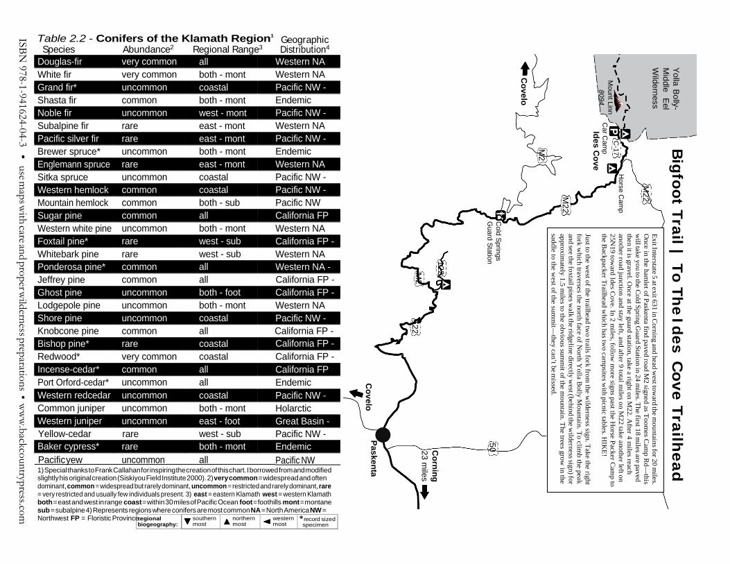
Table 2.2 - Conifers of the Klamath Region1
Species Abundance2 Regional Range3 Geographic Distribution4
Douglas-fir very common all Western NA White fir very common both - mont Western NA Grand fir* uncommon coastal Pacific NW - Shasta fir common both - mont Endemic Noble fir uncommon west - mont Pacific NW - Subalpine fir rare east - mont Western NA Pacific silver fir rare east - mont Pacific NW - Brewer spruce* uncommon both - mont Endemic Englemann spruce rare east - mont Western NA Sitka spruce uncommon coastal Pacific NW - Western hemlock common coastal Pacific NW - Mountain hemlock common both - sub Pacific NW Sugar pine common all California FP Western white pine uncommon both - mont Western NA Foxtail pine* rare west - sub California FP - Whitebark pine rare west - sub Western NA Ponderosa pine* common all Western NA - Jeffrey pine common all California FP - Ghost pine uncommon both - foot California FP - Lodgepole pine uncommon both - mont Western NA Shore pine uncommon coastal Pacific NW - Knobcone pine common all California FP - Bishop pine* rare coastal California FP - Redwood* very common coastal California FP - Incense-cedar* common all California FP Port Orford-cedar* uncommon all Endemic Western redcedar uncommon coastal Pacific NW - Common juniper uncommon both - mont Holarctic Western juniper uncommon east - foot Great Basin - Yellow-cedar rare west - sub Pacific NW - Baker cypress* rare both - mont Endemic
Pacific yew uncommon all Pacific NW 1) Special thanks to Frank Callahan for inspiring the creation of this chart. I borrowed from and modified slightly his original creation (Siskiyou Field Institute 2000). 2) very common = widespread and often dominant, common = widespread but rarely dominant, uncommon = restricted and rarely dominant, rare = very restricted and usually few individuals present. 3) east = eastern Klamath west = western Klamath both = east and west in range coast = within 30 miles of Pacific Ocean foot = foothills mont = montane sub = subalpine 4) Represents regions where conifers are most common NA = North America NW = Northwest FP = Floristic Province.
Exit Interstate 5 at exit 631 in Corning and head w
est toward the m
ountains for 20 miles.
Once in the ham
let of Paskenta find paved road M2 signed as Toom
es Cam
p Rd—
this w
ill take you to the Cold Spring G
uard Station in 24 miles. The first 18 m
iles are paved then it is gravel. O
nce at the guard station, take a right on M22. A
fter 4 miles reach
another road junction and stay left, and after 9 total miles on M
22 take another left on 25N
19 toward Ides C
ove. In 2 miles, follow
more signs past the H
orse Packer Cam
p to the B
ackpacker Trailhead which has tw
o campsites w
ith picnic tables. HIK
E!
Just to the west of the trailhead tw
o trails fork from the w
ilderness sign. Take the right fork w
hich traverses the north face of North Y
olla Bolly M
ountain. To climb the peak
and see the foxtail pines walk the ridgeline directly w
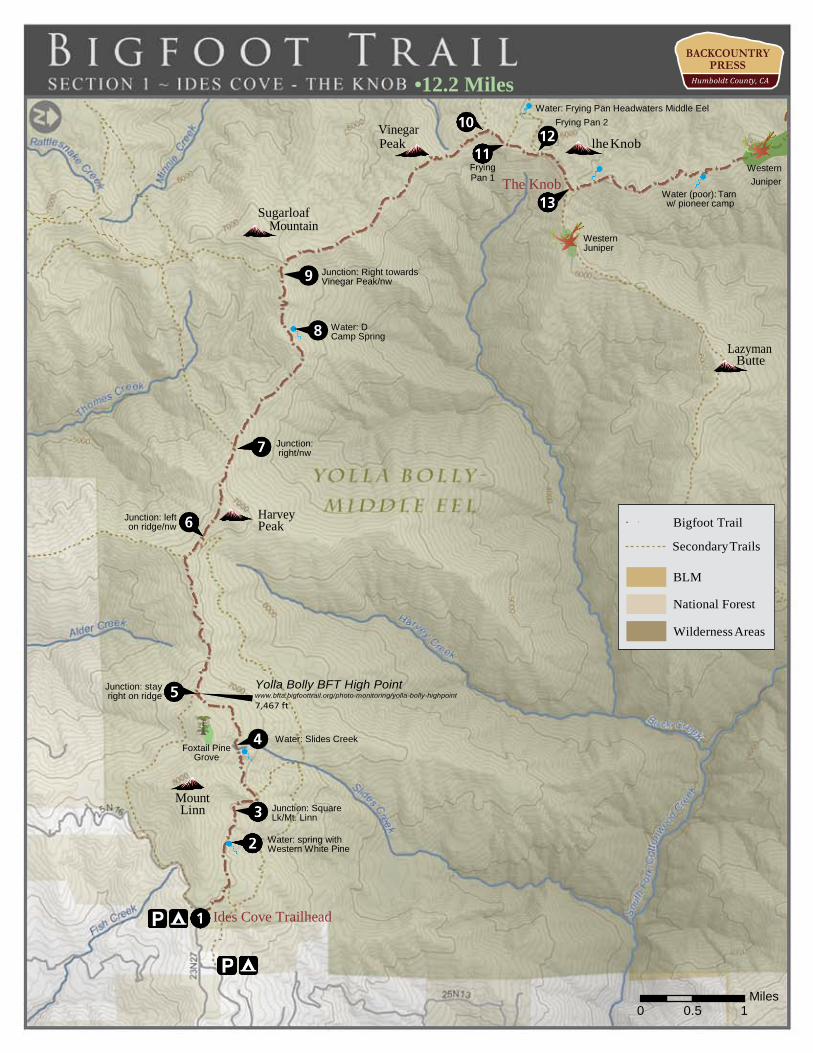
0.0 Trailhead to Ives Cove Loop (0.0) 0.2 Cross a spring with views to Mount Shasta and Mount Lassen. (0.2) 0.4 At an unsigned post and trail junction stay left. (0.2) 0.9 Cross a spring. Just beyond western white pine become common. This species is uncommon
south of the Trinity Alps. (0.5) 1.3 Junction side route to Square Lake. It is possible to climb to Mount Linn from here. (0.4) 1.5 Junction with a trail leading to Cedar Camp and Burnt Camp—stay left. (0.2) 2.0 Pass a meadow and creek below Mount Linn—this is another possible route to the
top of the peak. (0.5) 2.1 Creek and meadow. This is the last water source for 5 miles and the last flowing water for quite a
while—fill up! (0.1) 3.0 After walking through some sublime, Sierra-like Shasta fir forest, meet the junction with the
South Yolla Bolly Trail on a ridgeline with spectacular views. Continue west along the ridgeline into the depths of the wilderness. (0.9)
3.5 Drop to a saddle with beautiful Jeffrey pine forest. This forest type will be the norm for the next 20 or so miles through the wilderness. After the saddle contour across talus—this is also the last of the western white pines for nearly 80 miles. (0.5)
4.6 Reach a junction with Old Thomas Pocket Ridge Trail—stay on the ridge toward Brown’s Camp. (1.1)
4.8 Junction with Ides Cove Loop Trail, again stay straight on the ridge. Ridge walking is also the norm through the entire wilderness. If the trail becomes faint at any time in the next 15 miles, stay on the ridge and the trail should again become evident. There has been a lot of intermittent burn throughout the wilderness since 2007, so some trail has become faint. (0.2)
5.8 Reach the junction with the unsigned Kinglsey Lake Trail, which drops to the left (south), continue along the ridge. (1.0)
7.3 Reach spring at D Camp (low water in dry years). Next water is 5 miles ahead. (1.5) 8.0 Reach another sign and trail junction to Kingsley Lake—continue straight, along
ridgeline, and up. (0.7) 8.2 On a ridgeline just below Sugarloaf Mountain come to a junction with the Summit Trail. From
here cross over the ridge and follow the faint trail—now in a northward direction. (0.2) 8.6 As the ridge and trail drop in elevation the Shasta firs disappear—not to be seen again until the
Trinity Alps—and curl-leaved mountain mahogany becomes common. (0.4) 10.8 After some undulating ridge walking reach a junction with the Windy Ridge Trail, which heads
left (west)—stay straight along the ridge and drop to a saddle. As you descend The Knob is in view. The trail is iffy through here because of burn but the trail will contour to the east of this “knob.” (2.7)
11.1 At the saddle there is another faint junction. The left fork drops to The Fryingpan which offers camping and creek—while this will take you 0.5 miles out of the way the trail will rejoin the route without any backtracking. Continue along the ridge if you do not need water—this trail deterio- rates in a burn area, but just stay on the ridge and you will re-find the trail below The Knob. (0.3)
11.9 Trail junction below The Knob. Left fork drops to The Fryingpan. Stay straight and climb. (0.8) 12.2 After contouring to the east of The Knob on a steep, exposed slope, the trail drops through burn
to a junction with Lazyman Ridge Trail. This trail was dug out nicely by firefighters in 2008 and though it is not a maintained route it looks as one from this junction. Stay left on the more faint trail that heads due North toward North Yolla Bolly Peak. (0.3)
ISBN 978-1-941624-04-3 • use maps with care and proper wilderness preparations • www.backcountrypress.com
Water: North Yolla Bolly Spring Enter the Klamath Mountains
Junction Powell Ridge trail, stay right
Robinson Creek
Intermittent Stream
Devils Creek Spring
Western Juniper, only on the BFT
Tarn w/ pioneer camp
Lazyman Butte
Western Juniper
1he Knob The Knob
Miles 0 0.5 1
● !
Wilderness Areas
Bigfoot Trail
Secondary Trails
National Forest
Section 2 | The Knob to West Low Gap
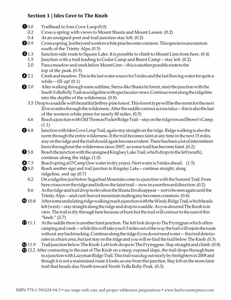
12.2 Lazyman Butte Trail junction (0.0) 12.5 Contour down ridge to a saddle just above a creek canyon. If you descend to the creek there
should be water here in the early season—though you may have to walk down the canyon a bit to find it. Significant burn in the forest make it difficult to follow, stay on ridge. (0.3)
14.2 At a tarn on the ridgeline cross in the middle of the meadow and watch for the trail on the other side, still on the ridge. This area was an old camp in the late 1800’s—probably during the gold rush. I found several old bottles here dating as old as 1886! Though it is faint, the trail can be found. Have confidence though…just walk the ridge if you can’t find it. (1.7)
14.7 Come to a rocky gully on the right of the trail. While climbing, Western junipers are quite common here. This is the only place to find this species along the Bigfoot Trail. (0.5)
15.3 Saddle with big, old western juniper. (0.6) 15.7 Spring (0.4) 15.9 Creek (0.2) 16.3 Reach a ridgeline above an enormous ponderosa pine, then descend (0.4) 16.8 Approaching Robinson Creek crossing, follow the creek down to a confluence with the north fork
and begin a climb to a grassy ridge walk. Good water here. (0.5) 18.2 Junction with Powell Ridge Trail, stay right. (1.4) 18.9 Junction, stay right toward Cedar Basin (0.7) 20.4 Come to camp at North Yolla Bolly Spring. Somewhere near this junction one will step onto the
Klamath Mountains. The North Yolla Bolly Peak-Blackrock Mountain complex is at the southern tip of the Klamath Mountains, defined by rock type. Take trail to left. (1.5)
20.7 At another trail junction stay left to Cedar Basin. Right Fork Climbs to Pettijohn Meadow and the Foxtail pines on North Yolla Bolly Peak. If you have the time, climb the peak! (0.3). Get water in Cedar Basin (and also watch for quaking aspen). Water is easy from here to trailhead but there is a chance that it will be scarce until the South Fork of the Trinity River.
23.8 Last good spring in wilderness (3.1) 25.1 After wading through meadows below Black Rock Mountain reach the wilderness boundary at a
cattle fence. (1.3) 25.2 West Low Gap Trailhead—follow road (note: no water here) (0.1)
ISBN 978-1-941624-04-3 • use maps with care and proper wilderness preparations • www.backcountrypress.com
Water: Red Mountain Creek Junction: stay right, in river canyon
Junction: stay left on SFNRT
Water: Dog Gulch
Bramlett Place? Bristlecone Fir
Water: Soap Creek
Pacific Yew appear
Junction: right onto South Fork NRT
Water: Trinity River
Junction: left onto Wild Mad Rd
Junction: right
Junction: stay straight
Junction: Right on 28N40
Junction: Right towards West Low Gap
W. Low Gap
Miles 0 0.5 1
Wilderness Areas
Bigfoot Trail Mountain Biking Allowed on BFT Secondary Trails
National Forest
● !
!
!
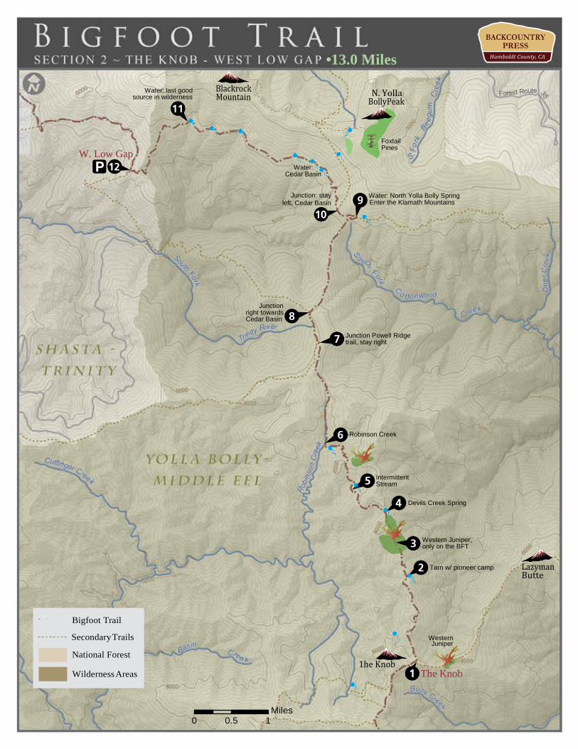
Section 3 | West Low Gap to Red Mountain Creek 25.2 West Low Gap Trailhead (0.0) 27.3 Reach 27N40 and stay right (2.1) 29.0 Stay straight at junction (1.7) 30.6 Right at junction (1.6) 33.2 Right at junction (2.6) 34.2 Follow road, dropping slowly into Trinity River canyon. At a junction with FR 29N30 (also called
30) and take a left (1.0) 36.9 Come to the South Fork National Recreation Trail at a sign along the road. Drop
to river and wade across to a campsite. Trail continues into the woods climbing at first, then contouring nicely above the river (1.9)
36.9 Pacific yew at small creek crossing—continue to contour above the river in and out of ravines through a Douglas-fir dominated forest with black oak and ponderosa pine (1.5)
37.7 Soap Creek crossing with potential camping (0.8) 38.5 Bramlet Place at the edge of the river for the first time. These are private cabins. In front to the
first place is a bristlecone fir—native to the Santa Lucia Mountains of the south-central California coast, quite an interesting find along the Bigfoot Trail. (0.8)
38.6 Stay left after junction at creek (0.1) 40.3 Cross a Red Mountain Creek and come into a meadow with black oak and whiteleaf Manzanita—
this is probably Saint Jacques Place (1.7)
ISBN 978-1-941624-04-3 • use maps with care and proper wilderness preparations • www.backcountrypress.com
Junction: stay straight, then right up Smokey Creek
Water, leave North Fork Smoky Creek
Junction: right, stay in river canyon
Water: Red Mountain Creek
Red Mountain Creek
0 0.5 1
Miles
Wilderness Areas
Bigfoot Trail Mountain Biking Allowed on BFT Secondary Trails
National Forest
● !
!
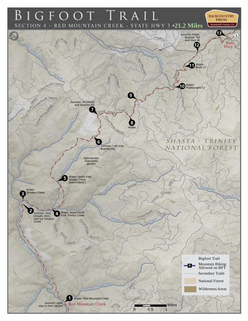
Section 4 | Red Mountain Creek to Highway 3
40.3 Cross Red Mountain Creek and come into a meadow with black oak and whiteleaf manzanita— this is probably Saint Jaques Place (0.0)
44.3 After a long, peaceful amble above the river come to a 4-way junction, continue straight through (4.0)
48.4 Reach another trail junction. Here there is great river access and camping. Take the right up the Smokey Creek Trail to Bramlet Rd (5 miles above). (4.1)
49.7 Leave North Fork Smokey Creek and CLIMB! Fill up your water here too. (1.3) 51.0 After an extremely steep climb, cross a creek in an open area—there is possible camping here,
though water availability varies from year to year (1.3) 54.2 Stay right in open area where a jeep road goes left. For about a mile before this junction all the
way to the 29 junction the trail passes through forest openings with Arctostaphylos canescens and Arctostaphylos manzanita forming incredible manzanita-gardens in the conifer understory. This is occuring because the soil is what is commonly called serpentine (ultramafic and mafic). It is nutrient poor and characterized by evergreen plants like conifers and manzanitas that, with the help of mychorizal fungi, can survive these harsh growing conditions. Serpentine soils is common until you reach Hayfork (it will be a common soil type again in the Red Buttes and Siskiyou wilderness areas). (3.2)
54.9 Junction with FR 29, take a left. On the open serpentine slope to the right (~30 yds) you will have a view to the south toward Mount Linn and the start of the BFT. (0.7)
55.9 Road junction (29N58 to left, stay straight) where intermittent pavement begins on a slow descent to Highway 36. You should have your first views of the Trinity Alps from here (1.0)
57.2 Cross creek 57.9 Another road junction. One sign says 3 miles to 36 the other says 4 miles—continue on the main
road for 4 more miles to 36. (0.7) 59.3 Cross Rattlesnake Creek (1.4) 55.7 Junction with 29N68 and more water. You will also meet your first ghost pines of the trail in the
serpentine outcrops here. (0.2) 60.1 Junction with Highway 36—right. (0.6) 61.5 Meet the junction of Highway 36 and Highway 3, take a left briefly on Highway 3 and quickly
take another left on FR 30N36. Once on 30N36 camping is a possibility. Potential water in creek to west. (1.4)
ISBN 978-1-941624-04-3 • use maps with care and proper wilderness preparations • www.backcountrypress.com
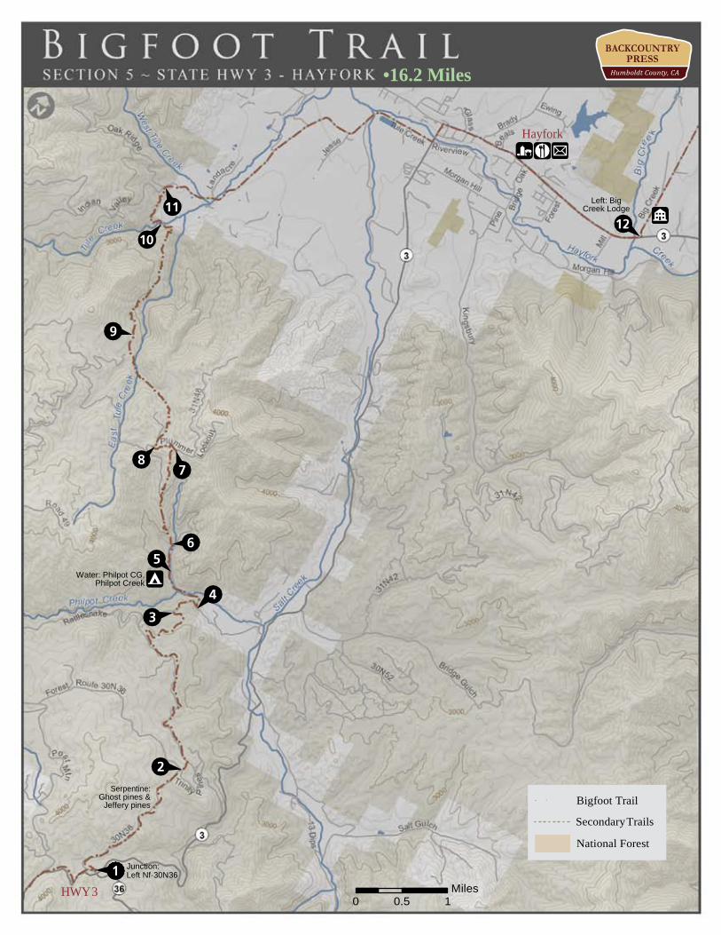
Section 5 | Highway 3 to Hayfork (Big Creek Rd.) 61.5 Meet the junction of Highway 36 and Highway 3, take a left briefly on Highway 3 and quickly
take another left on FR 30N36. Once on 30N36 camping is a possibility. Potential water in creek to west. (0.0)
62.2 Cross onto serpentine and notice the numerous ghost pines that enjoy this habitat, along with Jeffrey pine. (0.7)
63.5 Junction with 30N74—take a right. Sign says “not maintained for travel” If you would like a short-cut, drop due north behind the sign at the junction and you will intersect 30N74 within 0.2 miles (1.3) or…
64.0 Junction with 30N48, stay left on 30N74 and drop. (0.5) 65.4 Trail swings over a ridge of more serpentine. There are good views of the cell towers on Plummer
Peak. As the road descends other conifers include sugar pines, Douglas-firs, and incense-cedars (1.4)
66.1 30N74 intersects FR 353, take a right. (0.7) 66.4 Junction with road to Philpot Campground, there is a creek and restroom 0.2 miles down the
road (0.3) 66.5 Reach Philpot Campground. Follow trail 12W27 north from campground. (0.1) 66.9 Trail Junction with 12W27A which continues along creek to waterfall. Stay left and climb
steep ridgeline. Trail was eliminated by dozer in 2015. We hope to work to rebuild it.. (0.4) 67.7 Intersect road 30N31, walk to the left and watch for trail 12W27 on right (0.8) 67.8 Right on 12W27 (0.1) 68.1 Climb to highpoint (0.3) 68.2 Drop to 30N31, stay left and walk road (Plummer Peak Road) (0.1) 68.4 Intersect 30N31A, walk down road and look for 12W27 dropping into Tule Creek canyon (0.2)
69.9 Trail signage after climbing from the Tule Creek Canyon. Below junction is Upper Tule Creek Falls. (1.5)
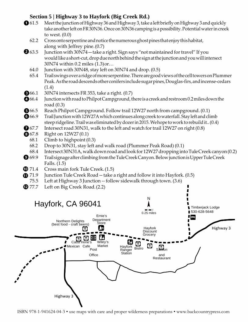
71.4 Cross main fork Tule Creek. (1.5) 71.9 Junction Tule Creek Road -- take a right and follow it into Hayfork. (0.5) 75.5 Left at Highway 3 Junction -- follow sidewalk through town. (3.6) 77.7 Left on Big Creek Road. (2.2)
Hayfork, CA 96041 Ernie’s
N
0.25 miles
Timberjack Lodge 530-628-5648
Northern Delights (best food - craft beers)
Casa Irene’s
Department Store
Wiley’s
Hayfork Discount Grocery
Highway 3
Mexican Cafe Market Post
Hayfork Ranger Bistro Saloon
ption Office Station and Restaurant
Highway 3
ISBN 978-1-941624-04-3 • use maps with care and proper wilderness preparations • www.backcountrypress.com
Section 6 | Hayfork (Big Creek Rd.) to Soldier Creek 77.7 Left on Big Creek Rd. (0.0) 77.9 Timberjack Lodge, the only motel in town, is on right. The lodge was recently remodeled and
rooms have refrigerators to keep your beer cold and microwaves that could be used with supplies from one of the 4 groceries in Hayfork. Call ahead to secure a room. But, you should have cell ser vice for the entire walk from the top of the Smokey Creek trail all the way to Hayfork. (0.2)
82.1 Cross Big Creek on a bridge (4.2) 83.7 After gentle amble along shaded Big Creek Road reach the junction with FR 4N08, stay straight.
(1.6) 85.5 After following the creek with a thick understory of Pacific yew, pavement ends at the Junction
FR 16, stay straight on 33N47 toward Junction City. (1.8) 89.4 Stay left at the junction with 33N84 (3.9) 89.9 Reach a saddle and begin the descent to Junction City. If you need a dry camp,
follow the road east from the saddle for several hundred yards and a camp could be made. I camped here in 2009 and had a Spotted Owl calling through most of the night! (0.5)
92.9 After a long switchback, Cross Soldier Creek with a waterfall (3.0)
ISBN 978-1-941624-04-3 • use maps with care and proper wilderness preparations • www.backcountrypress.com
Section 7 | Soldier Creek to Canyon Creek Trailhead
92.9 Cross Soldier Creek with a waterfall (0.0) 94.0 Hit pavement (1.1) 94.9 Cross Soldier Creek again (0.9) 95.0 Junction 33N51 (0.1) 96.2 Junction with Dutch Creek Rd., stay left and cross Soldier Creek again. (1.2) 96.3 Stay left at Evan’s Bar. (0.1) 98.4 Come to overlook above Trinity River with Ghost pine, Arctostaphylos manzanita and viscida
(2.1) 100.4 Cross the Trinity River (2.0) 100.7 Left at Highway 299 (0.3) 101.0 Reach Junction City (0.3)
Junction City has a small grocery with a post office The store’s hours are 8-8 seven days a week. Sup- plies should be in good order for the trek across the Alps as all staples can be found, as long as you don’t mind some junk food. The zip code at the post office is 96048 and it is reported to be open 9-2 M-F. From here it is 3 days/2 nights of walking to get to Big Flat. Follow Canyon Creek Road to the trail head at the edge of the Trinity Alps Wilderness. You could also hitch east on 299 to Weaverville (~10 miles), with full services.
Notes on Canyon Creek Road: The first 10 miles of this road walk to the Canyon Creek Trailhead passes private property with roadside pot gardens (behind fences) & barking dogs. Camping is dif- ficult to come by until the road crosses to the east side of the river, about 10 miles in. While you are walking adjacent to the creek, water is hard to come by in the first 10ish miles as well as since creek is below steep cliffs below the road or running through private property.
113.4 Walk Canyon Creek Road to the Ripstein Campground (12.4) 114.4 Reach the parking lot/trail head* (1.0)
*From the trail head take the little used Bear Creek Trail and begin climbing on an old mining road (now a single track trail in the wilderness) immediately.
ISBN 978-1-941624-04-3 • use maps with care and proper wilderness preparations • www.backcountrypress.com
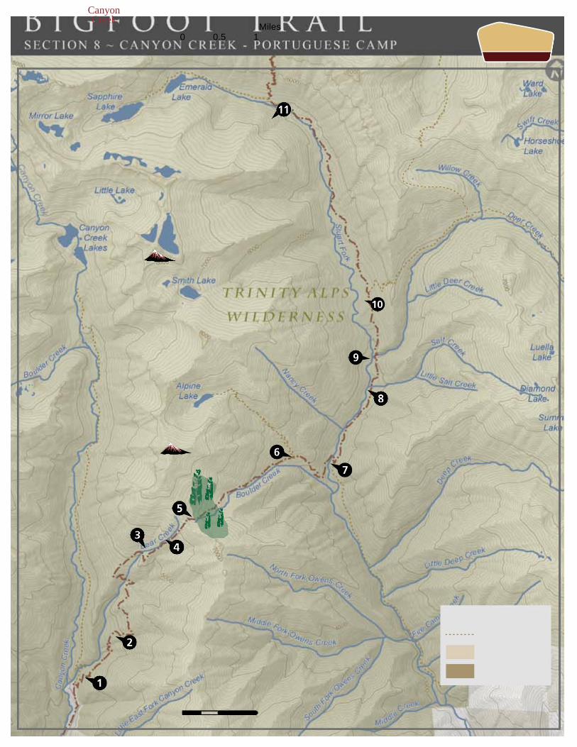
leaving the leviathans to flourish. (0.6) 119.7 Cross the upper reaches of Bear Creek one last time—fill water here if you plan to camp on the
ridge. (0.4) 119.8 Make a dramatic switchback onto a ridgeline through montane chaparral with ponderosa pine
and sugar pine delicately dancing on the ridgeline. From here it gets steep, so get ready to climb. (0.1)
120.3 Reach the saddle and a stark transition from montane chaparral to subalpine forest. Here the first Brewer spruce and mountain hemlock along the Bigfoot Trail flourish in the cooler glade of the north-facing cirque before you. Other conifers also present are western white pine, Shasta fir, white fir, Douglas-fir, and a few scattered knobcone pines. (0.5)
120.4 A small meadow to the east offers nice camping is just off the ridgeline. (0.1) 121.0 Cross small creek in montane chaparral. Continue through rocky montane chaparral
transitioning to mixed-evergreen forest. Trail is often overgrown as of 2011. (0.6) 121.8 Cross stream from Alpine Lake and soon trail, stay right. (0.8) 122.3 Reach Stuarts Fork. This is the most difficult crossing on the BFT—water will be
high into July most years. Cross with CAUTION. Stay left toward Morris Meadows (0.5) 123.5 Cross Salt Creek. (1.2) 123.9 Cross Deer Creek. (0.4) 125.0 Pass through Morris Meadows continue straight (north) passing a series of trails. (1.1) 125.6 Giant ponderosa pine along trail. (0.6) 128.5 Junction with Sawtooth Ridge trail @Portuguese Camp. Climb up to the junction with Caribou Trail. Between 89 and 98 switchbacks will bring you up the 3.1 miles to the ridgeline. (2.9)
ISBN 978-1-941624-04-3 • use maps with care and proper wilderness preparations • www.backcountrypress.com
114.4 Canyon Creek Trailhead. Take Bear Creek Trail (0.0) 115.5 Cross a Bear Creek feeder stream (1.1) 118.2 Enjoy large Douglas-fir forest with a few scattered Pacific yew in the understory. (2.7) 118.6 Cross the south fork of Bear Creek. This canyon has some exceptional shrub diversity with mountain ash, hazelnut, western serviceberry, Oregon boxwood, and mountain alder to name a
118.7 Cross north fork of Bear Creek with Indian rubarb. (0.1) 119.3 Come to ridgeline with possible campsite. From this point the trail begins to contour through
exceptional ponderosa pine forest with sugar pine, white fir, incense-cedar and Douglas-fir mixed in. There has also been a healthy understory burn in this area recently, killing many saplings and
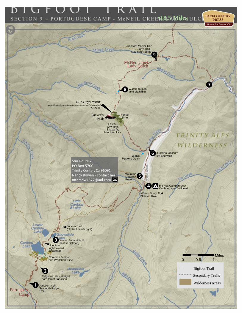
128.5 Junction with Sawtooth Ridge trail @Portuguese Camp. Climb up to the junction with Caribou Trail. Between 89 and 98 switchbacks will carry you up the 3.1 miles to the ridgeline.
131.6 Ridgeline above Caribou Lake, transition from Chaparral to subalpine forest—quite the contrast! (3.1)
132.1 South edge of Big Caribou Lake, watch for prostrate common juniper. (0.5) 133.3 Pass between Lower Caribou Lake and Snowslide Lake. Climb and contour, above the headwaters
of the Salmon River, toward Coffee Creek.(1.2) 140.1 Big Flat Trailhead with bathrooms! (6.8) 140.8 Watch for left to Mountain Meadow Resort, on the left, if resupplying there. Nancy Bowen, who
owns the resort, has been great about taking packages. Be kind! (0.7) 141.5 Post to left (west) of road—Trailhead to Packers Peak. This is the more scenic,
though much more strenuous route which I highly recommend if you have it in you. The over all climb is steep (3,000 feet in 3 miles) but the top of the peak is amazing, with unparalleled views of the wilderness and sublime foxtail pine forest, and then it is a nice ridge walk with a water source within a mile. (0.7)
To Packers Peak: The climb starts from the road and quickly begins to switchback up the mountain 142.1 Trail passes some old mines that are now mostly grown over. (0.6) 142.5 Dense Douglas-fir/White fir forest begins to transition to a more open forest type
with ponderosa pine canopy and greenleaf manzanita (Arctostaphylos patula) understory. (0.4) 142.8 Trail begins to swing onto south face of the peak and forest opens up even more.
Thompson Peak and high Trinity Alps begin to come into view along scree slope. Here Jeffrey pine become common along the ridgeline.(0.3)
143.5 The first foxtail pines begin to be found just before the trail reaches the ridgeline and what may at first appear to be the summit. The forest type makes a noticeable shift as other subalpine species become more common—like Shasta fir, western white pine, and mountain hemlock. There is a spring just over the north side of the ridge from here. (0.7)
144.3 After a more moderate (though still steep) series of switchbacks through fabulous forest, the top of the peak is surely one of the most scenic spots in the Alps. The headwaters of the Salmon River are below and the granite of the Alps is just across the drainage. There was an old fire look out at the top—placed here for good reason. (0.8)
145.5 The trail is well crafted down the north face of the peak where it descends through mountain hemlock and then contours along the ridge below Coyote Peak, eventually reaching the old forest service cabin where the lookout guard spent their nights. There is a nice meadow and spring system here to quench your thirst. (1.2)
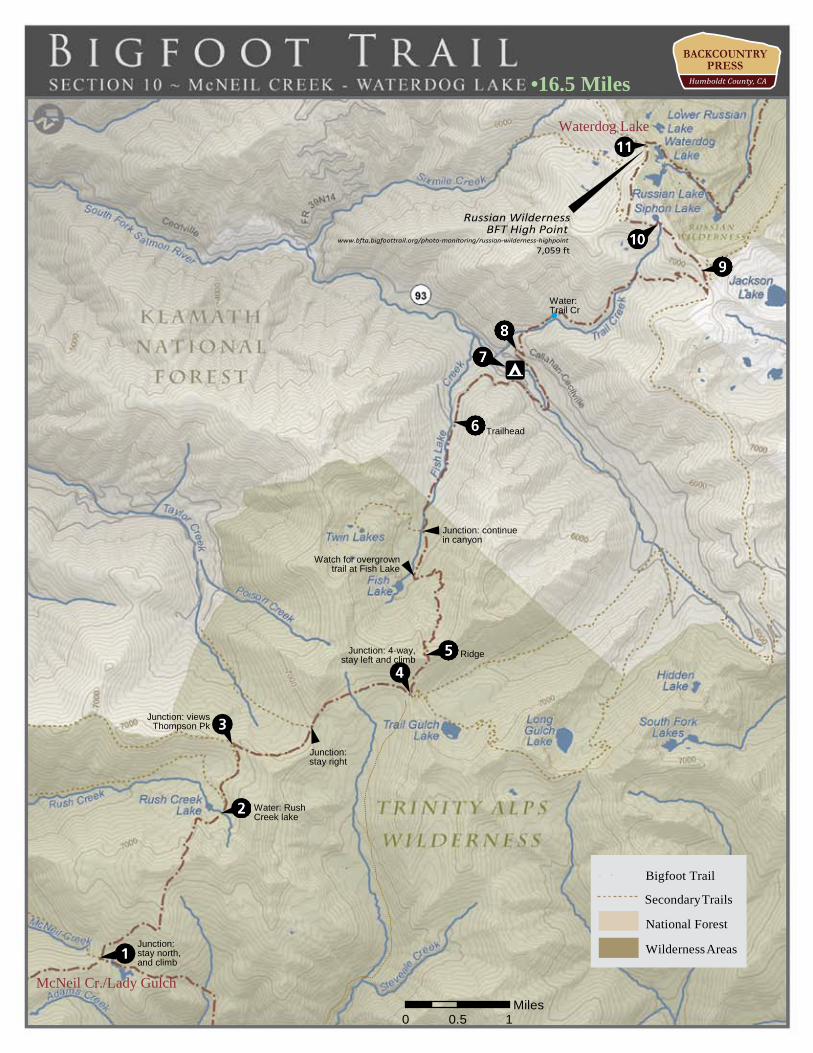
147.0 Continue down the ridgeline with a gentle grade to a saddle and the junction with the Lady Gulch Trail mentioned as a less strenuous route. From Lady Gulch/McNeal Creek junction head north along ridge. (1.5)
ISBN 978-1-941624-04-3 • use maps with care and proper wilderness preparations • www.backcountrypress.com
ALTERNATE: Road walk to Lady Gulch trail is a less strenuous way to return to the Bigfoot Trail. It does require a lon- ger road walk but the return to the trail is nearly 1,500 feet less elevation gain.
The Hike: Continue along road for 4.3 miles from Mountain Meadow Resort to Lady Gulch Trail signed simply as “Trail” and climb 3.0 miles to junction. 1.7 up trail is a creek with camping, 1.0 cross another creek, 0.3 traverse meadow to junction along ridgeline
Section 10 | McNeil Creek/Lady Gulch trail junction to Waterdog Lake
147.0 Continue down the ridgeline with a gentle grade to a saddle and the junction with the Lady Gulch Trail mentioned as a less strenuous route. From Lady Gulch/McNeal Creek junction head north along ridge.
the lake. (1.0) 149.7 At trail junction, stay high and right (0.1) 150.3 Along ridgeline reach a trail junction and take a right and climb with views of
Thompson Peak (0.6) 151.0 Come to a saddle junction with Poison Lake Trail—though there is no sign.
Contour along east face below Poison Peak, contouring gently down, gaining views of Mount Lassen—the first since the Yolla Bolly Wilderness. (0.7)
Wilderness, and lots of Trinity Alps views (0.7) 154.2 After a long drop with many switchbacks, reach Fish Lake. Stay on the east side
of the outlet and travel north, watching for trail closely through willows.(1.4) 155.2 Cross Creek, stay on the east (right) side and walk, waiting for trail to improve (1.0) 155.5 Cross again—back to east side (0.3) 155.8 Trailhead—follow road ignoring service roads that branch. (0.3) 157.2 Pass Trail Creek Campground with restrooms. (1.4) 158.2 Intersection with paved FR 93—right (1.0) 158.3 Left on FR 39N06 (0.1) 158.6 Cross creek and follow (OHV) trail on the right. (0.3) 159.0 Creek (0.4) 160.3 Cross Trail Creek from Siphon Lake (1.3) 160.8 Right at campsite on Foster Mine (OHV) Road (0.5) 161.1 Reach a junction and go left (NW) onto Pacific Crest Trail (0.3) 161.3 Quickly leave PCT following signs to Siphon Lake—left (0.2) 162.0 Reach Siphon Lake via OHV road—camping on ridgeline above lake is spectacular.
Continue past lake (0.7) 162.4 Trail becomes single track (0.4) 162.9 Climb up and over ridge to Russian Lake. Stay on South Face of ridge (0.5) and drop to… 163.3 Wilderness boundary and take a trail to the right to Water Dog Lake (0.4) 163.5 Outlet to Waterdog Lake. Walk along north side of lake and at the east end,
climb up on small saddle, which is the divide between Waterdog and Russian Lakes. Follow the trail down (0.2)
ISBN 978-1-941624-04-3 • use maps with care and proper wilderness preparations • www.backcountrypress.com
147.7 Cross several small creeks (0.7) 148.6 Reach ridgeline saddle above Rush Creek Lake. (0.9) 149.6 Drop through beautiful granite to Rush Creek Lake, stay right at junction above
151.5 Water (0.5) 152.1 4-way junction. Take a left, climbing up and southwest the hillside (0.6) and eventually… 152.8 To a ridgeline saddle/pass with views of Shasta, McLoughlin, Russian
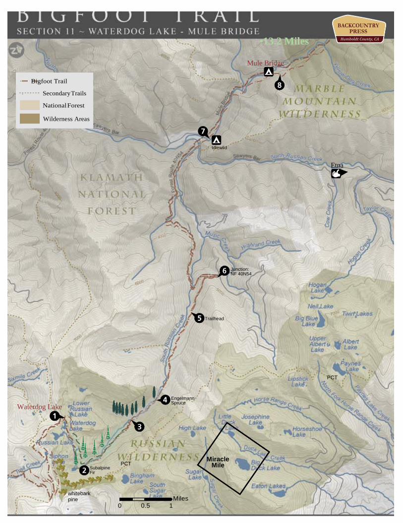
163.5 Outlet to Waterdog Lake. Walk along north side of lake and at the east end climb up on small saddle, which is the divide between Waterdog and Russian Lakes. Follow the trail down (0.2)
164.1 Cross creek drainage below Russian Lake—begin to watch for the subalpine firs that are quite common in this drainage. (0.6)
164.7 Meadow—Subalpine fir reach exquisite size in this canyon, probably as big as the species gets in California. (0.6)
166.2 Meadow (1.5) 166.7 In a second, smaller meadow, there is a big cairn. 100 feet south is a large
Engelmann spruce. (0.5) 168.1 As a small creek meanders over the trail Engelmann spruce become common,
mixed with ponderosa pines. This is a rare vegetation type indeed! (1.4)
is $10.00 with a restroom and river swimming. (4.5) 174.4 Idlewild Campground. Follow road to Mule Bridge Trailhead. (0.1) 176.7 Cross the Mule Bridge in mixed evergreen forest. (2.3)
ISBN 978-1-941624-04-3 • use maps with care and proper wilderness preparations • www.backcountrypress.com
Whites Fire in 2014 affected this forest
168.7 Creek (0.6) 168.9 Trailhead (0.2) 169.8 Left at junction with FR 40N54 (0.9) 174.3 Meet the Salmon River Road and take a left, quickly cross river on a bridge, and take the first right at the signed Idlewild Campground (FR 40N47). Camping here
176.7 Cross the Mule Bridge in mixed evergreen forest, follow road to Mule Bridge Trailhead. Cross the Mule Bridge in mixed evergreen forest. Immediately pick up Pacific yew across the bridge along with Douglas-fir and incense-cedar. (0.0)
There are just a few, you can find more in the Red Buttes. (0.7) 181.7 Cross Deer Creek (0.3) 182.8 Reach junction with Shelly Meadow Trail. Pacific yews are much more common
and almost dominate along the banks of the river. There is a good campsite at this junction. The Shelly Meadow Trail will bring you to the Pacific Crest Trail and also subalpine fir in the meadow—a rare conifer in the Klamath Mountains.(1.1)
mixed-conifer forest dominated by white fir. (0.6) 187.5 Before the last crossing of the North Fork, watch for quaking aspen (Populus tremuloides),
generally rare in the Klamath. Here they grow all the way through the canyon to English Lake forming one of the largest stands, with the largest specimens, I have seen in the area. (0.7)
188.0 Intersect Bug Gulch Trail. Trees all reach immense size here. Just past the junction are impressive incense-cedar, ponderosa pine, white fir and sugar pine. (0.5)
To Wooley Creek: Take a right and climb the Bug Gulch Trail. 188.4 Cross Pierce’s Draw (can be dry). (0.4) 189.0 Junction Kathleen and Ethel Lake. (0.6) 190.4 Ridgeline in Shasta fir forest with a view to Marble Mountain. (1.4) 191.0 Drop to unsigned junction to Wild Lake (0.6) 191.4 Big Meadow trail junction—Drop, drop, drop. Last water until Wooley Creek in dry years. (0.4)
ISBN 978-1-941624-04-3 • use maps with care and proper wilderness preparations • www.backcountrypress.com
From here it is 3 miles to Diamond Lake and the most spectacular Pacific silver fir (Abies amabilis) for- est in California. Climb trail to junction just below English Lake (1.7) stay right, switch backing up the mountain for another 1.1 miles to the lake.
177.7 Cross Yellow Dog Creek (1.0) 178.3 Switchback up away from creek (0.6) 178.8 Switchback down with five-fingered fern (Adiantum aleuticum) as Ponderosa pine and sugar
pine become more common (0.5) 179.9 Cross Big Creek with white fir and fabulous swimming holes (1.1) 180.7 Come to the second Mule Bridge; look up canyon to Bear Wallow Peak (0.8) 181.4 Leave old homestead property at a gate. Look across the river for knobcone pine.
183.3 Cross North Fork and climb (0.5) 184.5 Cross North Fork. (1.2) 185.5 Again…ford the North Fork (1.0) 186.2 Cross Boulder Creek and then the North Fork again (0.7) 186.8 Reach junction with Island Lake trail. At the junction look for Sadler oak (Quercus sadleriana) a Klamath endemic, as well as Oregon boxwood (Paxistima myrsinites). Soon you enter a pure
191.4 Big Meadow trail junction—Drop, drop, drop (0.0) 195.5 Reach and ford Wooley Creek. Follow trail across the creek, climbing to the south—which is not
the intuitive route but the trail will lead you correctly. (4.1) 195.7 At junction, take a right. (0.2) 197.8 After several terrific swimming holes reach Anthony Milne Camp (2.6) 199.3 Cross small creek (1.5) 199.8 Water (0.5) 200.7 Wooley Pocket Creek (0.9) 201.6 Ananias Camp—cross Big Elk Fork. Elk are a possibility through here. (0.9) 202.3 Trail junction—right (0.7) 203.0 Junction with PCT. Around this 4-way junction watch for subalpine fir (Abies lasiocarpa) in addition to white and Shasta fir. Drop northward to Little Marble Valley and enjoy a well-worn
path for the next few days! (0.7) 203.8 Trail levels out at the Marble Valley Guard Station (0.8) 204.1 Stay right at the junction with the Marble Gap Trail—which forks left. (0.3) 204.8 Soon come to a spring in a meadow where bands of marble come close to the trail. From this spot
it is a quick (30 minute) climb up through the drainage and over bands of marble to the ridge known as Marble Mountain. Near the summit is a spectacular stand of foxtail pines. This adventure is well worth your time—drop your pack safely off the trail and make the climb. While climbing watch out for the many eroded caves in the marble—skeletons from critters, including species that lived here in the Pleistocene, have been found in these caves by the spelunkers who visit each summer. (0.7)
206.4 Just before the junction with the Box Camp Trail there are a few foxtail pine in the switchbacks up through the marble—just before Big Rock Camp. (1.6)
208.4 Traverse the headwaters of South Fork Kelsey Creek and drop to a notch to a junction with the Rye Patch Trail—stay left. (2.0)
208.6 Reach murky Paradise Lake (0.2)
ISBN 978-1-941624-04-3 • use maps with care and proper wilderness preparations • www.backcountrypress.com
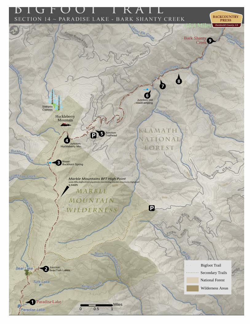
white fir. This is the last place to see foxtail pines along the Bigfoot Trail. (0.6)
camping spots in the trees. (3.0) 213.9 Just after the spring the trail drops to a flat area and onto serpentine with a small
pond—watch for lodgepole pine and abundant bear grass. (0.3) 214.8 Reach a saddle and burn on the ridge to Huckleberry Mountain. The trail to the top is not easy
to follow because of the burn. On the other side of the mountain (about a mile off trail to the west) grows the rare Siskiyou cypress—though an adventure to find them, this is the closest the trail come to this species. (0.9)
216.2 After leaving the wilderness the trail crosses the Cold Spring Trailhead (though the spring is a mile down the road) and switchbacks gradually down the mountain on an old road. (1.4)
another old road crossing. (1.9) 220.6 Cross Grider Creek on a footbridge and briefly enter a serpentine landscape. This bridge burned
in the summer of 2014. (0.7) 221.9 Cross footbridge with possible camping. This bridge also burned in the summer of 2014. (1.3) 223.6 Cross footbridge (1.7) 224.0 Cross Bark Shanty Creek and reliable water. (0.4)
ISBN 978-1-941624-04-3 • use maps with care and proper wilderness preparations • www.backcountrypress.com
208.6 Reach murky Paradise Lake (0.0) 209.2 Spring (0.6) 209.8 Round a corner and the dense forest quickly ends as the trail passes onto serpentine. A few
hundred feet after this transition watch for >10 foxtail pines up on the ridge west of trail in addition to incense-cedar, mountain hemlock, Jeffrey pine, western white pine, Shasta fir and
210.0 Junction with Turk Lake/Bear Lake Trails (0.2) 210.6 Climb to a ridgeline with many Jeffrey pines and beautiful views back to Kings Castle. (0.6) 213.6 In a meadow with abundant corn lilies pass Buckhorn Springs—just beyond and before there are
217.1 Cross a road (0.9) 218.0 Cross a road—soon enter old-growth forest. (0.9) 219.9 Leave old-growth and cross Cold Spring Creek and come quickly to both a camping spot and
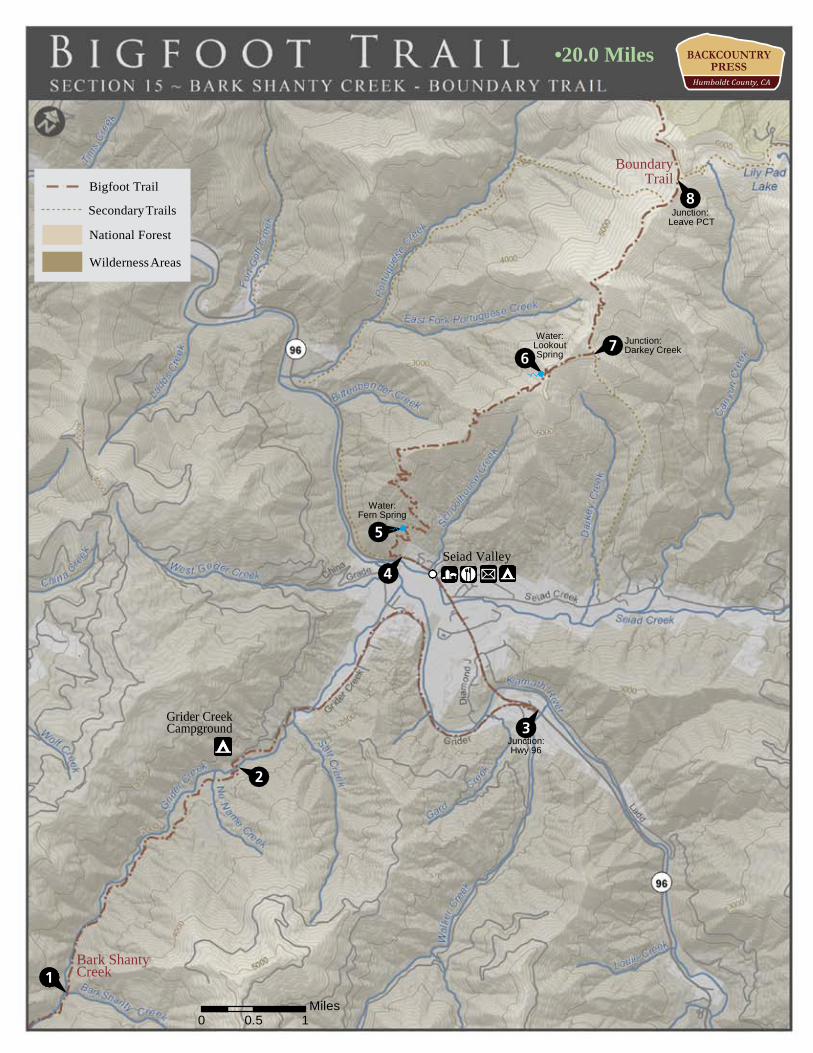
Section 15 | Bark Shanty Creek to Boundary Trail 224.0 Cross Bark Shanty Creek and reliable water. (0.0) 227.0 After generally contouring high above Grider Creek gradually drop to the final footbridge
crossing and come to Grider Creek Campground with pit toilets. This is where the trail becomes a road walk. The Pacific Crest Trail Association is working to make this stretch single track, but for now the route must avoid private land and use the bridge on Highway 96 to cross the Klamath River. Follow 46N24X from the campground. (3.0)
(0.9)
ferns. Fill up here, it will be the last dependable water for nearly 11 miles. (4.8) 241.1 Junction with Darkey Creek Trail—Brewer spruce abound on the north face of Middle Devil’s
Peak. Watch for an even-aged stand of knobcone pine through here. (0.8) 244.0 Junction with the Boundary Trail—leave the PCT here and head west my friend. (2.9)
ISBN 978-1-941624-04-3 • use maps with care and proper wilderness preparations • www.backcountrypress.com
227.3 Make a right on 46N66 (0.3) 229.4 Cross Grider Creek (2.1) 230.8 Pavement begins (1.4) 233.0 Meet Highway 96 and take a left (2.2) 233.4 Cross Klamath River (0.4) 234.3 Enter the town of Seiad valley with Camping at the RV Park (laundry and showers). There is a
restaurant (7:00-2:00 each day) and a store with a limited selection of food, but which caters to the backpacker in summer. After the re-supply, walk west on 96 for half a mile to get to the trail.
234.8 Signed junction with PCT and get ready to climb! (0.5) 235.6 Fern Spring (0.7) 240.3 Reach Lookout Spring after a long but gradual ascent—the spring is 10 yards to the west of the trail. The pipe-fed spring is nestled under the shade of Douglas-firs and surrounded by 5-fingered
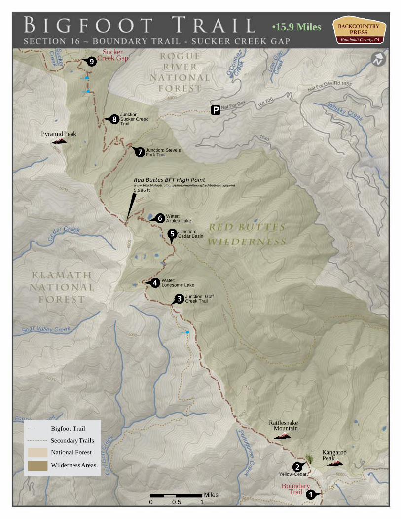
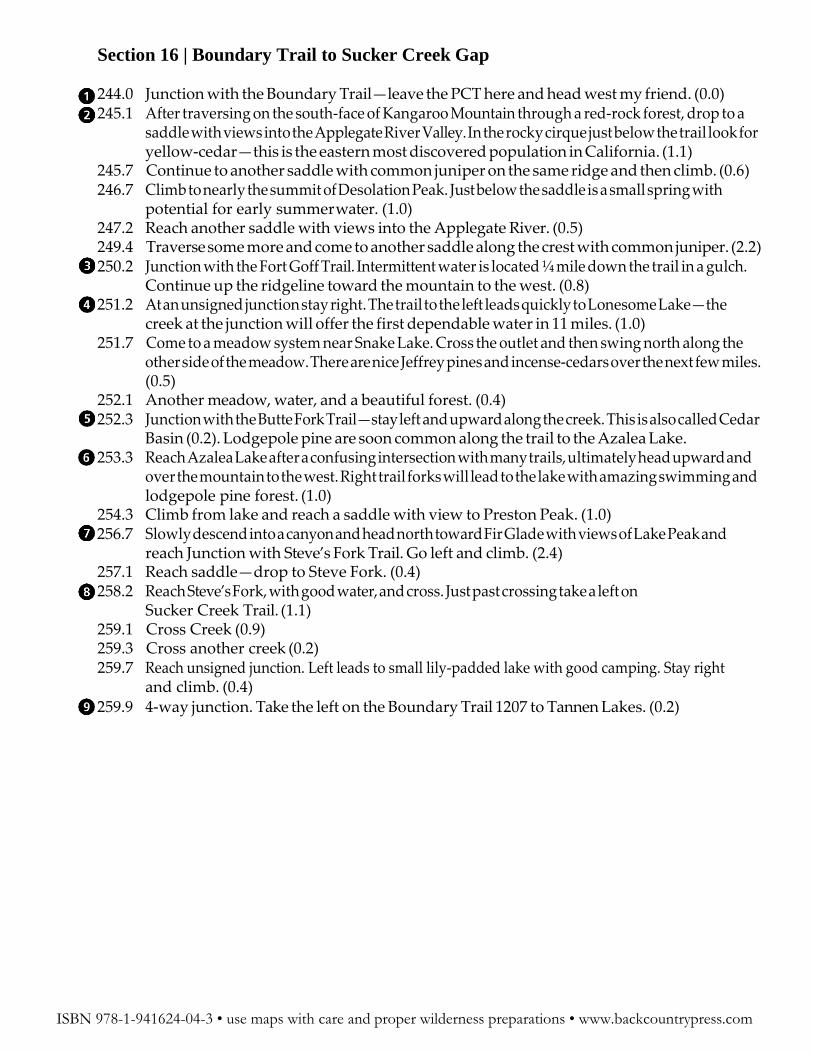
244.0 Junction with the Boundary Trail—leave the PCT here and head west my friend. (0.0) 245.1 After traversing on the south-face of Kangaroo Mountain through a red-rock forest, drop to a
saddle with views into the Applegate River Valley. In the rocky cirque just below the trail look for yellow-cedar—this is the eastern most discovered population in California. (1.1)
245.7 Continue to another saddle with common juniper on the same ridge and then climb. (0.6) 246.7 Climb to nearly the summit of Desolation Peak. Just below the saddle is a small spring with
potential for early summer water. (1.0) 247.2 Reach another saddle with views into the Applegate River. (0.5) 249.4 Traverse some more and come to another saddle along the crest with common juniper. (2.2) 250.2 Junction with the Fort Goff Trail. Intermittent water is located ¼ mile down the trail in a gulch.
Continue up the ridgeline toward the mountain to the west. (0.8) 251.2 At an unsigned junction stay right. The trail to the left leads quickly to Lonesome Lake—the
creek at the junction will offer the first dependable water in 11 miles. (1.0) 251.7 Come to a meadow system near Snake Lake. Cross the outlet and then swing north along the
other side of the meadow. There are nice Jeffrey pines and incense-cedars over the next few miles. (0.5)
252.1 Another meadow, water, and a beautiful forest. (0.4) 252.3 Junction with the Butte Fork Trail—stay left and upward along the creek. This is also called Cedar
Basin (0.2). Lodgepole pine are soon common along the trail to the Azalea Lake. 253.3 Reach Azalea Lake after a confusing intersection with many trails, ultimately head upward and
over the mountain to the west. Right trail forks will lead to the lake with amazing swimming and lodgepole pine forest. (1.0)
254.3 Climb from lake and reach a saddle with view to Preston Peak. (1.0) 256.7 Slowly descend into a canyon and head north toward Fir Glade with views of Lake Peak and
reach Junction with Steve’s Fork Trail. Go left and climb. (2.4) 257.1 Reach saddle—drop to Steve Fork. (0.4) 258.2 Reach Steve’s Fork, with good water, and cross. Just past crossing take a left on
Sucker Creek Trail. (1.1) 259.1 Cross Creek (0.9) 259.3 Cross another creek (0.2) 259.7 Reach unsigned junction. Left leads to small lily-padded lake with good camping. Stay right
and climb. (0.4) 259.9 4-way junction. Take the left on the Boundary Trail 1207 to Tannen Lakes. (0.2)
ISBN 978-1-941624-04-3 • use maps with care and proper wilderness preparations • www.backcountrypress.com
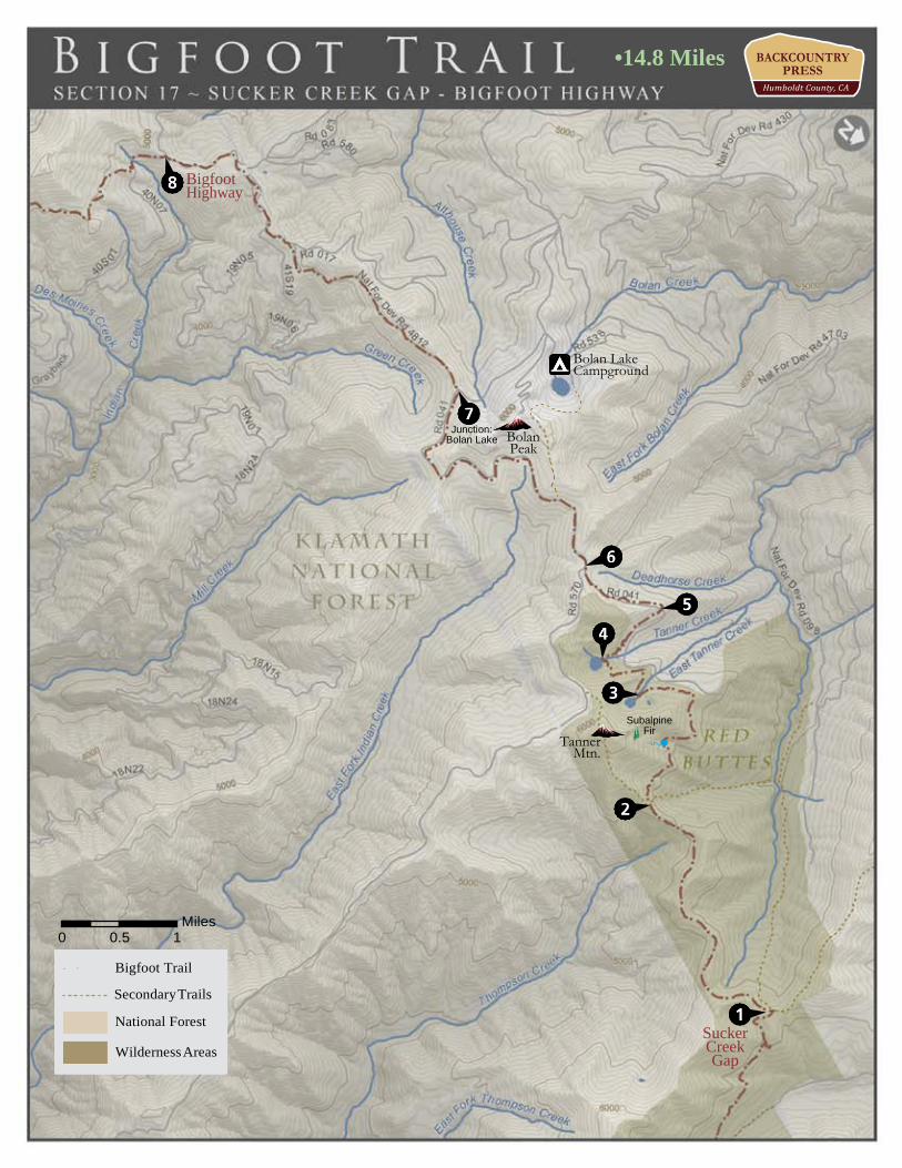
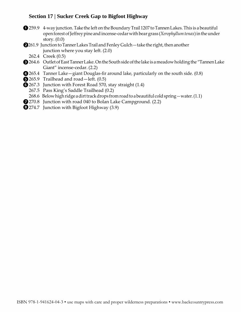
259.9 4-way junction. Take the left on the Boundary Trail 1207 to Tannen Lakes. This is a beautiful open forest of Jeffrey pine and incense-cedar with bear grass (Xerophyllum tenax) in the under story. (0.0)
261.9 Junction to Tanner Lakes Trail and Fenley Gulch—take the right, then another junction where you stay left. (2.0)
262.4 Creek (0.5) 264.6 Outlet of East Tanner Lake. On the South side of the lake is a meadow holding the “Tannen Lake
Giant” incense-cedar. (2.2) 265.4 Tanner Lake—giant Douglas-fir around lake, particularly on the south side. (0.8) 265.9 Trailhead and road—left. (0.5) 267.3 Junction with Forest Road 570, stay straight (1.4) 267.5 Pass King’s Saddle Trailhead (0.2) 268.6 Below high ridge a dirt track drops from road to a beautiful cold spring—water. (1.1) 270.8 Junction with road 040 to Bolan Lake Campground. (2.2) 274.7 Junction with Bigfoot Highway (3.9)
ISBN 978-1-941624-04-3 • use maps with care and proper wilderness preparations • www.backcountrypress.com
Alternate Route: Flagged and under construction but incomplete as of summer 2015
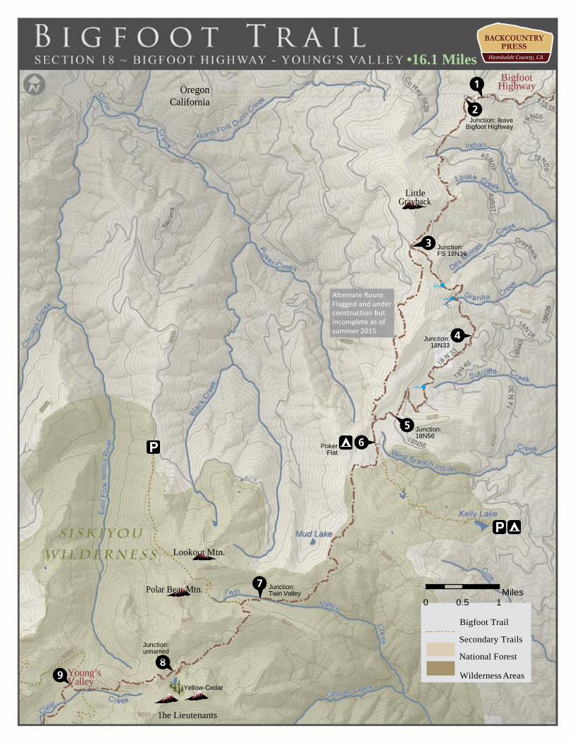
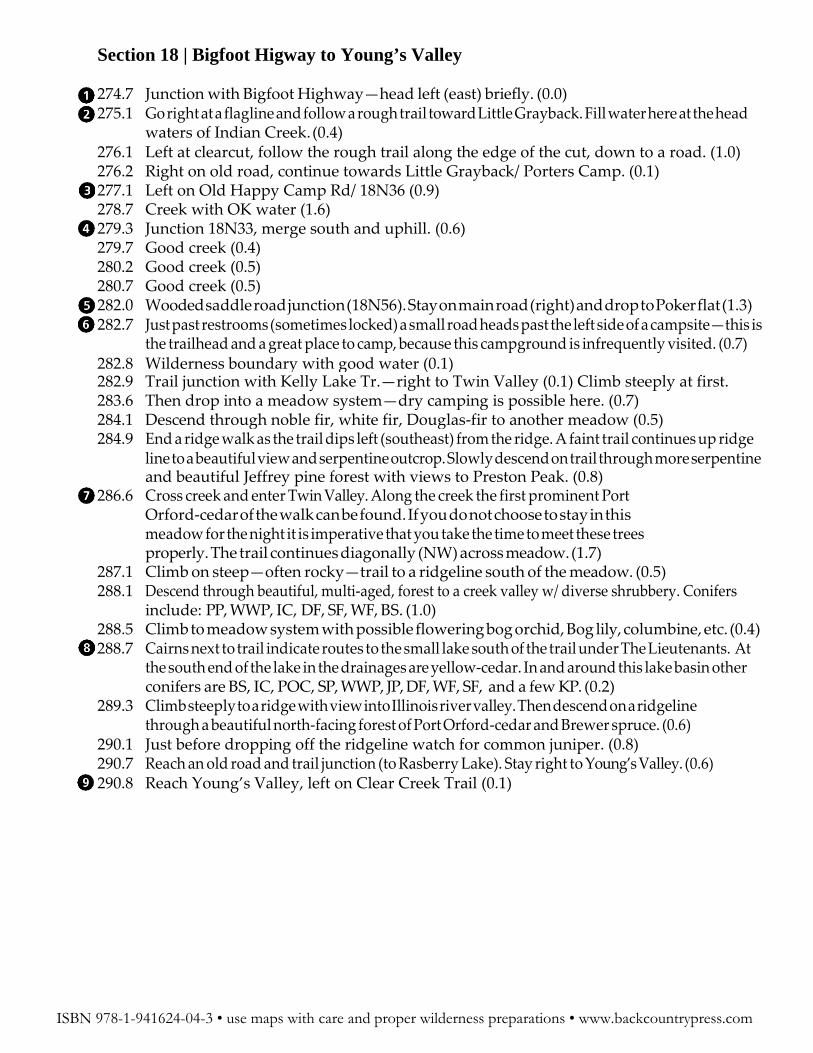
Section 18 | Bigfoot Higway to Young’s Valley
274.7 Junction with Bigfoot Highway—head left (east) briefly. (0.0) 275.1 Go right at a flagline and follow a rough trail toward Little Grayback. Fill water here at the head
waters of Indian Creek. (0.4) 276.1 Left at clearcut, follow the rough trail along the edge of the cut, down to a road. (1.0) 276.2 Right on old road, continue towards Little Grayback/ Porters Camp. (0.1) 277.1 Left on Old Happy Camp Rd/ 18N36 (0.9) 278.7 Creek with OK water (1.6) 279.3 Junction 18N33, merge south and uphill. (0.6) 279.7 Good creek (0.4) 280.2 Good creek (0.5) 280.7 Good creek (0.5) 282.0 Wooded saddle road junction (18N56). Stay on main road (right) and drop to Poker flat (1.3) 282.7 Just past restrooms (sometimes locked) a small road heads past the left side of a campsite—this is
the trailhead and a great place to camp, because this campground is infrequently visited. (0.7) 282.8 Wilderness boundary with good water (0.1) 282.9 Trail junction with Kelly Lake Tr.—right to Twin Valley (0.1) Climb steeply at first. 283.6 Then drop into a meadow system—dry camping is possible here. (0.7) 284.1 Descend through noble fir, white fir, Douglas-fir to another meadow (0.5) 284.9 End a ridge walk as the trail dips left (southeast) from the ridge. A faint trail continues up ridge line to a beautiful view and serpentine outcrop. Slowly descend on trail through more serpentine
and beautiful Jeffrey pine forest with views to Preston Peak. (0.8) 286.6 Cross creek and enter Twin Valley. Along the creek the first prominent Port
Orford-cedar of the walk can be found. If you do not choose to stay in this meadow for the night it is imperative that you take the time to meet these trees properly. The trail continues diagonally (NW) across meadow. (1.7)
287.1 Climb on steep—often rocky—trail to a ridgeline south of the meadow. (0.5) 288.1 Descend through beautiful, multi-aged, forest to a creek valley w/ diverse shrubbery. Conifers
include: PP, WWP, IC, DF, SF, WF, BS. (1.0) 288.5 Climb to meadow system with possible flowering bog orchid, Bog lily, columbine, etc. (0.4) 288.7 Cairns next to trail indicate routes to the small lake south of the trail under The Lieutenants. At
the south end of the lake in the drainages are yellow-cedar. In and around this lake basin other conifers are BS, IC, POC, SP, WWP, JP, DF, WF, SF, and a few KP. (0.2)
289.3 Climb steeply to a ridge with view into Illinois river valley. Then descend on a ridgeline through a beautiful north-facing forest of Port Orford-cedar and Brewer spruce. (0.6)
290.1 Just before dropping off the ridgeline watch for common juniper. (0.8) 290.7 Reach an old road and trail junction (to Rasberry Lake). Stay right to Young’s Valley. (0.6) 290.8 Reach Young’s Valley, left on Clear Creek Trail (0.1)
ISBN 978-1-941624-04-3 • use maps with care and proper wilderness preparations • www.backcountrypress.com
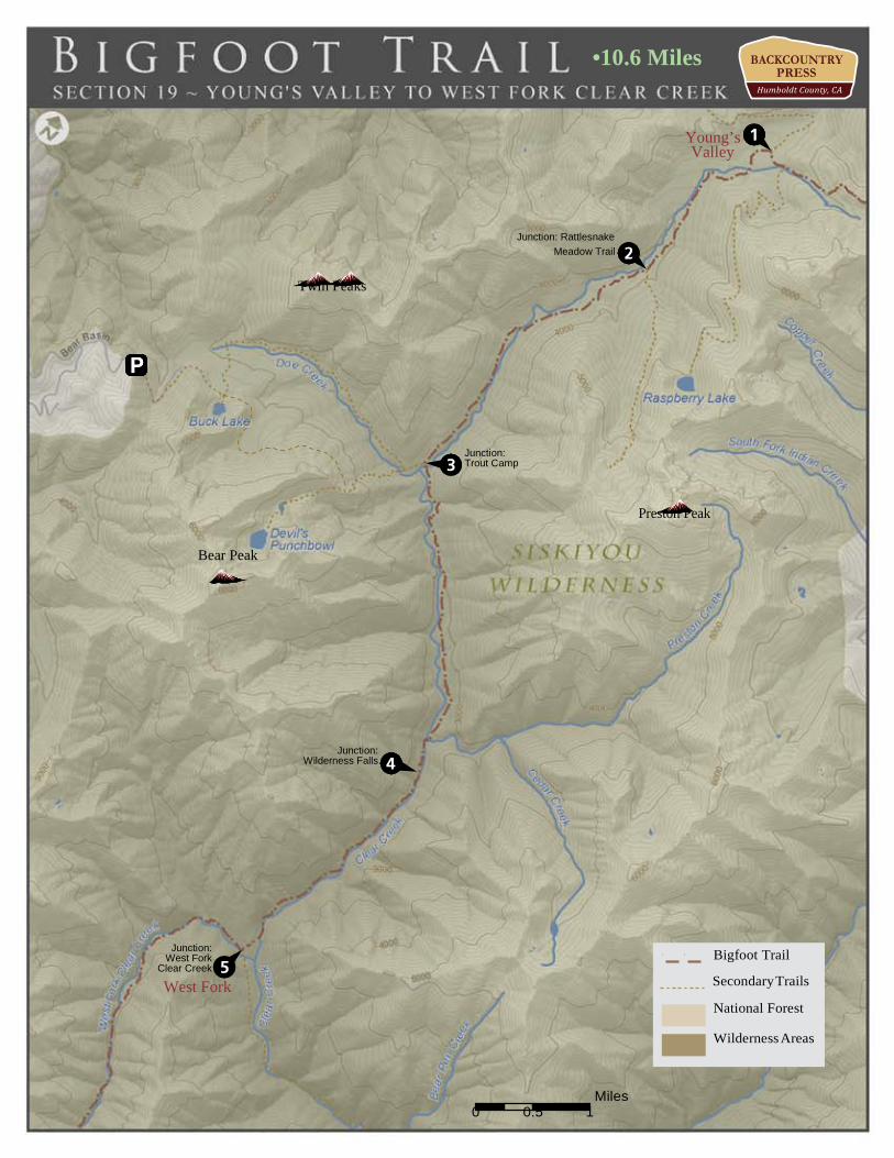
Section 19 | Young’s Valley to West Fork Clear Creek
Bolander’s Lily. (1.5)
ISBN 978-1-941624-04-3 • use maps with care and proper wilderness preparations • www.backcountrypress.com
290.8 Reach Young’s Valley, left on Clear Creek Trail (0.0) 290.9 Make a left from the old road to the much narrower Clear Creek Trail (0.1) 291.3 Cross the headwaters of Clear Creek—beautiful Port Orford-cedars! (0.4) 292.6 Cross a creek. Immediately after the crossing is the junction to Rattlesnake Meadow. (1.3) 294.1 Cross Clear Creek to the south side. Just beyond the trail passed onto serpentine. Watch for lodgepole pine, darlingtonia, California lady slipper and the rare and endemic
295.7 Cross Clear Creek at Trout Camp with potential, but often popular, camping. (1.6) 298.4 Cross Clear Creek again at a campsite just upstream from Wilderness Falls.(2.7) 298.6 Wilderness Falls! You best do some swimming. (0.2) 301.4 Just before the crossing of the West Fork watch for a small cairn under some oaks. Look for the
log cuts just south of the junction and follow this seldom used trail through brushy conditions. (2.8)
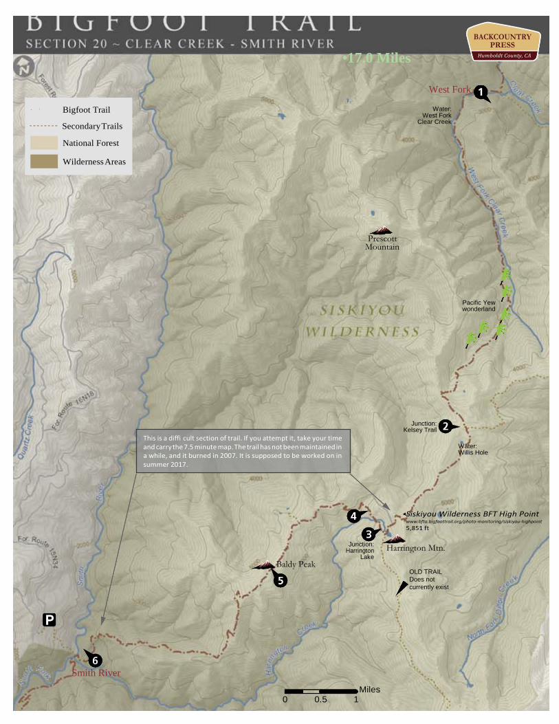
Siskiyou Wilderness BFT High Point www.bfta.bigfoottrail.org/photo-monitoring/siskiyou-highpoint 5,851 ft
Harrington Mtn.
OLD TRAIL Does not currently exist
Smith River
0 0.5 1
Miles
Wilderness Areas
This is a diffi cult section of trail. If you attempt it, take your time and carry the 7.5 minute map. The trail has not been maintained in a while, and it burned in 2007. It is supposed to be worked on in summer 2017.
301.4 West Fork (0.0) 301.9 Cross a stream. Just before the crossing there are a few substantially large POC. (0.5) 302.3 Cross West Fork (0.4) 303.0 Cross again just before a campsite. (0.7) 303.3 Cross to the east side then immediately to the west side (0.3) 303.6 Cross to the east side (0.3) 303.8 Cross west and the immediately to the east again. (0.2) Now switchback up and away from the creek for awhile. This is primordial Siskiyou forest with Port Orford-cedar and Douglas-fir
canopy with a few sugar pines. The understory is thick with Pacific yew and Sadler oak. 305.0 Cross creek. Start monitoring your water at this point, especially in dry years. (1.2) 306.0 Level out briefly in a stately POC-DF forest and cross a small creek. Continue
to climb steeply (1.0) 306.9 After final switchbacks in POC, NF, WF reach a saddle (0.9) 307.6 Descend, sometime steeply, and then climb to junction with the Kelsey Trail (0.7) 307.7 Reach Willis Hole and a beautiful meadow of Darlingtonia. This meadow is named for the famed
botanist Willis Jepson. Traverse through beautiful forest and then along a ridgeline. The evenly spaced forest holds some beautiful and healthy western white pine specimens. Water can be good here, but generally only early in the season. Fill up if you can! (0.1)
309.1 Climb to a saddle on Harrington Mountain. (1.4) This is where is starts to get challenging – get ready to use some good navigation skills!
309.8 Switchback down and then traverse a ridge through a burn area from 2008. Just before the ridge climbs again, drop immediately to the south, steeply, and toward a meadow that can be seen through the trees. (0.7)
310.3 Reach overgrown Harrington Lake after contouring hillside. Cross outlet to the lake and cross your fingers that the trail becomes evident. If it does not, follow the creek outlet (that soon disappears in meadows) downward. (0.5)
310.8 As the creek reappears cross it north toward a flat meadow with large incense-cedars and contour up another drainage to the north. (0.5)
311.1 Cross a creek in the new drainage and walk on flat terrain. There is an old campsite across the creek, probably one used by travelers of the Kelsey Trail many years ago. Get a lot of water here as it becomes scarce until the Smith River. Switchback up soon after. (0.3)
313.1 Follow the ridgeline to the summit of Baldy Peak. Several trails branch out near the top—all of which reach the summit. Get ready for a challenge! (2.0)
313.9 Drop from the burn, following the ridgeline generally in a southwest direction, into forest/chaparral. The trail here is overgrown but evident (0.8)
314.7 After traversing talus drop steeply through huckleberry oak (0.8) 315.3 After a slow descent though brush and trees, and after several switchbacks, enter
a dense Douglas-fir forest. Descend just below the ridgeline for almost 3 miles on an old, well contoured trail. Salal, evergreen huckleberry, rhododendrons, redwood sorrel begin to grow as the coast gets closer. (0.6)
317.3 Trail reaches confusing saddle in madrone near ridge. Stay on the north side of the ridge for 0.3 more miles then look to cross the ridgeline and descend. (2.0)
317.9 Drop to Gunbarrel Slide. The trail wraps west through meadow. Though it is hard to follow you will ultimately drop to the Smith River through poison oak. (0.6)
318.4 Meet Smith River and travel downstream along a gravelly river bank to a crossing with Harrington Creek. Cross the creek and stay near the Smith River and Gunbarrel camp. (0.5)
ISBN 978-1-941624-04-3 • use maps with care and proper wilderness preparations • www.backcountrypress.com
Section 21 | Smith River to Rattlesnake Road 318.4 Meet Smith River and travel downstream along a gravelly river bank to a crossing with
Harrington Creek. Cross the creek and stay near the Smith River and Gunbarrel camp. (0.0) 318.6 Switchback up from gunbarrel camp (0.2) 319.4 Gnarly creek crossing with good water. (0.8) 319.5 Switchback up and there is a sign! (0.1) 320.1 Creek (0.6) 320.6 Switchback down to old trail junction, stay left. (0.5) 321.0 Cross a big creek. (0.4) 321.9 Cross Eightmile Creek with terrific swimming and camping on the other side and the junction of
the creek and river. (0.9) 322.6 Elkhorn Bar camp (0.7) 322.7 Junction Summit valley LO Trail (0.1) 322.8 Creek (0.1) 323.8 Leave wilderness (1.0) 324.3 Reach Buck Creek and the Buck Creek Shelter (0.5) 325.2 Creek (0.9) 325.5 Port Orford-cedar grove worth mentioning (0.3) 325.7 Trail junction. Stay straight or take a left—both lead to the trailhead. (.2) 325.9 Reach trailhead with a restroom (0.2) 328.1 Climb road to junction with G-O Road. Take a right. (2.2) 331.7 Cross the Smith River on a bridge. REDWOODS!. Take a left on 427 and follow the South Fork of
the Smith River—with LOTS of swimming. (3.6) Right takes yoou to Big Flat campground and the alternate route.
332.7 Cross smith River on Bridge. Nice spring on opposite side. (1.0) 333.4 Notice small pull-out on the right side of the road. Follow a trail into the woods... (0.7) 333.5 ...To a campsite. Take a left—this is probably the old Kelsey trail. Take advantage of the
swimming. (0.1) 333.8 Old-growth redwood, creek (0.3) 334.0 Rejoin the road (0.2) 336.9 Take a road walk to the junction Rattlesnake Lake road. (2.9)
ISBN 978-1-941624-04-3 • use maps with care and proper wilderness preparations • www.backcountrypress.com
An alternate, single-track trail is under construction if you take a right and travel through Big Flat campground. It is mapped but I have not yet walked it; it is supposed to be nice. It does involve a bridgeless Smith River Crossing near Canthook Creek. More coming soon!
Bigfoot Trail Mountain Biking Allowed on BFT Secondary Trails
State Park
National Forest
National Park
Section 22 | Rattlesnake Road to Howland Hills Road
336.9 Junction Rattlesnake Lake road. (0.0) 337.4 Road passes a seep in tall rock next to road, near a bend in the river. Watch for Darlingtonia and
Pinguicula growing in the seep. (0.5) 337.9 Sand Camp River Access. (0.5) 338.2 Small turnout on left side of road with trail sign—this is the T.H. for the Paradise trail that
climbs to the Little Bald Hills Trail. (0.3)
Trail. Watch for grand fir and western redcedar over the next few miles. (0.9) 347.3 After crossing a creek on a bridge look for western redcedar. (0.3) 347.5 Stay right at Stout Grove Loop junction (0.1)
Stay right at the other Stout Grove Loop junction and drop to Smith River. (0.2) 347.6 Cross Mill Creek and at bridge across the Smith River (summer only). You could detour to Jed
Smith campground for food in Hiouchi. Trail heads left and back into the forest on the Mill Creek Trail (0.1)
348.6 Creek/bridge (1.0) 349.6 Trail passes through a tight corridor next to a fallen giant—as you emerge the largest redwood I
have seen is above you. (1.0) 350.1 Trail crosses road, but the trail after is questionable. It is probably worth just walking the road for
.25 (0.5) 350.3 Reach pull-out and obvious trail to left. (0.2) 350.5 Cross road again (0.2) 350.7 Cross again through a “cattle guard” (0.2) 351.1 Creek/bridge (0.4) 351.4 After another small bridge and creek side scrub—Sitka spruce! (0.3) 351.6 Right on Nickerson Ranch Trail (0.2) 352.1 Reach Howland Hills Road, take a left, and stay on it. (0.5)
ISBN 978-1-941624-04-3 • use maps with care and proper wilderness preparations • www.backcountrypress.com
339.0 After switchback and climbing reach the Little Bald Hills Trail and take a right (w) (0.8) 349.9 Cross Creek with good water (0.9) 341.4 Darlingtonia bog with a small seep (1.5) 342.3 Trail transitions to Jeffrey pine-grassland (0.9) 342.6 Pass signage and into Redwood National Park (0.3) 343.0 Reach the highpoint on the Little Bald Hills Trail with views to the Ocean. (0.4) 344.1 Reach backcountry campground with water. (1.1) 346.1 Descend and eventually reach the state park boundary (2.0) 347.0 Trailhead and parking lot. Drop down road and cross the Howland Hills road and take the River
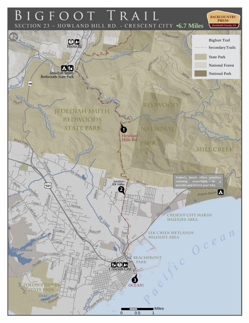
Endert’s Beach offers primitive camping, oceanfront, as a possible way to end your hike.
National Forest
National Park
Bigfoot Trail
Secondary Trails
State Park
Section 23 | Howland Hills Road to Pacific Ocean 352.1 Reach Howland Hills Road, take a left, and stay on it. (0.0) 353.9 Gate at saddle, enter second growth and drop to the Crescent City bottoms (1.8) 354.5 Grand fir before leaving the forest—before and just under the State Park sign. (0.6) 355.6 Cross Elk Valley Rd., stay west on Union St. (1.1) 356.3 Look for Elk Valley Trail to 2nd St. (0.7) 356.9 Stay straight on 2nd St. (0.6) 357.0 Right on Front St. (0.15) 358.0 Left on Play St. (0.9) 358.2 Left on Stamps Way (0.2) 358.7 Right on Battery St./Howe Dr. (0.5) 358.8 Left on South A St. south to the Lighthouse (0.1) - CONGRATULATIONS! Dip your toe in the Ocean and touch the California Coastal National Monument
Suggested maps for the entire route:
• Yolla Bolly-Middle Eel Wilderness http://www.nationalforestmapstore.com/product-p/ca-47.htm • Shasta Trinity National Forest http://www.nationalforestmapstore.com/product-p/ca-14.htm • Trinity Alps Wilderness http://www.nationalforestmapstore.com/product-p/ca-46.htm • Klamath National Forest http://www.nationalforestmapstore.com/product-p/ca-76.htm • Marble Mountain and Russian Wilderness http://www.nationalforestmapstore.com/product-p/ca-36.htm • Red Buttes Wilderness http://www.nationalforestmapstore.com/product-p/or-20.htm • Siskiyou Wilderness http://www.nationalforestmapstore.com/product-p/ca-71.htm • Six Rivers National Forest http://www.nationalforestmapstore.com/product-p/ca-16a.htm
ISBN 978-1-941624-04-3 • use maps with care and proper wilderness preparations • www.backcountrypress.com