The Boltysh crater fill sediments – a 500,000 year record of the lower Danian I. Gilmour 1 , D.W. Jolley 2 , R.J. Daly 2 , S.P. Kelley 1 , and M.A. Gilmour 1 1. Department of Physical Sciences, The Open University, Milton Keynes MK7 6AA, UK 2. Department of Geology & Petroleum Geology, University of Aberdeen, Aberdeen AB9 2UE, UK
Transcript
The Boltysh crater fill sediments – a 500,000 year record of the lower Danian
I. Gilmour1, D.W. Jolley2, R.J. Daly2, S.P. Kelley1, and M.A. Gilmour1
1. Department of Physical Sciences, The Open University, Milton Keynes MK7 6AA, UK 2. Department of Geology & Petroleum Geology, University of Aberdeen, Aberdeen AB9 2UE, UK
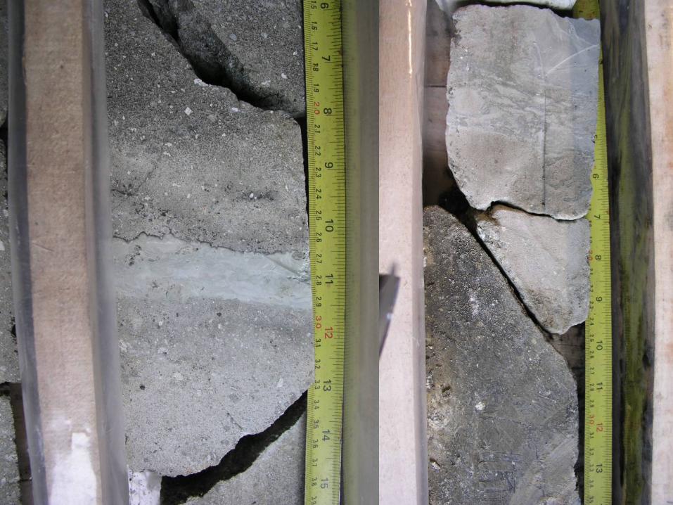
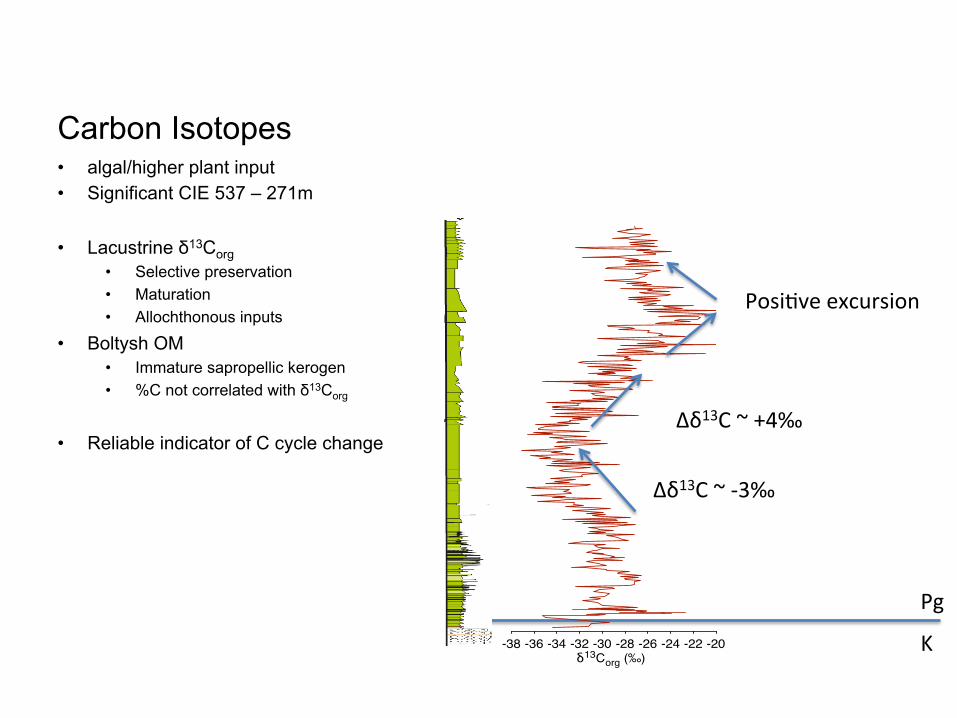
The Boltysh crater lacustrine sediments accumulated in around 600m of accommodation space on the Ukrainian shield. The continuity of this accommodation space post-impact would have ensured a continuous record of deposition without the intervals of non-deposition inherent in fluvio-deltaic depositional settings.
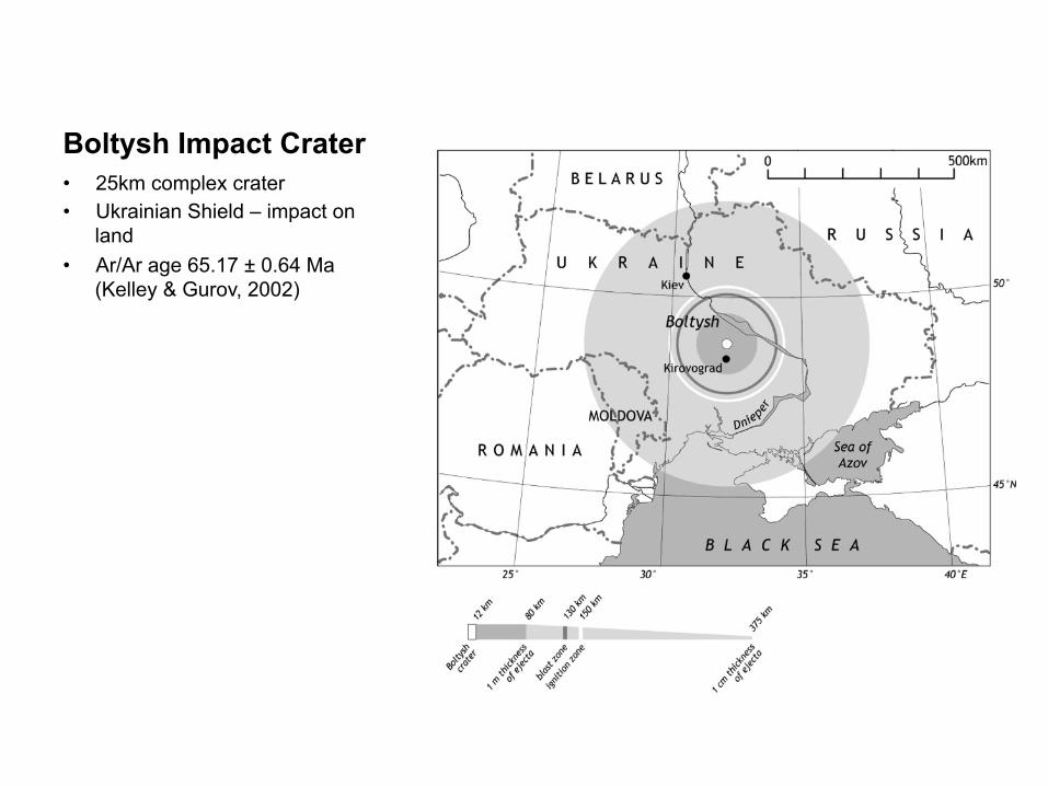
(Kelley & Gurov, 2002) • Drilled in the 1960s & 70s
• Cores lost
• 500m crater-fill sediments
• Paleogeography
stones with clastic materials occur in the UpperMaastrichtian (50^80 m). It contains rich assem-blages of macrofossils : ammonites Hoploscaphitesconstrictus constrictus (J. Sowerby), H. constrictuscrassus (Lopuski); belemnites Neobelemnella kazi-miroviensis (Skolozdrowna); echinids Cyclaster in-teger Seunes, Echinocorys ciplyensis Lambert,Echinocorys arnaudi Seunes, Echinocorys meudo-nensis Lambert, Echinocorys pyramidata Portlock,Gauthieria radiata broecki Lambert and Salenidiapygmea (von Hagenow). The Upper Maastricht-ian chalk contains very rich assemblages ofbenthic foraminifera. On the basis of their distri-bution the Brotzenella praeacuta Zone (BF12) inthe lower part and Hanzawaia ekblomi Zone
(BF13) in the upper part of the succession wererecognised (Naidin et al., 1984; Beniamovskiiand Kopaevich, 1998; Kopaevich and Benia-movskii, 1999). Planktonic foraminifera assem-blages in the Upper Maastrichtian of Mangyshlakshow a low diversity. However, the presence ofsome zonal species allows to recognise the upperpart of Globotruncanita stuarti Zone and Pseudo-textularia elegans ( = deformis) Zone (Kopaevichand Beniamovskii, 1999). Calcareous nannofossilsinclude Nephrolithus frequens (Gorka), the markerspecies for the Upper Maastrichtian in high lati-tudes (Herman et al., 1988; Naidin et al., 1990;Kopaevich and Beniamovskii, 1999).
Fig. 12. Scheme of the development of the sea/continental conditions in the North-Eastern Peri-Tethys during the Cretaceous(after Baraboshkin, 1997c, changed and completed).
However, a model was also run without a crater lake to defineits role in hydrothermal activity.
5. Results5.1. Hydrothermal System Mechanics and Lifetimes
5.1.1. The 30-km Crater[35] Results of the numerical simulation of a hydrother-
mal system in a 30-km crater are shown in Figure 3.Overall, this system is driven by a central hot spot, whichheats up water and causes it to rise, generating a single largeupwelling that persists throughout the system’s lifetime. At25 years the system is primarily characterized by a largeregion within the crater’s central peak where temperaturesand pressures are compatible with water’s gaseous phase.
This results in emission of large quantities of steam up tothree kilometers (horizontally) from the center of the crater.Water is drawn toward the crater’s center to replenish theescaping steam. While not modeled explicitly due to thelimitations of the code, this phase transition would have leftbehind minerals and caused a degree of clogging in thisregion. However, subsequent flow of hot water through thecentral peak may have redissolved these minerals. Thesource and sink of the water is the crater lake; virtuallyno water is drawn from the permeable right boundary afterthe formation of the crater lake.[36] By 1,000 years, the steam emission from the central
peak has essentially ceased. While there are still smallquantities of steam being generated within the central peak,it condenses before reaching the surface. The temperatures
Figure 3. Results of a numerical simulation of the hydrothermal system at a 30-km crater on earlyMars. The central peak of the crater is on the left side of each figure. Surface permeability k0 is 10
!2 darcies.Solid arrows and dotted arrows indicate the water and steam fluxes, respectively. The lack of arrows in someregions indicates that fluxes are less than 2 orders of magnitude smaller than the maximum flux. Solid linesare isotherms, labeled in degrees Celsius. The length of the arrows scales logarithmically with the fluxmagnitude, and the maximum value changes with each plot. (a) 25 years, max. water flux = 6.66 "10!5 kg s!1 m!2, max. steam flux = 1.84 " 10!5 kg s!1 m!2; (b) 1,000 years, max. water flux =1.50 " 10!5 kg s!1 m!2, max. steam flux = 2.33 " 10!7 kg s!1 m!2; (c) 10,000 years, max. waterflux = 6.01 " 10!6 kg s!1 m!2; (d) 100,000 years, max. water flux = 8.49 " 10!7 kg s!1 m!2.
E12S09 ABRAMOVAND KRING: HYDROTHERMAL ACTIVITY ON EARLY MARS
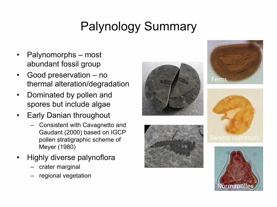
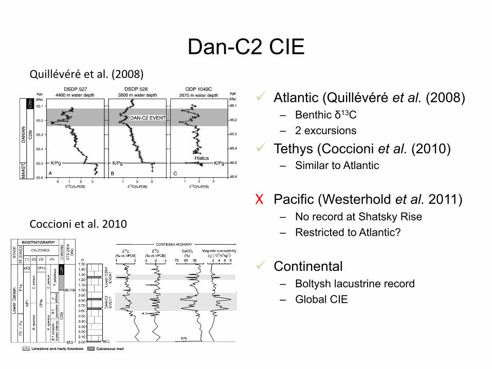
! Tethys (Coccioni et al. (2010) – Similar to Atlantic
X Pacific (Westerhold et al. 2011) – No record at Shatsky Rise – Restricted to Atlantic?
! Continental – Boltysh lacustrine record – Global CIE
Quillévére et al. (2008)
Fig. 2. Changes in δ13C and δ18O of bulk sediments, CaCO3 content, and magnetic susceptibility (χ) in the lowermost Danian at Contessa Highway, plotted with changes in δ13C and δ18O of bulk sediments, CaCO3 content, and magneticsusceptibility from the equivalent stratigraphic interval at ODP Hole 1049C (Black Nose, NW Atlantic) and DSDP Holes 527 and 528 (Walvis Ridge, SE Atlantic), where the Dan-C2 event was first recognized by Quillévéré et al. (2008). Reliablecorrelation of these changes among locations shows the occurrence of the Dan-C2 event, here represented by the lower gray shaded area, at Contessa Highway. The upper gray shaded area marks the “Lower C29n” event. The newbiostratigraphy of the early Danian at Contessa Highway is based on the planktonic foraminiferal (PF) Zones of Berggren and Pearson (2005) and calcareous nannoplankton (CN) Zones of Martini (1971) (1), Romein (1979) (2), Okada andBukry (1980) (3), and Perch-Nielsen (1985) (4). Magnetostratigraphy is from Lowrie et al. (1982). BCL: K–Pg boundary clay layer. Stage and numerical ages (GTS, Geological Time Scale 2004) are from Gradstein et al. (2004).
300R.Coccioniet
al./Earth
andPlanetary
ScienceLetters
297(2010)
298–305
Coccioni et al. 2010
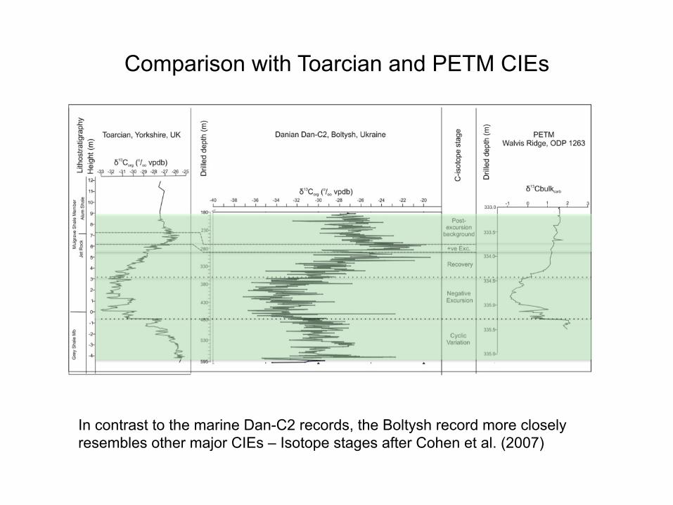
Comparison with Toarcian and PETM CIEs
In contrast to the marine Dan-C2 records, the Boltysh record more closely resembles other major CIEs – Isotope stages after Cohen et al. (2007)
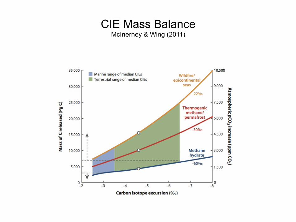
CIE Mass Balance McInerney & Wing (2011)
1. Introduction
Continental flood basalt provinces are laterallyextensive lava accumulations of substantial thicknessand low topographic relief (Rampino and Stothers,1988). India’s dominantly tholeiitic Deccan Trapflood basalt province presently extends across approx-imately one sixth of the subcontinent, encompassingup to 106 km2 of its western portion (Deshmukh,1982; Fig. 1). The basalts include Traps downfaultedinto the Arabian Sea west of Mumbai (Bombay) andforming part of the Seychelles microcontinent (Tan-don, 2002; Devey and Stephens, 1991), and possiblyoriginally occupied a volume of up to 106 km3 prior totheir erosion (Courtillot et al., 1986).
The duration of the whole Deccan volcanic episoderemains a polemic issue, and advocates exist for botha brief (b1 m.yrs., e.g., Duncan and Pyle, 1988;Hofmann et al., 2000) and extended (e.g., Widdowsonet al., 2000; Sheth et al., 2001a) period of activity.This theme is particularly pertinent when assessingthe effects of flood basalt volcanism upon local,regional and even global ecosystems. A rapid
emplacement of an entire flood basalt province wouldtheoretically prove more detrimental than a series ofevents separated by protracted dormant intermissions.Proof of quiescent phases exists in the form ofsedimentary sequences that accrued between theTraps. Subsequent extrusives often preserved thesebintertrappeansQ, and evidence can be sought withinthem regarding the influence of volcanism uponsedimentary systems, microclimates and biota.
Because substances released during mafic erup-tions are less likely to reach potentially damagingstratospheric levels than those expelled by felsicvolcanism, the effects of late stage, increasinglyfelsic, explosive Mumbai volcanism are of interest.Controversially, a study of massive, well-constrainedpyroclastic events (Erwin and Vogel, 1992) foundthat these did not reduce the ecological diversities ofland and marine ecosystems on regional or globalscales, and hence were unlikely to be responsible formass extinctions. A bolide impacting Mexico’sChicxulub platform (Hildebrand et al., 1991) isbroadly accepted to have exacerbated, if not singu-larly forced, end Maastrichtian extinctions across the
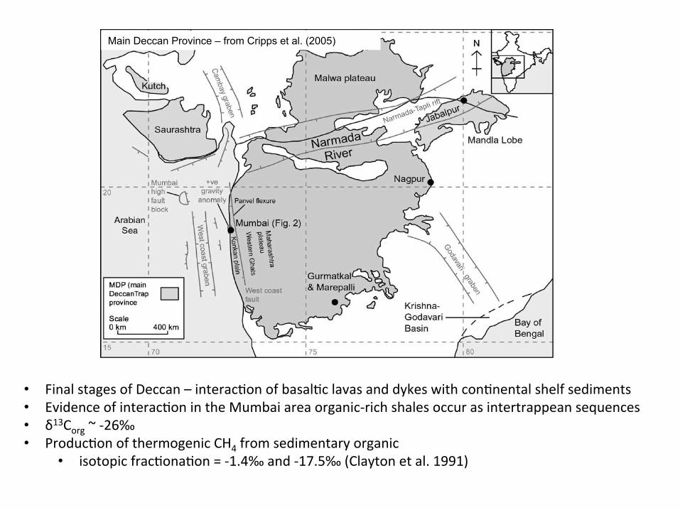
Fig. 1. Present-day Deccan Trap outcrop extent. Major tectonic structures redrawn from Biswas (1991).
J.A. Cripps et al. / Palaeogeography, Palaeoclimatology, Palaeoecology 216 (2005) 303–332304
Main Deccan Province – from Cripps et al. (2005)
• Final stages of Deccan – interac(on of basal(c lavas and dykes with con(nental shelf sediments • Evidence of interac(on in the Mumbai area organic-‐rich shales occur as intertrappean sequences • δ13Corg ~ -‐26‰ • Produc(on of thermogenic CH4 from sedimentary organic
• isotopic frac(ona(on = -‐1.4‰ and -‐17.5‰ (Clayton et al. 1991)
5.2. Aureole thickness
We show that the existing “rule of thumb” predictingaureole thicknesses of about 100% of the sill thicknesscan be improved to involve the temperatures of host-rockand intrusion, in addition to the sill thickness (Eq. (13)).The non-linear response of aureole thickness to sill thick-ness also implies that no universal 1:1 relationship can beexpected, as thicker sills will have relatively thicker normal-ized aureoles. This is due to a longer total time for the heatpulse to pass through the rocks in the case of thicker sills.The derived relationship is consistent with a large diversity
in the data (Fig. 6a and b), and is further supported by avitrinite data showing a relation between the logarithm ofintrusion thickness and the aureole thickness (Raymondand Murchison, 1988). The calculated relationship is lessaccurate for a combination of extreme values in tempera-tures and sill thickness, such as a 1 m sill with T m of900 !C and T hr of 10 !C.
An important implication of the relationship in Eq. (13)is that we expect larger aureoles to occur when sills intrudeinto host-rocks of relatively high background temperatures,as long as the temperature is within the field of normal or-ganic maturation. Thus, thicker aureoles will develop in ba-sins with high geothermal gradients or around deeplyemplaced sills. This is illustrated in Fig. 10a using Eq.(13) showing aureole thicknesses as a function of differentgeothermal gradients. The figure is calculated using a sillthickness of 50 m and a constant intrusion temperature of1150 !C. Fig. 10b illustrates how sill thicknesses influencethe aureole thicknesses with depth. The geothermal gradi-ent is fixed at 20 !C/km, with a constant intrusion temper-ature of 1150 !C. In a volcanic basin, multiple sill intrusionscan cause larger aureoles due to elevated background tem-peratures (Hanson and Barton, 1989; Deyoreo et al., 1991;Aarnes et al., in review-b).
5.3. Composition and fate of fluids
Contact aureoles in shales will be dominated by CH4–H2O fluids rather than H2O–CO2 fluids, because of lowoxygen fugacity resulting from a lack of oxygen sources(Connolly and Cesare, 1993). This fits well with ourassumption of kerogen converting mainly into CH4, ratherthan CO2. At 100 MPa the solubility of CH4 in H2O is 0.4–10 wt.% for the temperature range 100–350 oC (Bonham,1978). This implies that for an aureole with 5 wt.% TOC,
Fig. 8. (a) Fluid speciation phase diagram calculated from Perple_X for a carbon saturated system, using the equation of state from Connollyand Cesare (1993) contoured for pressures ranging from 100 to 500 MPa. For 1 wt.% TOC there will be miscibility between water andmethane at !375 !C, while fluids in rocks of 5 wt.% TOC are miscible at !275 !C, for thermodynamic pressures of 100–200 MPa. (b)Calculated densities of the fluid(s) at 100 MPa. At this pressure the CH4-dominated phase will have a relatively low density of !200 kg/m3,while the H2O-dominated phase will have a relatively much higher density of !900 kg/m3.
tota
l Kar
oo B
asin
west
ern
Karo
o Ba
sin
wt%
TOC
Area intruded by 100 m thick sill [km2]
Gen
erat
ion
pote
ntia
l CH
4 [G
t]35 000
30 000
25 000
20 000
15 000
10 000
5 000
50 000 250 000 350 000150 000
10
9
8
7
6
5
4
3
2
1
Vørin
g an
d M
øre
Basi
ns
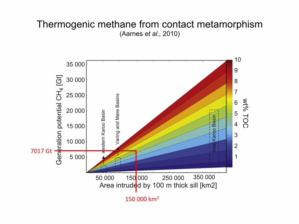
Fig. 9. Calculated total methane potential in gigatons, (Gt) as afunction of area covered by a cumulative intrusion thickness of100 m continuous sill. The generation potentials are for the westernKaroo Basin (50,000 km2) !400–2100 Gt CH4, the Vøring andMøre basins (85,000 km2) !600–3500 Gt CH4 and the total KarooBasin (390,000 km2) !2700–16,200 Gt CH4, for values of reactedshales from 1 to 6 wt.% TOC.
Gas generation around igneous sills 7189
7017 Gt
150 000 km2
Thermogenic methane from contact metamorphism (Aarnes et al., 2010)
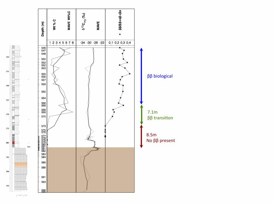
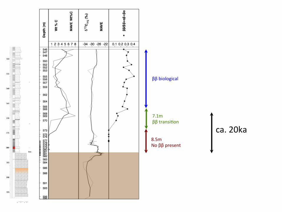
Summary – Boltysh Crater fill sediments
• 24km diameter Boltysh Impact Crater in Ukraine – Lacustrine crater fill sequence of fine grained organic carbon-rich sediments – Preserve a uniquely complete and detailed negative carbon isotope excursion (CIE) in
an expanded section of several hundred metres. • Position of CIE in the early Danian, ca. 200ka above K/Pg
– Correlates with Dan-C2 CIE in marine record – Early Danian Hyperthermal Event
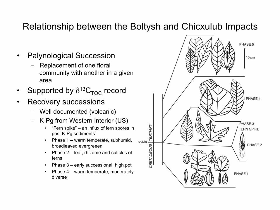
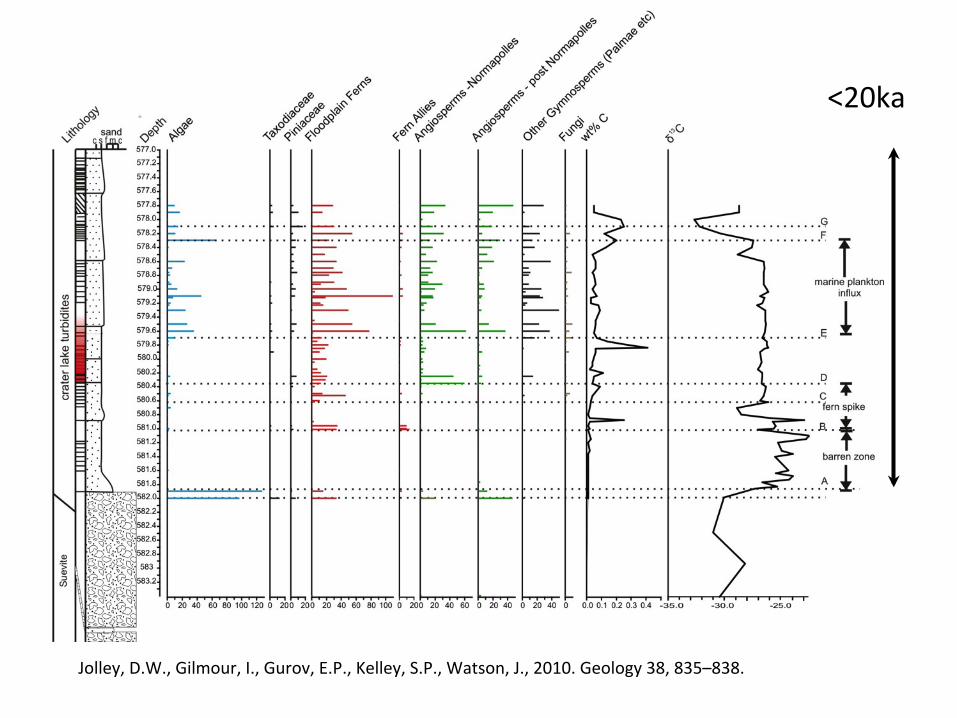
• Changes in floral communities through the CIE reflect changing biomes caused by rapidly warming climate, followed by recovery
– EDH event had a similar duration to the Toarcian and Paleocene/Eocene events • Temporal correlation EDH event with late stages of Deccan Continental
Flood basalt province, and initiation of rifting – Deccan province: cause of global warming and the carbon-isotope excursion
• A high resolution record that is potentially resolving the effect of Chicxulub from the effects of Deccan
• High resolution/stratigraphically complete records have implications…