40
STRATEGIC RECOVERY PLANNING REPORT Draft : March 2016 THE BOROUGH OF EDGEWATER

STRATEGIC RECOVERY PLANNING REPORT
Draft : March 2016
THE BOROUGH OF EDGEWATER

ACKNOWLEDGMENTS
Planning Board Professionals
Craig P. Bossong, Board Attorney
John Candelmo, Land Use Administrator
CME Associates, Borough Engineer
Kathryn Gregory: Gregory Associates, Planner
Planning Board
Kevin O’Connor, Chairman
Kathleen D’Errico, Secretary
Robert Bournias, Member
John Candelmo, Member
Howard Levine, Member
Pete Philomey, Member
Ema Kelly, Member
Robert Christiansen, Alternate
Julia Park, Alternate
Anthony Bartolomeo, Council Liaison
Mayor Michael McPartland
Council Members
Anthony Bartolomeo
Michael Henwood
Duane Fischetti
Dolores Lawlor
Vincent Monte
Jose Luis Vidal

Prepared By:
Elizabeth K. McManus, AICP, LEED APPP License #5915
Courtney Lewis, Planner
STRATEGIC RECOVERY PLANNING REPORT
BOROUGH OF EDGEWATER, BERGEN COUNTY, NEW JERSEY
Clarke Caton Hintz
Architecture
Planning
Landscape Architecture


CONTENTS1. Superstorm Sandy .................................................................... 1
2. Existing Conditions ..................................................................2
3. Damage From Superstorm Sandy ........................................5
4. Vulnerabilities & Opportunities Highlighted by Superstorm Sandy ....................................................................7
5. Policy Review ........................................................................... 12
6. Action Steps To Date .............................................................16
7. Recommended Action Steps ..............................................20

1
STRATEGIC RECOVERY PLANNING REPORT | BOROUGH OF EDGEWATER, BERGEN COUNTY, NEW JERSEY
Superstorm Sandy was the deadliest hurricane of the 2012 Atlantic Hurricane season and one of the costliest storms to impact the United States. It made landfall on October 29, 2012 along the southern coast of New Jersey near Atlantic City. Fortunately, it was downgraded to a post-tropical cyclone with hurricane force winds prior to landfall. Even with the downgraded status, the damage in New Jersey was unprecedented with approximately 346,000 New Jersey homes damaged, of which 22,000 were uninhabitable and nearly 19,000 businesses sus-tained damage of $250,000 or more1. Sandy also took the lives of 34 people in the State2.
Sandy hit Edgewater with winds over 76 miles per hour3 and inundated much of the Borough. At only .94 square mile of land and an extensive waterfront, nearly 38% 4 of the Borough is located in the Special Flood Hazard Area (defined as having a 1% annual chance of flooding). River Road (County Route 505) experienced several large fallen trees that took down power lines, preventing emergency and DPW vehicles from traversing the Borough north-south, essentially dividing the Borough in half. Extensive flooding occurred east of River Road and on the road itself.
In response to the storm’s impacts, the federal gov-ernment allocated more than $50 billion to 19 federal agencies as part of the Disaster Relief Appropriations act of 2013. Of that allocation, $15.2 billion was appropriat-ed for the HUD Community Development Block Grant Disaster Recovery (CDBG-DR) program and, of this, $3.3 billion was allocated for New Jersey and will be awarded in two rounds. New Jersey received $1.8 billion in the first round (2013) and $1.5 billion in the second round (2014). This Strategic Recovery Planning Report (SRPR) is pre-pared for the Borough of Edgewater with funding provid-ed by the New Jersey Department of Community Affairs through its Post Sandy Planning Assistance Grant Pro-gram. This State grant program is funded by the Federal CDBG-DR program allocation. Completion of a Strategic Recovery Planning Report is prerequisite for additional funding from the Post Sandy Planning Assistance Grant Program; subsequent applications may request funding for master planning, ordinances, capital facilities planning and similar projects.
The Borough, as well as the State and Bergen County, are conducting post-disaster planning, which is defined as creating a vision for the community’s recovery that addresses reconstruction, economic recovery and land use regulations. The immediate safety issues during and after a disaster are not addressed in this topic and are better addressed in emergency response planning. There are three broad categories which municipalities should address in their post-disaster planning:
■ Hazard Mitigation – The lessening of the potential adverse impacts of physical hazards (including those that are human-induced) through actions that reduce hazard, exposure, and vulnerability.
■ Resilience – The ability of a system and its com-ponent parts to anticipate, absorb, accommo-date or recover from the effects of a hazardous event in a timely and efficient manner, including through ensuring the preservation, restoration or improvement of its essential basic structures and functions
■ Adaptation – The process of adjustment to actual or expected climates and their effects in order to moderate harm or exploit beneficial opportunities.
This Strategic Recovery Planning Report addresses each of these categories and provides action steps for how Edgewater can perform hazard mitigation, increase its resiliency from natural disasters, and adapt to a changing climate and weather events.
SUPERSTORM SANDY

2
BOROUGH OF EDGEWATER, BERGEN COUNTY, NEW JERSEY | STRATEGIC RECOVERY PLANNING REPORT
The Borough of Edgewater is located in the southeastern portion of Bergen County and encompasses .94 acres of land. The Borough’s long and narrow configuration stretches 3.5 miles along the Hudson River and is bound-ed by the Borough of Fort Lee to the north and west, the Borough of Cliffside Park to the west, North Bergen Township to the south and the Hudson River to the east. The Hudson River Palisades form the Borough’s western boundary to Cliffside Park and Fort Lee.
Historically, development in Edgewater has been charac-terized as a residential community with commercial and industrial uses along the waterfront. However, over the years the character of the Borough has evolved from in-dustrial to more mixed-use and residential development.
Additionally, over the previous several decades the Bor-ough expanded its land area into the Hudson River with fill. This development of new uses and land area patterns is consistent with trends for the Gold Coast municipali-ties up and down the Hudson River.
The following aerial photographs from 1954 and 2013 illustrate the changes to the Borough’s waterfront over approximately the last 60 years.
EXISTING FLOOD HAZARD AREAS
Parts of the Borough flood approximately once a month
5.Flooding in the Borough can be extensive given that 38% of Borough land is within the Special Flood Hazard Area, which is defined as having a 1% annual chance of flooding, and an additional 10% of land is within the Moderate Flood Hazard Area, which has a 0.2% annual chance of flooding. Base flood elevations (BFE) in the Bor-ough range between 10 feet and 15 feet .These figures are sourced from the 2014 FEMA Preliminary FIRM maps 6.
Nearly all of the non-coastal flooding that occurs in the Borough is generated from outside its boundaries. Runoff from communities to the west on the other side of the Palisades flow into Edgewater. Preliminary FEMA flood maps place most of the Borough’s land east of River Road and south of North Street is in the Special Flood Hazard Area or Moderate Flood Hazard Area. Some properties
EXISTING CONDITIONS
Southern portion of the Borough surrounding the inter-section of River Road and George Road,2013
Southern portion of the Borough surrounding the inter-section of River Road and George Road, 1954
Northern portion of the Borough surrounding Veteran’s Field, 2013
Northern portion of the Borough surrounding Veteran’s Field, 1954

3
STRATEGIC RECOVERY PLANNING REPORT | BOROUGH OF EDGEWATER, BERGEN COUNTY, NEW JERSEY
on the western frontage of River Road in the central part of the Borough are also in these zones.
The areas with BFEs between 14 feet and 17 feet are mostly open space (walkways, docks, and parking lots) along the water. Portions of the residential properties on east side of Shore Road north of Colony Drive have BFEs between 19 feet and 21 feet. While most of the area with a BFE over 18 feet only applies to open space, it does cover portions of several residential properties 7.
As of February 2014, the Borough had $2,314,879.60 in total FEMA payments for repetitive loss properties with an average payment of $165,348.54 covering four proper-ties and 14 losses. A repetitive loss property is defined as any NFIP-insured building with at least two claims of over $1,000 in a ten year period since 1978.8
There are two severe repetitive loss (SRL) properties, which are summarily defined as any NFIP-insured resi-dential property that has met at least 1 of the following paid flood loss criteria since 1978: 1) four or more sepa-rate claim payments of more than $5,000 each (includ-ing building and contents payments); or 2) two or more separate claim payments (building payments only) where the total of the payments exceeds the current value of the property. The two SRL properties had $2,226,152.81 in total FEMA payments with an average payment of $222,615.28 covering ten losses.9
ROAD FLOODING
Edgewater floods regularly during heavy rain storms and the flood source, communities west of the Palisades, are outside of the Borough’s boundaries. From 2013 through 2015, the Edgewater Police Department received 38 reports of road flooding. The only access points to the Borough from the west over the Palisades are State Route 5, Edgewater Road, and Gorge Road. There is no County evacuation route in the Borough and the closest routes are the New Jersey Turnpike to the north and Route 46 to the west.
The overwhelming majority of the flood events, 25 (66%), occurred at 880 River Road, which is the location of an outfall to the Hudson River that commonly backs up and overflows. Heavy rain storms often result in the clo-sure of one or more lanes along River Road. Appendix A contains a table of all of the road flooding events reported to the Edgewater Police Department from 10/29/2012 (the date Sandy hit) to 8/11/2015.10
FLOOD CONTROL STRATEGY & STORMWATER INFRASTRUCTURE
Edgewater operates four water pumping stations, three of which have generators. There is also an outfall to the Hudson River at the 880 River Road commercial build-ing. The outfall commonly backs up and floods the site’s parking lot and that area of River Road. There is currently a study examining the feasibility of raising the outfall to prevent water backups.11
PUBLIC WATER AND SERVICE UTILITIES
The Borough’s potable water supply is provided by United Water. Bergen County owns and operates the collection system of sanitary sewers in Edgewater.12 PSE&G provides electricity.13 Storms frequently affect PSE&G’s infrastruc-ture in the area and cause power outages in Edgewater.14
EVACUATION ROUTES
Edgewater’s evacuation routes comprise its only east-west streets that cross the Palisades: Edgewater Road, Gorge Road, and Route 5. 15 There are no County evacua-tion routes in Edgewater.16
EMERGENCY ALERT
The Borough implemented its Reverse-911 system in 2011. There are currently a combined 5,453 phone numbers (landline and mobile) and email addresses in the sys-tem.17 While it is not known how many households have more than one phone number registered to the system, this should be compared to the 6,156 households identi-fied in the 2013 American Community Survey.


5
BOROUGH OF EDGEWATER, BERGEN COUNTY, NEW JERSEY | STRATEGIC RECOVERY PLANNING REPORT
DAMAGE FROM SUPERSTORM SANDY
Damaged Structures Reported to the Borough or That Required a Building Permit 25,26
Type Residential Non-Residential
Total 75 15
Flooding 72 8
Wind 7 4
Boat 0 2
Landscaping 0 2
Other 1 0
Vehicles* 6 0
*Count of private properties with flooded vehicles,not the total number of vehicles flooded
Superstorm Sandy made landfall with 80 mph winds and record-breaking low pressure. If Sandy was a hurricane at landfall, it would have been a Category 1 storm. The storm hit New Jersey during an exceptional high tide and caused extensive flooding along the Hudson River and in Edgewater, with some areas in the Borough flooded with six feet of water.18
Of the Borough’s 6,156 homes reported in the 2013 American Community Survey, at least 75 residential units (1.2%), as well as at least 15 nonresidential structures, sustained damage from flooding, wind and/or fallen trees. Approximately 73 homes experienced flood damage19,20 and no homes were substantially damaged, defined as damage that exceeds 50% of the home’s market value.21
While many residences east of River Road flooded, some with four to six feet of water,22 because the majority of units have parking on the first floor, water did not reach their living spaces.23 In addition, floods damaged approx-imately 60 vehicles.24 The table below details the type of
damage by structure type. Detailed information about the damage at each location can be found in Appendix B.
No buildings have been elevated, demolished, or rebuilt as a result of Sandy. One of Edgewater’s private marinas had such significant flooding that it permanently closed. After the storm, the building department issued 65 repair permits, 60 of which were for water and electrical system damage at Shelter Bay condominiums, four for water damage at homes at the Edgewater Colony, and one for water and electrical system damage at the apartment building at 980 River Road.
Despite the Borough’s history as a manufacturing community and the Transcontinental Gas Pipeline that runs through Edgewater, the Borough had no hazardous materials or natural gas spills or leakages during or after the storm.27 It was reported that, overall, Edgewater suf-fered approximately $400 million in private and over $2.5 million in public property damage.28
In addition to flooding, much of the Borough experienced significant power outages, with most of Edgewater without power for one week and some areas for up to two weeks.29 The entire community remained without power five days after the storm30. Even though Superstorm Sandy toppled several large trees, the Borough continues to frequently loses power when storms affect PSE&G infrastructure in the area. PSE&G power feeds originate in two locations outside of the municipality.31
Numerous municipal structures suffered flood damage during Sandy, including the DPW shop and garage, EMS building, Marina and pool. The Community Center, DPW maintenance building, and Hudson River Waterfront Walkway suffered other damage.32
At the time Sandy hit Edgewater, a contractor was reme-diating contamination at Veterans Park. Sandy uprooted several large trees and damaged fences, utility poles, and power lines in the park. In addition, soil on the south-western section of the park settled so significantly that a

6
STRATEGIC RECOVERY PLANNING REPORT | BOROUGH OF EDGEWATER, BERGEN COUNTY, NEW JERSEY
contractor’s excavator sank approximately eight feet, the parking lot flooded, a retaining wall shifted, and pipes and drains buckled.
Recommended improvements post-Sandy included elevating portions of the park such as pedestrian paths above the base flood elevation and submitting repair re-imbursement requests to FEMA that were initially denied by administering insurance agencies.33 As of March 2013, the Borough still needed to repair sidewalks and fencing along River Road and remove and reset approximately 1,000 ft. of the retaining wall. In October 2013, repairs to the park were suspended as tests found additional contaminants, purportedly introduced by the contractor conducting the remediation and repairs.34 The Borough Council appointed a new contractor to conduct the work.35

7
BOROUGH OF EDGEWATER, BERGEN COUNTY, NEW JERSEY | STRATEGIC RECOVERY PLANNING REPORT
VULNERABILITIES & OPPORTUNITIES HIGHLIGHTED BY SUPERSTORM SANDY
Critical Facilities
Facility Address
DPW 540 River Road
DPW Annex 1165 River Road
Community Center 1167 River Road
Library 49 Hudson Avenue
Municipal Building/ Police Department
55 River Road
Historic Borough Hall 916 River Road
Fire Company #1 1408 River Road
Volunteer First Aid Squad 915 River Road
Post Office 770 River Road
Fire Headquarters 838 River Road
Eleanor Van Gelder School 251 Undercliff Avenue
George Washington School
801 Undercliff Avenue
Bergen County Utilities Authority
520 River Road
Pump Station #1 1385 River Road
Pump Station #2 915 River Road
Pump Station #3 281 Old River Road
Pump Station #4 135 Old River Road
There were few opportunities highlighted by Superstorm Sandy, but it did create the chance to evaluate the flood control infrastructure and to renew advancement of pro-posals for flood protection.
LACK OF FLOOD CAPACITY
The Borough is nearly fully developed with only one large public waterfront space, Veterans Field, and that could be used for flood storage capacity. State acquisition of flood-prone land through the Blue Acres Program has focused on large areas that can make a significant contribution toward flood storage. As such, the Borough does not have the opportunity to develop flood storage without the acquisition of privately-owned and developed land or a community asset (once remediated) and subsequent conversion to open space. Doing so would not only be a very costly process but would erode the Borough’s tax base since the majority of high-value homes and non-res-idential uses are in this area.
FLOOD & STORMWATER INFRASTRUCTURE
None of Edgewater’s four pump stations flooded, but Pump #4 lost power during Sandy and subsequently stopped operating. The Borough will install a generator at this location.36
CRITICAL FACILITIES
Edgewater has 17 public critical facilities.37Of these 17 fa-cilities, the 2015 County Hazard Mitigation Plan identified ten as vulnerable to flooding. In addition, one facility, the Bergen County Utilities Authority facility, is vulnerable to storm surges.38 The adjacent table identifies each public facility and its location.
Fallen trees during Sandy rendered staff at the DPW building, located in the southern half of Edgewater on River Road, unable to reach northern parts of the Borough

8
STRATEGIC RECOVERY PLANNING REPORT | BOROUGH OF EDGEWATER, BERGEN COUNTY, NEW JERSEY
for up to ten days.39 During Sandy, the police and fire department were temporarily unable to respond to calls because of downed power lines and flooding.40
The majority of the Borough’s critical facilities are lo-cated within the Special Flood Hazard Area because of Edgewater’s topography, its long and narrow shape, and River Road being its primary thoroughfare. See the Flood Zones/Critical Facilities map in this report for the loca-tions of critical facilities in the Borough. The location of the Borough’s critical facilities in the Special Flood Hazard Area and Edgewater’s geographic constraints led to not only necessary repairs subsequent to Sandy, but also difficulties in conducting emergency operations during and after the storm.
The Borough should raise generators at its municipal facilities at a minimum above the base flood elevation. Reliable generators will support emergency service and municipal personnel, as well as displaced residents, during flood events when a loss of power has also oc-curred. Location out of flood prone areas, or at a mini-mum above the base flood elevation, should be priorities for any new municipal facilities.
LIMITED EVACUATION OPTIONS
As highlighted during Sandy, Edgewater’s remote location underneath the Palisades and adjacent to the Hudson River, as well as its long and narrow area, makes evac-uation and emergency response complicated. There is limited land access out of the Borough, with River Road to the north and south and Gorge Road, Edgewater Road, and Route 5 to the west. River Road floods with enough regularity, albeit briefly, to be an unreliable route during emergencies. Flooding partially or fully closed River Road approximately 35 times over the past three years. The temporary flooding and longer-term fallen trees and power lines during Sandy effectively divided the Borough in half. In addition, a downed utility pole and power lines temporarily blocked Route 5 41 and Gorge Road was only accessible to emergency vehicles.42
Roadway elevations, tree trimming, utility pole placement and evacuation routes should be studied to determine if raising the road elevations will limit or prevent roadway flooding in a way that not only prevents roadway damage and extends time for evacuation but also does so in a way that is not detrimental to community character. As such, the evaluation should include flood elevation, evacuation routes, land uses, and the setback of buildings to the roadway.
Additionally, emergency personnel evacuated the Com-fort Inn and Sunrise Assisted Living Facility on River Road after both declined to voluntarily evacuate before the storm.43 The Borough should work with these facilities and similar ones in the SFHA to better prepare visitors and residents for major flood events.
DEMOGRAPHICS AND COMMUNICATION
Power for volunteer emergency personnels’ pagers failed, leaving the Borough unable to call them to a response. Consequently, the Borough decided to keep all emergen-cy personnel on site at the main fire station and first aid building for ten days.44
The Borough did not experience any significant chal-lenges during or after Superstorm Sandy related to the Borough’s population demographics, including those re-lated to age, income or non-English speaking residents.45 This should be considered in light of the fact that 35% of the Borough’s population is of Asian, primarily Korean, decent.46
When residents told the Borough that it was difficult to receive information via electronic devices because they could not reliably charge them, fire trucks began travers-ing the area and making announcements through loud speakers.47
Edgewater’s Reverse 911 system, implemented in 2011, was new enough at the time Sandy hit that there was not significant participation in the program. The Borough sent approximately fifty messages during the immediate recovery period. Greater participation in the Reverse 911 system, or a more effective alternative, would allow res-idents to better prepare for flooding and evacuate safely when necessary. Since Sandy, it purchased two electronic information boards.48
SHELTER
The Bergen County Office of Emergency Management coordinates regional resources and had full service shelters and transportation to them during Sandy.49 The Borough Community Center served as the Borough’s daytime (and eventually overnight) shelter and warming/charging station. The center, which had a generator, pro-vided coffee and food, including a pasta dinner and pizza from an operating pizza shop in Fort Lee. Unfortunately, many residents could not access the Community Center, at least temporarily, because of flooded roads.50

9
BOROUGH OF EDGEWATER, BERGEN COUNTY, NEW JERSEY | STRATEGIC RECOVERY PLANNING REPORT
FUEL
With gasoline supplies especially scarce for residents after the storm, the Borough resourcefully used its ferry shuttles to transport residents to the Community Center and the former Pathmark supermarket, both of which operated with generators. Edgewater also secured some gasoline from Hess and a local Exxon station. The Exxon later opened for customers with a Borough-supplied generator.51 A local resident who owns an oil company provided generator fuel (a natural gas/diesel combina-tion).52
POPULATION AND ECONOMIC ACTIVITY AT RISK
The 2015 Bergen County Multi-Jurisdictional All-Haz-ards Mitigation Plan cites a 2007 New Jersey Hurricane Evacuation Study 53 indicating that approximately 1,737 (30.5% of the Borough’s 2007 housing stock) housing units are vulnerable to tidal flooding from a Category 1 hurricane, 1,837 (32.2% of the Borough’s 2007 housing stock) units are vulnerable to tidal flooding from a Cat-egory 2 hurricane, 2,019 units (35.4% of the Borough’s 2007 housing stock) are vulnerable to tidal flooding from a Category 3 Hurricane, and 2,116 (37.1% of the Bor-ough’s 2007 housing stock) units are vulnerable to tidal flooding from a Category 4 hurricane.54 As Edgewater has seen continued housing growth along its waterfront since 2007, it is likely that the number and percent of the Borough’s housing units vulnerable to tidal flooding from hurricanes has increased.
CHANGE IN VALUE
The Borough experienced a .92% increase in property values between 2012 and 2013 and a 1.25% increase be-tween 2013 and 2014, as measured by the total assessed value of land in Edgewater.55 The change incorporates not only the damage that occurred from Superstorm Sandy, but also some of the investment necessary for full recov-ery and broader economic growth along New Jersey’s Gold Coast. Edgewater was quite fortunate that Sandy had no impact on overall property values, especially con-sidering that 38% of Borough lands are within the Special Flood Hazard Area.
SEA LEVEL RISE
Planning for the future should consider sea level rise. Doing so leads to policies and improvements that will guide development out of harm’s way not only now but in
the future and will ensure that policies remain relevant for decades to come. The Predicted Impacts of Sea Level Rise In 2050 and Potential Future Sea Level Rise In 2100 maps on the following pages depict changes to the Special Flood Hazard Areas and the base flood elevation in 2050 and 2100 under four sea level rise scenarios.
Rising sea levels will exacerbate the risks to the Borough’s population and economic activity from flooding. Global sea levels rose an average rate of 0.6 inches per decade during the 20th century with the average rate increasing to 1.2 inches per decade since the 1990’s.56 Since 1870, global sea levels have risen about 8 inches.57 While rates of sea level rise have been and will continue to vary glob-ally; those along the New Jersey coast have risen faster than the global average due to land subsidence. Atlantic City, for example, has seen a sea level rise of 1.5 inches per decade since the earliest record keeping in 1912.58 Global sea levels are projected to increase between .85 feet and 2.95 feet above the 2005 sea level by 2100.59 While conditions in Atlantic City are different than those in Edgewater, the example illustrates the varying nature of global sea level rise and the particular impact to the New Jersey coast. It further indicates that storm surges from the Atlantic Ocean and up the Hudson River may be exacerbated in the future.
Sea level rise will cause flooding to occur more frequently and to last for longer periods of time. In Edgewater, this means that flooding east of River Road will occur more often and for longer durations. The effects of sea level rise on Edgewater will not be uniform across the Borough but will vary by topography, with properties at the lowest elevations and closest to the Hudson River serving as a water collection points and experiencing the largest impacts.
The National Oceanic and Atmospheric Administration collaborated with scientists, FEMA, the Army Corps of Engineers, United States Global Change Research Program, and White House Council on Environmental Quality to produce maps of four scenarios of sea-level rise by 2050 and 2100 using FEMA’s special flood hazard data. These four scenarios are categorized as Lowest, Intermediate-Low, Intermediate-High and Highest and each is expressed as an increase in the sea levels. The scenarios are global estimates that do not account for municipal or region specific ocean dynamics or vertical land movement.

10
STRATEGIC RECOVERY PLANNING REPORT | BOROUGH OF EDGEWATER, BERGEN COUNTY, NEW JERSEY
The best case scenario (“Lowest”) anticipates that sea levels will rise by 0.3 feet by 2050 and 0.7 feet by 2100, while the worst case scenario (“Highest”) anticipates that sea levels will rise by 2 feet by 2050 and 6.6 feet by 2100.60
Sea-level rise increases the frequency, duration, and severity of flooding. The Borough’s low-elevation makes it susceptible to flood water inundation not only during today’s rain events, but also under projected sea-level rise scenarios.
If no new protective measures are put in place, the Inter-mediate-High Scenario, which projects sea levels increas-ing by 1.3 feet by 2050 and 3.9 feet by 2100, would result in increased susceptibility to flood inundation in parts of the Borough. NJFloodmapper.com, a tool designed by NOAA and Jacques Cousteau National Estuarine Re-search Reserve, generates maps that illustrate the extent of flooding that would occur based on sea level rise mod-els ranging from 1 to 6 feet.
The tool is valuable for understanding the potential effects of sea level rise on local flooding, though the models on which it is based do not account for certain factors such as existing stormwater infrastructure and are only as accurate as the underlying data. Under the intermediate-high scenario in 2050, the Borough would not be significantly more vulnerable to flooding due to the elevations of the Hudson River banks.
As sea levels rise, so will the base flood elevation in any area with a tidally influenced water body. The Hudson River, because of its physical connection to the Atlantic
Sea Level Rise Scenarios
Scenario Scenario Basis Base Flood Elevation Change
Lowest Historic rates of observed sea level change2050: +0.3 feet
2100: +0.7 feet
Intermediate-Low Projected ocean warming2050: +0.7 feet
2100: +1.6 feet
Intermediate-High Projected ocean warming and recent ice sheet loss2050: +1.3 feet
2100: +3.9 feet
HighestOcean warming and the maximum plausible con-tribution of ice sheet loss and glacial melting
2050: +2.0 feet
2100: +6.6 feet
Ocean through Newark Bay, is tidally influenced. It should be noted that sea level rise in the table above is measured globally, and that actual changes will vary by location.
Similarly, base flood elevation is not always directly proportionate to increase in sea level rise. A coalition that includes NOAA, FEMA, US Army Corps of Engineers, and the US Global Change Research Program created a tool that projects future base flood elevations for each of these scenarios based on current and recorded historical sea level rise trends. The tool calculates projected BFEs for New Jersey based on recordings from meters at Cape May, Atlantic City, and Sandy Hook. However, given the Borough’s location, this report uses the averages of the two closest meters, at Sandy Hook, NJ and The Battery in New York City. As shown in the Sea Level Rise Scenarios table, projected increases in base flood elevation in the Borough are not always consistent or close to projected sea level rise. It should be noted that BFE is always calcu-lated to the nearest half foot.
The best case scenario for the Borough, as shown in the Lowest sea level rise scenario row of the Sea Level Rise Scenario table, is that base flood elevations will not exceed 9 feet for the next century. In the worst case scenario, however, shown in the Highest sea level rise scenario, base flood elevation will be 10.5 feet by 2050 and 15 feet by 2100.
Given the Borough’s history of flooding, and the flood risks that the Borough might face in the coming decades, it is imperative that redevelopment of the area include design elements and infrastructure to minimize the risks and impacts of flooding.


12
BOROUGH OF EDGEWATER, BERGEN COUNTY, NEW JERSEY | STRATEGIC RECOVERY PLANNING REPORT
POLICY REVIEW
The 2008 Municipal Stormwater Management Plan also addresses flood mitigation. Many of this plan’s objectives are to rely on State Residential Site Improvement Stan-dards (RSIS) for stormwater regulations.61 The Edgewa-ter’s Emergency Operations Plan does not directly relate to flood mitigation, but it recognizes that the Borough is vulnerable to relatively frequent flooding from areas west of the Palisades and the Hudson River.62 Climate adapta-tion is not addressed by the Borough.
Bergen County updated its Natural Hazard Mitigation Plan in 2015. It recognizes coastal erosion and flooding, both coastal and riverine, as some of the natural hazards facing the County and provides mitigation measures for addressing these hazards. The Plan also recognizes the effects of climate change on the County, particularly sea level rise, as exacerbating coastal flooding. In addition, hurricanes and tropical storms are identified as potential hazards, stating, “Because much of Bergen County is developed, the vulnerability is extremely high if an event were to occur.
Tropical storms and hurricanes do not need to have a direct path over Bergen County to affect the residents.”63 Superstorm Sandy validated this analysis. The Plan recognizes that the storm “highlighted the deficiencies facing many Bergen municipalities regarding disaster pre-paredness and the ability to recover from such a natural disaster” including floodwater control, flood capacity, and inadequate stormwater infrastructure.64
The 2008 Plan identified three mitigation projects65 and the 2015 Plan identifies one mitigation project66 in Edge-water to address power outages and flooding. Each proj-ect is detailed in the Recovery, Mitigation, Resilience and Adaptation Steps to Date section below. At the County level, the 2015 Plan recommends voluntarily purchasing properties particularly prone to hazards, quantifying the hazards to buildings Countywide, and evaluating and modifying its floodplain and hillside development, open space and preservation, waterfront setback, stormwater management, stream dumping, and subdivision regula-tions.67
The County Plan references the August 29, 2014 FEMA Flood Insurance Study (FIS) for Bergen County and states coastal flooding from hurricanes and nor-easters affect the entirety of Edgewater.68 This should be a concern for Edgewater as 38% of the Borough is in the Special Flood Hazard Area.
BOROUGH FLOOD AND STORM POLICIES
The following documents were reviewed for flood and storm mitigation, resiliency and emergency response: the 2014 Master Plan Reexamination Report, 2008 Municipal Stormwater Management Plan, 1990 Master Plan, Emer-gency Management Plan, and the Code of the Borough of Edgewater. The below identifies relevant Borough policies in each of these documents.
PROTECTION / CONSERVATION OF FLOOD HAZARD AREAS AND STORM DAMAGE PRONE AREAS
The 2014 Reexamination Report recommends discourag-ing development on the Palisades69 and the 1990 Master Plan advocates for protecting the Palisades, wetlands, and floodplains.70 Chapter 240-79 of the Edgewater Bor-ough Code generally prohibits structures in the 100-year floodplain.71
The Stormwater Management Plan’s goals include reducing flood damage by curtailing stormwater runoff, minimizing any impact of new development on runoff, and mitigating erosion introduced by construction or de-velopment. The Plan specifically states that all develop-ment proposals must meet erosion control standards and projects with an impact on at least 5,000 square feet of land must attain a Soil Erosion and Sediment Control Per-mit from the Bergen County Soil Conservation District.72
FLOOD RESILIENT BUILDING
Chapter 210 of the Borough Code contains Edgewater’s flood damage prevention ordinance, which affects new construction and “substantial improvement” projects in

13
STRATEGIC RECOVERY PLANNING REPORT | BOROUGH OF EDGEWATER, BERGEN COUNTY, NEW JERSEY
the Special Flood Hazard Area.73 Overall, a construction permit in a Special Flood Hazard Area is contingent on the new development not further damaging adjacent flood-prone parcels during a flood event.74 Additional requirements (as applicable) include:75
■ Anchoring
■ Areas in a Special Flood Hazard Area but not in a floodway cannot increase the base flood eleva-tion more than .2 ft. at any point
■ Manufactured homes must be on a permanent foundation above the base flood elevation
■ No living space including basement below the base flood elevation
■ Non-residential uses can have flood-proofed spaces below the base flood elevation
■ Use flood damage-resistant methods and mate-rials
■ Utility locations should minimize flood damage
■ Water and sewer system upgrades and public utilities should reduce or ideally eliminate flood-water infiltration
Variance requests might be considered for lots with areas of a half-acre or less and surrounded by structures below the base flood elevation. The applicant faces a more sub-stantial burden on lots with areas of at least a half-acre. The Zoning Board will not issue a variance in a floodway if it will increase flood levels during the base discharge.76 In addition, Chapter 374 prohibits minor residential devel-opments that create any additional stormwater runoff
77 and the Stormwater Management Plan requires that development applications include a drainage report and flood analysis.78
MAINTENANCE AND/OR EXPANSION OF FLOOD PROTECTION INFRASTRUCTURE
Chapter 240 of the Borough Code mandates that new developments have on site stormwater management systems.79 Chapter 374 requires that major develop-ments prioritize nonstructural methods such as swales and pervious pavement to meet erosion, groundwater, and stormwater standards.80 One of the purposes of this chapter’s requirements for minor residential develop-ments is to minimize the need for publicly-funded flood control efforts.81 In addition, the Stormwater Manage-ment Plan’s goals include ensuring that streams, current and future culverts, bridges, and other water conveyance infrastructure can adequately handle runoff demands.82
EMERGENCY RESPONSE
One of the purposes of Chapter 374 of the Borough Code’s regulations for minor residential developments is to reduce necessary rescue and relief from flood events.83 Also, a goal of the Stormwater Management Plan is to protect the public through the proper planning and maintenance of stormwater basins.84 Chapter 26 of the Borough Code only addresses emergency management administration.
Edgewater’s Emergency Operations Plan identifies the chain of command for its emergency management team (when activated): the Emergency Management Coor-dinator, Deputy Emergency Management Coordinator, Resource Coordinator, and then the Incident Commander. While department heads remain in charge of their re-spective departments, the team coordinates communica-tions and resources.85 In addition, the Plan estimates that between 50 and 400 shelter spaces would be necessary during flood-related emergencies, depending on the se-verity of the flooding.86 The plan does not address climate change.
The Plan also provides guidelines for route alerting, which involves using emergency vehicles to drive around the Borough providing discernible, repeated, spoken alerts. These guidelines include having able evacuees help provide door-to-door alerts and personal evacuation assistance, as emergency resources will be strained.87 In the event that information about an emergency needed to be distributed, the Borough Administrator will directly call facilities with special interest populations: the Eleanor Van Gelder School, George Washington School, Prime

14
BOROUGH OF EDGEWATER, BERGEN COUNTY, NEW JERSEY | STRATEGIC RECOVERY PLANNING REPORT
Time School, Montesorri School, and senior housing complex.88 As this section of the Plan was last updated in 1998, it does not address the Borough’s reverse-911 system or distributing emergency alerts via email, social media, and internet-based news sites. However, the Bor-ough is no stranger to using internet-based mediums to reach residents during emergencies. For example, several days after Sandy hit, the Borough Mayor at the time, James Delaney, published a storm recovery update on a local news website.89 The Borough also provides alerts (emergency and general) at the top of each page on its website.90
EVACUATIONS
The Edgewater Police Department is the lead municipal agency for evacuations and is assisted by the Borough Fire Department, Department of Public Works, Office of Emergency Management, and other organizations.91 In the event of an evacuation, the Borough Communications Center directly calls facilities with special interest popula-tions: the Eleanor Van Gelder School, George Washington School, Prime Time School, Montesorri School, and senior housing complex.92 While the 1997 Evacuation Annex of the Emergency Operations Plan indicates that evacuation information packets will be produced for residents,93 this material is not yet available.94
WATER QUALITY
The Stormwater Management Plan’s goals include min-imizing impurities in stormwater runoff and preserving groundwater levels and quality.95 Chapter 374 of the Bor-ough Code states that nonstructural stormwater manage-ment methods for major developments should safeguard areas that provide water quality benefits and are prone to erosion.96
MUNICIPAL LAND USE POLICY
The 2014 Reexamination Report 97 reiterates the 1990 Master Plan98 goal of ensuring that development accom-modates the Borough’s environmental characteristics. The 2014 Reexamination Report also recommends that the Borough incorporate the definition, placement, and NJDEP guidelines for docks into its zoning code and adopt a sustainability element.99 It does not mention Superstorm Sandy. The 2008 Stormwater Management Plan indicates that the Borough was finalizing a municipal stormwater control ordinance,100 which the Borough now
incorporated into Chapter 374 of the Borough Code. The Plan also recommends preventing additional nonpoint pollution through ordinances including regulating pet waste and feeding wildlife.101 Chapter 129 mandates pet waste disposal and bans feeding wildlife.
COUNTY FLOOD AND STORM POLICIES102
Most County policies for flood and storm mitigation, resiliency, and adaptation are addressed in the 2015 Nat-ural Hazard Mitigation Plan. Bergen County also main-tains stormwater performance and design standards for development applications involving two acres or more, propose at least one acre of impervious coverage, and all proposals that drain directly into tidal waters, including the Hudson River.103 The County Master Plan was last updated in 1969, so its goals and recommendations have little pertinence to the Borough.
PROTECTION / CONSERVATION OF FLOOD HAZARD AREAS AND STORM DAMAGE PRONE AREAS
The 2015 Natural Hazard Mitigation Plan contains one goal and objective that relates to the protection/conser-vation of flood hazard areas and storm prone areas. As part of GOAL 3, “Protect public and private property”, the County identifies the following objective: “Adopt and enforce public policies to minimize impacts of devel-opment and enhance safe construction in high hazard areas.”104
The Plan also identified Edgewater’s population growth from 2002-2012, which was the highest in the County (35.9%), and new construction, particularly along the waterfront, as potential vulnerabilities to coastal erosion. It cautions that “a balance must be struck between con-tinued development pressure and the need to mitigate the growing hazard risks in waterfront communities, in Bergen County and the entire state.”105
FLOOD RESILIENT BUILDING
The Plan contains one goal and several objectives which relate to flood-resilient building. As part of Goal 3, “Protect public and private property”, there are several relevant objectives: 106
a. Adopt and enforce public policies to minimize impacts of development and enhance safe con-struction in high hazard areas

15
STRATEGIC RECOVERY PLANNING REPORT | BOROUGH OF EDGEWATER, BERGEN COUNTY, NEW JERSEY
b. Integrate new hazard and risk information into building codes, land use planning mechanisms, and other public regulations
c. Educate public officials, developers, realtors, insurance agents, contractors, property owners, and the general public regarding hazard vulner-ability and potential severity as well as potential mitigation actions
d. Promote hazard mitigation of all public and pri-vately-owned property
e. Incorporate hazard mitigation into all community planning and projects
f. Promote hazard mitigation for all historic struc-tures
g. Promote post disaster mitigation as integral with repair and recovery efforts
MAINTENANCE AND/OR EXPANSION OF FLOOD PROTECTION INFRASTRUCTURE
The Plan contains several goals and objectives which relate to maintenance of flood protection infrastructure. As part of GOAL 2, “Safeguard critical public facilities and infrastructure”, there are the following relevant objectives: 107
a. Analyze and mitigate potential impacts from hazards for all public facilities and infrastructure (new and existing)
b. Implement mitigation programs that protect all critical governmental facilities and services and promote reliability of systems to minimize impacts from hazards, maintain operations, and expedite recovery in emergencies
c. Formalize and implement best practices for pro-tecting systems and networks
As part of GOAL 3, “Protect public and private proper-ty”, there are two relevant objectives: 108
a. Educate public officials, developers, realtors, insurance agents, contractors, property owners, and the general public regarding hazard vulner-ability and potential severity as well as potential mitigation actions
b. Promote post disaster mitigation as integral with repair and recovery efforts
EMERGENCY RESPONSE
The Plan contains two goals relating to emergency re-sponse.
GOAL 1, “Protect and promote public health and safety” includes three relevant objectives:
a. Improve service to vulnerable populations; re-duce harm resulting from emergencies
b. Educate citizens regarding sustainable develop-ment, disaster preparedness, and hazard mitiga-tion
c. Implement and maintain state-of-the-art disaster warning systems
GOAL 2, “Safeguard critical public facilities and infra-structure” includes one relevant objective: 109
a. Create back-up facilities for critical systems such as water, sewer, digital data, electricity, and communications for all critical facilities
CLIMATE CHANGE
GOAL 5, “Preserve the natural environment and pro-mote human health” includes four relevant objectives: 110
a. Decrease consumption of energy at the munic-ipal and county level (petrochemical, electrical, etc.)
b. Decrease greenhouse gas emissions
c. Conduct educational programs regarding all manner of environmental and human health awareness, including but not limited to, global warming, energy efficiency, carbon emissions, recycling, and reuse
d. Engage the public and private sectors in energy efficiency and carbon emission reduction pro-grams such as blanketing water heaters, con-verting to compact florescent lighting, weather proofing, maintaining proper tire pressure, etc.

16
BOROUGH OF EDGEWATER, BERGEN COUNTY, NEW JERSEY | STRATEGIC RECOVERY PLANNING REPORT
ACTION STEPS TO DATE
Structure Projects Cost Completed
135 Old River Road Pump Station
Cleaning, generator rental and replacement $22,489 Yes
Borough Hall Shingle replacement, install flood doors $25,530Yes except flood doors
Community Center Shingle replacement, install flood doors $16,950Yes except flood doors
DPW Shop Electrical work $1,535 Yes
DPW Shop Tool replacement $5,525 Yes
DPW Maintenance Build-ing
Repair exterior damage $7,700 Yes
Eleanor Van Gelder School Install generator $418,000*119 No
EMS BuildingRemove and replace destroyed contents, repair interior building damage
$56,408 Yes
Firehouse #1 Install generator $120,000 No
Immediately after the storm, Edgewater cleared debris from streets and public properties, assisted residents in safely returning to their homes, and promptly responded to repair permit and electrical inspection requests. Since addressing the immediate concerns subsequent to the storm, the Borough has focused on long-term recovery and has sought outside sources of funding to do so.111
Edgewater directly purchased two flood lights, barricades, and cones after Sandy and paid for major repairs to the Marina through emergency appropriations, including replacing the one significantly-damaged dock, repairing the wave screen, regrading collapsed land near the wave screen, and conducting thorough bulkhead and bolted connection inspections. These repairs cost several hun-dred thousand dollars. In addition, the Borough purchased
a trailer for the fire department to transport emergency equipment.112
In 2013, the Borough applied for FEMA grants to reim-burse at 75% for repairs to municipal property 113 and to enhance its resilience to future weather events. Edge-water also applied for reimbursements from the Bergen County Mutual Joint Insurance Fund (JIF) for these and other repairs. The JIF is the primary funding source for costs submitted to both organizations. 114 The following table shows the repairs submitted to FEMA115 and the JIF 116 for reimbursement and future repairs, as well as projects for which the Borough submitted Letters of In-tent (LOIs) to the State. 117 Some of these expenses, most notably the flood doors, are still pending before FEMA.118

17
STRATEGIC RECOVERY PLANNING REPORT | BOROUGH OF EDGEWATER, BERGEN COUNTY, NEW JERSEY
Structure Projects Cost Completed
MarinaRemove and replace destroyed contents, repair in-terior building damage, repair HVAC system, install flood doors
$524,097Yes except flood doors
Historic Borough Hall and Parking Lot
Generator rental and repair parking meters $16,020 Yes
Pool Replace two filter pumps and motors $2,280 Yes
Pump Station #4 Install generator $120,000 No
River Road Drainage improvements $10,000,000 No
Veterans Field Repair utility wires and fence $14,300 Yes
*FEMA grant only equaled 18% of total project cost
The Eleanor Van Gelder School, which was received $75,000 from FEMA to install a generator, 120 was a shelter at the time of Sandy but is now a backup shel-ter. Overall, the Borough has secured about half of the funding for this generator. The newly-constructed George Washington School has a generator. 121
The Waterfront Walkway is ineligible for FEMA grants because it is on private land with a public access ease-ment, but repairs are underway. The Walkway was also damaged during a Spring 2010 storm and by Hurricane Irene in 2011.122 Fortunately, repairs from damage to the walkway from Superstorm Sandy have been completed.
Through the Edgewater’s participation in the 2008 Bergen County Multi-jurisdictional Hazard Mitigation Plan, the Borough identified mitigation projects necessary to promote recovery, mitigation and resilience within its boundaries. Of the three projects identified, two remain outstanding: 123,124
Project ID #213-002: Install generator at the Eleanor Van Gelder School
Description: The school was a shelter at the time of Sandy and is now a backup shelter
Cost: Approximately $418,000 125
Timeline: One year after funding is secured
Status: Incomplete due to lack of funding. The Bor-ough has secured approximately half of the funding for the generator.126
Project ID #213-003: Debris cleanup under the Pali-sades
Description: Remove debris and increase capacity of the stream to prevent flooding of the surrounding properties.
Cost: Approximately $15,000
Timeline: Undecided
Status: Incomplete due to lack of funding. The stream culvert has been maintained but still needs to be substantially cleaned.
18
BOROUGH OF EDGEWATER, BERGEN COUNTY, NEW JERSEY | STRATEGIC RECOVERY PLANNING REPORT
The following project identified in the 2008 Plan was completed:127, 128
Project ID #213-004: Install generator at the George Washington School
Description: The school was recently constructed.
Cost: Approximately $480,000129
Timeline: One year after funding is secured
Status: Complete130
The Borough identified one additional mitigation project for the 2015 County Plan:131
Mitigation Action #212-001-15: Raise the height of generators
Description: Allow emergency services to continual-ly operate in the event of a power outage or flooding
Cost: Unknown
Timeline: One year
Status: Incomplete
COMMUNITY INPUT
The Borough conducted no recovery or resiliency meet-ings with the public immediately after Sandy, so any community input was unofficial. However, as part of this report, on September 28, 2015, the Edgewater Planning Board conducted an open public meeting to share the initial findings of this report and to gather public input on how Superstorm Sandy affected homes, businesses, public buildings, and infrastructure in the Borough, as well as past and ongoing recovery efforts and how Edgewater can be more resilient to future storms.
At the meeting, the public and Planning Board provid-ed input. It was learned that during Sandy, water from the Hudson River rose and flooded low-lying areas of the Borough in only hours and that power outages were widespread. In addition, the outfall at 880 River Road floods frequently and subsequently overflows and causes flooding, even when there is not much rain. It was also learned that storms often affect PSE&G’s infrastructure in the area, causing recurrent power outages in Edgewater. Findings from this meeting were incorporated into this report.


20
BOROUGH OF EDGEWATER, BERGEN COUNTY, NEW JERSEY | STRATEGIC RECOVERY PLANNING REPORT
RECOMMENDED ACTION STEPS
In 2013, the United States Department of Housing and Urban Development (HUD), in cooperation with the Rockefeller Foundation, announced the finalists of its Rebuild by Design competition. Rebuild by Design origi-nated from a post-Sandy competition to solicit innovative ideas for improving resiliency from storms.132 The Resist, Delay, Store, Discharge: A Comprehensive Strategy for Hoboken proposal, prepared by consultant OMA with Royal Haskoning DHV, Balmori Associates, and HR&A Advisors, was one of the winners of the competition.133 The plan included a four-pronged strategy for resiliency in Hoboken, Jersey City, and Weehawken, and Edgewater. The Borough should consider the following recommenda-tions:
■ Install waterfront infrastructure such as terraced edges, bulkheads, and deployable flood walls to reduce flooding from the Hudson River 134
■ Safeguard critical infrastructure from flooding 135
■ Reduce the flow of stormwater through green roofs, pervious pavement, bioswales, rain gar-dens, and creating parks with terraced edges throughout the area 136
■ Store stormwater along a greenbelt at the bot-tom of the Palisades by constructing wetlands in this area and using bioretention basins and cisterns 137
■ Discharge stormwater from the storage area to the Hudson River using pump stations and storm drains138
■ Use value-capture methods to provide operat-ing funds for infrastructure projects that would benefit major new developments 139
The Borough should also support any future advance-ment of the Blue Dunes – The Future of Coastal Pro-tection proposal, which was a finalist in the Rebuild by Design competition. 140 Prepared by consultants WXY and West 8 in partnership with the Stevens Institute of Technology, the proposal would construct a series of
man-made dunes off the coasts of the New Jersey and New York to protect coastal areas from storm flooding. Several dunes would be constructed to protect New York Harbor from storm surges. Modeling conducted for the proposal indicated with “high confidence” that the storm surge in New York Harbor from Superstorm Sandy would be reduced by .7 meters (2.3 feet) if the Blue Dunes had been constructed at the time. Modeling also predicted with “less confidence” that coastal flooding would essen-tially cease in Hoboken. 141
The report’s modeling also projected a multi-million dol-lar decrease in losses (gross and insured) in Hoboken.142 While Edgewater is not mentioned in the report, the potential impacts of the Blue Dunes on coastal flooding in Hoboken, even if there is still some flooding from coastal storms, would also likely translate into significantly-re-duced flooding and losses from storm surges in Edgewa-ter.
The following table presents post-disaster planning action steps for Edgewater. Each action step includes a time frame indicating the length of time needed for fulfillment. A short time frame is defined as one year or less, a medium time frame is defined as one to five years, and a long time frame is defined as more than five years. The priority column ranks the potential positive impact of each action step.
Those items with a high priority have the largest poten-tial positive impact, medium priority items have a lesser potential positive impact, and low priority items have less impact. The responsible party(s) for completing each action step is also identified, as well as potential partners who the Borough should consider engaging in order to complete the action step
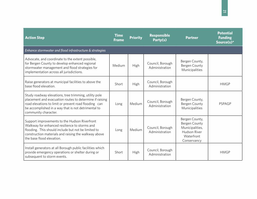
21Action Step
Time Frame
PriorityResponsible
Party(s)Partner
Potential Funding
Source(s)*
Enhance stormwater and flood infrastructure & strategies
Advocate, and coordinate to the extent possible, for Bergen County to develop enhanced regional stormwater management and flood strategies for implementation across all jurisdictions.
Medium HighCouncil, Borough Administration
Bergen County, Bergen County Municipalities
Raise generators at municipal facilities to above the base flood elevation.
Short HighCouncil, Borough Administration
HMGP
Study roadway elevations, tree trimming, utility pole placement and evacuation routes to determine if raising road elevations to limit or prevent road flooding can be accomplished in a way that is not detrimental to community character.
Long MediumCouncil, Borough Administration
Bergen County, Bergen County Municipalities
PSPAGP
Support improvements to the Hudson Riverfront Walkway for enhanced resilience to storms and flooding. This should include but not be limited to construction materials and raising the walkway above the base flood elevation.
Long MediumCouncil, Borough Administration
Bergen County, Bergen County Municipalities, Hudson River
Waterfront Conservancy
Install generators at all Borough public facilities which provide emergency operations or shelter during or subsequent to storm events.
Short HighCouncil, Borough Administration
HMGP

22Action Step
Time Frame
PriorityResponsible
Party(s)Partner
Potential Funding
Source(s)*
Adopt Enhanced Borough Policies To Facilitate Mitigation, Resilience & Adaptation
Prepare new and revised master plan elements that provide the investigation and policy foundation for creating a more resilient Edgewatr. At a minimum, these master plan elements should address the following:
Medium High Planning Board None PSPAGP
General
• Increase prominence and elevate the priority of goals, objectives and policies related to a mitigation, resilience and adaptation across all relevant master plan elements and provide coordinating policies across all master plan elements
• Provide greater opportunity for public and stakeholder participation in hazard mitigation, resilience and adaptation planning.
Medium High Planning Board None PSPAGP

23Action Step
Time Frame
PriorityResponsible
Party(s)Partner
Potential Funding
Source(s)*
Community Facilities
• Address resilience measures for Borough facilities, such as Borough Hall, police department, first aid and the department of public works.
Medium High Planning Board None PSPAGP
Conservation
• Identify natural resources in the Borough that can provide environmental services (such as providing flood capacity) and currently provide or could provide enhanced resilience to storm events.
Medium High Planning Board None PSPAGP
Open Space and Recreation
• Determine how the Borough’s public lands can not only provide environmental services but also recreation to Borough residents.
• Identify any lands in flood prone areas that should be considered for acquisition.
Medium High Planning Board None PSPAGP

24Action Step
Time Frame
PriorityResponsible
Party(s)Partner
Potential Funding
Source(s)*
Land Use
• Addresses how redevelopment in flood prone areas can reduce risk from weather events. This may include investigation of appropriate building and site design standards – building elevation, avoidance of clearing or construction practices that exacerbate risk and utilizing green infrastructure.
• Consider how zoning can be adjusted to encourage location of critical facilities in areas which have the lowest flood risk.
• Prepare neighborhood plans that target specific areas of the Borough such as but not limited to neighborhoods east of River Road. These plans should address how mitigation,resiliency and adaptation strategies can be incorporated in ways that contribute to the character of the area.
• Identify how green infrastructure can be used to provide short term and long term flood mitigation.
Medium High Planning Board None PSPAGP
Circulation
• Address safe evacuation of residents in response to flood events and road improvements that would enhance mitigation and resiliency to flooding.
• Identify opportunities to raise roadway elevations so as to reduce roadway flooding during storm events.
Medium High Planning Board None PSPAGP
25Action Step
Time Frame
PriorityResponsible
Party(s)Partner
Potential Funding
Source(s)*
Utilities
• Identify infrastructure which may be at risk during natural disasters and plan for its protection, resilience and adaptation through relocation or other means.
Medium High Planning Board None PSPAGP
Stormwater Management
• Provide an analysis, and redesign if necessary, of the Borough’s stormwater management facilities to ensure they continue to function during flood events.
Medium High Planning Board None PSPAGP
Adopt Ordinances Which Enhance Mitigation, Resilience & Adaptation In The Borough
Update the Borough’s general, Flood Prevention and Protection and Land Use ordinances to reflect the most recent flood hazard data and implement the relevant recommendations called for in the new and revised master plan elements.
Medium HighCouncil, Planning
BoardPSPAGP
Prepare design and zoning standards specific to flood hazard areas for the land use ordinance that will not only foster a sense of place in Edgewater but will set standards for flood resilience at the street level for public, residential, commercial and mixed use buildings.
Medium HighCouncil, Planning
BoardPSPAGP

26Action Step
Time Frame
PriorityResponsible
Party(s)Partner
Potential Funding
Source(s)*
Enhance Safety During Severe Storms
Identify facilities which may have difficulty or reluctance to evacuate in advance of severe storms (hotels, health care facilities, etc.) to establish procedures for preparing visitors and residents for severe storms and evacuation.
Short HighBorough
Administration
Encourage greater residents and business participation in the Reverse 911 system.
Short MediumBorough
Administration
Miscellaneous
Prepare an updated five year Capital Facilities Plan to identify municipal capital investment necessary to implement the recommendations in the revised Borough policies (such as, but not limited to, those found in the utilities plan and community facilities plan) and those for enhancing Borough Flood Infrastructure.
Medium MediumBorough Council, Administration
PSPAGP
Analyze the Borough enforcement procedures for the Construction office, Planning Board and Zoning Board to better enforce receipt of proper permits and approval for improvements to buildings and lands.
Medium MediumCouncil, Borough Administration
PSPAGP
* Glossary of Abbreviations
PSPAG: New Jersey Department of Community Affairs (NJ DCA) Post Sandy Planning Assistance Grant ProgramHMGP: Federal Emergency Management Agency (FEMA) Hazard Mitigation Grant ProgramNJEIT: New Jersey Environmental Infrastructure Trust (loan program)

27
STRATEGIC RECOVERY PLANNING REPORT | BOROUGH OF EDGEWATER, BERGEN COUNTY, NEW JERSEY
ENDNOTES
Superstorm Sandy
1 Blake, Eric S.; Kimberlain, Todd B.; Berg, Robert J.; Cangialosi. John P. and Beven, John L., II. Tropical Cyclone Report, Hurricane Sandy. National Hurricane Center. February 12, 2013.
2 Centers for Disease Control and Prevention. “Deaths Associated with Hurricane Sandy October–November 2012.” Weekly. May 24, 2013. 62(20);393-397. Accessed: September 30, 2014. http://www.cdc.gov/mmwr/preview/mmwrhtml/mm6220a1.htm
3 Borough of Edgewater, NJ FEMA Project Worksheet
4 Bergen County Multi-Jurisdictional All-Hazards Mitigation Plan, Update 2015. p. 3-43
Existing Conditions5 Conversation with Franz, Gregory, Edgewater Borough Administrator
6 Bergen County Multi-Jurisdictional All-Hazards Mitigation Plan, Update 2015. p. 3-43
7 2014 FEMA Preliminary Flood Insurance Rate Maps
8 Bergen County Multi-Jurisdictional All-Hazards Mitigation Plan, Update 2015. p. 2-13 to 2-15
9 Bergen County Multi-Jurisdictional All-Hazards Mitigation Plan, Update 2015. p. 2-14 to 2-15
10 Borough of Edgewater Initial General Complaint Reports provided by Gregory Franz, Edgewater Borough Administrator
11 Conversation with Franz, Gregory, Edgewater Borough Administrator
12 Conversation with Franz, Gregory, Edgewater Borough Administrator
13 PSE&G Electric Service Area: Bergen County. Accessed: September 4, 2015. https://www.pseg.com/home/customer_service/electric-service_area.jsp#anchor5
14 Input from September 28, 2015 Public Meeting
15 Conversation with Franz, Gregory, Edgewater Borough Administrator
16 Bergen County Evacuation Routes Map. http://www.state.nj.us/njoem/pdf/bergen%20county%20evacuation.pdf
17 Conversation with Franz, Gregory, Edgewater Borough Administrator
Damage From Superstorm Sandy
18 Delaney, James. “Hurricane Sandy Mayor Report.” Edgewater-Residential.com. November 11, 2012. Accessed: October 6, 2014. Available at: http://www.edgewaterresidential.com/2012/11/hurricane-sandy-mayor-report/
19 Private Property Damage Assessment. Prepared by John Candelmo,
Edgewater Borough Construction Official, and Neglia Engineering
20 Conversation with Franz, Gregory, Edgewater Borough Administrator
21 Conversation with Franz, Gregory, Edgewater Borough Administrator
22 Delaney, James. “Hurricane Sandy Mayor Report.” EdgewaterResi-dential.com. November 11, 2012. Accessed: October 6, 2014. Avail-able at: http://www.edgewaterresidential.com/2012/11/hurricane-sandy-mayor-report/
23 Conversation with Franz, Gregory, Edgewater Borough Administrator
24 Delaney, James. “Hurricane Sandy Mayor Report.” EdgewaterResi-dential.com. November 11, 2012. Accessed: October 6, 2014. Avail-able at: http://www.edgewaterresidential.com/2012/11/hurricane-sandy-mayor-report/
25 Damaged Structures Reported to the Borough or That Required a Building Permit
26 Damaged Structures Reported to the Borough or That Required a Building Permit
27 Conversation with Franz, Gregory, Edgewater Borough Administrator
28 Shkolnikova, Svetlana. “Edgewater Still Recovering From ‘Super-storm.’” Northjersey.com. November 9, 2012. Accessed: Septem-ber 3, 2015. http://www.northjersey.com/news/edgewater-still-recovering-from-superstorm-1.496063?page=all
29 Conversation with Franz, Gregory, Edgewater Borough Administrator
30 Delaney, James. “Hurricane Sandy Mayor Report.” EdgewaterResi-dential.com. November 11, 2012. Accessed: October 6, 2014. Avail-able at: http://www.edgewaterresidential.com/2012/11/hurricane-sandy-mayor-report/
31 Conversation with Franz, Gregory, Edgewater Borough Administrator
32 Conversation with Franz, Gregory, Edgewater Borough Administrator
33 Neglia Engineering Associates Memorandum re: Veterans Field Improvements, Superstorm Sandy Damage and Delays. March 4, 2013.
34 Tat, Bylinh. “Edgewater Officials May Pull Waterside Construction Off Veterans Field Cleanup.” Bergen County Record. October 31, 2013. Accessed: September 29, 2014. http://www.northjersey.com/story-archives/edgewater-officials-may-pull-waterside-construction-off-veterans-field-cleanup-1.585854
35 Tat, Bylinh. “Edgewater Replaces Original Firm Hired to Clean Up Park Contamination.” Bergen County Record. September 24, 2014. Accessed: September 29, 2014. http://www.northjersey.com/news/edgewater-replaces-original-firm-hired-to-clean-up-park-contamination-1.1095407
28
BOROUGH OF EDGEWATER, BERGEN COUNTY, NEW JERSEY | STRATEGIC RECOVERY PLANNING REPORT
Vulnerabilities & Opportunities Highlighted by Superstorm Sandy
36 Conversation with Franz, Gregory, Edgewater Borough Administrator
37 Critical Facilities List from Franz, Gregory
38 Bergen County Multi-Jurisdictional All-Hazards Mitigation Plan, Update 2015. p. 3-33,3-38
39 Conversation with Franz, Gregory, Edgewater Borough Administrator
40 Borough of Edgewater Initial General Complaint Report. Case Num-ber 2012-008010. October 29, 2012
41 Delaney, James. “Hurricane Sandy Mayor Report.” Edgewater-Residential.com. November 11, 2012. Accessed: October 6, 2012. Available at: http://www.edgewaterresidential.com/2012/11/hurricane-sandy-mayor-report/
42 Conversation with Franz, Gregory, Edgewater Borough Administra-tor
43 Conversation with Franz, Gregory, Edgewater Borough Administrator
44 Conversation with Franz, Gregory, Edgewater Borough Administra-tor
45 Conversation with Franz, Gregory, Edgewater Borough Administra-tor
46 2010 US Census and 2012 American Community Survey
47 Delaney, James. “Hurricane Sandy Mayor Report.” Edgewater-Residential.com. November 11, 2012. Accessed: October 6, 2012. Available at: http://www.edgewaterresidential.com/2012/11/hurricane-sandy-mayor-report/
48 Conversation with Franz, Gregory, Edgewater Borough Administra-tor
49 Conversation with Franz, Gregory, Edgewater Borough Administra-tor
50 Delaney, James. “Hurricane Sandy Mayor Report.” Edgewater-Residential.com. November 11, 2012. Accessed: October 6, 2012. Available at: http://www.edgewaterresidential.com/2012/11/hurricane-sandy-mayor-report/
51 Delaney, James. “Hurricane Sandy Mayor Report.” Edgewater-Residential.com. November 11, 2012. Accessed: October 6, 2012. Available at: http://www.edgewaterresidential.com/2012/11/hurricane-sandy-mayor-report/
52 Conversation with Franz, Gregory, Edgewater Borough Administrator
53 Bergen County Multi-Jurisdictional All-Hazards Mitigation Plan, Update 2015. p. 3-88
54 Bergen County Multi-Jurisdictional All-Hazards Mitigation Plan, Update 2015. p. 3-89
55 Borough of Edgewater Summary of Assessments 2004-2013 Tax Years; Bergen County 2014 Tax List District Summary and 2014 Preliminary Equalization Table
56 New Jersey Climate Adaptation Alliance (NJCAA). 2013. Resilience. Preparing New Jersey for Climate Change: A Gap Analysis from
the New Jersey Climate Adaptation Alliance. Edited by Matt Campo, Marjorie Kaplan, Jeanne Herb. New Brunswick, New Jersey: Rutgers University
57 Future Climate Change. United States Environmental Protection Agency. Accessed March 12, 2014 http://www.epa.gov/climat-echange/science/future.html#sealevel.
58 New Jersey Climate Adaptation Alliance (NJCAA). 2013. Resilience. Preparing New Jersey for Climate Change: A Gap Analysis from the New Jersey Climate Adaptation Alliance. Edited by Matt Campo, Marjorie Kaplan, Jeanne Herb. New Brunswick, New Jersey: Rutgers University.
59 IPCC, 2013: Summary for Policymakers. In: Climate Change 2013: The Physical Science Basis. Contribution of Working Group I to the Fifth Assessment Report of the Intergovernmental Panel on Climate Change [Stocker, T.F., D. Qin, G.-K. Plattner, M. Tignor, S.K. Allen, J. Boschung, A. Nauels, Y. Xia, V. Bex and P.M. Midgley (eds.)]. Cambridge University Press, Cambridge, United Kingdom and New York, NY, USA.
60 NOAA, FEMA, USACE, USGCRP, and CEQ. Scenarios from Global Sea Level Rise Scenarios for the United States National Climate Assessment. Published: December 6, 2012. Maps available at: http://geoplatform.maps.arcgis.com/home/item.html?id=2960f1e066544582ae0f0d988ccb3d27
61 Borough of Edgewater Municipal Stormwater Management Plan. October 6, 2008. p. 3-6
62 Borough of Edgewater Emergency Operations Plan, Basic Plan, Revised February 2006. p. 9-10
63 Bergen County Multi-Jurisdictional All-Hazards Mitigation Plan, Update 2015. p. 3-1 et seq.
64 Bergen County Multi-Jurisdictional All-Hazards Mitigation Plan, Update 2015. p. 3-28
65 2008 Bergen County Natural Hazard Mitigation Plan. p. 265-267
66 Bergen County Multi-Jurisdictional All-Hazards Mitigation Plan, Update 2015. p. H-14
67 Bergen County Multi-Jurisdictional All-Hazards Mitigation Plan, Update 2015. p. J-3, J-4
68 Bergen County Multi-Jurisdictional All-Hazards Mitigation Plan, Update 2015. p. 3-29
69 Borough of Edgewater. Draft 2014 Master Plan Reexamination Report. January 22, 2014. p. 2
70 Borough of Edgewater. 1990 Master Plan, Land Use Plan. p. 63
71 Borough of Edgewater Code, §240-79.A
72 Borough of Edgewater Municipal Stormwater Management Plan. October 6, 2008. p. 3-4
73 Borough of Edgewater Code, §210
74 Borough of Edgewater Code, §210-11.B(3)
75 Borough of Edgewater Code, §210-18
76 Borough of Edgewater Code, §210-17
77 Borough of Edgewater Code, §374-16.C
29
STRATEGIC RECOVERY PLANNING REPORT | BOROUGH OF EDGEWATER, BERGEN COUNTY, NEW JERSEY
78 Borough of Edgewater Municipal Stormwater Management Plan. October 6, 2008. p. 4
79 Borough of Edgewater Code, §240-87
80 Borough of Edgewater Code, §374-4.E
81 Borough of Edgewater Code, §374-14.B
82 Borough of Edgewater Municipal Stormwater Management Plan. October 6, 2008. p. 4
83 Borough of Edgewater Code, §374-14.C
84 Borough of Edgewater Municipal Stormwater Management Plan. October 6, 2008. p. 6
85 Borough of Edgewater Emergency Operations Plan, Basic Plan, Revised February 2006. p. 11
86 Borough of Edgewater Emergency Operations Plan. Shelter Recep-tion and Care Annex, Revised August 1997. p. 7
87 Borough of Edgewater Emergency Operations Plan. Emergency Pub-lic Information Annex, Revised February 1998. Appendix EPIA-8
88 Borough of Edgewater Emergency Operations Plan. Emergency Pub-lic Information Annex, Revised February 1998. Appendix EPIA-5
89 Delaney, James. “Hurricane Sandy Mayor Report.” Edgewater-Residential.com. November 11, 2012. Accessed: October 6, 2014. Available at: http://www.edgewaterresidential.com/2012/11/hurricane-sandy-mayor-report/
90 Borough of Edgewater website. Accessed: September 30, 2015. http://www.edgewaternj.org/
91 Borough of Edgewater Emergency Operations Plan. Evacuation An-nex, Revised November 1997. p. 3
92 Borough of Edgewater Emergency Operations Plan. Evacuation An-nex, Revised November 1997. Appendix EA-8
93 Borough of Edgewater Emergency Operations Plan. Evacuation An-nex, Revised November 1997. Appendix EA-10
94 Conversation with Franz, Gregory, Edgewater Borough Administra-tor
95 Borough of Edgewater Municipal Stormwater Management Plan. October 6, 2008. p. 5-6
96 Borough of Edgewater Code, §374-4.E(2)
97 Borough of Edgewater. Draft 2014 Master Plan Reexamination Report. January 22, 2014. p. 2
98 Borough of Edgewater. 1990 Master Plan, Land Use Plan. p. 63
99 Borough of Edgewater. Draft 2014 Master Plan Reexamination Report. January 22, 2014. p. 3-4
100 Borough of Edgewater Municipal Stormwater Management Plan. October 6, 2008. p. 12
101 Borough of Edgewater Municipal Stormwater Management Plan. October 6, 2008. p. 5
102 Bergen County Multi-Jurisdictional All-Hazards Mitigation Plan, Update 2015. p. 4-1,4-2
103 Bergen County Stormwater Management Program, Performance
and Design Standards
104 Bergen County Multi-Jurisdictional All-Hazards Mitigation Plan, Update 2015. p. 1-4
105 Bergen County Multi-Jurisdictional All-Hazards Mitigation Plan, Update 2015. p. 3-11
106 Bergen County Multi-Jurisdictional All-Hazards Mitigation Plan, Update 2015. p. 1-4, 1-5
107 Bergen County Multi-Jurisdictional All-Hazards Mitigation Plan, Update 2015. p. 1-4
108 Bergen County Multi-Jurisdictional All-Hazards Mitigation Plan, Update 2015. p. 1-5
109 Bergen County Multi-Jurisdictional All-Hazards Mitigation Plan, Update 2015. p. 1-4
110 Bergen County Multi-Jurisdictional All-Hazards Mitigation Plan, Update 2015. p. 1-5
Action Steps to Date
111 Conversation with Franz, Gregory, Edgewater Borough Administrator
112 Conversation with Franz, Gregory, Edgewater Borough Administra-tor
113 State of New Jersey Hazard Mitigation Grant Program Municipal Letters of Intent
114 Conversation with Franz, Gregory, Edgewater Borough Administra-tor
115 FEMA Subgrant Applications and Project Worksheets compiled on March 26, 2013
116 Olga Bobylak. Borough of Edgewater JIF Claims Report. The Vozza Agency. January 31, 2012
117 State of New Jersey Hazard Mitigation Grant Program Municipal Letters of Intent
118 Conversation with Franz, Gregory, Edgewater Borough Administra-tor
119 Letter from Michael Gallagher, SFC, Assistant Unit Head, Mitigation Unit, Emergency Management Section of the New Jersey State Police to Barbara Rae, Edgewater Municipal Clerk. May 14, 2015
120 Letter from Michael Gallagher, SFC, Assistant Unit Head, Mitiga-tion Unit, Emergency Management Section of the New Jersey State Police to Barbara Rae, Edgewater Municipal Clerk. May 14, 2015.
121 Conversation with Franz, Gregory, Edgewater Borough Administra-tor
122 State of New Jersey Hazard Mitigation Grant Program Municipal Letters of Intent
123 Bergen County Multi-Jurisdictional All-Hazards Mitigation Plan, Update 2015. p. J-10. Unless otherwise cited, all information in this section is from this plan or the 2008 Bergen County Natural Hazard Mitigation Plan.
124 2008 Bergen County Natural Hazard Mitigation Plan. p. 266

30
BOROUGH OF EDGEWATER, BERGEN COUNTY, NEW JERSEY | STRATEGIC RECOVERY PLANNING REPORT
125 Letter from Michael Gallagher, SFC, Assistant Unit Head, Mitigation Unit, Emergency Management Section of the New Jersey State Police to Barbara Rae, Edgewater Municipal Clerk. May 14, 2015.
126 Conversation with Franz, Gregory, Edgewater Borough Administra-tor
127 Bergen County Multi-Jurisdictional All-Hazards Mitigation Plan, Update 2015. p. J-10. Unless otherwise cited, all information in this section is from this plan or the 2008 Bergen County Natural Hazard Mitigation Plan.
128 2008 Bergen County Natural Hazard Mitigation Plan. p. 266
129 Bergen County Multi-Jurisdictional All-Hazards Mitigation Plan, Update 2015. p. F-4
130 Conversation with Franz, Gregory, Edgewater Borough Administra-tor
131 Bergen County Multi-Jurisdictional All-Hazards Mitigation Plan, Update 2015. p. H-14
Recommended Action Steps
132 Rebuild by Design. Accessed: September 15, 2015. http://www.rebuildbydesign.org/what-is-rebuild-by-design/
133 Rebuild by Design. Accessed: September 16, 2015. http://www.rebuildbydesign.org/winners-and-finalists/
134 OMA. “Resist, Delay, Store, Discharge: A Comprehensive Strategy for Hoboken.” 2014. Appendix 1- Design Approach presentation
135 OMA. “Resist, Delay, Store, Discharge: A Comprehensive Strategy for Hoboken.” 2014. p. 13
136 OMA. “Resist, Delay, Store, Discharge: A Comprehensive Strategy for Hoboken.” 2014. Appendix 1- Design Approach presentation
137 OMA. “Resist, Delay, Store, Discharge: A Comprehensive Strategy for Hoboken.” 2014. Appendix 1- Design Approach presentation
138 OMA. “Resist, Delay, Store, Discharge: A Comprehensive Strategy for Hoboken.” 2014. Appendix 1- Design Approach presentation
139 OMA. “Resist, Delay, Store, Discharge: A Comprehensive Strategy for Hoboken.” 2014. p. 24
140 Rebuild by Design. Accessed: September 16, 2015. http://www.rebuildbydesign.org/winners-and-finalists/
141 WXY and West 8. “Blue Dunes – The Future of Coastal Protection.” p. 50
142 WXY and West 8. “Blue Dunes – The Future of Coastal Protection.” p. 115

31
STRATEGIC RECOVERY PLANNING REPORT | BOROUGH OF EDGEWATER, BERGEN COUNTY, NEW JERSEY
Reported Road Flood Events (10/29/2012-8/11/2015)
Date Location
10/29/2012 River Road and Dempsey Avenue
10/29/2012 1225 River Road
1/31/2013 880 River Road
5/8/2013 880 River Road
5/8/2013 478 River Road
5/8/2013 461 River Road
5/8/2013 880 River Road
5/9/2013 880 River Road
5/23/2013 880 River Road
6/3/2013 880 River Road
6/3/2013 880 River Road
6/3/2013 880 River Road
6/7/2013 880 River Road
6/13/2013 905 River Road
7/1/2013 902 River Road
8/22/2013 880 River Road
2/24/2014 461 River Road
3/20/2014 880 River Road
4/30/2014 880 River Road
APPENDIX: A

32
BOROUGH OF EDGEWATER, BERGEN COUNTY, NEW JERSEY | STRATEGIC RECOVERY PLANNING REPORT
Reported Road Flood Events (10/29/2012-8/11/2015)
Date Location
5/10/2014 880 River Road
5/24/2014 880 River Road
6/9/2014 880 River Road
6/13/2014 880 River Road
7/2/2014 Route 5/Undercliff Avenue
7/2/2014 880 River Road
7/3/2014 880 River Road
7/14/2013 River Road and Dempsey Avenue
7/14/2014 Route 5/Undercliff Avenue
8/31/2014 River Road and Hilliard Avenue
11/17/2014 880 River Road
12/9/2014 880 River Road
2/16/2015 Undercliff Avenue and Garden Place
4/20/2015 980 River Road
5/31/2015 880 River Road
6/5/2015 880 River Road
6/16/2015 880 River Road
7/30/2015 880 River Road
8/11/2015 880 River Road

33
STRATEGIC RECOVERY PLANNING REPORT | BOROUGH OF EDGEWATER, BERGEN COUNTY, NEW JERSEY
APPENDIX: BDamaged Structures Reported to the Borough or That Required a Building Permit
Address Block Lot Use Type Project Name Damage
115 River Road 96 3.01Non-residential
n/a Basement flooding, walkway
1257 River Road 22 4Non-residential
Le Jardin Wind (roof, air conditioner)
1339 River Road 171, 2, 3.02
Non-residential
Von Dohln Marina Docks, building, boats
1375 River Road 12 5Non-residential
North Hudson Yacht Club
Boats, fencing
225 River Road 92 3Non-residential
City PlaceWind (windows in 600 building), flooding in parking garage and Verizon store
525 River Road 84.01 1.01Non-residential
Edgewater CommonsEquipment, main sewer line, food at Target, compact motor
541 River Road 84.01 1.02Non-residential
Crab HouseWind (glass wall on southeast corner of patio blew out)
575 River Road 82 1Non-residential
Edgewater Golf RangeNets, walkway, miniature golf course
595 River Road 81 1Non-residential
Mitsuwa Water in store
715 River Road 75 2.02Non-residential
Trader Joe’s Water in store, wood floors buckled
725 River Road 75 8Non-residential
Marketplace 3-6 inches of water in all stores
737 River Road 70 3Non-residential
Binghamton Racquet Club
Flooding, east wall
75 River Road 99 1Non-residential
iPark Wind (windows)
905 River Road 58 1Non-residential
Edgewater Center River walkway, landscaping
955 River Road 38 1Non-residential
Lukoil/Dunkin Donuts Water in store
1 Shore Road 1 1 Residential The Colony Flooding

34
BOROUGH OF EDGEWATER, BERGEN COUNTY, NEW JERSEY | STRATEGIC RECOVERY PLANNING REPORT
Damaged Structures Reported to the Borough or That Required a Building Permit
Address Block Lot Use Type Project Name Damage
105 Lighthouse Terrace
85.01 1.01 ResidentialRiver Club Apartments
10-12 cars, garage flooding, wind (trees and fencing)
1111 River Road 33 1.02 Residential Water’s Ebb Two cars flooded
1203 River Road 25 8 Residential Hudson HarborFirst floor flooding, pump station flooding, cars, wind (front door blew in and roof)
1225 River Road 25 3 Residential Shelter BayFirst floor flooding in 60 units, ejector pumps, 15-20 cars
1321 River Road 182.01, 2.02
Residential The MooringsWind (walkway, gazebo, air conditioner in one unit)
361 River Road 85.01 2 Residential Independence HarborWind (fencing and trees), flooding in Jefferson and Penn Court buildings
4 Washington Lane
1 1 Residential The Colony Flooding
5 Shore Road 1 1 Residential The Colony Flooding
945 River Road 46 3.01 ResidentialWindsor at Mariners Tower
Walkway, roof, cars flooded
986 River Road 39 1 Residential Admirals WalkFirst floor and vehicle flooding, generator in one building, elevators, wind (trees)
989 River Road 38 1 Residential Grand Cove MarinaFirst floor flooding, community center, walkway, wind (trees, fencing, roof)
Hudson Cove (specific address unknown)
25 2 Residential Hudson Cove Ejector pumps
980 River Road 44 3 Residential n/a Flooding, electrical system
The Colony (specific address unknown)
1 1 Residential The Colony Flooding
1257 River Road 22 4 Residential Le Jardin Wind


