CHAPTER 3 The Cambodia Development Triangle Area Sau Sisovanna This chapter should be cited as: Sau, Sisovanna, 2012. “The Cambodia Development Triangle Area.” In Five Triangle Areas in The Greater Mekong Subregion, edited by Masami Ishida, BRC Research Report No.11, Bangkok Research Center, IDE-JETRO, Bangkok, Thailand.
Transcript
CHAPTER 3
The Cambodia Development Triangle
Area
Sau Sisovanna
This chapter should be cited as:
Sau, Sisovanna, 2012. “The Cambodia Development Triangle Area.” In Five Triangle
Areas in The Greater Mekong Subregion, edited by Masami Ishida, BRC Research
Report No.11, Bangkok Research Center, IDE-JETRO, Bangkok, Thailand.
CHAPTER 3
THE CAMBODIA DEVELOPMENT TRIANGLE AREA
Sau Sisovanna
INTRODUCTION
The establishment of the Cambodia-Laos-Vietnam Development Triangle Area
(CLV-DTA) was decided by the three governments in 2004. It is comprised of 10
provinces of which three (Ratanak Kiri, Stung Treng and Mondol Kiri) are in Cambodia,
three (Attapeu, Sekong and Saravane) are in Lao PDR and four (Kon Tum, Dak Lak, Gia
Lai and Dak Nong) are in Vietnam. Originally, the development triangle, initiated in 1999,
was to focus on seven provinces: Ratanak Kiri and Stung Treng in Cambodia, Attapeu and
Sekong in Lao PDR and Kon Tum, Dak Lak and Gia Lai in Vietnam. These provinces all
have similar terrain, climate, and socio-economic background providing great potential for
agriculture, forestry, mining, tourism, trade and related industries. The fourth summit
meeting of the CLV Development Triangle was held in Vietnam in December 2006. The
prime ministers of CLV countries reaffirmed initiatives and decisions approved at the
previous meetings on building the Development Triangle in order to hasten economic
growth, reduce poverty and promote cultural and social progress in the region on the basis
of bringing into play the potential and advantages of each country, simultaneously
contributing actively to peace, consolidation, stability, integration and development.
At a meeting of the Joint Coordination Committee of the three countries of CLV- DTA,
held in Dak Lak on December 21-22 in 2009, the three countries agreed to add the
provinces of Kratie (Cambodia), Champasack (Lao PDR) and Binh Phuoc (Vietnam) to the
CLV-DTA. The Cambodian member provinces of the Cambodia-Laos-Vietnam
Development Triangle (CDTA) include Kratie, Mondol Kiri, Ratanak Kiri and Stung Treng
provinces, which are located in the border areas of the three countries and share many
similarities in terms of nature, geography, economy, and social conditions. The
development level of these provinces is generally lower than the national level. The Royal
Government of Cambodia (RGC), like other regional governments, believes that a 56
development triangle may form as a result of full scale economic integration, which is a
vehicle to attract foreign direct investment and promote economic growth for specific
periods of time.
The benefits of economic cooperation from the establishment of triangle areas have
been stressed to date. Anne Marie Humphries says that a growth triangle is primarily an
economic concept, although it is underpinned by strong political motivations. These include
the domestic imperative to spread the benefits of economic growth to less-developed areas
of national economies and a desire to improve political and strategic relations with
neighboring countries.1 Bhoj Raj Khanal and Wilairat Tongsiri suggested that building a
development triangle hastens economic growth, reduces poverty and promotes cultural and
social progress in the region on the basis of bringing into play the potential and advantages
of each country. Simultaneously, active contributions are made to peace, consolidation,
stability, integration and development (Khanal and Tongsiri, 2007). The Ministry of
Planning and Investment in Vietnam reaffirmed that development triangles are also
significant in consolidating peace and security in the region and helping maintain internal
security of the countries involved thanks to the economic benefits that they bring about. It
has also been noted that an expanded economic exchange resulting from cross-border trade
activities enhances mutual cultural understanding of the countries involved and, hence, the
improvement of border security.2 The World Technologies Evaluation Center (WTEC)
confirmed that regional cooperation provides a competitive model to attract investment and
technology (Boulton, 1997). Sonya Chum noted that the first motive of Vietnamese
strategy is to form, at the earliest stage of economic development of the Least Developed
Countries, a group in order to gain a stronger voice to raise increased economic assistance
more effectively from external institutions at regional and international levels (Chum,
2010). Anne Marie Humphries has also provided a definition of a development triangle: it
consists of geographically proximate areas of three or more countries where differences in
factor endowments (such as the availability of land, labour, and capital) create economic
complementarities which can be exploited to gain a competitive edge in promoting external
trade and investment for the mutual benefit of participating countries. Discussion of
Source: Compiled by the author in accordance with the General Population Census of Cambodia 2008(MOP, 2009).
61
groups include the Chinese, Vietnamese, Lao, Cham and indigenous minorities. The Khmer
ethnic group is approximately 90% of the population of Cambodia, while indigenous
groups constitute about 1%. Indigenous ethnic minorities in Cambodia are often called hill
tribes or highlanders because most of these people live in the four northeastern provinces:
Ratanak Kiri, Stung Treng, Mondol Kiri and Kratie.
The Cambodia Population Census in 2008 identified 33 ethic indigenous minority
groups in Cambodia based on their spoken language. The total number of indigenous
people was about 159,009 or 1.18% of the total population (MOP, 2009).
In general, the ethnic Khmer group is a majority of the population in the capital of
Cambodia and almost all provinces except for Mondol Kiri and Ratanak Kiri. In Mondol
Kiri, ethnic Khmers (43.38%) are less than the Phnong minority (44.61%), while in
Ratanak Kiri province, even though the ethnic majority is Khmer, the total number of
ethnic indigenous minorities is greater than the Khmer: Tumpoon (20.52%), Chaaraay
(13.78%), Krueng (13.1%), Lao (7.52%) and Praov (5.67%). Indigenous minority groups in
Kratie and Stung Treng provinces represent around 7% of the provincial population in each
province (Table 2). The high number of ethnic indigenous minorities in these two provinces,
Ratanak Kiri and Mondol Kiri, suggests why they are more difficult to develop than Kratie
and Stung Treng.
1.4. Social Development Status in CDTA Provinces
1.4.1. Educational Development Status in CDTA Provinces The educational level is lower than the country level. The literacy rate average (60.5%) is
lower than country rate (77.59%). The literacy rate of Kratie (73.74%) is the highest among
CDTA provinces, while Ratanak Kiri (45.90%) is the lowest in CDTA as well as in the
country. The average net attendance ratio for primary school (72.55%) is also lower than
the country net attendance ratio (84.8%). In secondary schools of Ratanak Kiri, Stung
Treng, Mondol Kiri and Kratie provinces, the net attendance ratio is 21.1%, 28.8%, 21.3%
and 34.2%, respectively, and they are all lower than the net attendance ratio for secondary
schools of the whole country 41.3% (Table 3). The illiteracy rate is very high, particularly
62
Table 2: Ethnic Minorities in Cambodia provinces DTA-CLV
(%)
No Minorities Kratie Mondul Kiri Ratanak Kiri Stung Treng
1 Khmer 85.69 43.38 32.75 90.80
2 Cham 5.48 5.40 1.10 1.38
3 Lao 3.38 7.52 1.54
4 Chaaraay 13.78
5 Kaaveat 2.64
6 Kuoy 1.55 1.48
7 Krueng 13.1
8 Phnong 2.90 44.61
9 Proav 5.67
10 Tumpoon 20.52
11 Stieng 1.40
12 Roong
13 Kraol 1.08 Source: The General Population Census of Cambodia 2008(MOP, 2009).
in Stung Treng, Ratanak Kiri and Mondol Kiri provinces. Human resources have been
found to be greatly inadequate and poor, while the percentage of qualified workers is very
low.
Educational infrastructure, such as school buildings and facilities, is insufficient and in
poor condition. More than 50% of school buildings in the area are seen to lack floors, roofs,
and walls. The shortage of school buildings is one of the major causes of the high drop-out
rate as students are less motivated to go to schools which are far from home and where road
access is difficult. The area also faces a shortage of teachers, while those now teaching have
limited capacity and need to be trained. Parents have low education levels and poor general
knowledge, especially among indigenous people. Lack of education is a significant
constraint and poses a huge challenge for local authorities (Master Plan CLV-DTA 2010).
To date, education in CDTA provinces has been improved year-by-year along with an
improvement in physical infrastructure and the establishment of a secure environment.
Efforts by local authorities, the national government, development partners and civil society
have been the crucial factors contributing to an improved educational sector in CDTA
provinces. 63
However, there is still a shortage of vocational training schools in the provinces. A
huge area for recent private investment in agro-industrial crops and plantation has been
recently approved by national and local governments, highlighting the considerable need
for skilled workers in CDTA provinces. The training courses provided by provincial
departments in various skills, such as sewing, computer skills, driving and the English
language are limited due to financial constraints. Vietnam has assisted in establishing
vocational school systems in Ratanak Kiri and Mondol Kiri provinces (Master Plan
CLV-DTA 2010).
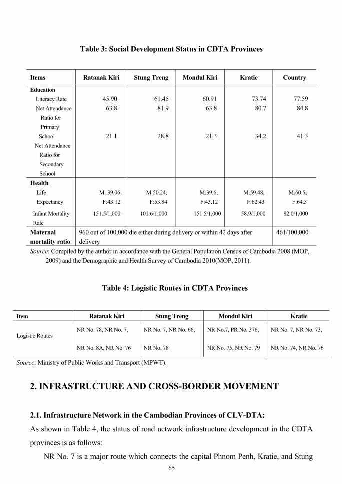
1.4.2. Health Development Status in CDTA Provinces
Healthcare in CDTA provinces is very poor. The average life expectancy at birth in
Ratanak Kiri and Mondol Kiri (males: 39.6 years, females: 43.12 years) is lower than
Kratie and Stung Treng statistics which show male and female life expectancy at 59.48
years, 62.43 years, and 50.24 years, 53.84 years, respectively; the former two provinces are
much lower than the country level of 60.5 years for males and 64.3 years for females. Infant
mortality rates under one year in Ratanak Kiri, Stung Treng and Mondol Kiri are
151.5/1,000, 101.6/1,000 and 151.5/1,000, respectively. These figures are higher compared
to the whole country rate (61/1,000), except Kratie province (58.9/1,000). The average
maternal mortality rate in these provinces is also quite high; 960/100,000 die either during
delivery or within 42 days after delivery compared to the country rate of 461/100,000
(Table 3). This figure is more than twice that of the country average rate. The poor health of
CDTA provincial residents can be attributed to a variety of factors, including poverty,
remoteness and isolation of villages, difficult transport conditions in the area, poor quality
medical services, and language and cultural barriers, such as the existence of many
backward practices and customs that prevent indigenous minority people from obtaining
medical care. Medical equipment and supplies are minimal and most health facilities are
staffed by nurses or midwives who are often poorly trained and lacking professional
experience. Such a situation affects the quality of health checkups, disease prevention and
recovery.
64
Table 3: Social Development Status in CDTA Provinces
Items Ratanak Kiri Stung Treng Mondul Kiri Kratie Country
Education Literacy Rate Net Attendance
Ratio for Primary
School Net Attendance
Ratio for Secondary School
45.90 63.8 21.1
61.45 81.9 28.8
60.91 63.8 21.3
73.74 80.7 34.2
77.59 84.8 41.3
Health Life
Expectancy
Infant Mortality Rate
M: 39.06; F:43:12
151.5/1,000
M:50.24; F:53.84
101.6/1,000
M:39.6; F:43.12
151.5/1,000
M:59.48; F:62.43
58.9/1,000
M:60.5; F:64.3
82.0/1,000
Maternal mortality ratio
960 out of 100,000 die either during delivery or within 42 days after delivery
461/100,000
Source: Compiled by the author in accordance with the General Population Census of Cambodia 2008 (MOP, 2009) and the Demographic and Health Survey of Cambodia 2010(MOP, 2011).
Table 4: Logistic Routes in CDTA Provinces
Item Ratanak Kiri Stung Treng Mondul Kiri Kratie
Logistic Routes NR No. 78, NR No. 7,
NR No. 8A, NR No. 76
NR No. 7, NR No. 66,
NR No. 78
NR No.7, PR No. 376,
NR No. 75, NR No. 79
NR No. 7, NR No. 73,
NR No. 74, NR No. 76
Source: Ministry of Public Works and Transport (MPWT). 2. INFRASTRUCTURE AND CROSS-BORDER MOVEMENT
2.1. Infrastructure Network in the Cambodian Provinces of CLV-DTA:
As shown in Table 4, the status of road network infrastructure development in the CDTA
provinces is as follows:
NR No. 7 is a major route which connects the capital Phnom Penh, Kratie, and Stung 65
Treng to the Laotian border and NR No.13 of Laos. The section from Kratie provincial
town via Stung Treng to the Lao border is about 196.8 km, while the part within Stung
Treng is 82 km. At present, the width of the roadbed is 11m and that of the asphalted
surface is 9 m. Construction of a large bridge crossing the Sekong River in Stung Treng
town has been completed. Though the construction has been recently finished, some
sections of the route require frequent rehabilitation due to flooding and/or overweight
transport vehicles.
The NR No. 78 is a key route connecting Phnom Penh, Kratie, and Stung Treng via
NR 7 to Ratanak Kiri province. This route starts from NR7 at O’Pong Morn via Banlung,
Ratanak Kiri town to the O’Yadav (Cambodian)–Le Thanh (Vietnam) border crossing. Its
total length is about 191 km. Section 1 from O’Pong Morn to Ban Lung is 121 km with two
lanes of Double Bituminous Surface Treatment (DBST) and has recently been inaugurated
by the Prime Minister. The civil engineering work was carried out by a Chinese company.
Section 2, from Ban Lung to the Cambodian-Vietnamese border (about 70 km in length),
was finished with AC pavement funded by a Vietnamese loan. This route is very important
as it connects the Northern Sub-Corridor of the Southern Economic Corridor to the
international border crossing at O’Yadav-Le Thanh and subsequently to the Vietnamese
international ports of Quy Nhon and Danang.
Provincial road No. 3785 is the main route connecting Ratanak Kiri to the Lao border.
This road starts from its intersection with NR No. 78 at Ban Lung and continues through
Voeun Sai, following the direction of former NR No. 301. It approaches the Sekong River
at Siem Pang, running alongside it to the Lao border and connecting with NR No. 1J of
Laos. It is expected to be about 150 km in length. At the moment, it is 80 km of graveled
and earthen road and the remaining 70 km are in a planning phase.
NR No. 93 is also a principal route connecting Stung Treng province with Preah
Vihear provincial town and with provinces further on. A route going from Stung Treng
provincial town crosses the Mekong River at the Mekong River Bridge in Stung Treng. The
bridge was constructed by a Chinese company and will be completed by year 2014. The
total length of NR No. 9 is 143.412 km. The civil engineering work was done by a Chinese
company and will be completed by 2014. NR No. 64 is a major route connecting Preah 3 This road used to be called NR No. 64 and is also a part of the Northern Sub-corridor of the Southern Economic Corridor.
66
Vihear provincial town to Siem Reap (length 236.680 km, using the PPP Project BOT
scheme).
NR No.73 is a short-cut to Kratie provincial town. The route starts from its intersection
with NR No. 7 from Pratheat via Chhlong district with a total length of about 93 km. It is
undergoing rehabilitation using DBST.
NR No. 74 is a major route for transport. It starts from its intersection with NR No.7 at
Snoul and goes 18.95km to the Trapeang Srae/Hoa Lu Cambodia-Vietnam border crossing.
It has been finished with DBST pavement.4
NR No. 76 serves as a main logistic route. It starts at Snoul, Kratie province, and
continues to NR No. 78 at Ta Ang (Ratanak Kiri province), going through Mondol Kiri
provincial town, Koh Nhek and Lum Phat district (Ratanak Kiri province). The total length
is about 306 km. The section from Snoul to Mondol Kiri province is 127 km long. Its
rehabilitation has been completed with DBST (purchased with a Chinese loan). The second
section of 172 km from Sen Monorom (Mondol Kiri provincial town) connects to NR No.
78 and is under construction by a Chinese company. It will be completed in 2015.
The connection from Sen Monorom, Mondol Kiri provincial town to the Vietnamese
border (Bu Po Rang) is provincial road No 3762, which has about 26.45 km of DBST
surface treatment. The civil engineering work was finished by a Chinese company.
Provincial road No. 3766 is another main logistic route in Kratie and Mondol Kiri
provinces. It starts at an intersection with NR No. 7 and goes through Kratie province to a
length of 47 km. It then passes through Mondol Kiri (111 km) and, still a graveled and
earthen road, leads to the Chimeat (Cambodia)/Dak Rue bilateral Cambodia-Vietnam
border crossing.
Provincial road No. 3764 is another main route from Mondol Kiri provincial town
through Bou Sra to Nam Lea (Cambodia)/ Dak Po (Vietnam) bilateral border crossing. Its
length is 40 km.
Provincial road No. 3760 is a 10 km route in Mondol Kiri province which connects Sre
Ktum (Keo Seyma district) to the Lapakhe (Mondol Kiri)-Hoang Dieu (Binh Phuoc)
bilateral border crossing. It has a lateritic surface pavement.
4 Based on an e-mail communication with an official of Ministry of Public Work and Transport, Cambodia in 2012.
67
However, a feasibility study for the remaining link from Bat Doeung, Kampong Speu
to Trapeang Srae, Kratie (255km) or Loc Ninh (the railway connecting points between
Cambodia and Vietnam), has already been completed. The Royal Government of
Cambodia is seeking investment funds from its development partners and the private sector
to construct this remaining link section.
Even with such achievements, the road network in CDTA provinces is still
inadequate and poorly maintained, particularly feeder roads connecting to the main routes.
Moreover, road networks recently constructed require rehabilitation sooner than planned
due to natural disasters, unmet construction standards, or overweight transport vehicles.
2.2. Power Sector
The Royal Government of Cambodia will encourage the construction of low-cost electricity
generating plants by using local energy sources such as hydropower, natural gas, and coal.
Moreover, the government will encourage construction of electricity transmission lines
covering all parts of the country to enable the supply of low-cost energy from all sources to
meet the demand in cities, provinces, and urban and rural areas and will gradually integrate
Cambodia’s electric energy system into the networks of the GMS countries and ASEAN.
Presently, the number of villages with licensed electricity varies among the provinces.
In Phnom Penh, 100% of villages have access to licensed electricity, while the provinces of
Ratanak Kiri, Mondol Kiri, Stung Treng and Kratie have lower shares with 8%, 13%, 21%
and 30%, respectively.
Electricity has an important role in promoting the living standards of people, but the
current electricity supply is sufficient only for the provincial towns and central districts of
the four CDTA provinces. Currently, electricity generation facilities in these provinces are
being supplied by diesel power plants, mini-hydropower, micro-hydropower dams and
electricity imported from Vietnam and from Lao PDR (Table 5). Since early 2010, Stung
Treng has imported electricity from Lao PDR with a capacity of 3 MW through the
sub-transmission line of 22KV. In Ratanak Kiri, there is a small scale hydropower dam in
O’Chum with a capacity of 1 MW. The current electricity supply is also sourced from an
electricity generator with a capacity of 1 MW. In addition, electricity is going to be
68
Table 5: Summary of Power Supply in Provinces under Study
Type of Generation Facilities
Kratie Mondul Kiri Ratanak Kiri Stung Treng
Hydropower plants
2 sites: Sambo & Prek Chhlong (FS*)
2 micro-hydropower01site: Srepok (FS*)
Mini hydro dam (O’Chum); 4 sites of hydropower FS*: Lower Sesan1, Lower Sesan 3, Sre Pok3 and Prek Laang.
3 sites of hydropower FS*: Sesan 2, Stung Treng project, and Sekong project.
Diesel power plants Kratie City power Ltd
Electricite Du Cambodge (EDC)
SHC Cambodia International Pte Ltd;
EDC
Thermal power plants using coal
Energy Imported Imported from VN Imported from VN Imported from VN Imported from Lao PDR
Note: *FS= Feasibility Study. Source: Compiled by the author based on the report of the Ministry of Industries, Mines and Energy (MIME)
for 2011 and the report of the Electricity Authority of Cambodia (EAC) for 2012.
imported from Vietnam through sub-transmission of 35KV to meet the provincial demand
for power. In Mondol Kiri, two sources of electricity supply (supported by JICA), are a
power generator with a capacity of 370 KW and two micro-hydropower plants in O’Romis
and O’Mleng with a combined capacity of 360 KW. Additionally, electricity is imported
from Vietnam with a capacity of 500 KW to supply the Keo Seyma district. In Kratie,
electricity sourced from a generator with a capacity of 1.6 MW supplies power to
provincial towns, while the electricity supply to Snuol district is imported with a capacity of
1 MW from Vietnam. There are many potential hydroelectric projects in these provinces.
Certain ones have already completed feasibility studies and are under construction.
Nowadays, there is insufficient electricity supply, but in the near future electricity will be
adequately supplied by a number of hydroelectric dams (see Table 8).
2.3. Clean Water
In general, there is a shortage of good quality clean water to meet the demand of the 69
Cambodian people. In CDTA provinces, where there is also a problem with clean water
supply, efforts have been made by provincial authorities, in cooperation with various
multilateral and bilateral development partners, to overcome these deficiencies. In Ratanak
Kiri, Japan has funded a water supply project to improve the capacity to supply clean water
to Ratanak Kiri and Mondol Kiri towns, while ADB and USAID are working to promote a
clean water supply to Kratie and Stung Treng provinces.
2.4. Irrigation System
Confusingly, there is different data from different sources. Data available from a Cambodia
Socio-Economic Survey indicates that 25% of agricultural land was irrigated in 2007(MOP,
2008). The commune database, on other hand, reveals that only 21% of the total cultivated
area in Cambodia was irrigated in 2008 (Ngo, 2011).
The CDTA provinces have huge water resources, but the irrigation systems are still
underdeveloped. Normally in rainy season, paddy rice can be grown with supplementary
water from rainfall. In the rainy season, the paddy rice can benefit from irrigation water for
rice cultivation. The irrigation systems are necessary for storing water for farmers’ paddy
rice fields in both the dry and rainy seasons.
Actually, only Kratie province has an irrigation system that can supply water to
two-thirds of paddy rice fields, while other provinces, Mondol Kiri and Ratanak Kiri in
particular, where farmers are used to the old practice of growing rice once a year, have
limited coverage capacity. The irrigation systems in these provinces need to be rehabilitated
and become more widespread to encourage paddy rice growth and other agricultural
plantation.
2.5. Post and Telecommunication
The post and telecommunication network has expanded quickly. The information and
communications sector shows a high degree of openness as the Ministry of Posts and
Telecommunications encourages the entry of mobile phone and internet service providers.
Cambodia was the first country worldwide where the number of mobile phone users
surpassed fixed landline users. More than 63% of the total population were using mobile
phones in 2010, while there were only 173,675 internet subscribers (MOP, 2012b).
In CDTA provinces, the telecommunication sector has been improved recently. Mobile 70
phone operators have been increasing and reducing service charges, though internet service
is still expensive. Kratie has seven mobile phone companies, one fixed-phone operator and
three companies providing internet service; Mondol Kiri has three mobile phone companies
and one internet company; Ratanak Kiri has five mobile phone operators, one fixed-phone,
and two internet service providers, while Stung Treng has seven mobile phone operators,
two fixed-phone operators and one internet service provider.
Though some progress has been made, high operation costs and low numbers of
qualified information and communication workers remain problems to be overcome.
2.6. Cross-Border Movement Currently, there are three cross-border international gates in CDTA provinces: Trapeang
Srae, Trapeang Kreal and O’Yadav (Table 6). Mondol Kiri has 3-4 bilateral cross-border
gates with neighboring Vietnamese provinces which have not yet been approved for
upgrading to international cross-border gates.
Most exported goods include agricultural and raw agro-industrial products, manioc
starch, wood, cotton, natural rubber and rubber-tree processing, while imported goods
include mainly foodstuffs, fertilizers, construction materials, raw materials, oils, machinery,
cement, plastics and rubber products, furniture and toys, vehicles and parts and other
industrially processed products. At the Trapeang Kreal border crossing, goods imported
Entry 251 N/A 20-40/day Vehicle movement Exit 568/month 328 N/A 20-40/day Entry 22,118 25,450 N/A 53,810 People movement
per year Exit 21,868 19,600 N/A 3,226 Source: Field survey of border crossings in 2011 and 2012.
71
included mainly coffee, tea and foodstuffs, while goods exported are rice, fish and piglets.
At O’Yadav border crossing, goods imported include machinery, foodstuffs, fertilizer,
rubber nurseries and furniture, while goods exported include natural rubber, cassava and
other agricultural products. At Trapeang Srae border crossing, goods imported include
foodstuffs, while exported goods include agricultural and agro-industrial products. Because
agriculture and agro-industrial products are seasonally harvested, the movement of
exported goods across the border is not always very active.
It should be noted that the trade volume of CDTA provinces with their trading
partners is not balanced. Kratie, Ratanak Kiri and Mondol Kiri exports to Vietnam four
times, eight times, and nine times, respectively, the USD value of their imports from
Vietnam, while Stung Treng imports from Lao PDR more than seven times the USD value
of its exports to that country. Although Cambodian provinces export much more than they
import from Vietnam, the gain from trade tilts towards the latter. Since CDTA provinces
export raw agro-industrial products to Vietnam, Cambodia stands to lose much, such as
value-added through processing, local employment opportunities, and price bargaining
power when markets in other countries set prices of products in Cambodia. To benefit from
equitable trade, Cambodia should promote agro-processing products for export because in
the near future the country will have a significant capacity to produce agro-industrial
products that would create local employment opportunities. The trade of Stung Treng with
Lao PDR is more balanced in terms of value-added although its trade deficit is huge
(Master Plan for CLV-DTA).
Currently, there are vehicles and people included in cross-border movement: citizens
living along the borders, and/or in communes and/or in nearby districts/provinces as well as
foreigners cross these border gates for various purposes including visiting friends or
relatives, tourism, medical treatment, trading, businesses and purchasing goods.
Table 6 shows that the number of people entering Cambodia at all border crossings
of CDTA provinces was greater than number of people leaving Cambodia including those
using the Trapeang Kreal border crossing.
The border crossings open from 6:00 am or 7:00 am until 5:00 pm or 6:00 pm,
according to the specific agreement with their counterparts. Necessary documents include
an ID card, a permit issued by commune chiefs and/or districts, a border pass
72
(laissez-passer), and/or a passport for different people, times, areas of residence, nature of
visit and destination.
A market located near the border crossing of O’Yadav district, Ratanak Kiri province,
was constructed with Vietnamese assistance and readied for operation at the end of 2006.
As of September 2011, when our research team visited, this market had not yet been
opened. It is noteworthy that, currently, the cross-border trade movement of CDTA provinces is
still not at its fullest capacity of operation.
To promote more active cross-border trade movement in these provinces, the following
measures should be taken into account:
- Promote more economic growth, produce more agricultural, agro-industrial, and/or
agro-industrial processing products for greater export activities to Vietnam or to
Lao PDR;
- Establish sufficient storage and warehouse facilities, information technology
equipment and communication facilities;
- Set up an insurance trade system to convince traders of both sides when trading
their goods;
- Facilitate road transport by implementing a cross-border transport agreement
(CBTA) and modernizing border checkpoint management;
- Simplify and streamline customs procedures, including single-window
administration, risk management, etc.
3. INDUSTRIAL STRUCTURES
3.1. Status of Agriculture Sector in Cambodian Provinces CLV-DTA Cambodia is an agrarian society, with 80% of the population living in rural areas, largely
dependent on agriculture, forestry and fisheries as sources of income.
3.1.1. Rice Crop
Rice crop production dominates the agricultural sector. Its share of total agricultural GDP is
54%, followed by fisheries (25%), livestock and poultry (15%) and forestry and logging
73
(6%) (MAFF, 2012).
Although Cambodia is regarded as an agrarian society, only 16% of the country’s
territory is agricultural land which largely consists of rice cropping areas (84%). The rest is
shared equally between subsidiary and industrial crop production (MAFF agricultural
statistics and National Accounts 2000-2006). Cambodia started to produce a paddy rice
surplus in 1995 and production has continued to improve since then, although some years
have been disrupted by floods or droughts.
In the CDTA, the share of agriculture was 54% in 2008, while the share of industries
was 22% and services 24% (Ministry of Planning and Investment of Vietnam).
The labour force engaged in agriculture in these four provinces averaged 81.28%
higher than the country rate. The total area cultivated as rice crop is 121,061ha, including
Ratanak Kiri (27,695ha), Stung Treng (25,897ha), Mondol Kiri (22,031ha) and Kratie
(45,438ha). In 2011, the level of paddy rice output reached 342,011 tons, including Ratanak
Kiri at 72,028 tons, Stung Treng at 75,490 tons, Mondol Kiri at 57,721 tons and Kratie at
analysis of forest status and degree of degradation has been conducted. RGC has committed
to a Millennium Development Goal of 60% forest cover by 2015. The forest areas are
dominated by moist lowland evergreens, semi-evergreen and deciduous forests. Forests
contribute significantly to socio-economic development, food security and production
systems. A large number of Cambodians living in rural areas depends on forest resources
for food, household energy, and income. Non-timber forest products (NTFPs) such as resin,
rattan, edible fruits and vegetables, bush meat, and medicinal plants also diversify income
streams and livelihoods. These NTFPs are used directly by local populations or are
collected and sold in mainly unprocessed form to Cambodian city markets, Thailand and
Vietnam. If not carefully managed, these economic and social activities are lost when the
forest is converted, economic land concessions are awarded, or when forest dwellers lose
access to the forest (USAID, 2009).
About 26% of community forest land is in CDTA where there are good quality forests.
Large areas of forest land have been provided to forest concession companies to extract
timber on a commercial scale and to economic land concession companies to clear
degraded forests for large-scale agro-industrial crop plantation. A community forestry 78
program aims to balance the economics surrounding forest resources to protect people’s
livelihoods.
3.2. Industrial Development Status in CDTA Provinces
As a result of the economic census, it is known that there are 505,134 establishments in
Cambodia, 36% of which are new establishments which started business between January 1
2009 and March 1 2011 (MOP, 2012a). A large number of new establishments appeared in
January 2009 or later, suggesting that the Cambodian economy is rapidly growing and that
the recent economic policies implemented by the RGC are successful (MOP, 2009). This
large number of new establishments showed higher shares in the northeast provinces where
Ratanak Kiri has the highest in Cambodia (about 31%), followed by Stung Treng about
27% and Mondol Kiri at about 26%. The industrial sector’s labour force in CDTA
provinces is very low compared to the 8.5% country rate, as shown in Table 11: Ratanak
Kiri (2.61), Stung Treng (3.49), Mondol Kiri (4.49) and Kratie (3.65). However, small
industries and handicraft manufacturing vary from province to province. Currently, there
are major industries, such as a granite processing plant, sugar and ethanol processing plants,
and gold mining in Kratie province; an ice plant, a bottled drinking water plant and a chili
sauce plant in Ratanak Kiri province and rice milling, a brick kiln, a bottled water factory,
an ice manufacturer and metal processing companies in Stung Treng.
3.2.1. Mining
Cambodia’s mineral industry is still largely undeveloped and most mining companies are
small-scale quarries that produce such construction materials as limestone, sand and gravel,
and other construction aggregates. There are also a large number of artisanal miners,
running very small operations mining for gold and other minerals. To date, there has been
no industrial scale extraction of precious minerals, although in recent years there have been
a large number of exploration licenses granted to both local and international companies.
The Ministry of Industry, Mines and Energy (MIME) has stated that copper, gold, iron ore,
zinc, lead, bauxite, limestone, tin, sapphires, rubies and kaolin are among the most
prevalent resources in Cambodia (the latter four resources are not produced in the CDTA:
Table 12). Currently, there are companies from several countries exploring for minerals in
79
Table 11: Industry Development Status of CDTA Provinces
Items Ratanak Kiri Stung Treng Mondul Kiri Kratie
Labor force 2.61 3.49 4.49 3.65
Manufacturing
169 small industries and handicrafts
158 small industries and handicrafts
193 small industries and handicrafts
881 small industries and handicrafts
Establishments
5,480, including 4,896 individual proprietors, 241 sole proprietors, 1 general partnership, 1 limited partnership, 77 private limited companies and 1 public limited company (1.1% of total distribution and 17th in the country)
4,665, including 4,243 individual proprietors, 69 sole proprietors, 1 general partnership, 99 private limited companies and 1 public limited company (0.9% of total distribution and 20th in the country)
2,222, including 1,983 individual proprietors, 25 sole proprietors, 57 private limited companies and 7 public limited companies (0.4% of total distribution and 23rd in the country)
11,046, including 10,260 individual proprietors, 182 sole proprietors, 5 general partnerships, 2 limited partnerships, 104 private limited companies and 9 public limited companies (2.2% of total distribution and 15th in the country)
Mining
Copper, gold, zircon, gems, cooper-lead-zinc, basalt Gold and iron mine exploration Currently, 12 companies have obtained licenses to conduct feasibility studies
Iron ore, manganese, gold, dolomite, limestone, amethyst, marbles, coal An Mady Group Co. Ltd is exploring coal mines in Siem Pang and Sesan districts. The Stung Treng Mineral Joint Venture Co. is exploring for iron ore in Stung Treng
Copper-lead-zinc, gold, bauxite To date, 19 companies have received licenses to explore for mines in Mondul Kiri province in a total area of 5,864.95 km2
Molybdenum, copper, silica, tin, jasper, granite, gold Gold mining by Xing Yuan Kang Yeak Co. at Kbal Damrei commune, Sambo district
Source: Compiled by the author in accordance with a report of MIME for 2012 and a Report on the Economic Census of Cambodia 2011(MOP, 2012a).
Table 12: Mining Resources in CDTA Provinces
Provinces Mining resources Kratie 1) lead 2) copper 3) zinc 4) granite 5) gold
Cambodia, including Australia, Korea, China and Vietnam. Some foreign enterprises are
working in partnership with local companies. However, as Cambodian law allows for
wholly foreign-owned mining companies to receive licenses, some non-Cambodian
companies are working alone.
The exploration of Cambodia’s mineral resources has increased during the past several
years as a result of the efforts of the government to increase foreign investment in the
country by heavily promoting its underexplored mineral resources. The process of setting
up a working mine includes a number stages, from initial reconnaissance and prospecting,
to exploration, feasibility study, and finally exploitation. The various stages can be lengthy
and very expensive and from the initial reconnaissance to actually extracting minerals a
large mine can sometimes take years to become fully operational.
As of 2010, the Ministry of Industry, Mines and Energy has granted 77 mineral
exploration licenses to local and foreign companies. The major mineral companies
currently exploring for mineral resources in CDTA provinces are as follows:
1) Oxian (Cambodia) Limited or OZ Mineral explored for metallic minerals in
Mondol Kiri.
2) Liberty Mining International Limited, MAXUM METAL Co. Ltd and Transol
cooperated to explore for iron ore in Ratanak Kiri, Preah Vihear and Mondol Kiri.
3) Southern Gold Limited explored for gold and iron ore mines in Mondol Kiri, Kratie
and Ratanak Kiri.
4) ALUMINA Co. Ltd (Cambodia-Vietnam) explored for bauxite in Mondol Kiri.
5) Indochina Resources explored for gold, copper and iron ore. It has mines in
Ratanak Kiri.
6) Summer Gold Investment explored for iron ore and gold in Ratanak Kiri and
Mondol Kiri.
7) Hoang Anh Ratanak Kiri Co. Ltd (branch company of Hoang Anh Gia Lai Joint
Stock Vietnamese Company) assessed the exploration of iron ore in O’Yadav,
Ratanak Kiri province.
8) An Mady Group Co. Ltd explored for coal in Siem Pang, Stung Treng.
9) Xing Yuan Kanng Yeak Co. Ltd explored for gold in Kratie. 81
10) The Stung Treng Mineral Joint Venture Company (a joint venture between
VINACOMIN of Vietnam, Try Pheap Mining Co. Ltd of Cambodia and MOM
Good Luck Mining Co. Ltd) explored for iron ore in Stung Treng.
11) Sun Hill Minerals Co. Ltd explored for iron ore in Mondol Kiri.
12) Cambodian LEL Mine Resources Development Co. Ltd explored for iron ore in
Ratanak Kiri.
13) An Mady Group Co. Ltd explored for coal in Kratie.
About a third of 20 licensed companies are expected to begin mineral extraction in
2015 following exploration in the northeast provinces of Ratanak Kiri, Mondol Kiri and
Kratie (MIME, 2012). Small and traditional mineral extraction in gold and gemstones as
well as non-metals like sand and stone used as construction material has taken place among
Cambodian people for many years. However, civic groups caution that weaknesses in the
laws, management and transparency could dampen any gains mining might bring
(www.voacambodia.com 2010-03-18-voa).
3.3. Tourism
Tourism involves industrial, commercial and service activities in a system of direct and
indirect stakeholders. Tourism has become an economic priority and impetus for social
development for several countries in the region. The growth of tourism encourages and
increases employment opportunities and income for people to reduce poverty. The tourism
sector has been an important and very dynamic engine of growth and generation of foreign
exchange revenues since the cessation of conflict. The increase in tourist arrivals has soared
from a very low number in the mid-1990s to about 2.1 million in 2008 (UNDP, 2009a).
As the domestic economy rapidly develops, there has also been an increase in domestic
tourism. As a result of both domestic and international tourism, tourism receipts are making
a significant contribution to the national economy.
The role of tourism as a pioneer sector, better able than other sectors to cope with the
challenges posed by economies in transition, has been demonstrated in Cambodia.
The tourism sector has developed quite rapidly due to the abundance of ancient Khmer
temples, such as Angkor Wat. Additionally, eco-tourism involving natural sites and
82
protected areas provides the best route to diversify tourism in the Kingdom. Eco-tourism
has demonstrated potential in Cambodia, particularly in terms of extending tourist flows
into the northeast of the country.
The CDTA provinces are rich in culture and natural landscape that is a part of the great
potential for eco-tourism and cultural tourism (Table 13). Lately, the tourism sector in these
provinces has expanded quickly and contributed to the improvement of people’s lives and
livelihoods. So far, most of the tourists that have visited this area are local, though the
number of international tourists has recently increased. Infrastructure improvement
(particularly the road network) has facilitated tourist access to these provinces.
Table 13: Tourist Attractions in CDTA Provinces (Continues)
� Historical/cultural area (Kratie) Name Appeal points
1. Vihear Sarsar Mouy Rouy
Vihear Sarsar Mouy Rouy is a pagoda well-known for its history and as a place of pilgrimage for residents of Kratie. Vihear Sarsar Mouy Rouy, meaning 'Temple with 100 columns', was first built in the 16th century by King Chann Reachea. The pagoda included 100 wooden columns to commemorate the memory of his daughter Vorakpheak.
2. Phnom Preah
Phnom Preah is a historical and cultural site, 1 km west of Chhlong Market. It has a small hermitage and a big Buddha statue that people from different places visit. It is said that the big Buddha statue was made of Tatrao wood floating along the Mekong river from Laos that got stuck at the port of a pagoda now known as Seila Noti Chhlong. Laymen and laywomen at the pagoda took the statue and kept it at the pagoda for worship. Later, the statue told the residents in their dreams that moving the statue to a hill behind that village would bring good health and prosperity.
3. Phnom Sopor Kaley Phnom Sopor Kaley is a historical and cultural tourist spot located at Chambok commune, Prek Prasob district along the north side of the Mekong River, 45 km to the southwest of the provincial town. Phnom Sambok is a hill covered by various kinds of trees labeled with scientific names. At the top of the hill, tourists can visit a small temple, and cottages that s mall temple, and cottages that serve as residencies for Buddhist monks, clergymen, and nuns.
83
� Eco-tourism area (Kratie)
Name Appeal points 1. Kampi Dolphin Site Kampi is the best place in Cambodia to see the rare Mekong River
dolphins. The Kampi dolphin pool is the most inhabited dolphin pool in the Mekong River with about 20 dolphins. The Kampi dolphin site was established in 1999 to welcome international and local tourists and for scientific researchers to study the Mekong River dolphins.
2. Koh Pdao At Koh Pdao, an island in the Mekong, visitors will find the Koh Pdao dolphin pool, one of the few places where the rare Irrawaddy river dolphin can be observed. During the community development tour, visitors travel up the Mekong River from Kratie to Koh Pdao island and observe the lives of Cambodians on koh Pdao. Home stays can be arranged.
3. Irrawaddy dolphins Fifteen to twenty of the fresh water dolphins make their home on a beautiful stretch of the Mekong River near a small set of rapids.
4. Dolphin habitat Kratie is a spectacular wildlife and a nature reserve. The dolphin habitat in Kratie is a favorite haven for nature lovers.
3.3.1. Kratie province
Kratie is endowed with several historical as well as cultural and natural attraction sites. It
features the biggest river of the country, the mighty Mekong with its small rapids and
critically endangered and extremely rare Irrawaddy dolphins. There are numerous sites to
visit in Kratie, such as Phnom Sambok, (a small temple located on a hill north of town),
Vihear Sarsar Mouy Rouy, meaning 'Temple with 100 columns' (a pagoda well-known for
its history and as a place of pilgrimage for residents of Kratie), Phnom Preah, (a historical
and cultural site) and others.
As of 2010, the province offered seven hotels with 269 rooms, and 22 guesthouses
with 245 rooms.
3.3.2. Mondol Kiri Province
Mondol Kiri is the most sparsely populated province in Cambodia despite being the largest
in area. It is enormously rich in various natural resources to be explored, such as majestic
mountains, cool weather, rainforest, indigenous wildlife, pine tree plantation, impressive 84
� Ecotourism area (Mondul Kiri)
Name Appeal points 1. Bou Sra Waterfall
The Bou Sra waterfall is located in Pich Chrada district, about 43 km northeast of Mondul Kiri provincial town. It can be accessed by a red soil road. The waterfall is one of the most interesting places for tourists.
2. Chrey Thom Waterfall
The Chrey Thom waterfall is located at Sen Monorom district, 43 km from the provincial town. During the dry season, the waterfall has a height of 15m and a two-meter width. During the rainy season, the waterfall has an 11m height and an eight-meter width.
3. Chrey Yos Waterfall
Chrey Yos waterfall is located in Laoka village, Sokhdom commune and Pouloung village, Romnea commune, Sokhdom commune, Sen Monorom district, about 6km from the provincial town.
4. LA Ang Khin Waterfall
LA Ang Khin waterfall is located in Pou Yam village in Sen Monorom commune, O’ Raing district, 26 km from the provincial town.
5. Lak Pok Bras Waterfall
Lak Pok Bras waterfall is located in Romnea commune, Sen Monorom district, 13km from the provincial town. It can be reached by footpath.
6. Mondul Kiri Protected Forest
Mondul Kiri Protected Forest was established in 2005 (the Eastern Plain Landscape Project) and is located in northeastern Cambodia. It covers two protected areas: Mondul Kiri Protected Forest (MPF) and Phnom Prich Wildlife Sanctuary (PPWS). Both protected areas are part of the world’s 200 most biologically important eco-regions. Spread over an area of almost 800,000ha, the EPL contains one of the largest continuous stretches of dry and semi-evergreen forest in southeast Asia.
waterfalls, small rivers, waterfront parks, etc. It is now the intended eco-tourism destination
for adventurous travelers who enjoy traveling, discovering wildlife in remote areas of the
province, trekking up hills or mountains, riding elephants, visiting waterfalls, and learning
about the daily life of the indigenous minorities. Mondol Kiri also offers a handful of
unforgettable cultural attractions. Many visitors enjoy a stop at the Phnong indigenous
minority villages where they can observe the rich culture belonging to local hill tribes.
There are even opportunities to experience cultural community life on the edges of the
forest through “home stay” arrangements in the corridor zone of Phnom Prich Wildlife 85
� Historical/cultural area (Ratanak Kiri) Name Appeal points
1.Phnom Essey Patumak Resort
Essey Patumak temple is a sacred place located on the peak of Phnom Svay mountain about 2 km west of Ban Lung, the provincial capital of Ratanak Kiri. Today, this sacred place invites prayers for good fortune from tourists and offers the best sunrise views over the town. There is another magnificent view of the local landscape over the hilly plateau and of the mountain jutting into the sky.
Sanctuary and the Mondol Kiri Protected Forest.
The province offers two hotels with 87 rooms and 18 guest houses with 258 rooms.
3.3.3. Ratanak Kiri Province
Ratanak Kiri is the mountainous northeastern frontier province of Cambodia. It extends
from the mountains of the Annamits range in the north across a plateau between the Sesan
and Srepok rivers. Famed for its stunning natural beauty and ethnic diversity, Ratanak Kiri
is full of natural and cultural treasures just waiting to be discovered. Ratanak Kiri boasts
some of the most striking landscapes the region has to offer and is home to several
settlements of hill tribes. Among the many picturesque natural sites are the crystal clear
Yeak Laom volcanic lake, incredible waterfalls, gem mines, and a dense rainforest teeming
with exotic flora and fauna. In contrast to modern day opulence, this province remains
largely untouched as the majority of the population in Ratanak Kiri is made up of ethnic
minority groups living harmoniously with nature.
As of 2010, the province offered six hotels with 251 rooms, and 22 guesthouses with
316 rooms.
� Eco-tourism area (Ratanak Kiri)
Name Appeal points 1.Yeak Loam Lake
Attraction Yeak Loam lake is remarkable in that it is located on a plateau top. This lake, 800 meters in diameter, and 48 to 50 meters deep, fills the crater of a centuries-old, inactive volcano. It is the latest tourist magnet to enthrall visitors while touring in Ratanak Kiri province. The water of the lake is always translucent, cool and ideal for swimming; the surrounding lush forest is filled with harmonious birdsong.
86
2. Ka Chanh Waterfall Ka Chanh waterfall is surrounded by forest, creeks and rubber plantations.
The waterfall is best viewed from below when visitors descend into the gorge via 72 wooden steps or taking the swing bridge extending in front of the waterfall. The site is surrounded by huge trees.
3. Katieng Waterfall The cascade is surrounded by trees that provide shade to the visitor. The falls are best viewed from below by descending into the gorge via wooden steps. At the base of the falls are naturally scattered large boulders where trekkers can relax and take in the spectacle. Located at the upper waterfall pool, there are elephants for scenic tours of the surrounding forest.
4. Cha Ong Waterfall Cha Ong waterfall is 25m high and surrounded by various vines and climbing plants. The scene is very picturesque: the water spray generated by the water cascading off the vegetation creates its own rainbows in the sunlight.
5. O’ Sinlair Waterfall O’Sinlair waterfall is covered by the emerald forest; the surrounding mountains present a natural harmony of wildlife and birdsong. This water has kept its secrets well hidden in the jungle until only recently. Road conditions have improved sufficiently to enable the adventurous to experience this wonder natural waterfall during the dry season.
6. Veal Rom Plang Eco-tourism Site
Veal Ram Plang is an attractive eco-tourism site. It is part of the traditional territory of the legendary hill tribe communities living there. On these grassy fields, there are wild plants which flower during the rainy reason (from May till January).
7. Lum Kut Lake Lum Kut is a natural volcanic lake in the shape of a human heart. The size of this lake is 23ha and it is 60 meters deep. It’s similar to Yeak Loam lake. Surrounded by stones, this unique volcano lake offers many species of fish and birds.
8. Tat Tay Tat Tay water rapids are a seasonal attraction from February to April. During this period, the water runs over large and small stones in its bed. It is a good place for swimming and fishing.
9. Virachey National Park The Virachey park is the largest national park in Cambodia and, together with adjacent protected areas in Laos and Vietnam, collectively forms one of the largest protected areas in Asia and has been part of the Heritage of ASEAN since 2003. At Virachey, visitors will find many animal species including elephants, tigers and gaur. In addition, the national park is home to 1,500 indigenous families.
10. Lumphat Wildlife Sanctuary
Lumphat Wildlife Sanctuary is part of the Ratanak Kiri wildlife sanctuary and has become one of Cambodia’s natural wonders. Located in the northwestern part of Ratanak Kiri and Mondul Kiri provinces, it has an area of 2,225 km2. The area attracts tourists due to its forest scenery and tranquil surroundings. It’s also a haven for a wide range of wildlife, including some endangered species. According to a survey by WWF in 2001, the forest has roughly a dozen large wild animal species. There are around a hundred bird species here, including waterfowl.
87
� Newly found area potential for tourists (Ratanak Kiri)
Name Appeal points 1. The Gibbon Protection Area, Y Touk Village
The gibbon protection area is located in Y Touk Village, Veurn Sai district. It is home to a number of gibbons, the world’s most endangered primates. Tourists can also enjoy sightseeing in the protected area with many kinds of big trees, wildlife, and the adjacent natural waterfall.
� Historical/cultural area (Stung Treng)
Name Appeal points Preah Theat Temple Located on a hill about 3 km away from the outskirts of Stung Treng town, the
Preah Theat temple is one of the most sacred places of worship for residents and visitors alike. As such, it is an important historical site in the province. This temple was built in the 6-7th centuries during the reign of King Jayavarman I.
Preah Ko Temple Located in Thala Borivath commune, about 2 km from the outskirts of Stung Treng town. Preah Ko temple is an important historical site in Stung Treng province. It was built between the 7th-8th centuries and dedicated to Brahmanism.
Cultural and historical site of the Kavet ethnic minority
Located in Siempang district and next to Virakchey national park
� Eco-tourism area
Name Appeal points O’Russey Kandal Located about 27 kilometers from the provincial town and next to Kratie province
on national road 7. It is a community based eco-tourism site with a total area of 95 ha. It has a beautiful river to picnic beside, picturesque waterfalls and pools to cool off in and a majestic forest to wonder through.
Sopheakmit Waterfall One of the biggest waterfalls in Asia with 5.8m height and 6.1km length located along the mighty Mekong River. This waterfall is situated in Thalabarivat district, 60km from the provincial town.
Chheteal and Phnom Bang Kouy fresh water dolphins
Endowed with natural beauty, such as rain forest, submerged forest, mountains and fresh water dolphins. This dolphin area is situated in Preah Rumkel commune, Thalabarivat district next to Preah Vihear province and the Lao border.
Virakchey National Park One of the biggest national parks in Cambodia, it is situated in Stung Treng and Ratanak Kiri provinces in the triangle area bordering Cambodia, Laos and Vietnam.
Source: Compiled by the author in accordance with the Council for Development of Cambodia (CDC)-Provincial study report.
3.3.4. Stung Treng Province
Stung Treng is a beautiful province located on a high sandy bank overlooking the Mekong
River where it joins the Sekong River. There are several nice places to visit when in Stung
Treng. The amazing Sopkeakmith waterfall never ceases to mesmerize visitors and the
stretch of the mighty Mekong at the province is also a popular place for observing the very 88
rare Irrawaddy dolphins. The Thala Barivat is a historical site where the Preah Ko, a 7th
century brick temple of king Jayavarman I is located. This is one of the earliest temples
built during the Angkor era. In the vicinity are a few other ancient temples: the Prambuon
Lveng temples, the Srei temple and the Angkor Kmao temple. The Hang Kho Ba Pagoda, a
300-year old temple is also worth a visit.
As of 2010, the province offered five hotels with 145 rooms and 13 guesthouses with
247 rooms.
There is significant tourist potential to be developed in these CDTA provinces.
Cambodia’s ability to maintain its spectacular growth in international and national arrival
numbers and tourism receipts will have an impact on disadvantaged communities. Recent
detailed empirical work suggests that few of the benefits of tourism growth are being
captured by the poor in Cambodia, perhaps as little as 7% of tourist spending. This suggests
that linkages between tourism and local communities are weak (UNDP, 2009b). In an
international context, the business environment for tourism enterprises in Cambodia is poor.
Particularly problematic is the condition of tourism and information communication
technology infrastructure. Additionally, Cambodia is becoming less competitive in price
terms by relatively high energy, fuel and flight costs. The quality of human resources in the
sector is also low. Only a small proportion of tourist spending reaches the poorer section of
the population.
According to a study of the UNDP, to improve tourism sector development some
measures should be taken: strengthen hospitality for the labor force in local provinces,
ensure that the lower costs of electricity generated in Thailand and Vietnam are passed on
to consumers, encourage the development of tourism in CDTA province destinations while
protecting the land rights of the poor, enhance the availability of local culture goods and
services through targeted support to the supply chain and improve the water supply and
sanitation infrastructure at tourism destinations (UNDP, 2009b).
4. DEVELOPMENT PROJECTS
4.1. Private Investment
Private investment has expanded recently, although from a small base. The trade
89
consequences of this investment are likely to intensify in the near term as they encourage
closer regional economic integration. The establishment of the CLV-DTA is likely to
support intra-regional investment. As a matter of fact, since the establishment of CLV-DTA,
there has been an increasing number of Vietnamese investments in Cambodia, especially in
CDTA provinces.
With respect to the Council for the Development of Cambodia (CDC), from 2009 to
June 2012, the implementation of foreign direct investment has reached 115 private
investment projects in CDTA provinces, including Kratie (57), Mondol Kiri (17), Ratanak
Kiri (29) and Stung Treng (12 projects: Figure 1). Among them, 95% (110) invested in
agro-industrial plantation, which includes the highest proportion of rubber plantation,
followed by cassava, sugarcane, acacia, teak, jatropha etc. In addition, there were
investments in tourism, mining exploration, gold and granite processing in Ratanak Kiri
and Kratie. The total private investment area for agro-industrial plantation is about
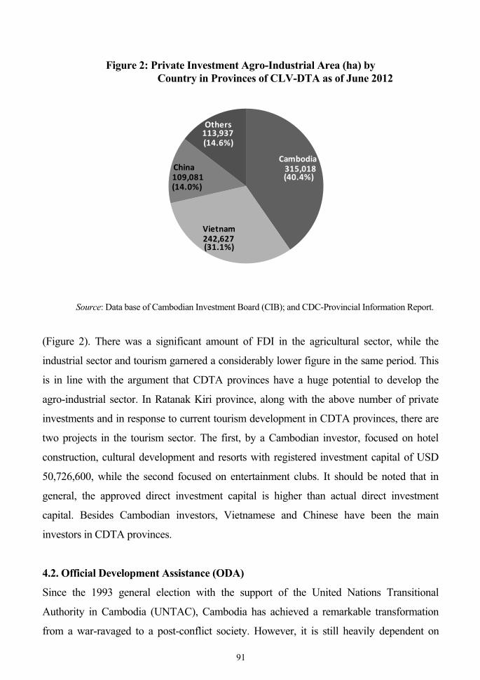
780,663ha, of which about 40% (315,018ha) was invested by Cambodians, 31%
(242,627ha) by Vietnamese, 14% (109,081ha) by Chinese, and the remainder about 15%
(113,937ha) invested by others, such as Indians, Malaysians, Koreans, Americans etc.,
Figure 1: Private Investment in CDTA Provinces as of June 2012
0 10 20 30 40 50 60
Total
Agro-industrial Plantation
Mines
Granite Processing
Tourism
Kratie
Mondol Kiri
Stung Treng
Ratanak Kiri
Source: Data base of Cambodian Investment Board (CIB); and CDC-Provincial Information Report.
90
Figure 2: Private Investment Agro-Industrial Area (ha) by Country in Provinces of CLV-DTA as of June 2012
Source: Data base of Cambodian Investment Board (CIB); and CDC-Provincial Information Report.
(Figure 2). There was a significant amount of FDI in the agricultural sector, while the
industrial sector and tourism garnered a considerably lower figure in the same period. This
is in line with the argument that CDTA provinces have a huge potential to develop the
agro-industrial sector. In Ratanak Kiri province, along with the above number of private
investments and in response to current tourism development in CDTA provinces, there are
two projects in the tourism sector. The first, by a Cambodian investor, focused on hotel
construction, cultural development and resorts with registered investment capital of USD
50,726,600, while the second focused on entertainment clubs. It should be noted that in
general, the approved direct investment capital is higher than actual direct investment
capital. Besides Cambodian investors, Vietnamese and Chinese have been the main
investors in CDTA provinces.
4.2. Official Development Assistance (ODA)
Since the 1993 general election with the support of the United Nations Transitional
Authority in Cambodia (UNTAC), Cambodia has achieved a remarkable transformation
from a war-ravaged to a post-conflict society. However, it is still heavily dependent on
91
315,018
242,627
109,081
113,937
Cambodia
Vietnam
China
Others
(40.4%)
(31.1%)
(14.0%)
(14.6%)
foreign aid in the form of official development assistance (ODA), which comprises both
grants and loans.
According to the Council for Development of Cambodia, loans normally account for
20-30% of total disbursements, while the remainder comes in the form of grants
(CDC-CRDB, 2011). The ODA finances physical infrastructure projects, supports human
resource development through improved health and education and upgrades technology.
Development assistance in the agricultural sector in Cambodia began in 1998 with
initial investment in the rice sector. Since that time, there have been numerous donor and
NGO projects primarily directed towards poverty alleviation, building infrastructure, and
developing local markets. According to the Council for the Development of Cambodia,
there are approximately 159 agricultural-related programs currently underway. Many
projects address constraints in irrigation systems, infrastructure and management, food
security and nutrition, and fisheries development. Investments in on-going development
activities currently total over USD 463 million with the largest amount coming from
multi-lateral institutions like the Asian Development Bank (ADB) and International Fund
for Agricultural Development (IFAD), and bilateral support from historically prominent
donors such as Australia, Denmark, France, Japan, and the United Kingdom (USAID,
2009).
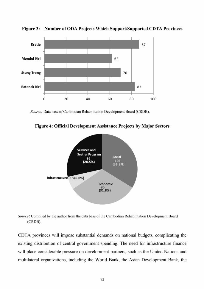
In CDTA provinces there were a total of 302 ODA projects: Kratie (87), Mondol Kiri
(62), Ratanak Kiri (83) and Stung Treng (70). Among these projects, 148 are on-going,
while 154 have been completed (Figure 3). The ODA projects in CDTA provinces are
comprised of 102 in the social sector, 96 in the economic sector, 18 in infrastructure and 86
in services and cross-sectorial programmes (Figure 4). The main sources of ODA in CDTA
provinces came from different development partners, including the United Nations and
multilateral communities such as the ADB, the World Bank, and the International Labour
Organization (ILO). European Union development partners include the UK, France,
Sweden, Denmark, Spain, Finland and Belgium. Bilateral development partners include
Japan, the United States, China, Australia, Korea, Switzerland and New Zealand (Figure 5).
With respect to the list of priority projects proposed by Cambodia in the Master Plan
for CLV-DTA, there are a total of 575 projects: 152, 122, 152, 149 proposed by Kratie,
Mondol Kiri, Ratanak Kiri and Stung Treng, respectively. Infrastructure requirements in
92
Figure 3: Number of ODA Projects Which Support/Supported CDTA Provinces
83
70
62
87
0 20 40 60 80 100
Ratanak Kiri
Stung Treng
Mondol Kiri
Kratie
Source: Data base of Cambodian Rehabilitation Development Board (CRDB).
Figure 4: Official Development Assistance Projects by Major Sectors
102
96
18
86
(33.8%)
(31.8%)
(6.0%)
(28.5%)
Infrastructure
Services andSectral Program
Social
Economic
Source: Compiled by the author from the data base of the Cambodian Rehabilitation Development Board
(CRDB).
CDTA provinces will impose substantial demands on national budgets, complicating the
existing distribution of central government spending. The need for infrastructure finance
will place considerable pressure on development partners, such as the United Nations and
multilateral organizations, including the World Bank, the Asian Development Bank, the
93
Figure 5: ODA Projects for DTA Provinces by Donors
Source: Compiled by the author from the Data base of the Cambodian Rehabilitation Development Board
(CRDB).
European Union, and bilateral partners, such as the USA, Japan, Australia, China, etc. The
estimated cost of the above projects is so high that the future successful implementation of
the CDTA development plan could be not realized without ODA participation.
According to the UNDP study, any reduction of ODA, which has contributed about
40% to the national budget, could have serious consequences concerning the country’s
development, especially in the social sectors, economic sectors and infrastructure (UNDP,
2009a).
5. OPPORTUNITIES & CHALLENGES FOR CDTA
DEVELOPMENT
The comparative advantages among CDTA provinces also suggest certain opportunities for
promotion of CDTA development. The CDTA provinces have a large land area with
fertile soil and a suitable climate for development of agro-industrial crops and a
processing agro-industry. There is an abundance of forest areas, large national
94
protected areas, forest protected zones, waterfalls and biodiversity which provide a great
potential for eco-tourism development. Another opportunity lies in the large number of
various untapped mineral resources (gold, iron ore, coal, gems, bauxite, copper, etc). These
areas are watered by many rivers, which create the potential of hydropower station
construction. Additionally, there is an enormous number of cultural and historic sites and
various ethnic cultures that provide huge potential for tourism development. Currently,
there are cross-border movements of trade, vehicles and people with accompanying
opportunities to facilitate cross-border investment and trade by simplifying and
streamlining regulations and procedures dealing with neighboring countries/partners. There
are good opportunities to attract private investment, including foreign direct investment and
domestic investment, as well as official development assistance, advanced technology
transfers and markets. Of course, peace and political stability will be strengthened in the
CLV-DTA.
Along with the above advantages and opportunities, there are also several challenges
facing the development of CDTA provinces: the shortage and degraded status of physical
infrastructure and facilities (including the road network), poor storage and warehousing
facilities, outdated information technology equipment and communication facilities, a lack
of clean water and an unreliable electricity supply. The irrigation system is also insufficient
to support paddy rice crops and other agro-industrial crops and plantation.
In addition, there is much concern about human resource development in the CDTA
provinces. The low level of education and skills is impeding the pursuit of these
complementarities. Workers in these provinces have low-level skills and general
knowledge and are unable to apply advanced technology and management practices to raise
productivity. Moreover, many provincial workers simply cannot meet the future
widespread needs of new agro-industrial investment projects.
In addition, these CDTA provinces have high levels of poverty, low population density
spread over widely dispersed residential areas and are remote from major economic and
population centers. In addition, education achieves only low levels of quality and, thus,
there is a low literacy rate. The people’s health status is also poor, including life expectancy
at birth, infant mortality and maternal mortality.
Although the development of CDTA provinces is expected to bring benefits to the
provincial people in terms of increased investment, trade and greater income-generating 95
opportunities, there are also undesired consequences for the people of CDTA provinces:
displacement of local communities, spread of communicable diseases, human trafficking
and illegal trade, and increased land prices. There will also be an environmental impact,
such as deforestation for rapid exploitation of natural resources in the provinces and
environmental degradation from pollution and waste disposal issues, etc.
The critical challenge is to achieve balanced development of all CDTA provinces and
the DTA member countries.
CONCLUSION
Cambodian development of triangle areas with Lao PDR and Vietnam and whole-hearted
cooperation among the three governments will realize the rich resource endowment
available to create an environment suitable for economic activities. Development will also
provide a significant geographic advantage and attract investors while contributing to the
promotion of growth and employment that will help to alleviate poverty.
The government has strong political and economic motivation to promote the
development of these CDTA provinces. To realize the benefits, long-term commitments by
government, private investors, the United Nations and multilateral and bilateral lending
agencies will be needed. To match efforts to boost the performance of CDTA provinces,
Cambodia needs to further promote a reduction in trade barriers, streamlining investment
regulations, improvements in tourism development, elimination of inefficiencies in physical
infrastructure (in particular, the road transport network), the irrigation system, energy,
telecommunications, better storage facilities, an improvement in education, vocational
skills training and the social welfare of its people. Moreover, Cambodia needs to encourage
more economic growth, produce more agro-industrial processing products to export instead
of raw products, facilitate road transport by implementation of cross-border transport
agreements (CBTA), simplify and streamline customs procedures (including
single-window administration) and risk management. Nevertheless, more information on
a development triangle is needed to increase awareness of possible business opportunities.
Furthermore, enhancing private and public-private sector participation will also be needed
to mobilize more financial resources to support development projects for the CDTA
96
provinces.
Finally, a special effort should be made to ensure that the poor and remote provinces in
the border areas of CDTA share in the benefits of DTA.
REFERENCES Asian Development Bank (2010) Strategy and Action Plan for the Greater Mekong