The Camden (Waiting and Loading Restrictions, Parking Places and Prescribed Routes) Experimental Traffic Order (No. 1) 2019 Notice is hereby given that the Council of the London Borough of Camden made the above mentioned order on 9 December 2019 under Section 9 of the Road Traffic Regulation Act 1984, as amended. The order will come into force on 6 January 2020. The general nature and effect of the order is as follows: NEW END, NW3; WELL ROAD, NW3; Vehicle prohibitions: On an experimental basis, vehicles will be prohibited from entering the following sections of New End at the points specified during New End Primary School term times on the days and between the times mentioned below. West to East arm – at the junction with Heath Street, between 7.30am and 9.30am, Mondays to Fridays North to South arm – at the junction with New End Square / Well Road, between 8am and 9am and between 3pm and 4pm, Mondays to Fridays Exemptions: Holders of a parking permit for the “CA-H” Hampstead Controlled Parking Zone will be automatically exempted from these restrictions. Holders of Disabled Persons’ Badges (Blue Badges) resident in the same Controlled Parking Zone area and residents of the restricted area with off-street parking may obtain a permit free of charge to exempt them from the prohibition. Permits may also be granted for other purposes, including taking disabled pupils to or collecting them from New End Primary and Heathside Prep Schools. Further information on how to apply for a permit can be found at www.camden.gov.uk/healthy-school-streets Pedal cycles, emergency vehicles and refuse collection trucks will also be exempt. Changes to parking places: Car Club bay at the northern end of the north to south arm of New End to be relocated to the south-east side of Well Road, south-west of the junction with Christchurch Hill Residents parking bay on the east side of the north to south arm of New End to be reduced in length by 2 metres at the northern end. Residents parking bay on the south-east side south-west of the junction with Well Road to be reduced in length by 3 metres at the north-eastern end. Implementation of loading controls: A prohibition on the loading unloading of vehicles to take effect 24 hours a day at the at the junction of the west to east and the north to south arms of New End. The Council will be considering in due course whether the provisions of the experimental order should continue in force indefinitely. Within a period of six months beginning with the date on which this experimental order comes into force or, if the order is varied by other orders or modified pursuant to section 10 (2) of the Road Traffic Regulation Act 1984 beginning with the day on which the variation or modification or the latest variation or modification came into force, any person may object to the making of an order for the purpose of such indefinite continuation. Any such objection must be made in writing, stating the grounds on which the objection is being made and sent to FREEPOST LBC TRANSPORT STRATEGY or by email to [email protected]
Transcript
The Camden (Waiting and Loading Restrictions, Parking Places and Prescribed Routes) Experimental Traffic Order (No. 1) 2019
Notice is hereby given that the Council of the London Borough of Camden made the above mentioned order on 9 December 2019 under Section 9 of the Road Traffic Regulation Act 1984, as amended. The order will come into force on 6 January 2020. The general nature and effect of the order is as follows: NEW END, NW3; WELL ROAD, NW3;
Vehicle prohibitions:
On an experimental basis, vehicles will be prohibited from entering the following sections of New End at the points specified during New End Primary School term times on the days and between the times mentioned below.
West to East arm – at the junction with Heath Street, between 7.30am and 9.30am, Mondays to Fridays
North to South arm – at the junction with New End Square / Well Road, between 8am and 9am and between 3pm and 4pm, Mondays to Fridays
Exemptions:
Holders of a parking permit for the “CA-H” Hampstead Controlled Parking Zone will be automatically exempted from these restrictions. Holders of Disabled Persons’ Badges (Blue Badges) resident in the same Controlled Parking Zone area and residents of the restricted area with off-street parking may obtain a permit free of charge to exempt them from the prohibition. Permits may also be granted for other purposes, including taking disabled pupils to or collecting them from New End Primary and Heathside Prep Schools. Further information on how to apply for a permit can be found at www.camden.gov.uk/healthy-school-streets
Pedal cycles, emergency vehicles and refuse collection trucks will also be exempt. Changes to parking places:
Car Club bay at the northern end of the north to south arm of New End to be relocated to the south-east side of Well Road, south-west of the junction with Christchurch Hill
Residents parking bay on the east side of the north to south arm of New End to be reduced in length by 2 metres at the northern end.
Residents parking bay on the south-east side south-west of the junction with Well Road to be reduced in length by 3 metres at the north-eastern end.
Implementation of loading controls: A prohibition on the loading unloading of vehicles to take effect 24 hours a day at the at the junction of the west to east and the north to south arms of New End. The Council will be considering in due course whether the provisions of the experimental order should continue in force indefinitely. Within a period of six months beginning with the date on which this experimental order comes into force or, if the order is varied by other orders or modified pursuant to section 10 (2) of the Road Traffic Regulation Act 1984 beginning with the day on which the variation or modification or the latest variation or modification came into force, any person may object to the making of an order for the purpose of such indefinite continuation. Any such objection must be made in writing, stating the grounds on which the objection is being made and sent to FREEPOST LBC TRANSPORT STRATEGY or by email to [email protected]
Copies of the order and other documents relating to this scheme may be obtained by contacting [email protected] or inspected at camden.gov.uk/recently-advertised-proposals or at London Borough of Camden, 5 Pancras Square, N1C 4AG. Peter Mardell Head of Parking Operations 12 December 2019
The Camden (Waiting and Loading Restrictions, Parking Places and Prescribed Routes) Experimental Traffic Order (No. 1) 2019
STATEMENT OF REASONS
REASONS FOR PROCEEDING BY WAY OF AN EXPERIMENT
The above order is made under s.9 of the Road Traffic Regulation Act 1984. It is expected that a decision whether or not to continue with its provisions, or as may be modified, indefinitely will be made after assessing the effect of the scheme over the course of 12 months from its commencement. The principle measures will be to prohibit vehicles from entering New End at the junction with Heath Street between 7.30am and 9.30am, and from entering the New End at its junction with New End Square / Well Walk between 8am and 9am and between 3pm and 4pm, on Mondays to Fridays during New End Primary School term times. There are minor changes to parking places in the vicinity of the latter junction associated with the construction of pavement build-outs designed to calm traffic. It is considered expedient to progress this scheme by way of an experiment with evidence being collected over the course of one year to determine its success balanced against any adverse effects which may appear. A report detailing the decision-making process behind the scheme, including analysis of prior consultation responses from residents and stakeholders, is appended to this statement.
9 December 2019
1
NON-KEY EXECUTIVE OFFICER REPORT
LONDON BOROUGH OF CAMDEN
WARDS: Hampstead Town
REPORT TITLE: Healthy School Street – New End School Area
REPORT OF: Head of Transport Strategy
FOR SUBMISSION TO: Director of Place Management
DATE: 24 May 2019
SUMMARY OF REPORT This report seeks approval for the implementation of a Healthy School Street timed road closure scheme on New End in the vicinity of New End School, NW3. The proposals also address the issue of high through-traffic volumes in the New End area. The recommendations link to Our Camden Plan as the scheme would contribute to creating clean, vibrant and sustainable places and encourage people to live healthy lives by making it easier to take part in physical activity such as walking and cycling. Local Government Act 1972 – Access to Information No documents that require listing were used in the preparation of this report. Contact Officer: Michelle Jamieson, Transport Strategy, London Borough of Camden, 5th Floor, 5 Pancras Square, LONDON N1C 4AG Tel: 020 7974 5537 Email: [email protected]
RECOMMENDATIONS That the Director of Place Management approves, subject to compliance with relevant statutory requirements, the following measures together, as described in the proposals section of this report under an Experimental Traffic Order (ETO):
1. Creating a ‘Healthy School Street’ (HSS) by restricting access to the part of New End closest to New End School at opening/closing times 8am to 9am and 3pm to 4pm, Monday - Friday during school term time only. The closure would be on the short stretch of New End, from the T-junction of New End and New End Square. This would be enforced using an Automatic Number Plate Recognition (ANPR) camera and relevant signage. Exemptions will be applied as set out in this report.
2. A build out of the footway at the above junction to create a safe crossing point for school pupils and pedestrians.
3. Removal of the car club bay near the T-junction. 4. Creating a timed road closure at the junction of New End and Heath
2
Street during the morning peak times of 7.30am to 9.30am only. This would be enforced by using an ANPR camera placed at the Heath Street and New End junction, and relevant signage. Exemptions will be applied as set out in this report.
5. Undertaking a robust period of monitoring during the 12 month ETO as
set out in this report, and use the data gathered to consult, as appropriate, on making the scheme permanent at the end of the 12 month trial, including any changes as required. Interim monitoring reports after 3 & 6 months will be undertaken and shared with key stakeholders.
6. To delegate to the Head of Transport Strategy authority for making any
minor changes to the scheme that may be required during the ETO period.
Signed:
Date: 24 May 2019
3
1. CONTEXT AND BACKGROUND 1.1 This report seeks approval for proposals for a timed road closure in the New
End area of Hampstead. The scheme is known as Healthy School Streets (HSS).
1.2 The HSS programme has been in operation in Camden since 2016. The aim of the programme is to provide children with the opportunity to travel to and from school in a safer environment by restricting vehicles during school opening and closing times. This meets the Mayor of London’s Healthy Streets objective of improving local environments by providing more space for walking and cycling, and better public spaces where people can interact. In addition, it meets a number of Camden’s Transport Strategy objectives. These include improving local air quality, encouraging healthy lifestyles by promoting walking, cycling or the use of public transport for school journeys and reducing car ownership, car use and motor traffic levels in the Borough.
1.3 New End School is a Community Primary School in the Hampstead Town Ward of the London Borough of Camden. There are currently 438 pupils attending between the ages of 3 and 11 years old. It is situated on Streatley Place, NW3 with the only vehicle access being from New End. New End is a one-way street between Heath Street and Well Road.
1.4 The school has participated in the TfL (Transport for London) STARS school travel planning project for the last nine years. Last year they achieved a Gold accreditation for their participation in the project.
1.5 In the latest School Travel Plan carried out in 2018 and uploaded on to the TfL STARS website, a number of road safety issues were raised by the school. These mainly concerned pedestrians’ (pupils) safety due to the congested road network around the school, insufficient pedestrian infrastructure in some locations and heavy parking activity. There have also been regular complaints made to both the school and Transport Strategy team, from local residents and councillors regarding bad driver behaviour and parking issues on New End near the school. There have also been reports of rat-running traffic on New End and other nearby streets.
1.6 Heathside Preparatory School will be affected by the scheme if it is implemented, although they have not contacted officers to request a scheme. Heathside Preparatory School is an independent school. It has three sites in this area – two in New End and one on Heath Street. The school does not participate in the STARS project, and has not recently submitted a school travel plan to the School Travel Plan Officer. Basic school information obtained from the STARS website states that there are 456 pupils ranging from the ages of 2-14 years old.
1.7 The TfL STATS 19 road traffic database shows that there have been two collisions in the New End area from October 2016-18. One close to the junction with Heath Street recorded as serious involving a collision with a
4
pedestrian and taxi. The other at the New End T-junction involving a car and goods vehicle noted as slight.
1.8 Air quality data obtained from the London Air website, based on
measurements made during 2013 show that NO2 pollution levels around New End School are around 40-43 ug/m3. We have placed our own air quality monitors in two locations near the school. Data from these can be reported on after August 2019.
2. PROPOSALS AND REASONS 2.1 To address some of the above issues, officers carried out a feasibility study
for a HSS scheme on New End. The feasibility study report is attached in appendix 1. As described in point 1.2 of this report, the HSS programme is in line with both Camden’s Transport Strategy, and the Mayor’s Healthy Streets objective. If the proposals are agreed, an Experimental Traffic Order (ETO) for 12 months is recommended.
2.2 Summary findings from the feasibility study showed the following:
Surveys and Observations:
On site observations carried out at both morning and afternoon peak times showed that many parents drop off/pick up children on New End, causing a build-up of traffic from the T-junction at the Southern end.
The most recent hands-up survey (table 1, below) carried out with pupils at New End School in April 2019 showed that 22% of children are driven to school. We do not have travel mode data for pupils at Heathside Preparatory School.
Table 1 – New End School Pupil Travel Modes
During school AM/PM opening/closing times, very high levels of traffic were observed on New End coming from Heath Street in an easterly direction. This was particularly pronounced between 7.30am and 9.30am, with around 300 vehicles recorded on New End heading
Mode of Travel Percentage of Pupils
Walking 45%
Scooting 4%
Cycling 1%
Active Travel Total 50%
Rail/Overground 2%
Tube 11%
Public Bus 15%
School bus/Taxi 0%
Public Transport Total 28%
Car/Motorcycle 20%
Car Share 2%
Car Total 22%
5
eastbound in that period, on a typical school day. At peak times during that period, around one vehicle every 12 seconds was recorded.
The graph in figure 1 overleaf shows the number of vehicles recorded on a typical school day on the section of New End heading Eastbound from the Heath Street junction. Table 2 below also shows the general traffic levels in the area on various streets surveyed during the feasibility study
The feasibility study calculated that around three-quarters of observed traffic in the morning peak appears to be predominantly through-traffic, rather than dropping off/picking up school children. That traffic then continues into Gayton Road and Well Walk, Flask Walk and Willow Road.
Table 2 – Example of a typical weekday traffic flows
Location AM peak 1.5 hour flow
typical weekday in term time
INTERPEAK flow
typical weekday in term time
PM peak 1.5 hour flow
typical weekday in term time
New End (western end) near junction with Heath Street
294 vehicles 08:00-09:30 hrs
68 11:45-13:15 hrs
110 vehicles 14:45-16:15 hrs
East Heath Road (eastbound)
950 vehicles 08:00-09:30 hrs
696 11:45-13:15 hrs
651 vehicles 14:45-16:15 hrs
East Heath Road (westbound)
429 vehicles 08:00-09:30 hrs
590 11:45-13:15 hrs
645 vehicles 14:45-16:15 hrs
Holford Road (southbound)
40 vehicles 08:00-09:30 hrs
0 11:45-13:15 hrs
13 vehicles 14:45-16:15 hrs
6
Figure 1: Graph showing spike in traffic flows on New End
2.3 Four options were explored during the feasibility study. The first included the
option described in point 2.7 (proposal B) for a two hour closure in both the morning and afternoon school opening and closing hours. Officers decided that given the particularly large traffic volumes in the morning peak, it would be advisable to firstly gauge opinion on that time period only. This could then be extended to the afternoon school run period if the monitoring during the ETO period, including stakeholder feedback, indicated that this should be explored further.
2.4 The other option explored in the feasibility study was as described for
proposal B, but extending the restricted zone to New End Square, Well Road and Grove Place. To enforce this large area of restricted traffic, three ANPR cameras would be needed. This option was deemed to be too costly and potentially difficult to implement. Therefore this option was not consulted on.
2.5 Proposal A - Restricting access to the part of New End closest to New
End School at school opening/closing times.
This proposal would create a timed road closure during New End Schools’ opening and closing times from 8am to 9am and 3pm to 4pm, Monday to Friday during school term time only. The closure would be on the short stretch of New End, from the T-junction of New End and New End Square by installing collapsible bollards there. A build out of the footway at the junction is also proposed to create a safe crossing point for school pupils and pedestrians as shown in the proposed layout (proposal plan A) in point 2.6. The existing car club bay at that location will be removed, and its relocation explored during the detailed design. Residents parked within the closure would be able to drive out via the southernmost part of New End and New End Square. However, they would not be able to drive back into the restricted zone at the restricted times. The consultation also offered this proposal using ANPR cameras, which would allow residents in the southernmost part of New
7
End to be fully exempt from the restriction. This is the recommendation for enforcing proposal A.
2.6 Proposal A plan with bollards
2.7 Proposal B - Create a timed road closure at the junction of New End and
Heath Street during the morning peak times of 7.30am-9.30am only
This would be enforced by using an ANPR camera placed at the Heath Street and New End junction, as shown in the proposed layout (proposal plan B) in 2.8. The proposed exemptions are described in point 2.9 of this report. This proposal is expected to deter traffic rat-running in the area, as it creates a restriction zone for drivers passing through and particularly prevents through-traffic in the morning peak. Parents of both New End School and Heathside Preparatory school would be more restricted from dropping off children in the morning, and this option would therefore encourage more sustainable travel modes to both schools.
8
2.8 Proposal plan B
2.9 For both proposals officers are proposing to exempt CA-H parking permit
holders, Blue Disabled Badge holders resident in the CA-H area, any residents in the restricted zone that have off-street parking and refuse vehicles. Further clarification regarding the legalities/data protection implications of this is being sought. Details regarding applying for these exemptions will be sent to relevant residents if the scheme is approved before implementation.
3. OPTIONS APPRAISAL
3.1 Implement as per the recommendations in this report. This is recommended as it is expected to address the issues identified in sections 1 and 2 of the report. Implementation under an Experimental Traffic Order (ETO) will allow a trial period to test the scheme ahead of any permanent measures being recommended.
3.2 Implement one of the proposals outlined from respondents to the consultation.
Those options are not recommended by officers for reasons set out in the consultation report in appendix 5.
3.3 Do nothing. However this is not recommended as it would not achieve the
benefits of a HSS. 4. WHAT ARE THE KEY IMPACTS/RISKS? HOW WILL THEY BE
ADDRESSED?
4.1 There is a potential risk of traffic displacement on to other roads in the area.
This was identified as a concern by some respondents in response to the consultation, as per section 6 and appendix 5 of the report. Traffic monitoring
9
will be placed in order to assess the impact on surrounding roads. This will be analysed after 3 & 6 months of the scheme being implemented. If the data shows high levels of traffic displacement further changes may be proposed to mitigate this, in consultation with residents and local stakeholders.
4.2 Officers have developed a monitoring methodology, as set out in this report,
to collect traffic data both pre and post implementation to assess the outcomes of the trial scheme period. We have already collected data at seven traffic monitoring sites to use as pre scheme monitoring, and 11 additional sites will be added to this with data collected before and after scheme implementation. Appendix 6 is a map of the monitoring sites with the Automatic Traffic Count (ATC), Turning Count and Air Quality (AQ) locations.
4.2.1 The post monitoring will take place 12 weeks after scheme implementation to be used for the 3 month reporting. Monitoring placed after 26 weeks will then be reported on after 6 months. Further monitoring towards the end of the 12 month ETO period will then be used for public consultation as to whether to make the scheme permanent or not.
4.2.2 In addition, air quality monitoring equipment has been in place at the southern
end of New End near Streatley Place, and at the New End T-junction since August 2018. Air quality monitoring has been placed outside Christ Church Primary School on Christ Church Hill since April 2019. Air quality monitoring needs to be in place for at least a year before it can be reported on. Therefore we will be able to report on the New End results during the ETO period, and the Christ Church School data can be reported on after April 2020.
4.3 A Data Protection Impact Assessment (DPIA) has been carried out for
Camden HSS schemes. This confirms that there are no risks in terms of data protection when using ANPR cameras for the schemes.
4.4 As we are exempting a relatively large amount of vehicles as listed in point
2.9, there is a potential safety risk for children and parents, as the signs will specify a ‘Pedestrian and Cycle Zone’. Officers will work with the school staff to make sure that children and parents are aware that some vehicles will still be travelling in the restricted zone, and pedestrians must be vigilant when crossing the roads.
4.5 A stage 1 & 2 road safety audit highlighted two risks relating to option A if it
was implemented with bollards. As we are recommending option A with ANPR cameras to enforce the closure, these comments are no longer applicable. The audit also highlighted two risks with option B relating to the risk of shunts due to hesitant manoeuvres at the junction. This will be mitigated by advance warning signage. Details of their locations will be decided during the detailed design phase. Another highlighted risk related to the risk of collisions due to a concentration of vehicles movements and on-street parking, and an increase in about-turn manoeuvres as through routes are suspended. Vehicle manoeuvres will be observed during the trial, however as New End is one way about-turn manoeuvres are unlikely.
10
5. LINKS TO THE CAMDEN PLAN 5.1 The proposals will assist in reducing car ownership and use, and incentivise
the use of sustainable, active travel modes. This meets the following objective of Our Camden Plan:
Clean, vibrant and sustainable places by playing a part in improving air quality, one of London’s biggest challenges.
Healthy, independent lives by making it easier to take part in physical activity such as walking and cycling.
6. CONSULTATION/ENGAGEMENT 6.1 On 20 June 2018 during the feasibility stage, officers held an initial meeting
with two Hampstead Town Ward Councillors and the head teacher of New End School. Heathside Preparatory School did not respond to the invite.
6.2 A public pre-consultation engagement meeting was held at New End School
in November 2018. All schools in the vicinity, residents groups and ward councillors were invited. The following attended; a representative from Flask Walk residents group, 7 local residents, 1 ward councillor, the deputy head of Christ Church School and the head of New End School.
6.3 A public consultation was carried out from 4 to 29 March 2019. 1,447 leaflets
were posted to residents in the consultation area shown in figure 3 overleaf.
Leaflets or emails were also sent to statutory groups and local groups as listed on the CINDEX database. The consultation was posted online on the Council’s ‘We Are Camden’ consultations website. Any interested party could submit a response online, regardless of their location. A copy of the consultation leaflet and questionnaire is attached in appendix 2. An equalities questionnaire was also included with all consultation leaflets posted, and the questions were included in the online consultation.
6.4 Figure 3: Map of consultation area (bordered with red lines):
11
6.5 A total of 178 valid responses were received. The public consultation respondents were classified as shown in table 4:
Table 4: Consultation respondent figures
Respondent type Number of responses
Percentage
Residents - inside the consultation area 131 74%
Residents - outside the consultation area 24 13%
School parent 11 6% New End School 1 1%
Christ Church School 1 1% Local/Statutory Groups 7 4%
Other 3 2%
TOTAL RESPONDENTS 178 100%
6.5.1 The numbers of responses to the questions on the consultation are shown in tables 5, 6 and 7: Table 5: Proposal A response figures
Do you agree with proposal A - restricting access to the part of New End closest to New End School at school opening/closing times?
Respondent type YES NO NO OPINION
Residents inside the consultation area 65 (50%) 55 (42%) 11 (8%)
Residents outside the consultation area 13 (54%) 11 (46%) 0 (0%)
School parent 3 (27%) 7 (64%) 1 (9%)
New End School 1 (100%) 0 (0%) 0 (0%)
Christ Church School 0 (0%) 1 (100%) 0 (0%)
Local/Statutory Groups 4 (57%) 1 (14%) 2 (29%)
Other 1 (33%) 2 (67%) 0 (0%)
TOTAL 87 (49%) 77 (43%) 14 (8%)
6.5.2 In summary table 5 shows that the majority (50%) of residents inside the
consultation area are in favour of proposal A. The totals show that 49% are in favour overall and 43% are against proposal A.
6.5.3 The respondents that answered yes to proposal A were also asked how they
would like it to be enforced. Of those that answered the question, 33 (37%) preferred bollards and 36 (41%) preferred ANPR cameras. 22% had no opinion on enforcement.
12
Table 6: Proposal B response figures
Do you agree with proposal B - create a timed road closure at the junction of New End and Heath Street during the morning peak times of 7.30am-9.30am, enforced by ANPR cameras?
Respondent type YES NO NO OPINION
Residents inside the consultation area 73 (56%) 57 (43%) 1 (1%)
Residents outside the consultation area 12 (50%) 10 (42%) 2 (8%)
School parent 4 (36%) 5 (45%) 2 (18%)
New End School 0 (0%) 1 (100%) 0 (0%)
Christ Church School 0 (0%) 1 (100%) 0 (0%)
Local/Statutory Groups 5 (71%) 2 (29%) 0 (0%)
Other 2 (67%) 1 (33%) 0 (0%)
TOTAL 96 (54%) 77 (43%) 5 (3%)
6.5.4 In summary table 6 shows that the majority of residents inside the
consultation area (56%) are in favour of proposal B. The totals show that 54% are in favour overall and 43% are against proposal B.
Table 7: Combining A & B response figures
Do you agree with combining Proposals A & B?
Respondent type YES NO NO OPINION NO RESPONSE
Residents inside the consultation area
51 (39%) 61 (47%) 10 (8%) 9 (7%)
Residents outside the consultation area
12 (50%) 7 (29%) 1 (4%) 4 (17%)
School parent 4 (36%) 6 (55%) 1 (9%) 0 (0%)
New End School 0 (0%) 1 (100%) 0 (0%) 0 (0%)
Christ Church School 0 (0%) 1 (100%) 0 (0%) 0 (0%)
Local/Statutory Groups 4 (57%) 0 (0%) 0 (0%) 3 (43%)
Other 1(33%) 1 (33%) 0 (0%) 1 (33%)
TOTAL 72 (40%) 77 (43%) 12 (7%) 17 (10%)
6.5.5 When asked about the combined proposals, 10% of responders chose to make no response. This anomaly has been reflected in table 7. It also shows
that combining proposals A and B has 3% more respondents opposing than supporting it.
6.5.6 Therefore the most popular proposal is proposal B with 54% of respondents
agreeing with it. If proposal B was implemented on its own however, this
13
would only potentially address the rat-running issues and may not benefit New End School.
6.7 Petition - During the public consultation period a petition against proposal B
was received petitioning the Council not to pursue proposal B. The petition stated that 81 residents from within the consultation area had signed the petition. In line with consultation policy to only count one response per household, officers counted 65 households that signed it, and one response from Hampstead Activity Nursery. Of the 66 objections to proposal B in the petition, 56 were responses that had not been included in the consultation figures as they had not responded directly to the consultation. Ten households had responded to the consultation directly. Therefore, if we were to count the petition in the same way as consultation responses and include them in the consultation response figures, a total of 113 out of 187 residents (60%) opposed proposal B. However, it should be noted that there is a difference between a public consultation and a petition. Through a public consultation the Council invites interested and affected members of the public and stakeholders to express their views on a particular matter – whatever these views may be. By contrast, a petition is offered to members of the public for signature, and subsequently submitted to the Council, by an individual or organisation unconnected with the Council, as a means to endorse a particular view. Whilst some petitioners may have previously seen the Council’s consultation material on the same topic, information presented in association with an invitation to sign a petition could be less complete. In relation to this specific petition, there is a lack of information regarding how many residents the petition was sent to, and what was shared with them. The petition responders who also responded to the consultation directly are counted in tables 5, 6 and 7. A copy of the petition letter is attached in appendix 4 of this report. The petition with signatures in appendix 3 is for
internal use only as it contains names and addresses of residents. The main concern of the residents who signed the petition is traffic displacement. This issue is commented on in appendix 5 of this report, and section 4 above.
6.8 Consultation comments – Of the 178 responses received, a total of 156
comments/suggestions accompanied them. One ward councillor, and two statutory groups and four residents groups commented on the proposals. Both New End School and Christ Church School commented on the proposals. The main concerns raised were traffic displacement, parking/access, pollution/idling and the impact for residents of Christ Church Hill/pupils at Christ Church School. These comments, along with officers’ responses are noted in appendix 5.
7. LEGAL IMPLICATIONS
7.1 London Borough of Camden’s legal team were consulted in the preparation of
the report and comments have been included within the body of the report. 8. RESOURCE IMPLICATIONS 8.1 There are no significant financial implications as a result of this proposal. The
estimated cost of the scheme is £70,000, which would fund the two ANPR cameras required and associated measures necessary to implement the
14
scheme. Funding has been secured from TfL under the Local Implementation Plan, project code 1020042 (School Travel Plan Engineering Measures) for 2019/20 financial year. Should the scheme be approved for implementation and the works overlap to 2020/21 then further funding will be made available from the same budget programme (HSS) to complete the scheme.
APPENDICES
Appendix 1 – feasibility study report Appendix 2 – consultation leaflet Appendix 3 – petition against proposal B with signatures (part II confidential appendices)
Appendix 4 – petition letter against proposal B Appendix 5 – consultation report Appendix 6 – monitoring survey locations map
REPORT ENDS
The Camden (Waiting and Loading Restrictions, Parking Places and Prescribed Routes) Experimental Traffic Order (No. 1) 2019 2019 No. 67
NEW END WELL ROAD
Fees and Charges (2014/
2018 No. 67 - ARTICLES
1
LONDON BOROUGH OF CAMDEN
TRAFFIC MANAGEMENT ORDER
2019 No. 67
The Camden (Waiting and Loading Restrictions, Parking Places and Prescribed Routes)
(No. 1) Experimental Traffic Order 2019 Made on 9 December 2019 Coming into force on 6 January 2020 ________________________________________________________________________ The Council of the London Borough of Camden, after consulting the Commissioner of Police of the Metropolis, in exercise of the powers conferred by section 9 of Road Traffic Regulation Act 1984 [1984 c. 27], and of all other powers thereunto enabling, hereby make the following order: 1. Citation and commencement
1.1 This order shall come into force on 6 January 2020 and may be cited as the
Camden (Waiting and Loading Restrictions, Parking Places and Prescribed Routes) (No. 1) Experimental Traffic Order 2019.
2. Interpretation
2.1 In this order the term "pedal cycle" has the same meaning as ascribed to it by the Traffic Signs Regulations and General Directions 2016 [S. I. 2016 No. 362].
2.2 “CA-H order” means the Camden (Parking Places) (CA-H) Traffic Order 2012
[L.B.C. No. 8]. 2.3 “disabled person’s badge” has the same meaning as in the Disabled Persons
(Badges for Motor Vehicles) (England) Regulations 2000 [S. I. 2000 No. 682]; 2.4 “New End permit” means a permit issued by the council for the purposes of
exempting a vehicle from the restrictions set out in Article 3 of this order. 2.5 “school term times” means the term dates of the academic year as published by
New End Primary School. 2.6 Any reference in this order to any enactment shall be construed as a reference to
that enactment as amended, applied, consolidated, re-enacted by or as having effect by virtue of any subsequent enactment.
2018 No. 67 - ARTICLES
2
3. Restrictions – prescribed routes 3.1 No person shall cause any vehicle to enter the west-to-east arm of New End at its
junction with Heath Street between the hours of 7.30am and 9.30am on Mondays to Fridays during school term times.
3.2 No person shall cause any vehicle to enter the north-to-south arm of New End at its
junction with the west to east arm of New End and New End Square between the hours of 8am and 9am and between 3pm and 4pm during school term times.
3.3 The council shall cause signage to be displayed indicating such restrictions at such
times and locations described in Articles 3.1 and 3.2 as prescribed or authorised under sections 64 and 65 of the Road Traffic Regulation Act 1984.
4. New End permit
4.1 The council may issue a permit in respect of specific vehicles for the purposes of exempting them from the restrictions set out in Article 3.
4.2 New End permits may take the form of an electronic record including the
registration mark of the vehicle. 4.3 Vehicles eligible to be issued with a New End permit shall include those; 4.3.1 in respect of which a residents permit has been issued under the provisions of the
CA-H order. 4.3.2 owned by persons who are be eligible to be issued with a residents permit issued
under the provisions of the CA-H order and to whom a Disabled Person’s Badge has been issued.
4.3.3 owned by persons who reside at properties to which vehicular access is only
possible by travelling along New End. 4.4 The council may issue a New End permit in respect of any other vehicle if it
considers it necessary for the vehicle to travel past the points and during the times specified in articles 3.1 and 3.2.
5. Restrictions on waiting and loading 5.1 Whilst this order remains in force, the provisions of the Camden (Waiting and
Loading Restrictions) (Civil Enforcement Area) Traffic Order 2012 [L. B. C. 2012 No. 1] shall have effect as though there was included in Schedule 2 to the Parent Order, the items set out in table 1 of the schedule to this order.
6. Revocation and designation of parking places 6.1 Whilst this order remains in force, the provisions of the Camden (Parking Places)
(Car Clubs) Traffic Order 2012 [L. B. C. 2012 No. 26] shall have effect as though;
2018 No. 67 - ARTICLES
3
6.1.1 there was omitted from the schedule to that order, the item set out in table 2 of the
schedule to this order 6.1.2 there was included in the schedule to that order, the item set out in table 3 of the
schedule to this order 6.2 Whilst this order remains in force, the provisions of the CA-H order shall have effect
as though; 6.2.1 there was omitted from schedule 1 to that order, the items set out in table 4 of the
schedule to this order; 6.2.2 there was included in schedule 1 to that order, the items set out in table 5 of the
schedule to this order. 7. Exemptions
7.1 Nothing in Article 3 shall apply in respect of; 7.1.1 anything done with the permission or at the direction of a police constable or traffic
warden in uniform; 7.1.2 a pedal cycle; 7.1.3 a vehicle being used by the police, fire brigade or ambulance service in an
emergency; 7.1.4 any person who causes any vehicle to proceed in accordance with any restriction
or requirement indicated by traffic signs placed pursuant to Section 66 or 67 of the Road Traffic Regulation Act 1984;
7.1.5 any vehicle in respect of which a New End permit has been issued; 7.1.6 any vehicle being used in the pursuance of the council’s statutory duty to collect
refuse.
8. Power to modify or amend this order
8.1 Pursuant to Section 10 (2) of the Road Traffic Regulation Act 1984, the Director of Regeneration & Planning, Supporting Communities Directorate, or any person authorised by him may, if it appears to him or such other authorised person essential in the interest of the expeditious, convenient and safe movement of traffic, or in the provision of suitable and adequate parking, or for preserving or improving the amenities of the area through which any road affected by this order runs, modify or suspend this order or any of the provisions in this order.
2018 No. 67 - ARTICLES
4
Dated this 9 December 2019
Peter Mardell Head of Parking Operations
2019 No. 67 - SCHEDULE 1
SCHEDULE TABLE 1
ITEMS INCLUDED IN SCHEDULE 2 TO THE CAMDEN (WAITING AND LOADING RESTRICIONS) (CIVIL ENFORCEMENT AREA) TRAFFIC ORDER 2012
ITEM NUMBER
STREET – SIDE OF STREET – LENGTH OF HIGHWAY RESTRICTED HOURS See
Schedule
NEW END
a) south and west sides; from a point intersecting the line of the eastern flank wall of no. 16 New End projected
northwards, to a point 2.2m north of the party wall of nos. 16 and 18 New End 1
b) south and east sides; from a point intersecting the line of the north-western flank wall of no. 57 New End
projected north-eastwards, to a point 5 metres north of the party wall of nos. 57 and 59 New End 1
TABLE 2 ITEM OMITTED FROM THE CAMDEN (PARKING PLACES) (CAR CLUBS) TRAFFIC ORDER 2012
ITEM NUMBER
STREET LENGTH OF HIGHWAY DESIGNATION
NUMBER
11790 NEW END north to south arm, west side; from a point 2 metres south of a point in line with the southern kerb line of New End (west to east arm), southwards for a distance of 5 metres
CC-112
2019 No. 67 - SCHEDULE 2
TABLE 3 ITEM INCLUDED IN THE CAMDEN (PARKING PLACES) (CAR CLUBS) TRAFFIC ORDER 2012
ITEM NUMBER
STREET LENGTH OF HIGHWAY DESIGNATION
NUMBER
13415 WELL ROAD south-east side; from a point 8.4 metres south-west of the south-western kerb line of Christchurch Hill, south-westwards for a distance of 5 metres
CC-112
TABLE 4 ITEMS OMITTED FROM SCHEDULE 1 TO THE CAMDEN (PARKING PLACES) (CA-H) TRAFFIC ORDER 2012
ITEM NUMBER
STREET LENGTH OF HIGHWAY CONTROLLED HOURS
3335 NEW END (north and south arms), the eastern side; from 3 metres north of a point opposite the southern flank wall of no. 71 New End, to 6 metres north of a point opposite the party wall of nos. 57 and 59 New End, for a distance of 41.3 metres
MONDAY – SATURDAY 9AM – 8PM
3401 WELL ROAD east side; from a point 4 metres south of the south-western kerb line of Christchurch Hill, southwards for a distance of 33 metres
MONDAY – SATURDAY 9AM – 8PM
2019 No. 67 - SCHEDULE 3
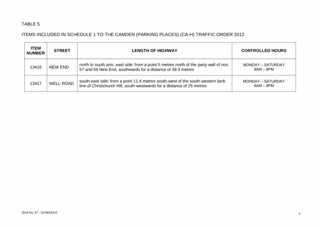
TABLE 5 ITEMS INCLUDED IN SCHEDULE 1 TO THE CAMDEN (PARKING PLACES) (CA-H) TRAFFIC ORDER 2012
ITEM NUMBER
STREET LENGTH OF HIGHWAY CONTROLLED HOURS
13416 NEW END north to south arm, east side; from a point 5 metres north of the party wall of nos. 57 and 59 New End, southwards for a distance of 39.3 metres
MONDAY – SATURDAY 9AM – 8PM
13417 WELL ROAD south-east side; from a point 11.4 metres south-west of the south-western kerb line of Christchurch Hill, south-westwards for a distance of 25 metres
MONDAY – SATURDAY 9AM – 8PM
Existing externally illuminated
one way signage to remain
HE
AT
H S
TR
EE
T
NEW END
T
H
E
M
O
U
N
T
Install ANPR camera onto
lamp column number 20
facing 'New End'
E
L
M
R
O
W
Relocate 'one way' sign to nearby fingerpost and stump
existing post to approximately 1.8m to ensure visibility
of adjacent sign face
RS03
RS04
RS05
RS02
RS05
Install wide base post with illumination. Install RS02 to post
maintaining 2.2m from the bottom of the sign to ground
level (ensure sign is folded until 6th Jan 2020).
Relocated 'one way' sign
Ensure sign is masked
until 6th Jan 2020
Ensure sign is masked
until 6th Jan 2020
Closure/ no-entry point
AmendmentsRev DateBy
Project
Drawing Title
DateScale
File Ref
Dwg Name
Drawing Location
Checked By
Drawn By
Drawing Number Rev.
New End - NW3
Healthy School Streets
Signage & Lining (for ETO)
Sheet 2 of 2
Healthy School Streets\New End\1200\002
NTS Nov 2019
T:\ Cptl_Schms\ 2018-19\ C&N\ STP Engineering Projects\ Healthy School Streets\ New End Scheme
MW
N
ANPR camera viewing angle
Key
Install signage (with a 2.1m sign
height clearance) onto lamp post
Existing signage on sign post
Transfer 'one way' sign, disconnect
electrical connection and cutdown
signpost to 2m height
Install signpost (with electrical
connection) and install RS02
(Healthy School Streets) sign to
signpost.
NOTES
Grey backed sign will be a folding design
For sign reference RS02, RS03,RS04
and RS05 please refer to sign schedule
Existing fingerpost with transferred
'one way' sign
For RS02 sign leaving 0.5m space from
the top of the signpost for future signage
N
E
W
E
N
D
W
E
L
L
R
O
A
D
N
E
W
E
N
D
S
Q
U
A
R
E
NE
W
E
ND
H
e
a
th
s
id
e
P
re
p
a
ra
to
ry
Reposition double yellow
lines and introduce double
kerb blips as shown
L
P
RS01
RS05
Folded closed until
06 Jan 2020
Ensure sign is on
reverse side to existing
sign on signpost
Closure/
no-entry
point
C
A
R
C
L
U
B
O
N
L
Y
5
m
W
E
L
L
R
O
A
D
C
H
R
I
S
T
C
H
U
R
C
H
H
I
L
L
2
5
m
W
e
a
t
h
e
r
a
l
l
L
o
d
g
e
A
g
r
i
s
t
C
o
t
t
a
g
e
2
m
2m of double yellow
lines replaced with
part of Car Club bay
3m of residents permit
holders bay replaced
with part of Car Club bay
L
P
RS05
G
R
O
V
E
P
L
A
C
E
W
E
L
L
R
O
A
D
Ensure sign on existing
lighting column
AmendmentsRev DateBy
Project
Drawing Title
DateScale
File Ref
Dwg Name
Drawing Location
Checked By
Drawn By
Drawing Number Rev.
New End
Healthy School Streets
Signing & Lining (for ETO)
Sheet 1 of 2
Healthy School Streets\New End\1200\001
NTS Nov 2019
T:\ Cptl_Schms\ 2018-19\ C&N\ STP Engineering Projects\ Healthy School Streets\ New End Scheme


![Camden journal (Camden, S.C.).(Camden, S.C.) 1852-06-01 [p ].](https://static.documents.pub/doc/80x56/619f257fbed7d658834197c1/camden-journal-camden-sccamden-sc-1852-06-01-p-.jpg)


