83
------ THE t:AtJYOfJS PLANNED UNIT DEVELOPMENT DEVELOPMENT STANDARDS MANDBOOK- Prepared by: ;;: CHRISTY • • • CORPORATION OCTOBER 26, 2020

------
THE t:AtJYOfJS
PLANNED UNIT DEVELOPMENT
DEVELOPMENT STANDARDS MANDBOOK-
Prepared by:
;;: CHRISTY • • • CORPORATION
OCTOBER 26, 2020

THE CANYONS PLANNED UNIT DEVELOPMENT
DEVELOPMENT STANDARDS HANDBOOK
Prepared for:
Six (6) Development, Inc.
8375 Fairway Ridge Court
Reno, Nevada 89523
Prepared by:
Christy Corporation, Ltd.
1000 Kiley Parkway
Sparks, Nevada 89436
(775) 425-4800
October 26, 2020

THE t:APJVOl'IS
TABLE OF CONTENTS
CHAPTER 1- INTRODUCTION AND IMPLEMNETATION ....... ........ ... ......... .................. ........ ........... 1-1
Purpose ........ .. ................. ....... ..... ... .......... ... ..... ..... ... .... .. .... .. ....... ...... ..... .... .... ........ ..... ......... 1-1 Community Vision ... .... ...... .. ...... .... ....... ..... .. .... ... .. .. ..... .... .......... .. ..... ..... .... .. ...... ... ... .... .. ...... .... ....... .... 1-1
Guiding Principles .......... ... .... .... ... ... .. ....... ... .. .......... ... ... .... ............... .. .. .. .... .... .... .. .. ... .. .... .. ....... . 1-3
Site-Sensitive Land Use Pattern .......... ......... ........... .......... ...... ... .... .. .... ....... ............................. . 1-3
Sense of Place, People Gathering Places and Walkability ....... ... .......... .......... .. .. ............ ... ....... 1-4
Use of Organic and Natural Materials ........................ ......... .. ................................. ....... .. ......... 1-4 Implementing the Vision ... ............................. ..... .. .......... ..... ... ........ ... .. .... .. .................. ............ 1-5
Project Description ......... ......... .. .... ...... .... ..... ..... ... ... ... .. .. ....... ..... ..... ... .......... .... ....... .... .. ..... .... ............ 1-5
Site Analysis .. ............. ...... .... .... ........ .... ... ............ ...................... ... .. ...... .. .... .. ............... .............. 1-7 The Canyons Land Plan ........ ... .................................... ..... ... .. ..... .. .. .. .. ........... ..... .... .. .... .. ....... .. ...... ...... 1-12
Canyon Creek ... .......... .... .. ....... ..... ....... ..... .. ..... .... ...... .. ....... ..... .. ..... .... ... ... ... .... .... ... .. .. ....... ...... .. 1-14
Canyon Crest ...... ........ ...... .... .... ... ....... ..... ... ..... .......... ........ ........... ... ...... ... ..... ...... ... .. ....... ....... .. . 1-16 Canyon Meadow .... ....... ...... ... ..... .. .. ... ... .. .. .. .... ... .......... ........ ... ... ........... .. ..... ........ ... .. .. .. ... ..... ... . 1-16
Canyon Estates .. .... ................ ... .. ................................. .. ...... ... ............... ... .. .... .... ..... ..... .. ......... . 1-17
Handbook Implementation ............. ......... .... ...... ........ .. .... ...................... ... ..... .. ...................... .. ... .... .. . 1-18
Binding Effect of Handbook .... ... ..... .. ................... ... ................................... ...... ... ... ...... ............. 1-19
Individual Project Approval s ... ......... ....................... ....................................... .. ... .... ... ..... ......... . 1-19
Deviations from Handbook Standards .... .. ........... ..................... ....... ... .... .. .. .... .. ............... ........ 1-19 Modifications to Handbook ................................. .... .. ..... .. .... .. ..... ....... ............. .. .......... ... ....... ... 1-19
Density .. .... .. ........ .......... .. .......... .... ............. .. ........ ................... ... ........... .. .... ..... .. .... ...... ...... . 1-20
Permitted Unit Transfers .... .. ... ............................... .. ............... ..... .. ........ ... ... .................. ..... .. ... 1-20
Affordable Housing ................................... ... .. .. .. ........ ... .......... ........... .. ... ...... ................ .... .... .... 1-20
CHAPTER 2 - DEVELOPMENT STANDARDS ............................ .... ........................ .... ...... ................. 2-1
Purpose and Compliance ......................... .. ....... ... ... ........... ..... ..... .... ... ........ ................ .... .. ...... .. .......... 2-1 Land Use Development Standards ............... ... ... ..... ... .. ... .... ..... ... .... ..... ...... .. .... ..... .. ....... ........ ... .... .... . 2-1
Residential Villages .......... ...... ......... ... ............ ... .. ..... .. ............... .. .. .... ... .... .. ................... ............ 2-1
Canyon Creek ... ........... .. .... ..... .... .............................. .. ..... .. .. ... ..... ...... .. .......... ... ...... .. .. .. ... .......... 2-2 Canyon Crest .. ..... .... ... .... .......... ..... .. .. ... .. ....... ... ..... .... ...... ..... .... ... .. ....... ......... ...... ..... ...... ....... .... 2-4
Canyon Meadow ........ .... ... .. ...... .. .. ... ........... ....... .. .... ..... ... ................. .... .... .. .. ...... ..... ..... ... ........ . 2-6
Canyon Estates .... ....... ..... ....... ..... ... ...... .. ... ...... ........ .. ...... .. .. ....... .. ... ..... .. .... .. .......... ... .. ..... ........ 2-8 Open Space ............ .. ......... ... ... ..... ... ................... .. .... ..... .. .. ........... .. ......... ....... ......... ... ... .... .. .. ... . 2-9
Permitted and Conditional Uses .. .. ............. .... ...... .. ...... .... .. ..... .. ... .... .... .. ... ... .. ..... .... .............. ... .... ..... 2-11
Roadway Standards .. .... ........... .. ..... ...... .... ..... ..... .. ... ..... ................ ........ ........ ... ... .... ..... ..... ..... .... ... .. ... . 2-13
Circulation Plan ... ........... ..................................... .. .. ... ..... .. ....... ........ ............. ..... .... .. .... ... .......... 2-13
Roadway Design ................ ...... .... .... ..... ... ................. .. .. ..... .... ........ .. ... .... .. ........ .. ... .... ....... ........ 2-13
Entry Features and Traffic Calming .. ..... ... .. ... .... ........ ....... .................. .. ... ............. .................... 2-15
THE t:APJVOJJS
CHAPTER 2 (continued):
Construction .. .. .... ...... .... ..... ..... ........... ........................... ....... ...... .. ... .. ..... ..... .... .. ......... .............. 2-15
Maintenance ... ......... ........... .. .... ..... ... ..... ......... ............................ ....... ... .... ....... .. ............ ... ... .. ... 2-15
Street Lighting ......... ................................... .... .. ....... ... ....... ....... ..... .... .. ........................................... 2-16 Roadways .. ..... .... ... ..... .... .... ..... .. .. .... .................. .... .. .......... .. ....... ... .. ........ .............. .. ..... ..... .. .... 2-16
Entries ......................... ... ...... .. .. ...... .......... .. ... ........ ........ ..... .. ....... ........ ....... ........ ........... ..... 2-18
Community Gateway ........... .. ..... ... ...... .... ....... ....... .... .... .. ...... ...... ................................ ...... .. ..... 2-18 General Requirements .... .. .. .... ................................. .... ... ... .. .... .... .... ... .. ...... .......... .. ... ... ... ...... .. . 2-18 Neighborhood Entries ..... .. ..... ...... ............ .. ..... .. ........... .. .... ... ...... .... ... .... ........ .. .......... .. .... .. ..... . 2-20
Trails .... .... ...... ...... .. .... .. ....... .. ... ... ..... .. ... .... ..... .. ..... ..... ... ..... ..... ... ...... ...... ............... .. ... ...... 2-22
Multi-Use Trails ... .......... ..... .. ... .. ..... .... ........ ... .... ....... .... ... .. ..... ... ... ............. ............ ....... ... ...... ... 2-22 Trail Access Points ......... ...... .. ..... ...... ..... ..... ...... .... .... ..... ......... .. .. ...... ... ...... ..... .. ..... ...... ..... .. ...... 2-25
Open Space ........................... ...... .. ..... ..... ...... ..... ....... ...... ..... ... ... .. .. .... ......... ..... ...... ... ... .............. 2-25 Open Space Amenities ............... .......... ....... ..... ... .. .. .... .... ....... ....... ...... .... ... .. ... .......................... 2-25
Urban/Wildlife Interface/Wild Horse Corridor ... .... .. .... .... ... .... ... .. ... ... ....... ......... .... .. ...... ...... ...... ....... 2-28
Grading ..... ............... ................... ............. ... .... ..... .. ... ... ... .... ..... .... ........ .. ........... ...... ... ... .. ... .. 2-29
Mailboxes ..... .. .... .. .............. ...... ....... .... ..... ........ ....... .. ... .... .. .... ....... .. .. ...... ............ ....... ...... .. ..... 2-30
CHAPTER 3 - SITE DESIGN AND ARCHITECTURAL STANDARDS ..................................................... 3-1
Overview ...... ..... .......... ...... ......... ................. ..... ......... ... ........ ........ ....... .... .... ...... .. .... .. ... .... ..... . 3-1
Site Planning Standards and Guidelines ......... ..... .................. .... .... ........ ..... .. ... .... ..... .. ........................ 3-2
Grading ...................... .. ....... ............... ... .... ... ... .... ..... .... ...... ............ ............ .. ...... ....... .. .... ..... 3-4 Landscaping ........ ....... .. .... ....... .. .. ................... .. .... ... ....... ......... ..... ....... ... .. ... ..... ...... .. ... ... .. .. .... ... 3-5 Project Entry ... ....... ........ ...... ..... .. .... ... ..... ..... ... ..... ... ... .... ....... ..... .. .................................... .. ...... . 3-8
Lighting ................................ ......... ..... ........ ...... .. ..... .... ....... .... ....... ....... ....................... .. ....... 3-9
Walls and Fencing ......................... .................. ...... .. ... ... ..... .... ... .. ...... .............. ........... ............... 3-10
Architectural Standards and Guidelines .... ... ............................... ..... .... ...... ....... .. .... .. ........ ...... ... .. ...... 3-12
Architectural Theme ........................ ........ ....... ......... ... ............ ..... ............. .... ... .......... .... .... ....... 3-12 Single Family Architectura l Standards ... ............ ....... ....... ..... ........ ... ...... ... ...... .. ... ...... ... .... ...... .. ...... .... 3-13
Design Ch aracterist ics ....... ... ... .. ..................... ...... .. .... ...... ......... ....... ........ .. ........... ...... .... ....... .. 3-13
Elevation Variat ions ............... ............... .. ........ ...... ... .. ... ..... ............... ........ ..... .. ......... ....... ....... .. 3-14
Windows .... .. ... .... ........ ..... ........ .. ......... ..... ........... .. .......... ........ ... .. .. .............. .... .... ..... ........... .. 3-15
Doors and Entries ...... ......... .. ....... .. .. ...... .. ............ ........ ........ .. ......................... ...... .............. .. .. .. 3-16 Garages .............. ...... .. ...... ...... ...... ........ ............ ...... ...................... ........ .. ... ... .... ...... ...... .... .... 3-17
Outdoor Living Spaces .... ..... ....... ..... ....... ........ ....... ... .... ...... .............. .. ....... .... ... ............... ... ...... 3-18
Exterior Paint and Materials ..... .... ... ... ....... ..... ... .... .. .. ... ...... .............. .. ....... ......................... ..... . 3-19 Finish Materials ........ .... .... ..... ..... ....... .. .... ........ ..... ... .. ............. .... ....... ........ .... ................... ..... ... 3-20
Roof and Mechanical Equipment .... ... ..... ........ ..... .. ........... ...... .................. ... .... ..... ......... .......... 3-21
Sustainability ...... ...... ...... ....... .... ..... .. ...... ........ ... ........... ...... .... ... ................ ........... .. ...... ....... ..... 3-21
Non-Residential Standards ....... .... .. .... .. .. ..... ... ................... .... ...... ........... ..... ........... .... .... .. ...... ............ 3-22
ii

THE t:APJVOf\IS
CHAPTER 4 - CONSTRUCTION, OPERATION, AND MAINTENANCE ................ ..... ...... ...... ..... .. ....... 4-1
Cl ean Job Site .. ...... ..... ........ ................. ... .................. ....... ... ... .. .. ... ........ ............ ... ..... ..... ... ...... ... .... 4-1
Protection of Vegetation During Construction ....... ...... ..... .... ... .. ........ ...... ...... ..... .... ..... ..... .... .... ..... ... 4-1
Temporary Protective Fencing ...... ..... .... ......... ... ....... ... ... ... .... .... .......... ...... .... ............ ... .............. ... .... 4-1 Erosion Control Plan and Storm Water Pollution Prevention Pl an (SWPP) .......... ... ... .. ..... ..... .... .. ... .. 4-1
Temporary Structures and Signs ........ .. ...... ..... ...... ...... .. ............ ... ........... ... ... ...... ... ...... ........ ....... ... .... 4-1
Model Home Complexes ...... .... .......... .... .. ... ....... .. ....... .... ...... ..... .... ... ...... .... ...... ... ... ................... ........ 4-2 Constru ction Yard s and Hours ........ ...... ... ... ...... .......................... ....... .... ....... ...... ....... .. ..... ....... ... ..... ... 4-3 General Constru ction Standa rd s ......... ...... ............. ......... ... .......... .. .... .. .... .. ................. ....... ... ......... .... 4-4
Common Area M aintenance ... ....... .......... .. .. ... ............. ....... ..... .... .... .. ... ............. ... ..... ....... .. ... ... .. .. .... . 4-4 General M aintenance Standa rds ... .... .. .... .... ........ .... ...... .... .. ...... .................. .. ... .... ...... .... ......... . 4-4
Private Open Space and Common Areas .. .... ....... .... .. .. .... .... .......... ......... ... ... ..... ........ ... ......... .. . 4-5
List of Figures:
Figure 1-1 Regional Context M ap .... ..... .. ... .. .. ..... ...... ... .. ........ ..... ... ... .. ........ ... ... ...... ......... .. .. .. ... ...... 1-6 Figure 1-2 Vicinity M ap ......................... .. ..... ....... ...... ...... .. ...... .. ............ .... ... .... ........ .... ... .. .... ... ..... .. 1-7 Figure 1-3 Slope An alysis .... .. .......... ... ... ....... ....... ...... ...... .. ...... ....... ....... ....... ........... .. .. ... ....... ...... .... 1-8 Figure 1-4 Sit e Photos .. ...... ....... .. .... ...... .. .... .. ...... ...... ..... ... ..... ......... ...... .... .. ........... .... .. ... .. ... ..... ...... 1-10 Figure 1-5 Site Ph otos ..................... .. .. .. .. ...... ........ ........... ... .... ...... .. .. ..... .................. ........ ..... ... ....... 1-11 Figure 1-6 Th e Canyons Concept ual Land Pl an ........ ... ... ... ..... ... ..... .. .. ..... .... ..... ....... ....... .. ..... .. ....... 1-15 Figure 2-1 Roadway Sections ... .... ..... ...... .... .............. ...... ... ..... ... .. .. ... ... .. ... ... ..... ...................... ...... .. 2-14 Figure 2-2 Community Gateway Concept ................ ..... ... ..... ... ..... .. ... ......... ...... .... ....... .. ........ .... .... 2-19 Figure 2-3 Typi ca l Neighborhood Entry Concept .... ....... ..... .... ..... ... .... ....... .. ..... .................... .. .. ..... 2-21 Figure 2-4 The Canyons Trail and Open Space Plan .. ..... .. ... .... ....... ...... .. .... ... ... .............. ... ..... .... .... 2-23 Figure 2-5 Trail Concepts ........................ .. ....... .... ...... ...... ....... .. ............. ........ .. ............... ....... .... ..... 2-24 Figure 2-6 Stone Cabin Concept ... .. ... ... ........ ............ .. .... .. ...... ... ..... ....... ..... .. ..... ...... ...... .. ........ ... .... 2-26 Figure 2-7 Open Space Am enity Con cepts ..... ... .. ...... ... ..... ... ....... .... ...... .. ... .. ... .. .. ...... .. ... .. ... .... ..... .. 2-27
List of Tables:
Tab le 1-1- Base PUD Density ... ..... ..... .. ......... ........................ ....... ...... ... .. ... .. ..... ............. .......... .. .. ..... 1-12 Table 1-2 - Required Open Space ... ...... ... ................. ....... ...... .... .... ... ... ........ ...... ... ....... ...... .... .. .... ..... . 1-13 Table 1-3 - Th e Canyons Land Use Summary .............. ... ... ..... ....... .. .. ... ... .. ........... ... .... ....... .. ... .. .... .. .. 1-18 Table 2-1 - Canyon Creek Development Standards ...... .. .. .... ......... .... .. .... .. ..... ... .... ... .... ........ ... ...... .... 2-2 Table 2-2- Canyon Crest Development Standards ... ..... ............ .... ......... ........... ... ......... ....... ...... ... .... 2-4 Table 2-3 - Canyon M eadow Development Standard s .......... ....... ............. ... ..... ..... ..... .. .................... 2-6 Table 2-4 - Canyon Est at es Development St anda rd s ...... .... .... ...... ........ ....... ... ... .... ..... ............... ....... 2-8 Table 2-5- Open Space Set backs and Density/Intensit y Req ui rements ....... .... .......... ..... ................. 2-10 Tab le 2-6 - Land Use M at rix ... ......... .... ... ............. .... ........ .... .. ... .... .. .... ... ........... ....... ....... ............ ... ..... 2-11 Table 2-7 - Streetsca pe Lighting Standards ....... ..... .. ...... ....... ........ ..... .. .... ...... .. ..... ... .. ......... .... ... .. .... . 2-17
ii i

1-1
1 INTRODUCTION AND IMPLEMENTATION
1.1 PURPOSE
The purpose of this Development Handbook is to provide for the orderly development of The Canyons
Planned Unit Development (PUD), while ensuring that the stated desired level of quality is achieved.
Because implementation of public and private improvements will occur in multiple phases over several
years, the standards and guidelines contained herein establish a common framework to guide individual
improvement plans. The development of The Canyons PUD is controlled and restricted by these
development requirements as well as by all applicable government codes and regulations. The Canyons
Design Review Committee (DRC) and the City of Reno shall enforce all provisions and standards including the
graphic and textual elements of this Development Handbook. This Development Handbook is not intended
to limit creativity or prevent variation necessary to respond to unique site conditions, but rather to generate
consistency and quality throughout The Canyons.
Improvement of public areas within The Canyons will be the responsibility of the developer, unless assigned
by agreement to other public or private parties. All improvements shall be designed consistent with these
standards and guidelines. Maintenance of public areas within The Canyons including trails, community
amenities, monuments, open space, decorative light fixtures, and landscape buffers will be the responsibility
of The Canyons Homeowners Association (HOA) unless assigned by agreement to other public or private
parties. Specific responsibilities for the improvement and maintenance of these areas are further addressed
in Chapters 2 and 3 of this Development Handbook.
1.2 COMMUNITY VISION
The Canyons embraces the natural beauty and indigenous characteristics of the site and adopts a Desert
Modernism/Contemporary theme. The overall vision of the community evolves from natural landforms and
site features including indigenous rock, sweeping views, wild mustangs, and the history of the area. The
community vision includes the use of natural materials found onsite to create community amenities that
blend with the natural landforms of the property. Rather than a mass-graded “production” approach to
development, new residences within The Canyons are located to respect natural landforms, afford
tremendous views, and blend with the natural surroundings.

1-2
Drawing from the natural beauty of the site, The Canyons sets out to create a sense of community that is
bound together through common design standards, similar styles, and innovative planning concepts. The
Canyons envisions a Desert Contemporary enclave that evokes a sense of place through unique amenities
such as gathering places, trails, and common community elements created from natural onsite materials.
The use of contemporary architecture sets The Canyons apart from existing neighborhoods to the west.
Ultimately, The Canyons will become the gateway to the eastern foothills creating a community like no other
found in the region.
The Desert Contemporary theme does not encourage typical suburban sprawl. Rather, the community
draws from organic design that provide less emphasis on sprawling yards and more focus on community
features, views, trails, and open space that provide residents areas to gather, recreate, and socialize. Similar
to some of Reno’s most cherished neighborhoods such as the Old Southwest and Caughlin Ranch, The
Canyons will include traditional design elements that have proven to be timeless such as incorporation of
duet homes, common driveways, and architectural elements that provide quality and innovative design.
The Canyons is a combination of modern contemporary design blended with the natural landscape including
the indigenous materials of the site. The community aims to be visually unobtrusive and embraces the
natural environment. From the dramatic canyon that frames the project entry to the natural beauty of the
wild horses that roam the eastern foothills, The Canyons aims to create a community that will make both
residents and the City of Reno proud.
An underlying concept of The Canyons vision is to create a community that appeals to a range of residents,
despite their phase in life. The community provides for a variety of home types including traditional single
family homes, duet attached single-family homes, and custom equestrian lots. These are unified with the
goal of providing a community that has a strong sense of place and encourages residents to interact with
each other.

1-3
The Canyons will evoke the style and charm of Desert Contemporary classics often found in areas such as
Spain, Palm Springs, Scottsdale, or Santa Fe. Contemporary architecture unique to the Truckee Meadows
encourages the use of natural materials and colors that blend with the awe-inspiring backdrop of the
project. Incorporation of community gathering spaces, interpretive trails that preserve the history of the
area, and the use of the natural indigenous rock to create amenities that blend with the environment will
serve to not only create a sense of place, but a true sense of community.
1.2.1 Guiding Principles
The Vision for The Canyons is to draw on the site’s natural features and history to create an identifiably
unique community that embraces a balance of residential units, preserves natural site features and open
space, accommodates wildlife, and protects views both to and from the eastern foothills. From this Vision,
three Guiding Principles have been established to guide the development, growth, and design of The
Canyons. Each principle serves as a foundation for the Vision that will create a desirable and successful
community.
1. Site-Sensitive Land Use Pattern.
2. A Distinct Sense of Place with People Gathering Places (Built-in and Walkability).
3. Use of Natural and Organic Materials.
1.2.2 Site-Sensitive Land Use Pattern
The Canyons PUD recognizes the scenic value of the project site and its unique features. This includes
topographic diversity and both onsite and off-site viewsheds. The land plan developed for The Canyons has
been designed to minimize grading and require site adaptive architecture which greatly reduces visual
impacts from development and preserves prominent site features such as knolls, drainages, and rock
outcroppings. Unlike a traditional mass-graded suburban subdivision, The Canyons includes a mix of
traditional, semi-custom, and custom homesites that adapt to the natural onsite landforms.

1-4
1.2.3 Sense of Place, People Gathering Places and Walkability
Place-making is one of the key components in creating a vibrant and balanced community. A sense of place
is fostered within The Canyons by creating human-scale environments in which the individual can feel both
comfortable and safe. The Canyons Land Plan organizes movement by providing connectivity between
various neighborhoods and community activity centers. Integration of people gathering places that contain
both passive and active recreation opportunities, gathering places such as a stone cabin constructed of
indigenous materials that can be used as an amphitheater, and areas where residents may sit and enjoy the
expansive views afforded from the site.
A 1.49± mile trail network (as detailed later in this Handbook) will provide connections between The
Canyons neighborhoods and the community amenities. Trails will connect to existing on and offsite facilities
and will extend throughout the project and to its boundaries, accommodating future connections as well.
Consistent with the community theme and vision, trails will incorporate the use of natural materials for
wayfinding and are purposely designed to not look manufactured or man-made.
1.2.4 Use of Organic and Natural Materials
The Canyons PUD recognizes that the natural beauty and features of the site are what truly sets the site
apart from other communities in the area. The property includes a dramatic canyon backdrop, majestic rock
formations, and a large knoll that affords views of Mount Rose, the Sierra Front, and the valley lights below.
The PUD envisions incorporating these natural features, not only as preserved areas but within the
development itself. This is accomplished by incorporating natural stone and timbers into even the smallest
details of the community. For example, rather than utilizing conventional wayfinding signs, the use of
natural rock to mark trails, create project entries, and identify project boundaries will occur in order to
maintain a natural appearance and blend The Canyons with the natural environment.
Amenities planned within The Canyons will include the use of native materials and will appear to be entirely
natural to the site. This includes benches constructed of onsite rock, trail markers that utilize indigenous
materials, walls constructed of natural stone, etc. A stone “cabin” will be located within the common area
and provides an amenity that children can explore, people can gather for events, and helps reinforce the
sense of community within The Canyons. Additionally, a naturally formed amphitheater that includes
seating constructed of natural rock will provide a dramatic backdrop for acoustic music performances,
neighborhood socials, and other community gatherings.

1-5
1.2.5 Implementing the Vision
The vision for The Canyons will be carried out through the guidance provided by the three overarching
principles. Its visual identity will be further defined and coordinated by the architectural, streetscape, and
landscape themes described in this Handbook. Innovative use of materials, methods of construction and
site planning proposed herein will also ensure the quality and character of the community as it develops
over time. This Development Handbook will be used by the City of Reno and the DRC as a guide for
reviewing individual projects within The Canyons.
1.3 PROJECT DESCRIPTION
The Canyons (APN#’s 145-010-06 and 07) consists of 81.01± acres located in the eastern foothills of the
Truckee Meadows. The site’s Virginia Range location affords views of the valley and South Meadows below
and is convenient to existing employment, shopping, and community facilities.
The PUD site area is characterized by rolling terrain that includes canyons, drainages, and significant natural
features including a prominent knoll. The area is home to wild horses that roam through the Virginia Range.
Natural features and wildlife corridors are a driving force of the community vision and design standards
contained herein.
Immediately west of the PUD boundary lies the Palisades project currently under development. Palisades
essentially forms the eastern boundary of Damonte Ranch and the South Meadows. The Canyons will create
the gateway to the eastern foothills and allows for a more innovative and sensitive approach to
development. The project is planned to allow for integration with the adjoining properties to the east and
north.

1-6
Figure 1-1 (below) depicts the location of The Canyons in context with the entire Truckee Meadows region
while Figure 1-2 (following page) depicts the site in context with the immediate areas that adjoin the PUD
boundary.
Figure 1-1 – Regional Context Map

1-7
Figure 1-2 – Vicinity Map
1.3.1 Site Analysis
As previously noted, the 81.01± acre PUD area includes a mix of terrain that includes areas well suited for
development nestled within areas that create dramatic backdrops, afford sweeping views, and provide
prime opportunities for valuable community open space.
The City of Reno Master Plan designates approximately 26.19± acres of the site as Open Space. The PUD
recognizes this and allows for the development of no more than 54.82± acres within the PUD boundary.
Additionally, the provisions of the City of Reno Hillside Ordinance will apply to all new development within
The Canyons. Thus, additional open space may be required with a future tentative map(s) based on the
amount of proposed disturbance, etc.
Density for The Canyons has been determined based on the underlying Single Family Neighborhood Master
Plan designation. Prior to the incorporation of PUD zoning, the site included a mix of SF-15 and Open Space
zoning. The PUD adopts the underlying densities associated with these designations and the basis of The
Canyons Land Plan.

1-8
Figure 1-3 (below) depicts a comprehensive slope analysis of The Canyons PUD area.
Figure 1-3 – Slope Analysis

1-9
A major drainageway, as defined by the City of Reno, traverses the southern portion of the PUD area. The
drainageway drains approximately 1,405± acres and is fed by the watershed above The Canyons in the
Virginia Range. The drainageway contains no identified wetlands or riparian vegetation. In fact, the
drainageway rarely has water flowing through it. Any disturbance to this drainageway as part of a future
tentative map(s) will require the review and approval of a Special Use Permit by the City of Reno, as detailed
in the following chapters.
Various small drainages exist onsite. However, these drainages rarely convey flows and simply open up for
sheet flow within the site itself. These drainages do not have significant hydrologic value and may be
altered with future development, subject to City of Reno standards.
As noted previously, there is a significant amount of indigenous rock onsite. This material dates back
thousands of years when the Virginia Range was originally formed. Although there are no significant
identified rock outcroppings, there are several rock formations that not only have scenic value but will serve
to become focal points of the community. The standards contained herein provide for the protection of
these scenic resources and require that new development incorporate the use of native materials to the
extent possible.
The Virginia Range is known for its herds of feral horses that graze along the eastern foothills. Unlike
conventional development, The Canyons embraces the feral horses within the development plan and views
the herds as a unique amenity rather than a hinderance to development. It is the intent of the PUD to keep
the feral horses that roam in this area safe, wild, and free.
As detailed later in this Handbook, feral horse migration corridors will be delineated with fencing on the
PUD’s northern and eastern property lines with a subsequent tentative map(s). This fencing will promote
the safety of future residents as well as the feral horses. In accordance with NRS 569.431, the Master
Developer or their assignee with erect a preconstruction fence to prevent the feral horses from entering the
construction area. Ongoing meetings and discussions with City staff and Federal agencies are supportive
with full acknowledgement that the fence lines may change with future development of adjoining properties
and must comply with Nevada law.
Figures 1-4 and 1-5 (following pages) depict the onsite conditions, views, and features located within The
Canyons PUD boundaries.

1-10
Figure 1-4 – Site Photos

1-11
Figure 1-5 – Site Photos

1-12
1.3.2 The Canyons Land Plan
The residential density allowed within The Canyons is derived
from the underlying Single Family Neighborhood (SF) Master Plan
designation previously assigned by the City of Reno. The SF
designation allows for densities as high as 7.26 dwelling units per
acre (i.e. SF-6). Underlying density of The Canyons PUD is based
on 2.9 dwelling units per acre, the equivalent of SF-15 zoning
which adjoins the site to the west.
Because the PUD area meets the thresholds of a Hillside
Development per the standards included in Section
18.12.1601.161 of the Reno Municipal Code, density reduction
factors are applied to the SF-15 base density to determine
allowed base density for The Canyons. This calculation is included
in Table 1-1 below:
Table 1-1 – Base PUD Density
Slope Category Area Within Range
Base Zoning Density
Density Reduction Factor
Unit Yield
0-15% 14.91± acres 2.9 du/ac None 43.24 15.1 to 20% 10.84± acres 2.9 du/ac 0.6 18.86 20.1 to 25% 13.69± acres 2.9 du/ac 0.2 7.94 25.1 to 30% 13.01± acres 2.9 du/ac 0.1 3.77 Greater than 30% 28.54± acres 2.9 du/ac No Density Allocation 0
TOTAL 81.01± acres ----- ----- 73 units
As depicted in Table 1-1, the maximum unit yield within The Canyons shall not exceed 73 units.

1-13
The Canyons PUD will also conform to the standards set forth in Section 18.12.1607 of the Reno Municipal
Code as it relates to required open space. Required open space is calculated in Table 1-2 below.
Table 1-2 – Required Open Space
Slope Category Area Within Range Minimum Required Open Space
Required Open Space Yield
0-15% 14.91± acres None None 15.1 to 20% 10.84± acres 25% 2.71± acres 20.1 to 25% 13.69± acres 50% 6.85± acres 25.1 to 30% 13.01± acres 75% 9.76± acres Greater than 30% 28.54± acres 100% 28.54± acres
TOTAL 81.01± acres ----- 47.86± acres
A total of 47.86± acres of dedicated open space is required within The Canyons PUD. Compliance with the
open space standard and requirements set forth by Section 18.12.1607 of the Reno Municipal Code shall be
demonstrated in any future tentative map. This includes the potential for additional open space
requirements should the disturbance of 30% or greater slopes occur. Required open space may be included
within development areas identified on The Canyons Land Plan through the use of clustering, common open
space, etc.
Although The Canyons consists of only 73 units, the Land Plan introduces a diversified mix of residential
densities within the PUD. The Land Plan envisions an enclave approach to development and allows for
flexibility in design to accommodate a multitude of unit types. Four distinct villages are identified within the
land plan forming individual neighborhoods that are unified through common design elements, amenities,
and pedestrian connections.
The four distinct villages included within The Canyons are; Canyon Creek, Canyon Crest, Canyon Meadow,
and Canyon Estates. These villages are summarized herein. Specific design standards for units permitted
within each village is included within the following chapters. Figure 1-6 (following page) depicts The
Canyons Land Plan, including proposed village boundaries.

1-14
Figure 1-6 – The Canyons Conceptual Land Plan

1-15
1.3.3 Canyon Creek
The Canyon Creek village is generally located within the southwestern portion of the PUD area. Canyon
Creek is characterized by a major drainageway that essentially splits the village. With the exception of the
drainageway, Canyon Creek includes relatively flat terrain (less than 15% slope) and is well suited for
suburban development at densities comparable to the adjoining Palisades project to the west. As such,
Canyon Creek will include a minimum lot size of 7,500 square feet with lot sizes ranging up to 15,000 square
feet.
Canyon Creek serves as the “front door”
to The Canyons via an extension of Claim
Jumper Way. A grand entry (as detailed
in Chapter 2) that highlights the natural
canyon backdrop will be located within
Canyon Creek and will welcome residents
and guests to The Canyons, providing a
distinct separation from existing
development to the west.
As with all villages within The Canyons, design standards are intended to reduce the amount of onsite
grading and allow for innovative approaches to site development. Although the village area is relatively flat,
the use of common driveways to serve multiple homes may be permitted to reduce disturbance, protect
viewsheds and add visual interest.
As a unique amenity to the community, a small retail component may be included within a privately
operated community clubhouse within Canyon Creek or the adjoining common area. As detailed in Chapter
2, retail uses are limited in size and scope and are envisioned for uses such as a small coffee shop, wine bar,
or small café directly serving the residents and surrounding area. The intent of the retail use is to provide a
walking destination for residents to gather, strengthening the sense of place and community.

1-16
1.3.4 Canyon Crest
Canyon Crest is comprised of three smaller village areas
that are envisioned to include a mix of semi-custom
homes that take advantage of the sweeping site views.
Residences within Canyon Crest will adapt to the site
topography and will include stepped lots with hillside
adaptive architecture (i.e. walk-out basements and walk-
up entries). This will greatly reduce site grading and allows
for innovative and unique architecture. Similar to Canyon
Creek, Canyon Crest may provide opportunity for unique
design elements such as common driveways/courts with
clustered housing to reduce overall grading disturbance.
A community clubhouse (as previously described) may be located within Canyon Crest. Lot sizes within
Canyon Crest are expected to range from 10,000± square feet up to 20,000 square feet.
1.3.5 Canyon Meadow
Canyon Meadow is envisioned as a unique enclave within The
Canyons and will include the ability to accommodate duet
units. This single family attached product type is appealing to
those that wish to have less yard maintenance, etc. Duets will
be clustered to preserve open space within the village itself.
These common areas can include community amenities and
landscaping that afford residents the privileges or landscaped
yard areas, community gardens, etc. without the maintenance
burden.
Depending on final village design, a sub-association may be implemented within Canyon Meadow for the
ongoing maintenance of private amenities. Clustering of units is a key component of the Canyon Meadow
design. This not only adds to open space but reduces the overall site disturbance and visual impact. As
such, 1,500 is the minimum required lot size within Canyon Meadow. However, the open space and
common areas that surround the units will provide the visual appearance of much larger homesites.
1-17
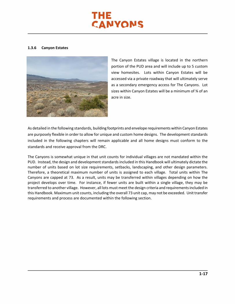
1.3.6 Canyon Estates
The Canyon Estates village is located in the northern
portion of the PUD area and will include up to 5 custom
view homesites. Lots within Canyon Estates will be
accessed via a private roadway that will ultimately serve
as a secondary emergency access for The Canyons. Lot
sizes within Canyon Estates will be a minimum of ¾ of an
acre in size.
As detailed in the following standards, building footprints and envelope requirements within Canyon Estates
are purposely flexible in order to allow for unique and custom home designs. The development standards
included in the following chapters will remain applicable and all home designs must conform to the
standards and receive approval from the DRC.
The Canyons is somewhat unique in that unit counts for individual villages are not mandated within the PUD. Instead, the design and development standards included in this Handbook will ultimately dictate the number of units based on lot size requirements, setbacks, landscaping, and other design parameters. Therefore, a theoretical maximum number of units is assigned to each village. Total units within The Canyons are capped at 73. As a result, units may be transferred within villages depending on how the project develops over time. For instance, if fewer units are built within a single village, they may be transferred to another village. However, all lots must meet the design criteria and requirements included in this Handbook. Maximum unit counts, including the overall 73 unit cap, may not be exceeded. Unit transfer requirements and process are documented within the following section.

1-18
Table 1-3 – The Canyons Land Use Summary Note: Villages are color-coded to Conceptual Land Plan included in Figure 1-6. Village Area Minimum Lot Size Canyon Creek 9.95± acres 7,500± square feet Canyon Crest 9.4± acres 10,000± square feet Canyon Meadow 2.14± acres 3,000± square feet Canyon Estates 7.53± acres 32,600± square feet VILLAGE SUBTOTAL 29.02± acres ----- Open Space 51.99± acres ----- PUD TOTAL 81.01± acres -----
Development standards, regulations, and requirements for all land uses are included in Chapters 2 and 3 of this Development Handbook. Overall units within The Canyons may not exceed 73. Density within The Canyons will be clustered within the various villages shown on the Conceptual Land Plan. Consistent with the underlying City Master Plan designation of Single Family Neighborhood, the total gross density within the PUD boundaries may not exceed that permitted by the SF-15 zoning district (73 units).
1.4 HANDBOOK IMPLEMENTATION
1.4.1 Definitions
For purposes of implementation of this Development Handbook, the definitions related to land use included in the City of Reno Municipal Code shall be adopted. For clarification purposes, the following definitions are clarified herein:
• Administrator – The City of Reno Community Development Director or their designee.
• Master Developer – Six (6) Development, Inc. and/or its designee.
• Guest Builder – Companies and/or individuals other than the Master Developer applying for entitlements and/or building within an individual phase.

1-19
1.4.2 Binding Effect of Handbook
Pursuant to NRS 278A.520 and NRS 278A.570, this Handbook cannot be modified or otherwise impaired by
the action of the City without the consent of the Master Developer and any required landowner, except as
specified in NRS 278A.410. Pursuant to NRS 278.0201 the ordinances, resolutions or regulations applicable
to The Canyons and governing the permitted uses of it, the density and standards for design, improvements
and construction on it are those in effect at the time of adoption of the Planned Unit Development and this
Handbook.
1.4.3 Individual Project Approvals Individual projects within The Canyons shall be reviewed and approved by the DRC and subject to review processes included in the City of Reno Municipal Code. This includes tentative subdivision maps, special use permits, variances, etc. Although new development shall be reviewed in context with the standards and requirements of this Handbook, all statutory public review requirements set forth in NRS and the Reno Municipal Code shall remain in full effect and shall be applied to new development requests within The Canyons. 1.4.4 Deviations from Handbook Standards All development within The Canyons shall comply with the standards and requirements of this Handbook. However, it is recognized that unusual or unique circumstances may arise from time to time. Therefore, deviations from standards contained herein, not to exceed 20%, may be granted on a case by case basis with the approval of the Administrator. Additionally, any deviation from the standards of this Handbook must also be approved by The Canyons Design Review Committee (DRC). The DRC, and its organizational characteristics, shall be established with The Canyons covenants, conditions, and restrictions (CC&R’s) as proposed by the Master Developer and approved by the Reno City Attorney’s Office. 1.4.5 Modifications to Handbook Upon adoption and recordation, the standards and requirements outlined within this Handbook shall take full effect. Any modification to these standards, land uses, densities, etc. that exceed 20% shall require the review by the City of Reno Planning Commission and approval by the Reno City Council. Modifications to this Handbook or the PUD boundary shall be subject to the review of a Zone Change and the associated requirements and public review defined within the Reno Municipal Code.

1-20
1.4.6 Density Gross density within The Canyons PUD area shall not exceed 0.90 dwelling units per acre. Density within an individual planning area/village may not exceed that defined within Table 1-1. or as further restricted through the provisions and requirements of this Handbook. The maximum number of units within The Canyons PUD may not exceed 73. The Master Developer shall be responsible for providing a running-total of units to be provided with each individual tentative map request(s) in order to demonstrate compliance with this standard. 1.4.7 Permitted Unit Transfers The Canyons Conceptual Land Plan, depicted in Figure 1-6, designates several village areas for residential
uses at varying densities (as regulated herein). Permitted units may be transferred from one village area to
another under the following conditions:
(1) Permitted units may be transferred from one village to another within The Canyons PUD. No such
transfers will be allowed to or from development areas outside of the defined PUD area.
(2) Before and after each transfer, the total permitted units for all land use areas shall not exceed 73;
densities for residential uses may not be exchanged with or converted to non-residential uses.
(3) Any proposed density transfer shall be subject to the approval of the Master Developer.
1.4.8 Affordable Housing
The PUD will assist the City of Reno in providing affordable housing through the following measures: (1) Accessory Dwelling Units (ADUs) and attached products are an allowed use in The Canyons to provide affordability options. (2) The Master Developer will enter into an Agreement with the City of Reno to make a donation to the City
of Reno or City or designee (as appointed by the City Council) for affordable housing with each unit sold.
This shall further be conditioned with each tentative map, giving the City flexibility on providing affordable
housing (reference The Canyons Affordable Housing Agreement).

2-1
2 DEVELOPMENT STANDARDS
This chapter provides development standards for each of the villages depicted within The Canyons PUD,
as well as for dedicated open space areas.
PURPOSE & COMPLIANCE
The purpose of Chapter 2 is to set regulatory requirements for the various villages and uses located within
The Canyons development. These requirements include standards for land use, density/intensity, and for
the design of rights-of-way, landscape buffers, trails, entries, etc. All development shall comply with the
text, policies, standards, and associated tables and exhibits of this Development Handbook. Where a
conflict exists between these development standards and the City of Reno Municipal Code, the standards
contained herein shall apply. Where this Development Handbook remains silent, the provisions and
definitions within the City of Reno Municipal Code Title 18 shall apply.
LAND USE DEVELOPMENT STANDARDS
Residential Villages
The residential land uses within The Canyons allow a variety of housing densities and types including
conventional suburban development, semi-custom and custom homes, and duets (attached single family).
Additionally, a community clubhouse that incorporates limited retail/mixed use is permitted. Four
residential villages are identified and described in Chapter 1 and depicted on The Canyons Conceptual
Land Plan. Standards for development within these villages are defined herein.
Permitted uses and those uses requiring a Site Plan Review and/or Special Use Permit are contained in
Table 2-1, Land Use Matrix. The Design Review Committee (DRC) and the Administrator shall determine
the appropriateness of uses not specifically outlined in Table 2-1. Park facilities are a permitted use in all
residential land uses.

2-2
Canyon Creek
Canyon Creek allows for single-family residential units
at suburban densities comparable to adjoining
projects. Canyon Creek is envisioned to include a mix
of single-and two-story units on padded lots. Mass
grading of development pads may occur within Canyon
Creek subject to the grading provisions of this
handbook.
The drainageway that traverses Canyon Creek
shall be maintained. Any disturbance or
rerouting of this drainageway shall be subject to
the standards contained herein and subject to
the review and approval of a Special Use Permit
(SUP) by the City of Reno.
Table 2-1 – Canyon Creek Development Standards
VILLAGE CANYON CREEK
DESCRIPTION Canyon Creek is intended to provide single family detached homes in a variety of lot
configurations and styles. Typical housing types include standard single family detached at
suburban densities. Duets may be permitted if they comply with the architectural style and
character of the surrounding product types.
BUILDING INTENSITY
Lot Size (minimum) 7,500 square feet Note: Building height shall be
defined per the Reno Municipal
Code. Architectural elements
exceeding 35’ may be permitted
with DRC review. Duet lots may
be reduced to 3,750 sq.ft.
Minimum Lot Width 65 feet
Building Height 35 feet (2 stories) maximum

2-3
VILLAGE CANYON CREEK
BUILDING SETBACKS FROM PROPERTY LINES
FRONT YARD SETBACKS Note: Homes that include both
front and side entry garages shall
maintain a minimum setback of
15 feet to the side load garage
and 20 feet to the front load
garage.
Detached casitas or ADU shall
maintain a minimum front
setback of 15 feet.
To main structure w/
Front Entry Garage
15 feet minimum
To Porch 10 feet minimum
To Front Entry Garage
(from public ROW)
20 feet minimum
To Side Entry Garage 15 feet minimum
SIDE YARD SETBACKS
Interior Side Yard 10 feet minimum
Side Yard Adjacent to
Street
10 feet minimum
REAR YARD SETBACKS Use Easements Permitted – see Notes below
To Main Structure 20 feet minimum
To Deep Recessed
Garage
10 feet minimum
BUILDING PROJECTIONS Refer to Reno Municipal Code Chapter 18.12
ACCESSORY USES
Accessory uses shall be permitted pursuant to Reno Municipal Code Section 18.08.203
ACCESSORY DWELLING UNITS (ADU)
Accessory Dwelling Units shall be permitted per the standards included herein.
NOTES
Exclusive use easements (to the benefit of individual residences adjoining common areas) that allow for use of
common area/open space, may be incorporated within Canyon Creek and applies to rear yards. The width of
these easements may vary and shall not exceed 20-feet.

2-4
Refer to example of Exclusive Use Easement above, as permitted for homes with rear yards adjoining
common area/open space. Widths will vary based on factors such as topography, site suitability,
viewsheds, etc.
Canyon Crest
Canyon Crest is envisioned to include a mix of semi-
custom homes. Homes within Canyon Crest will be
designed around the natural site topography and may
include a mix of flat and stepped homesites, including
both walk-out and walk-up designs. To the extent
possible, stepped foundations and hillside adaptive
architecture shall be utilized to avoid large cut/fill slopes
(refer to Grading standards contained herein).
Table 2-2 – Canyon Crest Development Standards
VILLAGE CANYON CREST
DESCRIPTION This village is intended to provide semi-custom detached single family homes. The
use of hillside adaptive architecture including walk-out basements, stepped
foundations and split-level floorplans is highly encouraged in areas where it can
reduce site grading.
BUILDING INTENSITY
Lot Size 10,000 square feet minimum Note: Homes that include walkout
basements or walk-up architecture
may include 3 stories.
Building height shall be measured
Minimum Lot Width 60 feet
Building Height 35 feet (2 stories) maximum for flat lots
40 feet maximum (3 stories) for stepped lots

2-5
VILLAGE CANYON CREST
as defined in the Reno Municipal
Code.
BUILDING SETBACKS FROM PROPERTY LINES
FRONT YARD SETBACKS Note: Homes that include both
front and side entry garages shall
maintain a minimum setback of 15
feet to the side load garage and 20
feet to the front load garage.
Detached casitas or ADU shall
maintain a minimum front setback
of 15 feet.
To Main Structure w/
Front Entry Garage
15 feet minimum
To Porch 10 feet minimum
To Front Entry Garage
(from public ROW)
20 feet minimum
To Front Entry Garage
(from private ROW)
15 feet minimum
To Side Entry Garage 15 feet minimum
SIDE YARD SETBACKS
Interior Side Yard 10 feet minimum
Side yard to Adjacent
Street
15 feet minimum
REAR YARD SETBACKS
To Main Structure 20 feet minimum
To Deep Recessed
Garage
15 feet minimum
ACCESSORY USES
Accessory uses shall be permitted pursuant to Reno Municipal Code Section 18.08.203
ACCESSORY DWELLING UNITS (ADU)
Accessory Dwelling Units shall be permitted per the standards included herein.

2-6
Canyon Meadow
Canyon Meadow will include a mix of attached single family
duet units. These units include small lots requiring less
maintenance but shall be surrounded by landscaped common
area and amenities that give the visual appearance of a larger
homesite.
Table 2-3 – Canyon Meadow Development Standards
VILLAGE Canyon Meadow
DESCRIPTION Canyon Meadow includes duet units clustered amongst common areas and
community greens. A sub-association may be incorporated for Canyon Meadow
should private streets and/or community amenities be incorporated.
BUILDING INTENSITY
Lot Size 1,500 square feet minimum Note: Building height shall be
defined per the Reno
Municipal Code. Architectural
elements exceeding 35’ may
be permitted with DRC review.
Minimum Lot Width 30 feet minimum
Building Height 35 feet (2 stories) maximum
LANDSCAPING
Refer to Section 2.3.4 for common area landscape requirements.
BUILDING SETBACKS FROM PROPERTY LINES
FRONT YARD SETBACKS
To Main Structure w/
Front Entry Garage
10 feet minimum
To Porch 10 feet minimum
To Front Entry Garage
(from public ROW)
18 feet minimum
To Side Entry Garage 10 feet minimum
SIDE YARD SETBACKS Use Easements Permitted – see Notes below Note: A minimum of 10 feet of

2-7
VILLAGE Canyon Meadow
Interior Side Yard 0 or 5 feet minimum separation between duet
structures is required. Exterior Side Yard 5 feet minimum
Side yard to Adjacent
Street
10 feet minimum
REAR YARD SETBACKS Use Easements Permitted – see Notes below
To Main Structure 10 feet minimum
BUILDING PROJECTIONS Refer to Reno Municipal Code Chapter 18.12
ACCESSORY USES
Accessory uses shall be permitted pursuant to Reno Municipal Code Section 18.08.203
NOTES
1. Exclusive use easements allowing for use of adjoining parcel may be incorporated by individual developers,
allowing use of the adjoining parcel as a side yard for the residence. Easement area may vary and shall be
called out on subsequent tentative map(s) and recorded with final map.
2. Exclusive use easements (to the benefit of individual residences adjoining common areas) that allow for use
of common area/open space, may be incorporated within Canyon Meadow and applies to rear yards. The
width of these easements may vary and shall not exceed 20-feet.
Refer to example below of exclusive use easements permitted within Canyon Meadows. Easements may
vary in width and length and are subject to approval by the DRC and to be recorded with final map.
Canyon Estates

2-8
Canyon Estates includes large custom homesites
accessed via a private roadway extending from
Canyon Crest. These lots are not to be mass
graded. Rather, grading to accommodate
individual custom footprints will occur and is
subject to review and approval of the DRC.
Table 2-4 – Canyon Estates Development Standards
VILLAGE CANYON ESTATES
DESCRIPTION Canyon Estates includes up to 5 custom homesites that are accessed via a private roadway.
BUILDING INTENSITY
Lot Size (minimum) 32,670 square feet Note: Building height shall be
defined per the Reno Municipal
Code. Architectural elements
exceeding 35’ may be permitted
with DRC review.
Minimum Lot Width 150 feet
Building Height 35 feet (2 stories) maximum
BUILDING SETBACKS FROM PROPERTY LINES
FRONT YARD SETBACKS Detached casitas or ADU shall
maintain a minimum front
setback of 25 feet.
To main structure w/
Front Entry Garage
30 feet minimum
To Porch 20 feet minimum
To Front Entry Garage
(from public ROW)
30 feet minimum
To Side Entry Garage 25 feet minimum
SIDE YARD SETBACKS
Interior Side Yard 10 feet minimum
Side Yard Adjacent to
Street
20 feet minimum

2-9
VILLAGE CANYON ESTATES
REAR YARD SETBACKS
To Main Structure 30 feet minimum
To Deep Recessed
Garage
20 feet minimum
BUILDING PROJECTIONS Refer to Reno Municipal Code Chapter 18.12
ACCESSORY USES
Accessory uses shall be permitted pursuant to Reno Municipal Code Section 18.08.203
ACCESSORY DWELLING UNITS (ADU)
Accessory Dwelling Units shall be permitted per the standards included herein.
Open Space
Open Space Description
The purpose of this land use designation is to provide pedestrian and bicycle trails, community gathering
areas and amenities, protection of steep slopes, drainage facilities, opportunities for passive recreational
use, and lands that will remain in their natural condition. Typical uses of these areas include trails,
passive/active recreational facilities, interpretive center, amphitheater, native and ornamental
landscaping, storm drain channels, and erosion protection needed for regional utilities and infrastructure.
Similar to residential districts, parks are an allowed use within open space areas.

2-10
Village and Open Space Land Use
Table 2-5 - Open Space Setbacks and Density/Intensity Requirements
TYPE OPEN SPACE (OS)
DESCRIPTION The purpose of this land use designation is to provide pedestrian and bicycle trails,
regional trails, protection of steep slopes, drainage facilities, opportunities for
active/passive recreational use, and lands that will remain in their natural condition.
Typical uses of these areas include trails, passive recreational facilities, interpretive
center, native and ornamental landscaping, storm drain channels, and erosion
protection needed for regional utilities and infrastructure. Parks and dog parks are
an allowed use within open space areas.
BUILDING INTENSITY
Building/Facility Height1 25 feet maximum
Building Separation 0 ft. or 20 ft. minimum
LANDSCAPING
Landscape Requirement Site specific to use
BUILDING SETBACKS FROM RIGHT-OF-WAY
Public ROW 50 feet minimum
Private Roadway 25 feet minimum
Property Line 10 feet minimum

2-11
Permitted and Conditional Land Uses
Permitted uses, uses requiring a Site Plan Review or Special Use Permit, and prohibited uses within The
Canyons PUD, are provided in the following Land Use Matrix (Table 2-6). This matrix organizes potential
uses within the villages and open space, as presented within The Canyons Conceptual Land Plan. The
following symbols are used in the matrix to indicate whether a proposed use is permitted, not permitted,
or requires a Conditional Use Permit:
P Permitted by right
SPR Site Plan Review required
SUP Special Use Permit required
AN Ancillary Use - Uses only allowed when permitted uses are present for a particular land use
Not Permitted (empty cell)
Those uses not specifically listed in the Land Use Matrix table are subject to review based on the
consistency with the purpose and intent of the land use designation and Master Plan included in these
Development Standards.
Table 2-6 – Land Use Matrix
C
anyo
n C
ree
k
Can
yon
Cre
st
Can
yon
Mea
do
w
Can
yon
Est
ates
O
pe
n S
pac
e
RESIDENTIAL USES
Accessory Dwelling Unit (ADU) P P P
Cluster Development P P P
Congregate Care Facility SUP SUP P
Detached Accessory Structure – Garage/Shop P
Group Home SPR SPR SPR
Hospice SPR SPR SPR
Single Family Attached – Duet/Duplex P P P
Single Family, Detached P P P P

2-12
C
anyo
n C
reek
Can
yon
Cre
st
Can
yon
Mea
do
w
Can
yon
Est
ates
O
pen
Sp
ace
Single Family, Zero Lot Line P P P
RECREATION, ENTERTAINMENT, AND AMUSEMENT
Amphitheater P
Community Center, Private (see notes) SPR SPR SPR SPR
Community Garden (includes rock gardens) P P P P
Community Bicycle Facilities/Pump Track P
Community Vineyard/Orchard P P
Fitness Center SPR
Public Park or Recreation Area (including dog park)
P P P P P
INSTITUTIONAL, PUBLIC AND COMMUNITY SERVICE
Communication Facility, Equipment Only SUP SUP SUP SUP SUP
Electric Utility Substation SUP SUP SUP SUP SUP
Library, Art Gallery, or Museum SPR
Public Transit or School Bus Shelter P P P P P
Utility Box/Well House, Back-Up Generator, Pumping or Booster Station
P P P P P
Utility Installation, other than listed SPR SPR SPR SPR SPR
Utilities, Major SUP SUP SUP SUP SUP
NOTES
1. Accessory Dwelling Units shall not exceed 1,200 square feet or 50% of the primary structure, whichever is larger. If 2-story, the second story may not exceed 50% of the first floor area. 2. Detached Accessory buildings (i.e. garages, workshops, etc.) shall not exceed 700 square feet and shall be subject to setback standards for the village in which they are located. 3. Community center may include a tasting room, coffee shop, or similar and shall not exceed 1,000 square feet. 4. Garden sheds, up to 200 square feet, shall be permitted within Canyon Estates, subject to applicable setback standards.

2-13
ROADWAY STANDARDS
Circulation Plan
As a relatively small PUD, the circulation plan for The Canyons is fairly simple. Primary access to The
Canyons will occur via an extension of Claim Jumper Way. This roadway will extend east into the PUD
boundary and then traverse north to serve the Canyon Creek, Canyon Crest, and Canyon Meadow Villages.
Additionally, an extension of Mine Shaft Drive east into the PUD area will serve new units within Canyon
Creek on the north side of the major drainageway.
Canyon Estates will be served by a private roadway that extends from within upper Canyon Crest. This
road will also serve as a secondary emergency access road that ultimately connects into the Palisades
project to the west. Alternatively, the existing power line road may be improved to meet the secondary
access requirement. Both of these options require review and approval from any applicable underlying
property owners/easement holders and shall be acceptable to the Reno Fire Department.
With submission of a future tentative map(s), the Master Developer may choose to change the existing
street names (Claim Jumper Way and Mine Shaft Drive) at the PUD boundary. Should this occur, the
renaming of the roadways is subject to the review and approval of the Washoe County Street Naming
Committee and the Reno Fire Department. No change to roadway names within existing subdivisions
shall occur.
Roadway Design
Public roadways within The Canyons will include local roads, private roads, and private driveways. A
modified road section is included for local roadways within The Canyons. Local roads will include a 5-foot
sidewalk on one side of the street and implement rolled curbs. Rolled curbs will include a 6-inch concrete
section per City of Reno standards.
Private roads accessing individual lots (i.e. Canyon Estates) shall include a 20-foot paved roadway section. Secondary access roads shall be 20-feet in width and include an all-weather surface (to the satisfaction of the Reno Fire Department). Curb, gutter, and sidewalk are not required on private road/emergency access sections. Instead, roadside ditches will be incorporated to convey storm water flows to the approval of the City of Reno Engineering Department (refer to Figure 2-1 on the following page).

2-14
Private driveways serving more than 2 units are permitted within all The Canyons Villages. Private driveways shall include a 20-foot paved section. No sidewalks or curb/gutter are required for private driveways. Driveways that extend further than 150-feet shall include a turnaround (i.e. hammerhead) for emergency vehicles to the approval of the Reno Fire Department. Figure 2-1 (below) depicts the street sections included within The Canyons. Note: Local street section may be narrowed to include 12-foot travel lanes in areas where no residences abut roadway.
Figure 2-1 – Roadway Sections

2-15
Entry Features and Traffic Calming
The Canyons will include a landscaped entry feature
that includes a landscaped center median.
Additionally, traffic calming medians may be
incorporated into local streets. Traffic calming may
include a landscaped center median. Landscape
medians, if included, shall be approved by the DRC
and located to allow for proper sight distance to the
approval of the Reno Fire Department.
Should safety rails be required along any
roadway, the use of rockery “k” rails in lieu of
metal guard rails shall be permitted. All guard
and safety rails shall comply with AASHTO
requirements.
Construction
Sidewalks and landscaping with medians (if incorporated) are to be installed with the construction of the
adjacent roadway. This applies to landscaping within the rights-of-way.
Maintenance
Landscaping located within the right-of-way, landscape buffers, or easements adjacent to public rights-
of-way shall be maintained by The Canyons Homeowners Association (HOA) and/or a sub-association
established with the approval of the Master Developer. Landscape buffers may be dedicated as
individual/separate parcels in which they shall be owned by either the Master Developer or HOA and
maintained by the HOA.
The City of Reno shall be responsible for the maintenance of all public sidewalks within the public right-
of-way or within parcels dedicated for public use such. A public access easement shall be granted to the
City of Reno for all sidewalks/trails located outside the right-of-way. An access easement shall be granted
to the HOA for all landscape areas within the right-of-way.

2-16
Private roadways and driveways shall be maintained by the HOA or a sub-association approved by the
Master Developer. The Master Developer may also choose to form a private maintenance association for
the ongoing maintenance of private roadways within The Canyons. All private rights-of-way shall be
maintained to City of Reno standards, including snow removal/plowing during winter months.
Street Lighting
The lighting for The Canyons will be designed to enhance the quality and safety of the streetscape corridors while maintaining City of Reno dark skies standards. Lighting design will contribute to the overall atmosphere by reinforcing the community structure through a cohesive, identifiable palette of materials. Lighting design will be reviewed and approved by the Design Review Committee (DRC) and the City of Reno. Lighting located within the right-of-way of public roadways and other public common areas will be installed by the Master Developer and maintained by NV Energy or the City of Reno (for standard poles/fixtures). This section provides lighting standards for local streets, as well as pedestrian, landscape and sign lighting within The Canyons. The goals of these lighting standards are to:
(1) Provide a safe level of illumination for both motorists and pedestrians. (2) Reinforce the pedestrian scale of the community; and (3) Allow for quality lighting design that reflects Theme of the community
Roadways
GENERAL REQUIREMENTS:
a) Lighting fixture types may be of a consistent scale, design and color along street corridors
b) Lighting fixture types may differentiate use areas within The Canyons.
c) Street lighting may be directionally shaded to reduce offsite fugitive light and glare.

2-17
Table 2-7 – Streetscape Lighting Standards
Roadway
Classification
Location Maximum Height Placement Spacing
Local All public streets
within a parcel or
subdivision.
15 feet City of Reno
Standards
Spacing Varies
and subject to
City of Reno
approval
Private No minimum
requirement – at
discretion of
Master Developer
15 feet Located at
primary
intersections
Spacing Varies
and subject to
City of Reno
approval
The Canyons may include decorative light fixtures that are non-NV Energy standards. Should this occur,
maintenance of lighting fixtures shall be the responsibility of The Canyons HOA or designated sub-
association or maintenance association established by the Master Developer.
Light poles within The Canyons may include the use of stone to reinforce the overall project theme. Light
poles will be located per City of Reno standards. Additionally, all non-standard light poles within the public
right-of-way will be maintained by the HOA, sub-association, or maintenance association.
The photo to the right depicts conceptual lighting standards for The
Canyons. Lighting fixtures/pole design may vary and are subject to
review and approval by the DRC. All lighting within The Canyons shall
meet or exceed City of Reno dark skies standards.

2-18
Entries
The consistent treatment of community gateways and residential neighborhood entries will help establish
a consistent community character, while allowing a variety of entry treatments and identities for
individual neighborhoods. The design of entries will be reviewed and approved by the DRC and the City
of Reno.
Community Gateway
A community gateways will be located at the primary project entry, welcoming residents and guests to
The Canyons. The community gateway is to be constructed with the first phase of development by the
Master Developer and maintained by the HOA.
General Requirements:
a) Community entry monumentation shall be designed to clearly identify and establish the overall image
of The Canyons. The design of the community entry monumentation shall incorporate historical context
through materials, tone and texture.
b) The gateway shall be placed at the primary entry to The Canyons located at the southwest portion of
the site, along the Claim Jumper Drive extension.
c) The community gateway may be located on both sides of the public right-of-way and may include a
median feature. Walls, landscaping, and signage associated with the gateway feature shall be located
within dedicated common area maintained by the HOA. Median landscaping and treatments may be
located within the public right-of-way but shall be maintained by the HOA.
d) Lettering should be no more than two feet high and may include a community logo with a concealed
light source illuminating the monument.
e) The gateway shall incorporate the overall Desert Contemporary theme of The Canyons, as described
in Chapter 1. This includes the use of native rock, timbers, etc. reminiscent of the PUD area accented by
formal and informal landscape plantings.

2-19
f) The landscape theme shall incorporate native materials, predominantly designed to look natural and
wild, with some manicured ornamental landscaping where necessary.
g) The community gateway shall be located outside the sight visibility triangle at road intersections.
h) Final design of the community gateway shall be reviewed and approved by the DRC and the City of
Reno for consistency with this Handbook.
i) The community gateway design shall be consistent with the concepts presented in Figure 2-2.
Figure 2-2 – Community Gateway Concept

2-20
Neighborhood Entries
a) A neighborhood entry treatment shall be placed at the primary entrance to villages. The entry
treatments may be placed on both sides of the entry road.
b) Entry treatments shall be located outside the sight visibility triangle of the road intersection.
c) Neighborhood entry treatments shall be designed with similar characteristics to that of community
gateway, but on a smaller scale. Entry monuments shall incorporate the indigenous materials of the
Virginia Range. This can be accomplished through the use of rock, timbers and tone and texture of the
area. Designs that sharply contrast with the native landscape are prohibited.
d) The landscape theme shall incorporate native materials, predominantly designed to look natural and
wild, with some manicured ornamental landscaping where necessary.
e) A neighborhood entry treatment shall include a minimum of 15 trees. Minimum tree sizes are as
follows:
- Deciduous trees shall be a minimum 2 inch caliper
- Evergreen trees shall be a minimum 6 feet tall
- Specimen trees shall be a minimum 2 inch caliper
f) Refer to Chapter 3 for additional elements of neighborhood entries. Refer to Figure 2-3 for
Neighborhood Entry examples.
g) Neighborhood entry treatments shall be reviewed and approved by the DRC and the City of Reno with
each project and maintained by the Master Developer, HOA, or Sub-Association.

2-21
Figure 2-3 – Typical Neighborhood Entry Concept

2-22
Trails
The Canyons includes a series of paths, trails, and sidewalks that tie the community together. This includes
multi-use trails which allow both pedestrians and bicyclists. Sidewalks and trails are located within
common areas and open space. Altogether, The Canyons incorporates nearly 1.5 miles within the
community system. Final design of paths will be reviewed and approved by the DRC and the City of Reno.
Sidewalks and trails (if applicable) shall be built with the construction of the adjacent roadway by the party
responsible for the installation of the adjacent improvements. Sidewalks may be detached from the street
and meander in order to enhance pedestrian safety or provide access to open space areas, at the
discretion of the Master Developer. The City of Reno shall be responsible for the maintenance of all
sidewalks within the public right-of-way. All sidewalks to be dedicated and/or maintained by the City of
Reno shall be constructed to City of Reno design specifications. Community trails and paths located within
common and open space areas shall be maintained by the HOA.
Multi-Use Trails
Multi-use trails/paths are designed to provide pedestrian and bicycle connections within the community
and are located within open space/common areas. Unlike formal sidewalks, multi-use trails may be
constructed of either concrete, asphalt, or an all-weather surface such as decomposed granite and/or
local indigenous rock. The following standards apply to multi-use trails:
a) Multi-use trails shall be a minimum of 3-feet in width.
b) All multi-use trails located within open space/common areas shall be owned and maintained by the
HOA or sub-association (with DRC approval).
c) Final location of multi-use trails shall be constructed concurrently with adjacent projects. Trail location
and design shall be reviewed and approved by the DRC and City of Reno.
d) Trails shall be designed to maintain a natural appearance and follow natural topography to the extent
possible. Trails shall not be lined with borders that result in a manmade or manufactured appearance but
should incorporate an organic design that puts forward an appearance they were developed over time.
Refer to Figure 2-5 for examples.

2-23
e) Wayfinding and markers for trail network along with benches shall include the use of natural materials.
Refer to Figure 2-5.
f) Illumination of wayfinding signs and trails shall be prohibited except for those leading to community
features within open space areas such as amphitheaters, structures, etc. These may be illuminated with
lighting not to exceed 3 feet in height, at the discretion of the Master Developer and must be approved
by the DRC.
g) Trail location shall be consistent with The Canyons Open Space and Trail Plan. Refer to Figure 2-4.
Figure 2-4 – The Canyons Trail and Open Space Plan

2-24
Figure 2-5 – Trail Concepts

2-25
Trail Access Points
Trail access points shall be incorporated within residential villages and shall be constructed by the Master
Developer (or their designee) with the appropriate projects. Trail access points provide pedestrian links
to the community trail network and shall be located to best provide overall community connectivity. Trail
access points will be maintained by the HOA. Therefore, trail access point locations shall be reviewed by
the DRC and the City of Reno with the approval of each individual tentative map and/or project within
The Canyons.
Subdivisions and/or projects that abut open space and/or common areas shall be required to provide a
minimum of one trail access point that includes a pedestrian link to the community trail network.
Open Space
Open Space areas within The Canyons are intended to preserve natural site features, create wildlife
corridors, provide for community amenities, and allow for active and passive recreation. Open space
areas will be maintained by the HOA and will be limited in use per the regulations of this Handbook.
Open Space Amenities
While the majority of open space within The Canyons will remain natural and undisturbed. However, it is
recognized that the unique features of the site have potential for community amenities that promote
history of the area, encourage social interactions, and can build a true sense of community. As such, the
following standards are developed.
a) A community gathering space that includes a “stone cabin” and attached amphitheater shall be
permitted as shown on Figure 2-6. This amenity will accommodate community performances, interpretive
programs, etc. and is envisioned as a neighborhood gathering center.
b) The stone cabin shall be constructed of native rock and incorporate a historic design that gives the
appearance that the structure has been located onsite for a long period of time. Refer to Figure 2-6 for
cabin design concepts
c) The stone cabin structure shall be limited to no more than 400 square feet and shall be maintained by
the HOA. Final cabin design is subject to approval by the DRC.
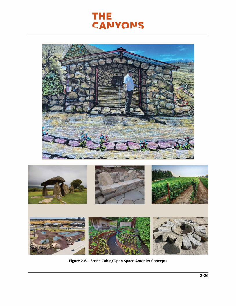
2-26
Figure 2-6 – Stone Cabin/Open Space Amenity Concepts

2-27
Figure 2-7 – Open Space Amenity Concepts

2-28
d) An amphitheater may be developed adjacent to the cabin and is envisioned to allow for community
events such as summer concert series, small performances, nature programs, etc.
e) Seating for the amphitheater shall be incorporated into the natural site terrain. If formal seating is
provided, it shall be constructed of native rock designed to blend with the natural environment. Refer to
Figure 2-8.
f) Amphitheater seating shall have a maximum capacity of 200.
g) Amplified music/voice shall only be permitted between the hours of 12:00 pm and 8:00 pm Sunday
through Thursday and 12:00 pm to 9:30 pm on Friday and Saturday and shall not exceed 65Db at any
residential property line.
h) Lighting of the cabin area and amphitheater shall be limited to bollard style lighting no more than 4-
feet in height.
i) Community amenities such as shared gardens, vineyards, olive orchards, etc. shall be permitted within
open space areas with approval by the DRC. Amenities that result in grading of over 200 square feet shall
be subject to the review and approval of a Site Plan Review by the City of Reno in order to ensure
compliance with the standards contained herein.
Urban/Wildland Interface/Wild Horse Corridor The Canyons is located within an urban/wildland interface area subject to wildfires. As such, the following standards shall apply: a) New development that abuts open space and/or natural areas shall provide a minimum of 30-feet of defensible open space adjacent to homes with a 100-foot buffer zone to include minimal plantings, consistent with standards adopted by the Reno Fire Department (RFD). Refer to exhibit on right. b) With individual tentative maps and/or project approvals, RFD shall have the ability to condition site specific fire mitigation requirements such as increased defensible space, specific plant palettes, etc.

2-29
c) The Canyons HOA shall be responsible for the maintenance of common areas outside of individual lots to ensure weeds and other combustibles are removed in order to maintain a minimum of 20-feet of defensible space from the property line of an abutting unit.
d) With new development, access to open space areas shall be coordinated with the RFD to allow for fire equipment to access open space/common areas during a wildfire event. e) A vehicular access for emergency vehicles shall be maintained year round on the private secondary access road maintained by the HOA. f) The Master Developer is actively working with local and state agencies, as well as horse advocate groups to provide a corridor that allows wild horses to migrate through the area and prevents migration into developed areas. This is a joint effort between The Canyons and adjoining properties. Fencing will promote the safety of residents as well as the feral horses. In accordance with NRS 569.431, the Master Developer (or their assignee) will erect a preconstruction fence to prevent feral horses from entering construction areas.
Grading Grading within The Canyons shall respect the natural topography of the site and be designed to reduce the amount of overall site disturbance. In addition to Reno Municipal Code requirements, the following standards shall apply:
a) Design of residential neighborhoods shall be sensitive to the natural terrain. Structures shall be located in such a manner so as to minimize necessary grading and preserve natural site features including drainageways, slopes in excess of 30%, rock outcroppings, etc.
b) Grading of subdivisions or pad sites shall be designed to blend the edges of development with the adjoining natural terrain. This may be accomplished through the use of rockery walls or stepped foundations in order to reduce the length of man-made slopes, etc.

2-30
c) Landscaping and native revegetation shall be the preferred method of slope stabilization as opposed to rip rap on all manmade slopes. If rap rap occurs, it shall be covered with soil and revegetated with a native seed mix. d) Graded slopes shall be rounded resulting in smooth, harmonious transitions between the man-made terrain and the natural terrain. e) Graded slopes shall be revegetated prior to the issuance of a certificate of occupancy for new homes. This standard may be phased with the phased development of individual projects (i.e. slopes shall be revegetated concurrently with development within any given phase). If climatic conditions or other circumstances prevent planting at the time of occupancy, a bond shall be provided for landscaping during the subsequent growing season to the satisfaction of the Administrator.
f) Drought tolerant plant species and native reseeding shall be utilized to help minimize erosion. g) Slopes contained within individual lots as a result of terracing shall be maintained by the property on the down slope side. h) All grading shall comply with the requirements and disturbance limitations as set forth in the Reno Municipal Code, section 18.12.1601 (Hillside Development)
Mailboxes Individual mailboxes, if allowed by the United States Postal Service (USPS), shall be paired at driveways to serve adjacent homes. The style of the mailboxes, including address numbers shall be compatible with the architectural styles of the homes and shall be consistent throughout each project within The Canyons. Mailbox designs shall be approved by The Canyons DRC and the USPS. Mailboxes shall be provided and installed by individual builders prior to the issuance of certificates of occupancy for the individual homes. When individual mailboxes are not permitted, clustered boxes shall be located in convenient areas conducive to temporary on-street parking. Placement of cluster boxes shall not be near intersections and shall not conflict with individual driveways or utilities. Locations shall be approved by the USPS and the DRC. The United States Postal Service (USPS) shall be responsible for the maintenance of mailboxes/mailbox cluster boxes within The Canyons.

3-1
3 SITE DESIGN AND ARCHITECTURAL STANDARDS
Overview The purpose of this chapter is to establish base standards and design parameters for which future development within The Canyons shall follow. These standards will guide the development of the PUD area by providing specific design criteria for grading, building orientation, landscaping, lighting, signs, walls and fences, and other design elements that tie the community together. Implementation of these standards will help to create the sense of place discussed in Chapter 1. The Canyons aims to set itself apart from other communities within the marketplace through the establishment of its Desert Modernism theme. Inspiration for the architectural standards comes from the vibrant modern architectural heritage of the desert West. Architecture within The Canyons is intended to provide sleek modern homes that embrace the natural environment of the site. The dramatic backdrop of the site along with expansive views of the Truckee Meadows inspire a design aesthetic of mid 20th Century Desert Modernism, as detailed within this chapter. Architectural standards and guidelines are provided to ensure projects within The Canyons are attractive, relate to one another, and reinforce the project theme. The pictures contained in this chapter are provided to convey “imagery” of the standards and guidelines but are not intended to restrict creativity or site adaptability. Instead, the Design Guidelines create a theme for buildings and landscaping within The Canyons in order to protect, maintain, and enhance property values while reinforcing the community’s sense of place. The concepts and implementation techniques set forth herein are not meant to discourage unique design solutions, rather they embody the intent of the design for The Canyons. As new projects (i.e. tentative maps) move ahead within The Canyons, they shall be reviewed in context with the standards included within this chapter. This includes review by the The Canyons Design Review Committee (DRC) and City of Reno to determine consistency with site design and architectural standards.

3-2
Site Planning Guidelines The purpose of the site planning standards and guidelines is to address general provisions of site development which include building orientation, landscape, lighting, signs, and walls and fences. Site planning controls the proper placement of buildings and internal roads that service and access the various areas of the community. It addresses the linkages and land use relationships at a human-scale, in order to create a stimulating and visually pleasant community. The goal is to promote pedestrian activity and safety, create visual compatibility with surrounding neighborhoods, and minimize negative impacts on the natural environment. Site planning, architectural design, and landscape design shall be consistent throughout The Canyons in order to promote neighborhoods that fully integrate with one another. There are a variety of methods to accomplish this including the use of consistent fencing, landscape treatments, design elements such as neighborhood entries, etc. Furthermore, this will be reinforced with the Desert Modernism design theme that is further described herein. Individual neighborhoods within The Canyons shall promote visual diversity and avoid monotonous development patterns. Methods to achieve this include, but are not limited to: not repeating floor plans/elevations directly next to each other, providing for a minimum of two distinct elevations for each home plan (for non-custom villages), designing homes so that the garages are integrated into front elevations, varying setbacks within the neighborhood, including design elements such outdoor living spaces, 8-foot entry doors, decks, covered patios, etc. Additionally, hillside adaptive architecture (i.e. walk-out basements and split-level floorplans) will be required for certain areas within The Canyons in order to reduce the amount of necessary site grading. Standards: The following standards and guidelines promote visual diversity within individual neighborhoods:
a) To the extent practical, mirroring of facades shall occur between lots so that garages and entries are adjacent to each other. This creates variations in setback, providing for a more visually diverse streetscape. The pattern shall include breaks so that it creates variation with patterns across the street and does not become overly repetitious. This standard shall not apply to zero lot line products.
b) Front elevations that face the street shall integrate
garages to the extent possible. Methods to achieve this include off-setting the garage matching the garage architecturally with the primary façade, or incorporating alternatives such as side load or split garages (see example to left)

3-3
c) Neighborhoods that border the community trail system shall provide for a point of connection with
final neighborhood design. Connection points can occur at the end of cul-de-sacs or within dedicated public access easements located within common open space. Trail connection points shall provide a minimum width of 8 feet and transition to the natural trail design described previously in Chapter 2.
d) Single family lots that abut common areas and
open space shall utilize open rear yard fencing. This is intended to provide a sense of openness within common areas and avoids a “walled off” appearance.
e) In order to reduce the amount of grading required, the use of stepped building pads shall be required for lots in areas where significant visual scarring would otherwise occur (see examples below).

3-4
Grading Individual projects within The Canyons shall be include a site-sensitive grading approach that minimizes cut/full slopes and includes techniques to reduce visual scarring including hillside adaptive building pads, use of rockery walls, and native revegetation. Standards not specifically addressed herein shall be subject to the provisions of the Reno Municipal Code. Standards:
a) Design of residential neighborhoods shall be sensitive to the natural terrain. Structures shall be located in such a manner so as to minimize necessary grading and preserve natural site features including drainageways, slopes in excess of 30%, rock outcroppings, prominent knolls, etc.
b) Grading of subdivisions or pad sites shall be designed to blend the edges of development with the adjoining natural terrain. This may be accomplished through the use of rockery walls in order to reduce the length of man-made slopes, etc.
c) Landscaping and native revegetation shall be the preferred method of slope stabilization as opposed to rip rap on all manmade slopes.
d) Graded slopes shall be rounded resulting in smooth,
harmonious transitions between the man-made terrain and the natural terrain.
e) Graded slopes shall be revegetated prior to the issuance of a certificate of occupancy for new
homes. This standard may be phased with the phased development of individual projects (i.e. slopes shall be revegetated concurrently with development within any given phase). If climatic conditions or other circumstances prevent planting at the time of occupancy, a bond shall be provided for landscaping during the subsequent growing season to the satisfaction of the Administrator.
f) Drought tolerant plant species and native reseeding shall be utilized to help minimize erosion (refer to approved seed mix).
g) Slopes contained within individual lots as a result of terracing shall be maintained by the property
on the down slope side.
h) Rockery walls within common area or open space shall be inspected annually and maintained by the HOA.

3-5
Landscaping The intent of The Canyons landscape standards is not to create stark contrasts between new development and the natural environment. Rather, landscaping standards encourage the use of native and drought tolerant plantings in order to embrace the site features and blend the community with the natural environment. Standards:
a) Individual builders shall be responsible for landscaping the front yards of new homes within The Canyons. Front yard landscaping shall be completed with the issuance of a certificate of occupancy and pre-approved by the DRC. In instances of inclement weather, front yard landscaping may be completed within 3 months of final certificate of occupancy with DRC approval.
b) Front yard landscaping shall include an automatic irrigation system.
c) At a minimum, each individual front yard shall include one tree per 400 square feet of yard area.
d) Neighborhoods with common yards (i.e. community greens) shall provide trees at intervals not to
exceed 30 feet.
e) Rear yard landscaping shall be provided by individual homeowners. Rear yard landscape improvements shall be reviewed and approved by the DRC and installed within 90-days of the escrow closing date. If rear yard landscaping is not completed within 90-days financial penalties may be applied by the HOA based on CC&R requirements/policies. The HOA and/or DRC may extend this timeline based on seasonal delays, inclement weather, etc. at their discretion.
f) Landscape character may vary from neighborhood to neighborhood while reinforcing the overall
project theme. Each neighborhood may use a unique plant palette with the approval of the Design Review Committee. Project entries shall retain a common theme, as previously described in Chapter 2.
g) As an alternative to turf, natural xeriscaping and low-water plant materials are encouraged for front yards and common yards with the approval of the DRC. Refer to examples on following page.

3-6

3-7
i) Common area landscaping shall incorporate the
use of natural onsite features. This may include boulders or the relocation native plant materials. An example is the use of stumps and previously burned trees relocated and used as landscape features that appear to native to the landscape. See example to right.
j) Common area landscape features should draw from the natural materials found onsite such as native stone and rock. These materials can be used to create benches, stairs, etc. that fully blend with the natural landscape.
k) The use of rock “cages” is encouraged in the use of landscape accents and features and shall incorporate the use of native stone found onsite.

3-8
l) Outside of formal entries and gateways, the
use of native plant materials such as pinion pines and desert shrubs shall become the predominant landscape material. Refer to approved plant palette included in the appendices of this handbook.
Project Entry A grand entry will greet residents and guests as they enter The Canyons. The entry will provide a clear community distinction and reinforces the Desert Modernism theme with the use of natural onsite materials and modern design.

3-9
Lighting The primary purpose of lighting within The Canyons is to provide for the safety and security of residents and guests. Additionally, lighting can be used to accent community features such as the stone cabin, project entry, and formal landscape treatments. Standards:
a) Single family residences shall incorporate exterior lighting that is compatible with the architectural design of the home and includes fixtures that eliminate spill-over of light to adjoining parcels.
b) Exterior landscape lighting may be used to accentuate architectural features, landscape elements, etc. and shall be subject to review and approval of the Design Review Committee.
c) Projects with community greens or common yards may choose to
include bollard lighting. Bollards may also be used to define trailheads and light pathways leading to and from the stone cabin. Bollard lighting shall not exceed 4-feet in height.
d) As detailed in Chapter 2, streetlights may include fixtures that vary from NV Energy standards. Should fixtures be incorporated that are not acceptable by NV Energy, the HOA or designated sub-association shall be responsible for all streetlight maintenance, including poles and fixtures.
e) All street lighting within The Canyons shall be compliant with the standards included in Chapter 2.

3-10
Walls and Fencing The use of solid fencing within The Canyons is highly discouraged. Rather than having walled-off yards that obstruct views, openness, and the natural site beauty, the use of landscaping and open fencing will be incorporated. Standards:
a) Fencing of individual lots within The Canyons is not required and shall be at the individual builder’s discretion, with approval by the Design Review Committee.
b) The use of landscape features, landscape walls, shrubs, and trees are an acceptable method of
delineating property boundaries and yards. All landscape improvements shall be reviewed and approved by the DRC.
c) Side yard fencing shall be limited to the use of rock, rock cages, or native material (to the approval of the DRC) and shall not exceed 30-inches in height.
d) Rear and side yards adjoining roadways and/or open space may utilize open fencing. Open fencing may include iron mesh, clear plexiglass, or similar. A solid 30-inch base with open fencing above may be permitted with DRC approval. Base material may include rock cage or Gabion fencing or masonry (stucco or decorative CMU).

3-11
e) Decorative fencing that serves an architectural element
of the primary residence or carries forth an architectural theme may be permitted with approval of the DRC. Refer to example at left.
f) Solid fencing and that which obscures or obstructs views within the community shall be prohibited.
g) No fencing shall occur within front yard setbacks.
h) Single family lots and projects with common yards or community greens may include privacy walls,
such as courtyard or patio walls, and shall not exceed 4 feet in height. These walls shall incorporate materials and colors consistent with the architecture of the homes.
i) A 6-foot solid screen wall or fence may be used adjacent to public utility structures, subject to DRC
approval and shall be screened with landscaping to soften their appearance.
j) All walls and fences associated with a project shall be installed concurrently with the project. Fences within residential lots shall be maintained by the lot owner.
k) Chain link fencing shall only be permitted with temporary construction yards and is prohibited within individual lot and common areas.
l) Fencing for non-residential uses including amphitheaters, stone cabin, and/or community gathering
spaces shall conform to the standards contained within the Reno Municipal Code.
m) Wildlife fencing may occur along the eastern and northern property boundaries in order to discourage wild horses from migrating into The Canyons and adjoining neighborhoods. Fencing shall be located to direct horses towards established migration routes and shall include the use of open wire (or comparable fencing). All wildlife fencing shall be reviewed and approved by the DRC, City of Reno, and Nevada Department of Wildlife.
n) Courtyard walls, open view glass fencing, and decorative open metal fencing screened with landscaping may be used up to 4-feet in height around swimming pools in order to meet City of Reno Municipal Code safety standards.
o) All fencing shall be approved by the DRC and consistent throughout the village in which it is located.

3-12
Architectural Standards and Guidelines The Canyons architectural standards are to be used as a general guideline and framework that reinforces the Desert Modernism/Desert Contemporary theme. Variations to these guidelines shall be permitted when the proposed deviation expands upon the project theme or is needed to address unique architectural elements, site conditions, etc. The guidelines are not intended to be restrictive, but rather promote both visual compatibility and variety within the PUD area by utilizing complementary Desert Contemporary styles. The intended result is a high level of design direction and quality. Any variation to the standards is subject to review and approval by the DRC. Architectural Theme As discussed in Chapter 1 and this chapter, The Canyons draws from the natural and indigenous materials found onsite. Rather than developing a community that contrasts with the dramatic backdrop of the property, the intent of The Canyons architectural standards is to provide for architecture that blends into the natural landscape. The Desert Modernism theme incorporated contemporary architecture and encourages the use of natural materials such as rock and stone, heavy timbers, etc. as architectural design elements reminiscent of the project vision. Additionally, contemporary home designs that include non-traditional roof lines, large neutral wall planes, etc. will allow homes to blend with the natural features of the site. Steeper homesites will include the use of stepped foundations that are hillside adaptive in order to greatly reduce grading and visual scarring. Modern and contemporary architecture will clearly help define neighborhoods within The Canyons from those to the west and serves to reinforce the project theme. In order to allow for variety, deviations to the architectural theme, including more eclectic designs, shall be permitted and can complement differing styles through the inclusion of common design elements. The ultimate goal of these standards is to create a high quality, attractive community that provides diverse housing choices to suit the variable tastes and needs of future residents. The application of these architectural guidelines and standards to individual development projects will be reviewed and approved by the DRC and the City of Reno Community Development Department. New interpretations of these standards including combinations of materials are encouraged as they relate to a general feeling of neighborhood unity. The following sections provide guidelines and standards that will aid in the creation of a community which residents can be proud to call home.

3-13
Single Family Architectural Standards A key element of The Canyons architectural guidelines is to create a streetscape possessing both function and visual variety. The guidelines are intended to provide variety in appearance as well as a sense of individuality for each structure. Projects where identical buildings line the streets without variation in form and mass are prohibited. It is recognized that all architectural styles are open to interpretation in design. Therefore, these standards are not intended to limit creativity or prevent certain types of design. Instead, they should be viewed as a baseline for review in terms of quality, general theme, etc. Deviations may be permitted with the review and approval of The Canyons DRC and the Administrator.
Design Characteristics The architectural styles of The Canyons are rooted in the Desert Modernism style reflective of contemporary designs. This style will set The Canyons apart from surrounding communities and create a strong sense of community for residents. The styles are reflective of building forma and details reminiscent of traditional post-modern design made famous in areas such as Palm Springs. The use of natural materials reflects the history of the West and site area while expressing the overall vision of the community. Standards:
a) A minimum of 3 of the following design elements shall be incorporated into all residential elevations included within The Canyons:
• Flat roofs
• Cantilevered Flat roofs
• Simple rooflines
• Deeply recessed window and door openings
• Deep canopies
• Varied plate heights and/or parapet walls
• Stucco walls
• Post and beam construction at primary living spaces
• Simple, uncluttered, uncomplicated exterior design
• Design that maximizes light exposure
• Long, low horizontal proportion
• Use of sliding glass doors
• Minimal decorative detailing
• Accent walls that incorporate native rock or similar material

3-14
Elevation Variations Residential elevations shall provide visual interest, reinforce the community theme, and avoid a monotonous appearance. Standards: a) Facades of buildings styles shall make use of expressive structural elements such as brackets and columns, variable window types, a mixture of natural materials such as rock. b) A minimum of two (2) distinctive floor plans shall be used within each individual non-custom village within The Canyons. Non-custom villages shall be those that contain 15 or more units. c) The architectural detailing similar to that of the front elevations shall be utilized on all sides of the home. d) Any building addition or additional building(s) (over 200 square feet) on a property shall match the main structure in building design, materials, roof pitch and architectural character. e) The exterior mass and form of residential architecture should be varied within neighborhoods to improve the streetscape. This can be accomplished through (but is not limited to) varied setbacks, floorplans, facade detailing, massing and rooflines.

3-15
Windows The style, placement, orientation, and design of windows plays a significant role in the overall architectural theme and can greatly enhance home values based on viewscapes they create. The following standards shall apply within The Canyons. Standards:
a) Window placement shall take advantage of mountain, valley, and/or open space/common area views.
b) Windows shall be placed as
to not be overly obtrusive to the privacy of adjoining residences. The DRC shall be responsible for determining compatibility with this standard.
c) All windows shall be double-glazed to maximize energy conservation. Glass may be tinted but shall not be reflective or mirrored.
d) As a method of reinforcing a connection with the outdoors, large windows and sliding glass doors opening from the primary living areas are encouraged.
e) Windows shall incorporate aluminum or vinyl frames.
f) Window trim shall be minimal and reflective the Desert Modernism/Contemporary design theme.
g) Round windows and frames are prohibited.

3-16
Doors and Entries The front door of homes within The Canyons shall create a sense of grandeur while complementing the overall architecture of the home. Standards:
a) Primary entry doors shall be
a minimum of 8-feet in height.
b) Entry doors shall be
constructed of either solid wood, fiberglass, aluminum, or composite material with a stained or painted finish.
c) The use of double entry
doors shall be subject to the review and approval of the DRC and shall demonstrate compliance with the Desert Modernism/Contemporary theme.
d) Dutch or cottage style doors
are prohibited.
e) The incorporation of windows and side lights is highly encouraged within front entries.
f) The use of vivid colors that provide contrast as an architectural element are encouraged. The use of
bland colors such as white and beige is highly discouraged unless it can be demonstrated that it is a key element of the overall architectural design of the residence, subject to DRC approval.

3-17
Garages Garages shall be architecturally integrated into new homes within The Canyons and shall not be the predominant feature of front elevations. Standards:
a) Variety in garage placement is encouraged to avoid monotonous streetscapes. A garage should not be the dominant feature in the architecture of the home.
b) The impact of repetitive street front garages
can be reduced by:
• Varying garage door appearance and placement from plan to plan.
• Varying garage front yard setbacks from the garage and/or living space.
c) A minimum 8-inch recess shall be provided at
all garage doors.
d) Garage trim shall be simple and not include windows, decorative hardware, etc.
e) The use of dark colors is encouraged for garage doors. White garage doors shall be prohibited.

3-18
Outdoor Living Spaces
The incorporation of outdoor living spaces provides a sense of openness within the home, enhances resident quality of life, and expands overall useable living area of the home. Integration of indoor and outdoor living spaces for leisurely enjoyment is highly encouraged within The Canyons.
Standards:
a) The use of multiple outdoor living spaces such as courtyards, covered patios, etc. is highly
encouraged for all homes. b) For homes located with Canyon Creek and Canyon Meadow, individual builders may choose
to include side yard reciprocal use easements. This shall allow for consolation of the two side yards into a larger space that extends to the adjoining home. This enlarged use area shall be for the purpose of encouraging and extending outdoor living elements, subject to DRC approval.
c) The placement of second floor
decks shall be reviewed and approved by the DRC prior to construction in order to evaluate privacy impacts upon adjoining homes.
d) Covered patios shall be subject to
the setback regulations outlined in Chapter 2. This standard shall not apply to side yards that include a reciprocal use easement.
e) Rear yard covered patios shall
include a 2-foot minimum offset from the primary structure.

3-19
Exterior Paint and Materials
Allowed materials and paint colors are indicative of the Desert Modernism/Contemporary theme and serve to reinforce the overall project theme.
Standards:
a) Low, pony, and courtyard walls attached to the primary structure shall match or enhance colors on the elevations.
b) Fascia and eaves may include contrasting accent colors and shall be reviewed and approved
by the DRC. c) Undersides of eaves and overhangs shall incorporate the same color as the primary
residence. d) Approved exterior materials include stucco and cement fiber siding. e) Natural stone may be used as an accent material with the approval of the DRCZ. f) Home colors shall comply with The Canyons approved color palette, as included below.

3-20
Finish Materials
Finish materials shall complement the primary architectural character of the home and add a sense of uniqueness to residences within The Canyons.
Standards:
a) The use of steel posts at covered patios is highly encouraged. b) Low walls that are attached to
the primary structure (i.e. courtyard walls, garden walls, etc.) shall match the finish of the primary dwelling.
c) Flagstone, lava rock, cobble
stone, and glass tiles are not permitted on exterior walls.
d) Exterior lighting is encouraged
to be located under eaves and adjacent to points of entry. Refer to Lighting section for additional standards.
e) Accent walls may include
precision cut stones and fiber cement paneling.

3-21
Roofs and Mechanical Equipment
The incorporation of flat roofs is encouraged given the architectural theme of the project. Therefore, the following standards ensure that rooftop equipment, as applicable, is properly screened,
Standards:
a) Roofs shall be constructed to weather the harsh desert environment including sun and
applicable snow loads. The roof must be non-flammable and non-reflective. b) Roof overhands shall be permitted to encroach 1-foot into the required setback around the
envelope of the primary structure. c) All mechanical equipment, including any rooftop air conditioning units, satellite dishes,
solar panels, etc. shall be screened from view by architectural elements to the satisfaction of the DRC.
d) Rooftop screening shall occur from all vantage points, not solely the front elevation.
Parapets shall extend a minimum of 6-inches above any rooftop equipment. e) Ground-mounted air conditioning units should provide a minimum of 3-feet of clearance to
allow for access and heat dispersion. f) To the extent possible, ground mounted air conditioning units and utility meters shall be
located as to not be visually obtrusive. g) Utility meters shall be located adjacent to garages, to the extent possible.
Sustainability As noted in Chapter 1, The Canyons is a community that embraces the natural elegance of the site, encouraging minimal disturbance and preservation of significant landforms and features. For this same reason, sustainability will be a key consideration of project architecture. a) The use of energy efficient building materials is required for all new homes. b) The inclusion of solar energy opportunities within new homes is highly encouraged,
including provisions for panels to be located in a visually unobtrusive manner. c) At a minimum, roof shall include a high solar reflection index to reduce the need for
heating and cooling. d) Water conserving plumbing fixtures are required for all new construction.

3-22
Accessory Structures and Uses Detached accessory dwelling units (ADU) and structures such as garden sheds may be permitted, subject to the standards outlined in Chapter 2. Where ADU’s are provided, the following standards shall apply. Standards:
a) Detached ADU’s and casitas shall incorporate the same materials and architectural design as the primary residence that they serve.
b) Detached structures, including garden sheds shall be painted to match the primary structure and
are subject to the setback standards for that village.
c) Play equipment such as jungle-gyms, swing sets, and climbing structures shall be prohibited.
d) Sheds that are visible from the street shall be prohibited. Sheds shall be screened from view of adjoining residences and approved by the DRC.
e) Multi-generational single-family housing that includes an ADU shall be permitted per the standards
included in Chapter 2.
Non-Residential Standards Non-residential uses within The Canyons are limited and intended to promote a walkable neighborhood with community amenities, including limited support commercial and personal service use, as set forth in Chapter 2, Table 2-6. In general, the site planning and architectural standards provided in the Reno Municipal Code shall pertain to all non-residential uses within the PUD boundary. However, the following supplemental standards shall also apply. Standards:
a) A stone cabin structure and adjoining amphitheater shall be permitted within the common area and shall not be subject to the architectural standards contained herein or within Reno Municipal Code. Instead, the cabin may take on a rustic or aged appearance and incorporate natural stone and/or timbers. Final cabin design shall be subject to DRC approval.
b) All non-residential building elevations must be reviewed and approved by The Canyons DRC.
c) Art and/or structures (i.e. sculptures, etc.) may be located in the open space and not subject to
design guidelines, but subject to the approval of the DRC.

4-1
4 CONSTRUCTION, OPERATION, AND MAINTENANCE
4.1 Clean Job Site As construction occurs within The Canyons, individual developers/builders shall ensure that construction
sites, including standing and storage areas, are maintained in a clean and orderly fashion. Any hazardous
materials (i.e. gasoline, paints, etc.) shall be stored in proper OSHA approved containers and in accordance
with all applicable local, State, and Federal standards/permits.
4.2 Protection of Vegetation During Construction
Natural vegetation outside of the limits of grading for any given project within The Canyons PUD area shall
be protected from damage during construction. Any common or open space areas that are disturbed
during construction (i.e. extension of utilities, construction access, etc.) shall be fully restored. Disturbed
open space areas shall be revegetated with native vegetation. All developed/improved common areas shall
be returned to their natural state, although additional landscaping, irrigation, and other refinements may
be provided.
4.3 Temporary Protective Fencing
Construction that is adjacent to any open space areas, areas of public activity (i.e. trails) or significant
natural features shall be required to erect temporary protective fencing to ensure that these areas are not
disturbed, and that public safety is preserved.
4.4 Erosion Control Plan and Storm Water Pollution Prevention Plan (SWPPP)
Per Reno Municipal Code and Nevada Division of Environmental Protection (NDEP) policies and
regulations, all construction projects are required to have an Erosion Control Plan and Storm Water
Pollution Prevention Plan (SWPPP) in place prior to commencement of any grading activities. Erosion
Control Plans shall be reviewed and approved by the Administrator and the Washoe County District Health
Department. The SWPPP shall be approved by the NDEP. This standard applies for any and all land-
disturbing activities that occur within the PUD area.

4-2
4.5 Temporary Structures and Signs
Temporary structures such as construction trailers, portable offices, temporary sales offices, etc. shall be reviewed by the Master Developer and/or the DRC as to their location, hours of operation, etc. To the extent possible, construction trailers shall be located away from public rights-of-way, trails, and active common areas. All temporary structures shall be removed within 30 days of the completion of work or issuance of final certificate of occupancy (as applicable). Individual projects within The Canyons shall be permitted two 32 square foot temporary project identification signs. The purpose of these signs is to identify the project and may include builder name, selling price, contact information, phasing announcements, financing source, etc. This sign may not replace the required project entry monument (refer to Chapter 2) and shall be removed concurrently with the sale of the final home within that particular neighborhood. All temporary signs shall be reviewed and approved by the Master Developer or The Canyons DRC. Security fencing associated with temporary structures and construction is permitted. This includes the use of chain link and barbed wire fencing on a temporary basis. Fencing shall be limited to no more than 6 feet in height and shall be removed concurrently with the temporary structure or completion of construction.
4.6 Model Home Complexes
Model Home Complexes shall comply with the following standards:
a) The location of model home complexes and details regarding parking, lighting, landscaping, fencing, signing and hours of operation shall be reviewed and approved by Master Developer and the Administrator.
b) Model home complexes/sales offices shall be limited to operations between the hours of 8:00 am to 6:00 pm, 7 days per week.
c) Any temporary sales office and/or model home complex shall cease operation with the sale of the
final home in the subdivision. All temporary signs and other temporary fixtures shall be removed concurrently.
d) Accessible parking shall be provided per Reno Municipal Code standards for all model home complexes.
e) Temporary parking lots, subject to ADA standards shall be permitted with new model home complexes and shall be removed concurrently with the sale of the final unit within the subdivision.

4-3
f) Temporary open view fencing is permitted within the front yard setbacks of model home complexes and shall be removed with the sale of the final unit within the subdivision. Acceptable fencing includes wrought iron or split rail and shall not exceed 4 feet in height.
g) Lighting for model home complexes may be provided for safety and security purposes and shall be
approved by the Master Developer and/or the DRC. Temporary security lighting shall be removed with the sale of the final unit within the subdivision.
h) Lighting of temporary parking lots, other than bollard lighting limited to 4 feet in height, shall be
prohibited.
i) Temporary flags and flag poles shall be permitted within model home complexes subject to review
and approval of the Master Developer and/or DRC. All flags and flag poles shall be removed with
the sale of the final unit within the subdivision.
4.7 Construction Yards and Hours
As construction commences within The Canyons, construction yards will be necessary. A construction yard is a temporary area used for the storage of materials, supplies, tools, equipment, etc. The following requirements will apply to all projects within The Canyons PUD area:
a) Construction hours, including activity within construction yards, shall be limited to 7:00 am to 8:00 pm weekdays and 9:00 am to 6:00 pm on weekends.
b) To the greatest extent practical, new construction yards shall be located away from existing
residences.
c) Construction yard location shall be reviewed and approved by the Master Developer and/or the DRC.
d) Construction yards shall be subject to any applicable City of Reno permits . If applicable, a Washoe County District Health Department dust control permit shall be required.
e) Construction yards shall be removed, and sites returned to a natural or developed state with issuance of the final certificate of occupancy within the subdivision(s) they serve.
f) All construction yards shall be kept in a neat and orderly fashion. All materials, equipment, etc. shall be kept behind a 6-foot minimum fence. Acceptable fencing includes wood or chain link and may include barbed wire.
g) Temporary pole lighting is permitted within construction yards for security purposes. All fixtures shall be shielded to ensure spill-over and glare does not occur on adjoining properties.

4-4
h) An onsite resident may be permitted within temporary living quarters (modular unit or recreational
vehicle) within active construction yards for security purposes.
i) The project contractor shall be responsible for obtaining applicable permits and enforcement of these standards.
4.8 General Construction Standards
a) Construction hours shall be limited to 7:00 am to 8:00 pm weekdays and 9:00 am to 6:00 pm on weekends.
b) Individual builders shall be responsible for obtaining all required permits such as dust control,
SWPPP, etc.
c) Roadways within construction areas shall be kept free of debris such as scrap materials, nails, etc. and shall be swept on a regular basis.
d) Adequate dumpsters shall be provided within construction areas to ensure debris does not spill over into streets or blow off-site.
e) Builders shall designate to the Master Developer and City of Reno a project contact person responsible/authorized to correct problems regarding the project on a 24-hour/7 days a week basis.
f) Fencing may be erected around construction sites on a temporary basis. This may include chain link at a maximum of 6-feet.
g) The Master Developer, HOA, or any designated sub-association, shall ensure the implementation of Best Management Practices to prevent the spread of noxious weeds during construction activities.
4.9 Common Area Maintenance The Canyons will include a significant amount of common area and open space. This includes both private and public common areas. In general, private common areas will be located within individual subdivisions and may include neighborhood greens, private recreational amenities, private streets, etc. Public common areas include dedicated open space, trails, drainageways, utility corridors, etc.

4-5
4.9.1 General Maintenance Standards
a) Concurrent with the approval of the first tentative map or development permit (i.e. road construction), the Master Developer shall submit a final Three-Year Maintenance Plan to the Administrator for review and approval. The maintenance plans shall be reviewed and updated, as necessary, by the Administrator every 3 years.
b) Prior to or concurrent with the issuance of the first building permit, the Master Developer shall
demonstrate that the master homeowner’s association, The Canyons HOA, has been formed and articles of incorporation are filed with the Nevada Secretary of State.
c) The Canyons HOA shall be responsible for the ongoing maintenance of all public common areas within the PUD Area. This includes vegetation, preservation of watersheds, debris and litter removal, trail maintenance, maintenance of community signs and amenities, landscape maintenance, maintaining public access where applicable, noxious weed abatement, etc.
d) The Canyons HOA shall be responsible for the permanent maintenance of public common/open spaces.
e) As an alternative to a Homeowner’s Association, an alternative legal instrument may be formed to provide for the ongoing permanent maintenance of common/open space areas and community amenities. Acceptable instruments include a Landscape Maintenance Association (LMA) or Landscape Maintenance District (LMD) subject to the approval of the Master Developer and City of Reno.
f) The Canyons HOA or any subsequent entity charged with the task of maintenance shall comply with the regulations set forth in NRS 278A.120 through 278A.190.
g) The City of Reno shall not be responsible for common or open space areas within The Canyons.
h) The Master Developer, HOA, or any designated sub-association shall include the implementation of Best Management Practices to prevent the spread of noxious weeds during construction activities.
4.9.2 Private Open Space and Common Areas
a) Private Open Space and common areas such as neighborhood greens, private streets, etc. shall be maintained by the HOA or a designated sub-homeowner’s association specific to an individual neighborhood.
b) Sub-homeowner’s associations must comply with all applicable rules and regulations, including any
adopted covenants, conditions, and restrictions (CC&R’s), included within the PUD and shall require approval to be formed by the Master Developer and Administrator.

4-6
c) The Canyons HOA may choose to maintain private common areas through an agreement with a sub-
HOA or individual builder. This shall be subject to approval of the Master Developer and/or The Canyons Homeowners Association Board of Directors.
d) The Master Developer and subsequent Homeowners Association(s) shall include the implementation of Best Management Practices to prevent the spread of noxious weeds during construction activities.


