The City of Hollis Community Wildfire Protection Plan AN ACTION PLAN FOR WILDFIRE MITIGATION DATE: June 2011 Prepared by: Mark Gardner Organization: South Western Oklahoma Development Authority (SWODA) Contact Information: Address P.O. Box 569 Phone 580/562-4882 E-Mail [email protected]FAX 580/562-4880
Transcript
The
City of Hollis Community Wildfire Protection Plan
AN ACTION PLAN FOR WILDFIRE MITIGATION
DATE: June 2011
Prepared by: Mark Gardner
Organization: South Western Oklahoma Development Authority (SWODA)
Wildfire Protection Plan: An Action Plan For Wildfire Mitigation 2
The following report is a cooperative effort between various entities. The representatives listed below comprise the core decision-making team responsible for this report and mutually agree on the plan’s contents.
Wildfire Protection Plan: An Action Plan For Wildfire Mitigation 3
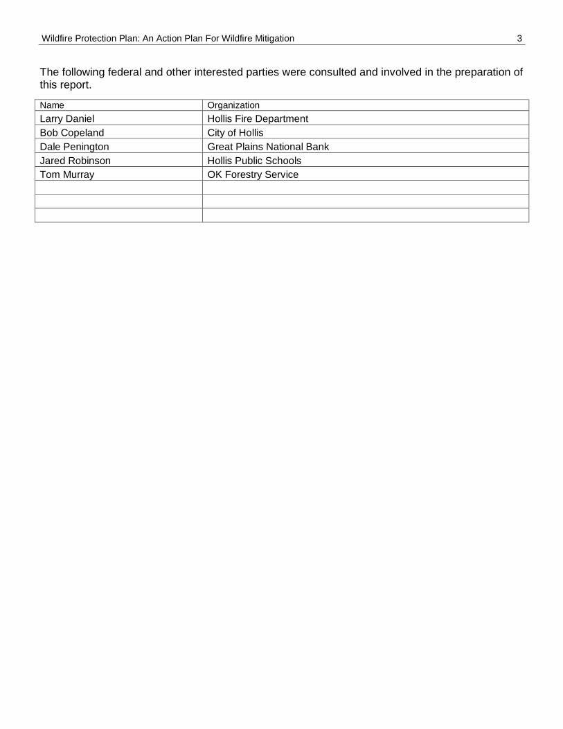
The following federal and other interested parties were consulted and involved in the preparation of this report.
Name Organization
Larry Daniel Hollis Fire Department
Bob Copeland City of Hollis
Dale Penington Great Plains National Bank
Jared Robinson Hollis Public Schools
Tom Murray OK Forestry Service
Wildfire Protection Plan: An Action Plan For Wildfire Mitigation 4
PLAN CONTENTS
1. Community Background and Existing Situation 2. Community Base Map and Other Visuals 3. Objectives and Goals 4. Prioritized Mitigation Recommendations 5. Action Plan 6. Wildfire Pre-Suppression Plan 7. Additional Comments 8. Attachments
Wildfire Protection Plan: An Action Plan For Wildfire Mitigation 5
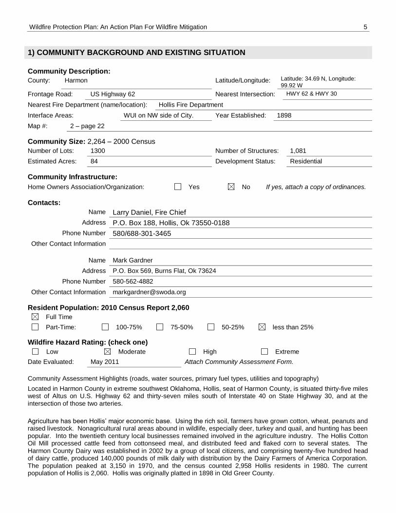
1) COMMUNITY BACKGROUND AND EXISTING SITUATION
Community Description:
County: Harmon Latitude/Longitude: Latitude: 34.69 N, Longitude: 99.92 W
Date Evaluated: May 2011 Attach Community Assessment Form.
Community Assessment Highlights (roads, water sources, primary fuel types, utilities and topography)
Located in Harmon County in extreme southwest Oklahoma, Hollis, seat of Harmon County, is situated thirty-five miles west of Altus on U.S. Highway 62 and thirty-seven miles south of Interstate 40 on State Highway 30, and at the intersection of those two arteries.
Agriculture has been Hollis’ major economic base. Using the rich soil, farmers have grown cotton, wheat, peanuts and raised livestock. Nonagricultural rural areas abound in wildlife, especially deer, turkey and quail, and hunting has been popular. Into the twentieth century local businesses remained involved in the agriculture industry. The Hollis Cotton Oil Mill processed cattle feed from cottonseed meal, and distributed feed and flaked corn to several states. The Harmon County Dairy was established in 2002 by a group of local citizens, and comprising twenty-five hundred head of dairy cattle, produced 140,000 pounds of milk daily with distribution by the Dairy Farmers of America Corporation. The population peaked at 3,150 in 1970, and the census counted 2,958 Hollis residents in 1980. The current population of Hollis is 2,060. Hollis was originally platted in 1898 in Old Greer County.
Wildfire Protection Plan: An Action Plan For Wildfire Mitigation 6
Current Condition
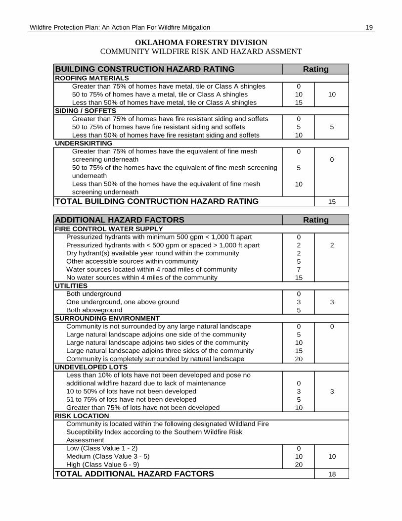
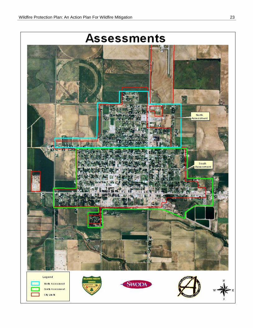
With the small overall size of the City, Hollis has been divided into two sections for simplicity as to the Community Wildfire Risk and Hazard Assessment. Vivian Street has been used as the dividing point, with one assessment to the North of this line, and the other to the South. The assessment scores have been calculated at 82 for the north and 112 for the south. The average overall rating is 97; this puts Hollis into the Moderate Risk category. What does this mean? The chances of a majority of homes in the community surviving a wildfire are Fair. Some minor improvement will make
the community more fire resistant. Although the City is making strives to clean-up abandoned properties, more homeowner education and involvement would be beneficial to the overall Wildfire Risk.
Ingress / Egress
Access: Primary access into Hollis is by ways of HWY 62 running East to West and HWY 30 entering from the North. Both of these access points make entering or leaving the City very easy in case of emergency evacuation..
Signage:
Signage provides clear guidance into the City of Hollis from all directions. All entries are well marked and provide all weather road surfaces adequate to handle any type of emergency vehicle to access all areas of the City. All major intersections of primary and secondary roadways are well marked with “post type” signs.
Subdivision access: All roadways and streets within subdivisions are of hard surface type with sufficient width for access by fire apparatus. It does not appear that there should be any traffic flow problems for residents to leave as fire apparatus are arriving in emergency situations.
Street Signs: Many of the street signs are missing or very faded and difficult to read. Replacing these would be beneficial especially to mutual aid responders in case of emergencies.
Another area of concern is that of house and building numbering. Many of the homes and businesses are not marked with addresses visible from the street. Correcting this would be of great value to emergency responders.
Emergency Evacuation: There should be no evacuation issues for residents leaving in event of emergencies. Streets appear to be of sufficient width for residents to leave as emergency vehicles approach any area of the city. Evacuation routes should be intuitive to all residents as all streets are through streets with a few exceptions, and most of those being private driveways.
Public Fire Protection
Hollis Fire Department: Provides its protection to the residents of the City and surrounding area with a force of 18 volunteer firefighters. This service is provided with a fleet consisting of: 2-pumper trucks, 4-wildland pumpers, 1-3600-gallon water tender, 1-Command vehicle and 1-rescue vehicle.
Water Supply
The City receives its water supply from the municipal water facilities. The City has 5-water wells that pump into 1 clear well with a 208,000 gallon capacity, then into 2- standpipe type tanks. The capacities of the stand pipes are 256,000 gallons and 197,000 gallons. From these the water is gravity feed in to the treatment facility and then to the main lines throughout the city. The City has an ample water supply for fighting any structural or large front wildfire that may threaten the city. The main concern of the water system would be that many of the fire hydrants need to be replaced throughout the community and more added in different areas.
Utilities
The city receives its electrical service from PSO and Harmon Electric Association by the way of overhead transmission lines throughout the community. Natural gas is provided by ONG and Navitas Utilities Corp. through underground piping systems.
Fuel Types
Vegetation and trees throughout the city are typical for the area with a mix of hardwood and evergreen trees. Most areas the vegetation is mowed to a short height. There are some areas within the city limits where mowing and cleaning of trees would be beneficial. These will be identified later in the high hazard area of the plan. Like most communities the practices of allowing trees to grow close to homes have occurred. Homeowner education about
Wildfire Protection Plan: An Action Plan For Wildfire Mitigation 7
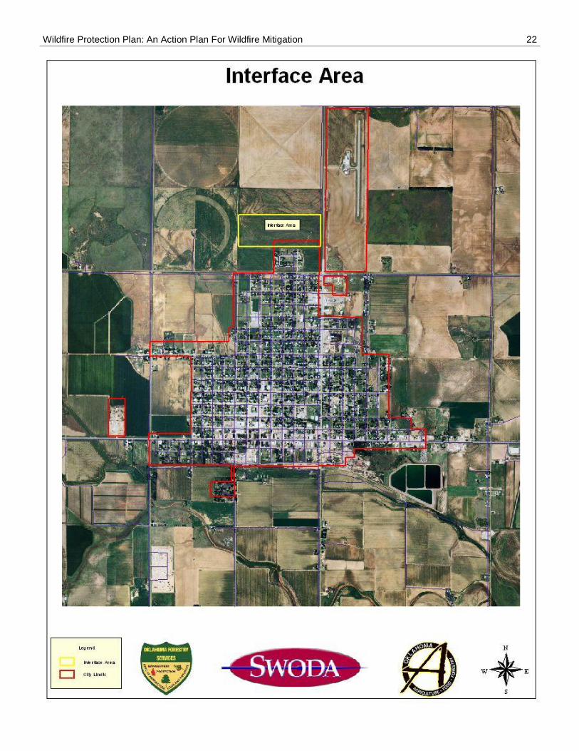
firewise landscaping could benefit the community as a whole. On the north west part of the city appears to be a pasture of tall native grass that is not being grazed. This area could allow fire to migrate into the city threatening homes within the area. Hollis is fortunate to have manmade fire breaks surrounding the remainder of the city by means of its reach heritage of Cotton farms. The likelihood of a large front wildland fire encroaching into city limits is very limited to that of the north west part of town.
Defensible Space
There is a good separation of the homes in the city. There should not be any major problems of protecting surrounding structures should a structural fire occur. The homes vary in construction type from that of brick veneer to ordinary wood and vinyl siding. Roofing material appears to mostly be of regular asphalt shingles with some having metal roofs. There are many abandoned properties in which the City is in process of condemning for removal thus lowering the chance of fire occurrences within the city, The highest fire load within the City limits would be the areas South of Washington Street and on the East side of the City along Walnut Street. Should any fire start in these areas, several blocks could possible burn before being brought under control?
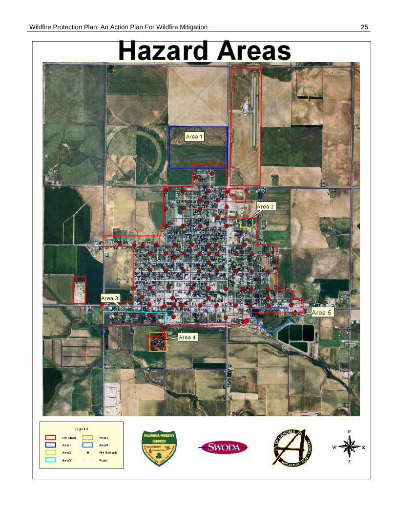
High Hazard Areas
1. Grass field on NW side of City.
2. Excessive trees, tall grass and old structures W of HWY 30 along Walnut St.
3. Excessive trees, tall grass and old structures S of Washington St
4. Trees, tall grass and old structures on S 1st St.
5. Tall grass NW of Sewer Lagoons.
6. Old structures not shown on map scattered throughout the City.
Community Wildfire History: (include surrounding areas)
Relative Frequency: Hollis responds to approximately 85 wildland fires each year.
Common Causes: Carelessness, machinery, escaping debris burning, electrical line arching, lighting storms, discarded smoking materials.
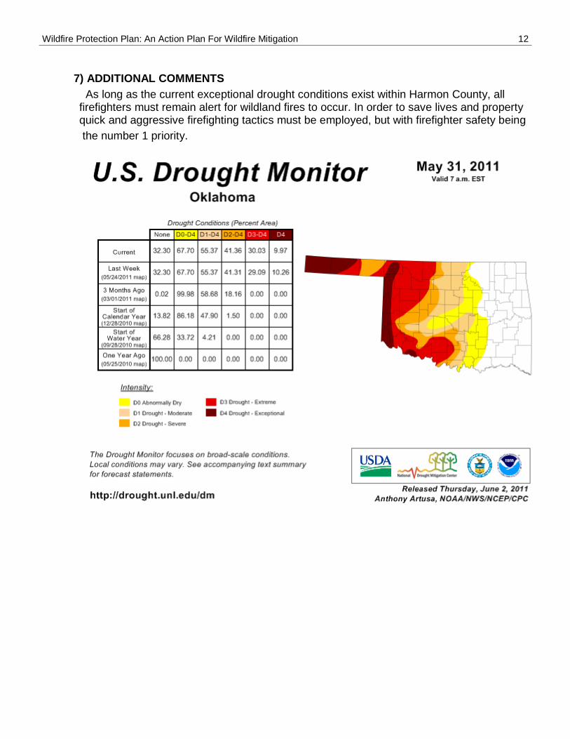
Areas of Future Concern: At present time the area is in an Exceptional Drought situation. There has been very little green up of vegetation. As this continues the chances of large front wildland fires are increasing.
Additional Comments: Purchasing of new and upgrading of equipment will be essential for continued wildland firefighting activities.
2) COMMUNITY BASE MAP AND OTHER VISUALS
See attachment – Base Map.
3) OBJECTIVES / GOALS
Objectives: The objectives of this plan/report are to set clear priorities for the implementation of wildfire mitigation in the identified community. This includes prioritized recommendations for the community as a whole and also for individual homeowners where appropriate.
Goals: The goals are fuel reduction and structure ignitability reduction that will protect this community and its essential infrastructure. It also includes a wildfire pre-suppression plan.
Wildfire Protection Plan: An Action Plan For Wildfire Mitigation 8
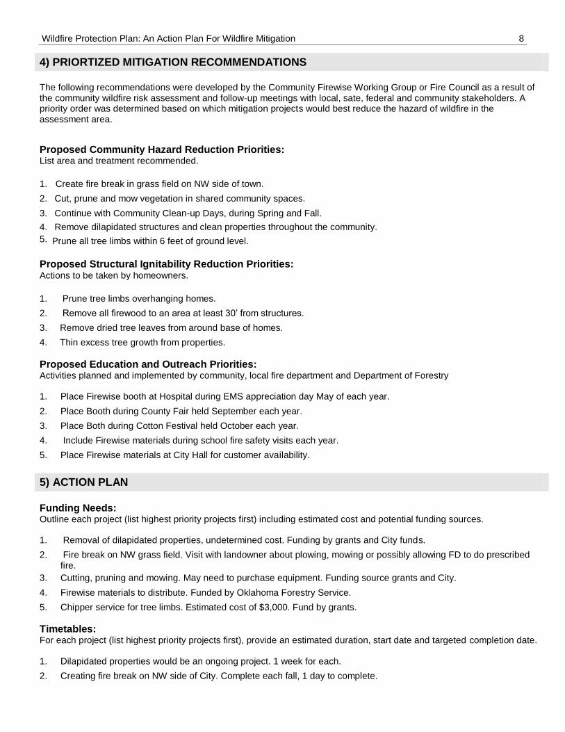
4) PRIORTIZED MITIGATION RECOMMENDATIONS
The following recommendations were developed by the Community Firewise Working Group or Fire Council as a result of the community wildfire risk assessment and follow-up meetings with local, sate, federal and community stakeholders. A priority order was determined based on which mitigation projects would best reduce the hazard of wildfire in the assessment area.
Proposed Community Hazard Reduction Priorities: List area and treatment recommended.
1. Create fire break in grass field on NW side of town.
2. Cut, prune and mow vegetation in shared community spaces.
3. Continue with Community Clean-up Days, during Spring and Fall.
4.
5.
Remove dilapidated structures and clean properties throughout the community.
Prune all tree limbs within 6 feet of ground level.
Proposed Structural Ignitability Reduction Priorities: Actions to be taken by homeowners.
1. Prune tree limbs overhanging homes.
2. Remove all firewood to an area at least 30’ from structures.
3. Remove dried tree leaves from around base of homes.
4. Thin excess tree growth from properties.
Proposed Education and Outreach Priorities: Activities planned and implemented by community, local fire department and Department of Forestry
1. Place Firewise booth at Hospital during EMS appreciation day May of each year.
2. Place Booth during County Fair held September each year.
3. Place Both during Cotton Festival held October each year.
4. Include Firewise materials during school fire safety visits each year.
5. Place Firewise materials at City Hall for customer availability.
5) ACTION PLAN
Funding Needs: Outline each project (list highest priority projects first) including estimated cost and potential funding sources.
1. Removal of dilapidated properties, undetermined cost. Funding by grants and City funds.
2. Fire break on NW grass field. Visit with landowner about plowing, mowing or possibly allowing FD to do prescribed fire.
3. Cutting, pruning and mowing. May need to purchase equipment. Funding source grants and City.
4. Firewise materials to distribute. Funded by Oklahoma Forestry Service.
5. Chipper service for tree limbs. Estimated cost of $3,000. Fund by grants.
Timetables: For each project (list highest priority projects first), provide an estimated duration, start date and targeted completion date.
1. Dilapidated properties would be an ongoing project. 1 week for each.
2. Creating fire break on NW side of City. Complete each fall, 1 day to complete.
Wildfire Protection Plan: An Action Plan For Wildfire Mitigation 9
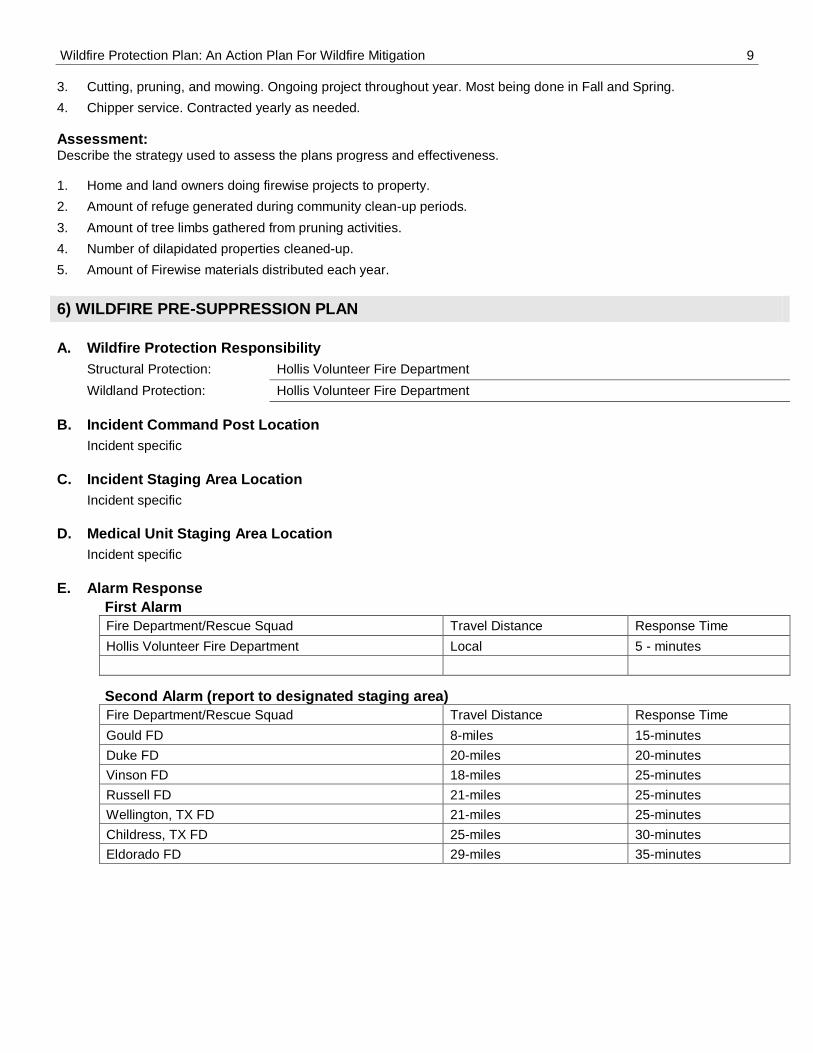
3. Cutting, pruning, and mowing. Ongoing project throughout year. Most being done in Fall and Spring.
4. Chipper service. Contracted yearly as needed.
Assessment: Describe the strategy used to assess the plans progress and effectiveness.
1. Home and land owners doing firewise projects to property.
2. Amount of refuge generated during community clean-up periods.
3. Amount of tree limbs gathered from pruning activities.
4. Number of dilapidated properties cleaned-up.
5. Amount of Firewise materials distributed each year.
6) WILDFIRE PRE-SUPPRESSION PLAN
A. Wildfire Protection Responsibility
Structural Protection: Hollis Volunteer Fire Department
Wildland Protection: Hollis Volunteer Fire Department
B. Incident Command Post Location
Incident specific
C. Incident Staging Area Location
Incident specific
D. Medical Unit Staging Area Location
Incident specific
E. Alarm Response
First Alarm
Fire Department/Rescue Squad Travel Distance Response Time
Hollis Volunteer Fire Department Local 5 - minutes
Second Alarm (report to designated staging area)
Fire Department/Rescue Squad Travel Distance Response Time
Gould FD 8-miles 15-minutes
Duke FD 20-miles 20-minutes
Vinson FD 18-miles 25-minutes
Russell FD 21-miles 25-minutes
Wellington, TX FD 21-miles 25-minutes
Childress, TX FD 25-miles 30-minutes
Eldorado FD 29-miles 35-minutes
Wildfire Protection Plan: An Action Plan For Wildfire Mitigation 10
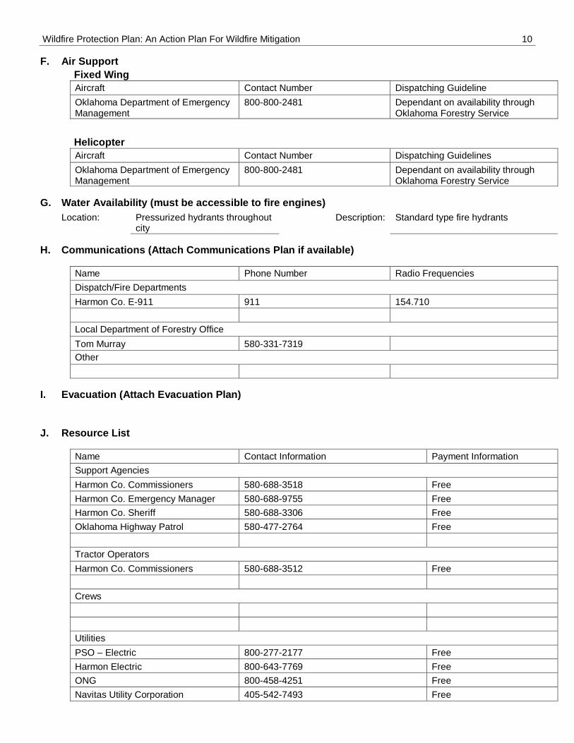
F. Air Support
Fixed Wing
Aircraft Contact Number Dispatching Guideline
Oklahoma Department of Emergency Management
800-800-2481 Dependant on availability through Oklahoma Forestry Service
Helicopter
Aircraft Contact Number Dispatching Guidelines
Oklahoma Department of Emergency Management
800-800-2481 Dependant on availability through Oklahoma Forestry Service
G. Water Availability (must be accessible to fire engines)
Location: Pressurized hydrants throughout city
Description: Standard type fire hydrants
H. Communications (Attach Communications Plan if available)
Name Phone Number Radio Frequencies
Dispatch/Fire Departments
Harmon Co. E-911 911 154.710
Local Department of Forestry Office
Tom Murray 580-331-7319
Other
I. Evacuation (Attach Evacuation Plan)
J. Resource List
Name Contact Information Payment Information
Support Agencies
Harmon Co. Commissioners 580-688-3518 Free
Harmon Co. Emergency Manager 580-688-9755 Free
Harmon Co. Sheriff 580-688-3306 Free
Oklahoma Highway Patrol 580-477-2764 Free
Tractor Operators
Harmon Co. Commissioners 580-688-3512 Free
Crews
Utilities
PSO – Electric 800-277-2177 Free
Harmon Electric 800-643-7769 Free
ONG 800-458-4251 Free
Navitas Utility Corporation 405-542-7493 Free
Wildfire Protection Plan: An Action Plan For Wildfire Mitigation 11
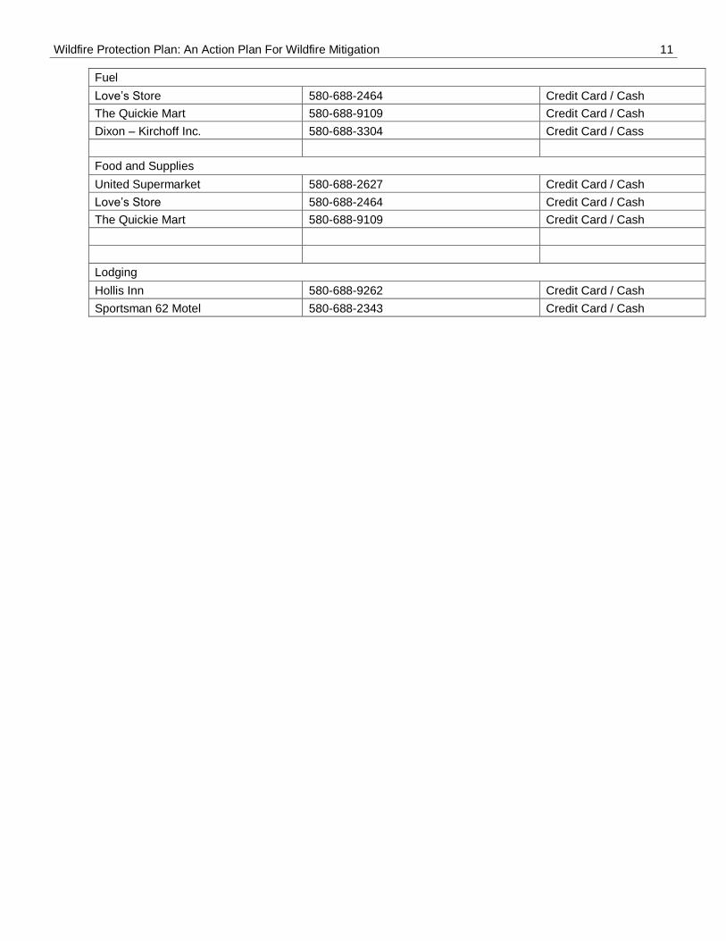
Fuel
Love’s Store 580-688-2464 Credit Card / Cash
The Quickie Mart 580-688-9109 Credit Card / Cash
Dixon – Kirchoff Inc. 580-688-3304 Credit Card / Cass
Food and Supplies
United Supermarket 580-688-2627 Credit Card / Cash
Wildfire Protection Plan: An Action Plan For Wildfire Mitigation 12
7) ADDITIONAL COMMENTS
As long as the current exceptional drought conditions exist within Harmon County, all firefighters must remain alert for wildland fires to occur. In order to save lives and property quick and aggressive firefighting tactics must be employed, but with firefighter safety being
the number 1 priority.
Wildfire Protection Plan: An Action Plan For Wildfire Mitigation 13
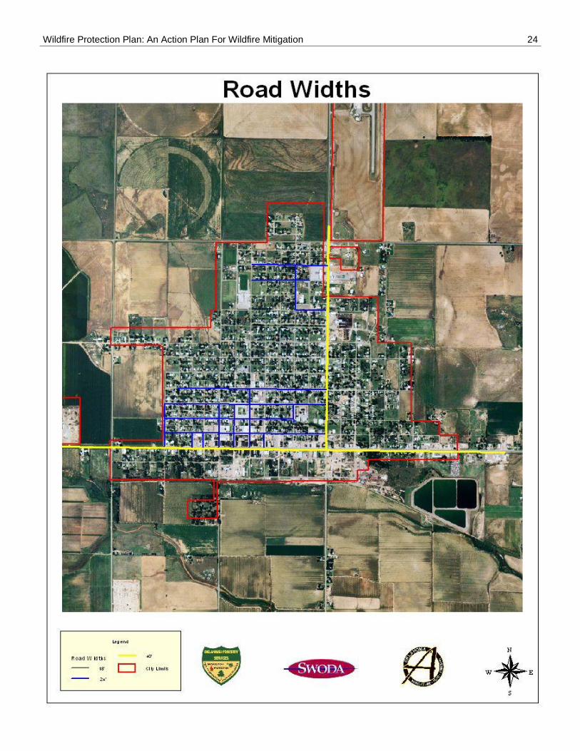
8) ATTACHMENTS (List here in order of attachment)
1. Community Wildfire Risk and Hazard Assessments – pages 14 through 20
2. Community Base Map – page 21
3. Interface Area Map – page 22
4. Assessment Map – page 23
5. Road Width Map – page 24
6. High Hazard Map – page 25
7. Fire Hydrant Map – page 25
Wildfire Protection Plan: An Action Plan For Wildfire Mitigation 14
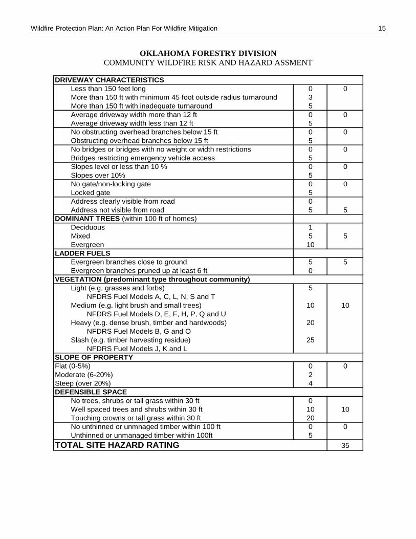
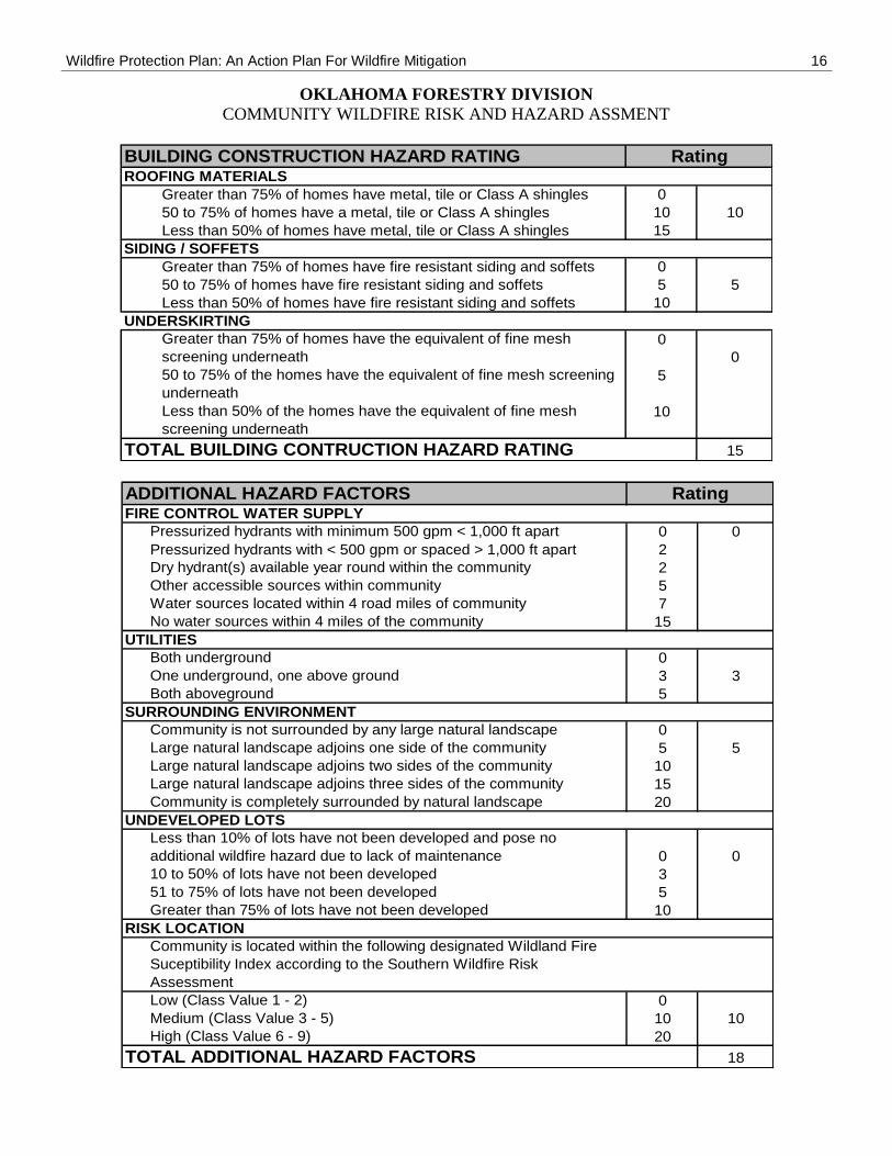
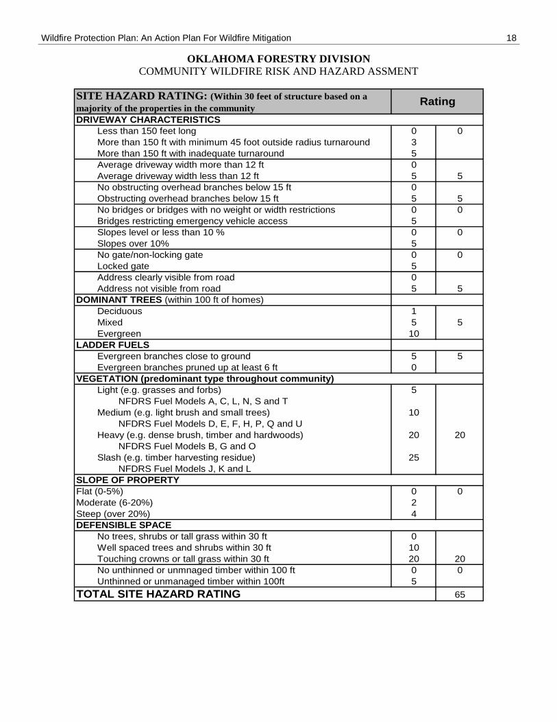
OKLAHOMA FORESTRY DIVISION
COMMUNITY WILDFIRE RISK AND HAZARD ASSMENT
Forestry Office: Burns Flat
Community: Hollis, North Assessment County: Harmon