Journal of Coastal Research SI 59 1-6 West Palm Beach, Florida 2011
The Coastal Modeling System Flow Model (CMS-Flow): Past and Present Christopher W. Reed†, Mitchell E. Brown‡, Alejandro Sánchez‡, Weiming Wu§, and Adele M. Buttolph††
ABSTRACT REED, C.W.; BROWN, M.E.; SANCHEZ, A.; WU, W., and BUTTOLPH, A.M., 2011. The Coastal Modeling System Flow Model (CMS-Flow): Past and Present. In: Roberts, T.M., Rosati, J.D., and Wang, P. (eds.), Proceedings, Symposium to Honor Dr. Nicholas C. Kraus, Journal of Coastal Research, Special Issue, No. 59, pp. 1-6. West Palm Beach (Florida), ISSN 0749-0208. CMS-Flow is a coupled time-dependent circulation, sediment transport and morphodynamic model based on the numerical solution of the mass, momentum and transport equations on a Cartesian (quad-tree) grid network with both explicit and implicit solvers. It has been developed and is currently supported under the Coastal Inlets Research Program (CIRP) conducted at the U.S. Army Engineer Research and Development Center (ERDC), Coastal and Hydraulics Laboratory (CHL). The model’s primary function is to support multi-disciplinary research teams and conduct practical projects at coastal inlets. CMS-Flow has been designed with a relatively simple code structure which allows for rapid development and inclusion of new sediment transport algorithms, while always being accessible to the general modeling community, including both USACE and commercial users. Today, CMS-Flow is an integral component of the CIRP, providing technology for simulating hydrodynamics, waves, sediment transport and morphology for short and long timeframes in coastal inlets, adjacent beaches, navigation channels and bays. ADDITIONAL INDEX WORDS: Coastal hydrodynamics, sediment transport, morphodynamic modeling.
INTRODUCTION
CMS-Flow is a coupled time-dependent circulation, sediment
transport and morphodynamic model that can be configured for both 2D and 3D simulations. The model is based on the numerical solution of the mass, momentum and transport equations on a Cartesian grid network with both explicit and implicit solution schemes available. The circulation model component supports spatially variable and time dependent wind, tide, atmospheric pressure, flow and wave radiation stress forcing, salinity transport and includes special features such as flooding and drying, spatially variable bottom friction, representation of flow control structures, and advanced boundary condition treatments. Sediment transport is forced by the circulation model derived currents and waves derived from the coupled CMS-Wave model (Lin et al., this issue). Various bedload and suspended load models such as Lund-CIRP and Watanabe formulations are available via user options. Recently, a non-equilibrium transport formulation was included in the model (Sanchez et al., this issue) and sediment avalanching, hard-bottom and breaching algorithms were added. The
hydrodynamic and sediment transport models are coupled via a morphodynamic module that calculates time-dependent changes in the bed elevation due to the simulated sediment transport. The hydrodynamic grid is then updated to reflect the depth changes, which then completes the coupling.
CMS-Flow has been developed and is currently supported under the Coastal Inlets Research Program (CIRP) conducted at the U.S. Army Engineer Research and Development Center (ERDC), Coastal and Hydraulics Laboratory (CHL). The model’s primary function is to support multi-disciplinary research teams and conduct practical projects at coastal inlets. CMS-Flow has been applied at numerous coastal inlets and examined extensively through sensitivity testing. It has been designed with a relatively simple code structure which allows for rapid development and inclusion of new sediment transport technologies, while always being accessible to the general modeling community, including both USACE and commercial users.
CMS-Flow is supported with the Surfacewater Modeling System (SMS) software package, which provides a graphical user interface for model setup, running and post-processing. Details of the theory and numerical implementation can be found in the CMS-Flow technical reports (Milletello et al., 2004; Buttolph et al., 2006) and a description of the graphical interface can be found in the SMS literature (Zundel, 2000).
†URS Corporation 1625 Summit Lake Drive Tallahassee, FL 32317, USA [email protected] ‡U.S. Army Engineer Research & Development Center, 3909Halls Ferry Road Vicksburg, MS 39180-6199, USA
§National Center for Computational Hydroscience and Engineering, University of Mississippi, University, MS, 28677, USA ††Coastal Analysis LLC, 29 Valley Heights Drive, Enterprise, OR 97828, USA
www.cerf-jcr.org
Report Documentation Page Form ApprovedOMB No. 0704-0188
Public reporting burden for the collection of information is estimated to average 1 hour per response, including the time for reviewing instructions, searching existing data sources, gathering andmaintaining the data needed, and completing and reviewing the collection of information. Send comments regarding this burden estimate or any other aspect of this collection of information,including suggestions for reducing this burden, to Washington Headquarters Services, Directorate for Information Operations and Reports, 1215 Jefferson Davis Highway, Suite 1204, ArlingtonVA 22202-4302. Respondents should be aware that notwithstanding any other provision of law, no person shall be subject to a penalty for failing to comply with a collection of information if itdoes not display a currently valid OMB control number.
1. REPORT DATE 2011 2. REPORT TYPE
3. DATES COVERED 00-00-2011 to 00-00-2011
4. TITLE AND SUBTITLE The Coastal Modeling System Flow Model (CMS-Flow): Past and Present
5a. CONTRACT NUMBER
5b. GRANT NUMBER
5c. PROGRAM ELEMENT NUMBER
6. AUTHOR(S) 5d. PROJECT NUMBER
5e. TASK NUMBER
5f. WORK UNIT NUMBER
7. PERFORMING ORGANIZATION NAME(S) AND ADDRESS(ES) U.S. Army Engineer Research and Development Center,Coastal andHydraulics Laboratory,3909 Halls Ferry Road,Vicksburg,MS,39180
8. PERFORMING ORGANIZATIONREPORT NUMBER
9. SPONSORING/MONITORING AGENCY NAME(S) AND ADDRESS(ES) 10. SPONSOR/MONITOR’S ACRONYM(S)
11. SPONSOR/MONITOR’S REPORT NUMBER(S)
12. DISTRIBUTION/AVAILABILITY STATEMENT Approved for public release; distribution unlimited
13. SUPPLEMENTARY NOTES
14. ABSTRACT CMS-Flow is a coupled time-dependent circulation, sediment transport and morphodynamic model basedon the numerical solution of the mass, momentum and transport equations on a Cartesian (quad-tree) gridnetwork with both explicit and implicit solvers. It has been developed and is currently supported under theCoastal Inlets Research Program (CIRP) conducted at the U.S. Army Engineer Research and DevelopmentCenter (ERDC), Coastal and Hydraulics Laboratory (CHL). The model?s primary function is to supportmulti-disciplinary research teams and conduct practical projects at coastal inlets. CMS-Flow has beendesigned with a relatively simple code structure which allows for rapid development and inclusion of newsediment transport algorithms, while always being accessible to the general modeling community,including both USACE and commercial users. Today, CMS-Flow is an integral component of the CIRP,providing technology for simulating hydrodynamics, waves, sediment transport and morphology for shortand long timeframes in coastal inlets, adjacent beaches, navigation channels and bays.
15. SUBJECT TERMS
16. SECURITY CLASSIFICATION OF: 17. LIMITATION OF ABSTRACT Same as
Report (SAR)
18. NUMBEROF PAGES
6
19a. NAME OFRESPONSIBLE PERSON
a. REPORT unclassified
b. ABSTRACT unclassified
c. THIS PAGE unclassified
Standard Form 298 (Rev. 8-98) Prescribed by ANSI Std Z39-18
2 Reed, et al. _________________________________________________________________________________________________
Journal of Coastal Research, Special Issue No. 59, 2011
BACKGROUND
CMS-Flow began in 1994 as a 1D hydrodynamic model, developed by Adele Militello as a class project taught by Dr. Don Resio at Florida Institute of Technology and was called M2D. With guidance by her advisor, Dr. Gary Zarillo, and continued support from Dr. Resio, the model was extended to two dimensions. The numerical solution was explicit and employed a Cartesian grid, both relatively simple numerical approaches which today still represent the underlying philosophy behind CMS-Flow: to provide a modeling system that would be easy for users to set up and apply, code that was readily understandable for developers, code that was easy to work within and modify, and excellent performance on numerical integrity tests. CMS-Flow is designed to provide an efficient means to develop and test new transport algorithms and allow for validated technologies to be immediately available to the user community.
While studying at Florida Institute of Technology, Militello took a position at Texas A&M University at Corpus Christi to work with Dr. Nick Kraus. The first application of the M2D model was to the Lower Laguna Madre, Texas. However, no interface for grid development was available, so the numerical grid was completely hand-edited after being sketched out on about 8 feet of paper, and took about three weeks to complete.
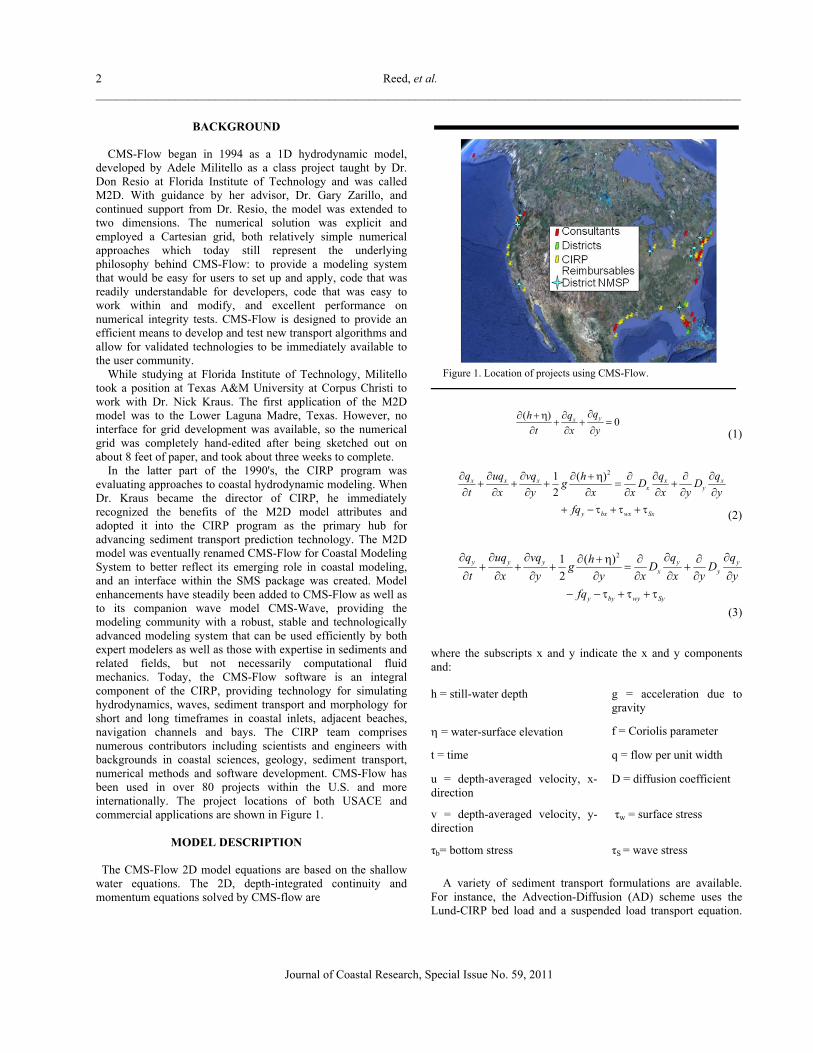
In the latter part of the 1990's, the CIRP program was evaluating approaches to coastal hydrodynamic modeling. When Dr. Kraus became the director of CIRP, he immediately recognized the benefits of the M2D model attributes and adopted it into the CIRP program as the primary hub for advancing sediment transport prediction technology. The M2D model was eventually renamed CMS-Flow for Coastal Modeling System to better reflect its emerging role in coastal modeling, and an interface within the SMS package was created. Model enhancements have steadily been added to CMS-Flow as well as to its companion wave model CMS-Wave, providing the modeling community with a robust, stable and technologically advanced modeling system that can be used efficiently by both expert modelers as well as those with expertise in sediments and related fields, but not necessarily computational fluid mechanics. Today, the CMS-Flow software is an integral component of the CIRP, providing technology for simulating hydrodynamics, waves, sediment transport and morphology for short and long timeframes in coastal inlets, adjacent beaches, navigation channels and bays. The CIRP team comprises numerous contributors including scientists and engineers with backgrounds in coastal sciences, geology, sediment transport, numerical methods and software development. CMS-Flow has been used in over 80 projects within the U.S. and more internationally. The project locations of both USACE and commercial applications are shown in Figure 1.
MODEL DESCRIPTION
The CMS-Flow 2D model equations are based on the shallow
water equations. The 2D, depth-integrated continuity and momentum equations solved by CMS-flow are
Figure 1. Location of projects using CMS-Flow.
(1)
(2)
(3)
where the subscripts x and y indicate the x and y components and:
h = still-water depth g = acceleration due to gravity
= water-surface elevation f = Coriolis parameter
t = time q = flow per unit width
u = depth-averaged velocity, x-direction
D = diffusion coefficient
v = depth-averaged velocity, y-direction
τw = surface stress
τb= bottom stress τS = wave stress
A variety of sediment transport formulations are available.
For instance, the Advection-Diffusion (AD) scheme uses the Lund-CIRP bed load and a suspended load transport equation.
( )0yx
qqh
t x y
21 ( )
2x x x x x
x y
y bx wx Sx
q uq vq q qhg D D
t x y x x x y y
fq
21 ( )
2y y y y y
x y
y by wy Sy
q uq vq q qhg D D
t x y y x x y y
fq
Coastal Modeling System Flow Model (CMS-Flow) 3 _________________________________________________________________________________________________
Journal of Coastal Research, Special Issue No. 59, 2011
The bed load formulation was developed by Camenen and Larson (2005):
, (4)
where qbc = bed load d50= median grain size
θcw,m = mean wave-current Shields parameter stress
an,b = model coefficients
θc = current Shields parameter s = specific gravity of sediment
θcw = maximum wave-current Shields parameter
θcr = critical Shields parameter
and the AD equation is:
(5)
where C = depth-averaged sediment concentration
K = sediment diffusion coefficient
d = total water depth D = sediment deposition rate
P = sediment pick-up rate The sediment continuity equation is solved to compute depth change
(6)
where Qx and Qy are bed load in the x and y directions, p is the sediment porosity and h is the bottom elevation.
This brief description of the governing equations provides the general mathematical basis for the CMS model. The detailed description of the governing equations, parameter definitions, numerical solution schemes and additional algorithms are available in the referenced report. The formulations for the 3D module are available in the draft model report (Reed et al., 2007).
RECENT MODEL ENHANCEMENTS
Three key components inherent in choosing and developing a
model in practice are:
Capabilities Reliability Computational Speed
In any coastal modeling application it is critical to use a model that can represent the important and controlling physical processes and controls on the system. These can range from fundamental processes such as cohesion to the ability to represent spatially variable wind effects. It is also important that the model is reliable, and can be setup and applied with the confidence that a stable simulation can be obtained without spurious results or the need for tedious and continual grid modifications. Finally, despite the processing speeds of modern computers, the desire to include more refined models with more detailed physics has, and always will, push the limits of available computational resources.
Enhancements to the CMS-Flow model are made regularly to improve the model capabilities, reliability and computational efficiency. Typically in model development, the time required for a new model feature to be supported by the GUI (i.e. SMS) so that the general users can access the features may take six months to a year. In order to reduce the time for new features to become available, the advanced card option has been implemented in the SMS GUI. The advanced card option allows the user to enter special commands to the CMS-Flow model in a special SMS menu and these commands will be read by the CMS-Flow code and control the model response. The menu structure is static, but will accommodate new commands as they are added to the model code. These features allow the code developers to add new or experimental features without requiring a corresponding update to the SMS. The advanced cards have been used to add additional friction algorithms, diffusion algorithms, avalanching schemes, flow structures, multiple grain size simulations, and multiple processor capabilities. Eventually, the capabilities added with the advanced cards are supported by SMS. An example of recent capabilities added to the CMS-Flow using the advanced cards are a variety of flow structures, including weirs, culverts, pilings, tidal gates and porous rubble mounds.
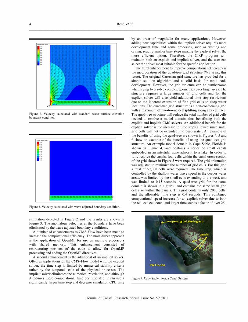
An example of a model enhancement developed to improve the model reliability is the wave adjusted boundary condition (Reed, 2005). In the nearshore, the wave-induced longshore current and setup are dominant hydrodynamic processes, and lateral boundary conditions representing tide and oceanic forcing will not include corresponding surface-wave contributions. Without proper boundary conditions, significant gradients in current and water level can occur that contaminate the solution in the internal domain. This situation is depicted in Figure 2. A standard strategy in such situations is to place the boundaries far from the site of interest, but this strategy greatly increases computer resource requirements and run time, and it may not be appropriate for long-term simulations. A wave-adjusted boundary condition that accounts for wave-induced water level and current acting in combination with tidal forcing has been developed and implemented in CMS-Flow. The approach consists of solving the one-dimensional (1D) continuity and momentum equations containing the radiation-stress gradients along the axis normal to the boundary. Wave-induced setup along this axis is added to the prescribed water-elevation boundary forcing values to provide consistent water elevation values at the boundary and in the grid interior, which subsequently eliminates anomalous velocities. The effect of the wave adjusted boundary conditions have been applied to the
4 Reed, et al. _________________________________________________________________________________________________
Journal of Coastal Research, Special Issue No. 59, 2011
Figure 2. Velocity calculated with standard water surface elevation boundary condition.
Figure 3. Velocity calculated with wave-adjusted boundary condition.
simulation depicted in Figure 2 and the results are shown in Figure 3. The anomalous velocities at the boundary have been eliminated by the wave adjusted boundary conditions.
A number of enhancements to CMS-Flow have been made to increase the computational efficiency. The most direct approach is the application of OpenMP for use on multiple processors with shared memory. This enhancement consisted of restructuring portions of the code to allow for OpenMP processing and adding the OpenMP directives.
A second enhancement is the additional of an implicit solver. Often in applications of the CMS–Flow model with the explicit solver, the time step is limited by numerical stability criteria rather by the temporal scale of the physical processes. The implicit solver eliminates the numerical restriction, and although it requires more computational time per time step, it can use a significantly larger time step and decrease simulation CPU time
by an order of magnitude for many applications. However, adding new capabilities within the implicit solver requires more development time and some processes, such as wetting and drying, require smaller time steps making the explicit solver the more efficient option. Therefore, the CIRP program will maintain both an explicit and implicit solver, and the user can select the solver most suitable for the specific application.
The third enhancement to improve computational efficiency is the incorporation of the quad-tree grid structure (Wu et al., this issue). The original Cartesian grid structure has provided for a simple solution algorithm and a solid basis for rapid code development. However, the grid structure can be cumbersome when trying to resolve complex geometries over large areas. The structure requires a large number of grid cells and for the explicit solver will also yield additional time step restrictions due to the inherent extension of fine grid cells to deep water locations. The quad-tree grid structure is a non-conforming grid with a maximum of two-to-one cell splitting along any cell face. The quad-tree structure will reduce the total number of grid cells needed to resolve a model domain, thus benefitting both the explicit and implicit CMS solvers. An additional benefit for the explicit solver is the increase in time steps allowed since small grid cells will not be extended into deep water. An example of the benefits of using the quad-tree are shown in Figures 4, 5 and 6 show an example of the benefits of using the quad-tree grid structure. An example model domain in Cape Sable, Florida is shown in Figure 4, and contains a series of small canals embedded in an intertidal zone adjacent to a lake. In order to fully resolve the canals, four cells within the canal cross-section of the grid shown in Figure 5 were required. The grid orientation was adjusted to minimize the number of grid cells. For this grid a total of 57,000 cells were required. The time step, which is controlled by the shallow water wave speed in the deeper water areas, was limited by the small cells extending to the west, and was limited to 0.15 seconds. A quad-tree grid for the same domain is shown in Figure 6 and contains the same small grid cell size within the canals. This grid contains only 2000 cells, and the allowable time step is 0.4 seconds. This combined computational speed increase for an explicit solver due to both the reduced cell count and larger time step is a factor of over 25.
Figure 4. Cape Sable Florida Canal System.
Coastal Modeling System Flow Model (CMS-Flow) 5 _________________________________________________________________________________________________
Journal of Coastal Research, Special Issue No. 59, 2011
MODEL VALIDATIONS
Despite the push for rapid development and application of new technology, each component of the CMS–Flow model is rigorously tested prior to being released for general use. The testing includes both model calibration and validation using analytical, laboratory and field data and testing on a set of standard bench test cases. This second set of tests is required to assure that the new modules function properly within all existing forcing and boundary conditions and that their implementation has not compromised existing modules and functionality. The classic calibrations and validations are used to set model parameter values, or ranges for those parameter values, and assesses the model accuracy and reliability.
Figure 5. Cartesian Grid covering canals and opening to lake.
Figure 6. Quad-tree grid covering canals and opening to lake.
As an example, Figure 7 shows the validation of the CMS-Flow model response to wave forcing, calculations were compared to laboratory data collected by Visser (1982). The CMS-Flow model was coupled with the CMS-Wave model using the SMS interface to develop these simulations. This calibration was used to validate the surf-zone diffusion module.
As a second example, Figure 8 shows the comparison of the model simulation of cross-channel transport and morphology changes compared to the data of Galappatti and Vreugdenhil (1985). The test case represents a 51 cm/s cross-channel flow over a 39 cm deep channel with an initial side slope of 1:10 and 0.16 mm sand particles. These comparisons were used to determine the adaptation length scale in the non-equilibrium sediment transport formulation.
Figure 7. Comparison of CMS-Flow to data of Visser (1985).
Figure 8 Calibration of the Non-Equilibrium Sediment Transport Algorithm.
SUMMARY
The CMS-Flow model has become an integral component of the CIRP. When coupled with the companion wave model CMS-Wave (Lin et al., this issue) the CMS model provides a stable and robust computational-based analysis tool for simulating complex sediment transport and morphologic response of inlets, beaches and navigation channels to forcing by tides, winds, river flows and waves.
6 Reed, et al. _________________________________________________________________________________________________
Journal of Coastal Research, Special Issue No. 59, 2011
ACKNOWLEDGMENTS
The authors are grateful to Dr. Nicholas C. Kraus for his continual support and encouragement for many years towards development and improvement of the capabilities of CMS-Flow to increase reliability of wave modeling for coastal inlets and navigation applications. Permission was granted by the Chief, U. S. Army Corps of Engineers to publish this information.
LITERATURE CITED
Buttolph, A. M.; Reed, C. W.; Kraus, N. C.; Ono, N.; Larson,
M.; Camenen, B.; Hanson, H.; Wamsley, T. and Zundel, A. K., 2006. Two-Dimensional Depth-Averaged Circulation Model CMS-M2D: Version 3.0, Report 2, Sediment Transport and Morphology Change. ERDC/CHL-TR-06-7. Vicksburg, Mississippi, US Army Engineer Research and Development Center, 156 p.
Camenen, B., and Larson, M., 2005. A bedload sediment transport formula for the nearshore. Estuarine, Coastal and Shelf Science, 63, 249-260.
Militello, A.; Reed, C. W.; Zundel, A. K., and Kraus, N. C., 2004. Two-dimensional depth-averaged circulation model M2D: Version 2.0, Report 1: Documentation and user’s
guide. ERDC/CHL TR-04-02, Vicksburg, Mississippi: US Army Engineer Research and Development Center, 128p.
Nishimura, H., 1988. Computation of neasrshore current. In: K.Horikawa (ed.), Nearshore dynamics and coastal processes. Tokyo, Japan: University of Tokyo Press, pp. 271-291.
Reed, C. W. and Militello, A., 2005. Wave-adjusted boundary condition for longshore current in finite-volume circulation models. Ocean Engineering, 32, 2121-2134.
Reed, C.W.; Buttolph, A.M.; Kraus, N.C.; Rosati, J.D., and Zundel, A.K., 2007. Coastal Modeling System (CMS): Report 3, three-dimensional capability in hydrodynamics, sediment transport, and morphologychange. ERDC/CHL TR-07-xx, Vicksburg, Mississippi: US Army Engineer Research and Development Center, 168p.
Galappatti, R. and Vreugdenhil, C.B., 1985. A depth-integrated model for suspended transport. Journal of Hydraulic Research, 23(4), 359-377.
Visser, P. J., 1982. Uniform longshore current measurements and calculations. 19th Coastal Engineering Conference, ASCE, 2,192-2,207.
Zundel, A. K., 2000. Surface-water Modeling System reference manual, Provo, Utah: Brigham Young University, Environmental Modeling Research Laboratory.