33 IGC excursion No 48, August 15 – 21, 2008 The Cu-Ni-PGE and Cr deposits of the Monchegorsk area, the Kola Peninsula, Russia Organizers: Yury L. Voytekhovsky, Yury N. Neradovsky, Geological Institute, Kola Science Centre, Russian Academy of Science (Apatity, Russia)
Transcript
33 IGC excursion No 48, August 15 – 21, 2008
The Cu-Ni-PGE and Cr deposits of the Monchegorsk area, the Kola Peninsula,
Russia Organizers: Yury L. Voytekhovsky, Yury N. Neradovsky, Geological Institute, Kola Science Centre, Russian Academy of Science (Apatity, Russia)
-2-
Table of contents INTRODUCTION .......................................................................................................... 3
Geology of the Monchegorsk area .......................................................................... 4 The Monchepluton and associated deposits .............................................................................................. 6 Mineral composition of the ores ................................................................................................................. 8
The ore prospects of the contact zone................................................................................................ 9 The ore deposits and ore prospects of the endocontact zone ............................................................ 9 The ore deposits and ore prospects in plagioclase-bearing harzburgite and harzburgite .................. 9 The ore deposits of the zone of alternating pyroxenite and peridotite .............................................. 10 The ore deposits and ore prospects in pyroxenite ............................................................................. 10 The ore deposits and ore prospects in norite ..................................................................................... 11 The ore deposits and ore prospects in gabbronorite .......................................................................... 11 Monchetundra massif ........................................................................................................................ 11
The Imandra lopolith .................................................................................................................................. 12 Petrology of the intrusive rocks .................................................................................................................. 14 Daily description of the excursion ................................................................................. 15
August 15th, Friday ........................................................................................................................... 15 August 16th, Saturday ....................................................................................................................... 15 August 17th, Sunday ......................................................................................................................... 15 August 18th, Monday ........................................................................................................................ 16 August 19th, Tuesday ........................................................................................................................ 16 August 20th, Wednesday ................................................................................................................... 16 August 21st, Thursday ....................................................................................................................... 17
The description of the stops and outcrops ................................................................... 17 The Monchepluton .................................................................................................................................... 17
Stop 1. Cu-Ni disseminated ore of the NKT near-bottom zone .................................................... 17 Stop 2. Cu-Ni veined ores of the NKT massif ...................................................................... 20 Stop 3. Cr ore of the Sopcheozero deposit .................................................................................... 23 Stop 4. Cu-Ni ore of “Horizon 330” .............................................................................................. 26 Stop 5. Cu-Ni ore of the “Critical horizon” ................................................................................... 29 Stop 5-а. Сu-Ni of the “Terrace” deposit ......................................................................................... 29 Stop 6. Pt-Pd ore of the “Vurechuaivench” deposit .................................................................................... 30
The Imandra lopolith. ........................................................................................................... 32 Stop 1. Cr ore of Mt. Majyavr-Devich’ya ........................................................................................ 32 Stop 2. Cr ore of the Bolshaya Varaka deposit ................................................................................ 33
Introduction The excursion route embraces eight outcrops close to the town of Monchegorsk and one outcrop near the town of Apatity (Fig.a – cover). The participants of the excursion are to be accommodated at the hotel at the Imandra lakeside. The geological excursion to the deposits of the Monchegorsk ore field (the Kola Peninsula) is intended for geologists of broad interests, but mainly for mining geologists. The excursion aims at examining the genesis settings of Cu-Ni, Cr and PGE ore related to the layered mafic-ultramafic massifs intruded into the supracrustal Archean complexes at the 2500-2400 Ma boundary and marked the productive phase of mantle plume activity at the Archean-Proterozoic boundary (Fig. 1). The Monchegorsk pluton and the Imandra lopolith are the typical representatives of the Paleoproterozoic ore-bearing
Fig. 1. Generalized geological map of the north-eastern part of the Fennoscandian Shield showing the location of the early Palaeoproterozoic ca. 2440 Ma old
layered intrusions. Modified after Alapieti et al. (1990); Iljina M(1994).
-4-
layered intrusions on the Fennoscandian Shield, and due to the nice exposures and availability they are also unique sites for investigation. Geology of the Monchegorsk area The Monchegorsk ore region is located between the Kola and Belomorian Archean domains (Fig. 2). The area is characterized by the voluminous Early Proterozoic mafic-ultramafic magmatism. Its effusive species comprise more than 90% of the total volcanic-sedimentary
Fig.2 The geological map of the Monchegorsk ore field compiled at the Geological Institute KSC RAS with the use of the materials provided by the industrial organizations, 2003.
Legend: 1 – large gabbro-dolerite dykes; 2 – anatectite-granite and trondhjemite; 3 – metagabbroids of the Imandra lopolith; 4-5 – metavolcanics (4), quarzites and shists (5) of the Kuksha and Seidorehcka Fms of the Imandra-Varzuga zone; 6 – lherzolite, websterite, orthopyroxenite (а) and gabbronorite of the Ostrovsky Lake massif; 7 – troctolite; 8 – large norite, orthopyroxenite and gabbro dykes; 9 – gabbro-anorthosite of the Chuna-tundra massif; 10-11 – metagabbro, gabbronorite (10) and alternating orthopyroxenite and norite (11) of the Monche-tundra massif; 12 – blastocataclasite mainly after Chuna- and Monche-tundra gabbroids, and after amphibolite, gneiss and diorite of the Archean complex; 13 – Yarva-Varaka norite, diorite and granophyre quarzt diorite; 14 – Vurechuaivench Foothills metagabbro, gabbronorite and anorthosite; 15 – Monchepluton olivine norite, norite, gabbronorite (Nyud-Poaz); 16 – Monchepluton peridotite, pyroxenite (а) and dunite (б) (NKT); 17 – diorite (а) and metagabbro (б) of the 10th anomaly; 18-23 – Archean complex: 18 – diorite, granodiorite, 19 – Archean acid volcanics and metasediments of Arvarench Mt., 20 – schistose amphibolite of the Vite-guba Fm, 21-23 – high-alumina (21), garnet-biotite (22) and biotite-amphibole (23) gneiss; 24 – tectonic dislocations; 25 – strike and fault; 26 – deep record borehole.
-5-
rocks of the Paleoproterozoic Imandra-Varzuga rift belt. Intrusive facies is represented by the three layered complexes, which are the Monchepluton, Mochetundra massif and Imandra intrusion, and a number of small mafic-ultramafic intrusions. Mafic dykes occupy about 5% of the Archean basement. The Imandra-Varzuga structure is the part of the Paleoproterozoic Pechenga-Varzuga rift belt, extending through the whole Kola Peninsula from the White Sea Throat to the Norwegian Caledonides. Supracrustal volcano-sedimentary rocks form graben-like asymmetric troughs up to 40 m wide and up to 7 km deep. Asymmetric structure is a result of the position between the hard Kola and remobilized Belomorian Archean domains. In the north-east limb of the trough, the Proterozoic units overlay the Archean basement in the same direction with angular unconformity, weathering crust and basal conglomerates. In contrast, in the south-west limb, a contact between the Proterozoic and Archean rocks, appears to be obscure because of the strong dislocation and metamorphic alteration. The Early Proterozoic Pechenga-Varzuga volcano-sedimentary complex as a whole represents the Pechenga Supergroup comprising the five groups: Sumi, Sariola, Jatuli, Ludia, and Kaleva (Zagorodny, Radchenko, 1988), which stratotypes occur mostly in Karelia (Semikhatov et al., 1991). Sumi includes the three Formations: Purnacha, Kuksha and Seidorechka, that are abundant only within the Imandra-Varzuga structure. The Purnacha Fm has tectonic contact with the Archean basement rocks and extends for 135 km along the north border of the trough in the eastern part of the zone. The thickness reaches 1500 m. It consists mainly of tholeitic metabasalts with lenses of shallow cross-bedded carboniferous psammites up to 100-200 m thick. The Kuksha Fm transgressively overlaps the Purnacha Fm in the eastern part of the zone, and lies on the Archean basement rocks in the west. Polymict conglomerates, intercalating with arkoses and gritstones and covered by arkosic sandstones with carbonaceous cement, are represented in the base of the section. Overlaying metabasalts composed of slightly differentiated low-Ca tholeites and compositionally closed to the metabasalts of the Purnacha Fm, dominate within the section. In the Monchegorsk area, metabasalts of the Kuksha Fm directly occur on the weathering surface of the Archean rocks or are separated from them by a thin layer of deluvial breccia and conglomerates with the residues of redeposited weathering crust. The total thickness of the formation is 1200-1300 m. The Seidorechka Fm occurrs conformably on the weathered surface (caused by halmyrolysis) of the Kuksha Fm volcanites. The lower terrigenous part of the section up to 500 m thick is composed of sericitic schists (hydromicaceous pelites), feldspar quartzites, chlorite-quartz (montmorillonitic pelites), and tuffites. Volcanogenic units of the section are subdivided into the three zones: Lower - high-Mg basalts and basaltic andesites up to 800 m thick, Middle - basaltic andesites (1500 m), and Upper zone - rhyodacites (up to 1000 m). Sariola in contrast to Sumi spreads along the whole Pechenga-Varzuga belt. It is represented by the Polisarka Fm within the Imandra-Varzuga zone. Its volcanic rocks directly overlie the eroded surface of the felsic volcanites of the Seidorechka Fm or are separated from them by a sedimentary horizon of polymict conglomerates, fine-rhythmical metaaleuropsammites including fragments of the Seidorechka volcanites, and sericitic schists (hydromicaceous pelites). Westwards, the psephytic facies changes into the pelitic one. The volcanogenic unit of the Polisarka Fm has a thickness of up to 300-1000 m. Lavas prevail within the section.
-6-
Pyroclastic material comprises less than 5% of the rock sequence. Thickly bedded lithoclastic psephitic tuffs are established in the basement. High-Mg basalts make up most of the section; basaltic andesites lie above. Lavas show typical ball textures, indicating submarine volcanic eruption. Jatuli is represented by the Umba Fm of basalts and basaltic andesites of subalkaline series with a carboniferous-terrigenous horizon in the basement of the Imandra-Varzuga section. It conformably overlies the rocks of the Polisarka Fm, but is not widespread due to pinching out in the Khibina area and completely absent in the Monchegorsk region. The total thickness of the Umba Fm is 1500 m. Ludia is composed of the rocks of black shale formation, tholeitic basalts and rarely of ferropicrobasalts, which form the core of the Imandra-Varzuga graben-syncline in its western part. Stratigraphic sequence is not clear, as the thickness and relationships between the rocks of the Il'mozero, Mitrijarvi and Solenoozero Fms are still not ascertained. Westwards, the rocks conformably overlay the Polisarka Fm volcanites. The lower part of the section includes mottled volcanogenic-terrigenous rocks: pelites, aleurolites, black schists, dolomites, and quartzites with rare layers of tholeitic basalts (the Solenoozero Fm) up to 2 km thick. The volcanogenic series of tholeitic basalts and ferropicrobasalts with chlorite, sulphide-carboniferous schists and sandstones between the volcanic layers occur up the section. Kaleva includes the Panarechenka and Saminga Fms, which rocks form an oval caldera-like structure in the central part of the Imandra-Varzuga zone. According to the rock composition and sequences, the Panarechenka Fm resembles that of Ludia. The Saminga Fm is represented by felsic volcanites mostly. All the rocks of the Pechenga Supergroup have undergone zonal regional metamorphism of greenschist facies in the central parts of the Imandra-Varzuga zone and of epidote-amphibolitic and amphibolitic facies in the flanks. The age of the Pechenga Supergroup is 2453 - 1765 Ma (Balashov, 1996). Intrusive complexes Layered intrusions of the Monchegorsk region occupy the same structural position as the supracrustal units, being located between the Archean domains and tracing this boundary even outside the Imandra-Varzuga zone. They are confined to the submeridional transform fault dislocating the Pechenga and Imandra-Varzuga parts of the Pechenga-Imandra-Varzuga volcanic belt. The Monchepluton and associated deposits The Monchegorsk pluton or Monchepluton belongs to the Kola Province of PGE-bearing layered intrusions (Mitrofanov et al., 1994). The U-Pb age of the pluton is 2509-2487 Ma (Smolkin et al., 2001). It occurrs in gneisses of the Kola-Belomorian complex and diorites with the age of 2932-2630 Ma (Balashov et al., 1993). The exposed area of the Monchepluton rocks is more than 60 km2. It takes a horseshoe shape in plane. The meridional branch up to 7 km long is marked out by Mts. Nittis, Kumuzh'ya and Travyanaya (NKT), and lattitudinal branch up to 9 km long - by Mts. Sopcha, Nyud and Poaz. The bottom of the both branches has a shape of symmetric trough, and plunges westwards, where the branches of the Monchepluton are jointed (Fig. 3). The general structure is affected by the south-east part of the pluton,
-7-
Fig.3 Geological sketch map and cross-sections of the Monchepluton with isotope U-Pb data of the intrusive and dyke rocks. “Layered intrusions...,2003”.
1-2 – metavolcanics (1), quarzite and schists (2) of the Kuksha and Seidorechka Fms of the Imandra-Varzuga zone; 3 – metadolerite and lamprophyre dykes; 4 – sulphide veins of the NKT and Sopcha ore fields; 5 – gabbro, melanonorite, and orthopyroxenite dykes; 6 – gabbronorite and anorthosite of the Monche-tundra massif; 7 – blastocataclasites after gabbroids; 8 – harzburgite and the near-bottom NKT rocks; 9 – alternating harzburgite, olivine orthopyroxenite and orthopyroxenite; 10 – orthopyroxenite; 11 – Dunite Block dunite, plagiodunite, and chromitite; 12 – the “330” ore horizon of Sopcha Mt.; 13 – plagioorhopyroxenite; 14 – melanonorite; 15 – olivine norite, harzburgite; 16 - the “critical horizon” rocks of Nyud Mt.; 17 – norite; 18 – metagabbronite, gabbro and anorthosite of the Vurechuaivench Foothills and PGE-bearing horizon; 19 – amphibolized gabbro and 20 – diorite of the 10th anomaly; 21-23 – acid volcanics of Arvarench Mt (21), diorite, granodiorite (22), biotite, garnet-biotite, amphibole and the gneisses richest in alumina, magmatites (23) of the Archean complexes; 24 – tectonic dislocations; 25 – isotope zircone and baddeleyite U-Pb age. The location layout of the excursion stops6 1 – bottom Cu-Ni ores of travyanaya Mt., 2 – vein field of the NKT Cu-Ni ores, 3 – the Sopcheozero Cr deposit, 4 - “horizon 330” of Cu-Ni ores, 5 – the Nyud-2 deposit of Cu-Ni ores, 6 – the Vurechuaivench deposit of Pt-Pd ores. 1-6 exposures are to visit during the excursion.
-8-
the Vurechuaivench Foothills, lying monoclinally and joining through the bottom fold with the trough-like branch near the Nyud and Poaz. It gently dips south-eastwards under the supracrustal complex of the Imandra-Varzuga zone. The rocks of the Purnacha Fm lie on the weathered surface of the Vurechuaivench gabbronorites, and its basal conglomerates contain gabbronorite pebbles.
The lowest zone of the Monchepluton is situated in its south-western part within the contact with the Monchetundra massif, which is evident from: 1) increasing thickness and volume of the ultramafic rocks; 2) deepening of the pluton bottom when closing to this zone; 3) abundance of the local complex dykes and dunites considered as residues of the magmatic feeder; 4) strong alteration of the Archean gneisses representing palingenic restites. The western part of the pluton consists mainly of bronsitites and harzburgites, while the eastern part includes plagioclase-bearing rocks, which are generally represented by mesocratic norites and gabbronorites. The section transgressively thickened; in other words, directional variation in the rock composition takes place both vertically and laterally. It is demonstrated by the outlined compositional difference between the western and eastern parts of the Monchepluton, and by the presence of gabbronorites only in the very south-eastern part of the Vuruchuaivench Foothills. The rocks of the pluton show insignificant cryptic layering. The composition of the same rocks varies laterally from the west to the east to a greater extent than vertically. So, in rocks where orthopyroxene appears to be cumulus phase, A12O3 content increases from 2.5 to 8%, and relative ferruginousity - from 15 to 21%. Such variations suggest that the composition of the melt, from which the rocks crystallized, became more leucocratic and ferriferous during the fractionation, while tracing eastwards. This phenomenon is known as a gravitational-cinematic differentiation (Kozlov, 1973). It suggests filling of the magmatic chamber during the crystallization. The layered rocks of the pluton are cut by numerous veins of gabbro-pegmatites, dykes of gabbronorites that belong to the local regional complex, and later dolerites and lamprophyres. The pluton is broken by shear-faults into blocks displaced for long distances. Thus, the latitudinal branch is lower than submeridional up to 300 m downward. There are about 36 ore deposits and occurrences of Cu-Ni, PGE-bearing and chromite mineralization in Monchegorsk region. 21 of them are confined to the rocks of the Monchepluton. Ore types are intimately related to the rock types. Mineral composition of the ores More than 60 opaque minerals are established in the Monchepluton mineralization. Most of them are PGE-bearing (Grokhovskaja et al., 2000; 2002; Dedeev et al., 2002). The main minerals are pyrrhotite, magnetite, pentlandite, chalcopyrite, Ti-magnetite, pyrite. Minor and rare minerals are ilmenite, chromite, cubanite, violarite, molybdenite, mackinawite, sphalerite, millerite, galena, tellurobismuthine, altaite, sylvanite, kalaverite, hessite, melonite, native Au, hematite, melnikcrvite, marcasite, bravoite, polydymite, nickeline, leucoxene, bornite, chalcosine, covellite, kotulskite, merenskite, maichenerite, hollingworthite, sperrylite, platarsite, irarsite, laurite, Pt-gersdorffite, electrum, naumannite, moncheite, maslovite, frudite, braggite, cooperite, vysotskite, niggliite, iridosmine, stannopalladinite, sopcheite, and unnamed phases: Pd3Ag, (Pd, Hg, Au)3As, PdBi3, Pd,Bi,Te2, (Pd, Pb), (Pd, Rh, Cu), and hydrous ferric oxides.
-9-
The oxidation zone is represented by various ferric oxides, such as limonite and hydrogoethite, which are widespread on the hills' surface. The ore prospects of the contact zone The ore occurrences confined directly to the contact of the intrusion are grouped in the eastern part of the pluton and structurally associated with shear-zones along the contact between norites and diorites. They are not great in size. The typical occurrence, the "Moroshkovoe ozero" deposit, is confined to the north-west-striking tectonic zone at the border of norites of the Nyud-Poaz massif and host metadiorites. The Cu-Ni mineralization is located within the shear zone composed of actinolite-chlorite, actinolite and quartz-chlorite schists, which are the products of dynamic metamorphism of contact norites. The mineralized body takes the shape of a large lens striking in the nort-west at 325-330°, and dipping in the north-east at 30-70°. The ore lens pitches 30° in the south-east in the plane of occurrence. The ore is mainly disseminated, and occurrs in lenses, veinlets and rarely in pockets up to 20 cm in size. High Ni content is typical of the ore composition. Nickel-bearing pyrite with pentlandite admixture predominates in the mineral composition. The ore deposits and ore prospects of the endocontact zone The zone of endocontact rocks is of high ore potential. It is widespread through the base of the Monchepluton, but consists of different rock types. The ore is mainly poor-Ni-Cu disseminated and nest-disseminated, but also there are essentially Ni and Cu-bearing varieties with high PGE content. So, they are considered as complex ores. The typical example of such deposit is the NKT near-bottom horizon. The ore body inherits the contour of the massif bottom, but virtually does not directly overlay it; it is separated by quartz gabbronorites. Its thickness ranges from 5 to 50 m, and the length along the strike exceeds 3 km. There is direct correlation between the thickness of the ore body and endocontact rocks, such as between Ni and sulphide contents. The thickness of the ore body and the Ni content increase towards the axial part of the trough. The near-bottom rocks consist of plagioclase-bearing varieties, such as olivine pyroxenites, melanocratic olivine norites and gabbronorites, olivine-free feldspar pyroxenites, melanocratic norites, leucocratic norites and gabbronorites, and quartz-biotite gabbronorite (Kozlov, 1973). The mineralization generally includes disseminated ores of variable scale and grade, pockets and vein-like bodies (so-called injections). The impregnations range from 0.5-3 to 4-8 mm in size, the pockets - from 1-5 cm to 1,5 m, and the injective nest-like isolations - up to few meters along the strike. The sulphide disseminated ore is confined to the horizon of near-bottom feldspar rocks representing the transitional zone between peridotites and gabbro-norites. The sulphide mineralization occurs 5-10 m above the massif bottom. The chemical composition of the ore is as follow: Ni - 0.29 %, Cu - 0.14 %, Co - 0.02 %, S - 1.0 %, total PGE (100 % sulphide concentrate) = 18 g/t, Pt/Pd = 0.11-1.0. The ore deposits and ore prospects in plagioclase-bearing harzburgite and harzburgite Harzburgites make up the lower western part of the pluton above the zone of endocontact rocks. The best-studied mineralization is in the NKT. Presently, the whole complex is being investigated to evaluate the economic potential of the PGE-bearing ore. Preliminary works have outlined a Cu-PGE-bearing deposit characterized by the development of vein-like, thickly disseminated and nest-disseminated ores in harzburgites. The host fissured structures are principally confined to the central over-trough part dislocated towards the western side of the massif, are also steeply-dipping and strike 20-40° in the north-east. The zone spreads up to 120-150 m wide in plane, and is traced along the dip up to 150 m. The mineralization is sporadical owing
-10-
to the discontinuity of structural and morphological features of ore-enclosing cavities in the lower part of the Monchepluton. The Cu mineralization is closely associated with diorite-pegmatites, that is expressed in co-occurrence within the same structures and gradual transitions between each other. The Cu mineralization is traced up to the zone of endocontact rocks, and in couple with near-bottom ores is best examined in the outcrops of Mt. Travyanaya. The ore deposits of the zone of alternating pyroxenite and peridotite The complex of alternating pyroxenites and peridotites is the main host for Cu-Ni veined deposits, which locate in the NKT and Sopcha massifs. The typical veined deposit is the NKT ore field. It is represented by a series of steeply dipping (85-90°) sulphide veins within the massif. Their length is up to 100-1400 m, and thickness reaches 5-50 cm, even 2-3 m in pinches. The veins are composed of essentially massive ores with impregnations of silicates and other material. The vertical length of the veins is more than 150 m. The upper parts of the veins occur in pyroxenites, and the lower - within the zone of alternating pyroxenites and plagioharzburgites 300-350 m above the massif bottom. The strike of the ore field coincides with the axis of the NKT massif. In the east, the veins dip to the west, and vice versa, i.e. to the axis of the massif. 51 veins are counted there. Ore-controlling faults agree partly with the primary fissuring but are generally associated with superimposed disturbances. Shear zones are locally developed along the faults; single veins are entirely placed in the sheared rocks. Wallrock alterations close to the veins are insignificant and expressed in the presence of amphibole (anthophyllite) and strings of talc-breunnerite. The ore composition within the veins varies from essential pyrrhotite through mixed pentlandite-chalcopyrite-pyrrhotite to chalcopyrite. Some parts of the veins consist of essentially magnetite ores. The sulphide ores often grade into gabbro-pegmatites changed with gabbro-norites along the strike. Moreover, along the strike of ore veins such transitions appear to be multiple. The genesis of the ore veins is still obscure. They are clearly epigenetic as they cut the rocks of the massif, but contact alterations are weak, and the internal structure corresponds to the in situ crystallization of sulphides. At the same time, valid source of the melts parental to the veins is not presently established since the veins are "hanging" within the massif and do not reach the contact of the massif. The chemical composition of the ore strongly varies: Ni 2-6 %, Cu 1-12 %, Co 0.15-0.30 %, S 9-26 % (Kozlov, 1973), total PGE (100 % sulphide concentrate) = 7 ppm, Pt/Pd = 0.11. The ore deposits and ore prospects in pyroxenite The complex of pyroxenites comprises layers of peridotite with disseminated Cu-Ni ores and dunites with chromite beds. "Horizon 330" Cu-Ni deposit occurкs in the Sopcha massif. The sulphide Cu-Ni mineralization makes up "hanging" bodies of disseminated ore in the layers of olivine-bearing rocks within the orthopyroxenites. In the western part sulphides are concentrated in peridotite layers (the highest concentrations tend to the upper part of the layer) and in olivine pyroxenites. The abundance of peridotite decreases eastwardsю Thus, sulphides are accumulated in olivine pyroxenites and monomineral pyroxenites. There is no strict petrographic control of sulphide distribution. The sulphide mineralization of "Horizon 330" is fine-grained and characterized by higher PGE content comparatively with the other ore types in the Monchegorsk pluton (Yakovlev, Dokuchaeva, 1994). The chemical composition of the ore is as follow: Ni 0.35-0.55 %, Cu
-11-
0.17-0.25 %, Co 0.015-0.04 %, S 0.9-2.39 %, total PGE (100 % sulphide concentrate) = 35 ppm, about 1.5 ppm in ore; Pt/Pd = 0.13. The Sopcheozero chromite deposit is confined to dunites of the south-west Monchepluton. Dunite fields cover an area of 1.5x2.0 km at the vertical thickness up to 700 m. Dunites are restricted by the Monchepluton pyroxenites from the south-west to the south-east, and schistose gabbro of the Monchetundra massif from the south-west. According to the available data, dunites overlie pyroxenites, but some researchers suggest, that they grade into the zone of intercalating peridotites and pyroxenites. The chromite deposit represents a lenticular-sheet body up to 1100 m long and 160 to 260-280 m wide. The ore body pitches to the south-east, and dips to the south. In the north-west it outcrops, being overlapped by the moraine. The ore body is vertically traced up to 315 m. The thickness ranges from 1.0 to 32.5 m, averaging in 7.8 m. The thickness rises south-eastwards. The Cr2O3 content is 23% in the ore. The contacts of the ore body and country rocks are generally gradational, but the chromite content abruptly increases (within 0.5-1.0 m). The average mineral composition of the ore is as follows: olivine - 41 %, chromite - 50%, pyroxenes -6%, total content of secondary minerals (serpentine, chlorite, talc, amphiboles) - 6%, plagioclase is extremely rare. The ore deposits and ore prospects in norite Two sulphide Cu-Ni deposits and one ore occurrence are confined to norites. Great variability of ore types marked by discontinuous beds and stock-like bodies, which are associated to the rocks of critical horizon, development of irregular sulphide dissemination, veinlets, large pockets and schlierens of 0,5-0,7 m are the most remarkable features of these deposits. The lack of structural control in the ore-type distribution within the deposits and metals in the ore is typical there. A distinctive example is the Nyud-2 deposit. It is situated in the south-west of the Nuyd-Poaz massif to the upper section of it, and occurrs in melanocratic norites underlain by plagioclase pyroxenites, olivine norites, and plagioclase peridotites (Dokuchaeva, Sholokhnev, 1974). The ore body represents an up to 40 m thick cyathiform stock. The geological contact of the ore body is defined by the boundaries of "critical horizon" rocks' distribution. The ore types are massive schlierens and flying reefs, streaky-disseminated and disseminated. Schlierens of massive ore are 5-7 m in size. They are framed by the complicated apophyses, veins and dissemination. The ore deposits and ore prospects in gabbronorite Gabbronorites are located in the eastern part of the Monchepluton. These rocks are characterized by the presence of low-sulphide PGE mineralization that is being explored. According to the preliminary data, the Vuruchuaivench ore occurrence is represented by low sulphide PGE mineralization associated with the zone of lenticular and sheet-like bodies. The mineralized zone is conformable to the layering and includes up to 20 sulphide horizons where the reef-like interval of high-grade ore up to 1-3 m thick was revealed. The exposed rhythmical layering is traced for 7-8 km along the strike. It is 1.5 km wide and up to 1 km thick. The Monchetundra Massif The Monchetundra massif belongs to the great gabbro-anorthosite complex of the Chuna-Monche-Volch'ya tundra with total area of 500 km2. It is situated south-west of the Monchepluton
-12-
within the zone of the north-west rift-forming faults. It has a lenticular shape in plane and extends to the north-west for up to 20 km (Fig 2). In the cross-section it is a trough complicated by flank faults. The rock sequence consists of the lower melanocratic zone of melanorites and plagiobronsitites with single dunite interlayers up to 300 m thick, and the Upper zone made up mostly by mesocratic gabbronorites and leucocratic varieties in the upper third of the section, up to 1500 m thick. Upper gabbronotitic zone of the Monchetundra massif is compositionally close to the Vuruchuaivench massif. The age of the massif was determined by U-Pb technique on zircon and baddeleyite. Gabbronorites from Mt. Monchetundra yielded 2453 ±4 Ma (Mitrofanov et al., 1993) and from Hebbruchorr -2467±16 Ma, and gabbronorites of the Monchetundra massif gave the age of 2488±3 Ma (Smolkin et al., 2001). The age scatter could reflect the duration of the intrusion emplacement caused by irregular metamorphic alteration of the rocks. The oldest age was obtained on the non-altered rock. The Imandra Lopolith The Imandra layered intrusion was intruded in the upper part of the Sumi section within the north-western Imandra-Varzuga zone of the geological age of the intrusion much younger than that of the Monchepluton. It is represented by the four outwardly isolated massifs. Thus, the Imbarechensky and Severny underlie conformably the felsic volcanites of the Seidorechka Fm, the Majyavr-Devich'ya and Yagel'ny intrudes gneisses and amphibolites of the Upper Archean Tundra series (Fig. 4). The latter three intrusions make up a group of northern limb with bottom-roof direction oriented to the south. The most extensive Umbarechensky massif occurrs in the south limb of graben-syncline and dips to the north. Close rock compositions, similar rock sequences, conformable occurrence below the felsic volcanites, assembling of all the tectonic blocks into a sole contour allow to assume that these massifs belong to a single intrusion (Dokuchaeva et al., 1982), although it is more difficult to make such suggestion for western flank massifs occurring in the Upper Archean rocks. There is a gravitational anomaly between massifs of Mts. Majyavr-Devich'ya and Yagel'naya and western flank of Umbarechensky massif, caused by flat body plunging to a depth of 4 km, which unites the western flank massifs (Pavlovsky et al., 1981). The exposed area of the Imandra intrusion is 225 km2, and probable area together with the plunged part is assumed to be 1300 km2. The section of the Imandra intrusion is represented by: 1) Lower chilled zone (5-10 m) of fine-grained gabbronorites; 2) Lower layered zone (<120 m) of melanorites with chromite interlayers (0.1-0.6 m), and
porphyry gabbronorites; 3) Main zone of mesocratic gabbronorites (<2 km); 4) Upper layered zone (300 m) of rhythmical alternating leuco- and mesocratic gabbro with
a gabroanorthosite horizon (<60 m) right upper; 5) Near-roof zone of ferrigabbroids (<500 m) with a horizon of disseminated Ti-magnetite
ore (10 m) in the bottom; 6) Granophyric zone (600 m) resulted from melting of felsic volcanites in the roof of
Imandra intrusion.
-13-
The Upper chilled zone is absent. The transition from the layered rocks to granophyres is gradual, and between them there is an interlayer of the quartz ferrodiorites (35 m) probably originated by crystallization of the end residual melt. In contrast to the other massifs discussed above, the Imandra intrusion shows great cryptic layering. Ferruginosity increases upwards from 23 to 80%, and anorthite content in normative plagioclase reduces from 60 to 25%.
Fig.4 . Geological map of the Imandra Intrusion. Supracrustal units: 1-7 - Paleoproterozoic: Ludian: I - volcano-sedimentary rocks of the Solenoozero Fm and 2 - tholeitic basalts of the Mitriyarvi Fm; Jatulian: 3 - terrigene-carbonate rocks of the Umba Fm; Sariolian: 4 - high-Mg basalts of the Polisarka Fm; 5 - felsic volcanites (a), palingenic granophyres (b), and Sumian: 6 - high-Mg volcanites of the Seidorechka Fm, 7 - tholeitic basalts of the Kuksha Fm; 8 - Archean gneisses; Intrusive units: 9 - nepheline syenites of the Khibina massif, 10 - syenites of the Soustov massif, 11 - ultrabasic intrusions, 12-15 - rocks of the Imandra intrusion: 12 -melanohtes of the lower layered zone. 13 - gabbronorites of the main zone, and 14 — ferrogabbrodiorites of the near-roof zone, 15 - horizon of gabbroanorthosites and associated ore gabbro; 16 - Bolshaya Varaka chromite deposit, 17-20 - other intrusions' rocks: 17 - norites, 18 -gabbronorites, 19 - pyroxenites. 20 - dunites; 21 - Archean granites; 22 - a - mapped, b - inferred geological boundaries, 23 - faults, 24 - strike and dip of layering (a - vertical). Symbols indicate massifs of the Imandra Intrusion: N - Severny, D - Majyavr-Devich 'ya, Ya - Yagel 'ny, U -Umbarechka. Encircled numbers indicate other intrusions: (1) Monchepluton, (2) - Ostrovskoy massif, (3) - Tulpyavr massif, and (4) - Monchetundra massif. Multiplace numbers indicate U-Pb ages. 1 and 2 – visiting stops within the excursion.
-14-
The timing of the Imandra complex formation was established with U-Pb technique on zircon and baddeleyite from the rocks of the Lower layered zone, the Umbarechensky massif (2441±1,6 (Amelin et al.,1995), 2437±7, 2440±4, 2446±39 Ma), and from plagioclasites of the upper layered zone, the Severny massif (2437111 Ma (Bayanova et al. 2001)). These ages fall into the time span defined by the ages of volcanites, that belong to the Seidorechka Fm enclosing the Severny massif (2448+8 Ma) and granophyres from the roof of the Severny massif (2434+15 Ma (Bayanova et al., 2001)), although all the ages set close to 2440 Ma within the error of determination. Close ages of the Imandra intrusion and host volcanites indicate its emplacement under the thin cover of felsic volcanites of the Seidorechka Fm. The rocks overlying the Polisara Fm deposited after the formation of the intrusion. Cr and Fe-Ti-V ore occurrences are related to the rocks of the Imandra intrusion, but are presently not of economic significance. Petrology of the intrusive rocks Petrochemical study has demonstrated that magmas of the above-discussed layered intrusions and high-Mg volcanites of the Seidorechka and Polisarka Fms were derived from a single mantle source, but evolution of parental melt in both cases was individual. Primary melts of the Imandra intrusion, the Monchegorsk pluton and high-Mg volcanites of the Seidorechka and Polisarka Fms are the products of ultrabasic melt differentiation derived during the high degree partial melting of the mantle. The primary mafic melt of the Monchetundra massif and the whole complex of the Main Ridge was derived from the same mantle source during the low-degree partial melting.
Fig. 5. Chondrite-normalized plots of the REE distribution in layered rocks of the Monchegorsk region and high-Mg volcanites of the Polisarka and Seidorechka Fms. Firm lines indicate basic layered rocks, lines with circles - ultrabasic layered rocks, and dotted lines - volcanites.
-15-
Melt fractionation within the chamber in the Monchegorsk and Monchetundra massifs took place at the stagnant environment and was related only to thegravitational separation of pyroxene and plagioclase that caused poor-developed cryptic layering. The rocks of the Imandra intrusion crystallized under the conditions of convective melt mixing, and thus resulted in a high degree fractionation, obvious cryptic layering and presence of magnetite ferrogabbrodiorites in the upper part of the section. The convection in the melt could presumably happen because of high temperature difference between the main melt within the chamber and the felsic liquid in its upper part. Independent petrological data were gathered from the analysis of REE distribution. Figure 5 shows diagrams of the REE distribution normalized to chondrite in rocks. The mafic rocks of the layered intrusions and high-Mg volcanites lie parallel at the REE distribution diagrams. The volcanites are characterized by higher level of the REE concentration, showing distinct negative Eu anomaly, although, the layered rocks define a clear positive Eu anomaly. Such a difference is most likely because the volcanites represent quenched rocks, while the layered rocks are cumulative. Ultramafic rocks also demonstrate two patterns of REE distribution. Cumulative layered ultramafic rocks are related to the chondrite type. The enrichment in LREE is defined for the lower ultramafic bodies, which can indicate LREE enrichment of the mantle source. A single enriched mantle source of primary melts of the Proterozoic layered intrusions, dykes of gabbronorite and high-Mg volcanites, is supported by a narrow range of eNd -2± 1 in rocks (Balashov et al., 1993). Daily description of the excursion August 15th, Friday. The arrival of the participants at the airport of Murmansk The meeting at the airport (the Murmashi settlement near Murmansk) during the day (according to the information on the flight arrival) and possible arrival of the participants by cars. The transfer of the participants from the airport (Murmashi) to the hotel of the Kola Science Centre «Tietta», located at the Imandra lakeside (170 km from Murmansk, 17 km from Apatity). Accommodation in single and double rooms, sauna, dinner at 21.00. August 16th, Saturday. Breakfast at 8.30. Departure to the city of Apatity at 9-30 from the hotel. Visit to the Geological Institute KSC RAS and Geological Museum. Meeting with the administration of the Institute at 10-00. The excursion to the Museum at 11-00 Coffee break at 12-00. Presentations on geology and metallogeny of the Kola Peninsula. Presentations of the participants (optional) (venue – Lecture-room) 1215 – 1500. Excursion to Apatity. Return to the hotel at 16-00. Sauna, dinner at 17-00. Transport facility – bus. Clothing - common. August 17th, Sunday. Breakfast at 8-30. Departure to the Monchegorsk area at 9-00 from the hotel.
-16-
Visit to the Monchetundra gabbro-anorthosite massif, a new PGE mineralization prospect, and to the Sopcheozero chromite deposit (Dunite block of the Monchepluton). Lunch in the field. Excursion to the upper part of the Monchepluton section. The PGE reef (low-sulphide PGE-bearing type) in the metamorphosed gabbroid rocks of the Vurechuaivench foothills. Transport facility – truck. Field clothing. No hiking. Return to the hotel at 18-00 Sauna, dinner 19-00 August 18th, Monday. Breakfast at 8-30. Departure to the Monchegorsk area at 9-00 from the hotel. Visit to the layered Monchepluton intrusion (rocks and sulphide ore of the lower part of the section). Near-bottom zone and disseminated ore of Mt. Travyanaya. Layered zone of Mt. Kumuzh’ya. Lunch in the field. Visit to the main ore field (the NKT), the ore veins of Mt. Nittis Transport facility – bus. Field clothing. Hiking for the distance of up to 1 km, climbing 100 m up. Return to the hotel at 18-00. Sauna, dinner at 19-00. August 19th, Tuesday. Breakfast at 8-30. Departure to the Monchegorsk area at 9-00 from the hotel. Excursion to the middle part of the Monchepluton section: «Horizon 330» in the pyroxenite of the Sopcha Mt. Lunch in the field. Visit to the nest-disseminated sulphide ore deposit in the Nyud-2 gabbronorite of stockwork type and ore prospect «Terrace» of Nyud Mt. Return to the hotel at 18-00. Transport facility – bus. Field clothing. Hiking for the distance of up to 1 km, climbing 100 m up. Return to the hotel at 18-00. Sauna, dinner at 19-00. August 20th, Wednesday. Breakfast at 8-30. Departure to the Apatity area at 9-00 from the hotel. Visit to the chromite deposit of the Imandra lopolith: 1) the Bol'shaya Varaka deposit (mine 12 km off the city of Apatity); Lunch in the field. 2) the Devich'ya-Maryavr ore prospect (50 km off the first stop, or 1237 km point at the Saint-Petersburg – Murmansk highway). Transport facilities – truck, bus. Field clothing and waterproof shoes. Return to the hotel at 17-00. Sauna.
-17-
Reception at the hotel at 18-00. August 21st, Thursday. Breakfast at 8-30. Transfer of the participants to the airport of Murmashi. All the participants will be provided with protective clothing and hammers for the period of the excursion. Packed lunch is provided as field meal. The description of the stops and outcrops The Monchepluton Stop 1 (Fig. 3). Cu-Ni disseminated ore of the NKT near-bottom zone The excursionists will visit the dumps of the old mine (Fig. 6), where the near-bottom NKT ores were mined. The dumps contain samples of the country gneiss of the Kola series, contact gabbronorite, disseminated and nest-disseminated ores in peridotite, pyroxenite, norite, mafic pegmatite, and the PGE copper veins. The mineralization characterizes the deposit of the nest-disseminated ore “Bottom seam” (NKT) located in the endocontact zone of the pluton (Fig. 7).
Fig. 6. Ore dumps of mine №5 at Travyanaya Mt.
-18-
Fig. 7. Schematic geological cross-section of The Monchegorsk Pluton and location of Cu-Ni, Cr, Ti and PGE mineralizations.
-19-
The near-bottom disseminated ore is traced along the whole bottom part of the NKT for the distance of 3 km (Fig. 8).
The sulphide dissemination is confined to the horizon of near-botoom feldspar rocks that represent the transition zone from periudotitie to gabbronorite. The near-bottom minerlization is best-studied in the northern end of the NKT at the Travyanaya area, where the ore comes close to the surface at the depth of 200 m and is opened by underground workings (Fig. 9). Here, all the above-listed features of the near-bottom ore are represented, and the presence of «copper ores» has been revealed. The latter indicates the spatial relationship of epigenetic mineralization richest in PGE with poor syngenetic Ni ore of near-bottom seams.
Fig. 8. The location of the bottom nest-disseminated ore bed in the NKT. The distribution of bottom ores is shown with specks, boreholes are numbered, and the contours of the massifs and tectonic dislocations are shown.
Fig. 9. The structure of the NKT northern bottom zone.
Legend: 1- excavations, 2- mo-raine, 3-peridotite (harzburgite) with interlayrs of pyroxenite and olivine pyroxenite, 4- feldspar peridotite with interlayers of feldspar pyroxenite and olivine pyroxenite, 5- olivine norite with interlayers of feldspar pyroxenite and melanocratic norite, 6- norite, 7- ophitic gabbronorite, 8- diorite-gneiss, 9- tectonic dislocations, 10- sulphide veins, sulphide disse-mination, rock boundaries.
-20-
Stop 2 (Fig. 3) Cu-Ni veined ores of the NKT massif The excursionists are to hike to the slope of Mt. Nittis and examine the outcrop of ore veins of the main ore field NKT in the northern part of Mt. Nittis. One can observe the outcrops of tectonic zones in pyroxenite, where oxidized sulphide veins occur (Fig. 10). It is also possible to see in detail the structure of the dislocations, cutting the ultramafic rocks and sample oxidized pentlandite-pyrrhotite ore. A nice view of the city of Monchegorsk opens from the slope of Mt. Nittis.
The ore field NKT was the main source of ore for the industrial complex «Severonickel» from 1936 to 1975. 51 veins has been explored at the NKT area, and 13 – at the Sopcha area. The direction of the veins at these two areas does not coincide (Fig. 11).
Fig. 10. Outcrops of oxidized sulphide Cu-Ni veins at Nittis Mt.
-21-
The sulphide veins locate vertically within the massif (Fig. 12), mainly in the pyroxenite zone and in the zone of thin peridotite and pyroxenite alternation (Fig. 7). The morphology of the veins is rather complicated with geniculate bends, abrupt thickness variations, lack of visible alteration at the contacts of the veins and country pyroxenite (Fig. 13.). It is noted that the tectonic treatemnt of the rocks along veins is strongly manifested at Mt. Sopcha. The veins are characterized by combination of gabbronorite dykes and sulphide vein and gabbro-pegmatite nests (Fig. 14).
Fig. 11. The sketch of the Monchepluton ore fields.
-22-
Fig. 12. One of the models of the NKT cross-section. I- upper zone of pyrrhotite veins in pyroxenite; II- zone of pinching-out pyrrhotite veins; III- zone of «copper» ores; IV- zone of vein roots; V- nest-disseminated bottom ores. Legend is the same as in Fig. 7.
Fig. 13. The morphology of NKT sulphide veins: along strike – а, along rise – б.
-23-
Most veins at the NKT area have been mined out, while at the Sopcha area only the richest ones have been worked. Presently, excavations at the NKT are drowned. The excursionists have the possibility to examine the structure of the upper part of the NKT sulphide veins undergone to intensive oxidation. Close to the old pit, the ore dumps representing all the ore types of the NKT vein field. Together with the sulphide veins, the NKT ore field contains dikes originated before and after the ore-forming process. Stop 3 (Fig. 3) Cr ore of the Sopcheozero deposit Visit to the mine in the western part of the Sopcheozero chromite deposit (Fig. 15). The mine opens the north-western part of the deposit where the chromitite locate in the peridotite and plagioclase peridotite. The chromite impregnation in various concentrations is nicely visible as clear layers and lenses. The Sopcheozero chromite deposit occurrs in the ultramafic rocks of the south-eastern part of the Monchepluton (Fig. 16). The deposit is interested since it is confined to the so-called «Dunite Block», occuring in pyroxenites. The dunite is restricted from the north-west, north-east, and south-east by the Monchepluton pyroxenites, and from the south-west by the schistose Monchetundra gabbro. The south-western and south-eastern contracts are cut by tectonic dislocations. The south-western contact of the complex is referred to as the junction zone between the Monchepluton and Monchetundra massifs, while the south-eastern contact of the complex with pyroxenite goes along the tectonic north-east-trending zone locally marked by the depression of the Sopcha lakes. A fault that pulls down the lalitudinal branch of the Monchepluton relative to the meridional one for 300 m (Kozlov, 1973) passes along the depression.
Fig.14. The relationship of vein № 38 with the giant nest of pegmatite and sulphides at Nittis Mt. 1- pyroxenite, 2- gabbropegmatite with sulphide nests, 3- sulphides.
-24-
The dunite near the contact with the Monchetundra massif is broken by tectonic dislocations parallel to the junction zone into small vertical plates. The dislocations are marked by the mafic dykes. Some dykes contain PGE mineralization. The chromite ore body is located in one of vertical tectonic plates, which is tilted in the north-east and is restricted from the north-east and south-west by tectonic dislocations. The faults bound the distribution of the chromite ore. The fault bounding the chromite body from the north-east is fixed by the injected complicated microgabbro-microgranite dyke, which actually forms the border of the ore body. The fault parallel to the complicated dyke bounds the ore body from the south-west. The inclination and dip of the ore body is to the south-east. In the north-west the ore body is overlain by the moraine. In the vertical direction the ore body is traced for 315 m. The thickness of the ore body varies from 1.0 to 32.5 m, being 7.8 m on average. The thickness increases south-eastwards. The ore body is characterized by the layering of different level (Fig. 17). The thickness of chromite layers varies from millimetres to first decimetres. The chromite concentration in the layers is unevenly distributed, usually increasing top-down. According to the data on testing the thickness of marco-layers with a short range, the variations in micro-layers range from centimetres to 3-5 m. The Cr2O3 content in the ore body is ca. 23 % with the highest concentrations in the middle part of the ore body. The contacts of the ore body with the country rocks are gradual. The composition of the rock-forming part of the ore body mainly responds to the composition of the country rocks. Thus, the location of the chromite body does not comply with any element of the Monchepluton layering. According to Kozlov (1973), around the «Dunite block» the
Fig. 15. The Sopcheozero chromite deposit mine, upper banks opened moraine (light colour), lower banks opened chromitite (black).
-25-
pyroxenite shows the trachytoid structure «obducing the Dunite block», giving the right to consider the dunite body as a huge early-phase xenolith incorporated by magma during the pyroxenite crystallization.
Fig. 16. The geological sketch map of the Sopcheozero chromite deposit structure. 1 - diabase; 2 – gabbro with Ti-magnetite; 3 – gabbroids, gabbro; 4 - metagabbroids; 5 – peridotite (а), pyroxenite (б); 6 – dunite and peridotite; 7 – Quaternary deposits; 8 – tectonic dislocations; 9 – boreholes and their numbers; 10 – outcrop of chromite layer covered by Quaternary deposits; 11 – projection of the traced chromite at the surface; 12 – chrome ore (in sections): content Cr2O3
-26-
Stop 4 (Fig. 3) Cu-Ni ore of “Horizon 330” The excursionists are to climb Mt. Sopcha up and examine the deposit of the disseminated ore «Horizon 330», represented by the outcrops of mineralized peridotites and olivine pyroxenites within the monotonous orthoptyroxenite layer. The bottom of «Horizon 330» is well-exposed at the slope and represented by eruptive peridotite breccia in piroxenite (Fig. 18). The peridotite is
Fig. 18. The participants of the excursions at the foot of the «Horizon 330» at Sopcha Mt. At the background there are the lake Sopch-Yavr and the Monchetundra massif. It is possible to see the south-eastern dip of the massif foot.
Fig. 17. Banded texture of the Sopcheozero deposit chromite ore.
-27-
intercalated with the olivine pyroxenite and has brown colour and thin banding (Fig. 19). There are a lot of exposures of pyroxenites, peridotites, olivine pyroxenite cutting diabase dykes.
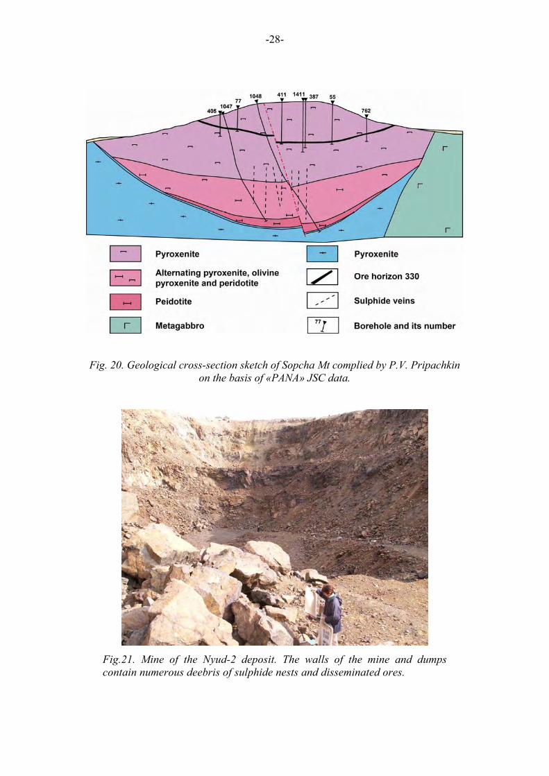
This area gives the impression of the structure of the unique element of the Monchepluton, "Horizon 330". The "Horizon 330" represents a large deposit of disseminated sulphide ore in the upper part of the Monchepluton section. The average thickness of the ore body is about 4-5 m, the diameter is about 2 km, and the total reserves of Cu, Ni, Co are about 260 thousands of tons. Historically, the exploration of "Horizon-330" in 1930s gave grounds to build the mining complex "Severonickel", but the deposit itself has not been mined because of the poor ore quality. Poor quality of the ore is accounted for by the high content of silicate nickel linked with olivine. The problem of the deposit genesis is one of the most exiting puzzles related to the Monchepluton. The deposit is confined to discontinuous flow layers of olivine-bearing rocks: olivinites, peridotites (harzburgites), olivine pyroxenites, feldspar olivine pyroxenites occurring within the pyroxenite (bronzitite) sequence in the upper part of the Mt. Sopcha section. The olivine-bearing rocks and associated sulphides are, so to say, hanging at a height of about 800 m from the pluton bottom (Fig. 7) and are bounded by bronzitites from the top and below. The sulphide-bearing rocks composing separate lens-like bodies at several levels make up a relatively pesistent "horizon", outcropping along the whole perimeter at the slopes of Mt. Sopcha at a height of 330 m (Fig. 20). The most spectacular and complete sections of the ore horizon with peridotites and all peculiar genetic fragments can be observed at the western slope of Mt. Sopcha (excursion stop). At the eastern slope the exposure of «Horizon 330» lacks peridotites, and only olivine pyroxenite and feldspar olivine pyroxenite crop out. The «Horizon 330» sulphide ore is fine-grained, and possesses high PGE concentrations in the sulphide mass in comparison with other types of the Monchepluton ores. The highest PGE concentrations are confined to the lower part of the horizon, i.e. to pegmatoid pyroxenites.
Fig. 19. Fragments of thinly layered pyroxenite and peridotite of the «Horizon 330» at Sopcha Mt.
-28-
Fig. 20. Geological cross-section sketch of Sopcha Mt complied by P.V. Pripachkin on the basis of «PANA» JSC data.
Fig.21. Mine of the Nyud-2 deposit. The walls of the mine and dumps contain numerous deebris of sulphide nests and disseminated ores.
-29-
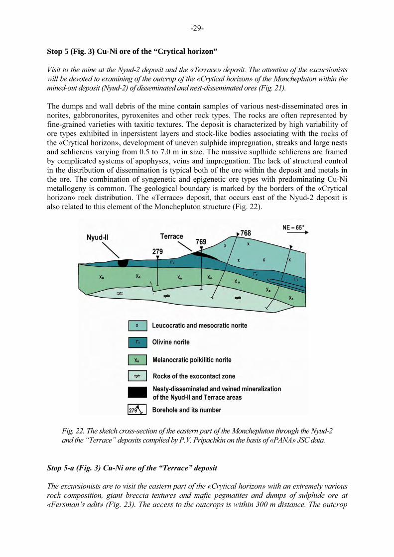
Stop 5 (Fig. 3) Cu-Ni ore of the “Crytical horizon” Visit to the mine at the Nyud-2 deposit and the «Terrace» deposit. The attention of the excursionists will be devoted to examining of the outcrop of the «Crytical horizon» of the Monchepluton within the mined-out deposit (Nyud-2) of disseminated and nest-disseminated ores (Fig. 21). The dumps and wall debris of the mine contain samples of various nest-disseminated ores in norites, gabbronorites, pyroxenites and other rock types. The rocks are often represented by fine-grained varieties with taxitic textures. The deposit is characterized by high variability of ore types exhibited in inpersistent layers and stock-like bodies associating with the rocks of the «Crytical horizon», development of uneven sulphide impregnation, streaks and large nests and schlierens varying from 0.5 to 7.0 m in size. The massive suplhide schlierens are framed by complicated systems of apophyses, veins and impregnation. The lack of structural control in the distribution of dissemination is typical both of the ore within the deposit and metals in the ore. The combination of syngenetic and epigenetic ore types with predominating Cu-Ni metallogeny is common. The geological boundary is marked by the borders of the «Crytical horizon» rock distribution. The «Terrace» deposit, that occurs east of the Nyud-2 deposit is also related to this element of the Monchepluton structure (Fig. 22).
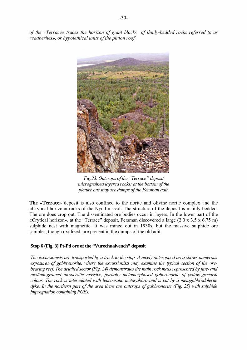
Stop 5-а (Fig. 3) Cu-Ni ore of the “Terrace” deposit The excursionists are to visit the eastern part of the «Crytical horizon» with an extremely various rock composition, giant breccia textures and mafic pegmatites and dumps of sulphide ore at «Fersman’s adit» (Fig. 23). The access to the outcrops is within 300 m distance. The outcrop
Fig. 22. The sketch cross-section of the eastern part of the Monchepluton through the Nyud-2 and the “Terrace” deposits complied by P.V. Pripachkin on the basis of «PANA» JSC data.
-30-
of the «Terrace» traces the horizon of giant blocks of thinly-bedded rocks referred to as «sadberites», or hypotethical units of the pluton roof.
The «Terrace» deposit is also confined to the norite and olivine norite complex and the «Crytical horizon» rocks of the Nyud massif. The structure of the deposit is mainly bedded. The ore does crop out. The disseminated ore bodies occur in layers. In the lower part of the «Crytical horizon», at the “Terrace” deposit, Fersman discovered a large (2.0 х 3.5 х 6.75 m) sulphide nest with magnetite. It was mined out in 1930s, but the massive sulphide ore samples, though oxidized, are present in the dumps of the old adit.
Stop 6 (Fig. 3) Pt-Pd ore of the “Vurechuaivench” deposit The excursionists are transported by a truck to the stop. A nicely outcropped area shows numerous exposures of gabbronorite, where the excursionists may examine the typical section of the ore-bearing reef. The detailed sector (Fig. 24) demonstrates the main rock mass represented by fine- and medium-grained mesocratic massive, partially metamorphosed gabbronorite of yellow-greenish colour. The rock is intercalated with leucocratic metagabbro and is cut by a metagabbrodolerite dyke. In the northern part of the area there are outcrops of gabbronorite (Fig. 25) with sulphide impregnation containing PGEs.
Fig.23. Outcrops of the “Terrace” deposit micrograined layered rocks; at the bottom of the picture one may see dumps of the Fersman adit.
-31-
Fig. 24. The geological sketch map of the Vurechuaivench layered horizon (by P.V. Pripachkin, T.V. Rundkvist on the basis of «PANA» JSC data).
1- mesocratic metagabbronorite; 2- leucocratic metagabbro and anorthosite; 3- metagabbrodolerite dike; 4- layering strike and dip; 5- geological boundaries; 6- tectonic dislocations; 7- autochthonous outcrop and alluvial fragment contours; 8- levels of sulphide mineralization; 9- Typical locations for examining
-32-
The «Vurechuaivench» prospect is confined to the zone of alternating meso-leucocratic massive and taxitic gabbronorite and anorthosite-plagioclasite. The PGE mineralization is related to the extensive zone of lens-like and tabular sulphide bodies. The mineralized zone is conformable to the layering, and contains about 20 sulphide horizons.
The horizons are marked by a 1-3-m thick interval of rich ore, resemling a reef in a way. The length of the rhythmically layered series is 7-8 km along strike, the width is 1.5 km, and the thickness is up to 1 km. The content of ore minerals reaches 5-10%. The ore minerals are chalcopyrite, pyrrhotite, millerite, and Ni and Co arsenides. The PGE minerals are represented by Pd and Pt telluro-bismuthides, sulphides, arsenides and sulphoarsenides. Among them are kotulskite, merenskite, maichenerite, moncheite, sperrhylite, mayakite, arsenopalladinite, mertiite, stibiopalladinite, stillwaterite, and gold and silver minerals, intermetallic phase of silver and gold and hessite with predominant Pt and Pd tellurides (55 %). The grain size varies from 10 to 70 μm. The total PGM content is 0.5-15 ppm. The Imandra lopolith Stop 1 (Fig. 4) Cr ore of Mt. Majyavr-Devich’ya prospect The excursionists may examine the structure of the gabbronorite layer and vertical chromite horizon in several outcrops (Fig. 2). The exposures of the gabbronorite are traced by a ridge for over 300 m. In the lower part, they change into the endocontact zone of the Imandra lopolith with the Imandra-Varzuga belt. The contact is well-exposed. The Devich’ya-Maryavr massif extends for 18 km north-westwards, has a shape of 2.5-m-thick vertical plate, and occurrs in amphibolite, presumably of the Archean age. The chromite prospect
Fig. 25. Autochthonous outcrops of meso-leucocratic anorthosite with the low-sulphide PGE mineralization at the Vurechuaivench deposit.
-33-
locates in the lower level of the Imandra lopolith main zone layering. It is easily accessible from the Murmansk-Saint-Petersburg highway, 10 km south of the city of Monchegorsk. The chromitite layer occurrs vertically in the gabbronorite, and has a visible thickness of 0.5m at the surface.
Stop 2 (Fig. 4) Cr ore of the Bol’shaya Varaka deposit The excursionists will visit a series of outcrops of chromitite body in the plagiopyroxenite extending for over 100 m (Fig. 27, 28). The Bol’shaya Varaka chromite deposit is situated 11 km south of the city of Apatity. The ascertained reserves of the chromite ore exceed 7 mln. tons at the average Cr2O3 content of 22.5%. The deposit is trenched and easily accessible for observing the chromite layer in the outcrop, occurring here laterally, as is opposed to the Majyavr-Devich’ya deposit. The Bol’shaya Varaka massif, occurring among the gneiss of the Archean complex, represents an erosion remainder of the Umbarechensky massif, which structure is complicated by cross-cut tectonic dislocations. The massif shows well-preserved fragments of the lower layered zone and incorporated chromitite ore, that are partially exposed at the surface (Fig. 27) and penetrated by boreholes at depth. The lower zone and chromitite in the cross-section represent a lens-like body extending eastwards. The lens is thickest in the central part of the massif. The content of cumulative orthopyroxene in the plagiopyroxenite and melanocratic norite ranges
Fig. 26. The participants of excursion visit the chromitite layer in Mt. Mayavr-Devich’ya gabbronorite.
-34-
within 60-80 %; that of intercumulative plagioclase and clinopyroxene is 10-30% and 5-10 %, respectively. The early generation of chrome-spinelid is also referred to as a cumulative phase.
The rocks and ores of the near-contact part are metamorphosed, but the relics of the primary minerals are preserved. The lower marginal zone has a thickness of 90 m at Mt. Bol’shaya Varaka, and is composed of taxitic microgabbronorite (Mitrofanov et al., 1995).
Fig. 27. Outcrops of the chromitite layer in the Bolshaya Varaka deposit trench.
Fig. 28. Outcrop of the chromitite layer; the upper boundary (dark colour) with gradual transition into the country rocks is clearly visible.
-35-
REFERENCES
Amelin Yu.V., Heaman L.M.& Semenov V.S. 1995: U – Pb geochronology of layered mafic intrusions in the eastern Baltic Shield. Precambrian Res, v. 75, 31-46. Balashov Yu.A. 1996: Geochronology of the Pechenga-Varsuga structure earlyproterozoic rocks of the Kola Peninsula. Petrology, T. 4, N 1, 3-25. (In Russian). Balashov Yu.A., Bayanova T.B. & Mitrofanov F.P. 1993: Isotope data on the age and genesis of layered basic-ultrabasic intrusions in the Kola Peninsula and Northern Karelia, northeastern Baltic Shield. Precambrian Research, v. 64, N 1-4, 197-205. Bayanova T.B. Geochronological age of reference…, 2005. Bayanova T.B., Galimzyanova R.M & Fedotov Zh.A. 2001: Evidence of the multifase complex history of the Imandra lopolith. In: Svekalapko 6th workshop, Lammi, Finland, abstracts, p. 7. Bibikova E.V. U-Pb geochronology of the early stages of the old shield evolution. –M.: Nauka, 1989. -180 p. Voche-Lambina Archean geodynamic polygon of the Kola Peninsula. Mitrofanov F.P. & POzhilenko V.I. (editors). –Apatity: publ. of KSC RAS, 1991. -196 p. Geologi of the Kola Peninsula (Baltic Shield). Mitrofanov F.P/ (Editor) Apatity, 1995, 145 p. Grokhovskaya T.L., Bakaev G.F., Shelepina E.P., Lapina M.I., Laputina I.P., Muravitskaya G.N. PGE mineralization in the gabbronorite of the Vurechuaivench massif, Monchepluton (Kola Peninsula, Russia). Geology of ore deposits, 2000, V. 42, №2, pp. 147-161. Grokhovskaya T.L., Bakaev G.F., Lapina M.I., Sholokhnev V.V. PGE mineralization of the Monchetundra. Proceedings of the All-Russian symposium «Geology, genesis and problems of developing complex deposits of noble metals» - M.:LLC «Svyaz-print», 2002, pp. 136-140. Dedeev A.V., Khashkovskaya T.N., Galkin A.S. PGE Mineralization of the Monchegorsk Layered Mafic-Ultramafic Intrusion of the Kola Peninsula. // The Geology, Geochemistry, Mineralogy and Mineral Beneficiation of Platinum-Group Elements. Edited by Louis J.Cabri. Canadian Institute of Mining, Metallurgy and Petroleum, Special Volume. 54, p. 569-577, 2002 . Dokuchaeva V.S., Zhangurov A.A. & Fedotov ZH.A. 1982: Imandra Lopolith – a new major layered intrusive on the Kola Peninsula. Doklady AN SSSR, v. 265, N 5, 1231-1234. (In Russian). Dokuchaeva V.S., Sholokhnev V.V. New data on the geological structure of the Nyud-Poaz massif. Regional geology, metallogeny and geophysics. Apatity: publ. of Kola branch of USSR Academy of Sci., 1974, pp. 88-95. Dokuchaeva V.S., Yakovlev Yu.N. 1994: Monchegorsk pluton. In: Kola Belt of layered intrusions. Apatity, 71-100. Imandra-Varzuga zone of Karelides. Zagorodny V.G., Predovsky A.A., Basalaev A.A. et al. – M : Nauka, 1982. – 280 p.
-36-
Iljina, Markku, The Portimo Layered Igneous Complex – with emphasis on diverse sulphide and platinum-group element deposits. Departament of Geology, University of Oulu, Finland. Acta Univ. Oul. A 258, 1994. Oulu, Finland. The catalogue of geochronological data on the NE Baltic Shield. Bayanova T.B., Pozhilenko V.I., Smilkin V.F. et al. Apatity: publ. of KSC RAS, 2002. – 53 p. Kozlov E.K. 1973: Natural rock series of nickel-bearing intrusions and their metallogeny. Leningrad, Nauka, 288 pp. (In Russian). Mitrofanov F.P., Balagansky V.V., Balashov Yu.A. et al. 1993: U –Pb age of gabbro-anortosites of the Kola Peninsula. Doklady AN, V. 331, N 1, 95-98. (In Russian). Mitrofanov F.P., Korchagin A.U., Dudkin K.O., Rundkvist T.V. Fedorov-Pana layered mafic intrusion (Kola peninsula, Russia): approaches, methods, and criteria for prospecting PGEs. 2005. Mineralogical Association of Canada Short Cousrse 35, Oulu, Finland, p. 343-358. Mitrofanov F.P., Neradovsky Yu.N., Subbotin V.V., Rundkvist T.V., Karpov S.M., Gabov D.V., Korchagin A.U., Pripachkin P.V. Ore-bearing rocks and species varieties of PGM minerals in intrusive complexes of the Kola region/ 10th International Platinum symposium (August 7-11), 2005, University of Oulu, Finland. Mitrofanov F.P., Yakovlev Yu.N., Balabonin N.L. et al. 1994: The Kola platinum-bearing province. Platinum of Russia. Moscow, Geoinformmark, 66-76. (In Russian) Naldrett A.J. Magmatic Sulfide Deposits of Nickel-Copper and Platinum-metal ores. – St.Petersburg: St. Peterburg university, 2003, 487 p. Neradovsky Y.N. On the problem of the formation of layered mafic intrusions: an example from the Monche Pluton, Kola region // SVEKALAPKO. An EUROPROBE project, 2nd Workshop Lammi, Finland, 27-30.11.97. Abstracts. University of Oulu, Department of Geophysics, Report No. 21. - 1997. - P. 60. Neradovsky Y.N., Borisova V.V., Sholokhnev V.V. The Monchegorsk layered complex and related mineralization. Ore deposits of the Kola Peninsula, Northwestern Russia. Research and exploration - where do they meet? 4th Biennial SGA Meeting, August 11-13, 1997. Turku, Finland. Excursion guidebook B4 Geological Survey of Finland. Gueide 45. - 1997. - P. 27-31. Nickel-Ropper Deposits of the Baltic Shield // G. I. Gorbunov, V. G. Zagorodny, V. I. Robonen, Yu. N. Yakovlev, Yu. V. Goncharov, V. F. Gorelov, V. A. Tel'nov, A. I. Kairyak, S. A. Morosov, H. Papunen, A. Vorma, G. Gaal, J. Kurki, J. Lahtinen, J. Parkkinen, J. Reino, M. Isohanni, V. Ohenoja, J. Koskinen, L. Grundstrom, T. A. Hakli, A. Stenberg, p. Sipila, P. Ervamaa, G. Nilsson, B. Lundberg, R. Boud, F. L. Nixon. - L., "Nauka", 1985. 329 p. Pavlovsky V.I., Galichanina L.D., Ivanov G.A. et al. 1976: A new data on the south-east part Monchegorsk ore region composition. In: Geophisical researchs in the north-eastern region of the Baltic Shield, Apatity, 36-44. (In Russian). Layered intrusions of the Monchegorsk ore field: petrology, isotopy, mineralization, and deep structure. Authors: Smolkin V.F., Fedotov Zh.,A, Neradovsky Yu.N., Bayanova T.B., Borisova
-37-
V.V., Glaznev V.N., Dedyukhin A.N., Orsoev D.A., Ohnenstetter D., Raevsky A.B., Tolstikhin I.N., Chaschin V.V., Mokrushin A.V., Novikov D.D., Ikorsky S.V., Kamensky I.L., Delenitsyn A.A., Mitrofanov F.P. Ed. by Smolkin V.F. Apatity: publ. of KSC RAS, 2003. 33 p.s. Seismologic model of the Northern Europe lithosphere: Barentsregion, P. I// Sharov N.V. (resp. ed.). – Apatity: publ. of KSC RAS, 1998. -237 p. Smolkin V.F., Bayanova T.B., Mitrofanov F.P. et al. 2001: Paleoproterozoic mantle plume magmatism (2.5 Ga), Kola Region. In: XVI Symphosium on the isotope geochemy abstracts, Moskow. Semikhatov M.A., Shurkin K.A., Aksyenov E.M. et al. 1991: A new stratigraphic time-scale of the precambrian of the USSR. Izv. AN SSSR, ser.geol., N 4, 3-14. (In Russian). Zagorodny V.G.& Radchenko A.T. 1988: Tectonics of the Karelides of the northeastern Baltic Shield. Leningrad, 111 pp. (In Russian). Chaschin V.V., Galkin A.S., Ozeryansky V.V., Dedyukhin A.N. The Sopcheozero chromite deposit and its PGE content. Monchepluton (Kola Peninsula, Russia) //. – Geology of ore deposits, 1999, V. 41, № 6, pp. 507-515. Sharkov E.V., Bogatikov O.A. Concentration mechanisms of platinum – group elements in layered intrusions of the Kola-Karelia region: Geology of ore Deposits, 1998, v.40. p.372-390. Yakovlev Yu.N., Dokuchaeva V.C. PGE mineralization of the Monchepluton. Geology and genesis of PGM deposits. M.: Nauka, 1994, pp. 79-86.