1 Department of Geography, University of Montenegro, Niksic, Montenegro; [email protected] 6 2 Department of Geography, University of Montenegro, Niksic, Montenegro; [email protected] 7 3 University of Novi Sad, Faculty of Technical Sciences, Serbia; [email protected] 8 4 University of Novi Sad, Faculty of Technical Sciences, Serbia; [email protected] 9 5 University Donja Gorica, 81000 Podgorica, Montenegro; [email protected] 10 6 Faculty of Technical Sciences in Kosovska Mitrovica, University of Prishtina; [email protected] 11 7 Faculty of Civil Engineering, Podgorica, University of Montenegro; [email protected] 12 8 Economics&Engineering Management, University Business Academy, Novi Sad, Serbia; 13
Abstract: This paper deals with an analysis of cartographical studies, the real estate cadastre, and 17 its practical implementation, as well as the introduction of cartography into different education 18 modules in university-level studies in Montenegro. There is a discussion of the development, 19 production, and creativity in the fields of cartography and real estate cadastre over time, 20 cartographical projection, scientific results, and recent changes such as advanced computer- and 21 satellite-based technologies, GIS, cartographical visualization, and digital cartography. The impact 22 of these changes on cartographical studies at the University of Montenegro is considered. 23 Particular attention is given to analyses of cartography and the cadastre in institutions, and their 24 connection with the development of cartography teaching modules of Geography, Geodesy and 25 Geoinformatics at the University of Montenegro. The integrated analysis also covers the results of 26 the questionnaire and the significance of the geo-topographical and cartographical heritage of 27 Montenegro, with the aim of carrying these out. It can be seen that the tasks solved by using maps 28 have tended to become more complex and that the cartographical methods employed in this have 29 been always directed towards Montenegro’s most prominent and most urgent problems, including 30 those that appear in the area of education. 31
1. Introduction 35 The existing challenges of a practically already-formed third-millennium civilization have an 36
essential geographical dimension. The position of the scientific and technical public – that, from 37 being an industrial society, we have reached the phase of a so-called ‘society of risk’ – is more than 38 justified. Such a society is characterized by, in addition to permanent progress and conflicts, a strong 39 need for detailed GIS databases, especially for a geo-ecosphere, which is subject to a high degree of 40 anthropopression (climate change and a degraded environment), followed by an inevitable increase 41 in the number and severity of natural catastrophes. 42
Cartography, in collaboration with other geospatial sciences, has always dealt with various 43 tasks concerning the detecting, collection, processing and presenting of actual data and information 44 about geospace. 45
Preprints (www.preprints.org) | NOT PEER-REVIEWED | Posted: 26 June 2018 doi:10.20944/preprints201806.0414.v1
Maps are intertwined with mankind’s existence; they are “time in motion”, a witness of change, 46 and a spontaneous means of communication, an essential attribute of the development and progress 47 of civilization. In the historical development of cartography, cartography also reflects on its own 48 temporal development, often directed to the cartographical heritage of the particular geospace. With 49 this understanding, the explorative character of our research was defined. 50
Through the many layers of analysis of Montenegro’s geo-topographical and cartographical 51 heritage, we have covered several domains in our approach: the territorial reach, the contents and 52 the thematic and temporal framework. A refocusing has been carried out, not only in relation to 53 geographical investigation of the geospace of Montenegro, but also in relation to the way geodata 54 are gathered, the quality and the cartographical methods applied, the purpose of the map, and the 55 personnel or institutions that commissioned or published the map. A qualitative basis is formed, 56 within which the categorization of maps, their chronology, and the separate primary cartographical 57 sources is carried out, which in the continued process enables a more advanced level of analysis of 58 the geo-topographical and cartographical heritage of Montenegro. 59
2. Materials and Methods 60
Modern cartography in Montenegro is not only a ‘specialist’ science and/or method, which 61 observes space from the perspective of its own narrow domain – that is, from the perspective of its 62 relation to the subject – but is also a science present in all spheres of the functioning and institutional 63 organization of Montenegrin society. 64
In the research procedure, cartographical activity in Montenegro is presented here using 65 historical and cartographical methods of analysis, taking into account the authors, the importance, 66 the content and time of production of each cartographical work. Documents that vary in rank and 67 origin are analyzed methodologically in the framework of the existing historical, geographical and 68 cartographical literature, the documentation of their systemic representation. 69
The data mentioned in the analyses is mostly cited from the following sources: Sindik, I. 1931, 70 1932, Šobić, D. 1953, Senđerđi, J. 1955, Škrivanić, G. 1974, 1979, Cartography (Military Institute of 71 Geography, Belgrade – Chapters 14 and 15) 1974, Hassert, K. 1995, Radusinović, P. 1996, Il 72 Montenegro, Da relazioni dei provveditori veneti (1687-1735) 1998, Dvorski, V. 2000, Pulević, V. 73 2006, Radojičić, B. 2008 and Nikolic, G. 2010. 74
The most important works that have been historically essential to the development of 75 cartography in Montenegro, due to their cartographical and graphical representation and formation, 76 are cited. A review of the cartography of modern geoscience and specialist practice is also presented, 77 especially concerning geo-ecological mapping and its visual cartographical language, as a parallel 78 language of the sciences and disciplines of geography, geology, ecology and geotechnics. These 79 documents are presented separately at the end of the text in the form of a table (Table 1). 80
The research was also supported by a questionnaire, within which two groups of questions are 81 defined. Those results are presented at the Questionnaire section of the Results and Discussion 82 chapter. 83
3. Results and Discussion 84 3.1. Historical Development, Scientific Results and Cartographical Production in Montenegro 85
Considered retrospectively, the Montenegrin national geospace has experienced not only 86 territorial fragmentation, but also intensive cultural, historical, and civilizational influence: from 87 ancient times until the present day. 88
Montenegro, as an independent state on the Balkan Peninsula, had neither local cartographers 89 nor an official state cartographical institution. The first sufficiently clear forms of Montenegrin 90 cartography within the framework of the Balkans can be followed from the second half of the 18th 91 century (Senđerđi, 1955). 92
Crtographical activity connected with the territory of Montenegro is conditionally divided into 93 two parts, in which: 94
Preprints (www.preprints.org) | NOT PEER-REVIEWED | Posted: 26 June 2018 doi:10.20944/preprints201806.0414.v1
- Montenegro was mapped and graphically presented, together with the neighboring regions and 95 countries; and 96 - Montenegro was cartographically presented as a separate geographical and political entity. 97
The area of present-day Montenegro appeared very early on in geographical and historical 98 maps. This relates to a territory which was intrinsically in the contact zone between the ancient 99 civilizations of Greece and Rome (Peterca et al., 1974). This contributed to the earliest preserved 100 ancient maps which include those territories that constitute present-day Montenegro. The elements 101 concerning the physical geographical contents of this territory mostly appear as contours, and 102 resemble a rough sketch. Two primary cartographical sources that were characteristic of this period 103 were analyzed. 104
Ptolemy’s geographical handbook Γεωγραφικὴ Ὑφήγησις (Geography), according to both the 105 text and cartography, especially in the presentation of Europe (maps 5 and 9) (Škrivanić, 1974), in the 106 8th book of this work, shows graphically the physical-geographical territory of present-day 107 Montenegro with sufficient fidelity (coasts, islands, rivers, mountains and settlements). 108
Tabula Peutingeriana, dated to the 3rd century A.D., as a cartographic work , belongs to the 109 Roman period (Sindik, 1931). This map is characterized as having been produced for the purposes of 110 physical geography by its representations of roads and important settlements – particularly of the 111 coastal and central parts of Montenegro. 112
Major geographical discoveries in the late 15th and early 16th centuries were followed by the 113 intense development of cartography in Italy and Venice. The present-day territory of Montenegro 114 was presented in various original manuscripts and maps, and also on maps within the framework of 115 various thematic atlases (Škrivanić, 1979). We have dealt with one map and three thematic atlases 116 with a subject-based analysis. 117
On the map Europae Descriptio Anno 1500, Montenegro, with Cetinje shown, was represented 118 as one of the 28 countries in Europe at that time. This map is a primary source. According to 119 historical data, this was, apart from Dubrovnik and some parts of Dalmatia, the only free part of the 120 territory of South-East Europe at that time (Sindik, 1932). 121
The atlases, made by the well-known cartographical workshop of V.M. Coronelli (1650–1718), 122 contain cartographical representations of parts of the territory or of the whole modern-day territory 123 of Montenegro (Sindik, 1932). The collection of the museum of the old naval town of Perast (with 124 more than 2,000 items) contains a copy of an atlas from Coronelli’s Map of Montenegro – 125 Geographicus; together, the collection forms an invaluable treasure of Perast and offers a probable 126 picture of the way of life for the town and the Bay of Kotor over the previous centuries. 127
In an atlas made by the well-known Dutch cartographer A. Ortelius (1570), Theatrum Orbis 128 Terrarum, the territory belonging to present-day Montenegro is represented on three maps, at 129 different scales. 130
One of the best-known European cartographical workshops of that time, that of G. K. Mercator, 131 produced Atlas sive cosmographiae meditationes de fabrica mundi et fabricati figura, where the 132 territory of Montenegro is contained in the second volume, within the framework of four 133 cartographical and graphical presentations, and it is a similar story for many other contributions in 134 the atlases and maps of European publishers of that time. 135
The complicated geopolitical situation of the region to which modern-day Montenegro belongs 136 was particularly expressed from the mid-18th century and throughout the 19th century, beginning 137 from the three-way confrontation between the Venetian Republic, the Habsburg Monarchy, and the 138 Ottoman Empire, until the wars of liberation and the creation of the Montenegrin state. This was also 139 the time when the first topographic measurements in the Habsburg lands were being made. Vienna 140 became the most important cartographical center where, already from the 16th century, data and 141 cartographical contributions concerning the lands of the Southern Slavs were being collected and 142 published, including those of the present-day territory of Montenegro. The cartographical heritage 143 of this time horizon is represented in many geographical, topographical, and historical maps (Il 144 Montenegro, da relazioni dei provveditori veneti 1687–1735, (1998)), which belong to the Ottoman, 145 Austro-Hungarian, French, Russian, and English schools of cartography. 146
Preprints (www.preprints.org) | NOT PEER-REVIEWED | Posted: 26 June 2018 doi:10.20944/preprints201806.0414.v1
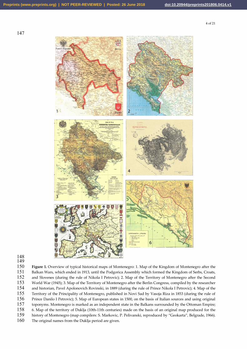
148 149 Figure 1. Overview of typical historical maps of Montenegro: 1. Map of the Kingdom of Montenegro after the 150 Balkan Wars, which ended in 1913, until the Podgorica Assembly which formed the Kingdom of Serbs, Croats, 151 and Slovenes (during the rule of Nikola I Petrovic); 2. Map of the Territory of Montenegro after the Second 152 World War (1945); 3. Map of the Territory of Montenegro after the Berlin Congress, compiled by the researcher 153 and historian, Pavel Apolonovich Rovinski, in 1889 (during the rule of Prince Nikola I Petrovic); 4. Map of the 154 Territory of the Principality of Montenegro, published in Novi Sad by Vasoja Riza in 1853 (during the rule of 155 Prince Danilo I Petrovic); 5. Map of European states in 1500, on the basis of Italian sources and using original 156 toponyms. Montenegro is marked as an independent state in the Balkans surrounded by the Ottoman Empire; 157 6. Map of the territory of Duklja (10th-11th centuries) made on the basis of an original map produced for the 158 history of Montenegro (map compilers: S. Markovic, P. Pelivanski, reproduced by “Geokarta”, Belgrade, 1966). 159 The original names from the Duklja period are given. 160
Preprints (www.preprints.org) | NOT PEER-REVIEWED | Posted: 26 June 2018 doi:10.20944/preprints201806.0414.v1
Among them, we have singled out those maps which belong to the category of primary 161 cartographical sources. 162
The map The Ottoman Empire was produced by La Rouge; it was published in Paris in 1770. 163 The territory of Montenegro was given on sheet No. 10, where one can find Montenegro and the Bay 164 of Kotor as an additional map. 165
The map Zemljo-obražanije Serpske, Bosne, Dalmacije i Crne Gore, published in Vienna in 1805, 166 was produced by S. Popović Tekelija. This map presents the territory of Montenegro separately. 167
A French colonel, L.C. Vialla de Sommières, produced a map with a scale of 1:260,000 on the 168 basis of his ‘own notes when he stayed in Cetinje and travelled around Montenegro in 1809’. The 169 map was given as a supplement in the book Voyage historique et politique au Monténégro (A 170 Historical and Political Voyage to Montenegro), which de Sommières published in Paris in 1820. 171
The map of Count F. de Karacsaya (1829), Carte du pays de Monténégro (Map of the Country of 172 Montenegro), was made with a scale of 1:288,000; this is a primary cartographical source. According 173 to K. Hassert, it was a ‘decisive step forward and a real scientific victory’. K. Hassert also cites as an 174 important cartographical work the Map of Montenegro (Herbert, 1836), whose author is Nikola 175 Milošev from Vasojevici (Hassert, 1995). 176
In 1841 in St. Petersburg, the Russian officer and diplomat, J. Kovalevski, published, in addition 177 to his work Four Months in Montenegro, a map of the Montenegro of that time (Senđerđi, 1955). 178
The Montenegrin Prince Danilo in 1853 asked the Austrian officer, Vuković, to draw up a map 179 of Montenegro. This map was never officially published, but two copies of it (scale 1:280,000) are 180 kept in the Military Institute of Geography in Vienna; according to K. Hassert ‘it is an important 181 development in Montenegrin cartography’ (Hassert, 1995). 182
In Southampton, the British lieutenant, Sittwel, produced Sittwel’s Map of Montenegro with a 183 scale of 1:200,000, which was published in London in 1860. A similar contribution is Carta di 184 Montenegro, an Austrian map made by I. Paulini with a scale of 1:300,000. It was published in 185 Vienna in 1861. 186 The Military Institute of Geography in Vienna in 1869 published the map, Das Fürstentum Zrnagora 187 oder Montenegrou, with a scale of 1:144,000, which was drawn up on the basis of geodetic 188 measurements performed when it bordered Turkey (Dvorski, 2000). This institute produced 189 Generalkarte von Bosnien, der Hercegovina, von Serbian und Montenegro, with a scale of 1:300,000, 190 which was published in 1876. This map used as its mathematical basis astronomical points 191 determined in the framework of a campaign led by Šternik during 1872/73, together with Captain 192 Milinković; framing data published during 1867/68 was used for the coastal belt and maritime 193 region. 194
Thematically, during the whole 19th century, a whole series of various geographical and 195 topographical representations appeared, which were contributed to by scientists and the authors of 196 travelogues A. Boué (1840), B. Schwarz (1883), E. Tietze (1884), A. Baldacci (1886), and K. Hassert 197 (1895), who were interested in the territory of Montenegro, and researched and mapped it. This was 198 of particular interest to geologists, geographers, and botanists. Most of these cartographical 199 contributions are now found in European archives – Table 1 (in Vienna, Prague, Rome, Venice, St. 200 Petersburg, Berlin, and Belgrade). 201
Two works should be distinguished: one by Pavle A. Rovinski, Vojno topografski odjel 202 gla¬v¬nog generalštaba (Military Topographical Department of the General Staff), St. Petersburg, 203 1889, and the second, Karta knjažestva Černogorskogo (Map of the Principality of Montenegro), 204 with a scale of 1:294,000 (topographical framing with a magnification of 7, scale 1:42,000) 205 (Radusinović, 1995). 206
P.A. Rovinski’s map is a cornerstone for this period of the development of cartography in 207 Montenegro. The analysis of this map shows ‘topographical gaps – a term of J. Senđerđi’, and an 208 inconsistency in the contents and deviation from the actual appearance of the terrain (errors in 209 interpreting the content on Austrian maps of that time), but P.A. Rovinski’s map is the first work 210 which was performed with a mathematical and geodetic basis – the triangulation of the entire 211 territory of the Montenegro of that time (Senđerđi, 1955). This map represents one of the most 212
Preprints (www.preprints.org) | NOT PEER-REVIEWED | Posted: 26 June 2018 doi:10.20944/preprints201806.0414.v1
important sources for analyzing the cartographical heritage of Montenegro (especially for 213 19th-century cartography). 214
The topographical basis for this map is contributed to by measurements with a scale of 215 1:168,000, which were performed from 1860 to 1866, with additions from 1874 to 1876. These 216 measurements were performed by the Russian officer, P. Bikov. An important element of this map is 217 topographical measuring and triangulation carried out between 1879 and 1881, which was 218 performed during the establishing of the ‘Montenegrin borders’ following the terms of the Treaty of 219 Berlin, as well as the additional surveying carried out by P.A. Rovinski in 1889. 220
In the late 19th century, the most important cartographical institution, the Military Institute of 221 Geography in Vienna, produced several cartographical contributions for the territory of Montenegro 222 (special topographical maps) Spezialkarte des Fürstentums Montenegro, at scales of 1:50,000, 223 1:75,000 and 1:100,000. At the very beginning of the 20th century this institute also produced 224 Generalkarte Montenegro, at a scale of 1:200,000 (Senđerđi, 1955). 225
The first serious research studies and books about Montenegro were completed in parallel with 226 this – especially studies into physical geography and geology, the content of which was 227 accompanied by important cartographical contributions from K. Hassert (1895), P.A. Rovinski 228 (1888–1915), and J. Cvijić (1899–1921) (Pulević, 2006). 229
The third epoch relates to the period from 1945 to 1992, and covers the period of the existence of 230 the Socialist Federal Republic of Yugoslavia (SFRY) and this was a developmental phase for modern 231 cartography in Montenegro. This period includes a large number of very high-quality cartographical 232 productions in the field of topographical, thematic and atlas-type cartography, and are products of 233 the Yugoslav school of cartography. 234
The most important work is certainly the realization of Osnovna topografska karta SFRJ (Basic 235 Topographical Map of SFRY) with a scale of 1:25,000 (in two editions 1951–68 and 1969–80, two 236 variants), as the main cartographical source for the composition of a whole series of topographical 237 maps, as well as of other general geographical and thematic maps. This is a primary cartographical 238 source, with very detailed and precise cartography of the geospace of Montenegro, shown on 142 239 topographical sheets. General maps of the Adriatic Sea were also made with scales of 1:100,000 and 240 1:180,000. 241
During this period a large number of maps were made in which Montenegro was shown as a 242 separate territorial unit (republic), as well as being part of the SFRY. 243
The Republican Geological Survey of Montenegro in Podgorica published Geološka karta Crne 244 Gore (Geological Map of Montenegro) at scales of 1:100,000 and 1:200,000, which was also followed 245 by a geological interpreter. The Montenegrin Institute of Agriculture (G. Đuretić, B. Fuštić) produced 246 Pedološka karta Crne Gore (Pedological Map of Montenegro), at a scale of 1:50,000. These are very 247 significant thematic maps. 248
A thematic map, Geomorfološka karta Jugoslavije (Geomorphological Map of Yugoslavia), part 249 of which covers the territory of Montenegro, has a scale of 1:500,000 (B. Radojičić, M. Burić, M. 250 Mirković); it was published by the ‘Jovan Cvijić’ SANU Institute in Belgrade in 1990 (Radojičić, 251 2006). 252
A fact deserving attention is that activities were carried out at the Institute of Geography in 253 Nikšić, through which the initial research and methodology for the thematic national Atlas of 254 Montenegro were realized (G. Nikolic, 1999; 2010). 255
The Istorijsko-geografski atlas Crne Gore (Historical and Geographical Atlas of Montenegro) by 256 academician J. Milović was published in 1990. The atlas contains more than 200 historical and 257 geographical maps, gravures, drawings, and sketches of Montenegro collected and ordered 258 chronologically and territorially; it shows how the modern Montenegro was formed, as well as how 259 its cartography developed (Milovic, 1990). This atlas has great practical significance and is the most 260 important work for a retrospective of the historical development of Montenegro’s cartography. 261
The thematic Atlas biodiverziteta Crne Gore (Atlas of Montenegro’s Biodiversity), (2002), is an 262 original work by academicians V. Pulević, V. Bušković and G. Nikolić. The compilation of this atlas 263 was assisted by USAID-IRD and the Ministry for Environmental Protection of Montenegro. In a 264
Preprints (www.preprints.org) | NOT PEER-REVIEWED | Posted: 26 June 2018 doi:10.20944/preprints201806.0414.v1
similar way this team also produced Tematski atlas zaštićenog prirodnog predjela Trebjesa 265 (Thematic Atlas of the Protected Natural Landscape of Trebjesa) (2004), for the requirements of the 266 Environmental Protection Service of the Municipality of Nikšić. This is the first collection of maps 267 (on CD) which deal with the problem of protection of natural landscapes in the form of a GIS atlas. 268
Geografsko istorijski atlas (Geographical Historical Atlas) (2003) by academician M. Burić, with 269 the technical assistance of G. Barović, offers an overview of the development concerning the 270 Montenegrin state from its origin (6th and 7th centuries) up until the most recent times (Barovic, 271 2015). 272
Two more important thematic atlases appeared, whose editors were the academician M. Burić 273 and the Academy of Science and Arts of Montenegro (CANU): Atlas voda Crne Gore (Atlas of the 274 Waters of Montenegro) (2010) and Pedološki atlas Crne Gore (Pedological Atlas of Montenegro) 275 (2014). 276
The Nacionalni atlas Crne Gore (National Atlas of Montenegro) (D. Šehić, ed. G. Nikolić), 277 published in 2005, was the first attempt to undertake activities concerning a national project of such 278 importance. Nevertheless, it is necessary to point out that Montenegro lacked its most important 279 cartographical work – a National Atlas of Montenegro (Nikolić, 2010). 280
By proclaiming Montenegro an ecological state (on 21 September 1991) the conditions were 281 created for the publishing of a large number of cartographical works over the following two 282 decades. These works are of fundamental importance to thematic mapping, especially in the fields of 283 geoecology and the environment. 284
Durmitor National Park – the Map of Environment Protection (1:50,000) and Map of special 285 preserves on the park’s territory, of the existing state, the purpose of areas, the plan of usage, areas 286 and spatial organization, the protection plan and regime of spatial usage and the plan of traffic and 287 technological infrastructure (1:25,000); 288
Biogradska Gora National Park – Current state; purpose of areas, projection; purpose of areas, 289 zoning plan, protection regime and technological infrastructure, map of the valorization and 290 categorization of natural elements of the park and the wider zone, vegetation map, survey map of 291 forest function (1:25,000); 292
Lake Skadar National Park – Environmental protection map (1:25,000); 293 Lovćen National Park – Environmental protection map, potential vegetation map (1:25,000) and 294
Locality capture plan (1:5,000). 295 In the framework of the activity of the National Commission for Solving Problems Concerning 296
Environment Quality in the Zeta Plain and the Influence of the Aluminum Plant, a set of about 20 297 maps was made, concerning the water-system structures, examined according to different 298 parameters (G. Nikolić, 1992–4), with the corresponding reionization (pH, PSBs (Piralen), mineral 299 oils, phenols, fluorides, PAHs, etc.). The scale of the maps is 1:25,000. 300
The state institutions which deal with producing spatial planning documentation, through 301 Sector Study Analysis and Expertise (SS-AA), made sets of cartographical representations and 302 graphical appendices relating to the existing state, the changes and planned interventions in 303 Montenegro’s geospace. 304
One of the most important documents, and a primary cartographical source is the first spatial 305 plan of the Republic of Montenegro, which was adopted in 1986; it was amended twice (in 1991 and 306 1997). The spatial plan was followed by the Map of Graphical Contributions with thematic sets of 307 maps that had a scale of 1:420,000 (Spatial Plan of the Republic of Montenegro, 1984). 308
The data of concern to The Yugoslav Symposium оn Spatial and Urban Planning in Seismic 309 Conditions (1982) were of no lesser importance, in particular because they dealt with the 310 methodological problems in producing seismic maps for the territory of Montenegro. In addition to 311 the Maps of Earthquake Epicenters over various time periods, of particular importance are the Maps 312 of Seismic Risk, Maps of the Thickness of the Earth’s Crust on the Territory of the Socialist Republic 313 of Montenegro, and the Seismo-Tectonic Map of the Socialist Republic of Montenegro. The scale of 314 these contributions is 1:500,000. 315
Preprints (www.preprints.org) | NOT PEER-REVIEWED | Posted: 26 June 2018 doi:10.20944/preprints201806.0414.v1
After 21 May 2006 and the decision by Montenegrin citizens to live in an independent state, the 316 two most essential acts were adopted: the new Constitution (2007); and the Spatial Plan of 317 Montenegro to2020, adopted in March 2008. 318
The Spatial Plan of Montenegro, in the form of the Map of Contributions, contains about 30 319 cartographical and graphical contributions, on which its content is thematically represented. Of 320 these, 15 maps belong to the category of general cartographical contributions, having scales of 321 1:900,000 and 1:1,000,000. These contributions in the geo-ecological analysis may serve as input 322 information only. The cartographical contributions with scales of 1:200,000 and 1:100,000, on which 323 the existing and planned states of the spatial development of Montenegro are presented, together 324 with contributions for the purpose of basic studies, are the GIS baseline and the basic cartographical 325 sources and baselines used in the geo-ecological studies and analyses (Spatial Plan of Montenegro to 326 2020, (2008)). 327
On the basis of the Law on Spatial Planning (Official Gazette of Montenegro 51/08), a Rulebook 328 on the detailed contents and format of planning documents, as well as on the criteria for land use, 329 elements of urban regulation, and standardized graphical symbols was adopted. The rulebook 330 contains a textual section with 131 articles defining 11 thematic areas with 357 graphical symbols. 331
Within the framework of international and specialist projects and expert studies, geospatial 332 databases were specially produced with sets of important thematic maps and a 333 topographical/cadastral basis. This is also a reason why we covered these in this analysis. 334
There were no direct war operations on Montenegrin territory during the breakup of the former 335 Yugoslavia. However, along the separation zones (the western and north-western borders with the 336 Republic of Croatia, the north-eastern and eastern borders with Kosovo and Metohija and with 337 Albania), as well as in the NATO Corridor Zone from 1999, and also where there remained 338 unexploded lethal ordnance from the previous wars (the territorial waters of the Bay of Kotor), there 339 was a need for systematic surveying of areas where mines had been laid in Montenegro and in the 340 use of remote-detection methods and GIS in this area. 341
In order to set up the project, analog and digital baselines were used (with rasters specially 342 made for the areas included in projects), where the range of scales were from 1:5,000 to 1:1,000,000. 343 The topographical maps used have scales of 1:200,000, 1:100,000 and 1:50,000, geo-referenced in the 344 UTM coordinates system (Nikolić, 2010). 345
The ITF (International Trust Fund) of Slovenia and the JRC (Joint Research Center) donated 346 Landsat satellite frames for the areas of the former Yugoslavia (1:100,000), which have been mostly 347 used as a good basis for making and modernizing topographical maps. 348
Thanks to the results of such activities, the contaminated areas on the land part of the 349 Montenegrin territory have been very successfully cleaned up (the area with suspected mines 350 covered about 300,000 m2); the same activities also took place in coastal areas, around the Prevlaka 351 Peninsula (an area of about 500,000 m2, depth 50 m), Mamula Island, and Verige Strait. 352
The project CORINE Land Cover for Montenegro was realized during the period 2005–6 as part 353 of the Project CLC2000 for Serbia and Montenegro. The collected data was presented on maps with a 354 scale of 1:100,000, with the corresponding database for three time epochs – 1990, 2000, and 2006. 355
The Montenegrin Academy of Sciences and Arts (MASA) and Academy of Sciences of Albania 356 carried out a joint project named Regulation of the Waters of Lake Skadar and the River Bojana. The 357 framing of Lake Skadar was performed by each party on its own territory following a joint project 358 prepared by the Institute of Hydrometeorology and Seismology of Montenegro. The main project 359 task was to make a digital model of the Lake Skadar bed and of the shores within the littoral belt. For 360 that purpose, bathymetric measurements of the lake’s aquatory and aerial photogrammetric survey 361 of the shores were carried out in the period 2007–9. 362
On the basis of the obtained model, 29 map sheets were produced, in which the maps are 363 shown as an atlas; the scale is 1:10,000, the total area of the lake region and littoral belt is 402.5 km2 . 364
In 2008, the Real Estate Authority of Montenegro made the first Digital Map of Montenegro, 365 with a scale of 1:260,000. This map was updated in 2009, as its second edition, and on the reverse side 366 of the map there is a series of photographs with motifs of Montenegro. 367
Preprints (www.preprints.org) | NOT PEER-REVIEWED | Posted: 26 June 2018 doi:10.20944/preprints201806.0414.v1
Thanks to a donation from the Japanese Government in 2007, it was possible to start 368 constructing the Digital Topographic Map with a Scale of 1:25,000. In 2015 the activities on this 369 project were completed, and the marking of maps with symbols, as well as the production of the 370 infrastructural spatial data of the topographical and cartographical baseline according to the existing 371 data model, were finished. 372
Under the auspices of EuroGeographics (of which Montenegro is a member), and in 373 cooperation with the member countries of the European National Mapping and Cadastral Agencies 374 (NMCA), the Real Estate Agency is working on improving the datasets for: EuroBoundaryMap 375 (administrative and statistical units, with a scale of 1:100,000), EuroGlobalMap (a topographical 376 dataset with a scale of 1:1,000,000), EuroRegionalMap (a topographical dataset with a scale of 377 1:250,000) and other thematic maps. 378 379 3.2. Real Estate Cadastre and its Maintenance on the Territory of Montenegro 380
Valuable historical data from the Skadar Cadastre, the land register of Tuzi from 1330, the 381 cadastres of Ulcinj and Bar from 1416–7, Kotor’s cadastre from 1430 and the cadastre of Donji Grbalj 382 and Gornji Grbalj from 1439, provide evidence that the establishment of a land register in 383 Montenegro began almost 700 years ago. The land cadastre for Gornja Zeta, the territory covering 384 central and northern parts of present-day Montenegro, was mentioned in the documents of that 385 time, and can be found in various charters and the Ottoman cadastral lists known as defters. 386
The territory now belonging to Montenegro, but which was under Austrian rule in the 19th 387 century, was included as early as 1816 in the preparation for surveying and the formation of a land 388 cadastre. For this purpose a framework triangulation was carried out and a grid of points was 389 formed with a density not exceeding three points per square mile (this corresponds to linear lengths 390 of about 5 km between points). The grid of trigonometric points contained points of orders I, II, III 391 and IV (graphical triangulation). 392
The detailed measurement of territorial units, some of which were referred to as tax 393 municipalities or cadastral municipalities, was done following the graphical method (geodetic 394 datum). The map scales are: 1:720; 1:1,440; 1:1,452; 1:2,880; 1:2,904; 1:5,760; and 1:5,808. 395
The first geodetic works with geodetic instruments were carried out in 1818 by the Austrians, 396 who developed triangulation points in the District of Kotor, which was then part of Dalmatia. The 397 first geodetic instrument in Montenegro (at that time) – a theodolite was given to Njegoš in 1844 as a 398 present by Baron Johan August Turski, the Governor of Dalmatia. 399
In Cetinje in 1855, the General Land Code was adopted, which initiated the formation of a 400 cadastral census for the purpose of making an inventory of movable and immovable property. There 401 were two copies of the cadastral register. One of them, which was in the Captain’s Court, was 402 regularly used and regularly updated in order to correspond to the actual situation on the ground; 403 the other one was kept in the Senate’s archives. In the cadastral register, the areas of arable land and 404 of vineyards were expressed in old units: one ralo is equal to 1,825 m2, one kosa to 3,650 m2. One 405 unit also commonly used was the čerek, equal to a quarter of a ralo, or 456 m2. 406
Land surveying using modern methods was introduced to Montenegro in 1910. Measurements 407 were carried out according to the Prussian Code by using orthogonal and tachymetric methods, as 408 was done up until the 1970s elsewhere in Europe. It was based on a trigonometric grid of all four 409 orders and details were taken from a polygonal grid. The maps were drawn on card-paper with 410 scales of 1:500, 1:1,000 and 1:2,000. The scales for town (city) areas were large, while for villages and 411 countryside the scales were small. Measurements were initially made in urban areas, and by the time 412 of the Balkan Wars they had been completed in Bar, Ulcinj, Nikšić, Danilovgrad, Kolašin, Virpazar, 413 and Rijeka Crnojevića. 414
It is interesting to note that on 30 March 1910 in the Kingdom of Montenegro a document – the 415 Rules and Regulations for the Buildings Cadastre – was adopted. Following these rules, urban plots 416 and urban parcels were surveyed in Virpazar, Rijeka Crnojevića, Danilovgrad, Nikšić, Kolašin, and 417 other places. For these urban areas, a Buildings Cadastre and property registers were formed. 418 Measurements were carried out using the orthogonal method at scales of 1:500, 1:1,000 and 1:2,000. 419
Preprints (www.preprints.org) | NOT PEER-REVIEWED | Posted: 26 June 2018 doi:10.20944/preprints201806.0414.v1
421 Note: We decided to modify Senđerđi΄s epochs (Senđerđi, 1955). 422 Epoch I – end of the 18th century, i.e. the first sufficiently serious attempt at cartographical 423 presentation of the territory of Montenegro. 424 Epoch II – from the beginning of the 19th century to 1945. 425 Epoch III – from 1945 to 2006. 426 Epoch IV – from 2006 to the present day. 427 428
After the Second World War, in Montenegro a new institution was founded – the Geodetic 429 Authorities – on the basis of the Decision on Foundation and Jurisdiction, published in the Official 430 Gazette of the Republic of Montenegro, No. 7, 1 April 1947. 431
During its first five-year period (1947–52), the geodetic service of Montenegro formed and 432 determined, and also partially completed, the basic network (triangulation and leveling) for all 433 works on the area of the republic, on which the country’s surveys were based. 434
In this period there was no land cadastre for almost 122 areas of local councils in many districts. 435 The total area of 1,320,000 ha contained about a million land parcels. For this reason a total of 741 436 cadastral municipalities were established by the Montenegrin Geodetic Service within the districts. 437 In all the municipalities preparations were made, mostly for aerial surveys and aerial 438 photogrammetry, while terrestrial surveying was only foreseen for a small number of them. 439
Eventually, the cadastral census, formed between 1952 and 1955, covered an area of 951,000 ha 440 (69% of Montenegro’s total territory of 1,382,623 ha). 441
The land cadastre, which had been formed on the basis of the detailed State Measurement and 442 Cadastre Land Classification (1958–84), comprised an area of 230,000 ha, or 17% of the republic’s 443 territory; in fact this turned out to be a usable data source for dealing with real estate. 444
In the period between 1961 and 1992 photogrammetric measurements were carried out on 445 about 49% of the territo¬ry, mostly covering urban areas. For the purpose of urban measurements, a 446 local trigonometric grid was formed; this was integrated into the state trigonometric grid by 447 including the coordinates of points lying within the area of the urban settlement and its wider area 448 that had been calculated on the state coordinate system. This grid was based on the I- and II-order 449 state trigonometric grids and is made up of triangles with sides of between 1 km and 4 km (Real 450 Estate Authority of Montenegro, 2011). 451
Between 1997 and 2011, the Real Estate Authority (previously called the Real Estate 452 Department), in the framework of several surveying campaigns, organized measurements of the 453 WGS coordinates of more than 1,300 trigonometric points of all orders, as well as of polygonal points 454 in urban settlements (Real Estate Authority, Montenegro, 2011). The accuracy of the horizontal 455 positions of the points, determined using the static method, was estimated to about ±1 cm, while the 456 accuracy of the RTK grid positioning was estimated to better than ±2 cm. With the obtained data and 457 its later processing and implementation in the Monte Pos System, one of the most ambitious projects 458 carried out in Montenegro in the field of geodesy – the Project of a Unique Horizontal 459 Transformation Model for Montenegro – was brought to an end. 460 The Real Estate Cadastre of Montenegro is partly still in the process of being formed (for territory 461 not yet surveyed), while the rest is undergoing permanent modernization, aimed at the formation of 462 a high-quality national infrastructure of spatial data. In the middle of 2010 the GeoPortal of the Real 463
Digital Topographical Maps of
Montenegro: scale 1:25,000
Real Estate Authority
in Podgorica and
Government of Japan-
expert team
1:25,000 Montenegro Podgorica,
2007-2015
Digital Ortho-Photographic
Maps of Montenegro
(ORTOFOTO GSD 0.5m)
Real Estate Authority
in Podgorica
Aerial survey
scale 1:10,000
to
1:20,000
Montenegro Podgorica,
2007-2015
Preprints (www.preprints.org) | NOT PEER-REVIEWED | Posted: 26 June 2018 doi:10.20944/preprints201806.0414.v1
Estate Authority was implemented; due to this, the efficient exchange of geospatial data between the 464 host institution and users is possible. The portal is the basis of the system of the Infrastructure of 465 Geospatial Data of Montenegro. 466
3.3. Questionnaire 467 The first group contains seven questions requiring a positive or negative answer (yes or no) and 468
requiring the student to precisely quantify the answer on a scale with a value which relates to the 469 course syllabus as a whole. 470
The second group contains eight questions, which have an accompanying set of 36 further 471 related sub-questions. Through the choice of answers in the offered set, the students had the 472 opportunity to give their opinion about the syllabus and the thematic units realized inside the 473 department or outside it in other separate institutions. Through the answers to the questions, clear 474 opportunities to act on these are obtained, priorities suggested and measures for improving 475 individual areas of the course and the way of using the geo-topographical and cartographical 476 heritage of Montenegro in the teaching process. 477
478 479 480 481 482 483 484 485
486 Figure 2. Survey Results – Question No.1 487
Preprints (www.preprints.org) | NOT PEER-REVIEWED | Posted: 26 June 2018 doi:10.20944/preprints201806.0414.v1
3.4. Cartography in the Syllabi and Curricula of the University of Montenegro 503 The architecture of the newly formed database of cartographical/geodetic documents and its 504
physical production which we have presented show a clear picture of the cartographical heritage of 505 Montenegro, the way it is integrated as a dynamic category, what role it has in the institutions of 506 Montenegro, in their organization and tasks – particularly in the system of state management, or in 507 the basic units of the University of Montenegro (syllabi, curricula and lesson plans, and textbooks), 508 or at the level of international cooperation (ICA, ESA). 509
For almost a quarter of a century (since 1981), the syllabi and curricula of the four-year 510 undergraduate studies at the Department of History and Geography in Nikšić have included 511 cartography, together with the other basic disciplines of physical geography during the first year 512 (semesters I and II), with two periods of lectures and one of exercises every week, with teaching on 513 the field being obligatory (syllabus and curriculum of the Department of History and Geography, 514 2004). 515
In the cartography syllabus and curriculum, it is emphasized that the objective of introducing 516 this subject is to familiarize students with the basics of cartography and its historical development, 517 to give them a better understanding of space, geographical elements and their mutual relationship. 518 In addition to lectures and exercises, seminar papers, consultations and fieldwork with reports are 519 also provided as methods of learning the teaching material. 520
Part of the cartographical content in the framework of this curriculum is also taught to students 521 in other basic subjects during the first or second year of studies (for instance, the thematic unit 522 Geological Documentation within the curriculum for Geology, or Geomorphological Mapping I and 523 II within Geomorphology) (Burić, 1987). 524
With the aim of harmonization with European educational standards and those of the Bologna 525 Declaration for university education, which were adopted at the University of Montenegro, the 526 Department of History and Geography has undergone a complete reform during, in particular 527 during the 2004/05 academic year. Since the 2004/05 academic year it has functioned as the 528 self-contained Academic Basic Studies, Curriculum for Geography. (Basic Academic Studies, 529 Curriculum for Geography, 2012). 530
In the syllabi and curricula for the self-contained Basic Academic Geography Studies, which 531 last for six semesters (180 ECTS credits), cartographical subjects are taught in the first and second 532 years as basic and obligatory subjects (Basic Academic Studies, Curriculum for Geography, 2012). 533
General Cartography, worth 5 ECTS credits, is a subject taught in the first semester, and its 534 structure is 2L+2E. Students also attend lectures and exercises; they have homework, seminar 535 papers, an exam, and a mid-term test. The module takes up 150 hours (lectures: 107 hours; teaching 536 on the field: 8 hours; necessary preparation (administration, enrolment, and semester verification): 537 13 hours; additional work: 30 hours). 538
Mathematical Geography, worth 6 ECTS credits, taught in the second semester, has a structure 539 of 3L+2E. The module takes up 180 hours (lectures: 128 hours; teaching in the field: 8 hours; 540 necessary preparation (administration, enrolment, and semester verification): 16 hours; additional 541 work: 28 hours). The students’ work is monitored through lectures and exercises, homework, a 542 seminar paper, an exam, and a mid-term test. The subject is obligatory, and the most important units 543 concern coordinate systems and cartographical projections. 544
Thematic Cartography is taught during the fourth semester, is worth 5 ECTS credits and has 545 the structure 3L+2E. The module takes up 150 hours (lectures: 107 hours; teaching on the field: 8 546 hours; necessary preparation (administration, enrolment, and semester verification): 13 hours; 547 additional work: 30 hours). The objective is to study the modeling and production of thematic maps 548 and atlases in both analog and digital forms. During the first six weeks of the semester the studies 549 cover analog thematic cartography, after which digital thematic cartography is dealt with. The 550 exercises follow the lectures and practically they consist of producing a set of thematic maps and 551 atlases. 552
Cartographical content is also taught in the framework of other basic subjects in the first and/or 553 second year (for instance, Mathematical Geography, Geology II, Climatology with Basics of 554
Preprints (www.preprints.org) | NOT PEER-REVIEWED | Posted: 26 June 2018 doi:10.20944/preprints201806.0414.v1
Meteorology, Structural and Dynamic Geomorphology, Geography of Soil, and the Environment 555 with Basics of Geo-Ecology). 556
Naturally, cartographical content is present in several thematic units in the framework of 557 Geographical Information Systems (GIS), which is a basic subject during the first year (II semester), 558 with the structure 3L+2E, worth 4 ECTS credits, and taking up a total of 120 hours each semester 559 (lectures: 86 hours; preparation: 10 hours; additional work: 24 hours). In the framework of the 560 semester’s teaching, students deal with thematic units which include: basic knowledge about the 561 structure of spatial data and its modeling, geographical databases and their architecture, and the 562 updating and practical processing of GIS data; practical work on commercial and open-source GIS 563 software packages (ESRI ArcGIS architecture), and the interpretation of different digital presentation 564 and database software (Basic Academic Studies, Curriculum for Geography, 2012). 565
As for the other faculty units of the University of Montenegro where cartography is present as a 566 separate discipline, its presence in the Geodetic Department of the Faculty of Civil Engineering in 567 Podgorica is analyzed here –Basic Studies of Geodesy and Geoinformatics. 568
Cartography I and II are foreseen for the fifth and sixth semesters, respectively; the number of 569 ECTS credits (5), the structure (2L+2E) and the total study time per semester (150 hours) are the 570 same. According to the syllabus, Cartography I includes mathematical cartography and 571 cartographical projection, while Cartography II includes general and thematic cartography. 572
Students of Geodesy and Geoinformatics also study cartographical subjects through numerous 573 basic geodetic disciplines during all three years (for instance, techniques of geodetic measurements, 574 geodetic surveying, mathematical geodesy, satellite geodesy, physical geodesy, geodetic astronomy, 575 engineering geodesy, and the like). This is also the case with several thematic units in the framework 576 of subjects covering Geographical Information Systems (GIS), which belongs to the third year 577 (semester VI), has the structure 2L+2E, is worth 5 ECTS credits and takes up a total of 150 hours; 578 Photogrammetry and Remote Sensing I and II, in semesters III and V, respectively, where the 579 number of ECTS credits, structure and the total time are the same as for GIS. 580
It is important to say that all the study programs, and likewise the syllabi and curricula 581 concerning cartography and geoinformatics, are now subject to reaccreditation and external 582 evaluation (Čvorović, 2004). 583
The number of existing cartography textbooks for almost all levels and student profiles where it 584 is taught as an obligatory subject at the University of Montenegro is very small. Authorized lecture 585 texts are chiefly used, the basis for which appears in textbooks published at the University of 586 Belgrade (M. Lješević & D. Živković, 2001 and V. Milovanović, 1981), the University of Novi Sad (S. 587 Đurčić, 1996), as well as the Military Institute of Geography (1974). It is very important for the 588 development of cartographical science in Montenegro to publish cartographical works of this type, 589 as well as other types, at the corresponding departments of the University of Montenegro. Examples 590 of good practice are publications published for the first time by means of host institutions in 591 Montenegro, such as: A Historical Atlas of the World, by academicians Đ. Borozan and G. Nikolić 592 (2012), and A Geographical Atlas of the World (2009). 593
3.5. Montenegro's Membership of the International Cartographic Association (ICA) 594 Montenegro is officially a member of the International Cartographic Association (ICA). At the 595
14th General Assembly of the ICA which was held in Moscow on 4 August 2007, Montenegro’s 596 nomination was accepted and it became a full member of the ICA, one of the most reputable 597 international specialist associations. 598
The inclusion of Montenegro in the ICA was preceded by a meeting between the 599 representatives of the Montenegrin Cartographical Association and the ICA’s president, Prof. Dr. 600 Milan Konečný, which was held in Belgrade on 9 July 2007. At this meeting the initiative for the 601 Montenegro’s membership of the ICA was officially proposed. The initiative was particularly 602 supported by the leading figures in the ICA, its president, Prof. Dr. Milan Konečný, and the general 603 secretary, Dr. Ferjan Ormeling. Following their suggestion the Executive Committee initially 604 accepted them into preliminary membership of the ICA. 605
Preprints (www.preprints.org) | NOT PEER-REVIEWED | Posted: 26 June 2018 doi:10.20944/preprints201806.0414.v1
The National Cartographical Association was officially formed in 2007. Its official name is the 606 Association of Geodesists of Montenegro (Geoprogres): Cartography Division. Its seat is at the 607 University of Montenegro, Study Program for Geodesy. 608
609 5. Conclusions 610
The presented historical and chronological review of cartographical and cadastral graphical 611 databases produced for the territory of Montenegro enables us to gain, in a clear way, insight into 612 the stages and features of the process of making an inventory and mapping data which can be used 613 in modern geospatial analysis. 614
It is simply impossible to imagine any research in the field of any of these disciplines without 615 the application of cartography and its methods. The idea and rationale for such a proposal have been 616 reached following the positive experiences of the member countries of the European Union (Lapaine 617 and Frančula, 2000/01). 618
One more matter, which is no less important, is the position that the host institution for 619 cartography and geographical information systems (GIS) at the University of Montenegro should be 620 the Academic Study Program of Geography. Being the host requires competency concerning 621 acquisition of levels of positions in teaching and other fields for staff, as well as the verification and 622 implementation of cartographical and GIS projects and/or their segments (regional and national 623 levels) which are based on cartographical and GIS technology. 624
Finally, it can be noted that the tasks solved by using maps have had the tendency to become 625 more complex and cartographical methods for these tasks have been always directed towards 626 Montenegro’s most prominent and most urgent problems. 627
For that reason, in our opinion it is necessary to establish within the Department of Natural 628 Sciences of the Montenegrin Academy of Sciences and Arts, the Division for Cartography and 629 Geomatics, which would gather together scientific and technical institutions, scientists and experts 630 who are active in the field of cartographical, earth sciences and geoinformatics, remote sensing, and 631 photo-interpretation. 632
The results of the questionnaire carried out, obtained from the opinions and attitudes that 633 students gave on the syllabus, its educational and practical potential, which is realized more or less 634 at the level of thematic units, confirm the necessity of the total inclusion of the database of the 635 geo-topographical and cartographical heritage of Montenegro, that is the optimization of the ICT 636 components and recognition of the significance of the quality of the geospatial data and coordinates 637 among those using and providing geodata, so that their interoperability and the combining of 638 findings from various geo-areas would be enabled. 639
This division would stimulate, organize, coordinate, and aid scientific and technical research 640 within its scope. It would be involved with the following fields: archaeology and cultural and 641 historical heritage; geodesy; geophysics; geography; geology; geo-ecology; hydrometeorology; 642 hydraulic engineering; engineering design; oceanography; pedology; agriculture; spatial planning; 643 forestry; and environmental protection. 644 Conflicts of Interest: The authors declare no conflict of interest. 645
References 646 Articles in electronic journals by the DOI (unpaginated version) 647
1. Barovic, G. Kartografija Crne Gore, razvoj, mogućnosti, perspective, (Cartography of Montenegro, 648 Development, Possibilities and Perspectives), 11th Conference on Cartography and Geoinformation, 649 Buzet (Hrvatska). www.kartografija.hr/tl_files/Savjetovanje_2015/Prezentacije/13_Barovic.pdf (Accessed 650 on 11 October 2016), (cartography, meeting, presentations). 651 652 Journal Articles 653
2. Lapaine, M, Frančula, N. O pojmovima analogno i digitalno (On the Terms Analog and Digital), Bilten 654 Znastvenog Vijeća za Daljinska Istraživanja i Fotointerpretaciju, 2000; Volume 15-16, Zagreb, 135–44. 655
Preprints (www.preprints.org) | NOT PEER-REVIEWED | Posted: 26 June 2018 doi:10.20944/preprints201806.0414.v1
3. Senđerđi J. Kratak historijski pregled kartografisanja Crne Gore u XVIII do XX stoljeća, (Short Historical 656 Review of the Mapping of Montenegro in the 18th to 20th Centuries) Geode ski list, Zagreb, 1955; pp. 245–657 70. 658 659 Books 660
4. Dvorski, V. Crnogorsko-turska granica od ušća Bojane do Tare, (prevod B. Borozan), (The Border between 661 Montenegro and Turkey from the Mouth of the Bojana to the Tara, translated by B. Borozan), CID, 662 Podgorica, 2000; pp. 270. 663
5. Hassert, K. Crna Gora-putopisi, tom I i II, CID Podgorica, Izdavački centar Cetinje, (priprema i prevod V. 664 Pulević i D. Vincek), (Montenegro – Travelogues, Vols. I and II, prepared and translated by V. Pulević and 665 D. Vincek), Podgorica, 1995; T I 492; T II 672. 666
6. Il Montenegro, da relazioni dei provveditori veneti 1687–1735. (Crna Gora Izvještaji mletačkih providura 667 1687–1735), CID, (prevod sa italijanskog jezika: D. Mraović), (Montenegro, Reports of Venetian 668 Providores 1687–1735, translated from Italian by D. Mraović), Podgorica, 1998; pp. 155. 669
7. Milović, J. Istorijsko-geografski atlas Crne Gore (XVI-XX vijek), (Historical and Geographical Atlas of 670 Montenegro (17th–20th centuries), UNIREKS, Nikšić-Titograd, 1990; pp 179. 671
8. Nikolić G. Geoekološko kartiranje zaštićenih područja u Crnoj Gori (doktorska disertacija), Univerzitet u 672 Beogradu, Geografski fakultet, (Geo-Ecological Mapping of Protected Areas in Montenegro (PhD Thesis), 673 University of Belgrade, Faculty of Geography), Beograd, 2010; 317. 674
9. Peterca, M., Radošević, N., Milisavljević, S., Racetin, F. Kartografija, Vojnogeografski institut (VGI), 675 (Cartography, Military Institute of Geography), Beograd, 1974; 745. 676
10. Pulević, V. Botaničari i Crna Gora, Prirodnjački muzej Crne Gore, (Botanists and Montenegro, Natural 677 History Museum of Montenegro), Podgorica, 2006; pp. 456. 678
11. Radusinović, P. Pavel Apolonovič Rovinski (stazama njegovog života i rada), (Pavel Apolonovich 679 Rovinski, Following the Paths of his Life and Work), Kulturno-prosvjetna zajednica, Podgorica, 1996; pp. 680 465. 681
12. Prostorni plan SR Crne Gore nacrt plana – Mape grafičkih priloga 1:420,000 (1984) (Spatial Plan of SR 682 Montenegro: Draft Plan – Maps of Graphical Appendices 1:420,000), Republički zavod za urbanizam i 683 projektovanje (RZUP), Titograd, 74. 684
13. Prostorni plan Republike Crne Gore do 2020 godine, Ministarstvo za ekonomski razvoj Republika Crna 685 Gora, (Spatial Plan of Montenegro to 2020, Ministry of Economic Development of Montenegro), 686 Podgorica, 2008; pp. 192. 687
14. Sindik I: Stare karte Jugoslovenskih zemalja, I, Pojtingerova tabla i tipovi srednjevjekovnih karata, (Old 688 Maps of Yugoslav Countries, I, Peutinger Table and Types of Mediaeval Maps), Atlas, sv.6, c.IV+8,8 689 karata, SGD, Beograd, 1931. 690
15. Sindik I: Stare karte Jugoslovenskih zemalja, II, Karte iz doba renesanse, (Old Maps of Yugoslav 691 Countries, II, Maps from the Renaissance Period), Atlas, sv.8, c.IV+9-16 karata, SGD, Beograd, 1932. 692
16. Škrivanić G: Monumenta Cartographica Jugoslaviae, I, Antičke karte, (Monumenta Cartographica 693 Jugoslaviae, I, Map of Antiquity), Istorijski institut, knj.17. Beograd, 1974. 694
17. Škrivanić G: Monumenta Cartographica Jugoslaviae, II, Srednjevjekovne karte, (Monumenta 695 Cartographica Jugoslaviae, II, Mediaeval Maps), Istorijski institut, Narodna knjiga, knj.17. Beograd, 1979. 696 697 Book chapters 698
18. Radojičić, B. Geografija Crne Gore-prirodna osnova (poglavlje Razvoj kartografije u Crnoj Gori), 699 Dukljanska Akademija Nauka i Umjetnosti (DANU), (Geography of Montenegro – Natural Basis (chapter 700 on the Development of Cartography in Montenegro, Academy of Sciences and Arts of Doclea), Podgorica, 701 2008; pp. 334. 702 703 Curricula and syllabi 704
19. Burić, M. Plan rada za predmet Kartografija, Nastavni plan i program Odsjeka za istoriju i geografiju 705 (Syllabus for the subject of Cartography, the syllabus and curriculum of the Department of History and 706 Geography), Nikšić, 1987; pp. 1–2. 707
Preprints (www.preprints.org) | NOT PEER-REVIEWED | Posted: 26 June 2018 doi:10.20944/preprints201806.0414.v1
20. Čvorović, M. Reforma nastave studija Geodezija na Geodetskom odsjeku Građevinskog fakulteta u 708 Podgorici, (Teaching Reform for Studies of Geodesy at the Department of Geodesy,Faculty of Civil 709 Engineering), Podgorica, 2004; pp. 41. 710
21. Nastavni plan studija Geografija, Akademske osnovne studije Filozofski fakultet Nikšić, (Syllabus for 711 Studies of Geography, Basic Academic Studies, Faculty of Philosophy, Niksic) Nikšić, 2012; pp. 62. 712
22. Nastavni plan studija istorije i geografije, Akademske osnovne studije Filozofski fakultet Nikšić, (Syllabus 713 for Studies of History and Geography, Basic Academic Studies, Faculty of Philosophy, Niksic) Nikšić, 714 2004; pp. 87. 715 716 Legal acts 717
23. Uprava za nekretnine Crne Gore: Projekat jedinstvenog modela horizontalne transformacije Crne Gore, 718 (Real Estate Authority – Republic of Montenegro. The Project of a Unified Model of Horizontal 719 Transformation), Podgorica, 2010. 720 721
Preprints (www.preprints.org) | NOT PEER-REVIEWED | Posted: 26 June 2018 doi:10.20944/preprints201806.0414.v1