The EDR Radius Map™ Report Smithfield Smithfleld SMITHFIELD, RI 02917 Inquiry Number: 01380129.1r March 16, 2005 253327 SDMS DocID Superfuud Repr^s Center SITE: _i BREAK: OTHER: EDR™ Environmental Data Resources Inc The Standard in Environmental Risk Management Information 440 Wheelers Farms Road Milford, Connecticut 06460 Nationwide Customer Service Telephone: 1-800-352-0050 Fax: 1-800-231-6802 Internet: www.edrnet.com
Transcript
The EDR Radius Maptrade Report
Smithfield Smithfleld
SMITHFIELD RI 02917
Inquiry Number 013801291r
March 16 2005
253327 SDMS DocID
Superfuud Repr^s Center SITE _i BREAK OTHER
EDRtrade Environmental Data Resources Inc
The Standard in Environmental Risk Management Information
440 Wheelers Farms Road Milford Connecticut 06460
Nationwide Customer Service
Telephone 1-800-352-0050 Fax 1-800-231-6802 Internet wwwedrnetcom
TABLE OF CONTENTS
SECTION PAGE
Executive Summary ES1
Overview Map 2
Detail Map 3
Map Findings Summary 4
Map Findings 6
Orphan Summary 18
Government Records SearchedData Currency Tracking GR-1
GEOCHECK ADDENDUM
GeoCheck - Not Requested
Thank you for your business Please contact EDR at 1-800-352-0050
with any questions or comments
Disclaimer - Copyright and Trademark Notice This Report contains certain information obtained from a variety of public and other sources reasonably available to Environmental Data Resources Inc It cannot be concluded from this Report that coverage information for the target and surrounding properties does not exist from Other sources NO WARRANTY EXPRESSED OR IMPLIED IS MADE WHATSOEVER IN CONNECTION WITH THIS REPORT ENVIRONMENTAL DATA RESOURCES INC SPECIFICALLY DISCLAIMS THE MAKING OF ANY SUCH WARRANTIES INCLUDING WITHOUT LIMITATION MERCHANTABILITY OR FITNESS FOR A PARTICULAR USE OR PURPOSE ALL RISK IS ASSUMED BY THE USER IN NO EVENT SHALL ENVIRONMENTAL DATA RESOURCES INC BE LIABLE TO ANYONE WHETHER ARISING OUT OF ERRORS OR OMISSIONS NEGLIGENCE ACCIDENT OR ANY OTHER CAUSE FOR ANY LOSS OF DAMAGE INCLUDING WITHOUT LIMITATION SPECIAL INCIDENTAL CONSEQUENTIAL OR EXEMPLARY DAMAGES ANY LIABILITY ON THE PART OF ENVIRONMENTAL DATA RESOURCES INC IS STRICTLY LIMITED TO A REFUND OF THE AMOUNT PAID FOR THIS REPORT Purchaser accepts this Report AS IS Any analyses estimates ratings environmental risk levels or risk codes provided in this Report are provided for illustrative purposes only and are not intended to provide nor should they be interpreted as providing any facts regarding or prediction or forecast of any environmental risk for any property Only a Phase I Environmental Site Assessment performed by an environmental professional can provide information regarding the environmental risk for any property Additionally the information provided in this Report is not to be construed as legal advice
Copyright 2005 by Environmental Data Resources Inc All rights reserved Reproduction in any media or format in whole or in part of any report or map of Environmental Data Resources Inc or its affiliates is prohibited without prior written permission EDR and its logos (including Sanborn and Sanborn Map) are trademarks of Environmental Data Resources Inc or its affiliates All other trademarks used herein are the property of their respective owners
TC013801291r Page 1
EXECUTIVE SUMMARY
A search of available environmental records was conducted by Environmental Data Resources Inc (EDR) The report meets the government records search requirements of ASTM Standard Practice for Environmental Site Assessments E 1527-00 Search distances are per ASTM standard or custom distances requested by the user
TARGET PROPERTY INFORMATION
ADDRESS
SMITHFIELD SMITHFIELD Rl 02917
COORDINATES
Latitude (North) 41869900 - 41 52 116 Longitude (West) 71495100 - 71 29 424 Universal Tranverse Mercator Zone 19 UTM X (Meters) 2929284 UTM Y (Meters) 46381285 Elevation 141 ft above sea level
USGS TOPOGRAPHIC MAP ASSOCIATED WITH TARGET PROPERTY
Target Property 41071-G4 PROVIDENCE Rl Source USGS 75 min quad index
TARGET PROPERTY SEARCH RESULTS
The target property was not listed in any of the databases searched by EDR
DATABASES WITH NO MAPPED SITES
No mapped sites were found in EDRs search of available ( reasonably ascertainable ) government records either on the target property or within the ASTM E 1527-00 search radius around the target property for the following databases
FEDERAL ASTM STANDARD
Proposed NPL Proposed National Priority List Sites CERCLIS Comprehensive Environmental Response Compensation and Liability Information
System CERC-NFRAP CERCLIS No Further Remedial Action Planned CORRACTS Corrective Action Report RCRA-TSDF Resource Conservation and Recovery Act Information RCRA-LQG Resource Conservation and Recovery Act Information ERNS Emergency Response Notification System
STATE ASTM STANDARD
SWFLF Solid Waste Management Facilities
TC013801291r EXECUTIVE SUMMARY 1
EXECUTIVE SUMMARY
FEDERAL ASTKI SUPPLEMENTAL
CONSENT Superfund (CERCLA) Consent Decrees ROD Records Of Decision Delisted NPL National Priority List Deletions FINDS Facility Index SystemFacility Identification Initiative Program Summary Report HMIRS Hazardous Materials Information Reporting System MLTS Material Licensing Tracking System MINES Mines Master Index File NPL Liens Federal Superfund Liens PADS PCB Activity Database System FUDS Formerly Used Defense Sites UMTRA Uranium Mill Tailings Sites ODI Open Dump Inventory INDIAN RESERV Indian Reservations DOD Department of Defense Sites RAATS RCRA Administrative Action Tracking System TRIS Toxic Chemical Release Inventory System TSCA Toxic Substances Control Act SSTS Section 7 Tracking Systems FTTSINSP FIFRATSCA Tracking System - FIFRA (Federal Insecticide Fungicide amp
Rodenticide Act)TSCA (Toxic Substances Control Act)
US BROWNFIELDS A Listing of Brownfields Sites Brownfields Brownfields Site List INST CONTROL ELUR Listing
SURROUNDING SITES SEARCH RESULTS
Surrounding sites were identified
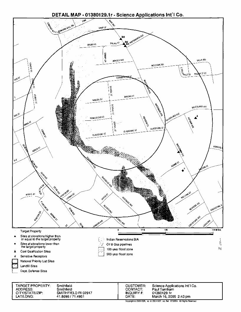
Elevations have been determined from the USGS Digital Elevation Model and should be evaluated on a relative (not an absolute) basis Relative elevation information between sites of close proximity should be field verified Sites with an elevation equal to or higher than the target property have been differentiated below from sites with an elevation lower than the target property Page numbers and map identification numbers refer to the EDR Radius Map report where detailed data on individual sites can be reviewed
Sites listed in bold italics are in multiple databases
Unmappable (orphan) sites are not considered in the foregoing analysis
TC013801291r EXECUTIVE SUMMARY 2
EXECUTIVE SUMMARY
FEDERAL ASTM STANDARD
NPL Also known as Superfund the National Priority List database is a subset of CERCLIS and identifies over 1200 sites for priority cleanup under the Superfund program The source of this database is the US EPA
A review of the NPL list as provided by EDR and dated 12142004 has revealed that there is 1 NPL site within approximately 1 mile of the target property
Lower Elevation Address Dist Dir Map ID Page
CENTREDALE MANOR RESTORATION P 2072 AND 2074 SMITH STR 12-1 SSE 18 12
RCRAInfo RCRAInfo is EPAs comprehensive information system providing access to data supporting the Resource Conservation and Recovery Act ( RCRA) of 1976 and the Hazardous and Solid Waste Amendments (HSWA) of 1984 RCRAInfo replaces the data recording and reporting abilities of the Resource Conservation and Recovery Information System(RCRIS) The database includes selective
information on sites which generate transport store treat andor dispose of hazardous waste as defined by the Resource Conservation and Recovery Act (RCRA) Conditionally exempt small quantity generators (CESQGs) generate less than 100 kg of hazardous waste or less than 1 kg of acutely hazardous waste per month Small quantity generators (SQGs) generate between 100 kg and 1000 kg of hazardous waste per month Large quantity generators generate over 1000 kilograms (kg) of hazardous waste or over 1 kg of acutely hazardous waste per month Transporters are individuals or entities that move hazardous waste from the generator offsite to a facility that can recycle treat store or dispose of the waste TSDFs treat store or dispose of the waste
A review of the RCRA-SQG list as provided by EDR and dated 11232004 has revealed that there are 4 RCRA-SQG sites within approximately 025 miles of the target property
EqualHigher Elevation
GOSETTIS AUTO REPAIRFAFINCSANTORO OIL COGYROS AUTOBODY
STATE ASTM STANDARD
Address
245 WATERMAN AVE 20 AUSTIN AVE
293 WATERMAN AVE 295 WATERMAN AVE
Dist Dir Map ID Page
18-14ESE A3 6 18-14E 4 7
18-14N B6 7 18-14N B8 9
SHWS The State Hazardous Waste Sites records The data come from the Dept of Env Management
A review of the SHWS list as provided by EDR has revealed that there are 10 SHWS sites within approximately 1 mile of the target property
EVANS PLATING 50 WATERMAN AVENUE 12-1 SSE 14 11 NARR ELECTRIC - CENTERDALE SUB 521 GEORGE WATERMAN ROA 12-1 SSE 15 11 METRO ATLANTICBROOK VILLAGE 2075 SMITH STREET 12-1 SSE D16 12 CENTREDALE MANOR 2072 SMITH STREET 12-1 SSE D17 12
LUST Leaking Underground Storage Tank Facilities
A review of the LUST list as provided by EDR and dated 10122004 has revealed that there are 2 LUST sites within approximately 05 miles of the target property
EqualHigher Elevation Address DistDir Map ID Page
ROUTE 44 MINI MART shy MOBIL 135 PUTNAM PIKE 14 - 12S 9 9
Lower Elevation Address DistDir Map ID Page
OCTEQU OIL COMPANY 7 ADAMS STREET 18-14SE 8
UST The Underground Storage Tank database contains registered USTs USTs are regulated under Subtitle I of the Resource Conservation and Recovery Act (RCRA) The data come from the Department of Environmental Managements Master List of UST Facilities amp Their Associated Tanks
A review of the UST list as provided by EDR and dated 02012005 has revealed that there are 3 UST sites within approximately 025 miles of the target property
EqualHigher Elevation Address Dist Dir Map ID Page
Due to poor or inadequate address information the following sites were not mapped
Site Name
ROSCITI ASSOCIATES PROPERTY NARR ELECTRIC - JOHNSTON SUBSTATIO AMERICAN DISPOSAL (VINAGRO) LANDFI CENTRAL LANDFILL BARREL NARR BAY COMMISSION INTERCEPTOR HARTFORD AVENUE GRAVEL PITS QUALITEX WPRO TRANSMITTER SITE NARR ELECTRIC - KILLINGLY RIGHT OF CHEMLAWN CECE-MACERA LANDFILL MACERA (ANTHONY) DISPOSAL SITE MACERA amp RUSSO PROPERTIES LOT 66 CENTRAL LANDFILL (RDRA OU1) DISPOSAL PITSPLAT 43 LOTS 43 AND U S ARMY RESERVE MAINT FAC CROSSLEY MANUFACTURING SMITHFIELD CHEMICAL IND DUMP LARK INDUSTRIAL PARK VINAGRO L LANDFILL CECE-MACERA LANDFILL U S ARMY RESERVE MAINTENANCE FAC NEW ENGLAND PRECISION PROD (D amp S PROVIDENCE BARREL PECK HILL ROAD SHUN PIKE CAMP STREET PUMP STATION SMITHFIELD WASTE WATER TREATMENT F SMITHFIELD INDUSTRIAL SITE (FORMER KATTANS MARKET GREENVILLE LIBRARY SCUNZIO CHEVROLET SMITHFIELD CHEMICAL INDUSTRIAL DUM CONGREGATON OF JEHOVAHS WITNESSES SMITHFIELD WASTEWATER TREATMENT FA SMITHFIELD FIRE DEPARTMENT MARSHALL CONTRACTORS CUMBERLAND FARMS INC 3804 SMITHFIELD OFFICE CENTER LLC
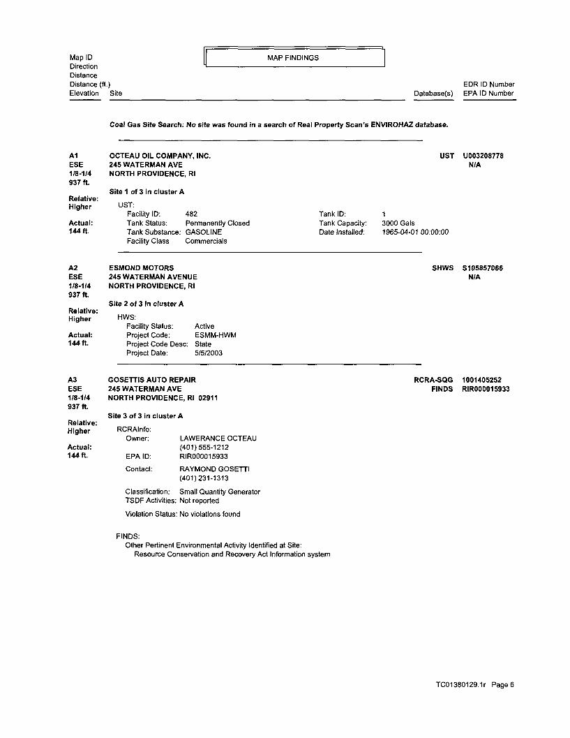
Owner PARKINSON REALTY LLC Actual (401)231-7100 144ft EPA ID RID001196682
Contact FRANCIS R NERNEY (401)231-7100
Classification Small Quantity Generator TSDF Activities Not reported
Violation Status No violations found
FINDS Other Pertinent Environmental Activity Identified at Site
Resource Conservation and Recovery Act Information system
HWS Facility Status Monitoring Project Code EPM-HWM Project Code Desc State Project Date Not reported
12 GREYSTONE AUTO CENTER SE 129 WATERMAN AVE 12-1 NORTH PROVIDENCE Rl 02911 2839 ft
Relative Lower
Actual 134ft
EDR ID Number Database(s) EPA ID Number
SHWS S103247458 NA
RCRA-SQG 1000882711 SHWS RID001196682 FINDS
RCRA-SQG 1000914233 SHWS RI5000000992 FINDS
TC013801291r Page 10
Map ID MAP FINDINGS Direction Distance Distance (ft) Elevation
13 SSE 12-1 2862 ft
Relative Lower
Actual 137ft
14 SSE 12-1 4154ft
Relative Lower
Actual 119ft
15 SSE 12-1 4699 ft
Relative Lower
Actual 124ft
Site
GREYSTONE AUTO CENTER (Continued)
RCRAInfo Owner EDWARD DENUCCIO
(401)943-1215 EPA ID RI5000000992
Contact NELSON BOUCHER
Classification Small Quantity Generator TSDF Activities Not reported
Violation Status No violations found
FINDS Other Pertinent Environmental Activity Identified at Site
Resource Conservation and Recovery Act Information system
HWS Facility StatusProject CodeProject Code DescProject Date
MEHAN CONSTRUCTION 79 PUTNAM AVE JOHNSTON Rl
HWS Facility StatusProject CodeProject Code DescProject Date
EVANS PLATING 50 WATERMAN AVENUE NORTH PROVIDENCE Rl
HWS Facility StatusProject CodeProject Code DescProject Date
Inactive GMO-HWM
State 4201994
Inactive MEH-HWM
State Not reported
02911
Active EVAN-HWM
State 721999
NARR ELECTRIC - CENTERDALE SUBSTATION 521 GEORGE WATERMAN ROAD JOHNSTON Rl
HWS Facility StatusProject CodeProject Code DescProject Date
Inactive NECE-HWM
State 6172003
EDR ID Number Database(s) EPA ID Number
1000914233
SHWS S103247069 NA
SHWS 1006538241 NA
SHWS S105990395 NA
TC013801291r Page 11
Map ID MAP FINDINGS Direction Distance Distance (ft) EDR ID Number Elevation Site Database(s) EPA ID Number
D16 SSE 12-1 4936 ft
Relative Lower
Actual 114ft
D17 SSE 12-1 4966 ft
Relative Lower
Actual 116ft
18 SSE 12-1 5163ft
Relative Lower
Actual 96ft
METRO ATLANTICBROOK VILLAGE 2075 SMITH STREET NORTH PROVIDENCE Rl
Site 1 of 2 In cluster D
HWS Facility Status Active Project Code META-HWM Project Code Desc State Project Date 1191998
CENTREDALE MANOR 2072 SMITH STREET NORTH PROVIDENCE Rl
Site 2 of 2 in cluster D
HWS Facility Status Active Project Code CLMN-NPL Project Code Desc National Priority List Project Date Not reported
Facility Status Active Project Code CLMN-NPL Project Code Desc National Priority List Project Date 4101986
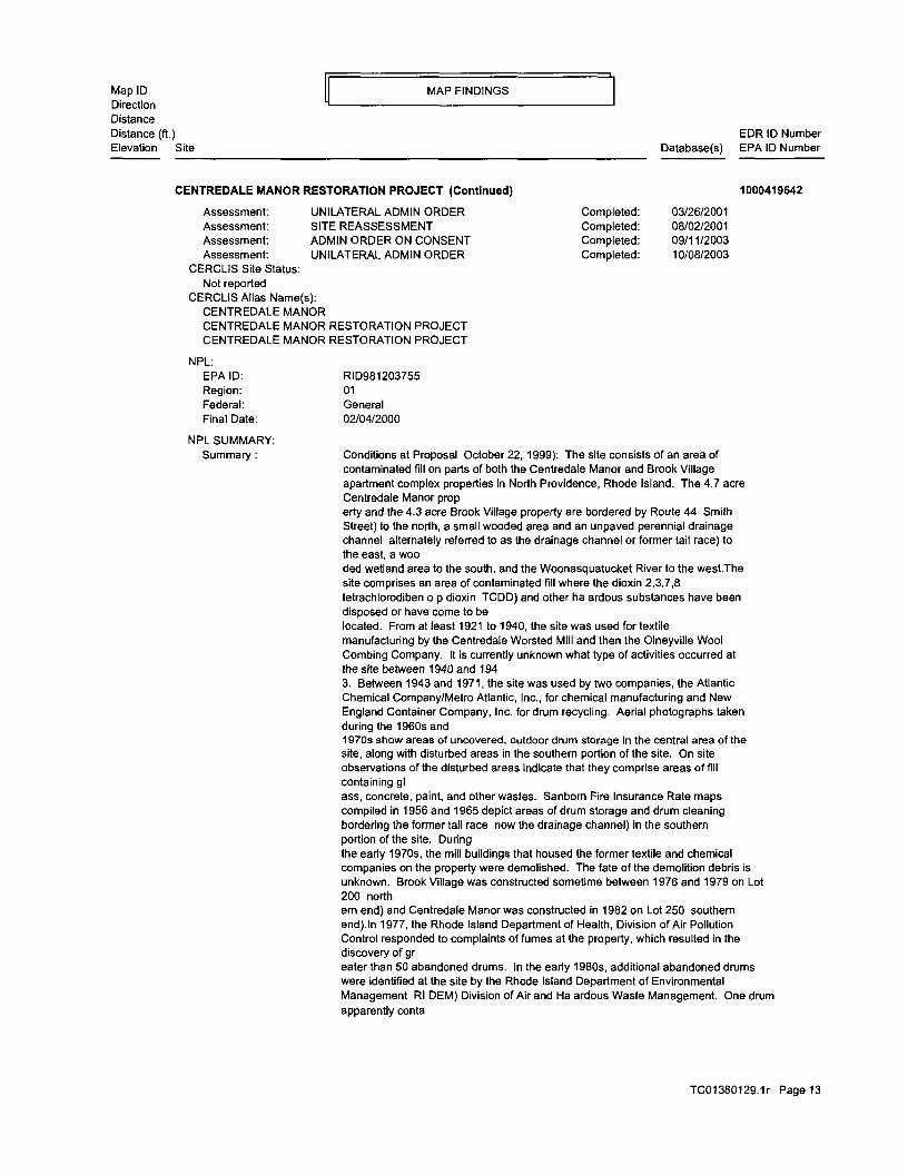
CENTREDALE MANOR RESTORATION PROJECT 2072 AND 2074 SMITH STREET (ROUTE 44) NORTH PROVIDENCE Rl 02911
CERCLIS Classification Data Site incident categor^Not reported Non NPL Status Not reported Ownership Status Private Contact TED BAZENAS Contact Title Not reported Contact Mike Jasinski Contact Title Not reported Contact Anna Krasko Contact Title Not reported
CERCLIS Assessment History Assessment DISCOVERY Assessment PRELIMINARY ASSESSMENT Assessment SITE INSPECTION Assessment EXPANDED SITE INSPECTION Assessment REMOVAL ASSESSMENT Assessment HRS PACKAGE Assessment PROPOSAL TO NPL Assessment FINAL LISTING ON NPL Assessment UNILATERAL ADMIN ORDER Assessment REMOVAL Assessment RIFS NEGOTIATIONS Assessment AERIAL SURVEY Assessment PRP REMOVAL Assessment ENGINEERING EVALCOST ANALYSIS
NPL EPA ID RID981203755 Region 01 Federal General Final Date 02042000
NPL SUMMARY Summary Conditions at Proposal October 221999) The site consists of an area of
contaminated fill on parts of both the Centredale Manor and Brook Village apartment complex properties in North Providence Rhode Island The 47 acre Centredale Manor prop erty and the 43 acre Brook Village property are bordered by Route 44 Smith Street) to the north a small wooded area and an unpaved perennial drainage channel alternately referred to as the drainage channel or former tail race) to the east a woo ded wetland area to the south and the Woonasquatucket River to the westThe site comprises an area of contaminated fill where the dioxin 2378 tetrachlorodiben o p dioxin TCDD) and other ha ardous substances have been disposed or have come to be located From at least 1921 to 1940 the site was used for textile manufacturing by the Centredale Worsted Mill and then the Olneyville Wool Combing Company It is currently unknown what type of activities occurred at the site between 1940 and 194 3 Between 1943 and 1971 the site was used by two companies the Atlantic Chemical CompanyMetro Atlantic Inc for chemical manufacturing and New England Container Company Inc for drum recycling Aerial photographs taken during the 1960s and 1970s show areas of uncovered outdoor drum storage in the central area of the site along with disturbed areas in the southern portion of the site On site observations of the disturbed areas indicate that they comprise areas of fill containing gl ass concrete paint and other wastes Sanborn Fire Insurance Rate maps compiled in 1956 and 1965 depict areas of drum storage and drum cleaning bordering the former tail race now the drainage channel) in the southern portion of the site During the early 1970s the mill buildings that housed the former textile and chemical companies on the property were demolished The fate of the demolition debris is unknown Brook Village was constructed sometime between 1976 and 1979 on Lot 200 north em end) and Centredale Manor was constructed in 1982 on Lot 250 southern end)In 1977 the Rhode Island Department of Health Division of Air Pollution Control responded to complaints of fumes at the property which resulted in the discovery of gr eater than 50 abandoned drums In the early 1980s additional abandoned drums were identified at the site by the Rhode Island Department of Environmental Management Rl DEM) Division of Air and Ha ardous Waste Management One drum apparently conta
TC013801291r Page 13
Map ID MAP FINDINGS Direction Distance Distance (ft) EDR ID Number Elevation Site Database(s) EPA ID Number
NPL Contaminant NPL Status Substance Id Case Num Substance Pathway GW Scoring SW Scoring Air Scoring Soil Scoring DC Scoring FE Scoring
ined polychlorinated biphenyls PCBs) while some drums may have contained an acid or caustic material based on the presence of polyliners) solvents and ink wastes A Notice of Violation was issued for violations of the State Ha ardous Waste Man agement Act In February 1982 approximately 300 drums were removed under the supervision of Rl DEMThe Woonasquatucket River borders the site to the west and a drainage channel borders to the east The drainage channel was formerly a channel that extended north of Route 44 diverting water for use at the Centredale Worsted Mill It is now blocked to the north of Route 44 and receives storm water runoff via a head wall at its northern end via overland flow from the eastern half of the site and via a drainage pipe from the roof of the Centredale Manor building The site includes portions of the Woonasquatucket River 10 year floodplain A low lying area in the west central portion of the site has been documented to flood during peri ods of high water for the Woonasquatucket River Surface water runoff from the site enters the Woonasquatucket River and drainage channel at numerous pointsContaminated fill an estimated 219869 square feet) at the site is located on a peninsula bounded by Route 44 to the north the Woonasquatucket River to the west the drainage channel to the east and extends approximately 135 feet south of the southernmost parking area to the south TCDD has been disposed or has come to be located on p arts of Lot 200 and Lot 250 Historical information indicates that former mill and drum recycling activities took place in portions of the area of contaminated fill The source of the ha ardous substances present in the contaminated fill is unknow n but is likely due to the largely unregulated use storage and disposal of ha ardous substances on the property from at least 1921 until 1977On February 16 and 171999 shallow soil samples were collected from the contaminated fill TCDD was d elected at concentrations up to 11582 parts per billion ppb) Additional analytical results from previous sampling events indicated the presence of volatile organic compounds semivolatile organic compounds pesticides PCBs and inorganic elemen ts in samples collected on or around Lot 200 and Lot 250 However for purposes of MRS scoring only the TCDD analytical results are evaluated at this timeStatus February 2000) EPA is considering various alternatives for this site The descript ion of the site release) is based on information available at the time the site was scored The description may change as additional information is gathered on the sources and extent of contamination See 56 FR 5600 February 11 1991 or subsequ ent FR notices
Final Z019 Not reported TETRACHLORODIBENZO-P-DIOXIN SOIL Not reported Not reported Not reported Observed Release amp Toxicity Not reported Not reported
TC013801291r Page 14
Map ID MAP FINDINGS Direction Distance Distance (ft) EDR ID Number Elevation Site Database(s) EPA ID Number
NPL Status Final Substance Id Z019 Case Num Not reported Substance TETRACHLORODIBENZO-P-DIOXIN Pathway SW GW Scoring Not reported SW Scoring Observed Release amp Toxicity Air Scoring Not reported Soil Scoring Not reported DC Scoring Not reported FE Scoring Not reported
NPL Site CERCLIS Id RID981203755 Site City North Providence Site State Rl NPL Status Final Status Date 020400 Federal Site Not reported HRS Score 7071 GW Score 000 SW Score 10000 Air Score 000 Soil Score 10000 DC Score 000 FE Score 00
NPL Char NPL Status Final Category Description DEPTH TO AQUIFER Category Value Unknown
NPL Status Final Category Description DISTANCE TO NEAREST POPULATION Category Value OMile
NPL Status Final Category Description OBSERVED RELEASE-Soil Exposure Category Value Not reported
NPL Status Final Category Description OBSERVED RELEASE-Surface Water Category Value Not reported
NPL Status Final Category Description OBSERVED RELEASE-Surface Water Overland Flood Threat Category Value Not reported
NPL Status Final Category Description OTHER GROUND WATER USE-Other Category Value BOTTLD H2O
NPL Status Final Category Description PHYSICAL STATE-Liquid Category Value Not reported
NPL Status Final Category Description PHYSICAL STATE-Solid Category Value Not reported
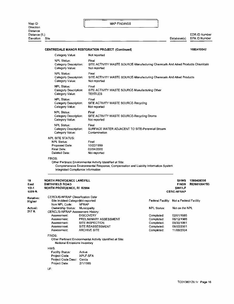
NPL Status Final Category Description SITE ACTIVITY WASTE SOURCE-Manufacturing
TC013801291r Page 15
Map ID MAP FINDINGS Direction Distance Distance (ft) EDR ID Number Elevation
NPL Status Final Category Description SITE ACTIVITY WASTE SOURCE-Manufacturing Chemicals And Allied Products Chemicals Category Value Not reported
NPL Status Final Category Description SITE ACTIVITY WASTE SOURCE-Manufacturing Chemicals And Allied Products Category Value Not reported
NPL Status Final Category Description SITE ACTIVITY WASTE SOURCE-Manufacturing Other Category Value TEXTILES
NPL Status Final Category Description SITE ACTIVITY WASTE SOURCE-Recycling Category Value Not reported
NPL Status Final Category Description SITE ACTIVITY WASTE SOURCE-Recycling Drums Category Value Not reported
NPL Status Final Category Description SURFACE WATER ADJACENT TO SITE-Perennial Stream Category Value Contamination
NPL SITE STATUS NPL Status Final Proposed Date 10221999 Final Date 02042000 Deleted Date Not reported
FINDS Other Pertinent Environmental Activity Identified at Site
Comprehensive Environmental Response Compensation and Liability Information System Integrated Compliance Information
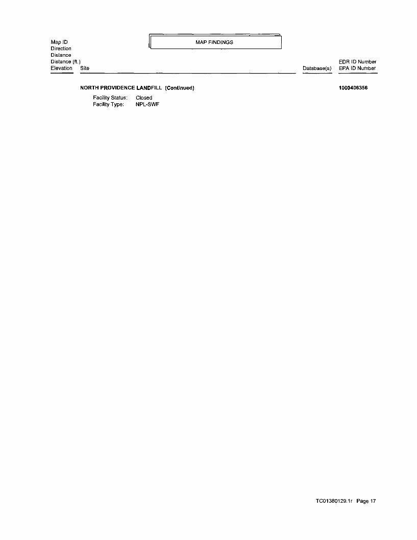
NORTH PROVIDENCE LANDFILL SHWS 1000406356 SMITHFIELD ROAD FINDS RID981064793 NORTH PROVIDENCE Rl 02904 SWFLF
CERC-NFRAP
CERCLIS-NFRAP Classification Data Site Incident Categongtlot reported Federal Facility Not a Federal Facility Non NPL Code NFRAP Ownership Status Municipality NPL Status Not on the NPL
CERCLIS-NFRAP Assessment History Assessment DISCOVERY Completed 02011985 Assessment PRELIMINARY ASSESSMENT Completed 06121986 Assessment SITE INSPECTION Completed 09301991 Assessment SITE REASSESSMENT Completed 08022001 Assessment ARCHIVE SITE Completed 11092004
FINDS Other Pertinent Environmental Activity Identified at Site
National Emissions Inventory
HWS Facility Status Active Project Code NPLF-SFA Project Code Desc Cercla Project Date 211985
LF
TC013801291r Page 16
Map ID MAP FINDINGS Direction Distance Distance (ft) EDR ID Number Elevation Site Database(s) EPA ID Number
SMITHFIELD S101360966 CAMP STREET PUMP STATION CAMP STREET LUST
SMITHFIELD U003935933 SMITHFIELD CHEMICAL INDUSTRIAL DUM DEERFIELD DR UST
SMITHFIELD S103247461 SMITHFIELD CHEMICAL IND DUMP DEERFIELD DRIVE SHWS
SMITHFIELD 1005649029 SMITHFIELD OFFICE CENTER LLC DOUGLAS PIKE (ROUTE 7) 02917 FINDS
SMITHFIELD U002311773 CONGREGATON OF JEHOVAHS WITNESSES EDDIE DOWLING HWY UST
SMITHFIELD U001713965 SMITHFIELD WASTEWATER TREATMENT FA ESMOND MILL DR UST
SMITHFIELD S106664397 SMITHFIELD WASTE WATER TREATMENT F ESMOND MILL ROAD LUST
SMITHFIELD 1000130811 NEW ENGLAND PRECISION PROD (D amp S FARNUM PIKE 02917 CERCLIS RCRA-SQG FINDS
SMITHFIELD S104943074 LARK INDUSTRIAL PARK 24 LARK INDUSTRIAL PARK SHWS
SMITHFIELD S106664396 SMITHFIELD INDUSTRIAL SITE (FORMER LISA ANN CIRCLE LUST
SMITHFIELD U001211101 SMITHFIELD FIRE DEPARTMENT LOGRD UST
SMITHFIELD 1000432937 PROVIDENCE BARREL OAK STREET 02917 CERCLIS FINDS
TC013801291r Page 18
GOVERNMENT RECORDS SEARCHED DATA CURRENCY TRACKING
To maintain currency of the following federal and state databases EDR contacts the appropriate governmental agency on a monthly or quarterly basis as required
Elapsed ASTM days Provides confirmation that this EDR report meets or exceeds the 90-day updating requirement of the ASTM standard
FEDERAL ASTM STANDARD RECORDS
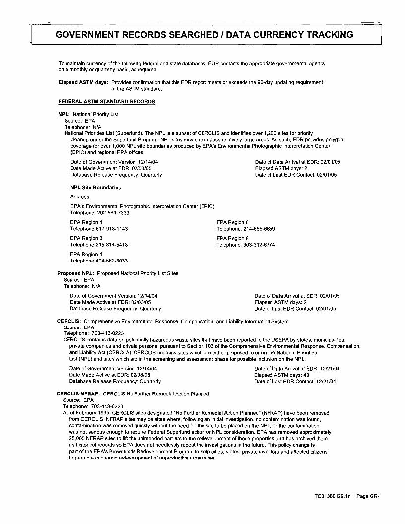
NPL National Priority List Source EPA Telephone NA National Priorities List (Superfund) The NPL is a subset of CERCLIS and identifies over 1200 sites for priority
cleanup under the Superfund Program NPL sites may encompass relatively large areas As such EDR provides polygon coverage for over 1000 NPL site boundaries produced by EPAs Environmental Photographic Interpretation Center (EPIC) and regional EPA offices
Date of Government Version 121404 Date Made Active at EDR 020305 Database Release Frequency Quarterly
Date of Data Arrival at EDR 020105 Elapsed ASTM days 2 Date of Last EDR Contact 020105
NPL Site Boundaries
Sources
EPAs Environmental Photographic Interpretation Center (EPIC) Telephone 202-564-7333
EPA Region 1 EPA Region 6 Telephone 617-918-1143 Telephone 214-655-6659
EPA Region 3 EPA Region 8 Telephone 215-814-5418 Telephone 303-312-6774
EPA Region 4 Telephone 404-562-8033
Proposed NPL Proposed National Priority List Sites Source EPA Telephone NA
Date of Government Version 121404 Date of Data Arrival at EDR 020105 Date Made Active at EDR 020305 Elapsed ASTM days 2 Database Release Frequency Quarterly Date of Last EDR Contact 020105
CERCLIS Comprehensive Environmental Response Compensation and Liability Information System Source EPA Telephone 703-413-0223 CERCLIS contains data on potentially hazardous waste sites that have been reported to the USEPA by states municipalities
private companies and private persons pursuant to Section 103 of the Comprehensive Environmental Response Compensation and Liability Act (CERCLA) CERCLIS contains sites which are either proposed to or on the National Priorities List (NPL) and sites which are in the screening and assessment phase for possible inclusion on the NPL
Date of Government Version 121404 Date of Data Arrival at EDR 122104 Date Made Active at EDR 020805 Elapsed ASTM days 49 Database Release Frequency Quarterly Date of Last EDR Contact 122104
CERCLIS-NFRAP CERCLIS No Further Remedial Action Planned Source EPA Telephone 703-413-0223 As of February 1995 CERCLIS sites designated No Further Remedial Action Planned (NFRAP) have been removed
from CERCLIS NFRAP sites may be sites where following an initial investigation no contamination was found contamination was removed quickly without the need for the site to be placed on the NPL or the contamination was not serious enough to require Federal Superfund action or NPL consideration EPA has removed approximately 25000 NFRAP sites to lift the unintended barriers to the redevelopment of these properties and has archived them as historical records so EPA does not needlessly repeat the investigations in the future This policy change is part of the EPAs Brownfields Redevelopment Program to help cities states private investors and affected citizens to promote economic redevelopment of unproductive urban sites
TC013801291r Page GR-1
GOVERNMENT RECORDS SEARCHED DATA CURRENCY TRACKING
Date of Government Version 121404 Date of Data Arrival at EDR 122104 Date Made Active at EDR 020805 Elapsed ASTM days 49 Database Release Frequency Quarterly Date of Last EDR Contact 122104
Date of Government Version 121504 Date of Data Arrival at EDR 010705 Date Made Active at EDR 022505 Elapsed ASTM days 49 Database Release Frequency Quarterly Date of Last EDR Contact 120704
RCRA Resource Conservation and Recovery Act Information Source EPA Telephone 800-424-9346 RCRAInfo is EPAs comprehensive information system providing access to data supporting the Resource Conservation
and Recovery Act (RCRA) of 1976 and the Hazardous and Solid Waste Amendments (HSWA) of 1984 RCRAInfo replaces the data recording and reporting abilities of the Resource Conservation and Recovery Information System (RCRIS) The database includes selective information on sites which generate transport store treat andor dispose of hazardous waste as defined by the Resource Conservation and Recovery Act (RCRA) Conditionally exempt small quantity generators (CESQGs) generate less than 100 kg of hazardous waste or less than 1 kg of acutely hazardous waste per month Small quantity generators (SQGs) generate between 100 kg and 1000 kg of hazardous waste per month Large quantity generators (LQGs) generate over 1000 kilograms (kg) of hazardous waste or over 1 kg of acutely hazardous waste per month Transporters are individuals or entities that move hazardous waste from the generator off-site to a facility that can recycle treat store or dispose of the waste TSDFs treat store or dispose of the waste
Date of Government Version 112304 Date of Data Arrival at EDR 112404 Date Made Active at EDR 011805 Elapsed ASTM days 55 Database Release Frequency Quarterly Date of Last EDR Contact 112404
ERNS Emergency Response Notification System Source National Response Center United States Coast Guard Telephone 202-260-2342 Emergency Response Notification System ERNS records and stores information on reported releases of oil and hazardous
substances
Date of Government Version 123103 Date of Data Arrival at EDR 012604 Date Made Active at EDR 031204 Elapsed ASTM days 46 Database Release Frequency Annually Date of Last EDR Contact 012705
FEDERAL ASTM SUPPLEMENTAL RECORDS
BRS Biennial Reporting System Source EPANTIS Telephone 800-424-9346 The Biennial Reporting System is a national system administered by the EPA that collects data on the generation
and management of hazardous waste BRS captures detailed data from two groups Large Quantity Generators (LOG) and Treatment Storage and Disposal Facilities
Date of Government Version 120101 Date of Last EDR Contact 121304 Database Release Frequency Biennially Date of Next Scheduled EDR Contact 031405
CONSENT Superfund (CERCLA) Consent Decrees Source Department of Justice Consent Decree Library Telephone Varies Major legal settlements that establish responsibility and standards for cleanup at NPL (Superfund) sites Released
periodically by United States District Courts after settlement by parties to litigation matters
TC013801291 r Page GR-2
GOVERNMENT RECORDS SEARCHED DATA CURRENCY TRACKING
Date of Government Version 030504 Date of Last EDR Contact 102504 Database Release Frequency Varies Date of Next Scheduled EDR Contact 012405
ROD Records Of Decision Source EPA Telephone 703-416-0223 Record of Decision ROD documents mandate a permanent remedy at an NPL (Superfund) site containing technical
and health information to aid in the cleanup
Date of Government Version 090904 Date of Last EDR Contact 010505 Database Release Frequency Annually Date of Next Scheduled EDR Contact 040405
DELISTED NPL National Priority List Deletions Source EPA Telephone NA The National Oil and Hazardous Substances Pollution Contingency Plan (NCP) establishes the criteria that the
EPA uses to delete sites from the NPL In accordance with 40 CFR 300425(e) sites may be deleted from the NPL where no further response is appropriate
Date of Government Version 121404 Date of Last EDR Contact 020105 Database Release Frequency Quarterly Date of Next Scheduled EDR Contact 050205
FINDS Facility Index SystemFacility Identification Initiative Program Summary Report Source EPA Telephone NA Facility Index System FINDS contains both facility information and pointers to other sources that contain more
detail EDR includes the following FINDS databases in this report PCS (Permit Compliance System) AIRS (Aerometric Information Retrieval System) DOCKET (Enforcement Docket used to manage and track information on civil judicial enforcement cases for all environmental statutes) FURS (Federal Underground Injection Control) C-DOCKET (Criminal Docket System used to track criminal enforcement actions for all environmental statutes) FFIS (Federal Facilities Information System) STATE (State Environmental Laws and Statutes) and PADS (PCB Activity Data System)
Date of Government Version 011205 Date of Last EDR Contact 010305 Database Release Frequency Quarterly Date of Next Scheduled EDR Contact 040405
HMIRS Hazardous Materials Information Reporting System Source US Department of Transportation Telephone 202-366-4555 Hazardous Materials Incident Report System HMIRS contains hazardous material spill incidents reported to DOT
Date of Government Version 090804 Date of Last EDR Contact 011905 Database Release Frequency Annually Date of Next Scheduled EDR Contact 041805
MLTS Material Licensing Tracking System Source Nuclear Regulatory Commission Telephone 301-415-7169 MLTS is maintained by the Nuclear Regulatory Commission and contains a list of approximately 8100 sites which
possess or use radioactive materials and which are subject to NRC licensing requirements To maintain currency EDR contacts the Agency on a quarterly basis
Date of Government Version 113004 Date of Last EDR Contact 010305 Database Release Frequency Quarterly Date of Next Scheduled EDR Contact 040405
MINES Mines Master Index File Source Department of Labor Mine Safety and Health Administration Telephone 303-231-5959 Contains all mine identification numbers issued for mines active or opened since 1971 The data also includes
violation information
TC013801291r Page GR-3
GOVERNMENT RECORDS SEARCHED DATA CURRENCY TRACKING
Date of Government Version 111505 Date of Last EDR Contact 122804 Database Release Frequency Semi-Annually Date of Next Scheduled EDR Contact 032805
NPL LIENS Federal Superfund Liens Source EPA Telephone 202-564-4267 Federal Superfund Liens Under the authority granted the USEPA by the Comprehensive Environmental Response Compensation
and Liability Act (CERCLA) of 1980 the USEPA has the authority to file liens against real property in order to recover remedial action expenditures or when the property owner receives notification of potential liability USEPA compiles a listing of filed notices of Superfund Liens
Date of Government Version 101591 Date of Last EDR Contact 022205 Database Release Frequency No Update Planned Date of Next Scheduled EDR Contact 052305
of PCBs who are required to notify the EPA of such activities
Date of Government Version 093004 Date of Last EDR Contact 022305 Database Release Frequency Annually Date of Next Scheduled EDR Contact 050905
DOD Department of Defense Sites Source USGS Telephone 703-692-8801 This data set consists of federally owned or administered lands administered by the Department of Defense that
have any area equal to or greater than 640 acres of the United States Puerto Rico and the US Virgin Islands
Date of Government Version 100103 Date of Last EDR Contact 020805 Database Release Frequency Semi-Annually Date of Next Scheduled EDR Contact 050905
UMTRA Uranium Mill Tailings Sites Source Department of Energy Telephone 505-845-0011 Uranium ore was mined by private companies for federal government use in national defense programs When the mills
shut down large piles of the sand-like material (mill tailings) remain after uranium has been extracted from the ore Levels of human exposure to radioactive materials from the piles are low however in some cases tailings were used as construction materials before the potential health hazards of the tailings were recognized In 1978 24 inactive uranium mill tailings sites in Oregon Idaho Wyoming Utah Colorado New Mexico Texas North Dakota South Dakota Pennsylvania and on Navajo and Hopi tribal lands were targeted for cleanup by the Department of Energy
Date of Government Version 122904 Date of Last EDR Contact 122104 Database Release Frequency Varies Date of Next Scheduled EDR Contact 032105
ODI Open Dump Inventory Source Environmental Protection Agency Telephone 800-424-9346 An open dump is defined as a disposal facility that does not comply with one or more of the Part 257 or Part 258
Subtitle D Criteria
Date of Government Version 063085 Date of Last EDR Contact 052395 Database Release Frequency No Update Planned Date of Next Scheduled EDR Contact NA
FUDS Formerly Used Defense Sites Source US Army Corps of Engineers Telephone 202-528-4285 The listing includes locations of Formerly Used Defense Sites properties where the US Army Corps of Engineers
is actively working or will take necessary cleanup actions
TC013801291r Page GR-4
GOVERNMENT RECORDS SEARCHED DATA CURRENCY TRACKING
Date of Government Version 123103 Date of Last EDR Contact 010305 Database Release Frequency Varies Date of Next Scheduled EDR Contact 040405
INDIAN RESERV Indian Reservations Source USGS Telephone 202-208-3710 This map layer portrays Indian administered lands of the United States that have any area equal to or greater
than 640 acres
Date of Government Version 100103 Date of Last EDR Contact 020805 Database Release Frequency Semi-Annually Date of Next Scheduled EDR Contact 050905
RAATS RCRA Administrative Action Tracking System Source EPA Telephone 202-564-4104 RCRA Administration Action Tracking System RAATS contains records based on enforcement actions issued under RCRA
pertaining to major violators and includes administrative and civil actions brought by the EPA For administration actions after September 301995 data entry in the RAATS database was discontinued EPA will retain a copy of the database for historical records It was necessary to terminate RAATS because a decrease in agency resources made it impossible to continue to update the information contained in the database
Date of Government Version 041795 Date of Last EDR Contact 120604 Database Release Frequency No Update Planned Date of Next Scheduled EDR Contact 030705
TRIS Toxic Chemical Release Inventory System Source EPA Telephone 202-566-0250 Toxic Release Inventory System TRIS identifies facilities which release toxic chemicals to the air water and
land in reportable quantities under SARA Title III Section 313
Date of Government Version 123102 Date of Last EDR Contact 122004 Database Release Frequency Annually Date of Next Scheduled EDR Contact 032105
TSCA Toxic Substances Control Act Source EPA Telephone 202-260-5521 Toxic Substances Control Act TSCA identifies manufacturers and importers of chemical substances included on the
TSCA Chemical Substance Inventory list It includes data on the production volume of these substances by plant site
Date of Government Version 123102 Date of Last EDR Contact 120604 Database Release Frequency Every 4 Years Date of Next Scheduled EDR Contact 030705
Date of Government Version 041304 Date of Last EDR Contact 120104 Database Release Frequency Quarterly Date of Next Scheduled EDR Contact 032105
SSTS Section 7 Tracking Systems Source EPA Telephone 202-564-5008 Section 7 of the Federal Insecticide Fungicide and Rodenticide Act as amended (92 Stat 829) requires all
registered pesticide-producing establishments to submit a report to the Environmental Protection Agency by March 1st each year Each establishment must report the types and amounts of pesticides active ingredients and devices being produced and those having been produced and sold or distributed in the past year
Date of Government Version 123103 Date of Last EDR Contact 112904 Database Release Frequency Annually Date of Next Scheduled EDR Contact 041805
TC013801291r Page GR-5
GOVERNMENT RECORDS SEARCHED DATA CURRENCY TRACKING
FTTS FIFRA TSCA Tracking System - FIFRA (Federal Insecticide Fungicide amp Rodenticide Act)TSCA (Toxic Substances Control Act) Source EPAOffice of Prevention Pesticides and Toxic Substances Telephone 202-564-2501 FTTS tracks administrative cases and pesticide enforcement actions and compliance activities related to FIFRA
TSCA and EPCRA (Emergency Planning and Community Right-to-Know Act) To maintain currency EDR contacts the Agency on a quarterly basis
Date of Government Version 091304 Date of Last EDR Contact 120104 Database Release Frequency Quarterly Date of Next Scheduled EDR Contact 032105
STATE OF RHODE ISLAND ASTM STANDARD RECORDS
SHWS State Hazardous Waste Sites Source Department of Environmental Management Telephone 401-222-3872 State Hazardous Waste Sites State hazardous waste site records are the states equivalent to CERCLIS These sites
may or may not already be listed on the federal CERCLIS list Priority sites planned for cleanup using state funds (state equivalent of Superfund) are identified along with sites where cleanup will be paid for by potentially responsible parties Available information varies by state
Date of Government Version 101204 Date of Data Arrival at EDR 120104 Date Made Active at EDR 122904 Elapsed ASTM days 28 Database Release Frequency Quarterly Date of Last EDR Contact 030205
SWFLF Solid Waste Management Facilities Source Department of Environmental Management Telephone 401-222-2797 Solid Waste FacilitiesLandfill Sites SWFLF type records typically contain an inventory of solid waste disposal
facilities or landfills in a particular state Depending on the state these may be active or inactive facilities or open dumps that failed to meet RCRA Subtitle D Section 4004 criteria for solid waste landfills or disposal sites
Date of Government Version 100804 Date of Data Arrival at EDR 112904 Date Made Active at EDR 122904 Elapsed ASTM days 30 Database Release Frequency Quarterly Date of Last EDR Contact 030205
LUST Leaking Underground Storage Tank Facilities Source Department of Environmental Management Telephone 401-222-3872 Leaking Underground Storage Tank Incident Reports LUST records contain an inventory of reported leaking underground
storage tank incidents Not all states maintain these records and the information stored varies by state
Date of Government Version 101204 Date of Data Arrival at EDR 120104 Date Made Active at EDR 122904 Elapsed ASTM days 28 Database Release Frequency Quarterly Date of Last EDR Contact 030205
UST Underground Storage Tank Facility Master List Source Department of Environmental Management Telephone 401-222-2797 Registered Underground Storage Tanks USTs are regulated under Subtitle I of the Resource Conservation and Recovery
Act (RCRA) and must be registered with the state department responsible for administering the UST program Available information varies by state program
Date of Government Version 020105 Date of Data Arrival at EDR 021005 Date Made Active at EDR 022105 Elapsed ASTM days 11 Database Release Frequency Quarterly Date of Last EDR Contact 123104
TC013801291r Page GR-6
GOVERNMENT RECORDS SEARCHED DATA CURRENCY TRACKING
STATE OF RHODE ISLAND ASTM SUPPLEMENTAL RECORDS
AST Aboveground Storage Tanks Source Department of Environmental Management Telephone 401-222-3872 Registered Aboveground Storage Tanks
Date of Government Version 071404 Date of Last EDR Contact 120604 Database Release Frequency Semi-Annually Date of Next Scheduled EDR Contact 030705
SPILLS Oil amp Hazardous Material Response LogSpill Report Source Dept of Environmental Management Telephone 401-222-3872
Date of Government Version 123103 Date of Last EDR Contact 011005 Database Release Frequency Varies Date of Next Scheduled EDR Contact 041105
EDR PROPRIETARY HISTORICAL DATABASES
Former Manufactured Gas (Coal Gas) Sites The existence and location of Coal Gas sites is provided exclusively to EDR by Real Property Scan Inc copyCopyright 1993 Real Property Scan Inc For a technical description of the types of hazards which may be found at such sites contact your EDR customer service representative
Disclaimer Provided by Real Property Scan Inc
The information contained in this report has predominantly been obtained from publicly available sources produced by entities other than Real Property Scan While reasonable steps have been taken to insure the accuracy of this report Real Property Scan does not guarantee the accuracy of this report Any liability on the part of Real Property Scan is strictly limited to a refund of the amount paid No claim is made for the actual existence of toxins at any site This report does not constitute a legal opinion
BROWNFIELDS DATABASES
Brownfields Brownfields Site List Source Department of Environmental Management Telephone 401-222-2797 Brownfields are real properties where the expansion redevelopment or reuse may be complicated by the actual or
potential presence of a hazardous substance pollutant or contaminat
Date of Government Version 100203 Date of Last EDR Contact 030205 Database Release Frequency Semi-Annually Date of Next Scheduled EDR Contact 050205
INST CONTROL ELUR Listing Source Department of Environmental Management Telephone 401-222-2797 Environmental Land Use Restriction is the legal document placed in land evidence records that restricts a property
to certain uses that are consistent with the approved Remediation Action Work Plan
Date of Government Version 120604 Date of Last EDR Contact 120604 Database Release Frequency Varies Date of Next Scheduled EDR Contact 030705
US BROWNFIELDS A Listing of Brownfields Sites Source Environmental Protection Agency Telephone 202-566-2777 Included in the listing are brownfields properties addresses by Cooperative Agreement Recipients and brownfields
properties addressed by Targeted Brownfields Assessments Targeted Brownfields Assessments-EPAs Targeted Brownfields Assessments (TEA) program is designed to help states tribes and municipalities-especially those without EPA Brownfields Assessment Demonstration Pilots-minimize the uncertainties of contamination often associated with brownfields Under the TBA program EPA provides funding andor technical assistance for environmental assessments at brownfields sites throughout the country Targeted Brownfields Assessments supplement and work with other efforts under EPAs Brownfields Initiative to promote cleanup and redevelopment of brownfields Cooperative Agreement Recipients-States political subdivisions territories and Indian tribes become Brownfields Cleanup Revolving Loan Fund (BCRLF) cooperative agreement recipients when they enter into BCRLF cooperative agreements with the US EPA EPA selects BCRLF cooperative agreement recipients based on a proposal and application process BCRLF cooperative agreement recipients must use EPA funds provided through BCRLF cooperative agreement for specified brownfields-related cleanup activities
TC013801291r Page GR-7
GOVERNMENT RECORDS SEARCHED DATA CURRENCY TRACKING
Date of Government Version NA Date of Last EDR Contact NA Database Release Frequency Semi-Annually Date of Next Scheduled EDR Contact NA
OTHER DATABASE(S)
Depending on the geographic area covered by this report the data provided in these specialty databases may or may not be complete For example the existence of wetlands information data in a specific report does not mean that all wetlands in the area covered by the report are included Moreover the absence of any reported wetlands information does not necessarily mean that wetlands do not exist in the area covered by the report
OilGas Pipelines This data was obtained by EDR from the USGS in 1994 It is referred to by USGS as GeoData Digital Line Graphs from 1100000-Scale Maps It was extracted from the transportation category including some oil but primarily gas pipelines
Electric Power Transmission Line Data Source PennWell Corporation Telephone (800) 823-6277 This map includes information copyrighted by PennWell Corporation This information is provided on a best effort basis and PennWell Corporation does not guarantee its accuracy nor warrant its fitness for any particular purpose Such information has been reprinted with the permission of PennWell
Sensitive Receptors There are individuals deemed sensitive receptors due to their fragile immune systems and special sensitivity to environmental discharges These sensitive receptors typically include the elderly the sick and children While the location of all sensitive receptors cannot be determined EDR indicates those buildings and facilities - schools daycares hospitals medical centers and nursing homes - where individuals who are sensitive receptors are likely to be located
AHA Hospitals Source American Hospital Association Inc Telephone 312-280-5991 The database includes a listing of hospitals based on the American Hospital Associations annual survey of hospitals
Medical Centers Provider of Services Listing Source Centers for Medicare amp Medicaid Services Telephone 410-786-3000 A listing of hospitals with Medicare provider number produced by Centers of Medicare amp Medicaid Services a federal agency within the US Department of Health and Human Services
Nursing Homes Source National Institutes of Health Telephone 301-594-6248 Information on Medicare and Medicaid certified nursing homes in the United States
Public Schools Source National Center for Education Statistics Telephone 202-502-7300 The National Center for Education Statistics primary database on elementary and secondary public education in the United States It is a comprehensive annual national statistical database of all public elementary and secondary schools and school districts which contains data that are comparable across all states
Private Schools Source National Center for Education Statistics Telephone 202-502-7300 The National Center for Education Statistics primary database on private school locations in the United States
Daycare Centers Day Care Provider Listing Source Department of Children Youth amp Families Telephone 401-528-3624
Flood Zone Data This data available in select counties across the country was obtained by EDR in 1999 from the Federal Emergency Management Agency (FEMA) Data depicts 100-year and 500-year flood zones as defined by FEMA
NWI National Wetlands Inventory This data available in select counties across the country was obtained by EDR in 2002 from the US Fish and Wildlife Service
TC013801291 r Page GR-8
GOVERNMENT RECORDS SEARCHED DATA CURRENCY TRACKING
STREET AND ADDRESS INFORMATION
copy 2003 Geographic Data Technology Inc Rel 072003 This product contains proprietary and confidential property of Geographic Data Technology Inc Unauthorized use including copying for other than testing and standard backup procedures of this product is expressly prohibited
TC013801291r Page GR-9
TABLE OF CONTENTS
SECTION PAGE
Executive Summary ES1
Overview Map 2
Detail Map 3
Map Findings Summary 4
Map Findings 6
Orphan Summary 18
Government Records SearchedData Currency Tracking GR-1
GEOCHECK ADDENDUM
GeoCheck - Not Requested
Thank you for your business Please contact EDR at 1-800-352-0050
with any questions or comments
Disclaimer - Copyright and Trademark Notice This Report contains certain information obtained from a variety of public and other sources reasonably available to Environmental Data Resources Inc It cannot be concluded from this Report that coverage information for the target and surrounding properties does not exist from Other sources NO WARRANTY EXPRESSED OR IMPLIED IS MADE WHATSOEVER IN CONNECTION WITH THIS REPORT ENVIRONMENTAL DATA RESOURCES INC SPECIFICALLY DISCLAIMS THE MAKING OF ANY SUCH WARRANTIES INCLUDING WITHOUT LIMITATION MERCHANTABILITY OR FITNESS FOR A PARTICULAR USE OR PURPOSE ALL RISK IS ASSUMED BY THE USER IN NO EVENT SHALL ENVIRONMENTAL DATA RESOURCES INC BE LIABLE TO ANYONE WHETHER ARISING OUT OF ERRORS OR OMISSIONS NEGLIGENCE ACCIDENT OR ANY OTHER CAUSE FOR ANY LOSS OF DAMAGE INCLUDING WITHOUT LIMITATION SPECIAL INCIDENTAL CONSEQUENTIAL OR EXEMPLARY DAMAGES ANY LIABILITY ON THE PART OF ENVIRONMENTAL DATA RESOURCES INC IS STRICTLY LIMITED TO A REFUND OF THE AMOUNT PAID FOR THIS REPORT Purchaser accepts this Report AS IS Any analyses estimates ratings environmental risk levels or risk codes provided in this Report are provided for illustrative purposes only and are not intended to provide nor should they be interpreted as providing any facts regarding or prediction or forecast of any environmental risk for any property Only a Phase I Environmental Site Assessment performed by an environmental professional can provide information regarding the environmental risk for any property Additionally the information provided in this Report is not to be construed as legal advice
Copyright 2005 by Environmental Data Resources Inc All rights reserved Reproduction in any media or format in whole or in part of any report or map of Environmental Data Resources Inc or its affiliates is prohibited without prior written permission EDR and its logos (including Sanborn and Sanborn Map) are trademarks of Environmental Data Resources Inc or its affiliates All other trademarks used herein are the property of their respective owners
TC013801291r Page 1
EXECUTIVE SUMMARY
A search of available environmental records was conducted by Environmental Data Resources Inc (EDR) The report meets the government records search requirements of ASTM Standard Practice for Environmental Site Assessments E 1527-00 Search distances are per ASTM standard or custom distances requested by the user
TARGET PROPERTY INFORMATION
ADDRESS
SMITHFIELD SMITHFIELD Rl 02917
COORDINATES
Latitude (North) 41869900 - 41 52 116 Longitude (West) 71495100 - 71 29 424 Universal Tranverse Mercator Zone 19 UTM X (Meters) 2929284 UTM Y (Meters) 46381285 Elevation 141 ft above sea level
USGS TOPOGRAPHIC MAP ASSOCIATED WITH TARGET PROPERTY
Target Property 41071-G4 PROVIDENCE Rl Source USGS 75 min quad index
TARGET PROPERTY SEARCH RESULTS
The target property was not listed in any of the databases searched by EDR
DATABASES WITH NO MAPPED SITES
No mapped sites were found in EDRs search of available ( reasonably ascertainable ) government records either on the target property or within the ASTM E 1527-00 search radius around the target property for the following databases
FEDERAL ASTM STANDARD
Proposed NPL Proposed National Priority List Sites CERCLIS Comprehensive Environmental Response Compensation and Liability Information
System CERC-NFRAP CERCLIS No Further Remedial Action Planned CORRACTS Corrective Action Report RCRA-TSDF Resource Conservation and Recovery Act Information RCRA-LQG Resource Conservation and Recovery Act Information ERNS Emergency Response Notification System
STATE ASTM STANDARD
SWFLF Solid Waste Management Facilities
TC013801291r EXECUTIVE SUMMARY 1
EXECUTIVE SUMMARY
FEDERAL ASTKI SUPPLEMENTAL
CONSENT Superfund (CERCLA) Consent Decrees ROD Records Of Decision Delisted NPL National Priority List Deletions FINDS Facility Index SystemFacility Identification Initiative Program Summary Report HMIRS Hazardous Materials Information Reporting System MLTS Material Licensing Tracking System MINES Mines Master Index File NPL Liens Federal Superfund Liens PADS PCB Activity Database System FUDS Formerly Used Defense Sites UMTRA Uranium Mill Tailings Sites ODI Open Dump Inventory INDIAN RESERV Indian Reservations DOD Department of Defense Sites RAATS RCRA Administrative Action Tracking System TRIS Toxic Chemical Release Inventory System TSCA Toxic Substances Control Act SSTS Section 7 Tracking Systems FTTSINSP FIFRATSCA Tracking System - FIFRA (Federal Insecticide Fungicide amp
Rodenticide Act)TSCA (Toxic Substances Control Act)
US BROWNFIELDS A Listing of Brownfields Sites Brownfields Brownfields Site List INST CONTROL ELUR Listing
SURROUNDING SITES SEARCH RESULTS
Surrounding sites were identified
Elevations have been determined from the USGS Digital Elevation Model and should be evaluated on a relative (not an absolute) basis Relative elevation information between sites of close proximity should be field verified Sites with an elevation equal to or higher than the target property have been differentiated below from sites with an elevation lower than the target property Page numbers and map identification numbers refer to the EDR Radius Map report where detailed data on individual sites can be reviewed
Sites listed in bold italics are in multiple databases
Unmappable (orphan) sites are not considered in the foregoing analysis
TC013801291r EXECUTIVE SUMMARY 2
EXECUTIVE SUMMARY
FEDERAL ASTM STANDARD
NPL Also known as Superfund the National Priority List database is a subset of CERCLIS and identifies over 1200 sites for priority cleanup under the Superfund program The source of this database is the US EPA
A review of the NPL list as provided by EDR and dated 12142004 has revealed that there is 1 NPL site within approximately 1 mile of the target property
Lower Elevation Address Dist Dir Map ID Page
CENTREDALE MANOR RESTORATION P 2072 AND 2074 SMITH STR 12-1 SSE 18 12
RCRAInfo RCRAInfo is EPAs comprehensive information system providing access to data supporting the Resource Conservation and Recovery Act ( RCRA) of 1976 and the Hazardous and Solid Waste Amendments (HSWA) of 1984 RCRAInfo replaces the data recording and reporting abilities of the Resource Conservation and Recovery Information System(RCRIS) The database includes selective
information on sites which generate transport store treat andor dispose of hazardous waste as defined by the Resource Conservation and Recovery Act (RCRA) Conditionally exempt small quantity generators (CESQGs) generate less than 100 kg of hazardous waste or less than 1 kg of acutely hazardous waste per month Small quantity generators (SQGs) generate between 100 kg and 1000 kg of hazardous waste per month Large quantity generators generate over 1000 kilograms (kg) of hazardous waste or over 1 kg of acutely hazardous waste per month Transporters are individuals or entities that move hazardous waste from the generator offsite to a facility that can recycle treat store or dispose of the waste TSDFs treat store or dispose of the waste
A review of the RCRA-SQG list as provided by EDR and dated 11232004 has revealed that there are 4 RCRA-SQG sites within approximately 025 miles of the target property
EqualHigher Elevation
GOSETTIS AUTO REPAIRFAFINCSANTORO OIL COGYROS AUTOBODY
STATE ASTM STANDARD
Address
245 WATERMAN AVE 20 AUSTIN AVE
293 WATERMAN AVE 295 WATERMAN AVE
Dist Dir Map ID Page
18-14ESE A3 6 18-14E 4 7
18-14N B6 7 18-14N B8 9
SHWS The State Hazardous Waste Sites records The data come from the Dept of Env Management
A review of the SHWS list as provided by EDR has revealed that there are 10 SHWS sites within approximately 1 mile of the target property
EVANS PLATING 50 WATERMAN AVENUE 12-1 SSE 14 11 NARR ELECTRIC - CENTERDALE SUB 521 GEORGE WATERMAN ROA 12-1 SSE 15 11 METRO ATLANTICBROOK VILLAGE 2075 SMITH STREET 12-1 SSE D16 12 CENTREDALE MANOR 2072 SMITH STREET 12-1 SSE D17 12
LUST Leaking Underground Storage Tank Facilities
A review of the LUST list as provided by EDR and dated 10122004 has revealed that there are 2 LUST sites within approximately 05 miles of the target property
EqualHigher Elevation Address DistDir Map ID Page
ROUTE 44 MINI MART shy MOBIL 135 PUTNAM PIKE 14 - 12S 9 9
Lower Elevation Address DistDir Map ID Page
OCTEQU OIL COMPANY 7 ADAMS STREET 18-14SE 8
UST The Underground Storage Tank database contains registered USTs USTs are regulated under Subtitle I of the Resource Conservation and Recovery Act (RCRA) The data come from the Department of Environmental Managements Master List of UST Facilities amp Their Associated Tanks
A review of the UST list as provided by EDR and dated 02012005 has revealed that there are 3 UST sites within approximately 025 miles of the target property
EqualHigher Elevation Address Dist Dir Map ID Page
Due to poor or inadequate address information the following sites were not mapped
Site Name
ROSCITI ASSOCIATES PROPERTY NARR ELECTRIC - JOHNSTON SUBSTATIO AMERICAN DISPOSAL (VINAGRO) LANDFI CENTRAL LANDFILL BARREL NARR BAY COMMISSION INTERCEPTOR HARTFORD AVENUE GRAVEL PITS QUALITEX WPRO TRANSMITTER SITE NARR ELECTRIC - KILLINGLY RIGHT OF CHEMLAWN CECE-MACERA LANDFILL MACERA (ANTHONY) DISPOSAL SITE MACERA amp RUSSO PROPERTIES LOT 66 CENTRAL LANDFILL (RDRA OU1) DISPOSAL PITSPLAT 43 LOTS 43 AND U S ARMY RESERVE MAINT FAC CROSSLEY MANUFACTURING SMITHFIELD CHEMICAL IND DUMP LARK INDUSTRIAL PARK VINAGRO L LANDFILL CECE-MACERA LANDFILL U S ARMY RESERVE MAINTENANCE FAC NEW ENGLAND PRECISION PROD (D amp S PROVIDENCE BARREL PECK HILL ROAD SHUN PIKE CAMP STREET PUMP STATION SMITHFIELD WASTE WATER TREATMENT F SMITHFIELD INDUSTRIAL SITE (FORMER KATTANS MARKET GREENVILLE LIBRARY SCUNZIO CHEVROLET SMITHFIELD CHEMICAL INDUSTRIAL DUM CONGREGATON OF JEHOVAHS WITNESSES SMITHFIELD WASTEWATER TREATMENT FA SMITHFIELD FIRE DEPARTMENT MARSHALL CONTRACTORS CUMBERLAND FARMS INC 3804 SMITHFIELD OFFICE CENTER LLC
Owner PARKINSON REALTY LLC Actual (401)231-7100 144ft EPA ID RID001196682
Contact FRANCIS R NERNEY (401)231-7100
Classification Small Quantity Generator TSDF Activities Not reported
Violation Status No violations found
FINDS Other Pertinent Environmental Activity Identified at Site
Resource Conservation and Recovery Act Information system
HWS Facility Status Monitoring Project Code EPM-HWM Project Code Desc State Project Date Not reported
12 GREYSTONE AUTO CENTER SE 129 WATERMAN AVE 12-1 NORTH PROVIDENCE Rl 02911 2839 ft
Relative Lower
Actual 134ft
EDR ID Number Database(s) EPA ID Number
SHWS S103247458 NA
RCRA-SQG 1000882711 SHWS RID001196682 FINDS
RCRA-SQG 1000914233 SHWS RI5000000992 FINDS
TC013801291r Page 10
Map ID MAP FINDINGS Direction Distance Distance (ft) Elevation
13 SSE 12-1 2862 ft
Relative Lower
Actual 137ft
14 SSE 12-1 4154ft
Relative Lower
Actual 119ft
15 SSE 12-1 4699 ft
Relative Lower
Actual 124ft
Site
GREYSTONE AUTO CENTER (Continued)
RCRAInfo Owner EDWARD DENUCCIO
(401)943-1215 EPA ID RI5000000992
Contact NELSON BOUCHER
Classification Small Quantity Generator TSDF Activities Not reported
Violation Status No violations found
FINDS Other Pertinent Environmental Activity Identified at Site
Resource Conservation and Recovery Act Information system
HWS Facility StatusProject CodeProject Code DescProject Date
MEHAN CONSTRUCTION 79 PUTNAM AVE JOHNSTON Rl
HWS Facility StatusProject CodeProject Code DescProject Date
EVANS PLATING 50 WATERMAN AVENUE NORTH PROVIDENCE Rl
HWS Facility StatusProject CodeProject Code DescProject Date
Inactive GMO-HWM
State 4201994
Inactive MEH-HWM
State Not reported
02911
Active EVAN-HWM
State 721999
NARR ELECTRIC - CENTERDALE SUBSTATION 521 GEORGE WATERMAN ROAD JOHNSTON Rl
HWS Facility StatusProject CodeProject Code DescProject Date
Inactive NECE-HWM
State 6172003
EDR ID Number Database(s) EPA ID Number
1000914233
SHWS S103247069 NA
SHWS 1006538241 NA
SHWS S105990395 NA
TC013801291r Page 11
Map ID MAP FINDINGS Direction Distance Distance (ft) EDR ID Number Elevation Site Database(s) EPA ID Number
D16 SSE 12-1 4936 ft
Relative Lower
Actual 114ft
D17 SSE 12-1 4966 ft
Relative Lower
Actual 116ft
18 SSE 12-1 5163ft
Relative Lower
Actual 96ft
METRO ATLANTICBROOK VILLAGE 2075 SMITH STREET NORTH PROVIDENCE Rl
Site 1 of 2 In cluster D
HWS Facility Status Active Project Code META-HWM Project Code Desc State Project Date 1191998
CENTREDALE MANOR 2072 SMITH STREET NORTH PROVIDENCE Rl
Site 2 of 2 in cluster D
HWS Facility Status Active Project Code CLMN-NPL Project Code Desc National Priority List Project Date Not reported
Facility Status Active Project Code CLMN-NPL Project Code Desc National Priority List Project Date 4101986
CENTREDALE MANOR RESTORATION PROJECT 2072 AND 2074 SMITH STREET (ROUTE 44) NORTH PROVIDENCE Rl 02911
CERCLIS Classification Data Site incident categor^Not reported Non NPL Status Not reported Ownership Status Private Contact TED BAZENAS Contact Title Not reported Contact Mike Jasinski Contact Title Not reported Contact Anna Krasko Contact Title Not reported
CERCLIS Assessment History Assessment DISCOVERY Assessment PRELIMINARY ASSESSMENT Assessment SITE INSPECTION Assessment EXPANDED SITE INSPECTION Assessment REMOVAL ASSESSMENT Assessment HRS PACKAGE Assessment PROPOSAL TO NPL Assessment FINAL LISTING ON NPL Assessment UNILATERAL ADMIN ORDER Assessment REMOVAL Assessment RIFS NEGOTIATIONS Assessment AERIAL SURVEY Assessment PRP REMOVAL Assessment ENGINEERING EVALCOST ANALYSIS
NPL EPA ID RID981203755 Region 01 Federal General Final Date 02042000
NPL SUMMARY Summary Conditions at Proposal October 221999) The site consists of an area of
contaminated fill on parts of both the Centredale Manor and Brook Village apartment complex properties in North Providence Rhode Island The 47 acre Centredale Manor prop erty and the 43 acre Brook Village property are bordered by Route 44 Smith Street) to the north a small wooded area and an unpaved perennial drainage channel alternately referred to as the drainage channel or former tail race) to the east a woo ded wetland area to the south and the Woonasquatucket River to the westThe site comprises an area of contaminated fill where the dioxin 2378 tetrachlorodiben o p dioxin TCDD) and other ha ardous substances have been disposed or have come to be located From at least 1921 to 1940 the site was used for textile manufacturing by the Centredale Worsted Mill and then the Olneyville Wool Combing Company It is currently unknown what type of activities occurred at the site between 1940 and 194 3 Between 1943 and 1971 the site was used by two companies the Atlantic Chemical CompanyMetro Atlantic Inc for chemical manufacturing and New England Container Company Inc for drum recycling Aerial photographs taken during the 1960s and 1970s show areas of uncovered outdoor drum storage in the central area of the site along with disturbed areas in the southern portion of the site On site observations of the disturbed areas indicate that they comprise areas of fill containing gl ass concrete paint and other wastes Sanborn Fire Insurance Rate maps compiled in 1956 and 1965 depict areas of drum storage and drum cleaning bordering the former tail race now the drainage channel) in the southern portion of the site During the early 1970s the mill buildings that housed the former textile and chemical companies on the property were demolished The fate of the demolition debris is unknown Brook Village was constructed sometime between 1976 and 1979 on Lot 200 north em end) and Centredale Manor was constructed in 1982 on Lot 250 southern end)In 1977 the Rhode Island Department of Health Division of Air Pollution Control responded to complaints of fumes at the property which resulted in the discovery of gr eater than 50 abandoned drums In the early 1980s additional abandoned drums were identified at the site by the Rhode Island Department of Environmental Management Rl DEM) Division of Air and Ha ardous Waste Management One drum apparently conta
TC013801291r Page 13
Map ID MAP FINDINGS Direction Distance Distance (ft) EDR ID Number Elevation Site Database(s) EPA ID Number
NPL Contaminant NPL Status Substance Id Case Num Substance Pathway GW Scoring SW Scoring Air Scoring Soil Scoring DC Scoring FE Scoring
ined polychlorinated biphenyls PCBs) while some drums may have contained an acid or caustic material based on the presence of polyliners) solvents and ink wastes A Notice of Violation was issued for violations of the State Ha ardous Waste Man agement Act In February 1982 approximately 300 drums were removed under the supervision of Rl DEMThe Woonasquatucket River borders the site to the west and a drainage channel borders to the east The drainage channel was formerly a channel that extended north of Route 44 diverting water for use at the Centredale Worsted Mill It is now blocked to the north of Route 44 and receives storm water runoff via a head wall at its northern end via overland flow from the eastern half of the site and via a drainage pipe from the roof of the Centredale Manor building The site includes portions of the Woonasquatucket River 10 year floodplain A low lying area in the west central portion of the site has been documented to flood during peri ods of high water for the Woonasquatucket River Surface water runoff from the site enters the Woonasquatucket River and drainage channel at numerous pointsContaminated fill an estimated 219869 square feet) at the site is located on a peninsula bounded by Route 44 to the north the Woonasquatucket River to the west the drainage channel to the east and extends approximately 135 feet south of the southernmost parking area to the south TCDD has been disposed or has come to be located on p arts of Lot 200 and Lot 250 Historical information indicates that former mill and drum recycling activities took place in portions of the area of contaminated fill The source of the ha ardous substances present in the contaminated fill is unknow n but is likely due to the largely unregulated use storage and disposal of ha ardous substances on the property from at least 1921 until 1977On February 16 and 171999 shallow soil samples were collected from the contaminated fill TCDD was d elected at concentrations up to 11582 parts per billion ppb) Additional analytical results from previous sampling events indicated the presence of volatile organic compounds semivolatile organic compounds pesticides PCBs and inorganic elemen ts in samples collected on or around Lot 200 and Lot 250 However for purposes of MRS scoring only the TCDD analytical results are evaluated at this timeStatus February 2000) EPA is considering various alternatives for this site The descript ion of the site release) is based on information available at the time the site was scored The description may change as additional information is gathered on the sources and extent of contamination See 56 FR 5600 February 11 1991 or subsequ ent FR notices
Final Z019 Not reported TETRACHLORODIBENZO-P-DIOXIN SOIL Not reported Not reported Not reported Observed Release amp Toxicity Not reported Not reported
TC013801291r Page 14
Map ID MAP FINDINGS Direction Distance Distance (ft) EDR ID Number Elevation Site Database(s) EPA ID Number
NPL Status Final Substance Id Z019 Case Num Not reported Substance TETRACHLORODIBENZO-P-DIOXIN Pathway SW GW Scoring Not reported SW Scoring Observed Release amp Toxicity Air Scoring Not reported Soil Scoring Not reported DC Scoring Not reported FE Scoring Not reported
NPL Site CERCLIS Id RID981203755 Site City North Providence Site State Rl NPL Status Final Status Date 020400 Federal Site Not reported HRS Score 7071 GW Score 000 SW Score 10000 Air Score 000 Soil Score 10000 DC Score 000 FE Score 00
NPL Char NPL Status Final Category Description DEPTH TO AQUIFER Category Value Unknown
NPL Status Final Category Description DISTANCE TO NEAREST POPULATION Category Value OMile
NPL Status Final Category Description OBSERVED RELEASE-Soil Exposure Category Value Not reported
NPL Status Final Category Description OBSERVED RELEASE-Surface Water Category Value Not reported
NPL Status Final Category Description OBSERVED RELEASE-Surface Water Overland Flood Threat Category Value Not reported
NPL Status Final Category Description OTHER GROUND WATER USE-Other Category Value BOTTLD H2O
NPL Status Final Category Description PHYSICAL STATE-Liquid Category Value Not reported
NPL Status Final Category Description PHYSICAL STATE-Solid Category Value Not reported
NPL Status Final Category Description SITE ACTIVITY WASTE SOURCE-Manufacturing
TC013801291r Page 15
Map ID MAP FINDINGS Direction Distance Distance (ft) EDR ID Number Elevation
NPL Status Final Category Description SITE ACTIVITY WASTE SOURCE-Manufacturing Chemicals And Allied Products Chemicals Category Value Not reported
NPL Status Final Category Description SITE ACTIVITY WASTE SOURCE-Manufacturing Chemicals And Allied Products Category Value Not reported
NPL Status Final Category Description SITE ACTIVITY WASTE SOURCE-Manufacturing Other Category Value TEXTILES
NPL Status Final Category Description SITE ACTIVITY WASTE SOURCE-Recycling Category Value Not reported
NPL Status Final Category Description SITE ACTIVITY WASTE SOURCE-Recycling Drums Category Value Not reported
NPL Status Final Category Description SURFACE WATER ADJACENT TO SITE-Perennial Stream Category Value Contamination
NPL SITE STATUS NPL Status Final Proposed Date 10221999 Final Date 02042000 Deleted Date Not reported
FINDS Other Pertinent Environmental Activity Identified at Site
Comprehensive Environmental Response Compensation and Liability Information System Integrated Compliance Information
NORTH PROVIDENCE LANDFILL SHWS 1000406356 SMITHFIELD ROAD FINDS RID981064793 NORTH PROVIDENCE Rl 02904 SWFLF
CERC-NFRAP
CERCLIS-NFRAP Classification Data Site Incident Categongtlot reported Federal Facility Not a Federal Facility Non NPL Code NFRAP Ownership Status Municipality NPL Status Not on the NPL
CERCLIS-NFRAP Assessment History Assessment DISCOVERY Completed 02011985 Assessment PRELIMINARY ASSESSMENT Completed 06121986 Assessment SITE INSPECTION Completed 09301991 Assessment SITE REASSESSMENT Completed 08022001 Assessment ARCHIVE SITE Completed 11092004
FINDS Other Pertinent Environmental Activity Identified at Site
National Emissions Inventory
HWS Facility Status Active Project Code NPLF-SFA Project Code Desc Cercla Project Date 211985
LF
TC013801291r Page 16
Map ID MAP FINDINGS Direction Distance Distance (ft) EDR ID Number Elevation Site Database(s) EPA ID Number
SMITHFIELD S101360966 CAMP STREET PUMP STATION CAMP STREET LUST
SMITHFIELD U003935933 SMITHFIELD CHEMICAL INDUSTRIAL DUM DEERFIELD DR UST
SMITHFIELD S103247461 SMITHFIELD CHEMICAL IND DUMP DEERFIELD DRIVE SHWS
SMITHFIELD 1005649029 SMITHFIELD OFFICE CENTER LLC DOUGLAS PIKE (ROUTE 7) 02917 FINDS
SMITHFIELD U002311773 CONGREGATON OF JEHOVAHS WITNESSES EDDIE DOWLING HWY UST
SMITHFIELD U001713965 SMITHFIELD WASTEWATER TREATMENT FA ESMOND MILL DR UST
SMITHFIELD S106664397 SMITHFIELD WASTE WATER TREATMENT F ESMOND MILL ROAD LUST
SMITHFIELD 1000130811 NEW ENGLAND PRECISION PROD (D amp S FARNUM PIKE 02917 CERCLIS RCRA-SQG FINDS
SMITHFIELD S104943074 LARK INDUSTRIAL PARK 24 LARK INDUSTRIAL PARK SHWS
SMITHFIELD S106664396 SMITHFIELD INDUSTRIAL SITE (FORMER LISA ANN CIRCLE LUST
SMITHFIELD U001211101 SMITHFIELD FIRE DEPARTMENT LOGRD UST
SMITHFIELD 1000432937 PROVIDENCE BARREL OAK STREET 02917 CERCLIS FINDS
TC013801291r Page 18
GOVERNMENT RECORDS SEARCHED DATA CURRENCY TRACKING
To maintain currency of the following federal and state databases EDR contacts the appropriate governmental agency on a monthly or quarterly basis as required
Elapsed ASTM days Provides confirmation that this EDR report meets or exceeds the 90-day updating requirement of the ASTM standard
FEDERAL ASTM STANDARD RECORDS
NPL National Priority List Source EPA Telephone NA National Priorities List (Superfund) The NPL is a subset of CERCLIS and identifies over 1200 sites for priority
cleanup under the Superfund Program NPL sites may encompass relatively large areas As such EDR provides polygon coverage for over 1000 NPL site boundaries produced by EPAs Environmental Photographic Interpretation Center (EPIC) and regional EPA offices
Date of Government Version 121404 Date Made Active at EDR 020305 Database Release Frequency Quarterly
Date of Data Arrival at EDR 020105 Elapsed ASTM days 2 Date of Last EDR Contact 020105
NPL Site Boundaries
Sources
EPAs Environmental Photographic Interpretation Center (EPIC) Telephone 202-564-7333
EPA Region 1 EPA Region 6 Telephone 617-918-1143 Telephone 214-655-6659
EPA Region 3 EPA Region 8 Telephone 215-814-5418 Telephone 303-312-6774
EPA Region 4 Telephone 404-562-8033
Proposed NPL Proposed National Priority List Sites Source EPA Telephone NA
Date of Government Version 121404 Date of Data Arrival at EDR 020105 Date Made Active at EDR 020305 Elapsed ASTM days 2 Database Release Frequency Quarterly Date of Last EDR Contact 020105
CERCLIS Comprehensive Environmental Response Compensation and Liability Information System Source EPA Telephone 703-413-0223 CERCLIS contains data on potentially hazardous waste sites that have been reported to the USEPA by states municipalities
private companies and private persons pursuant to Section 103 of the Comprehensive Environmental Response Compensation and Liability Act (CERCLA) CERCLIS contains sites which are either proposed to or on the National Priorities List (NPL) and sites which are in the screening and assessment phase for possible inclusion on the NPL
Date of Government Version 121404 Date of Data Arrival at EDR 122104 Date Made Active at EDR 020805 Elapsed ASTM days 49 Database Release Frequency Quarterly Date of Last EDR Contact 122104
CERCLIS-NFRAP CERCLIS No Further Remedial Action Planned Source EPA Telephone 703-413-0223 As of February 1995 CERCLIS sites designated No Further Remedial Action Planned (NFRAP) have been removed
from CERCLIS NFRAP sites may be sites where following an initial investigation no contamination was found contamination was removed quickly without the need for the site to be placed on the NPL or the contamination was not serious enough to require Federal Superfund action or NPL consideration EPA has removed approximately 25000 NFRAP sites to lift the unintended barriers to the redevelopment of these properties and has archived them as historical records so EPA does not needlessly repeat the investigations in the future This policy change is part of the EPAs Brownfields Redevelopment Program to help cities states private investors and affected citizens to promote economic redevelopment of unproductive urban sites
TC013801291r Page GR-1
GOVERNMENT RECORDS SEARCHED DATA CURRENCY TRACKING
Date of Government Version 121404 Date of Data Arrival at EDR 122104 Date Made Active at EDR 020805 Elapsed ASTM days 49 Database Release Frequency Quarterly Date of Last EDR Contact 122104
Date of Government Version 121504 Date of Data Arrival at EDR 010705 Date Made Active at EDR 022505 Elapsed ASTM days 49 Database Release Frequency Quarterly Date of Last EDR Contact 120704
RCRA Resource Conservation and Recovery Act Information Source EPA Telephone 800-424-9346 RCRAInfo is EPAs comprehensive information system providing access to data supporting the Resource Conservation
and Recovery Act (RCRA) of 1976 and the Hazardous and Solid Waste Amendments (HSWA) of 1984 RCRAInfo replaces the data recording and reporting abilities of the Resource Conservation and Recovery Information System (RCRIS) The database includes selective information on sites which generate transport store treat andor dispose of hazardous waste as defined by the Resource Conservation and Recovery Act (RCRA) Conditionally exempt small quantity generators (CESQGs) generate less than 100 kg of hazardous waste or less than 1 kg of acutely hazardous waste per month Small quantity generators (SQGs) generate between 100 kg and 1000 kg of hazardous waste per month Large quantity generators (LQGs) generate over 1000 kilograms (kg) of hazardous waste or over 1 kg of acutely hazardous waste per month Transporters are individuals or entities that move hazardous waste from the generator off-site to a facility that can recycle treat store or dispose of the waste TSDFs treat store or dispose of the waste
Date of Government Version 112304 Date of Data Arrival at EDR 112404 Date Made Active at EDR 011805 Elapsed ASTM days 55 Database Release Frequency Quarterly Date of Last EDR Contact 112404
ERNS Emergency Response Notification System Source National Response Center United States Coast Guard Telephone 202-260-2342 Emergency Response Notification System ERNS records and stores information on reported releases of oil and hazardous
substances
Date of Government Version 123103 Date of Data Arrival at EDR 012604 Date Made Active at EDR 031204 Elapsed ASTM days 46 Database Release Frequency Annually Date of Last EDR Contact 012705
FEDERAL ASTM SUPPLEMENTAL RECORDS
BRS Biennial Reporting System Source EPANTIS Telephone 800-424-9346 The Biennial Reporting System is a national system administered by the EPA that collects data on the generation
and management of hazardous waste BRS captures detailed data from two groups Large Quantity Generators (LOG) and Treatment Storage and Disposal Facilities
Date of Government Version 120101 Date of Last EDR Contact 121304 Database Release Frequency Biennially Date of Next Scheduled EDR Contact 031405
CONSENT Superfund (CERCLA) Consent Decrees Source Department of Justice Consent Decree Library Telephone Varies Major legal settlements that establish responsibility and standards for cleanup at NPL (Superfund) sites Released
periodically by United States District Courts after settlement by parties to litigation matters
TC013801291 r Page GR-2
GOVERNMENT RECORDS SEARCHED DATA CURRENCY TRACKING
Date of Government Version 030504 Date of Last EDR Contact 102504 Database Release Frequency Varies Date of Next Scheduled EDR Contact 012405
ROD Records Of Decision Source EPA Telephone 703-416-0223 Record of Decision ROD documents mandate a permanent remedy at an NPL (Superfund) site containing technical
and health information to aid in the cleanup
Date of Government Version 090904 Date of Last EDR Contact 010505 Database Release Frequency Annually Date of Next Scheduled EDR Contact 040405
DELISTED NPL National Priority List Deletions Source EPA Telephone NA The National Oil and Hazardous Substances Pollution Contingency Plan (NCP) establishes the criteria that the
EPA uses to delete sites from the NPL In accordance with 40 CFR 300425(e) sites may be deleted from the NPL where no further response is appropriate
Date of Government Version 121404 Date of Last EDR Contact 020105 Database Release Frequency Quarterly Date of Next Scheduled EDR Contact 050205
FINDS Facility Index SystemFacility Identification Initiative Program Summary Report Source EPA Telephone NA Facility Index System FINDS contains both facility information and pointers to other sources that contain more
detail EDR includes the following FINDS databases in this report PCS (Permit Compliance System) AIRS (Aerometric Information Retrieval System) DOCKET (Enforcement Docket used to manage and track information on civil judicial enforcement cases for all environmental statutes) FURS (Federal Underground Injection Control) C-DOCKET (Criminal Docket System used to track criminal enforcement actions for all environmental statutes) FFIS (Federal Facilities Information System) STATE (State Environmental Laws and Statutes) and PADS (PCB Activity Data System)
Date of Government Version 011205 Date of Last EDR Contact 010305 Database Release Frequency Quarterly Date of Next Scheduled EDR Contact 040405
HMIRS Hazardous Materials Information Reporting System Source US Department of Transportation Telephone 202-366-4555 Hazardous Materials Incident Report System HMIRS contains hazardous material spill incidents reported to DOT
Date of Government Version 090804 Date of Last EDR Contact 011905 Database Release Frequency Annually Date of Next Scheduled EDR Contact 041805
MLTS Material Licensing Tracking System Source Nuclear Regulatory Commission Telephone 301-415-7169 MLTS is maintained by the Nuclear Regulatory Commission and contains a list of approximately 8100 sites which
possess or use radioactive materials and which are subject to NRC licensing requirements To maintain currency EDR contacts the Agency on a quarterly basis
Date of Government Version 113004 Date of Last EDR Contact 010305 Database Release Frequency Quarterly Date of Next Scheduled EDR Contact 040405
MINES Mines Master Index File Source Department of Labor Mine Safety and Health Administration Telephone 303-231-5959 Contains all mine identification numbers issued for mines active or opened since 1971 The data also includes
violation information
TC013801291r Page GR-3
GOVERNMENT RECORDS SEARCHED DATA CURRENCY TRACKING
Date of Government Version 111505 Date of Last EDR Contact 122804 Database Release Frequency Semi-Annually Date of Next Scheduled EDR Contact 032805
NPL LIENS Federal Superfund Liens Source EPA Telephone 202-564-4267 Federal Superfund Liens Under the authority granted the USEPA by the Comprehensive Environmental Response Compensation
and Liability Act (CERCLA) of 1980 the USEPA has the authority to file liens against real property in order to recover remedial action expenditures or when the property owner receives notification of potential liability USEPA compiles a listing of filed notices of Superfund Liens
Date of Government Version 101591 Date of Last EDR Contact 022205 Database Release Frequency No Update Planned Date of Next Scheduled EDR Contact 052305
of PCBs who are required to notify the EPA of such activities
Date of Government Version 093004 Date of Last EDR Contact 022305 Database Release Frequency Annually Date of Next Scheduled EDR Contact 050905
DOD Department of Defense Sites Source USGS Telephone 703-692-8801 This data set consists of federally owned or administered lands administered by the Department of Defense that
have any area equal to or greater than 640 acres of the United States Puerto Rico and the US Virgin Islands
Date of Government Version 100103 Date of Last EDR Contact 020805 Database Release Frequency Semi-Annually Date of Next Scheduled EDR Contact 050905
UMTRA Uranium Mill Tailings Sites Source Department of Energy Telephone 505-845-0011 Uranium ore was mined by private companies for federal government use in national defense programs When the mills
shut down large piles of the sand-like material (mill tailings) remain after uranium has been extracted from the ore Levels of human exposure to radioactive materials from the piles are low however in some cases tailings were used as construction materials before the potential health hazards of the tailings were recognized In 1978 24 inactive uranium mill tailings sites in Oregon Idaho Wyoming Utah Colorado New Mexico Texas North Dakota South Dakota Pennsylvania and on Navajo and Hopi tribal lands were targeted for cleanup by the Department of Energy
Date of Government Version 122904 Date of Last EDR Contact 122104 Database Release Frequency Varies Date of Next Scheduled EDR Contact 032105
ODI Open Dump Inventory Source Environmental Protection Agency Telephone 800-424-9346 An open dump is defined as a disposal facility that does not comply with one or more of the Part 257 or Part 258
Subtitle D Criteria
Date of Government Version 063085 Date of Last EDR Contact 052395 Database Release Frequency No Update Planned Date of Next Scheduled EDR Contact NA
FUDS Formerly Used Defense Sites Source US Army Corps of Engineers Telephone 202-528-4285 The listing includes locations of Formerly Used Defense Sites properties where the US Army Corps of Engineers
is actively working or will take necessary cleanup actions
TC013801291r Page GR-4
GOVERNMENT RECORDS SEARCHED DATA CURRENCY TRACKING
Date of Government Version 123103 Date of Last EDR Contact 010305 Database Release Frequency Varies Date of Next Scheduled EDR Contact 040405
INDIAN RESERV Indian Reservations Source USGS Telephone 202-208-3710 This map layer portrays Indian administered lands of the United States that have any area equal to or greater
than 640 acres
Date of Government Version 100103 Date of Last EDR Contact 020805 Database Release Frequency Semi-Annually Date of Next Scheduled EDR Contact 050905
RAATS RCRA Administrative Action Tracking System Source EPA Telephone 202-564-4104 RCRA Administration Action Tracking System RAATS contains records based on enforcement actions issued under RCRA
pertaining to major violators and includes administrative and civil actions brought by the EPA For administration actions after September 301995 data entry in the RAATS database was discontinued EPA will retain a copy of the database for historical records It was necessary to terminate RAATS because a decrease in agency resources made it impossible to continue to update the information contained in the database
Date of Government Version 041795 Date of Last EDR Contact 120604 Database Release Frequency No Update Planned Date of Next Scheduled EDR Contact 030705
TRIS Toxic Chemical Release Inventory System Source EPA Telephone 202-566-0250 Toxic Release Inventory System TRIS identifies facilities which release toxic chemicals to the air water and
land in reportable quantities under SARA Title III Section 313
Date of Government Version 123102 Date of Last EDR Contact 122004 Database Release Frequency Annually Date of Next Scheduled EDR Contact 032105
TSCA Toxic Substances Control Act Source EPA Telephone 202-260-5521 Toxic Substances Control Act TSCA identifies manufacturers and importers of chemical substances included on the
TSCA Chemical Substance Inventory list It includes data on the production volume of these substances by plant site
Date of Government Version 123102 Date of Last EDR Contact 120604 Database Release Frequency Every 4 Years Date of Next Scheduled EDR Contact 030705
Date of Government Version 041304 Date of Last EDR Contact 120104 Database Release Frequency Quarterly Date of Next Scheduled EDR Contact 032105
SSTS Section 7 Tracking Systems Source EPA Telephone 202-564-5008 Section 7 of the Federal Insecticide Fungicide and Rodenticide Act as amended (92 Stat 829) requires all
registered pesticide-producing establishments to submit a report to the Environmental Protection Agency by March 1st each year Each establishment must report the types and amounts of pesticides active ingredients and devices being produced and those having been produced and sold or distributed in the past year
Date of Government Version 123103 Date of Last EDR Contact 112904 Database Release Frequency Annually Date of Next Scheduled EDR Contact 041805
TC013801291r Page GR-5
GOVERNMENT RECORDS SEARCHED DATA CURRENCY TRACKING
FTTS FIFRA TSCA Tracking System - FIFRA (Federal Insecticide Fungicide amp Rodenticide Act)TSCA (Toxic Substances Control Act) Source EPAOffice of Prevention Pesticides and Toxic Substances Telephone 202-564-2501 FTTS tracks administrative cases and pesticide enforcement actions and compliance activities related to FIFRA
TSCA and EPCRA (Emergency Planning and Community Right-to-Know Act) To maintain currency EDR contacts the Agency on a quarterly basis
Date of Government Version 091304 Date of Last EDR Contact 120104 Database Release Frequency Quarterly Date of Next Scheduled EDR Contact 032105
STATE OF RHODE ISLAND ASTM STANDARD RECORDS
SHWS State Hazardous Waste Sites Source Department of Environmental Management Telephone 401-222-3872 State Hazardous Waste Sites State hazardous waste site records are the states equivalent to CERCLIS These sites
may or may not already be listed on the federal CERCLIS list Priority sites planned for cleanup using state funds (state equivalent of Superfund) are identified along with sites where cleanup will be paid for by potentially responsible parties Available information varies by state
Date of Government Version 101204 Date of Data Arrival at EDR 120104 Date Made Active at EDR 122904 Elapsed ASTM days 28 Database Release Frequency Quarterly Date of Last EDR Contact 030205
SWFLF Solid Waste Management Facilities Source Department of Environmental Management Telephone 401-222-2797 Solid Waste FacilitiesLandfill Sites SWFLF type records typically contain an inventory of solid waste disposal
facilities or landfills in a particular state Depending on the state these may be active or inactive facilities or open dumps that failed to meet RCRA Subtitle D Section 4004 criteria for solid waste landfills or disposal sites
Date of Government Version 100804 Date of Data Arrival at EDR 112904 Date Made Active at EDR 122904 Elapsed ASTM days 30 Database Release Frequency Quarterly Date of Last EDR Contact 030205
LUST Leaking Underground Storage Tank Facilities Source Department of Environmental Management Telephone 401-222-3872 Leaking Underground Storage Tank Incident Reports LUST records contain an inventory of reported leaking underground
storage tank incidents Not all states maintain these records and the information stored varies by state
Date of Government Version 101204 Date of Data Arrival at EDR 120104 Date Made Active at EDR 122904 Elapsed ASTM days 28 Database Release Frequency Quarterly Date of Last EDR Contact 030205
UST Underground Storage Tank Facility Master List Source Department of Environmental Management Telephone 401-222-2797 Registered Underground Storage Tanks USTs are regulated under Subtitle I of the Resource Conservation and Recovery
Act (RCRA) and must be registered with the state department responsible for administering the UST program Available information varies by state program
Date of Government Version 020105 Date of Data Arrival at EDR 021005 Date Made Active at EDR 022105 Elapsed ASTM days 11 Database Release Frequency Quarterly Date of Last EDR Contact 123104
TC013801291r Page GR-6
GOVERNMENT RECORDS SEARCHED DATA CURRENCY TRACKING
STATE OF RHODE ISLAND ASTM SUPPLEMENTAL RECORDS
AST Aboveground Storage Tanks Source Department of Environmental Management Telephone 401-222-3872 Registered Aboveground Storage Tanks
Date of Government Version 071404 Date of Last EDR Contact 120604 Database Release Frequency Semi-Annually Date of Next Scheduled EDR Contact 030705
SPILLS Oil amp Hazardous Material Response LogSpill Report Source Dept of Environmental Management Telephone 401-222-3872
Date of Government Version 123103 Date of Last EDR Contact 011005 Database Release Frequency Varies Date of Next Scheduled EDR Contact 041105
EDR PROPRIETARY HISTORICAL DATABASES
Former Manufactured Gas (Coal Gas) Sites The existence and location of Coal Gas sites is provided exclusively to EDR by Real Property Scan Inc copyCopyright 1993 Real Property Scan Inc For a technical description of the types of hazards which may be found at such sites contact your EDR customer service representative
Disclaimer Provided by Real Property Scan Inc
The information contained in this report has predominantly been obtained from publicly available sources produced by entities other than Real Property Scan While reasonable steps have been taken to insure the accuracy of this report Real Property Scan does not guarantee the accuracy of this report Any liability on the part of Real Property Scan is strictly limited to a refund of the amount paid No claim is made for the actual existence of toxins at any site This report does not constitute a legal opinion
BROWNFIELDS DATABASES
Brownfields Brownfields Site List Source Department of Environmental Management Telephone 401-222-2797 Brownfields are real properties where the expansion redevelopment or reuse may be complicated by the actual or
potential presence of a hazardous substance pollutant or contaminat
Date of Government Version 100203 Date of Last EDR Contact 030205 Database Release Frequency Semi-Annually Date of Next Scheduled EDR Contact 050205
INST CONTROL ELUR Listing Source Department of Environmental Management Telephone 401-222-2797 Environmental Land Use Restriction is the legal document placed in land evidence records that restricts a property
to certain uses that are consistent with the approved Remediation Action Work Plan
Date of Government Version 120604 Date of Last EDR Contact 120604 Database Release Frequency Varies Date of Next Scheduled EDR Contact 030705
US BROWNFIELDS A Listing of Brownfields Sites Source Environmental Protection Agency Telephone 202-566-2777 Included in the listing are brownfields properties addresses by Cooperative Agreement Recipients and brownfields
properties addressed by Targeted Brownfields Assessments Targeted Brownfields Assessments-EPAs Targeted Brownfields Assessments (TEA) program is designed to help states tribes and municipalities-especially those without EPA Brownfields Assessment Demonstration Pilots-minimize the uncertainties of contamination often associated with brownfields Under the TBA program EPA provides funding andor technical assistance for environmental assessments at brownfields sites throughout the country Targeted Brownfields Assessments supplement and work with other efforts under EPAs Brownfields Initiative to promote cleanup and redevelopment of brownfields Cooperative Agreement Recipients-States political subdivisions territories and Indian tribes become Brownfields Cleanup Revolving Loan Fund (BCRLF) cooperative agreement recipients when they enter into BCRLF cooperative agreements with the US EPA EPA selects BCRLF cooperative agreement recipients based on a proposal and application process BCRLF cooperative agreement recipients must use EPA funds provided through BCRLF cooperative agreement for specified brownfields-related cleanup activities
TC013801291r Page GR-7
GOVERNMENT RECORDS SEARCHED DATA CURRENCY TRACKING
Date of Government Version NA Date of Last EDR Contact NA Database Release Frequency Semi-Annually Date of Next Scheduled EDR Contact NA
OTHER DATABASE(S)
Depending on the geographic area covered by this report the data provided in these specialty databases may or may not be complete For example the existence of wetlands information data in a specific report does not mean that all wetlands in the area covered by the report are included Moreover the absence of any reported wetlands information does not necessarily mean that wetlands do not exist in the area covered by the report
OilGas Pipelines This data was obtained by EDR from the USGS in 1994 It is referred to by USGS as GeoData Digital Line Graphs from 1100000-Scale Maps It was extracted from the transportation category including some oil but primarily gas pipelines
Electric Power Transmission Line Data Source PennWell Corporation Telephone (800) 823-6277 This map includes information copyrighted by PennWell Corporation This information is provided on a best effort basis and PennWell Corporation does not guarantee its accuracy nor warrant its fitness for any particular purpose Such information has been reprinted with the permission of PennWell
Sensitive Receptors There are individuals deemed sensitive receptors due to their fragile immune systems and special sensitivity to environmental discharges These sensitive receptors typically include the elderly the sick and children While the location of all sensitive receptors cannot be determined EDR indicates those buildings and facilities - schools daycares hospitals medical centers and nursing homes - where individuals who are sensitive receptors are likely to be located
AHA Hospitals Source American Hospital Association Inc Telephone 312-280-5991 The database includes a listing of hospitals based on the American Hospital Associations annual survey of hospitals
Medical Centers Provider of Services Listing Source Centers for Medicare amp Medicaid Services Telephone 410-786-3000 A listing of hospitals with Medicare provider number produced by Centers of Medicare amp Medicaid Services a federal agency within the US Department of Health and Human Services
Nursing Homes Source National Institutes of Health Telephone 301-594-6248 Information on Medicare and Medicaid certified nursing homes in the United States
Public Schools Source National Center for Education Statistics Telephone 202-502-7300 The National Center for Education Statistics primary database on elementary and secondary public education in the United States It is a comprehensive annual national statistical database of all public elementary and secondary schools and school districts which contains data that are comparable across all states
Private Schools Source National Center for Education Statistics Telephone 202-502-7300 The National Center for Education Statistics primary database on private school locations in the United States
Daycare Centers Day Care Provider Listing Source Department of Children Youth amp Families Telephone 401-528-3624
Flood Zone Data This data available in select counties across the country was obtained by EDR in 1999 from the Federal Emergency Management Agency (FEMA) Data depicts 100-year and 500-year flood zones as defined by FEMA
NWI National Wetlands Inventory This data available in select counties across the country was obtained by EDR in 2002 from the US Fish and Wildlife Service
TC013801291 r Page GR-8
GOVERNMENT RECORDS SEARCHED DATA CURRENCY TRACKING
STREET AND ADDRESS INFORMATION
copy 2003 Geographic Data Technology Inc Rel 072003 This product contains proprietary and confidential property of Geographic Data Technology Inc Unauthorized use including copying for other than testing and standard backup procedures of this product is expressly prohibited
TC013801291r Page GR-9
EXECUTIVE SUMMARY
Lower Elevation Address DistDir Map ID Page
EVANS PLATING 50 WATERMAN AVENUE 12-1 SSE 14 11 NARR ELECTRIC - CENTERDALE SUB 521 GEORGE WATERMAN ROA 12-1 SSE 15 11 METRO ATLANTICBROOK VILLAGE 2075 SMITH STREET 12-1 SSE D16 12 CENTREDALE MANOR 2072 SMITH STREET 12-1 SSE D17 12
LUST Leaking Underground Storage Tank Facilities
A review of the LUST list as provided by EDR and dated 10122004 has revealed that there are 2 LUST sites within approximately 05 miles of the target property
EqualHigher Elevation Address DistDir Map ID Page
ROUTE 44 MINI MART shy MOBIL 135 PUTNAM PIKE 14 - 12S 9 9
Lower Elevation Address DistDir Map ID Page
OCTEQU OIL COMPANY 7 ADAMS STREET 18-14SE 8
UST The Underground Storage Tank database contains registered USTs USTs are regulated under Subtitle I of the Resource Conservation and Recovery Act (RCRA) The data come from the Department of Environmental Managements Master List of UST Facilities amp Their Associated Tanks
A review of the UST list as provided by EDR and dated 02012005 has revealed that there are 3 UST sites within approximately 025 miles of the target property
EqualHigher Elevation Address Dist Dir Map ID Page
Due to poor or inadequate address information the following sites were not mapped
Site Name
ROSCITI ASSOCIATES PROPERTY NARR ELECTRIC - JOHNSTON SUBSTATIO AMERICAN DISPOSAL (VINAGRO) LANDFI CENTRAL LANDFILL BARREL NARR BAY COMMISSION INTERCEPTOR HARTFORD AVENUE GRAVEL PITS QUALITEX WPRO TRANSMITTER SITE NARR ELECTRIC - KILLINGLY RIGHT OF CHEMLAWN CECE-MACERA LANDFILL MACERA (ANTHONY) DISPOSAL SITE MACERA amp RUSSO PROPERTIES LOT 66 CENTRAL LANDFILL (RDRA OU1) DISPOSAL PITSPLAT 43 LOTS 43 AND U S ARMY RESERVE MAINT FAC CROSSLEY MANUFACTURING SMITHFIELD CHEMICAL IND DUMP LARK INDUSTRIAL PARK VINAGRO L LANDFILL CECE-MACERA LANDFILL U S ARMY RESERVE MAINTENANCE FAC NEW ENGLAND PRECISION PROD (D amp S PROVIDENCE BARREL PECK HILL ROAD SHUN PIKE CAMP STREET PUMP STATION SMITHFIELD WASTE WATER TREATMENT F SMITHFIELD INDUSTRIAL SITE (FORMER KATTANS MARKET GREENVILLE LIBRARY SCUNZIO CHEVROLET SMITHFIELD CHEMICAL INDUSTRIAL DUM CONGREGATON OF JEHOVAHS WITNESSES SMITHFIELD WASTEWATER TREATMENT FA SMITHFIELD FIRE DEPARTMENT MARSHALL CONTRACTORS CUMBERLAND FARMS INC 3804 SMITHFIELD OFFICE CENTER LLC
Owner PARKINSON REALTY LLC Actual (401)231-7100 144ft EPA ID RID001196682
Contact FRANCIS R NERNEY (401)231-7100
Classification Small Quantity Generator TSDF Activities Not reported
Violation Status No violations found
FINDS Other Pertinent Environmental Activity Identified at Site
Resource Conservation and Recovery Act Information system
HWS Facility Status Monitoring Project Code EPM-HWM Project Code Desc State Project Date Not reported
12 GREYSTONE AUTO CENTER SE 129 WATERMAN AVE 12-1 NORTH PROVIDENCE Rl 02911 2839 ft
Relative Lower
Actual 134ft
EDR ID Number Database(s) EPA ID Number
SHWS S103247458 NA
RCRA-SQG 1000882711 SHWS RID001196682 FINDS
RCRA-SQG 1000914233 SHWS RI5000000992 FINDS
TC013801291r Page 10
Map ID MAP FINDINGS Direction Distance Distance (ft) Elevation
13 SSE 12-1 2862 ft
Relative Lower
Actual 137ft
14 SSE 12-1 4154ft
Relative Lower
Actual 119ft
15 SSE 12-1 4699 ft
Relative Lower
Actual 124ft
Site
GREYSTONE AUTO CENTER (Continued)
RCRAInfo Owner EDWARD DENUCCIO
(401)943-1215 EPA ID RI5000000992
Contact NELSON BOUCHER
Classification Small Quantity Generator TSDF Activities Not reported
Violation Status No violations found
FINDS Other Pertinent Environmental Activity Identified at Site
Resource Conservation and Recovery Act Information system
HWS Facility StatusProject CodeProject Code DescProject Date
MEHAN CONSTRUCTION 79 PUTNAM AVE JOHNSTON Rl
HWS Facility StatusProject CodeProject Code DescProject Date
EVANS PLATING 50 WATERMAN AVENUE NORTH PROVIDENCE Rl
HWS Facility StatusProject CodeProject Code DescProject Date
Inactive GMO-HWM
State 4201994
Inactive MEH-HWM
State Not reported
02911
Active EVAN-HWM
State 721999
NARR ELECTRIC - CENTERDALE SUBSTATION 521 GEORGE WATERMAN ROAD JOHNSTON Rl
HWS Facility StatusProject CodeProject Code DescProject Date
Inactive NECE-HWM
State 6172003
EDR ID Number Database(s) EPA ID Number
1000914233
SHWS S103247069 NA
SHWS 1006538241 NA
SHWS S105990395 NA
TC013801291r Page 11
Map ID MAP FINDINGS Direction Distance Distance (ft) EDR ID Number Elevation Site Database(s) EPA ID Number
D16 SSE 12-1 4936 ft
Relative Lower
Actual 114ft
D17 SSE 12-1 4966 ft
Relative Lower
Actual 116ft
18 SSE 12-1 5163ft
Relative Lower
Actual 96ft
METRO ATLANTICBROOK VILLAGE 2075 SMITH STREET NORTH PROVIDENCE Rl
Site 1 of 2 In cluster D
HWS Facility Status Active Project Code META-HWM Project Code Desc State Project Date 1191998
CENTREDALE MANOR 2072 SMITH STREET NORTH PROVIDENCE Rl
Site 2 of 2 in cluster D
HWS Facility Status Active Project Code CLMN-NPL Project Code Desc National Priority List Project Date Not reported
Facility Status Active Project Code CLMN-NPL Project Code Desc National Priority List Project Date 4101986
CENTREDALE MANOR RESTORATION PROJECT 2072 AND 2074 SMITH STREET (ROUTE 44) NORTH PROVIDENCE Rl 02911
CERCLIS Classification Data Site incident categor^Not reported Non NPL Status Not reported Ownership Status Private Contact TED BAZENAS Contact Title Not reported Contact Mike Jasinski Contact Title Not reported Contact Anna Krasko Contact Title Not reported
CERCLIS Assessment History Assessment DISCOVERY Assessment PRELIMINARY ASSESSMENT Assessment SITE INSPECTION Assessment EXPANDED SITE INSPECTION Assessment REMOVAL ASSESSMENT Assessment HRS PACKAGE Assessment PROPOSAL TO NPL Assessment FINAL LISTING ON NPL Assessment UNILATERAL ADMIN ORDER Assessment REMOVAL Assessment RIFS NEGOTIATIONS Assessment AERIAL SURVEY Assessment PRP REMOVAL Assessment ENGINEERING EVALCOST ANALYSIS
NPL EPA ID RID981203755 Region 01 Federal General Final Date 02042000
NPL SUMMARY Summary Conditions at Proposal October 221999) The site consists of an area of
contaminated fill on parts of both the Centredale Manor and Brook Village apartment complex properties in North Providence Rhode Island The 47 acre Centredale Manor prop erty and the 43 acre Brook Village property are bordered by Route 44 Smith Street) to the north a small wooded area and an unpaved perennial drainage channel alternately referred to as the drainage channel or former tail race) to the east a woo ded wetland area to the south and the Woonasquatucket River to the westThe site comprises an area of contaminated fill where the dioxin 2378 tetrachlorodiben o p dioxin TCDD) and other ha ardous substances have been disposed or have come to be located From at least 1921 to 1940 the site was used for textile manufacturing by the Centredale Worsted Mill and then the Olneyville Wool Combing Company It is currently unknown what type of activities occurred at the site between 1940 and 194 3 Between 1943 and 1971 the site was used by two companies the Atlantic Chemical CompanyMetro Atlantic Inc for chemical manufacturing and New England Container Company Inc for drum recycling Aerial photographs taken during the 1960s and 1970s show areas of uncovered outdoor drum storage in the central area of the site along with disturbed areas in the southern portion of the site On site observations of the disturbed areas indicate that they comprise areas of fill containing gl ass concrete paint and other wastes Sanborn Fire Insurance Rate maps compiled in 1956 and 1965 depict areas of drum storage and drum cleaning bordering the former tail race now the drainage channel) in the southern portion of the site During the early 1970s the mill buildings that housed the former textile and chemical companies on the property were demolished The fate of the demolition debris is unknown Brook Village was constructed sometime between 1976 and 1979 on Lot 200 north em end) and Centredale Manor was constructed in 1982 on Lot 250 southern end)In 1977 the Rhode Island Department of Health Division of Air Pollution Control responded to complaints of fumes at the property which resulted in the discovery of gr eater than 50 abandoned drums In the early 1980s additional abandoned drums were identified at the site by the Rhode Island Department of Environmental Management Rl DEM) Division of Air and Ha ardous Waste Management One drum apparently conta
TC013801291r Page 13
Map ID MAP FINDINGS Direction Distance Distance (ft) EDR ID Number Elevation Site Database(s) EPA ID Number
NPL Contaminant NPL Status Substance Id Case Num Substance Pathway GW Scoring SW Scoring Air Scoring Soil Scoring DC Scoring FE Scoring
ined polychlorinated biphenyls PCBs) while some drums may have contained an acid or caustic material based on the presence of polyliners) solvents and ink wastes A Notice of Violation was issued for violations of the State Ha ardous Waste Man agement Act In February 1982 approximately 300 drums were removed under the supervision of Rl DEMThe Woonasquatucket River borders the site to the west and a drainage channel borders to the east The drainage channel was formerly a channel that extended north of Route 44 diverting water for use at the Centredale Worsted Mill It is now blocked to the north of Route 44 and receives storm water runoff via a head wall at its northern end via overland flow from the eastern half of the site and via a drainage pipe from the roof of the Centredale Manor building The site includes portions of the Woonasquatucket River 10 year floodplain A low lying area in the west central portion of the site has been documented to flood during peri ods of high water for the Woonasquatucket River Surface water runoff from the site enters the Woonasquatucket River and drainage channel at numerous pointsContaminated fill an estimated 219869 square feet) at the site is located on a peninsula bounded by Route 44 to the north the Woonasquatucket River to the west the drainage channel to the east and extends approximately 135 feet south of the southernmost parking area to the south TCDD has been disposed or has come to be located on p arts of Lot 200 and Lot 250 Historical information indicates that former mill and drum recycling activities took place in portions of the area of contaminated fill The source of the ha ardous substances present in the contaminated fill is unknow n but is likely due to the largely unregulated use storage and disposal of ha ardous substances on the property from at least 1921 until 1977On February 16 and 171999 shallow soil samples were collected from the contaminated fill TCDD was d elected at concentrations up to 11582 parts per billion ppb) Additional analytical results from previous sampling events indicated the presence of volatile organic compounds semivolatile organic compounds pesticides PCBs and inorganic elemen ts in samples collected on or around Lot 200 and Lot 250 However for purposes of MRS scoring only the TCDD analytical results are evaluated at this timeStatus February 2000) EPA is considering various alternatives for this site The descript ion of the site release) is based on information available at the time the site was scored The description may change as additional information is gathered on the sources and extent of contamination See 56 FR 5600 February 11 1991 or subsequ ent FR notices
Final Z019 Not reported TETRACHLORODIBENZO-P-DIOXIN SOIL Not reported Not reported Not reported Observed Release amp Toxicity Not reported Not reported
TC013801291r Page 14
Map ID MAP FINDINGS Direction Distance Distance (ft) EDR ID Number Elevation Site Database(s) EPA ID Number
NPL Status Final Substance Id Z019 Case Num Not reported Substance TETRACHLORODIBENZO-P-DIOXIN Pathway SW GW Scoring Not reported SW Scoring Observed Release amp Toxicity Air Scoring Not reported Soil Scoring Not reported DC Scoring Not reported FE Scoring Not reported
NPL Site CERCLIS Id RID981203755 Site City North Providence Site State Rl NPL Status Final Status Date 020400 Federal Site Not reported HRS Score 7071 GW Score 000 SW Score 10000 Air Score 000 Soil Score 10000 DC Score 000 FE Score 00
NPL Char NPL Status Final Category Description DEPTH TO AQUIFER Category Value Unknown
NPL Status Final Category Description DISTANCE TO NEAREST POPULATION Category Value OMile
NPL Status Final Category Description OBSERVED RELEASE-Soil Exposure Category Value Not reported
NPL Status Final Category Description OBSERVED RELEASE-Surface Water Category Value Not reported
NPL Status Final Category Description OBSERVED RELEASE-Surface Water Overland Flood Threat Category Value Not reported
NPL Status Final Category Description OTHER GROUND WATER USE-Other Category Value BOTTLD H2O
NPL Status Final Category Description PHYSICAL STATE-Liquid Category Value Not reported
NPL Status Final Category Description PHYSICAL STATE-Solid Category Value Not reported
NPL Status Final Category Description SITE ACTIVITY WASTE SOURCE-Manufacturing
TC013801291r Page 15
Map ID MAP FINDINGS Direction Distance Distance (ft) EDR ID Number Elevation
NPL Status Final Category Description SITE ACTIVITY WASTE SOURCE-Manufacturing Chemicals And Allied Products Chemicals Category Value Not reported
NPL Status Final Category Description SITE ACTIVITY WASTE SOURCE-Manufacturing Chemicals And Allied Products Category Value Not reported
NPL Status Final Category Description SITE ACTIVITY WASTE SOURCE-Manufacturing Other Category Value TEXTILES
NPL Status Final Category Description SITE ACTIVITY WASTE SOURCE-Recycling Category Value Not reported
NPL Status Final Category Description SITE ACTIVITY WASTE SOURCE-Recycling Drums Category Value Not reported
NPL Status Final Category Description SURFACE WATER ADJACENT TO SITE-Perennial Stream Category Value Contamination
NPL SITE STATUS NPL Status Final Proposed Date 10221999 Final Date 02042000 Deleted Date Not reported
FINDS Other Pertinent Environmental Activity Identified at Site
Comprehensive Environmental Response Compensation and Liability Information System Integrated Compliance Information
NORTH PROVIDENCE LANDFILL SHWS 1000406356 SMITHFIELD ROAD FINDS RID981064793 NORTH PROVIDENCE Rl 02904 SWFLF
CERC-NFRAP
CERCLIS-NFRAP Classification Data Site Incident Categongtlot reported Federal Facility Not a Federal Facility Non NPL Code NFRAP Ownership Status Municipality NPL Status Not on the NPL
CERCLIS-NFRAP Assessment History Assessment DISCOVERY Completed 02011985 Assessment PRELIMINARY ASSESSMENT Completed 06121986 Assessment SITE INSPECTION Completed 09301991 Assessment SITE REASSESSMENT Completed 08022001 Assessment ARCHIVE SITE Completed 11092004
FINDS Other Pertinent Environmental Activity Identified at Site
National Emissions Inventory
HWS Facility Status Active Project Code NPLF-SFA Project Code Desc Cercla Project Date 211985
LF
TC013801291r Page 16
Map ID MAP FINDINGS Direction Distance Distance (ft) EDR ID Number Elevation Site Database(s) EPA ID Number
SMITHFIELD S101360966 CAMP STREET PUMP STATION CAMP STREET LUST
SMITHFIELD U003935933 SMITHFIELD CHEMICAL INDUSTRIAL DUM DEERFIELD DR UST
SMITHFIELD S103247461 SMITHFIELD CHEMICAL IND DUMP DEERFIELD DRIVE SHWS
SMITHFIELD 1005649029 SMITHFIELD OFFICE CENTER LLC DOUGLAS PIKE (ROUTE 7) 02917 FINDS
SMITHFIELD U002311773 CONGREGATON OF JEHOVAHS WITNESSES EDDIE DOWLING HWY UST
SMITHFIELD U001713965 SMITHFIELD WASTEWATER TREATMENT FA ESMOND MILL DR UST
SMITHFIELD S106664397 SMITHFIELD WASTE WATER TREATMENT F ESMOND MILL ROAD LUST
SMITHFIELD 1000130811 NEW ENGLAND PRECISION PROD (D amp S FARNUM PIKE 02917 CERCLIS RCRA-SQG FINDS
SMITHFIELD S104943074 LARK INDUSTRIAL PARK 24 LARK INDUSTRIAL PARK SHWS
SMITHFIELD S106664396 SMITHFIELD INDUSTRIAL SITE (FORMER LISA ANN CIRCLE LUST
SMITHFIELD U001211101 SMITHFIELD FIRE DEPARTMENT LOGRD UST
SMITHFIELD 1000432937 PROVIDENCE BARREL OAK STREET 02917 CERCLIS FINDS
TC013801291r Page 18
GOVERNMENT RECORDS SEARCHED DATA CURRENCY TRACKING
To maintain currency of the following federal and state databases EDR contacts the appropriate governmental agency on a monthly or quarterly basis as required
Elapsed ASTM days Provides confirmation that this EDR report meets or exceeds the 90-day updating requirement of the ASTM standard
FEDERAL ASTM STANDARD RECORDS
NPL National Priority List Source EPA Telephone NA National Priorities List (Superfund) The NPL is a subset of CERCLIS and identifies over 1200 sites for priority
cleanup under the Superfund Program NPL sites may encompass relatively large areas As such EDR provides polygon coverage for over 1000 NPL site boundaries produced by EPAs Environmental Photographic Interpretation Center (EPIC) and regional EPA offices
Date of Government Version 121404 Date Made Active at EDR 020305 Database Release Frequency Quarterly
Date of Data Arrival at EDR 020105 Elapsed ASTM days 2 Date of Last EDR Contact 020105
NPL Site Boundaries
Sources
EPAs Environmental Photographic Interpretation Center (EPIC) Telephone 202-564-7333
EPA Region 1 EPA Region 6 Telephone 617-918-1143 Telephone 214-655-6659
EPA Region 3 EPA Region 8 Telephone 215-814-5418 Telephone 303-312-6774
EPA Region 4 Telephone 404-562-8033
Proposed NPL Proposed National Priority List Sites Source EPA Telephone NA
Date of Government Version 121404 Date of Data Arrival at EDR 020105 Date Made Active at EDR 020305 Elapsed ASTM days 2 Database Release Frequency Quarterly Date of Last EDR Contact 020105
CERCLIS Comprehensive Environmental Response Compensation and Liability Information System Source EPA Telephone 703-413-0223 CERCLIS contains data on potentially hazardous waste sites that have been reported to the USEPA by states municipalities
private companies and private persons pursuant to Section 103 of the Comprehensive Environmental Response Compensation and Liability Act (CERCLA) CERCLIS contains sites which are either proposed to or on the National Priorities List (NPL) and sites which are in the screening and assessment phase for possible inclusion on the NPL
Date of Government Version 121404 Date of Data Arrival at EDR 122104 Date Made Active at EDR 020805 Elapsed ASTM days 49 Database Release Frequency Quarterly Date of Last EDR Contact 122104
CERCLIS-NFRAP CERCLIS No Further Remedial Action Planned Source EPA Telephone 703-413-0223 As of February 1995 CERCLIS sites designated No Further Remedial Action Planned (NFRAP) have been removed
from CERCLIS NFRAP sites may be sites where following an initial investigation no contamination was found contamination was removed quickly without the need for the site to be placed on the NPL or the contamination was not serious enough to require Federal Superfund action or NPL consideration EPA has removed approximately 25000 NFRAP sites to lift the unintended barriers to the redevelopment of these properties and has archived them as historical records so EPA does not needlessly repeat the investigations in the future This policy change is part of the EPAs Brownfields Redevelopment Program to help cities states private investors and affected citizens to promote economic redevelopment of unproductive urban sites
TC013801291r Page GR-1
GOVERNMENT RECORDS SEARCHED DATA CURRENCY TRACKING
Date of Government Version 121404 Date of Data Arrival at EDR 122104 Date Made Active at EDR 020805 Elapsed ASTM days 49 Database Release Frequency Quarterly Date of Last EDR Contact 122104
Date of Government Version 121504 Date of Data Arrival at EDR 010705 Date Made Active at EDR 022505 Elapsed ASTM days 49 Database Release Frequency Quarterly Date of Last EDR Contact 120704
RCRA Resource Conservation and Recovery Act Information Source EPA Telephone 800-424-9346 RCRAInfo is EPAs comprehensive information system providing access to data supporting the Resource Conservation
and Recovery Act (RCRA) of 1976 and the Hazardous and Solid Waste Amendments (HSWA) of 1984 RCRAInfo replaces the data recording and reporting abilities of the Resource Conservation and Recovery Information System (RCRIS) The database includes selective information on sites which generate transport store treat andor dispose of hazardous waste as defined by the Resource Conservation and Recovery Act (RCRA) Conditionally exempt small quantity generators (CESQGs) generate less than 100 kg of hazardous waste or less than 1 kg of acutely hazardous waste per month Small quantity generators (SQGs) generate between 100 kg and 1000 kg of hazardous waste per month Large quantity generators (LQGs) generate over 1000 kilograms (kg) of hazardous waste or over 1 kg of acutely hazardous waste per month Transporters are individuals or entities that move hazardous waste from the generator off-site to a facility that can recycle treat store or dispose of the waste TSDFs treat store or dispose of the waste
Date of Government Version 112304 Date of Data Arrival at EDR 112404 Date Made Active at EDR 011805 Elapsed ASTM days 55 Database Release Frequency Quarterly Date of Last EDR Contact 112404
ERNS Emergency Response Notification System Source National Response Center United States Coast Guard Telephone 202-260-2342 Emergency Response Notification System ERNS records and stores information on reported releases of oil and hazardous
substances
Date of Government Version 123103 Date of Data Arrival at EDR 012604 Date Made Active at EDR 031204 Elapsed ASTM days 46 Database Release Frequency Annually Date of Last EDR Contact 012705
FEDERAL ASTM SUPPLEMENTAL RECORDS
BRS Biennial Reporting System Source EPANTIS Telephone 800-424-9346 The Biennial Reporting System is a national system administered by the EPA that collects data on the generation
and management of hazardous waste BRS captures detailed data from two groups Large Quantity Generators (LOG) and Treatment Storage and Disposal Facilities
Date of Government Version 120101 Date of Last EDR Contact 121304 Database Release Frequency Biennially Date of Next Scheduled EDR Contact 031405
CONSENT Superfund (CERCLA) Consent Decrees Source Department of Justice Consent Decree Library Telephone Varies Major legal settlements that establish responsibility and standards for cleanup at NPL (Superfund) sites Released
periodically by United States District Courts after settlement by parties to litigation matters
TC013801291 r Page GR-2
GOVERNMENT RECORDS SEARCHED DATA CURRENCY TRACKING
Date of Government Version 030504 Date of Last EDR Contact 102504 Database Release Frequency Varies Date of Next Scheduled EDR Contact 012405
ROD Records Of Decision Source EPA Telephone 703-416-0223 Record of Decision ROD documents mandate a permanent remedy at an NPL (Superfund) site containing technical
and health information to aid in the cleanup
Date of Government Version 090904 Date of Last EDR Contact 010505 Database Release Frequency Annually Date of Next Scheduled EDR Contact 040405
DELISTED NPL National Priority List Deletions Source EPA Telephone NA The National Oil and Hazardous Substances Pollution Contingency Plan (NCP) establishes the criteria that the
EPA uses to delete sites from the NPL In accordance with 40 CFR 300425(e) sites may be deleted from the NPL where no further response is appropriate
Date of Government Version 121404 Date of Last EDR Contact 020105 Database Release Frequency Quarterly Date of Next Scheduled EDR Contact 050205
FINDS Facility Index SystemFacility Identification Initiative Program Summary Report Source EPA Telephone NA Facility Index System FINDS contains both facility information and pointers to other sources that contain more
detail EDR includes the following FINDS databases in this report PCS (Permit Compliance System) AIRS (Aerometric Information Retrieval System) DOCKET (Enforcement Docket used to manage and track information on civil judicial enforcement cases for all environmental statutes) FURS (Federal Underground Injection Control) C-DOCKET (Criminal Docket System used to track criminal enforcement actions for all environmental statutes) FFIS (Federal Facilities Information System) STATE (State Environmental Laws and Statutes) and PADS (PCB Activity Data System)
Date of Government Version 011205 Date of Last EDR Contact 010305 Database Release Frequency Quarterly Date of Next Scheduled EDR Contact 040405
HMIRS Hazardous Materials Information Reporting System Source US Department of Transportation Telephone 202-366-4555 Hazardous Materials Incident Report System HMIRS contains hazardous material spill incidents reported to DOT
Date of Government Version 090804 Date of Last EDR Contact 011905 Database Release Frequency Annually Date of Next Scheduled EDR Contact 041805
MLTS Material Licensing Tracking System Source Nuclear Regulatory Commission Telephone 301-415-7169 MLTS is maintained by the Nuclear Regulatory Commission and contains a list of approximately 8100 sites which
possess or use radioactive materials and which are subject to NRC licensing requirements To maintain currency EDR contacts the Agency on a quarterly basis
Date of Government Version 113004 Date of Last EDR Contact 010305 Database Release Frequency Quarterly Date of Next Scheduled EDR Contact 040405
MINES Mines Master Index File Source Department of Labor Mine Safety and Health Administration Telephone 303-231-5959 Contains all mine identification numbers issued for mines active or opened since 1971 The data also includes
violation information
TC013801291r Page GR-3
GOVERNMENT RECORDS SEARCHED DATA CURRENCY TRACKING
Date of Government Version 111505 Date of Last EDR Contact 122804 Database Release Frequency Semi-Annually Date of Next Scheduled EDR Contact 032805
NPL LIENS Federal Superfund Liens Source EPA Telephone 202-564-4267 Federal Superfund Liens Under the authority granted the USEPA by the Comprehensive Environmental Response Compensation
and Liability Act (CERCLA) of 1980 the USEPA has the authority to file liens against real property in order to recover remedial action expenditures or when the property owner receives notification of potential liability USEPA compiles a listing of filed notices of Superfund Liens
Date of Government Version 101591 Date of Last EDR Contact 022205 Database Release Frequency No Update Planned Date of Next Scheduled EDR Contact 052305
of PCBs who are required to notify the EPA of such activities
Date of Government Version 093004 Date of Last EDR Contact 022305 Database Release Frequency Annually Date of Next Scheduled EDR Contact 050905
DOD Department of Defense Sites Source USGS Telephone 703-692-8801 This data set consists of federally owned or administered lands administered by the Department of Defense that
have any area equal to or greater than 640 acres of the United States Puerto Rico and the US Virgin Islands
Date of Government Version 100103 Date of Last EDR Contact 020805 Database Release Frequency Semi-Annually Date of Next Scheduled EDR Contact 050905
UMTRA Uranium Mill Tailings Sites Source Department of Energy Telephone 505-845-0011 Uranium ore was mined by private companies for federal government use in national defense programs When the mills
shut down large piles of the sand-like material (mill tailings) remain after uranium has been extracted from the ore Levels of human exposure to radioactive materials from the piles are low however in some cases tailings were used as construction materials before the potential health hazards of the tailings were recognized In 1978 24 inactive uranium mill tailings sites in Oregon Idaho Wyoming Utah Colorado New Mexico Texas North Dakota South Dakota Pennsylvania and on Navajo and Hopi tribal lands were targeted for cleanup by the Department of Energy
Date of Government Version 122904 Date of Last EDR Contact 122104 Database Release Frequency Varies Date of Next Scheduled EDR Contact 032105
ODI Open Dump Inventory Source Environmental Protection Agency Telephone 800-424-9346 An open dump is defined as a disposal facility that does not comply with one or more of the Part 257 or Part 258
Subtitle D Criteria
Date of Government Version 063085 Date of Last EDR Contact 052395 Database Release Frequency No Update Planned Date of Next Scheduled EDR Contact NA
FUDS Formerly Used Defense Sites Source US Army Corps of Engineers Telephone 202-528-4285 The listing includes locations of Formerly Used Defense Sites properties where the US Army Corps of Engineers
is actively working or will take necessary cleanup actions
TC013801291r Page GR-4
GOVERNMENT RECORDS SEARCHED DATA CURRENCY TRACKING
Date of Government Version 123103 Date of Last EDR Contact 010305 Database Release Frequency Varies Date of Next Scheduled EDR Contact 040405
INDIAN RESERV Indian Reservations Source USGS Telephone 202-208-3710 This map layer portrays Indian administered lands of the United States that have any area equal to or greater
than 640 acres
Date of Government Version 100103 Date of Last EDR Contact 020805 Database Release Frequency Semi-Annually Date of Next Scheduled EDR Contact 050905
RAATS RCRA Administrative Action Tracking System Source EPA Telephone 202-564-4104 RCRA Administration Action Tracking System RAATS contains records based on enforcement actions issued under RCRA
pertaining to major violators and includes administrative and civil actions brought by the EPA For administration actions after September 301995 data entry in the RAATS database was discontinued EPA will retain a copy of the database for historical records It was necessary to terminate RAATS because a decrease in agency resources made it impossible to continue to update the information contained in the database
Date of Government Version 041795 Date of Last EDR Contact 120604 Database Release Frequency No Update Planned Date of Next Scheduled EDR Contact 030705
TRIS Toxic Chemical Release Inventory System Source EPA Telephone 202-566-0250 Toxic Release Inventory System TRIS identifies facilities which release toxic chemicals to the air water and
land in reportable quantities under SARA Title III Section 313
Date of Government Version 123102 Date of Last EDR Contact 122004 Database Release Frequency Annually Date of Next Scheduled EDR Contact 032105
TSCA Toxic Substances Control Act Source EPA Telephone 202-260-5521 Toxic Substances Control Act TSCA identifies manufacturers and importers of chemical substances included on the
TSCA Chemical Substance Inventory list It includes data on the production volume of these substances by plant site
Date of Government Version 123102 Date of Last EDR Contact 120604 Database Release Frequency Every 4 Years Date of Next Scheduled EDR Contact 030705
Date of Government Version 041304 Date of Last EDR Contact 120104 Database Release Frequency Quarterly Date of Next Scheduled EDR Contact 032105
SSTS Section 7 Tracking Systems Source EPA Telephone 202-564-5008 Section 7 of the Federal Insecticide Fungicide and Rodenticide Act as amended (92 Stat 829) requires all
registered pesticide-producing establishments to submit a report to the Environmental Protection Agency by March 1st each year Each establishment must report the types and amounts of pesticides active ingredients and devices being produced and those having been produced and sold or distributed in the past year
Date of Government Version 123103 Date of Last EDR Contact 112904 Database Release Frequency Annually Date of Next Scheduled EDR Contact 041805
TC013801291r Page GR-5
GOVERNMENT RECORDS SEARCHED DATA CURRENCY TRACKING
FTTS FIFRA TSCA Tracking System - FIFRA (Federal Insecticide Fungicide amp Rodenticide Act)TSCA (Toxic Substances Control Act) Source EPAOffice of Prevention Pesticides and Toxic Substances Telephone 202-564-2501 FTTS tracks administrative cases and pesticide enforcement actions and compliance activities related to FIFRA
TSCA and EPCRA (Emergency Planning and Community Right-to-Know Act) To maintain currency EDR contacts the Agency on a quarterly basis
Date of Government Version 091304 Date of Last EDR Contact 120104 Database Release Frequency Quarterly Date of Next Scheduled EDR Contact 032105
STATE OF RHODE ISLAND ASTM STANDARD RECORDS
SHWS State Hazardous Waste Sites Source Department of Environmental Management Telephone 401-222-3872 State Hazardous Waste Sites State hazardous waste site records are the states equivalent to CERCLIS These sites
may or may not already be listed on the federal CERCLIS list Priority sites planned for cleanup using state funds (state equivalent of Superfund) are identified along with sites where cleanup will be paid for by potentially responsible parties Available information varies by state
Date of Government Version 101204 Date of Data Arrival at EDR 120104 Date Made Active at EDR 122904 Elapsed ASTM days 28 Database Release Frequency Quarterly Date of Last EDR Contact 030205
SWFLF Solid Waste Management Facilities Source Department of Environmental Management Telephone 401-222-2797 Solid Waste FacilitiesLandfill Sites SWFLF type records typically contain an inventory of solid waste disposal
facilities or landfills in a particular state Depending on the state these may be active or inactive facilities or open dumps that failed to meet RCRA Subtitle D Section 4004 criteria for solid waste landfills or disposal sites
Date of Government Version 100804 Date of Data Arrival at EDR 112904 Date Made Active at EDR 122904 Elapsed ASTM days 30 Database Release Frequency Quarterly Date of Last EDR Contact 030205
LUST Leaking Underground Storage Tank Facilities Source Department of Environmental Management Telephone 401-222-3872 Leaking Underground Storage Tank Incident Reports LUST records contain an inventory of reported leaking underground
storage tank incidents Not all states maintain these records and the information stored varies by state
Date of Government Version 101204 Date of Data Arrival at EDR 120104 Date Made Active at EDR 122904 Elapsed ASTM days 28 Database Release Frequency Quarterly Date of Last EDR Contact 030205
UST Underground Storage Tank Facility Master List Source Department of Environmental Management Telephone 401-222-2797 Registered Underground Storage Tanks USTs are regulated under Subtitle I of the Resource Conservation and Recovery
Act (RCRA) and must be registered with the state department responsible for administering the UST program Available information varies by state program
Date of Government Version 020105 Date of Data Arrival at EDR 021005 Date Made Active at EDR 022105 Elapsed ASTM days 11 Database Release Frequency Quarterly Date of Last EDR Contact 123104
TC013801291r Page GR-6
GOVERNMENT RECORDS SEARCHED DATA CURRENCY TRACKING
STATE OF RHODE ISLAND ASTM SUPPLEMENTAL RECORDS
AST Aboveground Storage Tanks Source Department of Environmental Management Telephone 401-222-3872 Registered Aboveground Storage Tanks
Date of Government Version 071404 Date of Last EDR Contact 120604 Database Release Frequency Semi-Annually Date of Next Scheduled EDR Contact 030705
SPILLS Oil amp Hazardous Material Response LogSpill Report Source Dept of Environmental Management Telephone 401-222-3872
Date of Government Version 123103 Date of Last EDR Contact 011005 Database Release Frequency Varies Date of Next Scheduled EDR Contact 041105
EDR PROPRIETARY HISTORICAL DATABASES
Former Manufactured Gas (Coal Gas) Sites The existence and location of Coal Gas sites is provided exclusively to EDR by Real Property Scan Inc copyCopyright 1993 Real Property Scan Inc For a technical description of the types of hazards which may be found at such sites contact your EDR customer service representative
Disclaimer Provided by Real Property Scan Inc
The information contained in this report has predominantly been obtained from publicly available sources produced by entities other than Real Property Scan While reasonable steps have been taken to insure the accuracy of this report Real Property Scan does not guarantee the accuracy of this report Any liability on the part of Real Property Scan is strictly limited to a refund of the amount paid No claim is made for the actual existence of toxins at any site This report does not constitute a legal opinion
BROWNFIELDS DATABASES
Brownfields Brownfields Site List Source Department of Environmental Management Telephone 401-222-2797 Brownfields are real properties where the expansion redevelopment or reuse may be complicated by the actual or
potential presence of a hazardous substance pollutant or contaminat
Date of Government Version 100203 Date of Last EDR Contact 030205 Database Release Frequency Semi-Annually Date of Next Scheduled EDR Contact 050205
INST CONTROL ELUR Listing Source Department of Environmental Management Telephone 401-222-2797 Environmental Land Use Restriction is the legal document placed in land evidence records that restricts a property
to certain uses that are consistent with the approved Remediation Action Work Plan
Date of Government Version 120604 Date of Last EDR Contact 120604 Database Release Frequency Varies Date of Next Scheduled EDR Contact 030705
US BROWNFIELDS A Listing of Brownfields Sites Source Environmental Protection Agency Telephone 202-566-2777 Included in the listing are brownfields properties addresses by Cooperative Agreement Recipients and brownfields
properties addressed by Targeted Brownfields Assessments Targeted Brownfields Assessments-EPAs Targeted Brownfields Assessments (TEA) program is designed to help states tribes and municipalities-especially those without EPA Brownfields Assessment Demonstration Pilots-minimize the uncertainties of contamination often associated with brownfields Under the TBA program EPA provides funding andor technical assistance for environmental assessments at brownfields sites throughout the country Targeted Brownfields Assessments supplement and work with other efforts under EPAs Brownfields Initiative to promote cleanup and redevelopment of brownfields Cooperative Agreement Recipients-States political subdivisions territories and Indian tribes become Brownfields Cleanup Revolving Loan Fund (BCRLF) cooperative agreement recipients when they enter into BCRLF cooperative agreements with the US EPA EPA selects BCRLF cooperative agreement recipients based on a proposal and application process BCRLF cooperative agreement recipients must use EPA funds provided through BCRLF cooperative agreement for specified brownfields-related cleanup activities
TC013801291r Page GR-7
GOVERNMENT RECORDS SEARCHED DATA CURRENCY TRACKING
Date of Government Version NA Date of Last EDR Contact NA Database Release Frequency Semi-Annually Date of Next Scheduled EDR Contact NA
OTHER DATABASE(S)
Depending on the geographic area covered by this report the data provided in these specialty databases may or may not be complete For example the existence of wetlands information data in a specific report does not mean that all wetlands in the area covered by the report are included Moreover the absence of any reported wetlands information does not necessarily mean that wetlands do not exist in the area covered by the report
OilGas Pipelines This data was obtained by EDR from the USGS in 1994 It is referred to by USGS as GeoData Digital Line Graphs from 1100000-Scale Maps It was extracted from the transportation category including some oil but primarily gas pipelines
Electric Power Transmission Line Data Source PennWell Corporation Telephone (800) 823-6277 This map includes information copyrighted by PennWell Corporation This information is provided on a best effort basis and PennWell Corporation does not guarantee its accuracy nor warrant its fitness for any particular purpose Such information has been reprinted with the permission of PennWell
Sensitive Receptors There are individuals deemed sensitive receptors due to their fragile immune systems and special sensitivity to environmental discharges These sensitive receptors typically include the elderly the sick and children While the location of all sensitive receptors cannot be determined EDR indicates those buildings and facilities - schools daycares hospitals medical centers and nursing homes - where individuals who are sensitive receptors are likely to be located
AHA Hospitals Source American Hospital Association Inc Telephone 312-280-5991 The database includes a listing of hospitals based on the American Hospital Associations annual survey of hospitals
Medical Centers Provider of Services Listing Source Centers for Medicare amp Medicaid Services Telephone 410-786-3000 A listing of hospitals with Medicare provider number produced by Centers of Medicare amp Medicaid Services a federal agency within the US Department of Health and Human Services
Nursing Homes Source National Institutes of Health Telephone 301-594-6248 Information on Medicare and Medicaid certified nursing homes in the United States
Public Schools Source National Center for Education Statistics Telephone 202-502-7300 The National Center for Education Statistics primary database on elementary and secondary public education in the United States It is a comprehensive annual national statistical database of all public elementary and secondary schools and school districts which contains data that are comparable across all states
Private Schools Source National Center for Education Statistics Telephone 202-502-7300 The National Center for Education Statistics primary database on private school locations in the United States
Daycare Centers Day Care Provider Listing Source Department of Children Youth amp Families Telephone 401-528-3624
Flood Zone Data This data available in select counties across the country was obtained by EDR in 1999 from the Federal Emergency Management Agency (FEMA) Data depicts 100-year and 500-year flood zones as defined by FEMA
NWI National Wetlands Inventory This data available in select counties across the country was obtained by EDR in 2002 from the US Fish and Wildlife Service
TC013801291 r Page GR-8
GOVERNMENT RECORDS SEARCHED DATA CURRENCY TRACKING
STREET AND ADDRESS INFORMATION
copy 2003 Geographic Data Technology Inc Rel 072003 This product contains proprietary and confidential property of Geographic Data Technology Inc Unauthorized use including copying for other than testing and standard backup procedures of this product is expressly prohibited
TC013801291r Page GR-9
EXECUTIVE SUMMARY
Due to poor or inadequate address information the following sites were not mapped
Site Name
ROSCITI ASSOCIATES PROPERTY NARR ELECTRIC - JOHNSTON SUBSTATIO AMERICAN DISPOSAL (VINAGRO) LANDFI CENTRAL LANDFILL BARREL NARR BAY COMMISSION INTERCEPTOR HARTFORD AVENUE GRAVEL PITS QUALITEX WPRO TRANSMITTER SITE NARR ELECTRIC - KILLINGLY RIGHT OF CHEMLAWN CECE-MACERA LANDFILL MACERA (ANTHONY) DISPOSAL SITE MACERA amp RUSSO PROPERTIES LOT 66 CENTRAL LANDFILL (RDRA OU1) DISPOSAL PITSPLAT 43 LOTS 43 AND U S ARMY RESERVE MAINT FAC CROSSLEY MANUFACTURING SMITHFIELD CHEMICAL IND DUMP LARK INDUSTRIAL PARK VINAGRO L LANDFILL CECE-MACERA LANDFILL U S ARMY RESERVE MAINTENANCE FAC NEW ENGLAND PRECISION PROD (D amp S PROVIDENCE BARREL PECK HILL ROAD SHUN PIKE CAMP STREET PUMP STATION SMITHFIELD WASTE WATER TREATMENT F SMITHFIELD INDUSTRIAL SITE (FORMER KATTANS MARKET GREENVILLE LIBRARY SCUNZIO CHEVROLET SMITHFIELD CHEMICAL INDUSTRIAL DUM CONGREGATON OF JEHOVAHS WITNESSES SMITHFIELD WASTEWATER TREATMENT FA SMITHFIELD FIRE DEPARTMENT MARSHALL CONTRACTORS CUMBERLAND FARMS INC 3804 SMITHFIELD OFFICE CENTER LLC
Owner PARKINSON REALTY LLC Actual (401)231-7100 144ft EPA ID RID001196682
Contact FRANCIS R NERNEY (401)231-7100
Classification Small Quantity Generator TSDF Activities Not reported
Violation Status No violations found
FINDS Other Pertinent Environmental Activity Identified at Site
Resource Conservation and Recovery Act Information system
HWS Facility Status Monitoring Project Code EPM-HWM Project Code Desc State Project Date Not reported
12 GREYSTONE AUTO CENTER SE 129 WATERMAN AVE 12-1 NORTH PROVIDENCE Rl 02911 2839 ft
Relative Lower
Actual 134ft
EDR ID Number Database(s) EPA ID Number
SHWS S103247458 NA
RCRA-SQG 1000882711 SHWS RID001196682 FINDS
RCRA-SQG 1000914233 SHWS RI5000000992 FINDS
TC013801291r Page 10
Map ID MAP FINDINGS Direction Distance Distance (ft) Elevation
13 SSE 12-1 2862 ft
Relative Lower
Actual 137ft
14 SSE 12-1 4154ft
Relative Lower
Actual 119ft
15 SSE 12-1 4699 ft
Relative Lower
Actual 124ft
Site
GREYSTONE AUTO CENTER (Continued)
RCRAInfo Owner EDWARD DENUCCIO
(401)943-1215 EPA ID RI5000000992
Contact NELSON BOUCHER
Classification Small Quantity Generator TSDF Activities Not reported
Violation Status No violations found
FINDS Other Pertinent Environmental Activity Identified at Site
Resource Conservation and Recovery Act Information system
HWS Facility StatusProject CodeProject Code DescProject Date
MEHAN CONSTRUCTION 79 PUTNAM AVE JOHNSTON Rl
HWS Facility StatusProject CodeProject Code DescProject Date
EVANS PLATING 50 WATERMAN AVENUE NORTH PROVIDENCE Rl
HWS Facility StatusProject CodeProject Code DescProject Date
Inactive GMO-HWM
State 4201994
Inactive MEH-HWM
State Not reported
02911
Active EVAN-HWM
State 721999
NARR ELECTRIC - CENTERDALE SUBSTATION 521 GEORGE WATERMAN ROAD JOHNSTON Rl
HWS Facility StatusProject CodeProject Code DescProject Date
Inactive NECE-HWM
State 6172003
EDR ID Number Database(s) EPA ID Number
1000914233
SHWS S103247069 NA
SHWS 1006538241 NA
SHWS S105990395 NA
TC013801291r Page 11
Map ID MAP FINDINGS Direction Distance Distance (ft) EDR ID Number Elevation Site Database(s) EPA ID Number
D16 SSE 12-1 4936 ft
Relative Lower
Actual 114ft
D17 SSE 12-1 4966 ft
Relative Lower
Actual 116ft
18 SSE 12-1 5163ft
Relative Lower
Actual 96ft
METRO ATLANTICBROOK VILLAGE 2075 SMITH STREET NORTH PROVIDENCE Rl
Site 1 of 2 In cluster D
HWS Facility Status Active Project Code META-HWM Project Code Desc State Project Date 1191998
CENTREDALE MANOR 2072 SMITH STREET NORTH PROVIDENCE Rl
Site 2 of 2 in cluster D
HWS Facility Status Active Project Code CLMN-NPL Project Code Desc National Priority List Project Date Not reported
Facility Status Active Project Code CLMN-NPL Project Code Desc National Priority List Project Date 4101986
CENTREDALE MANOR RESTORATION PROJECT 2072 AND 2074 SMITH STREET (ROUTE 44) NORTH PROVIDENCE Rl 02911
CERCLIS Classification Data Site incident categor^Not reported Non NPL Status Not reported Ownership Status Private Contact TED BAZENAS Contact Title Not reported Contact Mike Jasinski Contact Title Not reported Contact Anna Krasko Contact Title Not reported
CERCLIS Assessment History Assessment DISCOVERY Assessment PRELIMINARY ASSESSMENT Assessment SITE INSPECTION Assessment EXPANDED SITE INSPECTION Assessment REMOVAL ASSESSMENT Assessment HRS PACKAGE Assessment PROPOSAL TO NPL Assessment FINAL LISTING ON NPL Assessment UNILATERAL ADMIN ORDER Assessment REMOVAL Assessment RIFS NEGOTIATIONS Assessment AERIAL SURVEY Assessment PRP REMOVAL Assessment ENGINEERING EVALCOST ANALYSIS
NPL EPA ID RID981203755 Region 01 Federal General Final Date 02042000
NPL SUMMARY Summary Conditions at Proposal October 221999) The site consists of an area of
contaminated fill on parts of both the Centredale Manor and Brook Village apartment complex properties in North Providence Rhode Island The 47 acre Centredale Manor prop erty and the 43 acre Brook Village property are bordered by Route 44 Smith Street) to the north a small wooded area and an unpaved perennial drainage channel alternately referred to as the drainage channel or former tail race) to the east a woo ded wetland area to the south and the Woonasquatucket River to the westThe site comprises an area of contaminated fill where the dioxin 2378 tetrachlorodiben o p dioxin TCDD) and other ha ardous substances have been disposed or have come to be located From at least 1921 to 1940 the site was used for textile manufacturing by the Centredale Worsted Mill and then the Olneyville Wool Combing Company It is currently unknown what type of activities occurred at the site between 1940 and 194 3 Between 1943 and 1971 the site was used by two companies the Atlantic Chemical CompanyMetro Atlantic Inc for chemical manufacturing and New England Container Company Inc for drum recycling Aerial photographs taken during the 1960s and 1970s show areas of uncovered outdoor drum storage in the central area of the site along with disturbed areas in the southern portion of the site On site observations of the disturbed areas indicate that they comprise areas of fill containing gl ass concrete paint and other wastes Sanborn Fire Insurance Rate maps compiled in 1956 and 1965 depict areas of drum storage and drum cleaning bordering the former tail race now the drainage channel) in the southern portion of the site During the early 1970s the mill buildings that housed the former textile and chemical companies on the property were demolished The fate of the demolition debris is unknown Brook Village was constructed sometime between 1976 and 1979 on Lot 200 north em end) and Centredale Manor was constructed in 1982 on Lot 250 southern end)In 1977 the Rhode Island Department of Health Division of Air Pollution Control responded to complaints of fumes at the property which resulted in the discovery of gr eater than 50 abandoned drums In the early 1980s additional abandoned drums were identified at the site by the Rhode Island Department of Environmental Management Rl DEM) Division of Air and Ha ardous Waste Management One drum apparently conta
TC013801291r Page 13
Map ID MAP FINDINGS Direction Distance Distance (ft) EDR ID Number Elevation Site Database(s) EPA ID Number
NPL Contaminant NPL Status Substance Id Case Num Substance Pathway GW Scoring SW Scoring Air Scoring Soil Scoring DC Scoring FE Scoring
ined polychlorinated biphenyls PCBs) while some drums may have contained an acid or caustic material based on the presence of polyliners) solvents and ink wastes A Notice of Violation was issued for violations of the State Ha ardous Waste Man agement Act In February 1982 approximately 300 drums were removed under the supervision of Rl DEMThe Woonasquatucket River borders the site to the west and a drainage channel borders to the east The drainage channel was formerly a channel that extended north of Route 44 diverting water for use at the Centredale Worsted Mill It is now blocked to the north of Route 44 and receives storm water runoff via a head wall at its northern end via overland flow from the eastern half of the site and via a drainage pipe from the roof of the Centredale Manor building The site includes portions of the Woonasquatucket River 10 year floodplain A low lying area in the west central portion of the site has been documented to flood during peri ods of high water for the Woonasquatucket River Surface water runoff from the site enters the Woonasquatucket River and drainage channel at numerous pointsContaminated fill an estimated 219869 square feet) at the site is located on a peninsula bounded by Route 44 to the north the Woonasquatucket River to the west the drainage channel to the east and extends approximately 135 feet south of the southernmost parking area to the south TCDD has been disposed or has come to be located on p arts of Lot 200 and Lot 250 Historical information indicates that former mill and drum recycling activities took place in portions of the area of contaminated fill The source of the ha ardous substances present in the contaminated fill is unknow n but is likely due to the largely unregulated use storage and disposal of ha ardous substances on the property from at least 1921 until 1977On February 16 and 171999 shallow soil samples were collected from the contaminated fill TCDD was d elected at concentrations up to 11582 parts per billion ppb) Additional analytical results from previous sampling events indicated the presence of volatile organic compounds semivolatile organic compounds pesticides PCBs and inorganic elemen ts in samples collected on or around Lot 200 and Lot 250 However for purposes of MRS scoring only the TCDD analytical results are evaluated at this timeStatus February 2000) EPA is considering various alternatives for this site The descript ion of the site release) is based on information available at the time the site was scored The description may change as additional information is gathered on the sources and extent of contamination See 56 FR 5600 February 11 1991 or subsequ ent FR notices
Final Z019 Not reported TETRACHLORODIBENZO-P-DIOXIN SOIL Not reported Not reported Not reported Observed Release amp Toxicity Not reported Not reported
TC013801291r Page 14
Map ID MAP FINDINGS Direction Distance Distance (ft) EDR ID Number Elevation Site Database(s) EPA ID Number
NPL Status Final Substance Id Z019 Case Num Not reported Substance TETRACHLORODIBENZO-P-DIOXIN Pathway SW GW Scoring Not reported SW Scoring Observed Release amp Toxicity Air Scoring Not reported Soil Scoring Not reported DC Scoring Not reported FE Scoring Not reported
NPL Site CERCLIS Id RID981203755 Site City North Providence Site State Rl NPL Status Final Status Date 020400 Federal Site Not reported HRS Score 7071 GW Score 000 SW Score 10000 Air Score 000 Soil Score 10000 DC Score 000 FE Score 00
NPL Char NPL Status Final Category Description DEPTH TO AQUIFER Category Value Unknown
NPL Status Final Category Description DISTANCE TO NEAREST POPULATION Category Value OMile
NPL Status Final Category Description OBSERVED RELEASE-Soil Exposure Category Value Not reported
NPL Status Final Category Description OBSERVED RELEASE-Surface Water Category Value Not reported
NPL Status Final Category Description OBSERVED RELEASE-Surface Water Overland Flood Threat Category Value Not reported
NPL Status Final Category Description OTHER GROUND WATER USE-Other Category Value BOTTLD H2O
NPL Status Final Category Description PHYSICAL STATE-Liquid Category Value Not reported
NPL Status Final Category Description PHYSICAL STATE-Solid Category Value Not reported
NPL Status Final Category Description SITE ACTIVITY WASTE SOURCE-Manufacturing
TC013801291r Page 15
Map ID MAP FINDINGS Direction Distance Distance (ft) EDR ID Number Elevation
NPL Status Final Category Description SITE ACTIVITY WASTE SOURCE-Manufacturing Chemicals And Allied Products Chemicals Category Value Not reported
NPL Status Final Category Description SITE ACTIVITY WASTE SOURCE-Manufacturing Chemicals And Allied Products Category Value Not reported
NPL Status Final Category Description SITE ACTIVITY WASTE SOURCE-Manufacturing Other Category Value TEXTILES
NPL Status Final Category Description SITE ACTIVITY WASTE SOURCE-Recycling Category Value Not reported
NPL Status Final Category Description SITE ACTIVITY WASTE SOURCE-Recycling Drums Category Value Not reported
NPL Status Final Category Description SURFACE WATER ADJACENT TO SITE-Perennial Stream Category Value Contamination
NPL SITE STATUS NPL Status Final Proposed Date 10221999 Final Date 02042000 Deleted Date Not reported
FINDS Other Pertinent Environmental Activity Identified at Site
Comprehensive Environmental Response Compensation and Liability Information System Integrated Compliance Information
NORTH PROVIDENCE LANDFILL SHWS 1000406356 SMITHFIELD ROAD FINDS RID981064793 NORTH PROVIDENCE Rl 02904 SWFLF
CERC-NFRAP
CERCLIS-NFRAP Classification Data Site Incident Categongtlot reported Federal Facility Not a Federal Facility Non NPL Code NFRAP Ownership Status Municipality NPL Status Not on the NPL
CERCLIS-NFRAP Assessment History Assessment DISCOVERY Completed 02011985 Assessment PRELIMINARY ASSESSMENT Completed 06121986 Assessment SITE INSPECTION Completed 09301991 Assessment SITE REASSESSMENT Completed 08022001 Assessment ARCHIVE SITE Completed 11092004
FINDS Other Pertinent Environmental Activity Identified at Site
National Emissions Inventory
HWS Facility Status Active Project Code NPLF-SFA Project Code Desc Cercla Project Date 211985
LF
TC013801291r Page 16
Map ID MAP FINDINGS Direction Distance Distance (ft) EDR ID Number Elevation Site Database(s) EPA ID Number
SMITHFIELD S101360966 CAMP STREET PUMP STATION CAMP STREET LUST
SMITHFIELD U003935933 SMITHFIELD CHEMICAL INDUSTRIAL DUM DEERFIELD DR UST
SMITHFIELD S103247461 SMITHFIELD CHEMICAL IND DUMP DEERFIELD DRIVE SHWS
SMITHFIELD 1005649029 SMITHFIELD OFFICE CENTER LLC DOUGLAS PIKE (ROUTE 7) 02917 FINDS
SMITHFIELD U002311773 CONGREGATON OF JEHOVAHS WITNESSES EDDIE DOWLING HWY UST
SMITHFIELD U001713965 SMITHFIELD WASTEWATER TREATMENT FA ESMOND MILL DR UST
SMITHFIELD S106664397 SMITHFIELD WASTE WATER TREATMENT F ESMOND MILL ROAD LUST
SMITHFIELD 1000130811 NEW ENGLAND PRECISION PROD (D amp S FARNUM PIKE 02917 CERCLIS RCRA-SQG FINDS
SMITHFIELD S104943074 LARK INDUSTRIAL PARK 24 LARK INDUSTRIAL PARK SHWS
SMITHFIELD S106664396 SMITHFIELD INDUSTRIAL SITE (FORMER LISA ANN CIRCLE LUST
SMITHFIELD U001211101 SMITHFIELD FIRE DEPARTMENT LOGRD UST
SMITHFIELD 1000432937 PROVIDENCE BARREL OAK STREET 02917 CERCLIS FINDS
TC013801291r Page 18
GOVERNMENT RECORDS SEARCHED DATA CURRENCY TRACKING
To maintain currency of the following federal and state databases EDR contacts the appropriate governmental agency on a monthly or quarterly basis as required
Elapsed ASTM days Provides confirmation that this EDR report meets or exceeds the 90-day updating requirement of the ASTM standard
FEDERAL ASTM STANDARD RECORDS
NPL National Priority List Source EPA Telephone NA National Priorities List (Superfund) The NPL is a subset of CERCLIS and identifies over 1200 sites for priority
cleanup under the Superfund Program NPL sites may encompass relatively large areas As such EDR provides polygon coverage for over 1000 NPL site boundaries produced by EPAs Environmental Photographic Interpretation Center (EPIC) and regional EPA offices
Date of Government Version 121404 Date Made Active at EDR 020305 Database Release Frequency Quarterly
Date of Data Arrival at EDR 020105 Elapsed ASTM days 2 Date of Last EDR Contact 020105
NPL Site Boundaries
Sources
EPAs Environmental Photographic Interpretation Center (EPIC) Telephone 202-564-7333
EPA Region 1 EPA Region 6 Telephone 617-918-1143 Telephone 214-655-6659
EPA Region 3 EPA Region 8 Telephone 215-814-5418 Telephone 303-312-6774
EPA Region 4 Telephone 404-562-8033
Proposed NPL Proposed National Priority List Sites Source EPA Telephone NA
Date of Government Version 121404 Date of Data Arrival at EDR 020105 Date Made Active at EDR 020305 Elapsed ASTM days 2 Database Release Frequency Quarterly Date of Last EDR Contact 020105
CERCLIS Comprehensive Environmental Response Compensation and Liability Information System Source EPA Telephone 703-413-0223 CERCLIS contains data on potentially hazardous waste sites that have been reported to the USEPA by states municipalities
private companies and private persons pursuant to Section 103 of the Comprehensive Environmental Response Compensation and Liability Act (CERCLA) CERCLIS contains sites which are either proposed to or on the National Priorities List (NPL) and sites which are in the screening and assessment phase for possible inclusion on the NPL
Date of Government Version 121404 Date of Data Arrival at EDR 122104 Date Made Active at EDR 020805 Elapsed ASTM days 49 Database Release Frequency Quarterly Date of Last EDR Contact 122104
CERCLIS-NFRAP CERCLIS No Further Remedial Action Planned Source EPA Telephone 703-413-0223 As of February 1995 CERCLIS sites designated No Further Remedial Action Planned (NFRAP) have been removed
from CERCLIS NFRAP sites may be sites where following an initial investigation no contamination was found contamination was removed quickly without the need for the site to be placed on the NPL or the contamination was not serious enough to require Federal Superfund action or NPL consideration EPA has removed approximately 25000 NFRAP sites to lift the unintended barriers to the redevelopment of these properties and has archived them as historical records so EPA does not needlessly repeat the investigations in the future This policy change is part of the EPAs Brownfields Redevelopment Program to help cities states private investors and affected citizens to promote economic redevelopment of unproductive urban sites
TC013801291r Page GR-1
GOVERNMENT RECORDS SEARCHED DATA CURRENCY TRACKING
Date of Government Version 121404 Date of Data Arrival at EDR 122104 Date Made Active at EDR 020805 Elapsed ASTM days 49 Database Release Frequency Quarterly Date of Last EDR Contact 122104
Date of Government Version 121504 Date of Data Arrival at EDR 010705 Date Made Active at EDR 022505 Elapsed ASTM days 49 Database Release Frequency Quarterly Date of Last EDR Contact 120704
RCRA Resource Conservation and Recovery Act Information Source EPA Telephone 800-424-9346 RCRAInfo is EPAs comprehensive information system providing access to data supporting the Resource Conservation
and Recovery Act (RCRA) of 1976 and the Hazardous and Solid Waste Amendments (HSWA) of 1984 RCRAInfo replaces the data recording and reporting abilities of the Resource Conservation and Recovery Information System (RCRIS) The database includes selective information on sites which generate transport store treat andor dispose of hazardous waste as defined by the Resource Conservation and Recovery Act (RCRA) Conditionally exempt small quantity generators (CESQGs) generate less than 100 kg of hazardous waste or less than 1 kg of acutely hazardous waste per month Small quantity generators (SQGs) generate between 100 kg and 1000 kg of hazardous waste per month Large quantity generators (LQGs) generate over 1000 kilograms (kg) of hazardous waste or over 1 kg of acutely hazardous waste per month Transporters are individuals or entities that move hazardous waste from the generator off-site to a facility that can recycle treat store or dispose of the waste TSDFs treat store or dispose of the waste
Date of Government Version 112304 Date of Data Arrival at EDR 112404 Date Made Active at EDR 011805 Elapsed ASTM days 55 Database Release Frequency Quarterly Date of Last EDR Contact 112404
ERNS Emergency Response Notification System Source National Response Center United States Coast Guard Telephone 202-260-2342 Emergency Response Notification System ERNS records and stores information on reported releases of oil and hazardous
substances
Date of Government Version 123103 Date of Data Arrival at EDR 012604 Date Made Active at EDR 031204 Elapsed ASTM days 46 Database Release Frequency Annually Date of Last EDR Contact 012705
FEDERAL ASTM SUPPLEMENTAL RECORDS
BRS Biennial Reporting System Source EPANTIS Telephone 800-424-9346 The Biennial Reporting System is a national system administered by the EPA that collects data on the generation
and management of hazardous waste BRS captures detailed data from two groups Large Quantity Generators (LOG) and Treatment Storage and Disposal Facilities
Date of Government Version 120101 Date of Last EDR Contact 121304 Database Release Frequency Biennially Date of Next Scheduled EDR Contact 031405
CONSENT Superfund (CERCLA) Consent Decrees Source Department of Justice Consent Decree Library Telephone Varies Major legal settlements that establish responsibility and standards for cleanup at NPL (Superfund) sites Released
periodically by United States District Courts after settlement by parties to litigation matters
TC013801291 r Page GR-2
GOVERNMENT RECORDS SEARCHED DATA CURRENCY TRACKING
Date of Government Version 030504 Date of Last EDR Contact 102504 Database Release Frequency Varies Date of Next Scheduled EDR Contact 012405
ROD Records Of Decision Source EPA Telephone 703-416-0223 Record of Decision ROD documents mandate a permanent remedy at an NPL (Superfund) site containing technical
and health information to aid in the cleanup
Date of Government Version 090904 Date of Last EDR Contact 010505 Database Release Frequency Annually Date of Next Scheduled EDR Contact 040405
DELISTED NPL National Priority List Deletions Source EPA Telephone NA The National Oil and Hazardous Substances Pollution Contingency Plan (NCP) establishes the criteria that the
EPA uses to delete sites from the NPL In accordance with 40 CFR 300425(e) sites may be deleted from the NPL where no further response is appropriate
Date of Government Version 121404 Date of Last EDR Contact 020105 Database Release Frequency Quarterly Date of Next Scheduled EDR Contact 050205
FINDS Facility Index SystemFacility Identification Initiative Program Summary Report Source EPA Telephone NA Facility Index System FINDS contains both facility information and pointers to other sources that contain more
detail EDR includes the following FINDS databases in this report PCS (Permit Compliance System) AIRS (Aerometric Information Retrieval System) DOCKET (Enforcement Docket used to manage and track information on civil judicial enforcement cases for all environmental statutes) FURS (Federal Underground Injection Control) C-DOCKET (Criminal Docket System used to track criminal enforcement actions for all environmental statutes) FFIS (Federal Facilities Information System) STATE (State Environmental Laws and Statutes) and PADS (PCB Activity Data System)
Date of Government Version 011205 Date of Last EDR Contact 010305 Database Release Frequency Quarterly Date of Next Scheduled EDR Contact 040405
HMIRS Hazardous Materials Information Reporting System Source US Department of Transportation Telephone 202-366-4555 Hazardous Materials Incident Report System HMIRS contains hazardous material spill incidents reported to DOT
Date of Government Version 090804 Date of Last EDR Contact 011905 Database Release Frequency Annually Date of Next Scheduled EDR Contact 041805
MLTS Material Licensing Tracking System Source Nuclear Regulatory Commission Telephone 301-415-7169 MLTS is maintained by the Nuclear Regulatory Commission and contains a list of approximately 8100 sites which
possess or use radioactive materials and which are subject to NRC licensing requirements To maintain currency EDR contacts the Agency on a quarterly basis
Date of Government Version 113004 Date of Last EDR Contact 010305 Database Release Frequency Quarterly Date of Next Scheduled EDR Contact 040405
MINES Mines Master Index File Source Department of Labor Mine Safety and Health Administration Telephone 303-231-5959 Contains all mine identification numbers issued for mines active or opened since 1971 The data also includes
violation information
TC013801291r Page GR-3
GOVERNMENT RECORDS SEARCHED DATA CURRENCY TRACKING
Date of Government Version 111505 Date of Last EDR Contact 122804 Database Release Frequency Semi-Annually Date of Next Scheduled EDR Contact 032805
NPL LIENS Federal Superfund Liens Source EPA Telephone 202-564-4267 Federal Superfund Liens Under the authority granted the USEPA by the Comprehensive Environmental Response Compensation
and Liability Act (CERCLA) of 1980 the USEPA has the authority to file liens against real property in order to recover remedial action expenditures or when the property owner receives notification of potential liability USEPA compiles a listing of filed notices of Superfund Liens
Date of Government Version 101591 Date of Last EDR Contact 022205 Database Release Frequency No Update Planned Date of Next Scheduled EDR Contact 052305
of PCBs who are required to notify the EPA of such activities
Date of Government Version 093004 Date of Last EDR Contact 022305 Database Release Frequency Annually Date of Next Scheduled EDR Contact 050905
DOD Department of Defense Sites Source USGS Telephone 703-692-8801 This data set consists of federally owned or administered lands administered by the Department of Defense that
have any area equal to or greater than 640 acres of the United States Puerto Rico and the US Virgin Islands
Date of Government Version 100103 Date of Last EDR Contact 020805 Database Release Frequency Semi-Annually Date of Next Scheduled EDR Contact 050905
UMTRA Uranium Mill Tailings Sites Source Department of Energy Telephone 505-845-0011 Uranium ore was mined by private companies for federal government use in national defense programs When the mills
shut down large piles of the sand-like material (mill tailings) remain after uranium has been extracted from the ore Levels of human exposure to radioactive materials from the piles are low however in some cases tailings were used as construction materials before the potential health hazards of the tailings were recognized In 1978 24 inactive uranium mill tailings sites in Oregon Idaho Wyoming Utah Colorado New Mexico Texas North Dakota South Dakota Pennsylvania and on Navajo and Hopi tribal lands were targeted for cleanup by the Department of Energy
Date of Government Version 122904 Date of Last EDR Contact 122104 Database Release Frequency Varies Date of Next Scheduled EDR Contact 032105
ODI Open Dump Inventory Source Environmental Protection Agency Telephone 800-424-9346 An open dump is defined as a disposal facility that does not comply with one or more of the Part 257 or Part 258
Subtitle D Criteria
Date of Government Version 063085 Date of Last EDR Contact 052395 Database Release Frequency No Update Planned Date of Next Scheduled EDR Contact NA
FUDS Formerly Used Defense Sites Source US Army Corps of Engineers Telephone 202-528-4285 The listing includes locations of Formerly Used Defense Sites properties where the US Army Corps of Engineers
is actively working or will take necessary cleanup actions
TC013801291r Page GR-4
GOVERNMENT RECORDS SEARCHED DATA CURRENCY TRACKING
Date of Government Version 123103 Date of Last EDR Contact 010305 Database Release Frequency Varies Date of Next Scheduled EDR Contact 040405
INDIAN RESERV Indian Reservations Source USGS Telephone 202-208-3710 This map layer portrays Indian administered lands of the United States that have any area equal to or greater
than 640 acres
Date of Government Version 100103 Date of Last EDR Contact 020805 Database Release Frequency Semi-Annually Date of Next Scheduled EDR Contact 050905
RAATS RCRA Administrative Action Tracking System Source EPA Telephone 202-564-4104 RCRA Administration Action Tracking System RAATS contains records based on enforcement actions issued under RCRA
pertaining to major violators and includes administrative and civil actions brought by the EPA For administration actions after September 301995 data entry in the RAATS database was discontinued EPA will retain a copy of the database for historical records It was necessary to terminate RAATS because a decrease in agency resources made it impossible to continue to update the information contained in the database
Date of Government Version 041795 Date of Last EDR Contact 120604 Database Release Frequency No Update Planned Date of Next Scheduled EDR Contact 030705
TRIS Toxic Chemical Release Inventory System Source EPA Telephone 202-566-0250 Toxic Release Inventory System TRIS identifies facilities which release toxic chemicals to the air water and
land in reportable quantities under SARA Title III Section 313
Date of Government Version 123102 Date of Last EDR Contact 122004 Database Release Frequency Annually Date of Next Scheduled EDR Contact 032105
TSCA Toxic Substances Control Act Source EPA Telephone 202-260-5521 Toxic Substances Control Act TSCA identifies manufacturers and importers of chemical substances included on the
TSCA Chemical Substance Inventory list It includes data on the production volume of these substances by plant site
Date of Government Version 123102 Date of Last EDR Contact 120604 Database Release Frequency Every 4 Years Date of Next Scheduled EDR Contact 030705
Date of Government Version 041304 Date of Last EDR Contact 120104 Database Release Frequency Quarterly Date of Next Scheduled EDR Contact 032105
SSTS Section 7 Tracking Systems Source EPA Telephone 202-564-5008 Section 7 of the Federal Insecticide Fungicide and Rodenticide Act as amended (92 Stat 829) requires all
registered pesticide-producing establishments to submit a report to the Environmental Protection Agency by March 1st each year Each establishment must report the types and amounts of pesticides active ingredients and devices being produced and those having been produced and sold or distributed in the past year
Date of Government Version 123103 Date of Last EDR Contact 112904 Database Release Frequency Annually Date of Next Scheduled EDR Contact 041805
TC013801291r Page GR-5
GOVERNMENT RECORDS SEARCHED DATA CURRENCY TRACKING
FTTS FIFRA TSCA Tracking System - FIFRA (Federal Insecticide Fungicide amp Rodenticide Act)TSCA (Toxic Substances Control Act) Source EPAOffice of Prevention Pesticides and Toxic Substances Telephone 202-564-2501 FTTS tracks administrative cases and pesticide enforcement actions and compliance activities related to FIFRA
TSCA and EPCRA (Emergency Planning and Community Right-to-Know Act) To maintain currency EDR contacts the Agency on a quarterly basis
Date of Government Version 091304 Date of Last EDR Contact 120104 Database Release Frequency Quarterly Date of Next Scheduled EDR Contact 032105
STATE OF RHODE ISLAND ASTM STANDARD RECORDS
SHWS State Hazardous Waste Sites Source Department of Environmental Management Telephone 401-222-3872 State Hazardous Waste Sites State hazardous waste site records are the states equivalent to CERCLIS These sites
may or may not already be listed on the federal CERCLIS list Priority sites planned for cleanup using state funds (state equivalent of Superfund) are identified along with sites where cleanup will be paid for by potentially responsible parties Available information varies by state
Date of Government Version 101204 Date of Data Arrival at EDR 120104 Date Made Active at EDR 122904 Elapsed ASTM days 28 Database Release Frequency Quarterly Date of Last EDR Contact 030205
SWFLF Solid Waste Management Facilities Source Department of Environmental Management Telephone 401-222-2797 Solid Waste FacilitiesLandfill Sites SWFLF type records typically contain an inventory of solid waste disposal
facilities or landfills in a particular state Depending on the state these may be active or inactive facilities or open dumps that failed to meet RCRA Subtitle D Section 4004 criteria for solid waste landfills or disposal sites
Date of Government Version 100804 Date of Data Arrival at EDR 112904 Date Made Active at EDR 122904 Elapsed ASTM days 30 Database Release Frequency Quarterly Date of Last EDR Contact 030205
LUST Leaking Underground Storage Tank Facilities Source Department of Environmental Management Telephone 401-222-3872 Leaking Underground Storage Tank Incident Reports LUST records contain an inventory of reported leaking underground
storage tank incidents Not all states maintain these records and the information stored varies by state
Date of Government Version 101204 Date of Data Arrival at EDR 120104 Date Made Active at EDR 122904 Elapsed ASTM days 28 Database Release Frequency Quarterly Date of Last EDR Contact 030205
UST Underground Storage Tank Facility Master List Source Department of Environmental Management Telephone 401-222-2797 Registered Underground Storage Tanks USTs are regulated under Subtitle I of the Resource Conservation and Recovery
Act (RCRA) and must be registered with the state department responsible for administering the UST program Available information varies by state program
Date of Government Version 020105 Date of Data Arrival at EDR 021005 Date Made Active at EDR 022105 Elapsed ASTM days 11 Database Release Frequency Quarterly Date of Last EDR Contact 123104
TC013801291r Page GR-6
GOVERNMENT RECORDS SEARCHED DATA CURRENCY TRACKING
STATE OF RHODE ISLAND ASTM SUPPLEMENTAL RECORDS
AST Aboveground Storage Tanks Source Department of Environmental Management Telephone 401-222-3872 Registered Aboveground Storage Tanks
Date of Government Version 071404 Date of Last EDR Contact 120604 Database Release Frequency Semi-Annually Date of Next Scheduled EDR Contact 030705
SPILLS Oil amp Hazardous Material Response LogSpill Report Source Dept of Environmental Management Telephone 401-222-3872
Date of Government Version 123103 Date of Last EDR Contact 011005 Database Release Frequency Varies Date of Next Scheduled EDR Contact 041105
EDR PROPRIETARY HISTORICAL DATABASES
Former Manufactured Gas (Coal Gas) Sites The existence and location of Coal Gas sites is provided exclusively to EDR by Real Property Scan Inc copyCopyright 1993 Real Property Scan Inc For a technical description of the types of hazards which may be found at such sites contact your EDR customer service representative
Disclaimer Provided by Real Property Scan Inc
The information contained in this report has predominantly been obtained from publicly available sources produced by entities other than Real Property Scan While reasonable steps have been taken to insure the accuracy of this report Real Property Scan does not guarantee the accuracy of this report Any liability on the part of Real Property Scan is strictly limited to a refund of the amount paid No claim is made for the actual existence of toxins at any site This report does not constitute a legal opinion
BROWNFIELDS DATABASES
Brownfields Brownfields Site List Source Department of Environmental Management Telephone 401-222-2797 Brownfields are real properties where the expansion redevelopment or reuse may be complicated by the actual or
potential presence of a hazardous substance pollutant or contaminat
Date of Government Version 100203 Date of Last EDR Contact 030205 Database Release Frequency Semi-Annually Date of Next Scheduled EDR Contact 050205
INST CONTROL ELUR Listing Source Department of Environmental Management Telephone 401-222-2797 Environmental Land Use Restriction is the legal document placed in land evidence records that restricts a property
to certain uses that are consistent with the approved Remediation Action Work Plan
Date of Government Version 120604 Date of Last EDR Contact 120604 Database Release Frequency Varies Date of Next Scheduled EDR Contact 030705
US BROWNFIELDS A Listing of Brownfields Sites Source Environmental Protection Agency Telephone 202-566-2777 Included in the listing are brownfields properties addresses by Cooperative Agreement Recipients and brownfields
properties addressed by Targeted Brownfields Assessments Targeted Brownfields Assessments-EPAs Targeted Brownfields Assessments (TEA) program is designed to help states tribes and municipalities-especially those without EPA Brownfields Assessment Demonstration Pilots-minimize the uncertainties of contamination often associated with brownfields Under the TBA program EPA provides funding andor technical assistance for environmental assessments at brownfields sites throughout the country Targeted Brownfields Assessments supplement and work with other efforts under EPAs Brownfields Initiative to promote cleanup and redevelopment of brownfields Cooperative Agreement Recipients-States political subdivisions territories and Indian tribes become Brownfields Cleanup Revolving Loan Fund (BCRLF) cooperative agreement recipients when they enter into BCRLF cooperative agreements with the US EPA EPA selects BCRLF cooperative agreement recipients based on a proposal and application process BCRLF cooperative agreement recipients must use EPA funds provided through BCRLF cooperative agreement for specified brownfields-related cleanup activities
TC013801291r Page GR-7
GOVERNMENT RECORDS SEARCHED DATA CURRENCY TRACKING
Date of Government Version NA Date of Last EDR Contact NA Database Release Frequency Semi-Annually Date of Next Scheduled EDR Contact NA
OTHER DATABASE(S)
Depending on the geographic area covered by this report the data provided in these specialty databases may or may not be complete For example the existence of wetlands information data in a specific report does not mean that all wetlands in the area covered by the report are included Moreover the absence of any reported wetlands information does not necessarily mean that wetlands do not exist in the area covered by the report
OilGas Pipelines This data was obtained by EDR from the USGS in 1994 It is referred to by USGS as GeoData Digital Line Graphs from 1100000-Scale Maps It was extracted from the transportation category including some oil but primarily gas pipelines
Electric Power Transmission Line Data Source PennWell Corporation Telephone (800) 823-6277 This map includes information copyrighted by PennWell Corporation This information is provided on a best effort basis and PennWell Corporation does not guarantee its accuracy nor warrant its fitness for any particular purpose Such information has been reprinted with the permission of PennWell
Sensitive Receptors There are individuals deemed sensitive receptors due to their fragile immune systems and special sensitivity to environmental discharges These sensitive receptors typically include the elderly the sick and children While the location of all sensitive receptors cannot be determined EDR indicates those buildings and facilities - schools daycares hospitals medical centers and nursing homes - where individuals who are sensitive receptors are likely to be located
AHA Hospitals Source American Hospital Association Inc Telephone 312-280-5991 The database includes a listing of hospitals based on the American Hospital Associations annual survey of hospitals
Medical Centers Provider of Services Listing Source Centers for Medicare amp Medicaid Services Telephone 410-786-3000 A listing of hospitals with Medicare provider number produced by Centers of Medicare amp Medicaid Services a federal agency within the US Department of Health and Human Services
Nursing Homes Source National Institutes of Health Telephone 301-594-6248 Information on Medicare and Medicaid certified nursing homes in the United States
Public Schools Source National Center for Education Statistics Telephone 202-502-7300 The National Center for Education Statistics primary database on elementary and secondary public education in the United States It is a comprehensive annual national statistical database of all public elementary and secondary schools and school districts which contains data that are comparable across all states
Private Schools Source National Center for Education Statistics Telephone 202-502-7300 The National Center for Education Statistics primary database on private school locations in the United States
Daycare Centers Day Care Provider Listing Source Department of Children Youth amp Families Telephone 401-528-3624
Flood Zone Data This data available in select counties across the country was obtained by EDR in 1999 from the Federal Emergency Management Agency (FEMA) Data depicts 100-year and 500-year flood zones as defined by FEMA
NWI National Wetlands Inventory This data available in select counties across the country was obtained by EDR in 2002 from the US Fish and Wildlife Service
TC013801291 r Page GR-8
GOVERNMENT RECORDS SEARCHED DATA CURRENCY TRACKING
STREET AND ADDRESS INFORMATION
copy 2003 Geographic Data Technology Inc Rel 072003 This product contains proprietary and confidential property of Geographic Data Technology Inc Unauthorized use including copying for other than testing and standard backup procedures of this product is expressly prohibited
TC013801291r Page GR-9
OVERVIEW MAP - 013801291 r - Science Applications Int I Co
Target Property
A Sites at elevations higher than or equal to the target property
bull Sites at elevations lower than the target property
A Coal Gasification Sites
II National Priority List Sites
tvl Landfill Sites
I Dept Defense Sites
tHfflW
A
14 1 Ullet
[- bull- Indian Reservations BIA
V Oil amp Gas pipelines
| bullbull j 100-year flood zone
~~ 500-year flood zone
TARGET PROPERTY Smithfield CUSTOMER Science Applications Intl Co ADDRESS Smithfield CONTACT Paul Turnham CITYSTATEZIP SMITHFIELD Rl 0291 7 INQUIRY 013801291r LATLONG 418699714951 DATE March 16 2005 243 pm
Copyright O 2005 EDR Inc (0 2004 GDT Inc Fill 072004 All Right RlaquoElaquorvraquod
DETAIL MAP - 013801291 r - Science Applications
Target Property
A Sites at elevations higher than or equal to the target property
bull Sites at elevations lower than the target property
A Coal Gasification Sites
pound Sensitive Receptors
[~1 National Priority List Sites
[2 Landfill Sites
| Dept Defense Sites
Indian Reservations BIA
bull Oil amp Gas pipelines
~~] 100-year flood zone
n 500-year flood zone
TARGET PROPERTY Smithfield CUSTOMER Science Applications Intl Co ADDRESS Smithfield CONTACT Paul Turnham CITYSTATEZIP SMITHFIELD Rl 02917 INQUIRY 013801291r LATLONG 418699714951 DATE March 16 2005 243 pm
Copyright ffl 2005 EDH Inc O 2004 GOT Inc Rlaquol 072004 All Rights Rlaquoslaquorvlaquod
Owner PARKINSON REALTY LLC Actual (401)231-7100 144ft EPA ID RID001196682
Contact FRANCIS R NERNEY (401)231-7100
Classification Small Quantity Generator TSDF Activities Not reported
Violation Status No violations found
FINDS Other Pertinent Environmental Activity Identified at Site
Resource Conservation and Recovery Act Information system
HWS Facility Status Monitoring Project Code EPM-HWM Project Code Desc State Project Date Not reported
12 GREYSTONE AUTO CENTER SE 129 WATERMAN AVE 12-1 NORTH PROVIDENCE Rl 02911 2839 ft
Relative Lower
Actual 134ft
EDR ID Number Database(s) EPA ID Number
SHWS S103247458 NA
RCRA-SQG 1000882711 SHWS RID001196682 FINDS
RCRA-SQG 1000914233 SHWS RI5000000992 FINDS
TC013801291r Page 10
Map ID MAP FINDINGS Direction Distance Distance (ft) Elevation
13 SSE 12-1 2862 ft
Relative Lower
Actual 137ft
14 SSE 12-1 4154ft
Relative Lower
Actual 119ft
15 SSE 12-1 4699 ft
Relative Lower
Actual 124ft
Site
GREYSTONE AUTO CENTER (Continued)
RCRAInfo Owner EDWARD DENUCCIO
(401)943-1215 EPA ID RI5000000992
Contact NELSON BOUCHER
Classification Small Quantity Generator TSDF Activities Not reported
Violation Status No violations found
FINDS Other Pertinent Environmental Activity Identified at Site
Resource Conservation and Recovery Act Information system
HWS Facility StatusProject CodeProject Code DescProject Date
MEHAN CONSTRUCTION 79 PUTNAM AVE JOHNSTON Rl
HWS Facility StatusProject CodeProject Code DescProject Date
EVANS PLATING 50 WATERMAN AVENUE NORTH PROVIDENCE Rl
HWS Facility StatusProject CodeProject Code DescProject Date
Inactive GMO-HWM
State 4201994
Inactive MEH-HWM
State Not reported
02911
Active EVAN-HWM
State 721999
NARR ELECTRIC - CENTERDALE SUBSTATION 521 GEORGE WATERMAN ROAD JOHNSTON Rl
HWS Facility StatusProject CodeProject Code DescProject Date
Inactive NECE-HWM
State 6172003
EDR ID Number Database(s) EPA ID Number
1000914233
SHWS S103247069 NA
SHWS 1006538241 NA
SHWS S105990395 NA
TC013801291r Page 11
Map ID MAP FINDINGS Direction Distance Distance (ft) EDR ID Number Elevation Site Database(s) EPA ID Number
D16 SSE 12-1 4936 ft
Relative Lower
Actual 114ft
D17 SSE 12-1 4966 ft
Relative Lower
Actual 116ft
18 SSE 12-1 5163ft
Relative Lower
Actual 96ft
METRO ATLANTICBROOK VILLAGE 2075 SMITH STREET NORTH PROVIDENCE Rl
Site 1 of 2 In cluster D
HWS Facility Status Active Project Code META-HWM Project Code Desc State Project Date 1191998
CENTREDALE MANOR 2072 SMITH STREET NORTH PROVIDENCE Rl
Site 2 of 2 in cluster D
HWS Facility Status Active Project Code CLMN-NPL Project Code Desc National Priority List Project Date Not reported
Facility Status Active Project Code CLMN-NPL Project Code Desc National Priority List Project Date 4101986
CENTREDALE MANOR RESTORATION PROJECT 2072 AND 2074 SMITH STREET (ROUTE 44) NORTH PROVIDENCE Rl 02911
CERCLIS Classification Data Site incident categor^Not reported Non NPL Status Not reported Ownership Status Private Contact TED BAZENAS Contact Title Not reported Contact Mike Jasinski Contact Title Not reported Contact Anna Krasko Contact Title Not reported
CERCLIS Assessment History Assessment DISCOVERY Assessment PRELIMINARY ASSESSMENT Assessment SITE INSPECTION Assessment EXPANDED SITE INSPECTION Assessment REMOVAL ASSESSMENT Assessment HRS PACKAGE Assessment PROPOSAL TO NPL Assessment FINAL LISTING ON NPL Assessment UNILATERAL ADMIN ORDER Assessment REMOVAL Assessment RIFS NEGOTIATIONS Assessment AERIAL SURVEY Assessment PRP REMOVAL Assessment ENGINEERING EVALCOST ANALYSIS
NPL EPA ID RID981203755 Region 01 Federal General Final Date 02042000
NPL SUMMARY Summary Conditions at Proposal October 221999) The site consists of an area of
contaminated fill on parts of both the Centredale Manor and Brook Village apartment complex properties in North Providence Rhode Island The 47 acre Centredale Manor prop erty and the 43 acre Brook Village property are bordered by Route 44 Smith Street) to the north a small wooded area and an unpaved perennial drainage channel alternately referred to as the drainage channel or former tail race) to the east a woo ded wetland area to the south and the Woonasquatucket River to the westThe site comprises an area of contaminated fill where the dioxin 2378 tetrachlorodiben o p dioxin TCDD) and other ha ardous substances have been disposed or have come to be located From at least 1921 to 1940 the site was used for textile manufacturing by the Centredale Worsted Mill and then the Olneyville Wool Combing Company It is currently unknown what type of activities occurred at the site between 1940 and 194 3 Between 1943 and 1971 the site was used by two companies the Atlantic Chemical CompanyMetro Atlantic Inc for chemical manufacturing and New England Container Company Inc for drum recycling Aerial photographs taken during the 1960s and 1970s show areas of uncovered outdoor drum storage in the central area of the site along with disturbed areas in the southern portion of the site On site observations of the disturbed areas indicate that they comprise areas of fill containing gl ass concrete paint and other wastes Sanborn Fire Insurance Rate maps compiled in 1956 and 1965 depict areas of drum storage and drum cleaning bordering the former tail race now the drainage channel) in the southern portion of the site During the early 1970s the mill buildings that housed the former textile and chemical companies on the property were demolished The fate of the demolition debris is unknown Brook Village was constructed sometime between 1976 and 1979 on Lot 200 north em end) and Centredale Manor was constructed in 1982 on Lot 250 southern end)In 1977 the Rhode Island Department of Health Division of Air Pollution Control responded to complaints of fumes at the property which resulted in the discovery of gr eater than 50 abandoned drums In the early 1980s additional abandoned drums were identified at the site by the Rhode Island Department of Environmental Management Rl DEM) Division of Air and Ha ardous Waste Management One drum apparently conta
TC013801291r Page 13
Map ID MAP FINDINGS Direction Distance Distance (ft) EDR ID Number Elevation Site Database(s) EPA ID Number
NPL Contaminant NPL Status Substance Id Case Num Substance Pathway GW Scoring SW Scoring Air Scoring Soil Scoring DC Scoring FE Scoring
ined polychlorinated biphenyls PCBs) while some drums may have contained an acid or caustic material based on the presence of polyliners) solvents and ink wastes A Notice of Violation was issued for violations of the State Ha ardous Waste Man agement Act In February 1982 approximately 300 drums were removed under the supervision of Rl DEMThe Woonasquatucket River borders the site to the west and a drainage channel borders to the east The drainage channel was formerly a channel that extended north of Route 44 diverting water for use at the Centredale Worsted Mill It is now blocked to the north of Route 44 and receives storm water runoff via a head wall at its northern end via overland flow from the eastern half of the site and via a drainage pipe from the roof of the Centredale Manor building The site includes portions of the Woonasquatucket River 10 year floodplain A low lying area in the west central portion of the site has been documented to flood during peri ods of high water for the Woonasquatucket River Surface water runoff from the site enters the Woonasquatucket River and drainage channel at numerous pointsContaminated fill an estimated 219869 square feet) at the site is located on a peninsula bounded by Route 44 to the north the Woonasquatucket River to the west the drainage channel to the east and extends approximately 135 feet south of the southernmost parking area to the south TCDD has been disposed or has come to be located on p arts of Lot 200 and Lot 250 Historical information indicates that former mill and drum recycling activities took place in portions of the area of contaminated fill The source of the ha ardous substances present in the contaminated fill is unknow n but is likely due to the largely unregulated use storage and disposal of ha ardous substances on the property from at least 1921 until 1977On February 16 and 171999 shallow soil samples were collected from the contaminated fill TCDD was d elected at concentrations up to 11582 parts per billion ppb) Additional analytical results from previous sampling events indicated the presence of volatile organic compounds semivolatile organic compounds pesticides PCBs and inorganic elemen ts in samples collected on or around Lot 200 and Lot 250 However for purposes of MRS scoring only the TCDD analytical results are evaluated at this timeStatus February 2000) EPA is considering various alternatives for this site The descript ion of the site release) is based on information available at the time the site was scored The description may change as additional information is gathered on the sources and extent of contamination See 56 FR 5600 February 11 1991 or subsequ ent FR notices
Final Z019 Not reported TETRACHLORODIBENZO-P-DIOXIN SOIL Not reported Not reported Not reported Observed Release amp Toxicity Not reported Not reported
TC013801291r Page 14
Map ID MAP FINDINGS Direction Distance Distance (ft) EDR ID Number Elevation Site Database(s) EPA ID Number
NPL Status Final Substance Id Z019 Case Num Not reported Substance TETRACHLORODIBENZO-P-DIOXIN Pathway SW GW Scoring Not reported SW Scoring Observed Release amp Toxicity Air Scoring Not reported Soil Scoring Not reported DC Scoring Not reported FE Scoring Not reported
NPL Site CERCLIS Id RID981203755 Site City North Providence Site State Rl NPL Status Final Status Date 020400 Federal Site Not reported HRS Score 7071 GW Score 000 SW Score 10000 Air Score 000 Soil Score 10000 DC Score 000 FE Score 00
NPL Char NPL Status Final Category Description DEPTH TO AQUIFER Category Value Unknown
NPL Status Final Category Description DISTANCE TO NEAREST POPULATION Category Value OMile
NPL Status Final Category Description OBSERVED RELEASE-Soil Exposure Category Value Not reported
NPL Status Final Category Description OBSERVED RELEASE-Surface Water Category Value Not reported
NPL Status Final Category Description OBSERVED RELEASE-Surface Water Overland Flood Threat Category Value Not reported
NPL Status Final Category Description OTHER GROUND WATER USE-Other Category Value BOTTLD H2O
NPL Status Final Category Description PHYSICAL STATE-Liquid Category Value Not reported
NPL Status Final Category Description PHYSICAL STATE-Solid Category Value Not reported
NPL Status Final Category Description SITE ACTIVITY WASTE SOURCE-Manufacturing
TC013801291r Page 15
Map ID MAP FINDINGS Direction Distance Distance (ft) EDR ID Number Elevation
NPL Status Final Category Description SITE ACTIVITY WASTE SOURCE-Manufacturing Chemicals And Allied Products Chemicals Category Value Not reported
NPL Status Final Category Description SITE ACTIVITY WASTE SOURCE-Manufacturing Chemicals And Allied Products Category Value Not reported
NPL Status Final Category Description SITE ACTIVITY WASTE SOURCE-Manufacturing Other Category Value TEXTILES
NPL Status Final Category Description SITE ACTIVITY WASTE SOURCE-Recycling Category Value Not reported
NPL Status Final Category Description SITE ACTIVITY WASTE SOURCE-Recycling Drums Category Value Not reported
NPL Status Final Category Description SURFACE WATER ADJACENT TO SITE-Perennial Stream Category Value Contamination
NPL SITE STATUS NPL Status Final Proposed Date 10221999 Final Date 02042000 Deleted Date Not reported
FINDS Other Pertinent Environmental Activity Identified at Site
Comprehensive Environmental Response Compensation and Liability Information System Integrated Compliance Information
NORTH PROVIDENCE LANDFILL SHWS 1000406356 SMITHFIELD ROAD FINDS RID981064793 NORTH PROVIDENCE Rl 02904 SWFLF
CERC-NFRAP
CERCLIS-NFRAP Classification Data Site Incident Categongtlot reported Federal Facility Not a Federal Facility Non NPL Code NFRAP Ownership Status Municipality NPL Status Not on the NPL
CERCLIS-NFRAP Assessment History Assessment DISCOVERY Completed 02011985 Assessment PRELIMINARY ASSESSMENT Completed 06121986 Assessment SITE INSPECTION Completed 09301991 Assessment SITE REASSESSMENT Completed 08022001 Assessment ARCHIVE SITE Completed 11092004
FINDS Other Pertinent Environmental Activity Identified at Site
National Emissions Inventory
HWS Facility Status Active Project Code NPLF-SFA Project Code Desc Cercla Project Date 211985
LF
TC013801291r Page 16
Map ID MAP FINDINGS Direction Distance Distance (ft) EDR ID Number Elevation Site Database(s) EPA ID Number
SMITHFIELD S101360966 CAMP STREET PUMP STATION CAMP STREET LUST
SMITHFIELD U003935933 SMITHFIELD CHEMICAL INDUSTRIAL DUM DEERFIELD DR UST
SMITHFIELD S103247461 SMITHFIELD CHEMICAL IND DUMP DEERFIELD DRIVE SHWS
SMITHFIELD 1005649029 SMITHFIELD OFFICE CENTER LLC DOUGLAS PIKE (ROUTE 7) 02917 FINDS
SMITHFIELD U002311773 CONGREGATON OF JEHOVAHS WITNESSES EDDIE DOWLING HWY UST
SMITHFIELD U001713965 SMITHFIELD WASTEWATER TREATMENT FA ESMOND MILL DR UST
SMITHFIELD S106664397 SMITHFIELD WASTE WATER TREATMENT F ESMOND MILL ROAD LUST
SMITHFIELD 1000130811 NEW ENGLAND PRECISION PROD (D amp S FARNUM PIKE 02917 CERCLIS RCRA-SQG FINDS
SMITHFIELD S104943074 LARK INDUSTRIAL PARK 24 LARK INDUSTRIAL PARK SHWS
SMITHFIELD S106664396 SMITHFIELD INDUSTRIAL SITE (FORMER LISA ANN CIRCLE LUST
SMITHFIELD U001211101 SMITHFIELD FIRE DEPARTMENT LOGRD UST
SMITHFIELD 1000432937 PROVIDENCE BARREL OAK STREET 02917 CERCLIS FINDS
TC013801291r Page 18
GOVERNMENT RECORDS SEARCHED DATA CURRENCY TRACKING
To maintain currency of the following federal and state databases EDR contacts the appropriate governmental agency on a monthly or quarterly basis as required
Elapsed ASTM days Provides confirmation that this EDR report meets or exceeds the 90-day updating requirement of the ASTM standard
FEDERAL ASTM STANDARD RECORDS
NPL National Priority List Source EPA Telephone NA National Priorities List (Superfund) The NPL is a subset of CERCLIS and identifies over 1200 sites for priority
cleanup under the Superfund Program NPL sites may encompass relatively large areas As such EDR provides polygon coverage for over 1000 NPL site boundaries produced by EPAs Environmental Photographic Interpretation Center (EPIC) and regional EPA offices
Date of Government Version 121404 Date Made Active at EDR 020305 Database Release Frequency Quarterly
Date of Data Arrival at EDR 020105 Elapsed ASTM days 2 Date of Last EDR Contact 020105
NPL Site Boundaries
Sources
EPAs Environmental Photographic Interpretation Center (EPIC) Telephone 202-564-7333
EPA Region 1 EPA Region 6 Telephone 617-918-1143 Telephone 214-655-6659
EPA Region 3 EPA Region 8 Telephone 215-814-5418 Telephone 303-312-6774
EPA Region 4 Telephone 404-562-8033
Proposed NPL Proposed National Priority List Sites Source EPA Telephone NA
Date of Government Version 121404 Date of Data Arrival at EDR 020105 Date Made Active at EDR 020305 Elapsed ASTM days 2 Database Release Frequency Quarterly Date of Last EDR Contact 020105
CERCLIS Comprehensive Environmental Response Compensation and Liability Information System Source EPA Telephone 703-413-0223 CERCLIS contains data on potentially hazardous waste sites that have been reported to the USEPA by states municipalities
private companies and private persons pursuant to Section 103 of the Comprehensive Environmental Response Compensation and Liability Act (CERCLA) CERCLIS contains sites which are either proposed to or on the National Priorities List (NPL) and sites which are in the screening and assessment phase for possible inclusion on the NPL
Date of Government Version 121404 Date of Data Arrival at EDR 122104 Date Made Active at EDR 020805 Elapsed ASTM days 49 Database Release Frequency Quarterly Date of Last EDR Contact 122104
CERCLIS-NFRAP CERCLIS No Further Remedial Action Planned Source EPA Telephone 703-413-0223 As of February 1995 CERCLIS sites designated No Further Remedial Action Planned (NFRAP) have been removed
from CERCLIS NFRAP sites may be sites where following an initial investigation no contamination was found contamination was removed quickly without the need for the site to be placed on the NPL or the contamination was not serious enough to require Federal Superfund action or NPL consideration EPA has removed approximately 25000 NFRAP sites to lift the unintended barriers to the redevelopment of these properties and has archived them as historical records so EPA does not needlessly repeat the investigations in the future This policy change is part of the EPAs Brownfields Redevelopment Program to help cities states private investors and affected citizens to promote economic redevelopment of unproductive urban sites
TC013801291r Page GR-1
GOVERNMENT RECORDS SEARCHED DATA CURRENCY TRACKING
Date of Government Version 121404 Date of Data Arrival at EDR 122104 Date Made Active at EDR 020805 Elapsed ASTM days 49 Database Release Frequency Quarterly Date of Last EDR Contact 122104
Date of Government Version 121504 Date of Data Arrival at EDR 010705 Date Made Active at EDR 022505 Elapsed ASTM days 49 Database Release Frequency Quarterly Date of Last EDR Contact 120704
RCRA Resource Conservation and Recovery Act Information Source EPA Telephone 800-424-9346 RCRAInfo is EPAs comprehensive information system providing access to data supporting the Resource Conservation
and Recovery Act (RCRA) of 1976 and the Hazardous and Solid Waste Amendments (HSWA) of 1984 RCRAInfo replaces the data recording and reporting abilities of the Resource Conservation and Recovery Information System (RCRIS) The database includes selective information on sites which generate transport store treat andor dispose of hazardous waste as defined by the Resource Conservation and Recovery Act (RCRA) Conditionally exempt small quantity generators (CESQGs) generate less than 100 kg of hazardous waste or less than 1 kg of acutely hazardous waste per month Small quantity generators (SQGs) generate between 100 kg and 1000 kg of hazardous waste per month Large quantity generators (LQGs) generate over 1000 kilograms (kg) of hazardous waste or over 1 kg of acutely hazardous waste per month Transporters are individuals or entities that move hazardous waste from the generator off-site to a facility that can recycle treat store or dispose of the waste TSDFs treat store or dispose of the waste
Date of Government Version 112304 Date of Data Arrival at EDR 112404 Date Made Active at EDR 011805 Elapsed ASTM days 55 Database Release Frequency Quarterly Date of Last EDR Contact 112404
ERNS Emergency Response Notification System Source National Response Center United States Coast Guard Telephone 202-260-2342 Emergency Response Notification System ERNS records and stores information on reported releases of oil and hazardous
substances
Date of Government Version 123103 Date of Data Arrival at EDR 012604 Date Made Active at EDR 031204 Elapsed ASTM days 46 Database Release Frequency Annually Date of Last EDR Contact 012705
FEDERAL ASTM SUPPLEMENTAL RECORDS
BRS Biennial Reporting System Source EPANTIS Telephone 800-424-9346 The Biennial Reporting System is a national system administered by the EPA that collects data on the generation
and management of hazardous waste BRS captures detailed data from two groups Large Quantity Generators (LOG) and Treatment Storage and Disposal Facilities
Date of Government Version 120101 Date of Last EDR Contact 121304 Database Release Frequency Biennially Date of Next Scheduled EDR Contact 031405
CONSENT Superfund (CERCLA) Consent Decrees Source Department of Justice Consent Decree Library Telephone Varies Major legal settlements that establish responsibility and standards for cleanup at NPL (Superfund) sites Released
periodically by United States District Courts after settlement by parties to litigation matters
TC013801291 r Page GR-2
GOVERNMENT RECORDS SEARCHED DATA CURRENCY TRACKING
Date of Government Version 030504 Date of Last EDR Contact 102504 Database Release Frequency Varies Date of Next Scheduled EDR Contact 012405
ROD Records Of Decision Source EPA Telephone 703-416-0223 Record of Decision ROD documents mandate a permanent remedy at an NPL (Superfund) site containing technical
and health information to aid in the cleanup
Date of Government Version 090904 Date of Last EDR Contact 010505 Database Release Frequency Annually Date of Next Scheduled EDR Contact 040405
DELISTED NPL National Priority List Deletions Source EPA Telephone NA The National Oil and Hazardous Substances Pollution Contingency Plan (NCP) establishes the criteria that the
EPA uses to delete sites from the NPL In accordance with 40 CFR 300425(e) sites may be deleted from the NPL where no further response is appropriate
Date of Government Version 121404 Date of Last EDR Contact 020105 Database Release Frequency Quarterly Date of Next Scheduled EDR Contact 050205
FINDS Facility Index SystemFacility Identification Initiative Program Summary Report Source EPA Telephone NA Facility Index System FINDS contains both facility information and pointers to other sources that contain more
detail EDR includes the following FINDS databases in this report PCS (Permit Compliance System) AIRS (Aerometric Information Retrieval System) DOCKET (Enforcement Docket used to manage and track information on civil judicial enforcement cases for all environmental statutes) FURS (Federal Underground Injection Control) C-DOCKET (Criminal Docket System used to track criminal enforcement actions for all environmental statutes) FFIS (Federal Facilities Information System) STATE (State Environmental Laws and Statutes) and PADS (PCB Activity Data System)
Date of Government Version 011205 Date of Last EDR Contact 010305 Database Release Frequency Quarterly Date of Next Scheduled EDR Contact 040405
HMIRS Hazardous Materials Information Reporting System Source US Department of Transportation Telephone 202-366-4555 Hazardous Materials Incident Report System HMIRS contains hazardous material spill incidents reported to DOT
Date of Government Version 090804 Date of Last EDR Contact 011905 Database Release Frequency Annually Date of Next Scheduled EDR Contact 041805
MLTS Material Licensing Tracking System Source Nuclear Regulatory Commission Telephone 301-415-7169 MLTS is maintained by the Nuclear Regulatory Commission and contains a list of approximately 8100 sites which
possess or use radioactive materials and which are subject to NRC licensing requirements To maintain currency EDR contacts the Agency on a quarterly basis
Date of Government Version 113004 Date of Last EDR Contact 010305 Database Release Frequency Quarterly Date of Next Scheduled EDR Contact 040405
MINES Mines Master Index File Source Department of Labor Mine Safety and Health Administration Telephone 303-231-5959 Contains all mine identification numbers issued for mines active or opened since 1971 The data also includes
violation information
TC013801291r Page GR-3
GOVERNMENT RECORDS SEARCHED DATA CURRENCY TRACKING
Date of Government Version 111505 Date of Last EDR Contact 122804 Database Release Frequency Semi-Annually Date of Next Scheduled EDR Contact 032805
NPL LIENS Federal Superfund Liens Source EPA Telephone 202-564-4267 Federal Superfund Liens Under the authority granted the USEPA by the Comprehensive Environmental Response Compensation
and Liability Act (CERCLA) of 1980 the USEPA has the authority to file liens against real property in order to recover remedial action expenditures or when the property owner receives notification of potential liability USEPA compiles a listing of filed notices of Superfund Liens
Date of Government Version 101591 Date of Last EDR Contact 022205 Database Release Frequency No Update Planned Date of Next Scheduled EDR Contact 052305
of PCBs who are required to notify the EPA of such activities
Date of Government Version 093004 Date of Last EDR Contact 022305 Database Release Frequency Annually Date of Next Scheduled EDR Contact 050905
DOD Department of Defense Sites Source USGS Telephone 703-692-8801 This data set consists of federally owned or administered lands administered by the Department of Defense that
have any area equal to or greater than 640 acres of the United States Puerto Rico and the US Virgin Islands
Date of Government Version 100103 Date of Last EDR Contact 020805 Database Release Frequency Semi-Annually Date of Next Scheduled EDR Contact 050905
UMTRA Uranium Mill Tailings Sites Source Department of Energy Telephone 505-845-0011 Uranium ore was mined by private companies for federal government use in national defense programs When the mills
shut down large piles of the sand-like material (mill tailings) remain after uranium has been extracted from the ore Levels of human exposure to radioactive materials from the piles are low however in some cases tailings were used as construction materials before the potential health hazards of the tailings were recognized In 1978 24 inactive uranium mill tailings sites in Oregon Idaho Wyoming Utah Colorado New Mexico Texas North Dakota South Dakota Pennsylvania and on Navajo and Hopi tribal lands were targeted for cleanup by the Department of Energy
Date of Government Version 122904 Date of Last EDR Contact 122104 Database Release Frequency Varies Date of Next Scheduled EDR Contact 032105
ODI Open Dump Inventory Source Environmental Protection Agency Telephone 800-424-9346 An open dump is defined as a disposal facility that does not comply with one or more of the Part 257 or Part 258
Subtitle D Criteria
Date of Government Version 063085 Date of Last EDR Contact 052395 Database Release Frequency No Update Planned Date of Next Scheduled EDR Contact NA
FUDS Formerly Used Defense Sites Source US Army Corps of Engineers Telephone 202-528-4285 The listing includes locations of Formerly Used Defense Sites properties where the US Army Corps of Engineers
is actively working or will take necessary cleanup actions
TC013801291r Page GR-4
GOVERNMENT RECORDS SEARCHED DATA CURRENCY TRACKING
Date of Government Version 123103 Date of Last EDR Contact 010305 Database Release Frequency Varies Date of Next Scheduled EDR Contact 040405
INDIAN RESERV Indian Reservations Source USGS Telephone 202-208-3710 This map layer portrays Indian administered lands of the United States that have any area equal to or greater
than 640 acres
Date of Government Version 100103 Date of Last EDR Contact 020805 Database Release Frequency Semi-Annually Date of Next Scheduled EDR Contact 050905
RAATS RCRA Administrative Action Tracking System Source EPA Telephone 202-564-4104 RCRA Administration Action Tracking System RAATS contains records based on enforcement actions issued under RCRA
pertaining to major violators and includes administrative and civil actions brought by the EPA For administration actions after September 301995 data entry in the RAATS database was discontinued EPA will retain a copy of the database for historical records It was necessary to terminate RAATS because a decrease in agency resources made it impossible to continue to update the information contained in the database
Date of Government Version 041795 Date of Last EDR Contact 120604 Database Release Frequency No Update Planned Date of Next Scheduled EDR Contact 030705
TRIS Toxic Chemical Release Inventory System Source EPA Telephone 202-566-0250 Toxic Release Inventory System TRIS identifies facilities which release toxic chemicals to the air water and
land in reportable quantities under SARA Title III Section 313
Date of Government Version 123102 Date of Last EDR Contact 122004 Database Release Frequency Annually Date of Next Scheduled EDR Contact 032105
TSCA Toxic Substances Control Act Source EPA Telephone 202-260-5521 Toxic Substances Control Act TSCA identifies manufacturers and importers of chemical substances included on the
TSCA Chemical Substance Inventory list It includes data on the production volume of these substances by plant site
Date of Government Version 123102 Date of Last EDR Contact 120604 Database Release Frequency Every 4 Years Date of Next Scheduled EDR Contact 030705
Date of Government Version 041304 Date of Last EDR Contact 120104 Database Release Frequency Quarterly Date of Next Scheduled EDR Contact 032105
SSTS Section 7 Tracking Systems Source EPA Telephone 202-564-5008 Section 7 of the Federal Insecticide Fungicide and Rodenticide Act as amended (92 Stat 829) requires all
registered pesticide-producing establishments to submit a report to the Environmental Protection Agency by March 1st each year Each establishment must report the types and amounts of pesticides active ingredients and devices being produced and those having been produced and sold or distributed in the past year
Date of Government Version 123103 Date of Last EDR Contact 112904 Database Release Frequency Annually Date of Next Scheduled EDR Contact 041805
TC013801291r Page GR-5
GOVERNMENT RECORDS SEARCHED DATA CURRENCY TRACKING
FTTS FIFRA TSCA Tracking System - FIFRA (Federal Insecticide Fungicide amp Rodenticide Act)TSCA (Toxic Substances Control Act) Source EPAOffice of Prevention Pesticides and Toxic Substances Telephone 202-564-2501 FTTS tracks administrative cases and pesticide enforcement actions and compliance activities related to FIFRA
TSCA and EPCRA (Emergency Planning and Community Right-to-Know Act) To maintain currency EDR contacts the Agency on a quarterly basis
Date of Government Version 091304 Date of Last EDR Contact 120104 Database Release Frequency Quarterly Date of Next Scheduled EDR Contact 032105
STATE OF RHODE ISLAND ASTM STANDARD RECORDS
SHWS State Hazardous Waste Sites Source Department of Environmental Management Telephone 401-222-3872 State Hazardous Waste Sites State hazardous waste site records are the states equivalent to CERCLIS These sites
may or may not already be listed on the federal CERCLIS list Priority sites planned for cleanup using state funds (state equivalent of Superfund) are identified along with sites where cleanup will be paid for by potentially responsible parties Available information varies by state
Date of Government Version 101204 Date of Data Arrival at EDR 120104 Date Made Active at EDR 122904 Elapsed ASTM days 28 Database Release Frequency Quarterly Date of Last EDR Contact 030205
SWFLF Solid Waste Management Facilities Source Department of Environmental Management Telephone 401-222-2797 Solid Waste FacilitiesLandfill Sites SWFLF type records typically contain an inventory of solid waste disposal
facilities or landfills in a particular state Depending on the state these may be active or inactive facilities or open dumps that failed to meet RCRA Subtitle D Section 4004 criteria for solid waste landfills or disposal sites
Date of Government Version 100804 Date of Data Arrival at EDR 112904 Date Made Active at EDR 122904 Elapsed ASTM days 30 Database Release Frequency Quarterly Date of Last EDR Contact 030205
LUST Leaking Underground Storage Tank Facilities Source Department of Environmental Management Telephone 401-222-3872 Leaking Underground Storage Tank Incident Reports LUST records contain an inventory of reported leaking underground
storage tank incidents Not all states maintain these records and the information stored varies by state
Date of Government Version 101204 Date of Data Arrival at EDR 120104 Date Made Active at EDR 122904 Elapsed ASTM days 28 Database Release Frequency Quarterly Date of Last EDR Contact 030205
UST Underground Storage Tank Facility Master List Source Department of Environmental Management Telephone 401-222-2797 Registered Underground Storage Tanks USTs are regulated under Subtitle I of the Resource Conservation and Recovery
Act (RCRA) and must be registered with the state department responsible for administering the UST program Available information varies by state program
Date of Government Version 020105 Date of Data Arrival at EDR 021005 Date Made Active at EDR 022105 Elapsed ASTM days 11 Database Release Frequency Quarterly Date of Last EDR Contact 123104
TC013801291r Page GR-6
GOVERNMENT RECORDS SEARCHED DATA CURRENCY TRACKING
STATE OF RHODE ISLAND ASTM SUPPLEMENTAL RECORDS
AST Aboveground Storage Tanks Source Department of Environmental Management Telephone 401-222-3872 Registered Aboveground Storage Tanks
Date of Government Version 071404 Date of Last EDR Contact 120604 Database Release Frequency Semi-Annually Date of Next Scheduled EDR Contact 030705
SPILLS Oil amp Hazardous Material Response LogSpill Report Source Dept of Environmental Management Telephone 401-222-3872
Date of Government Version 123103 Date of Last EDR Contact 011005 Database Release Frequency Varies Date of Next Scheduled EDR Contact 041105
EDR PROPRIETARY HISTORICAL DATABASES
Former Manufactured Gas (Coal Gas) Sites The existence and location of Coal Gas sites is provided exclusively to EDR by Real Property Scan Inc copyCopyright 1993 Real Property Scan Inc For a technical description of the types of hazards which may be found at such sites contact your EDR customer service representative
Disclaimer Provided by Real Property Scan Inc
The information contained in this report has predominantly been obtained from publicly available sources produced by entities other than Real Property Scan While reasonable steps have been taken to insure the accuracy of this report Real Property Scan does not guarantee the accuracy of this report Any liability on the part of Real Property Scan is strictly limited to a refund of the amount paid No claim is made for the actual existence of toxins at any site This report does not constitute a legal opinion
BROWNFIELDS DATABASES
Brownfields Brownfields Site List Source Department of Environmental Management Telephone 401-222-2797 Brownfields are real properties where the expansion redevelopment or reuse may be complicated by the actual or
potential presence of a hazardous substance pollutant or contaminat
Date of Government Version 100203 Date of Last EDR Contact 030205 Database Release Frequency Semi-Annually Date of Next Scheduled EDR Contact 050205
INST CONTROL ELUR Listing Source Department of Environmental Management Telephone 401-222-2797 Environmental Land Use Restriction is the legal document placed in land evidence records that restricts a property
to certain uses that are consistent with the approved Remediation Action Work Plan
Date of Government Version 120604 Date of Last EDR Contact 120604 Database Release Frequency Varies Date of Next Scheduled EDR Contact 030705
US BROWNFIELDS A Listing of Brownfields Sites Source Environmental Protection Agency Telephone 202-566-2777 Included in the listing are brownfields properties addresses by Cooperative Agreement Recipients and brownfields
properties addressed by Targeted Brownfields Assessments Targeted Brownfields Assessments-EPAs Targeted Brownfields Assessments (TEA) program is designed to help states tribes and municipalities-especially those without EPA Brownfields Assessment Demonstration Pilots-minimize the uncertainties of contamination often associated with brownfields Under the TBA program EPA provides funding andor technical assistance for environmental assessments at brownfields sites throughout the country Targeted Brownfields Assessments supplement and work with other efforts under EPAs Brownfields Initiative to promote cleanup and redevelopment of brownfields Cooperative Agreement Recipients-States political subdivisions territories and Indian tribes become Brownfields Cleanup Revolving Loan Fund (BCRLF) cooperative agreement recipients when they enter into BCRLF cooperative agreements with the US EPA EPA selects BCRLF cooperative agreement recipients based on a proposal and application process BCRLF cooperative agreement recipients must use EPA funds provided through BCRLF cooperative agreement for specified brownfields-related cleanup activities
TC013801291r Page GR-7
GOVERNMENT RECORDS SEARCHED DATA CURRENCY TRACKING
Date of Government Version NA Date of Last EDR Contact NA Database Release Frequency Semi-Annually Date of Next Scheduled EDR Contact NA
OTHER DATABASE(S)
Depending on the geographic area covered by this report the data provided in these specialty databases may or may not be complete For example the existence of wetlands information data in a specific report does not mean that all wetlands in the area covered by the report are included Moreover the absence of any reported wetlands information does not necessarily mean that wetlands do not exist in the area covered by the report
OilGas Pipelines This data was obtained by EDR from the USGS in 1994 It is referred to by USGS as GeoData Digital Line Graphs from 1100000-Scale Maps It was extracted from the transportation category including some oil but primarily gas pipelines
Electric Power Transmission Line Data Source PennWell Corporation Telephone (800) 823-6277 This map includes information copyrighted by PennWell Corporation This information is provided on a best effort basis and PennWell Corporation does not guarantee its accuracy nor warrant its fitness for any particular purpose Such information has been reprinted with the permission of PennWell
Sensitive Receptors There are individuals deemed sensitive receptors due to their fragile immune systems and special sensitivity to environmental discharges These sensitive receptors typically include the elderly the sick and children While the location of all sensitive receptors cannot be determined EDR indicates those buildings and facilities - schools daycares hospitals medical centers and nursing homes - where individuals who are sensitive receptors are likely to be located
AHA Hospitals Source American Hospital Association Inc Telephone 312-280-5991 The database includes a listing of hospitals based on the American Hospital Associations annual survey of hospitals
Medical Centers Provider of Services Listing Source Centers for Medicare amp Medicaid Services Telephone 410-786-3000 A listing of hospitals with Medicare provider number produced by Centers of Medicare amp Medicaid Services a federal agency within the US Department of Health and Human Services
Nursing Homes Source National Institutes of Health Telephone 301-594-6248 Information on Medicare and Medicaid certified nursing homes in the United States
Public Schools Source National Center for Education Statistics Telephone 202-502-7300 The National Center for Education Statistics primary database on elementary and secondary public education in the United States It is a comprehensive annual national statistical database of all public elementary and secondary schools and school districts which contains data that are comparable across all states
Private Schools Source National Center for Education Statistics Telephone 202-502-7300 The National Center for Education Statistics primary database on private school locations in the United States
Daycare Centers Day Care Provider Listing Source Department of Children Youth amp Families Telephone 401-528-3624
Flood Zone Data This data available in select counties across the country was obtained by EDR in 1999 from the Federal Emergency Management Agency (FEMA) Data depicts 100-year and 500-year flood zones as defined by FEMA
NWI National Wetlands Inventory This data available in select counties across the country was obtained by EDR in 2002 from the US Fish and Wildlife Service
TC013801291 r Page GR-8
GOVERNMENT RECORDS SEARCHED DATA CURRENCY TRACKING
STREET AND ADDRESS INFORMATION
copy 2003 Geographic Data Technology Inc Rel 072003 This product contains proprietary and confidential property of Geographic Data Technology Inc Unauthorized use including copying for other than testing and standard backup procedures of this product is expressly prohibited
TC013801291r Page GR-9
DETAIL MAP - 013801291 r - Science Applications
Target Property
A Sites at elevations higher than or equal to the target property
bull Sites at elevations lower than the target property
A Coal Gasification Sites
pound Sensitive Receptors
[~1 National Priority List Sites
[2 Landfill Sites
| Dept Defense Sites
Indian Reservations BIA
bull Oil amp Gas pipelines
~~] 100-year flood zone
n 500-year flood zone
TARGET PROPERTY Smithfield CUSTOMER Science Applications Intl Co ADDRESS Smithfield CONTACT Paul Turnham CITYSTATEZIP SMITHFIELD Rl 02917 INQUIRY 013801291r LATLONG 418699714951 DATE March 16 2005 243 pm
Copyright ffl 2005 EDH Inc O 2004 GOT Inc Rlaquol 072004 All Rights Rlaquoslaquorvlaquod
Owner PARKINSON REALTY LLC Actual (401)231-7100 144ft EPA ID RID001196682
Contact FRANCIS R NERNEY (401)231-7100
Classification Small Quantity Generator TSDF Activities Not reported
Violation Status No violations found
FINDS Other Pertinent Environmental Activity Identified at Site
Resource Conservation and Recovery Act Information system
HWS Facility Status Monitoring Project Code EPM-HWM Project Code Desc State Project Date Not reported
12 GREYSTONE AUTO CENTER SE 129 WATERMAN AVE 12-1 NORTH PROVIDENCE Rl 02911 2839 ft
Relative Lower
Actual 134ft
EDR ID Number Database(s) EPA ID Number
SHWS S103247458 NA
RCRA-SQG 1000882711 SHWS RID001196682 FINDS
RCRA-SQG 1000914233 SHWS RI5000000992 FINDS
TC013801291r Page 10
Map ID MAP FINDINGS Direction Distance Distance (ft) Elevation
13 SSE 12-1 2862 ft
Relative Lower
Actual 137ft
14 SSE 12-1 4154ft
Relative Lower
Actual 119ft
15 SSE 12-1 4699 ft
Relative Lower
Actual 124ft
Site
GREYSTONE AUTO CENTER (Continued)
RCRAInfo Owner EDWARD DENUCCIO
(401)943-1215 EPA ID RI5000000992
Contact NELSON BOUCHER
Classification Small Quantity Generator TSDF Activities Not reported
Violation Status No violations found
FINDS Other Pertinent Environmental Activity Identified at Site
Resource Conservation and Recovery Act Information system
HWS Facility StatusProject CodeProject Code DescProject Date
MEHAN CONSTRUCTION 79 PUTNAM AVE JOHNSTON Rl
HWS Facility StatusProject CodeProject Code DescProject Date
EVANS PLATING 50 WATERMAN AVENUE NORTH PROVIDENCE Rl
HWS Facility StatusProject CodeProject Code DescProject Date
Inactive GMO-HWM
State 4201994
Inactive MEH-HWM
State Not reported
02911
Active EVAN-HWM
State 721999
NARR ELECTRIC - CENTERDALE SUBSTATION 521 GEORGE WATERMAN ROAD JOHNSTON Rl
HWS Facility StatusProject CodeProject Code DescProject Date
Inactive NECE-HWM
State 6172003
EDR ID Number Database(s) EPA ID Number
1000914233
SHWS S103247069 NA
SHWS 1006538241 NA
SHWS S105990395 NA
TC013801291r Page 11
Map ID MAP FINDINGS Direction Distance Distance (ft) EDR ID Number Elevation Site Database(s) EPA ID Number
D16 SSE 12-1 4936 ft
Relative Lower
Actual 114ft
D17 SSE 12-1 4966 ft
Relative Lower
Actual 116ft
18 SSE 12-1 5163ft
Relative Lower
Actual 96ft
METRO ATLANTICBROOK VILLAGE 2075 SMITH STREET NORTH PROVIDENCE Rl
Site 1 of 2 In cluster D
HWS Facility Status Active Project Code META-HWM Project Code Desc State Project Date 1191998
CENTREDALE MANOR 2072 SMITH STREET NORTH PROVIDENCE Rl
Site 2 of 2 in cluster D
HWS Facility Status Active Project Code CLMN-NPL Project Code Desc National Priority List Project Date Not reported
Facility Status Active Project Code CLMN-NPL Project Code Desc National Priority List Project Date 4101986
CENTREDALE MANOR RESTORATION PROJECT 2072 AND 2074 SMITH STREET (ROUTE 44) NORTH PROVIDENCE Rl 02911
CERCLIS Classification Data Site incident categor^Not reported Non NPL Status Not reported Ownership Status Private Contact TED BAZENAS Contact Title Not reported Contact Mike Jasinski Contact Title Not reported Contact Anna Krasko Contact Title Not reported
CERCLIS Assessment History Assessment DISCOVERY Assessment PRELIMINARY ASSESSMENT Assessment SITE INSPECTION Assessment EXPANDED SITE INSPECTION Assessment REMOVAL ASSESSMENT Assessment HRS PACKAGE Assessment PROPOSAL TO NPL Assessment FINAL LISTING ON NPL Assessment UNILATERAL ADMIN ORDER Assessment REMOVAL Assessment RIFS NEGOTIATIONS Assessment AERIAL SURVEY Assessment PRP REMOVAL Assessment ENGINEERING EVALCOST ANALYSIS
NPL EPA ID RID981203755 Region 01 Federal General Final Date 02042000
NPL SUMMARY Summary Conditions at Proposal October 221999) The site consists of an area of
contaminated fill on parts of both the Centredale Manor and Brook Village apartment complex properties in North Providence Rhode Island The 47 acre Centredale Manor prop erty and the 43 acre Brook Village property are bordered by Route 44 Smith Street) to the north a small wooded area and an unpaved perennial drainage channel alternately referred to as the drainage channel or former tail race) to the east a woo ded wetland area to the south and the Woonasquatucket River to the westThe site comprises an area of contaminated fill where the dioxin 2378 tetrachlorodiben o p dioxin TCDD) and other ha ardous substances have been disposed or have come to be located From at least 1921 to 1940 the site was used for textile manufacturing by the Centredale Worsted Mill and then the Olneyville Wool Combing Company It is currently unknown what type of activities occurred at the site between 1940 and 194 3 Between 1943 and 1971 the site was used by two companies the Atlantic Chemical CompanyMetro Atlantic Inc for chemical manufacturing and New England Container Company Inc for drum recycling Aerial photographs taken during the 1960s and 1970s show areas of uncovered outdoor drum storage in the central area of the site along with disturbed areas in the southern portion of the site On site observations of the disturbed areas indicate that they comprise areas of fill containing gl ass concrete paint and other wastes Sanborn Fire Insurance Rate maps compiled in 1956 and 1965 depict areas of drum storage and drum cleaning bordering the former tail race now the drainage channel) in the southern portion of the site During the early 1970s the mill buildings that housed the former textile and chemical companies on the property were demolished The fate of the demolition debris is unknown Brook Village was constructed sometime between 1976 and 1979 on Lot 200 north em end) and Centredale Manor was constructed in 1982 on Lot 250 southern end)In 1977 the Rhode Island Department of Health Division of Air Pollution Control responded to complaints of fumes at the property which resulted in the discovery of gr eater than 50 abandoned drums In the early 1980s additional abandoned drums were identified at the site by the Rhode Island Department of Environmental Management Rl DEM) Division of Air and Ha ardous Waste Management One drum apparently conta
TC013801291r Page 13
Map ID MAP FINDINGS Direction Distance Distance (ft) EDR ID Number Elevation Site Database(s) EPA ID Number
NPL Contaminant NPL Status Substance Id Case Num Substance Pathway GW Scoring SW Scoring Air Scoring Soil Scoring DC Scoring FE Scoring
ined polychlorinated biphenyls PCBs) while some drums may have contained an acid or caustic material based on the presence of polyliners) solvents and ink wastes A Notice of Violation was issued for violations of the State Ha ardous Waste Man agement Act In February 1982 approximately 300 drums were removed under the supervision of Rl DEMThe Woonasquatucket River borders the site to the west and a drainage channel borders to the east The drainage channel was formerly a channel that extended north of Route 44 diverting water for use at the Centredale Worsted Mill It is now blocked to the north of Route 44 and receives storm water runoff via a head wall at its northern end via overland flow from the eastern half of the site and via a drainage pipe from the roof of the Centredale Manor building The site includes portions of the Woonasquatucket River 10 year floodplain A low lying area in the west central portion of the site has been documented to flood during peri ods of high water for the Woonasquatucket River Surface water runoff from the site enters the Woonasquatucket River and drainage channel at numerous pointsContaminated fill an estimated 219869 square feet) at the site is located on a peninsula bounded by Route 44 to the north the Woonasquatucket River to the west the drainage channel to the east and extends approximately 135 feet south of the southernmost parking area to the south TCDD has been disposed or has come to be located on p arts of Lot 200 and Lot 250 Historical information indicates that former mill and drum recycling activities took place in portions of the area of contaminated fill The source of the ha ardous substances present in the contaminated fill is unknow n but is likely due to the largely unregulated use storage and disposal of ha ardous substances on the property from at least 1921 until 1977On February 16 and 171999 shallow soil samples were collected from the contaminated fill TCDD was d elected at concentrations up to 11582 parts per billion ppb) Additional analytical results from previous sampling events indicated the presence of volatile organic compounds semivolatile organic compounds pesticides PCBs and inorganic elemen ts in samples collected on or around Lot 200 and Lot 250 However for purposes of MRS scoring only the TCDD analytical results are evaluated at this timeStatus February 2000) EPA is considering various alternatives for this site The descript ion of the site release) is based on information available at the time the site was scored The description may change as additional information is gathered on the sources and extent of contamination See 56 FR 5600 February 11 1991 or subsequ ent FR notices
Final Z019 Not reported TETRACHLORODIBENZO-P-DIOXIN SOIL Not reported Not reported Not reported Observed Release amp Toxicity Not reported Not reported
TC013801291r Page 14
Map ID MAP FINDINGS Direction Distance Distance (ft) EDR ID Number Elevation Site Database(s) EPA ID Number
NPL Status Final Substance Id Z019 Case Num Not reported Substance TETRACHLORODIBENZO-P-DIOXIN Pathway SW GW Scoring Not reported SW Scoring Observed Release amp Toxicity Air Scoring Not reported Soil Scoring Not reported DC Scoring Not reported FE Scoring Not reported
NPL Site CERCLIS Id RID981203755 Site City North Providence Site State Rl NPL Status Final Status Date 020400 Federal Site Not reported HRS Score 7071 GW Score 000 SW Score 10000 Air Score 000 Soil Score 10000 DC Score 000 FE Score 00
NPL Char NPL Status Final Category Description DEPTH TO AQUIFER Category Value Unknown
NPL Status Final Category Description DISTANCE TO NEAREST POPULATION Category Value OMile
NPL Status Final Category Description OBSERVED RELEASE-Soil Exposure Category Value Not reported
NPL Status Final Category Description OBSERVED RELEASE-Surface Water Category Value Not reported
NPL Status Final Category Description OBSERVED RELEASE-Surface Water Overland Flood Threat Category Value Not reported
NPL Status Final Category Description OTHER GROUND WATER USE-Other Category Value BOTTLD H2O
NPL Status Final Category Description PHYSICAL STATE-Liquid Category Value Not reported
NPL Status Final Category Description PHYSICAL STATE-Solid Category Value Not reported
NPL Status Final Category Description SITE ACTIVITY WASTE SOURCE-Manufacturing
TC013801291r Page 15
Map ID MAP FINDINGS Direction Distance Distance (ft) EDR ID Number Elevation
NPL Status Final Category Description SITE ACTIVITY WASTE SOURCE-Manufacturing Chemicals And Allied Products Chemicals Category Value Not reported
NPL Status Final Category Description SITE ACTIVITY WASTE SOURCE-Manufacturing Chemicals And Allied Products Category Value Not reported
NPL Status Final Category Description SITE ACTIVITY WASTE SOURCE-Manufacturing Other Category Value TEXTILES
NPL Status Final Category Description SITE ACTIVITY WASTE SOURCE-Recycling Category Value Not reported
NPL Status Final Category Description SITE ACTIVITY WASTE SOURCE-Recycling Drums Category Value Not reported
NPL Status Final Category Description SURFACE WATER ADJACENT TO SITE-Perennial Stream Category Value Contamination
NPL SITE STATUS NPL Status Final Proposed Date 10221999 Final Date 02042000 Deleted Date Not reported
FINDS Other Pertinent Environmental Activity Identified at Site
Comprehensive Environmental Response Compensation and Liability Information System Integrated Compliance Information
NORTH PROVIDENCE LANDFILL SHWS 1000406356 SMITHFIELD ROAD FINDS RID981064793 NORTH PROVIDENCE Rl 02904 SWFLF
CERC-NFRAP
CERCLIS-NFRAP Classification Data Site Incident Categongtlot reported Federal Facility Not a Federal Facility Non NPL Code NFRAP Ownership Status Municipality NPL Status Not on the NPL
CERCLIS-NFRAP Assessment History Assessment DISCOVERY Completed 02011985 Assessment PRELIMINARY ASSESSMENT Completed 06121986 Assessment SITE INSPECTION Completed 09301991 Assessment SITE REASSESSMENT Completed 08022001 Assessment ARCHIVE SITE Completed 11092004
FINDS Other Pertinent Environmental Activity Identified at Site
National Emissions Inventory
HWS Facility Status Active Project Code NPLF-SFA Project Code Desc Cercla Project Date 211985
LF
TC013801291r Page 16
Map ID MAP FINDINGS Direction Distance Distance (ft) EDR ID Number Elevation Site Database(s) EPA ID Number
SMITHFIELD S101360966 CAMP STREET PUMP STATION CAMP STREET LUST
SMITHFIELD U003935933 SMITHFIELD CHEMICAL INDUSTRIAL DUM DEERFIELD DR UST
SMITHFIELD S103247461 SMITHFIELD CHEMICAL IND DUMP DEERFIELD DRIVE SHWS
SMITHFIELD 1005649029 SMITHFIELD OFFICE CENTER LLC DOUGLAS PIKE (ROUTE 7) 02917 FINDS
SMITHFIELD U002311773 CONGREGATON OF JEHOVAHS WITNESSES EDDIE DOWLING HWY UST
SMITHFIELD U001713965 SMITHFIELD WASTEWATER TREATMENT FA ESMOND MILL DR UST
SMITHFIELD S106664397 SMITHFIELD WASTE WATER TREATMENT F ESMOND MILL ROAD LUST
SMITHFIELD 1000130811 NEW ENGLAND PRECISION PROD (D amp S FARNUM PIKE 02917 CERCLIS RCRA-SQG FINDS
SMITHFIELD S104943074 LARK INDUSTRIAL PARK 24 LARK INDUSTRIAL PARK SHWS
SMITHFIELD S106664396 SMITHFIELD INDUSTRIAL SITE (FORMER LISA ANN CIRCLE LUST
SMITHFIELD U001211101 SMITHFIELD FIRE DEPARTMENT LOGRD UST
SMITHFIELD 1000432937 PROVIDENCE BARREL OAK STREET 02917 CERCLIS FINDS
TC013801291r Page 18
GOVERNMENT RECORDS SEARCHED DATA CURRENCY TRACKING
To maintain currency of the following federal and state databases EDR contacts the appropriate governmental agency on a monthly or quarterly basis as required
Elapsed ASTM days Provides confirmation that this EDR report meets or exceeds the 90-day updating requirement of the ASTM standard
FEDERAL ASTM STANDARD RECORDS
NPL National Priority List Source EPA Telephone NA National Priorities List (Superfund) The NPL is a subset of CERCLIS and identifies over 1200 sites for priority
cleanup under the Superfund Program NPL sites may encompass relatively large areas As such EDR provides polygon coverage for over 1000 NPL site boundaries produced by EPAs Environmental Photographic Interpretation Center (EPIC) and regional EPA offices
Date of Government Version 121404 Date Made Active at EDR 020305 Database Release Frequency Quarterly
Date of Data Arrival at EDR 020105 Elapsed ASTM days 2 Date of Last EDR Contact 020105
NPL Site Boundaries
Sources
EPAs Environmental Photographic Interpretation Center (EPIC) Telephone 202-564-7333
EPA Region 1 EPA Region 6 Telephone 617-918-1143 Telephone 214-655-6659
EPA Region 3 EPA Region 8 Telephone 215-814-5418 Telephone 303-312-6774
EPA Region 4 Telephone 404-562-8033
Proposed NPL Proposed National Priority List Sites Source EPA Telephone NA
Date of Government Version 121404 Date of Data Arrival at EDR 020105 Date Made Active at EDR 020305 Elapsed ASTM days 2 Database Release Frequency Quarterly Date of Last EDR Contact 020105
CERCLIS Comprehensive Environmental Response Compensation and Liability Information System Source EPA Telephone 703-413-0223 CERCLIS contains data on potentially hazardous waste sites that have been reported to the USEPA by states municipalities
private companies and private persons pursuant to Section 103 of the Comprehensive Environmental Response Compensation and Liability Act (CERCLA) CERCLIS contains sites which are either proposed to or on the National Priorities List (NPL) and sites which are in the screening and assessment phase for possible inclusion on the NPL
Date of Government Version 121404 Date of Data Arrival at EDR 122104 Date Made Active at EDR 020805 Elapsed ASTM days 49 Database Release Frequency Quarterly Date of Last EDR Contact 122104
CERCLIS-NFRAP CERCLIS No Further Remedial Action Planned Source EPA Telephone 703-413-0223 As of February 1995 CERCLIS sites designated No Further Remedial Action Planned (NFRAP) have been removed
from CERCLIS NFRAP sites may be sites where following an initial investigation no contamination was found contamination was removed quickly without the need for the site to be placed on the NPL or the contamination was not serious enough to require Federal Superfund action or NPL consideration EPA has removed approximately 25000 NFRAP sites to lift the unintended barriers to the redevelopment of these properties and has archived them as historical records so EPA does not needlessly repeat the investigations in the future This policy change is part of the EPAs Brownfields Redevelopment Program to help cities states private investors and affected citizens to promote economic redevelopment of unproductive urban sites
TC013801291r Page GR-1
GOVERNMENT RECORDS SEARCHED DATA CURRENCY TRACKING
Date of Government Version 121404 Date of Data Arrival at EDR 122104 Date Made Active at EDR 020805 Elapsed ASTM days 49 Database Release Frequency Quarterly Date of Last EDR Contact 122104
Date of Government Version 121504 Date of Data Arrival at EDR 010705 Date Made Active at EDR 022505 Elapsed ASTM days 49 Database Release Frequency Quarterly Date of Last EDR Contact 120704
RCRA Resource Conservation and Recovery Act Information Source EPA Telephone 800-424-9346 RCRAInfo is EPAs comprehensive information system providing access to data supporting the Resource Conservation
and Recovery Act (RCRA) of 1976 and the Hazardous and Solid Waste Amendments (HSWA) of 1984 RCRAInfo replaces the data recording and reporting abilities of the Resource Conservation and Recovery Information System (RCRIS) The database includes selective information on sites which generate transport store treat andor dispose of hazardous waste as defined by the Resource Conservation and Recovery Act (RCRA) Conditionally exempt small quantity generators (CESQGs) generate less than 100 kg of hazardous waste or less than 1 kg of acutely hazardous waste per month Small quantity generators (SQGs) generate between 100 kg and 1000 kg of hazardous waste per month Large quantity generators (LQGs) generate over 1000 kilograms (kg) of hazardous waste or over 1 kg of acutely hazardous waste per month Transporters are individuals or entities that move hazardous waste from the generator off-site to a facility that can recycle treat store or dispose of the waste TSDFs treat store or dispose of the waste
Date of Government Version 112304 Date of Data Arrival at EDR 112404 Date Made Active at EDR 011805 Elapsed ASTM days 55 Database Release Frequency Quarterly Date of Last EDR Contact 112404
ERNS Emergency Response Notification System Source National Response Center United States Coast Guard Telephone 202-260-2342 Emergency Response Notification System ERNS records and stores information on reported releases of oil and hazardous
substances
Date of Government Version 123103 Date of Data Arrival at EDR 012604 Date Made Active at EDR 031204 Elapsed ASTM days 46 Database Release Frequency Annually Date of Last EDR Contact 012705
FEDERAL ASTM SUPPLEMENTAL RECORDS
BRS Biennial Reporting System Source EPANTIS Telephone 800-424-9346 The Biennial Reporting System is a national system administered by the EPA that collects data on the generation
and management of hazardous waste BRS captures detailed data from two groups Large Quantity Generators (LOG) and Treatment Storage and Disposal Facilities
Date of Government Version 120101 Date of Last EDR Contact 121304 Database Release Frequency Biennially Date of Next Scheduled EDR Contact 031405
CONSENT Superfund (CERCLA) Consent Decrees Source Department of Justice Consent Decree Library Telephone Varies Major legal settlements that establish responsibility and standards for cleanup at NPL (Superfund) sites Released
periodically by United States District Courts after settlement by parties to litigation matters
TC013801291 r Page GR-2
GOVERNMENT RECORDS SEARCHED DATA CURRENCY TRACKING
Date of Government Version 030504 Date of Last EDR Contact 102504 Database Release Frequency Varies Date of Next Scheduled EDR Contact 012405
ROD Records Of Decision Source EPA Telephone 703-416-0223 Record of Decision ROD documents mandate a permanent remedy at an NPL (Superfund) site containing technical
and health information to aid in the cleanup
Date of Government Version 090904 Date of Last EDR Contact 010505 Database Release Frequency Annually Date of Next Scheduled EDR Contact 040405
DELISTED NPL National Priority List Deletions Source EPA Telephone NA The National Oil and Hazardous Substances Pollution Contingency Plan (NCP) establishes the criteria that the
EPA uses to delete sites from the NPL In accordance with 40 CFR 300425(e) sites may be deleted from the NPL where no further response is appropriate
Date of Government Version 121404 Date of Last EDR Contact 020105 Database Release Frequency Quarterly Date of Next Scheduled EDR Contact 050205
FINDS Facility Index SystemFacility Identification Initiative Program Summary Report Source EPA Telephone NA Facility Index System FINDS contains both facility information and pointers to other sources that contain more
detail EDR includes the following FINDS databases in this report PCS (Permit Compliance System) AIRS (Aerometric Information Retrieval System) DOCKET (Enforcement Docket used to manage and track information on civil judicial enforcement cases for all environmental statutes) FURS (Federal Underground Injection Control) C-DOCKET (Criminal Docket System used to track criminal enforcement actions for all environmental statutes) FFIS (Federal Facilities Information System) STATE (State Environmental Laws and Statutes) and PADS (PCB Activity Data System)
Date of Government Version 011205 Date of Last EDR Contact 010305 Database Release Frequency Quarterly Date of Next Scheduled EDR Contact 040405
HMIRS Hazardous Materials Information Reporting System Source US Department of Transportation Telephone 202-366-4555 Hazardous Materials Incident Report System HMIRS contains hazardous material spill incidents reported to DOT
Date of Government Version 090804 Date of Last EDR Contact 011905 Database Release Frequency Annually Date of Next Scheduled EDR Contact 041805
MLTS Material Licensing Tracking System Source Nuclear Regulatory Commission Telephone 301-415-7169 MLTS is maintained by the Nuclear Regulatory Commission and contains a list of approximately 8100 sites which
possess or use radioactive materials and which are subject to NRC licensing requirements To maintain currency EDR contacts the Agency on a quarterly basis
Date of Government Version 113004 Date of Last EDR Contact 010305 Database Release Frequency Quarterly Date of Next Scheduled EDR Contact 040405
MINES Mines Master Index File Source Department of Labor Mine Safety and Health Administration Telephone 303-231-5959 Contains all mine identification numbers issued for mines active or opened since 1971 The data also includes
violation information
TC013801291r Page GR-3
GOVERNMENT RECORDS SEARCHED DATA CURRENCY TRACKING
Date of Government Version 111505 Date of Last EDR Contact 122804 Database Release Frequency Semi-Annually Date of Next Scheduled EDR Contact 032805
NPL LIENS Federal Superfund Liens Source EPA Telephone 202-564-4267 Federal Superfund Liens Under the authority granted the USEPA by the Comprehensive Environmental Response Compensation
and Liability Act (CERCLA) of 1980 the USEPA has the authority to file liens against real property in order to recover remedial action expenditures or when the property owner receives notification of potential liability USEPA compiles a listing of filed notices of Superfund Liens
Date of Government Version 101591 Date of Last EDR Contact 022205 Database Release Frequency No Update Planned Date of Next Scheduled EDR Contact 052305
of PCBs who are required to notify the EPA of such activities
Date of Government Version 093004 Date of Last EDR Contact 022305 Database Release Frequency Annually Date of Next Scheduled EDR Contact 050905
DOD Department of Defense Sites Source USGS Telephone 703-692-8801 This data set consists of federally owned or administered lands administered by the Department of Defense that
have any area equal to or greater than 640 acres of the United States Puerto Rico and the US Virgin Islands
Date of Government Version 100103 Date of Last EDR Contact 020805 Database Release Frequency Semi-Annually Date of Next Scheduled EDR Contact 050905
UMTRA Uranium Mill Tailings Sites Source Department of Energy Telephone 505-845-0011 Uranium ore was mined by private companies for federal government use in national defense programs When the mills
shut down large piles of the sand-like material (mill tailings) remain after uranium has been extracted from the ore Levels of human exposure to radioactive materials from the piles are low however in some cases tailings were used as construction materials before the potential health hazards of the tailings were recognized In 1978 24 inactive uranium mill tailings sites in Oregon Idaho Wyoming Utah Colorado New Mexico Texas North Dakota South Dakota Pennsylvania and on Navajo and Hopi tribal lands were targeted for cleanup by the Department of Energy
Date of Government Version 122904 Date of Last EDR Contact 122104 Database Release Frequency Varies Date of Next Scheduled EDR Contact 032105
ODI Open Dump Inventory Source Environmental Protection Agency Telephone 800-424-9346 An open dump is defined as a disposal facility that does not comply with one or more of the Part 257 or Part 258
Subtitle D Criteria
Date of Government Version 063085 Date of Last EDR Contact 052395 Database Release Frequency No Update Planned Date of Next Scheduled EDR Contact NA
FUDS Formerly Used Defense Sites Source US Army Corps of Engineers Telephone 202-528-4285 The listing includes locations of Formerly Used Defense Sites properties where the US Army Corps of Engineers
is actively working or will take necessary cleanup actions
TC013801291r Page GR-4
GOVERNMENT RECORDS SEARCHED DATA CURRENCY TRACKING
Date of Government Version 123103 Date of Last EDR Contact 010305 Database Release Frequency Varies Date of Next Scheduled EDR Contact 040405
INDIAN RESERV Indian Reservations Source USGS Telephone 202-208-3710 This map layer portrays Indian administered lands of the United States that have any area equal to or greater
than 640 acres
Date of Government Version 100103 Date of Last EDR Contact 020805 Database Release Frequency Semi-Annually Date of Next Scheduled EDR Contact 050905
RAATS RCRA Administrative Action Tracking System Source EPA Telephone 202-564-4104 RCRA Administration Action Tracking System RAATS contains records based on enforcement actions issued under RCRA
pertaining to major violators and includes administrative and civil actions brought by the EPA For administration actions after September 301995 data entry in the RAATS database was discontinued EPA will retain a copy of the database for historical records It was necessary to terminate RAATS because a decrease in agency resources made it impossible to continue to update the information contained in the database
Date of Government Version 041795 Date of Last EDR Contact 120604 Database Release Frequency No Update Planned Date of Next Scheduled EDR Contact 030705
TRIS Toxic Chemical Release Inventory System Source EPA Telephone 202-566-0250 Toxic Release Inventory System TRIS identifies facilities which release toxic chemicals to the air water and
land in reportable quantities under SARA Title III Section 313
Date of Government Version 123102 Date of Last EDR Contact 122004 Database Release Frequency Annually Date of Next Scheduled EDR Contact 032105
TSCA Toxic Substances Control Act Source EPA Telephone 202-260-5521 Toxic Substances Control Act TSCA identifies manufacturers and importers of chemical substances included on the
TSCA Chemical Substance Inventory list It includes data on the production volume of these substances by plant site
Date of Government Version 123102 Date of Last EDR Contact 120604 Database Release Frequency Every 4 Years Date of Next Scheduled EDR Contact 030705
Date of Government Version 041304 Date of Last EDR Contact 120104 Database Release Frequency Quarterly Date of Next Scheduled EDR Contact 032105
SSTS Section 7 Tracking Systems Source EPA Telephone 202-564-5008 Section 7 of the Federal Insecticide Fungicide and Rodenticide Act as amended (92 Stat 829) requires all
registered pesticide-producing establishments to submit a report to the Environmental Protection Agency by March 1st each year Each establishment must report the types and amounts of pesticides active ingredients and devices being produced and those having been produced and sold or distributed in the past year
Date of Government Version 123103 Date of Last EDR Contact 112904 Database Release Frequency Annually Date of Next Scheduled EDR Contact 041805
TC013801291r Page GR-5
GOVERNMENT RECORDS SEARCHED DATA CURRENCY TRACKING
FTTS FIFRA TSCA Tracking System - FIFRA (Federal Insecticide Fungicide amp Rodenticide Act)TSCA (Toxic Substances Control Act) Source EPAOffice of Prevention Pesticides and Toxic Substances Telephone 202-564-2501 FTTS tracks administrative cases and pesticide enforcement actions and compliance activities related to FIFRA
TSCA and EPCRA (Emergency Planning and Community Right-to-Know Act) To maintain currency EDR contacts the Agency on a quarterly basis
Date of Government Version 091304 Date of Last EDR Contact 120104 Database Release Frequency Quarterly Date of Next Scheduled EDR Contact 032105
STATE OF RHODE ISLAND ASTM STANDARD RECORDS
SHWS State Hazardous Waste Sites Source Department of Environmental Management Telephone 401-222-3872 State Hazardous Waste Sites State hazardous waste site records are the states equivalent to CERCLIS These sites
may or may not already be listed on the federal CERCLIS list Priority sites planned for cleanup using state funds (state equivalent of Superfund) are identified along with sites where cleanup will be paid for by potentially responsible parties Available information varies by state
Date of Government Version 101204 Date of Data Arrival at EDR 120104 Date Made Active at EDR 122904 Elapsed ASTM days 28 Database Release Frequency Quarterly Date of Last EDR Contact 030205
SWFLF Solid Waste Management Facilities Source Department of Environmental Management Telephone 401-222-2797 Solid Waste FacilitiesLandfill Sites SWFLF type records typically contain an inventory of solid waste disposal
facilities or landfills in a particular state Depending on the state these may be active or inactive facilities or open dumps that failed to meet RCRA Subtitle D Section 4004 criteria for solid waste landfills or disposal sites
Date of Government Version 100804 Date of Data Arrival at EDR 112904 Date Made Active at EDR 122904 Elapsed ASTM days 30 Database Release Frequency Quarterly Date of Last EDR Contact 030205
LUST Leaking Underground Storage Tank Facilities Source Department of Environmental Management Telephone 401-222-3872 Leaking Underground Storage Tank Incident Reports LUST records contain an inventory of reported leaking underground
storage tank incidents Not all states maintain these records and the information stored varies by state
Date of Government Version 101204 Date of Data Arrival at EDR 120104 Date Made Active at EDR 122904 Elapsed ASTM days 28 Database Release Frequency Quarterly Date of Last EDR Contact 030205
UST Underground Storage Tank Facility Master List Source Department of Environmental Management Telephone 401-222-2797 Registered Underground Storage Tanks USTs are regulated under Subtitle I of the Resource Conservation and Recovery
Act (RCRA) and must be registered with the state department responsible for administering the UST program Available information varies by state program
Date of Government Version 020105 Date of Data Arrival at EDR 021005 Date Made Active at EDR 022105 Elapsed ASTM days 11 Database Release Frequency Quarterly Date of Last EDR Contact 123104
TC013801291r Page GR-6
GOVERNMENT RECORDS SEARCHED DATA CURRENCY TRACKING
STATE OF RHODE ISLAND ASTM SUPPLEMENTAL RECORDS
AST Aboveground Storage Tanks Source Department of Environmental Management Telephone 401-222-3872 Registered Aboveground Storage Tanks
Date of Government Version 071404 Date of Last EDR Contact 120604 Database Release Frequency Semi-Annually Date of Next Scheduled EDR Contact 030705
SPILLS Oil amp Hazardous Material Response LogSpill Report Source Dept of Environmental Management Telephone 401-222-3872
Date of Government Version 123103 Date of Last EDR Contact 011005 Database Release Frequency Varies Date of Next Scheduled EDR Contact 041105
EDR PROPRIETARY HISTORICAL DATABASES
Former Manufactured Gas (Coal Gas) Sites The existence and location of Coal Gas sites is provided exclusively to EDR by Real Property Scan Inc copyCopyright 1993 Real Property Scan Inc For a technical description of the types of hazards which may be found at such sites contact your EDR customer service representative
Disclaimer Provided by Real Property Scan Inc
The information contained in this report has predominantly been obtained from publicly available sources produced by entities other than Real Property Scan While reasonable steps have been taken to insure the accuracy of this report Real Property Scan does not guarantee the accuracy of this report Any liability on the part of Real Property Scan is strictly limited to a refund of the amount paid No claim is made for the actual existence of toxins at any site This report does not constitute a legal opinion
BROWNFIELDS DATABASES
Brownfields Brownfields Site List Source Department of Environmental Management Telephone 401-222-2797 Brownfields are real properties where the expansion redevelopment or reuse may be complicated by the actual or
potential presence of a hazardous substance pollutant or contaminat
Date of Government Version 100203 Date of Last EDR Contact 030205 Database Release Frequency Semi-Annually Date of Next Scheduled EDR Contact 050205
INST CONTROL ELUR Listing Source Department of Environmental Management Telephone 401-222-2797 Environmental Land Use Restriction is the legal document placed in land evidence records that restricts a property
to certain uses that are consistent with the approved Remediation Action Work Plan
Date of Government Version 120604 Date of Last EDR Contact 120604 Database Release Frequency Varies Date of Next Scheduled EDR Contact 030705
US BROWNFIELDS A Listing of Brownfields Sites Source Environmental Protection Agency Telephone 202-566-2777 Included in the listing are brownfields properties addresses by Cooperative Agreement Recipients and brownfields
properties addressed by Targeted Brownfields Assessments Targeted Brownfields Assessments-EPAs Targeted Brownfields Assessments (TEA) program is designed to help states tribes and municipalities-especially those without EPA Brownfields Assessment Demonstration Pilots-minimize the uncertainties of contamination often associated with brownfields Under the TBA program EPA provides funding andor technical assistance for environmental assessments at brownfields sites throughout the country Targeted Brownfields Assessments supplement and work with other efforts under EPAs Brownfields Initiative to promote cleanup and redevelopment of brownfields Cooperative Agreement Recipients-States political subdivisions territories and Indian tribes become Brownfields Cleanup Revolving Loan Fund (BCRLF) cooperative agreement recipients when they enter into BCRLF cooperative agreements with the US EPA EPA selects BCRLF cooperative agreement recipients based on a proposal and application process BCRLF cooperative agreement recipients must use EPA funds provided through BCRLF cooperative agreement for specified brownfields-related cleanup activities
TC013801291r Page GR-7
GOVERNMENT RECORDS SEARCHED DATA CURRENCY TRACKING
Date of Government Version NA Date of Last EDR Contact NA Database Release Frequency Semi-Annually Date of Next Scheduled EDR Contact NA
OTHER DATABASE(S)
Depending on the geographic area covered by this report the data provided in these specialty databases may or may not be complete For example the existence of wetlands information data in a specific report does not mean that all wetlands in the area covered by the report are included Moreover the absence of any reported wetlands information does not necessarily mean that wetlands do not exist in the area covered by the report
OilGas Pipelines This data was obtained by EDR from the USGS in 1994 It is referred to by USGS as GeoData Digital Line Graphs from 1100000-Scale Maps It was extracted from the transportation category including some oil but primarily gas pipelines
Electric Power Transmission Line Data Source PennWell Corporation Telephone (800) 823-6277 This map includes information copyrighted by PennWell Corporation This information is provided on a best effort basis and PennWell Corporation does not guarantee its accuracy nor warrant its fitness for any particular purpose Such information has been reprinted with the permission of PennWell
Sensitive Receptors There are individuals deemed sensitive receptors due to their fragile immune systems and special sensitivity to environmental discharges These sensitive receptors typically include the elderly the sick and children While the location of all sensitive receptors cannot be determined EDR indicates those buildings and facilities - schools daycares hospitals medical centers and nursing homes - where individuals who are sensitive receptors are likely to be located
AHA Hospitals Source American Hospital Association Inc Telephone 312-280-5991 The database includes a listing of hospitals based on the American Hospital Associations annual survey of hospitals
Medical Centers Provider of Services Listing Source Centers for Medicare amp Medicaid Services Telephone 410-786-3000 A listing of hospitals with Medicare provider number produced by Centers of Medicare amp Medicaid Services a federal agency within the US Department of Health and Human Services
Nursing Homes Source National Institutes of Health Telephone 301-594-6248 Information on Medicare and Medicaid certified nursing homes in the United States
Public Schools Source National Center for Education Statistics Telephone 202-502-7300 The National Center for Education Statistics primary database on elementary and secondary public education in the United States It is a comprehensive annual national statistical database of all public elementary and secondary schools and school districts which contains data that are comparable across all states
Private Schools Source National Center for Education Statistics Telephone 202-502-7300 The National Center for Education Statistics primary database on private school locations in the United States
Daycare Centers Day Care Provider Listing Source Department of Children Youth amp Families Telephone 401-528-3624
Flood Zone Data This data available in select counties across the country was obtained by EDR in 1999 from the Federal Emergency Management Agency (FEMA) Data depicts 100-year and 500-year flood zones as defined by FEMA
NWI National Wetlands Inventory This data available in select counties across the country was obtained by EDR in 2002 from the US Fish and Wildlife Service
TC013801291 r Page GR-8
GOVERNMENT RECORDS SEARCHED DATA CURRENCY TRACKING
STREET AND ADDRESS INFORMATION
copy 2003 Geographic Data Technology Inc Rel 072003 This product contains proprietary and confidential property of Geographic Data Technology Inc Unauthorized use including copying for other than testing and standard backup procedures of this product is expressly prohibited
TC013801291r Page GR-9
Map ID MAP FINDINGS Direction Distance Distance (ft) EDR ID Number Elevation Site Database(s) EPA ID Number
Coal Gas Site Search No site was found in a search of Real Property Scans ENVIROHAZ database
A1 OCTEAU OIL COMPANY INC UST U003208778 ESE 245 WATERMAN AVE NA 18-14 NORTH PROVIDENCE Rl 937 ft
Site 1 of 3 in cluster A Relative Higher UST
Facility ID 482 Tank ID Actual Tank Status Permanently Closed Tank Capacity 3000 Gals 144ft Tank Substance GASOLINE Date Installed 1965-04-01 000000
Facility Class Commercials
A2 ESMOND MOTORS SHWS S105857066 ESE 245 WATERMAN AVENUE NA 18-14 NORTH PROVIDENCE Rl 937ft
Site 2 of 3 in cluster A Relative Higher HWS
Facility Status Active Actual Project Code ESMM-HWM 144ft Project Code Desc State
Project Date 552003
A3 GOSETTIS AUTO REPAIR RCRA-SQG 1001405252 ESE 245 WATERMAN AVE FINDS RIR000015933 18-14 NORTH PROVIDENCE Rl 02911 937ft
Site 3 of 3 in cluster A Relative Higher RCRAInfo
Owner LAWERANCE OCTEAU Actual (401)555-1212 144ft EPA ID RIR000015933
Contact RAYMOND GOSETTI (401)231-1313
Classification Small Quantity Generator TSDF Activities Not reported
Violation Status No violations found
FINDS Other Pertinent Environmental Activity Identified at Site
Resource Conservation and Recovery Act Information system
TC013801291r Page 6
Map ID MAP FINDINGS Direction Distance Distance (ft) EDR ID Number Elevation Site Database(s) EPA ID Number
Owner PARKINSON REALTY LLC Actual (401)231-7100 144ft EPA ID RID001196682
Contact FRANCIS R NERNEY (401)231-7100
Classification Small Quantity Generator TSDF Activities Not reported
Violation Status No violations found
FINDS Other Pertinent Environmental Activity Identified at Site
Resource Conservation and Recovery Act Information system
HWS Facility Status Monitoring Project Code EPM-HWM Project Code Desc State Project Date Not reported
12 GREYSTONE AUTO CENTER SE 129 WATERMAN AVE 12-1 NORTH PROVIDENCE Rl 02911 2839 ft
Relative Lower
Actual 134ft
EDR ID Number Database(s) EPA ID Number
SHWS S103247458 NA
RCRA-SQG 1000882711 SHWS RID001196682 FINDS
RCRA-SQG 1000914233 SHWS RI5000000992 FINDS
TC013801291r Page 10
Map ID MAP FINDINGS Direction Distance Distance (ft) Elevation
13 SSE 12-1 2862 ft
Relative Lower
Actual 137ft
14 SSE 12-1 4154ft
Relative Lower
Actual 119ft
15 SSE 12-1 4699 ft
Relative Lower
Actual 124ft
Site
GREYSTONE AUTO CENTER (Continued)
RCRAInfo Owner EDWARD DENUCCIO
(401)943-1215 EPA ID RI5000000992
Contact NELSON BOUCHER
Classification Small Quantity Generator TSDF Activities Not reported
Violation Status No violations found
FINDS Other Pertinent Environmental Activity Identified at Site
Resource Conservation and Recovery Act Information system
HWS Facility StatusProject CodeProject Code DescProject Date
MEHAN CONSTRUCTION 79 PUTNAM AVE JOHNSTON Rl
HWS Facility StatusProject CodeProject Code DescProject Date
EVANS PLATING 50 WATERMAN AVENUE NORTH PROVIDENCE Rl
HWS Facility StatusProject CodeProject Code DescProject Date
Inactive GMO-HWM
State 4201994
Inactive MEH-HWM
State Not reported
02911
Active EVAN-HWM
State 721999
NARR ELECTRIC - CENTERDALE SUBSTATION 521 GEORGE WATERMAN ROAD JOHNSTON Rl
HWS Facility StatusProject CodeProject Code DescProject Date
Inactive NECE-HWM
State 6172003
EDR ID Number Database(s) EPA ID Number
1000914233
SHWS S103247069 NA
SHWS 1006538241 NA
SHWS S105990395 NA
TC013801291r Page 11
Map ID MAP FINDINGS Direction Distance Distance (ft) EDR ID Number Elevation Site Database(s) EPA ID Number
D16 SSE 12-1 4936 ft
Relative Lower
Actual 114ft
D17 SSE 12-1 4966 ft
Relative Lower
Actual 116ft
18 SSE 12-1 5163ft
Relative Lower
Actual 96ft
METRO ATLANTICBROOK VILLAGE 2075 SMITH STREET NORTH PROVIDENCE Rl
Site 1 of 2 In cluster D
HWS Facility Status Active Project Code META-HWM Project Code Desc State Project Date 1191998
CENTREDALE MANOR 2072 SMITH STREET NORTH PROVIDENCE Rl
Site 2 of 2 in cluster D
HWS Facility Status Active Project Code CLMN-NPL Project Code Desc National Priority List Project Date Not reported
Facility Status Active Project Code CLMN-NPL Project Code Desc National Priority List Project Date 4101986
CENTREDALE MANOR RESTORATION PROJECT 2072 AND 2074 SMITH STREET (ROUTE 44) NORTH PROVIDENCE Rl 02911
CERCLIS Classification Data Site incident categor^Not reported Non NPL Status Not reported Ownership Status Private Contact TED BAZENAS Contact Title Not reported Contact Mike Jasinski Contact Title Not reported Contact Anna Krasko Contact Title Not reported
CERCLIS Assessment History Assessment DISCOVERY Assessment PRELIMINARY ASSESSMENT Assessment SITE INSPECTION Assessment EXPANDED SITE INSPECTION Assessment REMOVAL ASSESSMENT Assessment HRS PACKAGE Assessment PROPOSAL TO NPL Assessment FINAL LISTING ON NPL Assessment UNILATERAL ADMIN ORDER Assessment REMOVAL Assessment RIFS NEGOTIATIONS Assessment AERIAL SURVEY Assessment PRP REMOVAL Assessment ENGINEERING EVALCOST ANALYSIS
NPL EPA ID RID981203755 Region 01 Federal General Final Date 02042000
NPL SUMMARY Summary Conditions at Proposal October 221999) The site consists of an area of
contaminated fill on parts of both the Centredale Manor and Brook Village apartment complex properties in North Providence Rhode Island The 47 acre Centredale Manor prop erty and the 43 acre Brook Village property are bordered by Route 44 Smith Street) to the north a small wooded area and an unpaved perennial drainage channel alternately referred to as the drainage channel or former tail race) to the east a woo ded wetland area to the south and the Woonasquatucket River to the westThe site comprises an area of contaminated fill where the dioxin 2378 tetrachlorodiben o p dioxin TCDD) and other ha ardous substances have been disposed or have come to be located From at least 1921 to 1940 the site was used for textile manufacturing by the Centredale Worsted Mill and then the Olneyville Wool Combing Company It is currently unknown what type of activities occurred at the site between 1940 and 194 3 Between 1943 and 1971 the site was used by two companies the Atlantic Chemical CompanyMetro Atlantic Inc for chemical manufacturing and New England Container Company Inc for drum recycling Aerial photographs taken during the 1960s and 1970s show areas of uncovered outdoor drum storage in the central area of the site along with disturbed areas in the southern portion of the site On site observations of the disturbed areas indicate that they comprise areas of fill containing gl ass concrete paint and other wastes Sanborn Fire Insurance Rate maps compiled in 1956 and 1965 depict areas of drum storage and drum cleaning bordering the former tail race now the drainage channel) in the southern portion of the site During the early 1970s the mill buildings that housed the former textile and chemical companies on the property were demolished The fate of the demolition debris is unknown Brook Village was constructed sometime between 1976 and 1979 on Lot 200 north em end) and Centredale Manor was constructed in 1982 on Lot 250 southern end)In 1977 the Rhode Island Department of Health Division of Air Pollution Control responded to complaints of fumes at the property which resulted in the discovery of gr eater than 50 abandoned drums In the early 1980s additional abandoned drums were identified at the site by the Rhode Island Department of Environmental Management Rl DEM) Division of Air and Ha ardous Waste Management One drum apparently conta
TC013801291r Page 13
Map ID MAP FINDINGS Direction Distance Distance (ft) EDR ID Number Elevation Site Database(s) EPA ID Number
NPL Contaminant NPL Status Substance Id Case Num Substance Pathway GW Scoring SW Scoring Air Scoring Soil Scoring DC Scoring FE Scoring
ined polychlorinated biphenyls PCBs) while some drums may have contained an acid or caustic material based on the presence of polyliners) solvents and ink wastes A Notice of Violation was issued for violations of the State Ha ardous Waste Man agement Act In February 1982 approximately 300 drums were removed under the supervision of Rl DEMThe Woonasquatucket River borders the site to the west and a drainage channel borders to the east The drainage channel was formerly a channel that extended north of Route 44 diverting water for use at the Centredale Worsted Mill It is now blocked to the north of Route 44 and receives storm water runoff via a head wall at its northern end via overland flow from the eastern half of the site and via a drainage pipe from the roof of the Centredale Manor building The site includes portions of the Woonasquatucket River 10 year floodplain A low lying area in the west central portion of the site has been documented to flood during peri ods of high water for the Woonasquatucket River Surface water runoff from the site enters the Woonasquatucket River and drainage channel at numerous pointsContaminated fill an estimated 219869 square feet) at the site is located on a peninsula bounded by Route 44 to the north the Woonasquatucket River to the west the drainage channel to the east and extends approximately 135 feet south of the southernmost parking area to the south TCDD has been disposed or has come to be located on p arts of Lot 200 and Lot 250 Historical information indicates that former mill and drum recycling activities took place in portions of the area of contaminated fill The source of the ha ardous substances present in the contaminated fill is unknow n but is likely due to the largely unregulated use storage and disposal of ha ardous substances on the property from at least 1921 until 1977On February 16 and 171999 shallow soil samples were collected from the contaminated fill TCDD was d elected at concentrations up to 11582 parts per billion ppb) Additional analytical results from previous sampling events indicated the presence of volatile organic compounds semivolatile organic compounds pesticides PCBs and inorganic elemen ts in samples collected on or around Lot 200 and Lot 250 However for purposes of MRS scoring only the TCDD analytical results are evaluated at this timeStatus February 2000) EPA is considering various alternatives for this site The descript ion of the site release) is based on information available at the time the site was scored The description may change as additional information is gathered on the sources and extent of contamination See 56 FR 5600 February 11 1991 or subsequ ent FR notices
Final Z019 Not reported TETRACHLORODIBENZO-P-DIOXIN SOIL Not reported Not reported Not reported Observed Release amp Toxicity Not reported Not reported
TC013801291r Page 14
Map ID MAP FINDINGS Direction Distance Distance (ft) EDR ID Number Elevation Site Database(s) EPA ID Number
NPL Status Final Substance Id Z019 Case Num Not reported Substance TETRACHLORODIBENZO-P-DIOXIN Pathway SW GW Scoring Not reported SW Scoring Observed Release amp Toxicity Air Scoring Not reported Soil Scoring Not reported DC Scoring Not reported FE Scoring Not reported
NPL Site CERCLIS Id RID981203755 Site City North Providence Site State Rl NPL Status Final Status Date 020400 Federal Site Not reported HRS Score 7071 GW Score 000 SW Score 10000 Air Score 000 Soil Score 10000 DC Score 000 FE Score 00
NPL Char NPL Status Final Category Description DEPTH TO AQUIFER Category Value Unknown
NPL Status Final Category Description DISTANCE TO NEAREST POPULATION Category Value OMile
NPL Status Final Category Description OBSERVED RELEASE-Soil Exposure Category Value Not reported
NPL Status Final Category Description OBSERVED RELEASE-Surface Water Category Value Not reported
NPL Status Final Category Description OBSERVED RELEASE-Surface Water Overland Flood Threat Category Value Not reported
NPL Status Final Category Description OTHER GROUND WATER USE-Other Category Value BOTTLD H2O
NPL Status Final Category Description PHYSICAL STATE-Liquid Category Value Not reported
NPL Status Final Category Description PHYSICAL STATE-Solid Category Value Not reported
NPL Status Final Category Description SITE ACTIVITY WASTE SOURCE-Manufacturing
TC013801291r Page 15
Map ID MAP FINDINGS Direction Distance Distance (ft) EDR ID Number Elevation
NPL Status Final Category Description SITE ACTIVITY WASTE SOURCE-Manufacturing Chemicals And Allied Products Chemicals Category Value Not reported
NPL Status Final Category Description SITE ACTIVITY WASTE SOURCE-Manufacturing Chemicals And Allied Products Category Value Not reported
NPL Status Final Category Description SITE ACTIVITY WASTE SOURCE-Manufacturing Other Category Value TEXTILES
NPL Status Final Category Description SITE ACTIVITY WASTE SOURCE-Recycling Category Value Not reported
NPL Status Final Category Description SITE ACTIVITY WASTE SOURCE-Recycling Drums Category Value Not reported
NPL Status Final Category Description SURFACE WATER ADJACENT TO SITE-Perennial Stream Category Value Contamination
NPL SITE STATUS NPL Status Final Proposed Date 10221999 Final Date 02042000 Deleted Date Not reported
FINDS Other Pertinent Environmental Activity Identified at Site
Comprehensive Environmental Response Compensation and Liability Information System Integrated Compliance Information
NORTH PROVIDENCE LANDFILL SHWS 1000406356 SMITHFIELD ROAD FINDS RID981064793 NORTH PROVIDENCE Rl 02904 SWFLF
CERC-NFRAP
CERCLIS-NFRAP Classification Data Site Incident Categongtlot reported Federal Facility Not a Federal Facility Non NPL Code NFRAP Ownership Status Municipality NPL Status Not on the NPL
CERCLIS-NFRAP Assessment History Assessment DISCOVERY Completed 02011985 Assessment PRELIMINARY ASSESSMENT Completed 06121986 Assessment SITE INSPECTION Completed 09301991 Assessment SITE REASSESSMENT Completed 08022001 Assessment ARCHIVE SITE Completed 11092004
FINDS Other Pertinent Environmental Activity Identified at Site
National Emissions Inventory
HWS Facility Status Active Project Code NPLF-SFA Project Code Desc Cercla Project Date 211985
LF
TC013801291r Page 16
Map ID MAP FINDINGS Direction Distance Distance (ft) EDR ID Number Elevation Site Database(s) EPA ID Number
SMITHFIELD S101360966 CAMP STREET PUMP STATION CAMP STREET LUST
SMITHFIELD U003935933 SMITHFIELD CHEMICAL INDUSTRIAL DUM DEERFIELD DR UST
SMITHFIELD S103247461 SMITHFIELD CHEMICAL IND DUMP DEERFIELD DRIVE SHWS
SMITHFIELD 1005649029 SMITHFIELD OFFICE CENTER LLC DOUGLAS PIKE (ROUTE 7) 02917 FINDS
SMITHFIELD U002311773 CONGREGATON OF JEHOVAHS WITNESSES EDDIE DOWLING HWY UST
SMITHFIELD U001713965 SMITHFIELD WASTEWATER TREATMENT FA ESMOND MILL DR UST
SMITHFIELD S106664397 SMITHFIELD WASTE WATER TREATMENT F ESMOND MILL ROAD LUST
SMITHFIELD 1000130811 NEW ENGLAND PRECISION PROD (D amp S FARNUM PIKE 02917 CERCLIS RCRA-SQG FINDS
SMITHFIELD S104943074 LARK INDUSTRIAL PARK 24 LARK INDUSTRIAL PARK SHWS
SMITHFIELD S106664396 SMITHFIELD INDUSTRIAL SITE (FORMER LISA ANN CIRCLE LUST
SMITHFIELD U001211101 SMITHFIELD FIRE DEPARTMENT LOGRD UST
SMITHFIELD 1000432937 PROVIDENCE BARREL OAK STREET 02917 CERCLIS FINDS
TC013801291r Page 18
GOVERNMENT RECORDS SEARCHED DATA CURRENCY TRACKING
To maintain currency of the following federal and state databases EDR contacts the appropriate governmental agency on a monthly or quarterly basis as required
Elapsed ASTM days Provides confirmation that this EDR report meets or exceeds the 90-day updating requirement of the ASTM standard
FEDERAL ASTM STANDARD RECORDS
NPL National Priority List Source EPA Telephone NA National Priorities List (Superfund) The NPL is a subset of CERCLIS and identifies over 1200 sites for priority
cleanup under the Superfund Program NPL sites may encompass relatively large areas As such EDR provides polygon coverage for over 1000 NPL site boundaries produced by EPAs Environmental Photographic Interpretation Center (EPIC) and regional EPA offices
Date of Government Version 121404 Date Made Active at EDR 020305 Database Release Frequency Quarterly
Date of Data Arrival at EDR 020105 Elapsed ASTM days 2 Date of Last EDR Contact 020105
NPL Site Boundaries
Sources
EPAs Environmental Photographic Interpretation Center (EPIC) Telephone 202-564-7333
EPA Region 1 EPA Region 6 Telephone 617-918-1143 Telephone 214-655-6659
EPA Region 3 EPA Region 8 Telephone 215-814-5418 Telephone 303-312-6774
EPA Region 4 Telephone 404-562-8033
Proposed NPL Proposed National Priority List Sites Source EPA Telephone NA
Date of Government Version 121404 Date of Data Arrival at EDR 020105 Date Made Active at EDR 020305 Elapsed ASTM days 2 Database Release Frequency Quarterly Date of Last EDR Contact 020105
CERCLIS Comprehensive Environmental Response Compensation and Liability Information System Source EPA Telephone 703-413-0223 CERCLIS contains data on potentially hazardous waste sites that have been reported to the USEPA by states municipalities
private companies and private persons pursuant to Section 103 of the Comprehensive Environmental Response Compensation and Liability Act (CERCLA) CERCLIS contains sites which are either proposed to or on the National Priorities List (NPL) and sites which are in the screening and assessment phase for possible inclusion on the NPL
Date of Government Version 121404 Date of Data Arrival at EDR 122104 Date Made Active at EDR 020805 Elapsed ASTM days 49 Database Release Frequency Quarterly Date of Last EDR Contact 122104
CERCLIS-NFRAP CERCLIS No Further Remedial Action Planned Source EPA Telephone 703-413-0223 As of February 1995 CERCLIS sites designated No Further Remedial Action Planned (NFRAP) have been removed
from CERCLIS NFRAP sites may be sites where following an initial investigation no contamination was found contamination was removed quickly without the need for the site to be placed on the NPL or the contamination was not serious enough to require Federal Superfund action or NPL consideration EPA has removed approximately 25000 NFRAP sites to lift the unintended barriers to the redevelopment of these properties and has archived them as historical records so EPA does not needlessly repeat the investigations in the future This policy change is part of the EPAs Brownfields Redevelopment Program to help cities states private investors and affected citizens to promote economic redevelopment of unproductive urban sites
TC013801291r Page GR-1
GOVERNMENT RECORDS SEARCHED DATA CURRENCY TRACKING
Date of Government Version 121404 Date of Data Arrival at EDR 122104 Date Made Active at EDR 020805 Elapsed ASTM days 49 Database Release Frequency Quarterly Date of Last EDR Contact 122104
Date of Government Version 121504 Date of Data Arrival at EDR 010705 Date Made Active at EDR 022505 Elapsed ASTM days 49 Database Release Frequency Quarterly Date of Last EDR Contact 120704
RCRA Resource Conservation and Recovery Act Information Source EPA Telephone 800-424-9346 RCRAInfo is EPAs comprehensive information system providing access to data supporting the Resource Conservation
and Recovery Act (RCRA) of 1976 and the Hazardous and Solid Waste Amendments (HSWA) of 1984 RCRAInfo replaces the data recording and reporting abilities of the Resource Conservation and Recovery Information System (RCRIS) The database includes selective information on sites which generate transport store treat andor dispose of hazardous waste as defined by the Resource Conservation and Recovery Act (RCRA) Conditionally exempt small quantity generators (CESQGs) generate less than 100 kg of hazardous waste or less than 1 kg of acutely hazardous waste per month Small quantity generators (SQGs) generate between 100 kg and 1000 kg of hazardous waste per month Large quantity generators (LQGs) generate over 1000 kilograms (kg) of hazardous waste or over 1 kg of acutely hazardous waste per month Transporters are individuals or entities that move hazardous waste from the generator off-site to a facility that can recycle treat store or dispose of the waste TSDFs treat store or dispose of the waste
Date of Government Version 112304 Date of Data Arrival at EDR 112404 Date Made Active at EDR 011805 Elapsed ASTM days 55 Database Release Frequency Quarterly Date of Last EDR Contact 112404
ERNS Emergency Response Notification System Source National Response Center United States Coast Guard Telephone 202-260-2342 Emergency Response Notification System ERNS records and stores information on reported releases of oil and hazardous
substances
Date of Government Version 123103 Date of Data Arrival at EDR 012604 Date Made Active at EDR 031204 Elapsed ASTM days 46 Database Release Frequency Annually Date of Last EDR Contact 012705
FEDERAL ASTM SUPPLEMENTAL RECORDS
BRS Biennial Reporting System Source EPANTIS Telephone 800-424-9346 The Biennial Reporting System is a national system administered by the EPA that collects data on the generation
and management of hazardous waste BRS captures detailed data from two groups Large Quantity Generators (LOG) and Treatment Storage and Disposal Facilities
Date of Government Version 120101 Date of Last EDR Contact 121304 Database Release Frequency Biennially Date of Next Scheduled EDR Contact 031405
CONSENT Superfund (CERCLA) Consent Decrees Source Department of Justice Consent Decree Library Telephone Varies Major legal settlements that establish responsibility and standards for cleanup at NPL (Superfund) sites Released
periodically by United States District Courts after settlement by parties to litigation matters
TC013801291 r Page GR-2
GOVERNMENT RECORDS SEARCHED DATA CURRENCY TRACKING
Date of Government Version 030504 Date of Last EDR Contact 102504 Database Release Frequency Varies Date of Next Scheduled EDR Contact 012405
ROD Records Of Decision Source EPA Telephone 703-416-0223 Record of Decision ROD documents mandate a permanent remedy at an NPL (Superfund) site containing technical
and health information to aid in the cleanup
Date of Government Version 090904 Date of Last EDR Contact 010505 Database Release Frequency Annually Date of Next Scheduled EDR Contact 040405
DELISTED NPL National Priority List Deletions Source EPA Telephone NA The National Oil and Hazardous Substances Pollution Contingency Plan (NCP) establishes the criteria that the
EPA uses to delete sites from the NPL In accordance with 40 CFR 300425(e) sites may be deleted from the NPL where no further response is appropriate
Date of Government Version 121404 Date of Last EDR Contact 020105 Database Release Frequency Quarterly Date of Next Scheduled EDR Contact 050205
FINDS Facility Index SystemFacility Identification Initiative Program Summary Report Source EPA Telephone NA Facility Index System FINDS contains both facility information and pointers to other sources that contain more
detail EDR includes the following FINDS databases in this report PCS (Permit Compliance System) AIRS (Aerometric Information Retrieval System) DOCKET (Enforcement Docket used to manage and track information on civil judicial enforcement cases for all environmental statutes) FURS (Federal Underground Injection Control) C-DOCKET (Criminal Docket System used to track criminal enforcement actions for all environmental statutes) FFIS (Federal Facilities Information System) STATE (State Environmental Laws and Statutes) and PADS (PCB Activity Data System)
Date of Government Version 011205 Date of Last EDR Contact 010305 Database Release Frequency Quarterly Date of Next Scheduled EDR Contact 040405
HMIRS Hazardous Materials Information Reporting System Source US Department of Transportation Telephone 202-366-4555 Hazardous Materials Incident Report System HMIRS contains hazardous material spill incidents reported to DOT
Date of Government Version 090804 Date of Last EDR Contact 011905 Database Release Frequency Annually Date of Next Scheduled EDR Contact 041805
MLTS Material Licensing Tracking System Source Nuclear Regulatory Commission Telephone 301-415-7169 MLTS is maintained by the Nuclear Regulatory Commission and contains a list of approximately 8100 sites which
possess or use radioactive materials and which are subject to NRC licensing requirements To maintain currency EDR contacts the Agency on a quarterly basis
Date of Government Version 113004 Date of Last EDR Contact 010305 Database Release Frequency Quarterly Date of Next Scheduled EDR Contact 040405
MINES Mines Master Index File Source Department of Labor Mine Safety and Health Administration Telephone 303-231-5959 Contains all mine identification numbers issued for mines active or opened since 1971 The data also includes
violation information
TC013801291r Page GR-3
GOVERNMENT RECORDS SEARCHED DATA CURRENCY TRACKING
Date of Government Version 111505 Date of Last EDR Contact 122804 Database Release Frequency Semi-Annually Date of Next Scheduled EDR Contact 032805
NPL LIENS Federal Superfund Liens Source EPA Telephone 202-564-4267 Federal Superfund Liens Under the authority granted the USEPA by the Comprehensive Environmental Response Compensation
and Liability Act (CERCLA) of 1980 the USEPA has the authority to file liens against real property in order to recover remedial action expenditures or when the property owner receives notification of potential liability USEPA compiles a listing of filed notices of Superfund Liens
Date of Government Version 101591 Date of Last EDR Contact 022205 Database Release Frequency No Update Planned Date of Next Scheduled EDR Contact 052305
of PCBs who are required to notify the EPA of such activities
Date of Government Version 093004 Date of Last EDR Contact 022305 Database Release Frequency Annually Date of Next Scheduled EDR Contact 050905
DOD Department of Defense Sites Source USGS Telephone 703-692-8801 This data set consists of federally owned or administered lands administered by the Department of Defense that
have any area equal to or greater than 640 acres of the United States Puerto Rico and the US Virgin Islands
Date of Government Version 100103 Date of Last EDR Contact 020805 Database Release Frequency Semi-Annually Date of Next Scheduled EDR Contact 050905
UMTRA Uranium Mill Tailings Sites Source Department of Energy Telephone 505-845-0011 Uranium ore was mined by private companies for federal government use in national defense programs When the mills
shut down large piles of the sand-like material (mill tailings) remain after uranium has been extracted from the ore Levels of human exposure to radioactive materials from the piles are low however in some cases tailings were used as construction materials before the potential health hazards of the tailings were recognized In 1978 24 inactive uranium mill tailings sites in Oregon Idaho Wyoming Utah Colorado New Mexico Texas North Dakota South Dakota Pennsylvania and on Navajo and Hopi tribal lands were targeted for cleanup by the Department of Energy
Date of Government Version 122904 Date of Last EDR Contact 122104 Database Release Frequency Varies Date of Next Scheduled EDR Contact 032105
ODI Open Dump Inventory Source Environmental Protection Agency Telephone 800-424-9346 An open dump is defined as a disposal facility that does not comply with one or more of the Part 257 or Part 258
Subtitle D Criteria
Date of Government Version 063085 Date of Last EDR Contact 052395 Database Release Frequency No Update Planned Date of Next Scheduled EDR Contact NA
FUDS Formerly Used Defense Sites Source US Army Corps of Engineers Telephone 202-528-4285 The listing includes locations of Formerly Used Defense Sites properties where the US Army Corps of Engineers
is actively working or will take necessary cleanup actions
TC013801291r Page GR-4
GOVERNMENT RECORDS SEARCHED DATA CURRENCY TRACKING
Date of Government Version 123103 Date of Last EDR Contact 010305 Database Release Frequency Varies Date of Next Scheduled EDR Contact 040405
INDIAN RESERV Indian Reservations Source USGS Telephone 202-208-3710 This map layer portrays Indian administered lands of the United States that have any area equal to or greater
than 640 acres
Date of Government Version 100103 Date of Last EDR Contact 020805 Database Release Frequency Semi-Annually Date of Next Scheduled EDR Contact 050905
RAATS RCRA Administrative Action Tracking System Source EPA Telephone 202-564-4104 RCRA Administration Action Tracking System RAATS contains records based on enforcement actions issued under RCRA
pertaining to major violators and includes administrative and civil actions brought by the EPA For administration actions after September 301995 data entry in the RAATS database was discontinued EPA will retain a copy of the database for historical records It was necessary to terminate RAATS because a decrease in agency resources made it impossible to continue to update the information contained in the database
Date of Government Version 041795 Date of Last EDR Contact 120604 Database Release Frequency No Update Planned Date of Next Scheduled EDR Contact 030705
TRIS Toxic Chemical Release Inventory System Source EPA Telephone 202-566-0250 Toxic Release Inventory System TRIS identifies facilities which release toxic chemicals to the air water and
land in reportable quantities under SARA Title III Section 313
Date of Government Version 123102 Date of Last EDR Contact 122004 Database Release Frequency Annually Date of Next Scheduled EDR Contact 032105
TSCA Toxic Substances Control Act Source EPA Telephone 202-260-5521 Toxic Substances Control Act TSCA identifies manufacturers and importers of chemical substances included on the
TSCA Chemical Substance Inventory list It includes data on the production volume of these substances by plant site
Date of Government Version 123102 Date of Last EDR Contact 120604 Database Release Frequency Every 4 Years Date of Next Scheduled EDR Contact 030705
Date of Government Version 041304 Date of Last EDR Contact 120104 Database Release Frequency Quarterly Date of Next Scheduled EDR Contact 032105
SSTS Section 7 Tracking Systems Source EPA Telephone 202-564-5008 Section 7 of the Federal Insecticide Fungicide and Rodenticide Act as amended (92 Stat 829) requires all
registered pesticide-producing establishments to submit a report to the Environmental Protection Agency by March 1st each year Each establishment must report the types and amounts of pesticides active ingredients and devices being produced and those having been produced and sold or distributed in the past year
Date of Government Version 123103 Date of Last EDR Contact 112904 Database Release Frequency Annually Date of Next Scheduled EDR Contact 041805
TC013801291r Page GR-5
GOVERNMENT RECORDS SEARCHED DATA CURRENCY TRACKING
FTTS FIFRA TSCA Tracking System - FIFRA (Federal Insecticide Fungicide amp Rodenticide Act)TSCA (Toxic Substances Control Act) Source EPAOffice of Prevention Pesticides and Toxic Substances Telephone 202-564-2501 FTTS tracks administrative cases and pesticide enforcement actions and compliance activities related to FIFRA
TSCA and EPCRA (Emergency Planning and Community Right-to-Know Act) To maintain currency EDR contacts the Agency on a quarterly basis
Date of Government Version 091304 Date of Last EDR Contact 120104 Database Release Frequency Quarterly Date of Next Scheduled EDR Contact 032105
STATE OF RHODE ISLAND ASTM STANDARD RECORDS
SHWS State Hazardous Waste Sites Source Department of Environmental Management Telephone 401-222-3872 State Hazardous Waste Sites State hazardous waste site records are the states equivalent to CERCLIS These sites
may or may not already be listed on the federal CERCLIS list Priority sites planned for cleanup using state funds (state equivalent of Superfund) are identified along with sites where cleanup will be paid for by potentially responsible parties Available information varies by state
Date of Government Version 101204 Date of Data Arrival at EDR 120104 Date Made Active at EDR 122904 Elapsed ASTM days 28 Database Release Frequency Quarterly Date of Last EDR Contact 030205
SWFLF Solid Waste Management Facilities Source Department of Environmental Management Telephone 401-222-2797 Solid Waste FacilitiesLandfill Sites SWFLF type records typically contain an inventory of solid waste disposal
facilities or landfills in a particular state Depending on the state these may be active or inactive facilities or open dumps that failed to meet RCRA Subtitle D Section 4004 criteria for solid waste landfills or disposal sites
Date of Government Version 100804 Date of Data Arrival at EDR 112904 Date Made Active at EDR 122904 Elapsed ASTM days 30 Database Release Frequency Quarterly Date of Last EDR Contact 030205
LUST Leaking Underground Storage Tank Facilities Source Department of Environmental Management Telephone 401-222-3872 Leaking Underground Storage Tank Incident Reports LUST records contain an inventory of reported leaking underground
storage tank incidents Not all states maintain these records and the information stored varies by state
Date of Government Version 101204 Date of Data Arrival at EDR 120104 Date Made Active at EDR 122904 Elapsed ASTM days 28 Database Release Frequency Quarterly Date of Last EDR Contact 030205
UST Underground Storage Tank Facility Master List Source Department of Environmental Management Telephone 401-222-2797 Registered Underground Storage Tanks USTs are regulated under Subtitle I of the Resource Conservation and Recovery
Act (RCRA) and must be registered with the state department responsible for administering the UST program Available information varies by state program
Date of Government Version 020105 Date of Data Arrival at EDR 021005 Date Made Active at EDR 022105 Elapsed ASTM days 11 Database Release Frequency Quarterly Date of Last EDR Contact 123104
TC013801291r Page GR-6
GOVERNMENT RECORDS SEARCHED DATA CURRENCY TRACKING
STATE OF RHODE ISLAND ASTM SUPPLEMENTAL RECORDS
AST Aboveground Storage Tanks Source Department of Environmental Management Telephone 401-222-3872 Registered Aboveground Storage Tanks
Date of Government Version 071404 Date of Last EDR Contact 120604 Database Release Frequency Semi-Annually Date of Next Scheduled EDR Contact 030705
SPILLS Oil amp Hazardous Material Response LogSpill Report Source Dept of Environmental Management Telephone 401-222-3872
Date of Government Version 123103 Date of Last EDR Contact 011005 Database Release Frequency Varies Date of Next Scheduled EDR Contact 041105
EDR PROPRIETARY HISTORICAL DATABASES
Former Manufactured Gas (Coal Gas) Sites The existence and location of Coal Gas sites is provided exclusively to EDR by Real Property Scan Inc copyCopyright 1993 Real Property Scan Inc For a technical description of the types of hazards which may be found at such sites contact your EDR customer service representative
Disclaimer Provided by Real Property Scan Inc
The information contained in this report has predominantly been obtained from publicly available sources produced by entities other than Real Property Scan While reasonable steps have been taken to insure the accuracy of this report Real Property Scan does not guarantee the accuracy of this report Any liability on the part of Real Property Scan is strictly limited to a refund of the amount paid No claim is made for the actual existence of toxins at any site This report does not constitute a legal opinion
BROWNFIELDS DATABASES
Brownfields Brownfields Site List Source Department of Environmental Management Telephone 401-222-2797 Brownfields are real properties where the expansion redevelopment or reuse may be complicated by the actual or
potential presence of a hazardous substance pollutant or contaminat
Date of Government Version 100203 Date of Last EDR Contact 030205 Database Release Frequency Semi-Annually Date of Next Scheduled EDR Contact 050205
INST CONTROL ELUR Listing Source Department of Environmental Management Telephone 401-222-2797 Environmental Land Use Restriction is the legal document placed in land evidence records that restricts a property
to certain uses that are consistent with the approved Remediation Action Work Plan
Date of Government Version 120604 Date of Last EDR Contact 120604 Database Release Frequency Varies Date of Next Scheduled EDR Contact 030705
US BROWNFIELDS A Listing of Brownfields Sites Source Environmental Protection Agency Telephone 202-566-2777 Included in the listing are brownfields properties addresses by Cooperative Agreement Recipients and brownfields
properties addressed by Targeted Brownfields Assessments Targeted Brownfields Assessments-EPAs Targeted Brownfields Assessments (TEA) program is designed to help states tribes and municipalities-especially those without EPA Brownfields Assessment Demonstration Pilots-minimize the uncertainties of contamination often associated with brownfields Under the TBA program EPA provides funding andor technical assistance for environmental assessments at brownfields sites throughout the country Targeted Brownfields Assessments supplement and work with other efforts under EPAs Brownfields Initiative to promote cleanup and redevelopment of brownfields Cooperative Agreement Recipients-States political subdivisions territories and Indian tribes become Brownfields Cleanup Revolving Loan Fund (BCRLF) cooperative agreement recipients when they enter into BCRLF cooperative agreements with the US EPA EPA selects BCRLF cooperative agreement recipients based on a proposal and application process BCRLF cooperative agreement recipients must use EPA funds provided through BCRLF cooperative agreement for specified brownfields-related cleanup activities
TC013801291r Page GR-7
GOVERNMENT RECORDS SEARCHED DATA CURRENCY TRACKING
Date of Government Version NA Date of Last EDR Contact NA Database Release Frequency Semi-Annually Date of Next Scheduled EDR Contact NA
OTHER DATABASE(S)
Depending on the geographic area covered by this report the data provided in these specialty databases may or may not be complete For example the existence of wetlands information data in a specific report does not mean that all wetlands in the area covered by the report are included Moreover the absence of any reported wetlands information does not necessarily mean that wetlands do not exist in the area covered by the report
OilGas Pipelines This data was obtained by EDR from the USGS in 1994 It is referred to by USGS as GeoData Digital Line Graphs from 1100000-Scale Maps It was extracted from the transportation category including some oil but primarily gas pipelines
Electric Power Transmission Line Data Source PennWell Corporation Telephone (800) 823-6277 This map includes information copyrighted by PennWell Corporation This information is provided on a best effort basis and PennWell Corporation does not guarantee its accuracy nor warrant its fitness for any particular purpose Such information has been reprinted with the permission of PennWell
Sensitive Receptors There are individuals deemed sensitive receptors due to their fragile immune systems and special sensitivity to environmental discharges These sensitive receptors typically include the elderly the sick and children While the location of all sensitive receptors cannot be determined EDR indicates those buildings and facilities - schools daycares hospitals medical centers and nursing homes - where individuals who are sensitive receptors are likely to be located
AHA Hospitals Source American Hospital Association Inc Telephone 312-280-5991 The database includes a listing of hospitals based on the American Hospital Associations annual survey of hospitals
Medical Centers Provider of Services Listing Source Centers for Medicare amp Medicaid Services Telephone 410-786-3000 A listing of hospitals with Medicare provider number produced by Centers of Medicare amp Medicaid Services a federal agency within the US Department of Health and Human Services
Nursing Homes Source National Institutes of Health Telephone 301-594-6248 Information on Medicare and Medicaid certified nursing homes in the United States
Public Schools Source National Center for Education Statistics Telephone 202-502-7300 The National Center for Education Statistics primary database on elementary and secondary public education in the United States It is a comprehensive annual national statistical database of all public elementary and secondary schools and school districts which contains data that are comparable across all states
Private Schools Source National Center for Education Statistics Telephone 202-502-7300 The National Center for Education Statistics primary database on private school locations in the United States
Daycare Centers Day Care Provider Listing Source Department of Children Youth amp Families Telephone 401-528-3624
Flood Zone Data This data available in select counties across the country was obtained by EDR in 1999 from the Federal Emergency Management Agency (FEMA) Data depicts 100-year and 500-year flood zones as defined by FEMA
NWI National Wetlands Inventory This data available in select counties across the country was obtained by EDR in 2002 from the US Fish and Wildlife Service
TC013801291 r Page GR-8
GOVERNMENT RECORDS SEARCHED DATA CURRENCY TRACKING
STREET AND ADDRESS INFORMATION
copy 2003 Geographic Data Technology Inc Rel 072003 This product contains proprietary and confidential property of Geographic Data Technology Inc Unauthorized use including copying for other than testing and standard backup procedures of this product is expressly prohibited
TC013801291r Page GR-9
Map ID MAP FINDINGS Direction Distance Distance (ft) EDR ID Number Elevation Site Database(s) EPA ID Number
Owner PARKINSON REALTY LLC Actual (401)231-7100 144ft EPA ID RID001196682
Contact FRANCIS R NERNEY (401)231-7100
Classification Small Quantity Generator TSDF Activities Not reported
Violation Status No violations found
FINDS Other Pertinent Environmental Activity Identified at Site
Resource Conservation and Recovery Act Information system
HWS Facility Status Monitoring Project Code EPM-HWM Project Code Desc State Project Date Not reported
12 GREYSTONE AUTO CENTER SE 129 WATERMAN AVE 12-1 NORTH PROVIDENCE Rl 02911 2839 ft
Relative Lower
Actual 134ft
EDR ID Number Database(s) EPA ID Number
SHWS S103247458 NA
RCRA-SQG 1000882711 SHWS RID001196682 FINDS
RCRA-SQG 1000914233 SHWS RI5000000992 FINDS
TC013801291r Page 10
Map ID MAP FINDINGS Direction Distance Distance (ft) Elevation
13 SSE 12-1 2862 ft
Relative Lower
Actual 137ft
14 SSE 12-1 4154ft
Relative Lower
Actual 119ft
15 SSE 12-1 4699 ft
Relative Lower
Actual 124ft
Site
GREYSTONE AUTO CENTER (Continued)
RCRAInfo Owner EDWARD DENUCCIO
(401)943-1215 EPA ID RI5000000992
Contact NELSON BOUCHER
Classification Small Quantity Generator TSDF Activities Not reported
Violation Status No violations found
FINDS Other Pertinent Environmental Activity Identified at Site
Resource Conservation and Recovery Act Information system
HWS Facility StatusProject CodeProject Code DescProject Date
MEHAN CONSTRUCTION 79 PUTNAM AVE JOHNSTON Rl
HWS Facility StatusProject CodeProject Code DescProject Date
EVANS PLATING 50 WATERMAN AVENUE NORTH PROVIDENCE Rl
HWS Facility StatusProject CodeProject Code DescProject Date
Inactive GMO-HWM
State 4201994
Inactive MEH-HWM
State Not reported
02911
Active EVAN-HWM
State 721999
NARR ELECTRIC - CENTERDALE SUBSTATION 521 GEORGE WATERMAN ROAD JOHNSTON Rl
HWS Facility StatusProject CodeProject Code DescProject Date
Inactive NECE-HWM
State 6172003
EDR ID Number Database(s) EPA ID Number
1000914233
SHWS S103247069 NA
SHWS 1006538241 NA
SHWS S105990395 NA
TC013801291r Page 11
Map ID MAP FINDINGS Direction Distance Distance (ft) EDR ID Number Elevation Site Database(s) EPA ID Number
D16 SSE 12-1 4936 ft
Relative Lower
Actual 114ft
D17 SSE 12-1 4966 ft
Relative Lower
Actual 116ft
18 SSE 12-1 5163ft
Relative Lower
Actual 96ft
METRO ATLANTICBROOK VILLAGE 2075 SMITH STREET NORTH PROVIDENCE Rl
Site 1 of 2 In cluster D
HWS Facility Status Active Project Code META-HWM Project Code Desc State Project Date 1191998
CENTREDALE MANOR 2072 SMITH STREET NORTH PROVIDENCE Rl
Site 2 of 2 in cluster D
HWS Facility Status Active Project Code CLMN-NPL Project Code Desc National Priority List Project Date Not reported
Facility Status Active Project Code CLMN-NPL Project Code Desc National Priority List Project Date 4101986
CENTREDALE MANOR RESTORATION PROJECT 2072 AND 2074 SMITH STREET (ROUTE 44) NORTH PROVIDENCE Rl 02911
CERCLIS Classification Data Site incident categor^Not reported Non NPL Status Not reported Ownership Status Private Contact TED BAZENAS Contact Title Not reported Contact Mike Jasinski Contact Title Not reported Contact Anna Krasko Contact Title Not reported
CERCLIS Assessment History Assessment DISCOVERY Assessment PRELIMINARY ASSESSMENT Assessment SITE INSPECTION Assessment EXPANDED SITE INSPECTION Assessment REMOVAL ASSESSMENT Assessment HRS PACKAGE Assessment PROPOSAL TO NPL Assessment FINAL LISTING ON NPL Assessment UNILATERAL ADMIN ORDER Assessment REMOVAL Assessment RIFS NEGOTIATIONS Assessment AERIAL SURVEY Assessment PRP REMOVAL Assessment ENGINEERING EVALCOST ANALYSIS
NPL EPA ID RID981203755 Region 01 Federal General Final Date 02042000
NPL SUMMARY Summary Conditions at Proposal October 221999) The site consists of an area of
contaminated fill on parts of both the Centredale Manor and Brook Village apartment complex properties in North Providence Rhode Island The 47 acre Centredale Manor prop erty and the 43 acre Brook Village property are bordered by Route 44 Smith Street) to the north a small wooded area and an unpaved perennial drainage channel alternately referred to as the drainage channel or former tail race) to the east a woo ded wetland area to the south and the Woonasquatucket River to the westThe site comprises an area of contaminated fill where the dioxin 2378 tetrachlorodiben o p dioxin TCDD) and other ha ardous substances have been disposed or have come to be located From at least 1921 to 1940 the site was used for textile manufacturing by the Centredale Worsted Mill and then the Olneyville Wool Combing Company It is currently unknown what type of activities occurred at the site between 1940 and 194 3 Between 1943 and 1971 the site was used by two companies the Atlantic Chemical CompanyMetro Atlantic Inc for chemical manufacturing and New England Container Company Inc for drum recycling Aerial photographs taken during the 1960s and 1970s show areas of uncovered outdoor drum storage in the central area of the site along with disturbed areas in the southern portion of the site On site observations of the disturbed areas indicate that they comprise areas of fill containing gl ass concrete paint and other wastes Sanborn Fire Insurance Rate maps compiled in 1956 and 1965 depict areas of drum storage and drum cleaning bordering the former tail race now the drainage channel) in the southern portion of the site During the early 1970s the mill buildings that housed the former textile and chemical companies on the property were demolished The fate of the demolition debris is unknown Brook Village was constructed sometime between 1976 and 1979 on Lot 200 north em end) and Centredale Manor was constructed in 1982 on Lot 250 southern end)In 1977 the Rhode Island Department of Health Division of Air Pollution Control responded to complaints of fumes at the property which resulted in the discovery of gr eater than 50 abandoned drums In the early 1980s additional abandoned drums were identified at the site by the Rhode Island Department of Environmental Management Rl DEM) Division of Air and Ha ardous Waste Management One drum apparently conta
TC013801291r Page 13
Map ID MAP FINDINGS Direction Distance Distance (ft) EDR ID Number Elevation Site Database(s) EPA ID Number
NPL Contaminant NPL Status Substance Id Case Num Substance Pathway GW Scoring SW Scoring Air Scoring Soil Scoring DC Scoring FE Scoring
ined polychlorinated biphenyls PCBs) while some drums may have contained an acid or caustic material based on the presence of polyliners) solvents and ink wastes A Notice of Violation was issued for violations of the State Ha ardous Waste Man agement Act In February 1982 approximately 300 drums were removed under the supervision of Rl DEMThe Woonasquatucket River borders the site to the west and a drainage channel borders to the east The drainage channel was formerly a channel that extended north of Route 44 diverting water for use at the Centredale Worsted Mill It is now blocked to the north of Route 44 and receives storm water runoff via a head wall at its northern end via overland flow from the eastern half of the site and via a drainage pipe from the roof of the Centredale Manor building The site includes portions of the Woonasquatucket River 10 year floodplain A low lying area in the west central portion of the site has been documented to flood during peri ods of high water for the Woonasquatucket River Surface water runoff from the site enters the Woonasquatucket River and drainage channel at numerous pointsContaminated fill an estimated 219869 square feet) at the site is located on a peninsula bounded by Route 44 to the north the Woonasquatucket River to the west the drainage channel to the east and extends approximately 135 feet south of the southernmost parking area to the south TCDD has been disposed or has come to be located on p arts of Lot 200 and Lot 250 Historical information indicates that former mill and drum recycling activities took place in portions of the area of contaminated fill The source of the ha ardous substances present in the contaminated fill is unknow n but is likely due to the largely unregulated use storage and disposal of ha ardous substances on the property from at least 1921 until 1977On February 16 and 171999 shallow soil samples were collected from the contaminated fill TCDD was d elected at concentrations up to 11582 parts per billion ppb) Additional analytical results from previous sampling events indicated the presence of volatile organic compounds semivolatile organic compounds pesticides PCBs and inorganic elemen ts in samples collected on or around Lot 200 and Lot 250 However for purposes of MRS scoring only the TCDD analytical results are evaluated at this timeStatus February 2000) EPA is considering various alternatives for this site The descript ion of the site release) is based on information available at the time the site was scored The description may change as additional information is gathered on the sources and extent of contamination See 56 FR 5600 February 11 1991 or subsequ ent FR notices
Final Z019 Not reported TETRACHLORODIBENZO-P-DIOXIN SOIL Not reported Not reported Not reported Observed Release amp Toxicity Not reported Not reported
TC013801291r Page 14
Map ID MAP FINDINGS Direction Distance Distance (ft) EDR ID Number Elevation Site Database(s) EPA ID Number
NPL Status Final Substance Id Z019 Case Num Not reported Substance TETRACHLORODIBENZO-P-DIOXIN Pathway SW GW Scoring Not reported SW Scoring Observed Release amp Toxicity Air Scoring Not reported Soil Scoring Not reported DC Scoring Not reported FE Scoring Not reported
NPL Site CERCLIS Id RID981203755 Site City North Providence Site State Rl NPL Status Final Status Date 020400 Federal Site Not reported HRS Score 7071 GW Score 000 SW Score 10000 Air Score 000 Soil Score 10000 DC Score 000 FE Score 00
NPL Char NPL Status Final Category Description DEPTH TO AQUIFER Category Value Unknown
NPL Status Final Category Description DISTANCE TO NEAREST POPULATION Category Value OMile
NPL Status Final Category Description OBSERVED RELEASE-Soil Exposure Category Value Not reported
NPL Status Final Category Description OBSERVED RELEASE-Surface Water Category Value Not reported
NPL Status Final Category Description OBSERVED RELEASE-Surface Water Overland Flood Threat Category Value Not reported
NPL Status Final Category Description OTHER GROUND WATER USE-Other Category Value BOTTLD H2O
NPL Status Final Category Description PHYSICAL STATE-Liquid Category Value Not reported
NPL Status Final Category Description PHYSICAL STATE-Solid Category Value Not reported
NPL Status Final Category Description SITE ACTIVITY WASTE SOURCE-Manufacturing
TC013801291r Page 15
Map ID MAP FINDINGS Direction Distance Distance (ft) EDR ID Number Elevation
NPL Status Final Category Description SITE ACTIVITY WASTE SOURCE-Manufacturing Chemicals And Allied Products Chemicals Category Value Not reported
NPL Status Final Category Description SITE ACTIVITY WASTE SOURCE-Manufacturing Chemicals And Allied Products Category Value Not reported
NPL Status Final Category Description SITE ACTIVITY WASTE SOURCE-Manufacturing Other Category Value TEXTILES
NPL Status Final Category Description SITE ACTIVITY WASTE SOURCE-Recycling Category Value Not reported
NPL Status Final Category Description SITE ACTIVITY WASTE SOURCE-Recycling Drums Category Value Not reported
NPL Status Final Category Description SURFACE WATER ADJACENT TO SITE-Perennial Stream Category Value Contamination
NPL SITE STATUS NPL Status Final Proposed Date 10221999 Final Date 02042000 Deleted Date Not reported
FINDS Other Pertinent Environmental Activity Identified at Site
Comprehensive Environmental Response Compensation and Liability Information System Integrated Compliance Information
NORTH PROVIDENCE LANDFILL SHWS 1000406356 SMITHFIELD ROAD FINDS RID981064793 NORTH PROVIDENCE Rl 02904 SWFLF
CERC-NFRAP
CERCLIS-NFRAP Classification Data Site Incident Categongtlot reported Federal Facility Not a Federal Facility Non NPL Code NFRAP Ownership Status Municipality NPL Status Not on the NPL
CERCLIS-NFRAP Assessment History Assessment DISCOVERY Completed 02011985 Assessment PRELIMINARY ASSESSMENT Completed 06121986 Assessment SITE INSPECTION Completed 09301991 Assessment SITE REASSESSMENT Completed 08022001 Assessment ARCHIVE SITE Completed 11092004
FINDS Other Pertinent Environmental Activity Identified at Site
National Emissions Inventory
HWS Facility Status Active Project Code NPLF-SFA Project Code Desc Cercla Project Date 211985
LF
TC013801291r Page 16
Map ID MAP FINDINGS Direction Distance Distance (ft) EDR ID Number Elevation Site Database(s) EPA ID Number
SMITHFIELD S101360966 CAMP STREET PUMP STATION CAMP STREET LUST
SMITHFIELD U003935933 SMITHFIELD CHEMICAL INDUSTRIAL DUM DEERFIELD DR UST
SMITHFIELD S103247461 SMITHFIELD CHEMICAL IND DUMP DEERFIELD DRIVE SHWS
SMITHFIELD 1005649029 SMITHFIELD OFFICE CENTER LLC DOUGLAS PIKE (ROUTE 7) 02917 FINDS
SMITHFIELD U002311773 CONGREGATON OF JEHOVAHS WITNESSES EDDIE DOWLING HWY UST
SMITHFIELD U001713965 SMITHFIELD WASTEWATER TREATMENT FA ESMOND MILL DR UST
SMITHFIELD S106664397 SMITHFIELD WASTE WATER TREATMENT F ESMOND MILL ROAD LUST
SMITHFIELD 1000130811 NEW ENGLAND PRECISION PROD (D amp S FARNUM PIKE 02917 CERCLIS RCRA-SQG FINDS
SMITHFIELD S104943074 LARK INDUSTRIAL PARK 24 LARK INDUSTRIAL PARK SHWS
SMITHFIELD S106664396 SMITHFIELD INDUSTRIAL SITE (FORMER LISA ANN CIRCLE LUST
SMITHFIELD U001211101 SMITHFIELD FIRE DEPARTMENT LOGRD UST
SMITHFIELD 1000432937 PROVIDENCE BARREL OAK STREET 02917 CERCLIS FINDS
TC013801291r Page 18
GOVERNMENT RECORDS SEARCHED DATA CURRENCY TRACKING
To maintain currency of the following federal and state databases EDR contacts the appropriate governmental agency on a monthly or quarterly basis as required
Elapsed ASTM days Provides confirmation that this EDR report meets or exceeds the 90-day updating requirement of the ASTM standard
FEDERAL ASTM STANDARD RECORDS
NPL National Priority List Source EPA Telephone NA National Priorities List (Superfund) The NPL is a subset of CERCLIS and identifies over 1200 sites for priority
cleanup under the Superfund Program NPL sites may encompass relatively large areas As such EDR provides polygon coverage for over 1000 NPL site boundaries produced by EPAs Environmental Photographic Interpretation Center (EPIC) and regional EPA offices
Date of Government Version 121404 Date Made Active at EDR 020305 Database Release Frequency Quarterly
Date of Data Arrival at EDR 020105 Elapsed ASTM days 2 Date of Last EDR Contact 020105
NPL Site Boundaries
Sources
EPAs Environmental Photographic Interpretation Center (EPIC) Telephone 202-564-7333
EPA Region 1 EPA Region 6 Telephone 617-918-1143 Telephone 214-655-6659
EPA Region 3 EPA Region 8 Telephone 215-814-5418 Telephone 303-312-6774
EPA Region 4 Telephone 404-562-8033
Proposed NPL Proposed National Priority List Sites Source EPA Telephone NA
Date of Government Version 121404 Date of Data Arrival at EDR 020105 Date Made Active at EDR 020305 Elapsed ASTM days 2 Database Release Frequency Quarterly Date of Last EDR Contact 020105
CERCLIS Comprehensive Environmental Response Compensation and Liability Information System Source EPA Telephone 703-413-0223 CERCLIS contains data on potentially hazardous waste sites that have been reported to the USEPA by states municipalities
private companies and private persons pursuant to Section 103 of the Comprehensive Environmental Response Compensation and Liability Act (CERCLA) CERCLIS contains sites which are either proposed to or on the National Priorities List (NPL) and sites which are in the screening and assessment phase for possible inclusion on the NPL
Date of Government Version 121404 Date of Data Arrival at EDR 122104 Date Made Active at EDR 020805 Elapsed ASTM days 49 Database Release Frequency Quarterly Date of Last EDR Contact 122104
CERCLIS-NFRAP CERCLIS No Further Remedial Action Planned Source EPA Telephone 703-413-0223 As of February 1995 CERCLIS sites designated No Further Remedial Action Planned (NFRAP) have been removed
from CERCLIS NFRAP sites may be sites where following an initial investigation no contamination was found contamination was removed quickly without the need for the site to be placed on the NPL or the contamination was not serious enough to require Federal Superfund action or NPL consideration EPA has removed approximately 25000 NFRAP sites to lift the unintended barriers to the redevelopment of these properties and has archived them as historical records so EPA does not needlessly repeat the investigations in the future This policy change is part of the EPAs Brownfields Redevelopment Program to help cities states private investors and affected citizens to promote economic redevelopment of unproductive urban sites
TC013801291r Page GR-1
GOVERNMENT RECORDS SEARCHED DATA CURRENCY TRACKING
Date of Government Version 121404 Date of Data Arrival at EDR 122104 Date Made Active at EDR 020805 Elapsed ASTM days 49 Database Release Frequency Quarterly Date of Last EDR Contact 122104
Date of Government Version 121504 Date of Data Arrival at EDR 010705 Date Made Active at EDR 022505 Elapsed ASTM days 49 Database Release Frequency Quarterly Date of Last EDR Contact 120704
RCRA Resource Conservation and Recovery Act Information Source EPA Telephone 800-424-9346 RCRAInfo is EPAs comprehensive information system providing access to data supporting the Resource Conservation
and Recovery Act (RCRA) of 1976 and the Hazardous and Solid Waste Amendments (HSWA) of 1984 RCRAInfo replaces the data recording and reporting abilities of the Resource Conservation and Recovery Information System (RCRIS) The database includes selective information on sites which generate transport store treat andor dispose of hazardous waste as defined by the Resource Conservation and Recovery Act (RCRA) Conditionally exempt small quantity generators (CESQGs) generate less than 100 kg of hazardous waste or less than 1 kg of acutely hazardous waste per month Small quantity generators (SQGs) generate between 100 kg and 1000 kg of hazardous waste per month Large quantity generators (LQGs) generate over 1000 kilograms (kg) of hazardous waste or over 1 kg of acutely hazardous waste per month Transporters are individuals or entities that move hazardous waste from the generator off-site to a facility that can recycle treat store or dispose of the waste TSDFs treat store or dispose of the waste
Date of Government Version 112304 Date of Data Arrival at EDR 112404 Date Made Active at EDR 011805 Elapsed ASTM days 55 Database Release Frequency Quarterly Date of Last EDR Contact 112404
ERNS Emergency Response Notification System Source National Response Center United States Coast Guard Telephone 202-260-2342 Emergency Response Notification System ERNS records and stores information on reported releases of oil and hazardous
substances
Date of Government Version 123103 Date of Data Arrival at EDR 012604 Date Made Active at EDR 031204 Elapsed ASTM days 46 Database Release Frequency Annually Date of Last EDR Contact 012705
FEDERAL ASTM SUPPLEMENTAL RECORDS
BRS Biennial Reporting System Source EPANTIS Telephone 800-424-9346 The Biennial Reporting System is a national system administered by the EPA that collects data on the generation
and management of hazardous waste BRS captures detailed data from two groups Large Quantity Generators (LOG) and Treatment Storage and Disposal Facilities
Date of Government Version 120101 Date of Last EDR Contact 121304 Database Release Frequency Biennially Date of Next Scheduled EDR Contact 031405
CONSENT Superfund (CERCLA) Consent Decrees Source Department of Justice Consent Decree Library Telephone Varies Major legal settlements that establish responsibility and standards for cleanup at NPL (Superfund) sites Released
periodically by United States District Courts after settlement by parties to litigation matters
TC013801291 r Page GR-2
GOVERNMENT RECORDS SEARCHED DATA CURRENCY TRACKING
Date of Government Version 030504 Date of Last EDR Contact 102504 Database Release Frequency Varies Date of Next Scheduled EDR Contact 012405
ROD Records Of Decision Source EPA Telephone 703-416-0223 Record of Decision ROD documents mandate a permanent remedy at an NPL (Superfund) site containing technical
and health information to aid in the cleanup
Date of Government Version 090904 Date of Last EDR Contact 010505 Database Release Frequency Annually Date of Next Scheduled EDR Contact 040405
DELISTED NPL National Priority List Deletions Source EPA Telephone NA The National Oil and Hazardous Substances Pollution Contingency Plan (NCP) establishes the criteria that the
EPA uses to delete sites from the NPL In accordance with 40 CFR 300425(e) sites may be deleted from the NPL where no further response is appropriate
Date of Government Version 121404 Date of Last EDR Contact 020105 Database Release Frequency Quarterly Date of Next Scheduled EDR Contact 050205
FINDS Facility Index SystemFacility Identification Initiative Program Summary Report Source EPA Telephone NA Facility Index System FINDS contains both facility information and pointers to other sources that contain more
detail EDR includes the following FINDS databases in this report PCS (Permit Compliance System) AIRS (Aerometric Information Retrieval System) DOCKET (Enforcement Docket used to manage and track information on civil judicial enforcement cases for all environmental statutes) FURS (Federal Underground Injection Control) C-DOCKET (Criminal Docket System used to track criminal enforcement actions for all environmental statutes) FFIS (Federal Facilities Information System) STATE (State Environmental Laws and Statutes) and PADS (PCB Activity Data System)
Date of Government Version 011205 Date of Last EDR Contact 010305 Database Release Frequency Quarterly Date of Next Scheduled EDR Contact 040405
HMIRS Hazardous Materials Information Reporting System Source US Department of Transportation Telephone 202-366-4555 Hazardous Materials Incident Report System HMIRS contains hazardous material spill incidents reported to DOT
Date of Government Version 090804 Date of Last EDR Contact 011905 Database Release Frequency Annually Date of Next Scheduled EDR Contact 041805
MLTS Material Licensing Tracking System Source Nuclear Regulatory Commission Telephone 301-415-7169 MLTS is maintained by the Nuclear Regulatory Commission and contains a list of approximately 8100 sites which
possess or use radioactive materials and which are subject to NRC licensing requirements To maintain currency EDR contacts the Agency on a quarterly basis
Date of Government Version 113004 Date of Last EDR Contact 010305 Database Release Frequency Quarterly Date of Next Scheduled EDR Contact 040405
MINES Mines Master Index File Source Department of Labor Mine Safety and Health Administration Telephone 303-231-5959 Contains all mine identification numbers issued for mines active or opened since 1971 The data also includes
violation information
TC013801291r Page GR-3
GOVERNMENT RECORDS SEARCHED DATA CURRENCY TRACKING
Date of Government Version 111505 Date of Last EDR Contact 122804 Database Release Frequency Semi-Annually Date of Next Scheduled EDR Contact 032805
NPL LIENS Federal Superfund Liens Source EPA Telephone 202-564-4267 Federal Superfund Liens Under the authority granted the USEPA by the Comprehensive Environmental Response Compensation
and Liability Act (CERCLA) of 1980 the USEPA has the authority to file liens against real property in order to recover remedial action expenditures or when the property owner receives notification of potential liability USEPA compiles a listing of filed notices of Superfund Liens
Date of Government Version 101591 Date of Last EDR Contact 022205 Database Release Frequency No Update Planned Date of Next Scheduled EDR Contact 052305
of PCBs who are required to notify the EPA of such activities
Date of Government Version 093004 Date of Last EDR Contact 022305 Database Release Frequency Annually Date of Next Scheduled EDR Contact 050905
DOD Department of Defense Sites Source USGS Telephone 703-692-8801 This data set consists of federally owned or administered lands administered by the Department of Defense that
have any area equal to or greater than 640 acres of the United States Puerto Rico and the US Virgin Islands
Date of Government Version 100103 Date of Last EDR Contact 020805 Database Release Frequency Semi-Annually Date of Next Scheduled EDR Contact 050905
UMTRA Uranium Mill Tailings Sites Source Department of Energy Telephone 505-845-0011 Uranium ore was mined by private companies for federal government use in national defense programs When the mills
shut down large piles of the sand-like material (mill tailings) remain after uranium has been extracted from the ore Levels of human exposure to radioactive materials from the piles are low however in some cases tailings were used as construction materials before the potential health hazards of the tailings were recognized In 1978 24 inactive uranium mill tailings sites in Oregon Idaho Wyoming Utah Colorado New Mexico Texas North Dakota South Dakota Pennsylvania and on Navajo and Hopi tribal lands were targeted for cleanup by the Department of Energy
Date of Government Version 122904 Date of Last EDR Contact 122104 Database Release Frequency Varies Date of Next Scheduled EDR Contact 032105
ODI Open Dump Inventory Source Environmental Protection Agency Telephone 800-424-9346 An open dump is defined as a disposal facility that does not comply with one or more of the Part 257 or Part 258
Subtitle D Criteria
Date of Government Version 063085 Date of Last EDR Contact 052395 Database Release Frequency No Update Planned Date of Next Scheduled EDR Contact NA
FUDS Formerly Used Defense Sites Source US Army Corps of Engineers Telephone 202-528-4285 The listing includes locations of Formerly Used Defense Sites properties where the US Army Corps of Engineers
is actively working or will take necessary cleanup actions
TC013801291r Page GR-4
GOVERNMENT RECORDS SEARCHED DATA CURRENCY TRACKING
Date of Government Version 123103 Date of Last EDR Contact 010305 Database Release Frequency Varies Date of Next Scheduled EDR Contact 040405
INDIAN RESERV Indian Reservations Source USGS Telephone 202-208-3710 This map layer portrays Indian administered lands of the United States that have any area equal to or greater
than 640 acres
Date of Government Version 100103 Date of Last EDR Contact 020805 Database Release Frequency Semi-Annually Date of Next Scheduled EDR Contact 050905
RAATS RCRA Administrative Action Tracking System Source EPA Telephone 202-564-4104 RCRA Administration Action Tracking System RAATS contains records based on enforcement actions issued under RCRA
pertaining to major violators and includes administrative and civil actions brought by the EPA For administration actions after September 301995 data entry in the RAATS database was discontinued EPA will retain a copy of the database for historical records It was necessary to terminate RAATS because a decrease in agency resources made it impossible to continue to update the information contained in the database
Date of Government Version 041795 Date of Last EDR Contact 120604 Database Release Frequency No Update Planned Date of Next Scheduled EDR Contact 030705
TRIS Toxic Chemical Release Inventory System Source EPA Telephone 202-566-0250 Toxic Release Inventory System TRIS identifies facilities which release toxic chemicals to the air water and
land in reportable quantities under SARA Title III Section 313
Date of Government Version 123102 Date of Last EDR Contact 122004 Database Release Frequency Annually Date of Next Scheduled EDR Contact 032105
TSCA Toxic Substances Control Act Source EPA Telephone 202-260-5521 Toxic Substances Control Act TSCA identifies manufacturers and importers of chemical substances included on the
TSCA Chemical Substance Inventory list It includes data on the production volume of these substances by plant site
Date of Government Version 123102 Date of Last EDR Contact 120604 Database Release Frequency Every 4 Years Date of Next Scheduled EDR Contact 030705
Date of Government Version 041304 Date of Last EDR Contact 120104 Database Release Frequency Quarterly Date of Next Scheduled EDR Contact 032105
SSTS Section 7 Tracking Systems Source EPA Telephone 202-564-5008 Section 7 of the Federal Insecticide Fungicide and Rodenticide Act as amended (92 Stat 829) requires all
registered pesticide-producing establishments to submit a report to the Environmental Protection Agency by March 1st each year Each establishment must report the types and amounts of pesticides active ingredients and devices being produced and those having been produced and sold or distributed in the past year
Date of Government Version 123103 Date of Last EDR Contact 112904 Database Release Frequency Annually Date of Next Scheduled EDR Contact 041805
TC013801291r Page GR-5
GOVERNMENT RECORDS SEARCHED DATA CURRENCY TRACKING
FTTS FIFRA TSCA Tracking System - FIFRA (Federal Insecticide Fungicide amp Rodenticide Act)TSCA (Toxic Substances Control Act) Source EPAOffice of Prevention Pesticides and Toxic Substances Telephone 202-564-2501 FTTS tracks administrative cases and pesticide enforcement actions and compliance activities related to FIFRA
TSCA and EPCRA (Emergency Planning and Community Right-to-Know Act) To maintain currency EDR contacts the Agency on a quarterly basis
Date of Government Version 091304 Date of Last EDR Contact 120104 Database Release Frequency Quarterly Date of Next Scheduled EDR Contact 032105
STATE OF RHODE ISLAND ASTM STANDARD RECORDS
SHWS State Hazardous Waste Sites Source Department of Environmental Management Telephone 401-222-3872 State Hazardous Waste Sites State hazardous waste site records are the states equivalent to CERCLIS These sites
may or may not already be listed on the federal CERCLIS list Priority sites planned for cleanup using state funds (state equivalent of Superfund) are identified along with sites where cleanup will be paid for by potentially responsible parties Available information varies by state
Date of Government Version 101204 Date of Data Arrival at EDR 120104 Date Made Active at EDR 122904 Elapsed ASTM days 28 Database Release Frequency Quarterly Date of Last EDR Contact 030205
SWFLF Solid Waste Management Facilities Source Department of Environmental Management Telephone 401-222-2797 Solid Waste FacilitiesLandfill Sites SWFLF type records typically contain an inventory of solid waste disposal
facilities or landfills in a particular state Depending on the state these may be active or inactive facilities or open dumps that failed to meet RCRA Subtitle D Section 4004 criteria for solid waste landfills or disposal sites
Date of Government Version 100804 Date of Data Arrival at EDR 112904 Date Made Active at EDR 122904 Elapsed ASTM days 30 Database Release Frequency Quarterly Date of Last EDR Contact 030205
LUST Leaking Underground Storage Tank Facilities Source Department of Environmental Management Telephone 401-222-3872 Leaking Underground Storage Tank Incident Reports LUST records contain an inventory of reported leaking underground
storage tank incidents Not all states maintain these records and the information stored varies by state
Date of Government Version 101204 Date of Data Arrival at EDR 120104 Date Made Active at EDR 122904 Elapsed ASTM days 28 Database Release Frequency Quarterly Date of Last EDR Contact 030205
UST Underground Storage Tank Facility Master List Source Department of Environmental Management Telephone 401-222-2797 Registered Underground Storage Tanks USTs are regulated under Subtitle I of the Resource Conservation and Recovery
Act (RCRA) and must be registered with the state department responsible for administering the UST program Available information varies by state program
Date of Government Version 020105 Date of Data Arrival at EDR 021005 Date Made Active at EDR 022105 Elapsed ASTM days 11 Database Release Frequency Quarterly Date of Last EDR Contact 123104
TC013801291r Page GR-6
GOVERNMENT RECORDS SEARCHED DATA CURRENCY TRACKING
STATE OF RHODE ISLAND ASTM SUPPLEMENTAL RECORDS
AST Aboveground Storage Tanks Source Department of Environmental Management Telephone 401-222-3872 Registered Aboveground Storage Tanks
Date of Government Version 071404 Date of Last EDR Contact 120604 Database Release Frequency Semi-Annually Date of Next Scheduled EDR Contact 030705
SPILLS Oil amp Hazardous Material Response LogSpill Report Source Dept of Environmental Management Telephone 401-222-3872
Date of Government Version 123103 Date of Last EDR Contact 011005 Database Release Frequency Varies Date of Next Scheduled EDR Contact 041105
EDR PROPRIETARY HISTORICAL DATABASES
Former Manufactured Gas (Coal Gas) Sites The existence and location of Coal Gas sites is provided exclusively to EDR by Real Property Scan Inc copyCopyright 1993 Real Property Scan Inc For a technical description of the types of hazards which may be found at such sites contact your EDR customer service representative
Disclaimer Provided by Real Property Scan Inc
The information contained in this report has predominantly been obtained from publicly available sources produced by entities other than Real Property Scan While reasonable steps have been taken to insure the accuracy of this report Real Property Scan does not guarantee the accuracy of this report Any liability on the part of Real Property Scan is strictly limited to a refund of the amount paid No claim is made for the actual existence of toxins at any site This report does not constitute a legal opinion
BROWNFIELDS DATABASES
Brownfields Brownfields Site List Source Department of Environmental Management Telephone 401-222-2797 Brownfields are real properties where the expansion redevelopment or reuse may be complicated by the actual or
potential presence of a hazardous substance pollutant or contaminat
Date of Government Version 100203 Date of Last EDR Contact 030205 Database Release Frequency Semi-Annually Date of Next Scheduled EDR Contact 050205
INST CONTROL ELUR Listing Source Department of Environmental Management Telephone 401-222-2797 Environmental Land Use Restriction is the legal document placed in land evidence records that restricts a property
to certain uses that are consistent with the approved Remediation Action Work Plan
Date of Government Version 120604 Date of Last EDR Contact 120604 Database Release Frequency Varies Date of Next Scheduled EDR Contact 030705
US BROWNFIELDS A Listing of Brownfields Sites Source Environmental Protection Agency Telephone 202-566-2777 Included in the listing are brownfields properties addresses by Cooperative Agreement Recipients and brownfields
properties addressed by Targeted Brownfields Assessments Targeted Brownfields Assessments-EPAs Targeted Brownfields Assessments (TEA) program is designed to help states tribes and municipalities-especially those without EPA Brownfields Assessment Demonstration Pilots-minimize the uncertainties of contamination often associated with brownfields Under the TBA program EPA provides funding andor technical assistance for environmental assessments at brownfields sites throughout the country Targeted Brownfields Assessments supplement and work with other efforts under EPAs Brownfields Initiative to promote cleanup and redevelopment of brownfields Cooperative Agreement Recipients-States political subdivisions territories and Indian tribes become Brownfields Cleanup Revolving Loan Fund (BCRLF) cooperative agreement recipients when they enter into BCRLF cooperative agreements with the US EPA EPA selects BCRLF cooperative agreement recipients based on a proposal and application process BCRLF cooperative agreement recipients must use EPA funds provided through BCRLF cooperative agreement for specified brownfields-related cleanup activities
TC013801291r Page GR-7
GOVERNMENT RECORDS SEARCHED DATA CURRENCY TRACKING
Date of Government Version NA Date of Last EDR Contact NA Database Release Frequency Semi-Annually Date of Next Scheduled EDR Contact NA
OTHER DATABASE(S)
Depending on the geographic area covered by this report the data provided in these specialty databases may or may not be complete For example the existence of wetlands information data in a specific report does not mean that all wetlands in the area covered by the report are included Moreover the absence of any reported wetlands information does not necessarily mean that wetlands do not exist in the area covered by the report
OilGas Pipelines This data was obtained by EDR from the USGS in 1994 It is referred to by USGS as GeoData Digital Line Graphs from 1100000-Scale Maps It was extracted from the transportation category including some oil but primarily gas pipelines
Electric Power Transmission Line Data Source PennWell Corporation Telephone (800) 823-6277 This map includes information copyrighted by PennWell Corporation This information is provided on a best effort basis and PennWell Corporation does not guarantee its accuracy nor warrant its fitness for any particular purpose Such information has been reprinted with the permission of PennWell
Sensitive Receptors There are individuals deemed sensitive receptors due to their fragile immune systems and special sensitivity to environmental discharges These sensitive receptors typically include the elderly the sick and children While the location of all sensitive receptors cannot be determined EDR indicates those buildings and facilities - schools daycares hospitals medical centers and nursing homes - where individuals who are sensitive receptors are likely to be located
AHA Hospitals Source American Hospital Association Inc Telephone 312-280-5991 The database includes a listing of hospitals based on the American Hospital Associations annual survey of hospitals
Medical Centers Provider of Services Listing Source Centers for Medicare amp Medicaid Services Telephone 410-786-3000 A listing of hospitals with Medicare provider number produced by Centers of Medicare amp Medicaid Services a federal agency within the US Department of Health and Human Services
Nursing Homes Source National Institutes of Health Telephone 301-594-6248 Information on Medicare and Medicaid certified nursing homes in the United States
Public Schools Source National Center for Education Statistics Telephone 202-502-7300 The National Center for Education Statistics primary database on elementary and secondary public education in the United States It is a comprehensive annual national statistical database of all public elementary and secondary schools and school districts which contains data that are comparable across all states
Private Schools Source National Center for Education Statistics Telephone 202-502-7300 The National Center for Education Statistics primary database on private school locations in the United States
Daycare Centers Day Care Provider Listing Source Department of Children Youth amp Families Telephone 401-528-3624
Flood Zone Data This data available in select counties across the country was obtained by EDR in 1999 from the Federal Emergency Management Agency (FEMA) Data depicts 100-year and 500-year flood zones as defined by FEMA
NWI National Wetlands Inventory This data available in select counties across the country was obtained by EDR in 2002 from the US Fish and Wildlife Service
TC013801291 r Page GR-8
GOVERNMENT RECORDS SEARCHED DATA CURRENCY TRACKING
STREET AND ADDRESS INFORMATION
copy 2003 Geographic Data Technology Inc Rel 072003 This product contains proprietary and confidential property of Geographic Data Technology Inc Unauthorized use including copying for other than testing and standard backup procedures of this product is expressly prohibited
TC013801291r Page GR-9
Map ID MAP FINDINGS Direction Distance Distance (ft) Elevation Site
SANTORO OIL CO (Continued)
FINDS Other Pertinent Environmental Activity Identified at Site
Resource Conservation and Recovery Act Information system
UST Facility ID 1179 Tank ID Tank Status Permanently Closed Tank Capacity Tank Substance GASOLINE Date Installed Facility Class Gasoline Station
Facility ID 1179 Tank ID Tank Status Permanently Closed Tank Capacity Tank Substance HEATING OIL NO2 Date Installed Facility Class Gasoline Station
Facility ID 1179 Tank ID Tank Status Permanently Closed Tank Capacity Tank Substance DIESEL Date Installed Facility Class Gasoline Station
Facility ID 1179 Tank ID Tank Status Permanently Closed Tank Capacity Tank Substance UNKNOWN Date Installed Facility Class Gasoline Station
Facility ID 1179 Tank ID Tank Status Permanently Closed Tank Capacity Tank Substance UNKNOWN Date Installed Facility Class Gasoline Station
Facility ID 1179 Tank ID Tank Status Permanently Closed Tank Capacity Tank Substance UNKNOWN Date Installed Facility Class Gasoline Station
Facility ID 1179 Tank ID Tank Status Permanently Closed Tank Capacity Tank Substance UNKNOWN Date Installed Facility Class Gasoline Station
7 OCTEQU OIL COMPANY SE 7 ADAMS STREET 18-14 NORTH PROVIDENCE Rl 1122ft
LUST Relative Lower Project Number 2413-ST
Project Date 9281994 Actual Tank Status Soil Removal Only No Further Action Required 136ft
Owner PARKINSON REALTY LLC Actual (401)231-7100 144ft EPA ID RID001196682
Contact FRANCIS R NERNEY (401)231-7100
Classification Small Quantity Generator TSDF Activities Not reported
Violation Status No violations found
FINDS Other Pertinent Environmental Activity Identified at Site
Resource Conservation and Recovery Act Information system
HWS Facility Status Monitoring Project Code EPM-HWM Project Code Desc State Project Date Not reported
12 GREYSTONE AUTO CENTER SE 129 WATERMAN AVE 12-1 NORTH PROVIDENCE Rl 02911 2839 ft
Relative Lower
Actual 134ft
EDR ID Number Database(s) EPA ID Number
SHWS S103247458 NA
RCRA-SQG 1000882711 SHWS RID001196682 FINDS
RCRA-SQG 1000914233 SHWS RI5000000992 FINDS
TC013801291r Page 10
Map ID MAP FINDINGS Direction Distance Distance (ft) Elevation
13 SSE 12-1 2862 ft
Relative Lower
Actual 137ft
14 SSE 12-1 4154ft
Relative Lower
Actual 119ft
15 SSE 12-1 4699 ft
Relative Lower
Actual 124ft
Site
GREYSTONE AUTO CENTER (Continued)
RCRAInfo Owner EDWARD DENUCCIO
(401)943-1215 EPA ID RI5000000992
Contact NELSON BOUCHER
Classification Small Quantity Generator TSDF Activities Not reported
Violation Status No violations found
FINDS Other Pertinent Environmental Activity Identified at Site
Resource Conservation and Recovery Act Information system
HWS Facility StatusProject CodeProject Code DescProject Date
MEHAN CONSTRUCTION 79 PUTNAM AVE JOHNSTON Rl
HWS Facility StatusProject CodeProject Code DescProject Date
EVANS PLATING 50 WATERMAN AVENUE NORTH PROVIDENCE Rl
HWS Facility StatusProject CodeProject Code DescProject Date
Inactive GMO-HWM
State 4201994
Inactive MEH-HWM
State Not reported
02911
Active EVAN-HWM
State 721999
NARR ELECTRIC - CENTERDALE SUBSTATION 521 GEORGE WATERMAN ROAD JOHNSTON Rl
HWS Facility StatusProject CodeProject Code DescProject Date
Inactive NECE-HWM
State 6172003
EDR ID Number Database(s) EPA ID Number
1000914233
SHWS S103247069 NA
SHWS 1006538241 NA
SHWS S105990395 NA
TC013801291r Page 11
Map ID MAP FINDINGS Direction Distance Distance (ft) EDR ID Number Elevation Site Database(s) EPA ID Number
D16 SSE 12-1 4936 ft
Relative Lower
Actual 114ft
D17 SSE 12-1 4966 ft
Relative Lower
Actual 116ft
18 SSE 12-1 5163ft
Relative Lower
Actual 96ft
METRO ATLANTICBROOK VILLAGE 2075 SMITH STREET NORTH PROVIDENCE Rl
Site 1 of 2 In cluster D
HWS Facility Status Active Project Code META-HWM Project Code Desc State Project Date 1191998
CENTREDALE MANOR 2072 SMITH STREET NORTH PROVIDENCE Rl
Site 2 of 2 in cluster D
HWS Facility Status Active Project Code CLMN-NPL Project Code Desc National Priority List Project Date Not reported
Facility Status Active Project Code CLMN-NPL Project Code Desc National Priority List Project Date 4101986
CENTREDALE MANOR RESTORATION PROJECT 2072 AND 2074 SMITH STREET (ROUTE 44) NORTH PROVIDENCE Rl 02911
CERCLIS Classification Data Site incident categor^Not reported Non NPL Status Not reported Ownership Status Private Contact TED BAZENAS Contact Title Not reported Contact Mike Jasinski Contact Title Not reported Contact Anna Krasko Contact Title Not reported
CERCLIS Assessment History Assessment DISCOVERY Assessment PRELIMINARY ASSESSMENT Assessment SITE INSPECTION Assessment EXPANDED SITE INSPECTION Assessment REMOVAL ASSESSMENT Assessment HRS PACKAGE Assessment PROPOSAL TO NPL Assessment FINAL LISTING ON NPL Assessment UNILATERAL ADMIN ORDER Assessment REMOVAL Assessment RIFS NEGOTIATIONS Assessment AERIAL SURVEY Assessment PRP REMOVAL Assessment ENGINEERING EVALCOST ANALYSIS
NPL EPA ID RID981203755 Region 01 Federal General Final Date 02042000
NPL SUMMARY Summary Conditions at Proposal October 221999) The site consists of an area of
contaminated fill on parts of both the Centredale Manor and Brook Village apartment complex properties in North Providence Rhode Island The 47 acre Centredale Manor prop erty and the 43 acre Brook Village property are bordered by Route 44 Smith Street) to the north a small wooded area and an unpaved perennial drainage channel alternately referred to as the drainage channel or former tail race) to the east a woo ded wetland area to the south and the Woonasquatucket River to the westThe site comprises an area of contaminated fill where the dioxin 2378 tetrachlorodiben o p dioxin TCDD) and other ha ardous substances have been disposed or have come to be located From at least 1921 to 1940 the site was used for textile manufacturing by the Centredale Worsted Mill and then the Olneyville Wool Combing Company It is currently unknown what type of activities occurred at the site between 1940 and 194 3 Between 1943 and 1971 the site was used by two companies the Atlantic Chemical CompanyMetro Atlantic Inc for chemical manufacturing and New England Container Company Inc for drum recycling Aerial photographs taken during the 1960s and 1970s show areas of uncovered outdoor drum storage in the central area of the site along with disturbed areas in the southern portion of the site On site observations of the disturbed areas indicate that they comprise areas of fill containing gl ass concrete paint and other wastes Sanborn Fire Insurance Rate maps compiled in 1956 and 1965 depict areas of drum storage and drum cleaning bordering the former tail race now the drainage channel) in the southern portion of the site During the early 1970s the mill buildings that housed the former textile and chemical companies on the property were demolished The fate of the demolition debris is unknown Brook Village was constructed sometime between 1976 and 1979 on Lot 200 north em end) and Centredale Manor was constructed in 1982 on Lot 250 southern end)In 1977 the Rhode Island Department of Health Division of Air Pollution Control responded to complaints of fumes at the property which resulted in the discovery of gr eater than 50 abandoned drums In the early 1980s additional abandoned drums were identified at the site by the Rhode Island Department of Environmental Management Rl DEM) Division of Air and Ha ardous Waste Management One drum apparently conta
TC013801291r Page 13
Map ID MAP FINDINGS Direction Distance Distance (ft) EDR ID Number Elevation Site Database(s) EPA ID Number
NPL Contaminant NPL Status Substance Id Case Num Substance Pathway GW Scoring SW Scoring Air Scoring Soil Scoring DC Scoring FE Scoring
ined polychlorinated biphenyls PCBs) while some drums may have contained an acid or caustic material based on the presence of polyliners) solvents and ink wastes A Notice of Violation was issued for violations of the State Ha ardous Waste Man agement Act In February 1982 approximately 300 drums were removed under the supervision of Rl DEMThe Woonasquatucket River borders the site to the west and a drainage channel borders to the east The drainage channel was formerly a channel that extended north of Route 44 diverting water for use at the Centredale Worsted Mill It is now blocked to the north of Route 44 and receives storm water runoff via a head wall at its northern end via overland flow from the eastern half of the site and via a drainage pipe from the roof of the Centredale Manor building The site includes portions of the Woonasquatucket River 10 year floodplain A low lying area in the west central portion of the site has been documented to flood during peri ods of high water for the Woonasquatucket River Surface water runoff from the site enters the Woonasquatucket River and drainage channel at numerous pointsContaminated fill an estimated 219869 square feet) at the site is located on a peninsula bounded by Route 44 to the north the Woonasquatucket River to the west the drainage channel to the east and extends approximately 135 feet south of the southernmost parking area to the south TCDD has been disposed or has come to be located on p arts of Lot 200 and Lot 250 Historical information indicates that former mill and drum recycling activities took place in portions of the area of contaminated fill The source of the ha ardous substances present in the contaminated fill is unknow n but is likely due to the largely unregulated use storage and disposal of ha ardous substances on the property from at least 1921 until 1977On February 16 and 171999 shallow soil samples were collected from the contaminated fill TCDD was d elected at concentrations up to 11582 parts per billion ppb) Additional analytical results from previous sampling events indicated the presence of volatile organic compounds semivolatile organic compounds pesticides PCBs and inorganic elemen ts in samples collected on or around Lot 200 and Lot 250 However for purposes of MRS scoring only the TCDD analytical results are evaluated at this timeStatus February 2000) EPA is considering various alternatives for this site The descript ion of the site release) is based on information available at the time the site was scored The description may change as additional information is gathered on the sources and extent of contamination See 56 FR 5600 February 11 1991 or subsequ ent FR notices
Final Z019 Not reported TETRACHLORODIBENZO-P-DIOXIN SOIL Not reported Not reported Not reported Observed Release amp Toxicity Not reported Not reported
TC013801291r Page 14
Map ID MAP FINDINGS Direction Distance Distance (ft) EDR ID Number Elevation Site Database(s) EPA ID Number
NPL Status Final Substance Id Z019 Case Num Not reported Substance TETRACHLORODIBENZO-P-DIOXIN Pathway SW GW Scoring Not reported SW Scoring Observed Release amp Toxicity Air Scoring Not reported Soil Scoring Not reported DC Scoring Not reported FE Scoring Not reported
NPL Site CERCLIS Id RID981203755 Site City North Providence Site State Rl NPL Status Final Status Date 020400 Federal Site Not reported HRS Score 7071 GW Score 000 SW Score 10000 Air Score 000 Soil Score 10000 DC Score 000 FE Score 00
NPL Char NPL Status Final Category Description DEPTH TO AQUIFER Category Value Unknown
NPL Status Final Category Description DISTANCE TO NEAREST POPULATION Category Value OMile
NPL Status Final Category Description OBSERVED RELEASE-Soil Exposure Category Value Not reported
NPL Status Final Category Description OBSERVED RELEASE-Surface Water Category Value Not reported
NPL Status Final Category Description OBSERVED RELEASE-Surface Water Overland Flood Threat Category Value Not reported
NPL Status Final Category Description OTHER GROUND WATER USE-Other Category Value BOTTLD H2O
NPL Status Final Category Description PHYSICAL STATE-Liquid Category Value Not reported
NPL Status Final Category Description PHYSICAL STATE-Solid Category Value Not reported
NPL Status Final Category Description SITE ACTIVITY WASTE SOURCE-Manufacturing
TC013801291r Page 15
Map ID MAP FINDINGS Direction Distance Distance (ft) EDR ID Number Elevation
NPL Status Final Category Description SITE ACTIVITY WASTE SOURCE-Manufacturing Chemicals And Allied Products Chemicals Category Value Not reported
NPL Status Final Category Description SITE ACTIVITY WASTE SOURCE-Manufacturing Chemicals And Allied Products Category Value Not reported
NPL Status Final Category Description SITE ACTIVITY WASTE SOURCE-Manufacturing Other Category Value TEXTILES
NPL Status Final Category Description SITE ACTIVITY WASTE SOURCE-Recycling Category Value Not reported
NPL Status Final Category Description SITE ACTIVITY WASTE SOURCE-Recycling Drums Category Value Not reported
NPL Status Final Category Description SURFACE WATER ADJACENT TO SITE-Perennial Stream Category Value Contamination
NPL SITE STATUS NPL Status Final Proposed Date 10221999 Final Date 02042000 Deleted Date Not reported
FINDS Other Pertinent Environmental Activity Identified at Site
Comprehensive Environmental Response Compensation and Liability Information System Integrated Compliance Information
NORTH PROVIDENCE LANDFILL SHWS 1000406356 SMITHFIELD ROAD FINDS RID981064793 NORTH PROVIDENCE Rl 02904 SWFLF
CERC-NFRAP
CERCLIS-NFRAP Classification Data Site Incident Categongtlot reported Federal Facility Not a Federal Facility Non NPL Code NFRAP Ownership Status Municipality NPL Status Not on the NPL
CERCLIS-NFRAP Assessment History Assessment DISCOVERY Completed 02011985 Assessment PRELIMINARY ASSESSMENT Completed 06121986 Assessment SITE INSPECTION Completed 09301991 Assessment SITE REASSESSMENT Completed 08022001 Assessment ARCHIVE SITE Completed 11092004
FINDS Other Pertinent Environmental Activity Identified at Site
National Emissions Inventory
HWS Facility Status Active Project Code NPLF-SFA Project Code Desc Cercla Project Date 211985
LF
TC013801291r Page 16
Map ID MAP FINDINGS Direction Distance Distance (ft) EDR ID Number Elevation Site Database(s) EPA ID Number
SMITHFIELD S101360966 CAMP STREET PUMP STATION CAMP STREET LUST
SMITHFIELD U003935933 SMITHFIELD CHEMICAL INDUSTRIAL DUM DEERFIELD DR UST
SMITHFIELD S103247461 SMITHFIELD CHEMICAL IND DUMP DEERFIELD DRIVE SHWS
SMITHFIELD 1005649029 SMITHFIELD OFFICE CENTER LLC DOUGLAS PIKE (ROUTE 7) 02917 FINDS
SMITHFIELD U002311773 CONGREGATON OF JEHOVAHS WITNESSES EDDIE DOWLING HWY UST
SMITHFIELD U001713965 SMITHFIELD WASTEWATER TREATMENT FA ESMOND MILL DR UST
SMITHFIELD S106664397 SMITHFIELD WASTE WATER TREATMENT F ESMOND MILL ROAD LUST
SMITHFIELD 1000130811 NEW ENGLAND PRECISION PROD (D amp S FARNUM PIKE 02917 CERCLIS RCRA-SQG FINDS
SMITHFIELD S104943074 LARK INDUSTRIAL PARK 24 LARK INDUSTRIAL PARK SHWS
SMITHFIELD S106664396 SMITHFIELD INDUSTRIAL SITE (FORMER LISA ANN CIRCLE LUST
SMITHFIELD U001211101 SMITHFIELD FIRE DEPARTMENT LOGRD UST
SMITHFIELD 1000432937 PROVIDENCE BARREL OAK STREET 02917 CERCLIS FINDS
TC013801291r Page 18
GOVERNMENT RECORDS SEARCHED DATA CURRENCY TRACKING
To maintain currency of the following federal and state databases EDR contacts the appropriate governmental agency on a monthly or quarterly basis as required
Elapsed ASTM days Provides confirmation that this EDR report meets or exceeds the 90-day updating requirement of the ASTM standard
FEDERAL ASTM STANDARD RECORDS
NPL National Priority List Source EPA Telephone NA National Priorities List (Superfund) The NPL is a subset of CERCLIS and identifies over 1200 sites for priority
cleanup under the Superfund Program NPL sites may encompass relatively large areas As such EDR provides polygon coverage for over 1000 NPL site boundaries produced by EPAs Environmental Photographic Interpretation Center (EPIC) and regional EPA offices
Date of Government Version 121404 Date Made Active at EDR 020305 Database Release Frequency Quarterly
Date of Data Arrival at EDR 020105 Elapsed ASTM days 2 Date of Last EDR Contact 020105
NPL Site Boundaries
Sources
EPAs Environmental Photographic Interpretation Center (EPIC) Telephone 202-564-7333
EPA Region 1 EPA Region 6 Telephone 617-918-1143 Telephone 214-655-6659
EPA Region 3 EPA Region 8 Telephone 215-814-5418 Telephone 303-312-6774
EPA Region 4 Telephone 404-562-8033
Proposed NPL Proposed National Priority List Sites Source EPA Telephone NA
Date of Government Version 121404 Date of Data Arrival at EDR 020105 Date Made Active at EDR 020305 Elapsed ASTM days 2 Database Release Frequency Quarterly Date of Last EDR Contact 020105
CERCLIS Comprehensive Environmental Response Compensation and Liability Information System Source EPA Telephone 703-413-0223 CERCLIS contains data on potentially hazardous waste sites that have been reported to the USEPA by states municipalities
private companies and private persons pursuant to Section 103 of the Comprehensive Environmental Response Compensation and Liability Act (CERCLA) CERCLIS contains sites which are either proposed to or on the National Priorities List (NPL) and sites which are in the screening and assessment phase for possible inclusion on the NPL
Date of Government Version 121404 Date of Data Arrival at EDR 122104 Date Made Active at EDR 020805 Elapsed ASTM days 49 Database Release Frequency Quarterly Date of Last EDR Contact 122104
CERCLIS-NFRAP CERCLIS No Further Remedial Action Planned Source EPA Telephone 703-413-0223 As of February 1995 CERCLIS sites designated No Further Remedial Action Planned (NFRAP) have been removed
from CERCLIS NFRAP sites may be sites where following an initial investigation no contamination was found contamination was removed quickly without the need for the site to be placed on the NPL or the contamination was not serious enough to require Federal Superfund action or NPL consideration EPA has removed approximately 25000 NFRAP sites to lift the unintended barriers to the redevelopment of these properties and has archived them as historical records so EPA does not needlessly repeat the investigations in the future This policy change is part of the EPAs Brownfields Redevelopment Program to help cities states private investors and affected citizens to promote economic redevelopment of unproductive urban sites
TC013801291r Page GR-1
GOVERNMENT RECORDS SEARCHED DATA CURRENCY TRACKING
Date of Government Version 121404 Date of Data Arrival at EDR 122104 Date Made Active at EDR 020805 Elapsed ASTM days 49 Database Release Frequency Quarterly Date of Last EDR Contact 122104
Date of Government Version 121504 Date of Data Arrival at EDR 010705 Date Made Active at EDR 022505 Elapsed ASTM days 49 Database Release Frequency Quarterly Date of Last EDR Contact 120704
RCRA Resource Conservation and Recovery Act Information Source EPA Telephone 800-424-9346 RCRAInfo is EPAs comprehensive information system providing access to data supporting the Resource Conservation
and Recovery Act (RCRA) of 1976 and the Hazardous and Solid Waste Amendments (HSWA) of 1984 RCRAInfo replaces the data recording and reporting abilities of the Resource Conservation and Recovery Information System (RCRIS) The database includes selective information on sites which generate transport store treat andor dispose of hazardous waste as defined by the Resource Conservation and Recovery Act (RCRA) Conditionally exempt small quantity generators (CESQGs) generate less than 100 kg of hazardous waste or less than 1 kg of acutely hazardous waste per month Small quantity generators (SQGs) generate between 100 kg and 1000 kg of hazardous waste per month Large quantity generators (LQGs) generate over 1000 kilograms (kg) of hazardous waste or over 1 kg of acutely hazardous waste per month Transporters are individuals or entities that move hazardous waste from the generator off-site to a facility that can recycle treat store or dispose of the waste TSDFs treat store or dispose of the waste
Date of Government Version 112304 Date of Data Arrival at EDR 112404 Date Made Active at EDR 011805 Elapsed ASTM days 55 Database Release Frequency Quarterly Date of Last EDR Contact 112404
ERNS Emergency Response Notification System Source National Response Center United States Coast Guard Telephone 202-260-2342 Emergency Response Notification System ERNS records and stores information on reported releases of oil and hazardous
substances
Date of Government Version 123103 Date of Data Arrival at EDR 012604 Date Made Active at EDR 031204 Elapsed ASTM days 46 Database Release Frequency Annually Date of Last EDR Contact 012705
FEDERAL ASTM SUPPLEMENTAL RECORDS
BRS Biennial Reporting System Source EPANTIS Telephone 800-424-9346 The Biennial Reporting System is a national system administered by the EPA that collects data on the generation
and management of hazardous waste BRS captures detailed data from two groups Large Quantity Generators (LOG) and Treatment Storage and Disposal Facilities
Date of Government Version 120101 Date of Last EDR Contact 121304 Database Release Frequency Biennially Date of Next Scheduled EDR Contact 031405
CONSENT Superfund (CERCLA) Consent Decrees Source Department of Justice Consent Decree Library Telephone Varies Major legal settlements that establish responsibility and standards for cleanup at NPL (Superfund) sites Released
periodically by United States District Courts after settlement by parties to litigation matters
TC013801291 r Page GR-2
GOVERNMENT RECORDS SEARCHED DATA CURRENCY TRACKING
Date of Government Version 030504 Date of Last EDR Contact 102504 Database Release Frequency Varies Date of Next Scheduled EDR Contact 012405
ROD Records Of Decision Source EPA Telephone 703-416-0223 Record of Decision ROD documents mandate a permanent remedy at an NPL (Superfund) site containing technical
and health information to aid in the cleanup
Date of Government Version 090904 Date of Last EDR Contact 010505 Database Release Frequency Annually Date of Next Scheduled EDR Contact 040405
DELISTED NPL National Priority List Deletions Source EPA Telephone NA The National Oil and Hazardous Substances Pollution Contingency Plan (NCP) establishes the criteria that the
EPA uses to delete sites from the NPL In accordance with 40 CFR 300425(e) sites may be deleted from the NPL where no further response is appropriate
Date of Government Version 121404 Date of Last EDR Contact 020105 Database Release Frequency Quarterly Date of Next Scheduled EDR Contact 050205
FINDS Facility Index SystemFacility Identification Initiative Program Summary Report Source EPA Telephone NA Facility Index System FINDS contains both facility information and pointers to other sources that contain more
detail EDR includes the following FINDS databases in this report PCS (Permit Compliance System) AIRS (Aerometric Information Retrieval System) DOCKET (Enforcement Docket used to manage and track information on civil judicial enforcement cases for all environmental statutes) FURS (Federal Underground Injection Control) C-DOCKET (Criminal Docket System used to track criminal enforcement actions for all environmental statutes) FFIS (Federal Facilities Information System) STATE (State Environmental Laws and Statutes) and PADS (PCB Activity Data System)
Date of Government Version 011205 Date of Last EDR Contact 010305 Database Release Frequency Quarterly Date of Next Scheduled EDR Contact 040405
HMIRS Hazardous Materials Information Reporting System Source US Department of Transportation Telephone 202-366-4555 Hazardous Materials Incident Report System HMIRS contains hazardous material spill incidents reported to DOT
Date of Government Version 090804 Date of Last EDR Contact 011905 Database Release Frequency Annually Date of Next Scheduled EDR Contact 041805
MLTS Material Licensing Tracking System Source Nuclear Regulatory Commission Telephone 301-415-7169 MLTS is maintained by the Nuclear Regulatory Commission and contains a list of approximately 8100 sites which
possess or use radioactive materials and which are subject to NRC licensing requirements To maintain currency EDR contacts the Agency on a quarterly basis
Date of Government Version 113004 Date of Last EDR Contact 010305 Database Release Frequency Quarterly Date of Next Scheduled EDR Contact 040405
MINES Mines Master Index File Source Department of Labor Mine Safety and Health Administration Telephone 303-231-5959 Contains all mine identification numbers issued for mines active or opened since 1971 The data also includes
violation information
TC013801291r Page GR-3
GOVERNMENT RECORDS SEARCHED DATA CURRENCY TRACKING
Date of Government Version 111505 Date of Last EDR Contact 122804 Database Release Frequency Semi-Annually Date of Next Scheduled EDR Contact 032805
NPL LIENS Federal Superfund Liens Source EPA Telephone 202-564-4267 Federal Superfund Liens Under the authority granted the USEPA by the Comprehensive Environmental Response Compensation
and Liability Act (CERCLA) of 1980 the USEPA has the authority to file liens against real property in order to recover remedial action expenditures or when the property owner receives notification of potential liability USEPA compiles a listing of filed notices of Superfund Liens
Date of Government Version 101591 Date of Last EDR Contact 022205 Database Release Frequency No Update Planned Date of Next Scheduled EDR Contact 052305
of PCBs who are required to notify the EPA of such activities
Date of Government Version 093004 Date of Last EDR Contact 022305 Database Release Frequency Annually Date of Next Scheduled EDR Contact 050905
DOD Department of Defense Sites Source USGS Telephone 703-692-8801 This data set consists of federally owned or administered lands administered by the Department of Defense that
have any area equal to or greater than 640 acres of the United States Puerto Rico and the US Virgin Islands
Date of Government Version 100103 Date of Last EDR Contact 020805 Database Release Frequency Semi-Annually Date of Next Scheduled EDR Contact 050905
UMTRA Uranium Mill Tailings Sites Source Department of Energy Telephone 505-845-0011 Uranium ore was mined by private companies for federal government use in national defense programs When the mills
shut down large piles of the sand-like material (mill tailings) remain after uranium has been extracted from the ore Levels of human exposure to radioactive materials from the piles are low however in some cases tailings were used as construction materials before the potential health hazards of the tailings were recognized In 1978 24 inactive uranium mill tailings sites in Oregon Idaho Wyoming Utah Colorado New Mexico Texas North Dakota South Dakota Pennsylvania and on Navajo and Hopi tribal lands were targeted for cleanup by the Department of Energy
Date of Government Version 122904 Date of Last EDR Contact 122104 Database Release Frequency Varies Date of Next Scheduled EDR Contact 032105
ODI Open Dump Inventory Source Environmental Protection Agency Telephone 800-424-9346 An open dump is defined as a disposal facility that does not comply with one or more of the Part 257 or Part 258
Subtitle D Criteria
Date of Government Version 063085 Date of Last EDR Contact 052395 Database Release Frequency No Update Planned Date of Next Scheduled EDR Contact NA
FUDS Formerly Used Defense Sites Source US Army Corps of Engineers Telephone 202-528-4285 The listing includes locations of Formerly Used Defense Sites properties where the US Army Corps of Engineers
is actively working or will take necessary cleanup actions
TC013801291r Page GR-4
GOVERNMENT RECORDS SEARCHED DATA CURRENCY TRACKING
Date of Government Version 123103 Date of Last EDR Contact 010305 Database Release Frequency Varies Date of Next Scheduled EDR Contact 040405
INDIAN RESERV Indian Reservations Source USGS Telephone 202-208-3710 This map layer portrays Indian administered lands of the United States that have any area equal to or greater
than 640 acres
Date of Government Version 100103 Date of Last EDR Contact 020805 Database Release Frequency Semi-Annually Date of Next Scheduled EDR Contact 050905
RAATS RCRA Administrative Action Tracking System Source EPA Telephone 202-564-4104 RCRA Administration Action Tracking System RAATS contains records based on enforcement actions issued under RCRA
pertaining to major violators and includes administrative and civil actions brought by the EPA For administration actions after September 301995 data entry in the RAATS database was discontinued EPA will retain a copy of the database for historical records It was necessary to terminate RAATS because a decrease in agency resources made it impossible to continue to update the information contained in the database
Date of Government Version 041795 Date of Last EDR Contact 120604 Database Release Frequency No Update Planned Date of Next Scheduled EDR Contact 030705
TRIS Toxic Chemical Release Inventory System Source EPA Telephone 202-566-0250 Toxic Release Inventory System TRIS identifies facilities which release toxic chemicals to the air water and
land in reportable quantities under SARA Title III Section 313
Date of Government Version 123102 Date of Last EDR Contact 122004 Database Release Frequency Annually Date of Next Scheduled EDR Contact 032105
TSCA Toxic Substances Control Act Source EPA Telephone 202-260-5521 Toxic Substances Control Act TSCA identifies manufacturers and importers of chemical substances included on the
TSCA Chemical Substance Inventory list It includes data on the production volume of these substances by plant site
Date of Government Version 123102 Date of Last EDR Contact 120604 Database Release Frequency Every 4 Years Date of Next Scheduled EDR Contact 030705
Date of Government Version 041304 Date of Last EDR Contact 120104 Database Release Frequency Quarterly Date of Next Scheduled EDR Contact 032105
SSTS Section 7 Tracking Systems Source EPA Telephone 202-564-5008 Section 7 of the Federal Insecticide Fungicide and Rodenticide Act as amended (92 Stat 829) requires all
registered pesticide-producing establishments to submit a report to the Environmental Protection Agency by March 1st each year Each establishment must report the types and amounts of pesticides active ingredients and devices being produced and those having been produced and sold or distributed in the past year
Date of Government Version 123103 Date of Last EDR Contact 112904 Database Release Frequency Annually Date of Next Scheduled EDR Contact 041805
TC013801291r Page GR-5
GOVERNMENT RECORDS SEARCHED DATA CURRENCY TRACKING
FTTS FIFRA TSCA Tracking System - FIFRA (Federal Insecticide Fungicide amp Rodenticide Act)TSCA (Toxic Substances Control Act) Source EPAOffice of Prevention Pesticides and Toxic Substances Telephone 202-564-2501 FTTS tracks administrative cases and pesticide enforcement actions and compliance activities related to FIFRA
TSCA and EPCRA (Emergency Planning and Community Right-to-Know Act) To maintain currency EDR contacts the Agency on a quarterly basis
Date of Government Version 091304 Date of Last EDR Contact 120104 Database Release Frequency Quarterly Date of Next Scheduled EDR Contact 032105
STATE OF RHODE ISLAND ASTM STANDARD RECORDS
SHWS State Hazardous Waste Sites Source Department of Environmental Management Telephone 401-222-3872 State Hazardous Waste Sites State hazardous waste site records are the states equivalent to CERCLIS These sites
may or may not already be listed on the federal CERCLIS list Priority sites planned for cleanup using state funds (state equivalent of Superfund) are identified along with sites where cleanup will be paid for by potentially responsible parties Available information varies by state
Date of Government Version 101204 Date of Data Arrival at EDR 120104 Date Made Active at EDR 122904 Elapsed ASTM days 28 Database Release Frequency Quarterly Date of Last EDR Contact 030205
SWFLF Solid Waste Management Facilities Source Department of Environmental Management Telephone 401-222-2797 Solid Waste FacilitiesLandfill Sites SWFLF type records typically contain an inventory of solid waste disposal
facilities or landfills in a particular state Depending on the state these may be active or inactive facilities or open dumps that failed to meet RCRA Subtitle D Section 4004 criteria for solid waste landfills or disposal sites
Date of Government Version 100804 Date of Data Arrival at EDR 112904 Date Made Active at EDR 122904 Elapsed ASTM days 30 Database Release Frequency Quarterly Date of Last EDR Contact 030205
LUST Leaking Underground Storage Tank Facilities Source Department of Environmental Management Telephone 401-222-3872 Leaking Underground Storage Tank Incident Reports LUST records contain an inventory of reported leaking underground
storage tank incidents Not all states maintain these records and the information stored varies by state
Date of Government Version 101204 Date of Data Arrival at EDR 120104 Date Made Active at EDR 122904 Elapsed ASTM days 28 Database Release Frequency Quarterly Date of Last EDR Contact 030205
UST Underground Storage Tank Facility Master List Source Department of Environmental Management Telephone 401-222-2797 Registered Underground Storage Tanks USTs are regulated under Subtitle I of the Resource Conservation and Recovery
Act (RCRA) and must be registered with the state department responsible for administering the UST program Available information varies by state program
Date of Government Version 020105 Date of Data Arrival at EDR 021005 Date Made Active at EDR 022105 Elapsed ASTM days 11 Database Release Frequency Quarterly Date of Last EDR Contact 123104
TC013801291r Page GR-6
GOVERNMENT RECORDS SEARCHED DATA CURRENCY TRACKING
STATE OF RHODE ISLAND ASTM SUPPLEMENTAL RECORDS
AST Aboveground Storage Tanks Source Department of Environmental Management Telephone 401-222-3872 Registered Aboveground Storage Tanks
Date of Government Version 071404 Date of Last EDR Contact 120604 Database Release Frequency Semi-Annually Date of Next Scheduled EDR Contact 030705
SPILLS Oil amp Hazardous Material Response LogSpill Report Source Dept of Environmental Management Telephone 401-222-3872
Date of Government Version 123103 Date of Last EDR Contact 011005 Database Release Frequency Varies Date of Next Scheduled EDR Contact 041105
EDR PROPRIETARY HISTORICAL DATABASES
Former Manufactured Gas (Coal Gas) Sites The existence and location of Coal Gas sites is provided exclusively to EDR by Real Property Scan Inc copyCopyright 1993 Real Property Scan Inc For a technical description of the types of hazards which may be found at such sites contact your EDR customer service representative
Disclaimer Provided by Real Property Scan Inc
The information contained in this report has predominantly been obtained from publicly available sources produced by entities other than Real Property Scan While reasonable steps have been taken to insure the accuracy of this report Real Property Scan does not guarantee the accuracy of this report Any liability on the part of Real Property Scan is strictly limited to a refund of the amount paid No claim is made for the actual existence of toxins at any site This report does not constitute a legal opinion
BROWNFIELDS DATABASES
Brownfields Brownfields Site List Source Department of Environmental Management Telephone 401-222-2797 Brownfields are real properties where the expansion redevelopment or reuse may be complicated by the actual or
potential presence of a hazardous substance pollutant or contaminat
Date of Government Version 100203 Date of Last EDR Contact 030205 Database Release Frequency Semi-Annually Date of Next Scheduled EDR Contact 050205
INST CONTROL ELUR Listing Source Department of Environmental Management Telephone 401-222-2797 Environmental Land Use Restriction is the legal document placed in land evidence records that restricts a property
to certain uses that are consistent with the approved Remediation Action Work Plan
Date of Government Version 120604 Date of Last EDR Contact 120604 Database Release Frequency Varies Date of Next Scheduled EDR Contact 030705
US BROWNFIELDS A Listing of Brownfields Sites Source Environmental Protection Agency Telephone 202-566-2777 Included in the listing are brownfields properties addresses by Cooperative Agreement Recipients and brownfields
properties addressed by Targeted Brownfields Assessments Targeted Brownfields Assessments-EPAs Targeted Brownfields Assessments (TEA) program is designed to help states tribes and municipalities-especially those without EPA Brownfields Assessment Demonstration Pilots-minimize the uncertainties of contamination often associated with brownfields Under the TBA program EPA provides funding andor technical assistance for environmental assessments at brownfields sites throughout the country Targeted Brownfields Assessments supplement and work with other efforts under EPAs Brownfields Initiative to promote cleanup and redevelopment of brownfields Cooperative Agreement Recipients-States political subdivisions territories and Indian tribes become Brownfields Cleanup Revolving Loan Fund (BCRLF) cooperative agreement recipients when they enter into BCRLF cooperative agreements with the US EPA EPA selects BCRLF cooperative agreement recipients based on a proposal and application process BCRLF cooperative agreement recipients must use EPA funds provided through BCRLF cooperative agreement for specified brownfields-related cleanup activities
TC013801291r Page GR-7
GOVERNMENT RECORDS SEARCHED DATA CURRENCY TRACKING
Date of Government Version NA Date of Last EDR Contact NA Database Release Frequency Semi-Annually Date of Next Scheduled EDR Contact NA
OTHER DATABASE(S)
Depending on the geographic area covered by this report the data provided in these specialty databases may or may not be complete For example the existence of wetlands information data in a specific report does not mean that all wetlands in the area covered by the report are included Moreover the absence of any reported wetlands information does not necessarily mean that wetlands do not exist in the area covered by the report
OilGas Pipelines This data was obtained by EDR from the USGS in 1994 It is referred to by USGS as GeoData Digital Line Graphs from 1100000-Scale Maps It was extracted from the transportation category including some oil but primarily gas pipelines
Electric Power Transmission Line Data Source PennWell Corporation Telephone (800) 823-6277 This map includes information copyrighted by PennWell Corporation This information is provided on a best effort basis and PennWell Corporation does not guarantee its accuracy nor warrant its fitness for any particular purpose Such information has been reprinted with the permission of PennWell
Sensitive Receptors There are individuals deemed sensitive receptors due to their fragile immune systems and special sensitivity to environmental discharges These sensitive receptors typically include the elderly the sick and children While the location of all sensitive receptors cannot be determined EDR indicates those buildings and facilities - schools daycares hospitals medical centers and nursing homes - where individuals who are sensitive receptors are likely to be located
AHA Hospitals Source American Hospital Association Inc Telephone 312-280-5991 The database includes a listing of hospitals based on the American Hospital Associations annual survey of hospitals
Medical Centers Provider of Services Listing Source Centers for Medicare amp Medicaid Services Telephone 410-786-3000 A listing of hospitals with Medicare provider number produced by Centers of Medicare amp Medicaid Services a federal agency within the US Department of Health and Human Services
Nursing Homes Source National Institutes of Health Telephone 301-594-6248 Information on Medicare and Medicaid certified nursing homes in the United States
Public Schools Source National Center for Education Statistics Telephone 202-502-7300 The National Center for Education Statistics primary database on elementary and secondary public education in the United States It is a comprehensive annual national statistical database of all public elementary and secondary schools and school districts which contains data that are comparable across all states
Private Schools Source National Center for Education Statistics Telephone 202-502-7300 The National Center for Education Statistics primary database on private school locations in the United States
Daycare Centers Day Care Provider Listing Source Department of Children Youth amp Families Telephone 401-528-3624
Flood Zone Data This data available in select counties across the country was obtained by EDR in 1999 from the Federal Emergency Management Agency (FEMA) Data depicts 100-year and 500-year flood zones as defined by FEMA
NWI National Wetlands Inventory This data available in select counties across the country was obtained by EDR in 2002 from the US Fish and Wildlife Service
TC013801291 r Page GR-8
GOVERNMENT RECORDS SEARCHED DATA CURRENCY TRACKING
STREET AND ADDRESS INFORMATION
copy 2003 Geographic Data Technology Inc Rel 072003 This product contains proprietary and confidential property of Geographic Data Technology Inc Unauthorized use including copying for other than testing and standard backup procedures of this product is expressly prohibited
TC013801291r Page GR-9
Map ID MAP FINDINGS Direction Distance Distance (ft) Elevation Site
C10 PROVIDENCE BARREL SMITHFIELD NW 17 OAK STREET 12-1 SMITHFIELD Rl 2755 ft
Site 1 of 2 in cluster C Relative Higher HWS
Facility Status Active Actual Project Code PBAS-HWM 144ft Project Code Desc State
Project Date 961994
Facility Status Active Project Code PBAS-SFA Project Code Desc Cercla Project Date 411982
Owner PARKINSON REALTY LLC Actual (401)231-7100 144ft EPA ID RID001196682
Contact FRANCIS R NERNEY (401)231-7100
Classification Small Quantity Generator TSDF Activities Not reported
Violation Status No violations found
FINDS Other Pertinent Environmental Activity Identified at Site
Resource Conservation and Recovery Act Information system
HWS Facility Status Monitoring Project Code EPM-HWM Project Code Desc State Project Date Not reported
12 GREYSTONE AUTO CENTER SE 129 WATERMAN AVE 12-1 NORTH PROVIDENCE Rl 02911 2839 ft
Relative Lower
Actual 134ft
EDR ID Number Database(s) EPA ID Number
SHWS S103247458 NA
RCRA-SQG 1000882711 SHWS RID001196682 FINDS
RCRA-SQG 1000914233 SHWS RI5000000992 FINDS
TC013801291r Page 10
Map ID MAP FINDINGS Direction Distance Distance (ft) Elevation
13 SSE 12-1 2862 ft
Relative Lower
Actual 137ft
14 SSE 12-1 4154ft
Relative Lower
Actual 119ft
15 SSE 12-1 4699 ft
Relative Lower
Actual 124ft
Site
GREYSTONE AUTO CENTER (Continued)
RCRAInfo Owner EDWARD DENUCCIO
(401)943-1215 EPA ID RI5000000992
Contact NELSON BOUCHER
Classification Small Quantity Generator TSDF Activities Not reported
Violation Status No violations found
FINDS Other Pertinent Environmental Activity Identified at Site
Resource Conservation and Recovery Act Information system
HWS Facility StatusProject CodeProject Code DescProject Date
MEHAN CONSTRUCTION 79 PUTNAM AVE JOHNSTON Rl
HWS Facility StatusProject CodeProject Code DescProject Date
EVANS PLATING 50 WATERMAN AVENUE NORTH PROVIDENCE Rl
HWS Facility StatusProject CodeProject Code DescProject Date
Inactive GMO-HWM
State 4201994
Inactive MEH-HWM
State Not reported
02911
Active EVAN-HWM
State 721999
NARR ELECTRIC - CENTERDALE SUBSTATION 521 GEORGE WATERMAN ROAD JOHNSTON Rl
HWS Facility StatusProject CodeProject Code DescProject Date
Inactive NECE-HWM
State 6172003
EDR ID Number Database(s) EPA ID Number
1000914233
SHWS S103247069 NA
SHWS 1006538241 NA
SHWS S105990395 NA
TC013801291r Page 11
Map ID MAP FINDINGS Direction Distance Distance (ft) EDR ID Number Elevation Site Database(s) EPA ID Number
D16 SSE 12-1 4936 ft
Relative Lower
Actual 114ft
D17 SSE 12-1 4966 ft
Relative Lower
Actual 116ft
18 SSE 12-1 5163ft
Relative Lower
Actual 96ft
METRO ATLANTICBROOK VILLAGE 2075 SMITH STREET NORTH PROVIDENCE Rl
Site 1 of 2 In cluster D
HWS Facility Status Active Project Code META-HWM Project Code Desc State Project Date 1191998
CENTREDALE MANOR 2072 SMITH STREET NORTH PROVIDENCE Rl
Site 2 of 2 in cluster D
HWS Facility Status Active Project Code CLMN-NPL Project Code Desc National Priority List Project Date Not reported
Facility Status Active Project Code CLMN-NPL Project Code Desc National Priority List Project Date 4101986
CENTREDALE MANOR RESTORATION PROJECT 2072 AND 2074 SMITH STREET (ROUTE 44) NORTH PROVIDENCE Rl 02911
CERCLIS Classification Data Site incident categor^Not reported Non NPL Status Not reported Ownership Status Private Contact TED BAZENAS Contact Title Not reported Contact Mike Jasinski Contact Title Not reported Contact Anna Krasko Contact Title Not reported
CERCLIS Assessment History Assessment DISCOVERY Assessment PRELIMINARY ASSESSMENT Assessment SITE INSPECTION Assessment EXPANDED SITE INSPECTION Assessment REMOVAL ASSESSMENT Assessment HRS PACKAGE Assessment PROPOSAL TO NPL Assessment FINAL LISTING ON NPL Assessment UNILATERAL ADMIN ORDER Assessment REMOVAL Assessment RIFS NEGOTIATIONS Assessment AERIAL SURVEY Assessment PRP REMOVAL Assessment ENGINEERING EVALCOST ANALYSIS
NPL EPA ID RID981203755 Region 01 Federal General Final Date 02042000
NPL SUMMARY Summary Conditions at Proposal October 221999) The site consists of an area of
contaminated fill on parts of both the Centredale Manor and Brook Village apartment complex properties in North Providence Rhode Island The 47 acre Centredale Manor prop erty and the 43 acre Brook Village property are bordered by Route 44 Smith Street) to the north a small wooded area and an unpaved perennial drainage channel alternately referred to as the drainage channel or former tail race) to the east a woo ded wetland area to the south and the Woonasquatucket River to the westThe site comprises an area of contaminated fill where the dioxin 2378 tetrachlorodiben o p dioxin TCDD) and other ha ardous substances have been disposed or have come to be located From at least 1921 to 1940 the site was used for textile manufacturing by the Centredale Worsted Mill and then the Olneyville Wool Combing Company It is currently unknown what type of activities occurred at the site between 1940 and 194 3 Between 1943 and 1971 the site was used by two companies the Atlantic Chemical CompanyMetro Atlantic Inc for chemical manufacturing and New England Container Company Inc for drum recycling Aerial photographs taken during the 1960s and 1970s show areas of uncovered outdoor drum storage in the central area of the site along with disturbed areas in the southern portion of the site On site observations of the disturbed areas indicate that they comprise areas of fill containing gl ass concrete paint and other wastes Sanborn Fire Insurance Rate maps compiled in 1956 and 1965 depict areas of drum storage and drum cleaning bordering the former tail race now the drainage channel) in the southern portion of the site During the early 1970s the mill buildings that housed the former textile and chemical companies on the property were demolished The fate of the demolition debris is unknown Brook Village was constructed sometime between 1976 and 1979 on Lot 200 north em end) and Centredale Manor was constructed in 1982 on Lot 250 southern end)In 1977 the Rhode Island Department of Health Division of Air Pollution Control responded to complaints of fumes at the property which resulted in the discovery of gr eater than 50 abandoned drums In the early 1980s additional abandoned drums were identified at the site by the Rhode Island Department of Environmental Management Rl DEM) Division of Air and Ha ardous Waste Management One drum apparently conta
TC013801291r Page 13
Map ID MAP FINDINGS Direction Distance Distance (ft) EDR ID Number Elevation Site Database(s) EPA ID Number
NPL Contaminant NPL Status Substance Id Case Num Substance Pathway GW Scoring SW Scoring Air Scoring Soil Scoring DC Scoring FE Scoring
ined polychlorinated biphenyls PCBs) while some drums may have contained an acid or caustic material based on the presence of polyliners) solvents and ink wastes A Notice of Violation was issued for violations of the State Ha ardous Waste Man agement Act In February 1982 approximately 300 drums were removed under the supervision of Rl DEMThe Woonasquatucket River borders the site to the west and a drainage channel borders to the east The drainage channel was formerly a channel that extended north of Route 44 diverting water for use at the Centredale Worsted Mill It is now blocked to the north of Route 44 and receives storm water runoff via a head wall at its northern end via overland flow from the eastern half of the site and via a drainage pipe from the roof of the Centredale Manor building The site includes portions of the Woonasquatucket River 10 year floodplain A low lying area in the west central portion of the site has been documented to flood during peri ods of high water for the Woonasquatucket River Surface water runoff from the site enters the Woonasquatucket River and drainage channel at numerous pointsContaminated fill an estimated 219869 square feet) at the site is located on a peninsula bounded by Route 44 to the north the Woonasquatucket River to the west the drainage channel to the east and extends approximately 135 feet south of the southernmost parking area to the south TCDD has been disposed or has come to be located on p arts of Lot 200 and Lot 250 Historical information indicates that former mill and drum recycling activities took place in portions of the area of contaminated fill The source of the ha ardous substances present in the contaminated fill is unknow n but is likely due to the largely unregulated use storage and disposal of ha ardous substances on the property from at least 1921 until 1977On February 16 and 171999 shallow soil samples were collected from the contaminated fill TCDD was d elected at concentrations up to 11582 parts per billion ppb) Additional analytical results from previous sampling events indicated the presence of volatile organic compounds semivolatile organic compounds pesticides PCBs and inorganic elemen ts in samples collected on or around Lot 200 and Lot 250 However for purposes of MRS scoring only the TCDD analytical results are evaluated at this timeStatus February 2000) EPA is considering various alternatives for this site The descript ion of the site release) is based on information available at the time the site was scored The description may change as additional information is gathered on the sources and extent of contamination See 56 FR 5600 February 11 1991 or subsequ ent FR notices
Final Z019 Not reported TETRACHLORODIBENZO-P-DIOXIN SOIL Not reported Not reported Not reported Observed Release amp Toxicity Not reported Not reported
TC013801291r Page 14
Map ID MAP FINDINGS Direction Distance Distance (ft) EDR ID Number Elevation Site Database(s) EPA ID Number
NPL Status Final Substance Id Z019 Case Num Not reported Substance TETRACHLORODIBENZO-P-DIOXIN Pathway SW GW Scoring Not reported SW Scoring Observed Release amp Toxicity Air Scoring Not reported Soil Scoring Not reported DC Scoring Not reported FE Scoring Not reported
NPL Site CERCLIS Id RID981203755 Site City North Providence Site State Rl NPL Status Final Status Date 020400 Federal Site Not reported HRS Score 7071 GW Score 000 SW Score 10000 Air Score 000 Soil Score 10000 DC Score 000 FE Score 00
NPL Char NPL Status Final Category Description DEPTH TO AQUIFER Category Value Unknown
NPL Status Final Category Description DISTANCE TO NEAREST POPULATION Category Value OMile
NPL Status Final Category Description OBSERVED RELEASE-Soil Exposure Category Value Not reported
NPL Status Final Category Description OBSERVED RELEASE-Surface Water Category Value Not reported
NPL Status Final Category Description OBSERVED RELEASE-Surface Water Overland Flood Threat Category Value Not reported
NPL Status Final Category Description OTHER GROUND WATER USE-Other Category Value BOTTLD H2O
NPL Status Final Category Description PHYSICAL STATE-Liquid Category Value Not reported
NPL Status Final Category Description PHYSICAL STATE-Solid Category Value Not reported
NPL Status Final Category Description SITE ACTIVITY WASTE SOURCE-Manufacturing
TC013801291r Page 15
Map ID MAP FINDINGS Direction Distance Distance (ft) EDR ID Number Elevation
NPL Status Final Category Description SITE ACTIVITY WASTE SOURCE-Manufacturing Chemicals And Allied Products Chemicals Category Value Not reported
NPL Status Final Category Description SITE ACTIVITY WASTE SOURCE-Manufacturing Chemicals And Allied Products Category Value Not reported
NPL Status Final Category Description SITE ACTIVITY WASTE SOURCE-Manufacturing Other Category Value TEXTILES
NPL Status Final Category Description SITE ACTIVITY WASTE SOURCE-Recycling Category Value Not reported
NPL Status Final Category Description SITE ACTIVITY WASTE SOURCE-Recycling Drums Category Value Not reported
NPL Status Final Category Description SURFACE WATER ADJACENT TO SITE-Perennial Stream Category Value Contamination
NPL SITE STATUS NPL Status Final Proposed Date 10221999 Final Date 02042000 Deleted Date Not reported
FINDS Other Pertinent Environmental Activity Identified at Site
Comprehensive Environmental Response Compensation and Liability Information System Integrated Compliance Information
NORTH PROVIDENCE LANDFILL SHWS 1000406356 SMITHFIELD ROAD FINDS RID981064793 NORTH PROVIDENCE Rl 02904 SWFLF
CERC-NFRAP
CERCLIS-NFRAP Classification Data Site Incident Categongtlot reported Federal Facility Not a Federal Facility Non NPL Code NFRAP Ownership Status Municipality NPL Status Not on the NPL
CERCLIS-NFRAP Assessment History Assessment DISCOVERY Completed 02011985 Assessment PRELIMINARY ASSESSMENT Completed 06121986 Assessment SITE INSPECTION Completed 09301991 Assessment SITE REASSESSMENT Completed 08022001 Assessment ARCHIVE SITE Completed 11092004
FINDS Other Pertinent Environmental Activity Identified at Site
National Emissions Inventory
HWS Facility Status Active Project Code NPLF-SFA Project Code Desc Cercla Project Date 211985
LF
TC013801291r Page 16
Map ID MAP FINDINGS Direction Distance Distance (ft) EDR ID Number Elevation Site Database(s) EPA ID Number
SMITHFIELD S101360966 CAMP STREET PUMP STATION CAMP STREET LUST
SMITHFIELD U003935933 SMITHFIELD CHEMICAL INDUSTRIAL DUM DEERFIELD DR UST
SMITHFIELD S103247461 SMITHFIELD CHEMICAL IND DUMP DEERFIELD DRIVE SHWS
SMITHFIELD 1005649029 SMITHFIELD OFFICE CENTER LLC DOUGLAS PIKE (ROUTE 7) 02917 FINDS
SMITHFIELD U002311773 CONGREGATON OF JEHOVAHS WITNESSES EDDIE DOWLING HWY UST
SMITHFIELD U001713965 SMITHFIELD WASTEWATER TREATMENT FA ESMOND MILL DR UST
SMITHFIELD S106664397 SMITHFIELD WASTE WATER TREATMENT F ESMOND MILL ROAD LUST
SMITHFIELD 1000130811 NEW ENGLAND PRECISION PROD (D amp S FARNUM PIKE 02917 CERCLIS RCRA-SQG FINDS
SMITHFIELD S104943074 LARK INDUSTRIAL PARK 24 LARK INDUSTRIAL PARK SHWS
SMITHFIELD S106664396 SMITHFIELD INDUSTRIAL SITE (FORMER LISA ANN CIRCLE LUST
SMITHFIELD U001211101 SMITHFIELD FIRE DEPARTMENT LOGRD UST
SMITHFIELD 1000432937 PROVIDENCE BARREL OAK STREET 02917 CERCLIS FINDS
TC013801291r Page 18
GOVERNMENT RECORDS SEARCHED DATA CURRENCY TRACKING
To maintain currency of the following federal and state databases EDR contacts the appropriate governmental agency on a monthly or quarterly basis as required
Elapsed ASTM days Provides confirmation that this EDR report meets or exceeds the 90-day updating requirement of the ASTM standard
FEDERAL ASTM STANDARD RECORDS
NPL National Priority List Source EPA Telephone NA National Priorities List (Superfund) The NPL is a subset of CERCLIS and identifies over 1200 sites for priority
cleanup under the Superfund Program NPL sites may encompass relatively large areas As such EDR provides polygon coverage for over 1000 NPL site boundaries produced by EPAs Environmental Photographic Interpretation Center (EPIC) and regional EPA offices
Date of Government Version 121404 Date Made Active at EDR 020305 Database Release Frequency Quarterly
Date of Data Arrival at EDR 020105 Elapsed ASTM days 2 Date of Last EDR Contact 020105
NPL Site Boundaries
Sources
EPAs Environmental Photographic Interpretation Center (EPIC) Telephone 202-564-7333
EPA Region 1 EPA Region 6 Telephone 617-918-1143 Telephone 214-655-6659
EPA Region 3 EPA Region 8 Telephone 215-814-5418 Telephone 303-312-6774
EPA Region 4 Telephone 404-562-8033
Proposed NPL Proposed National Priority List Sites Source EPA Telephone NA
Date of Government Version 121404 Date of Data Arrival at EDR 020105 Date Made Active at EDR 020305 Elapsed ASTM days 2 Database Release Frequency Quarterly Date of Last EDR Contact 020105
CERCLIS Comprehensive Environmental Response Compensation and Liability Information System Source EPA Telephone 703-413-0223 CERCLIS contains data on potentially hazardous waste sites that have been reported to the USEPA by states municipalities
private companies and private persons pursuant to Section 103 of the Comprehensive Environmental Response Compensation and Liability Act (CERCLA) CERCLIS contains sites which are either proposed to or on the National Priorities List (NPL) and sites which are in the screening and assessment phase for possible inclusion on the NPL
Date of Government Version 121404 Date of Data Arrival at EDR 122104 Date Made Active at EDR 020805 Elapsed ASTM days 49 Database Release Frequency Quarterly Date of Last EDR Contact 122104
CERCLIS-NFRAP CERCLIS No Further Remedial Action Planned Source EPA Telephone 703-413-0223 As of February 1995 CERCLIS sites designated No Further Remedial Action Planned (NFRAP) have been removed
from CERCLIS NFRAP sites may be sites where following an initial investigation no contamination was found contamination was removed quickly without the need for the site to be placed on the NPL or the contamination was not serious enough to require Federal Superfund action or NPL consideration EPA has removed approximately 25000 NFRAP sites to lift the unintended barriers to the redevelopment of these properties and has archived them as historical records so EPA does not needlessly repeat the investigations in the future This policy change is part of the EPAs Brownfields Redevelopment Program to help cities states private investors and affected citizens to promote economic redevelopment of unproductive urban sites
TC013801291r Page GR-1
GOVERNMENT RECORDS SEARCHED DATA CURRENCY TRACKING
Date of Government Version 121404 Date of Data Arrival at EDR 122104 Date Made Active at EDR 020805 Elapsed ASTM days 49 Database Release Frequency Quarterly Date of Last EDR Contact 122104
Date of Government Version 121504 Date of Data Arrival at EDR 010705 Date Made Active at EDR 022505 Elapsed ASTM days 49 Database Release Frequency Quarterly Date of Last EDR Contact 120704
RCRA Resource Conservation and Recovery Act Information Source EPA Telephone 800-424-9346 RCRAInfo is EPAs comprehensive information system providing access to data supporting the Resource Conservation
and Recovery Act (RCRA) of 1976 and the Hazardous and Solid Waste Amendments (HSWA) of 1984 RCRAInfo replaces the data recording and reporting abilities of the Resource Conservation and Recovery Information System (RCRIS) The database includes selective information on sites which generate transport store treat andor dispose of hazardous waste as defined by the Resource Conservation and Recovery Act (RCRA) Conditionally exempt small quantity generators (CESQGs) generate less than 100 kg of hazardous waste or less than 1 kg of acutely hazardous waste per month Small quantity generators (SQGs) generate between 100 kg and 1000 kg of hazardous waste per month Large quantity generators (LQGs) generate over 1000 kilograms (kg) of hazardous waste or over 1 kg of acutely hazardous waste per month Transporters are individuals or entities that move hazardous waste from the generator off-site to a facility that can recycle treat store or dispose of the waste TSDFs treat store or dispose of the waste
Date of Government Version 112304 Date of Data Arrival at EDR 112404 Date Made Active at EDR 011805 Elapsed ASTM days 55 Database Release Frequency Quarterly Date of Last EDR Contact 112404
ERNS Emergency Response Notification System Source National Response Center United States Coast Guard Telephone 202-260-2342 Emergency Response Notification System ERNS records and stores information on reported releases of oil and hazardous
substances
Date of Government Version 123103 Date of Data Arrival at EDR 012604 Date Made Active at EDR 031204 Elapsed ASTM days 46 Database Release Frequency Annually Date of Last EDR Contact 012705
FEDERAL ASTM SUPPLEMENTAL RECORDS
BRS Biennial Reporting System Source EPANTIS Telephone 800-424-9346 The Biennial Reporting System is a national system administered by the EPA that collects data on the generation
and management of hazardous waste BRS captures detailed data from two groups Large Quantity Generators (LOG) and Treatment Storage and Disposal Facilities
Date of Government Version 120101 Date of Last EDR Contact 121304 Database Release Frequency Biennially Date of Next Scheduled EDR Contact 031405
CONSENT Superfund (CERCLA) Consent Decrees Source Department of Justice Consent Decree Library Telephone Varies Major legal settlements that establish responsibility and standards for cleanup at NPL (Superfund) sites Released
periodically by United States District Courts after settlement by parties to litigation matters
TC013801291 r Page GR-2
GOVERNMENT RECORDS SEARCHED DATA CURRENCY TRACKING
Date of Government Version 030504 Date of Last EDR Contact 102504 Database Release Frequency Varies Date of Next Scheduled EDR Contact 012405
ROD Records Of Decision Source EPA Telephone 703-416-0223 Record of Decision ROD documents mandate a permanent remedy at an NPL (Superfund) site containing technical
and health information to aid in the cleanup
Date of Government Version 090904 Date of Last EDR Contact 010505 Database Release Frequency Annually Date of Next Scheduled EDR Contact 040405
DELISTED NPL National Priority List Deletions Source EPA Telephone NA The National Oil and Hazardous Substances Pollution Contingency Plan (NCP) establishes the criteria that the
EPA uses to delete sites from the NPL In accordance with 40 CFR 300425(e) sites may be deleted from the NPL where no further response is appropriate
Date of Government Version 121404 Date of Last EDR Contact 020105 Database Release Frequency Quarterly Date of Next Scheduled EDR Contact 050205
FINDS Facility Index SystemFacility Identification Initiative Program Summary Report Source EPA Telephone NA Facility Index System FINDS contains both facility information and pointers to other sources that contain more
detail EDR includes the following FINDS databases in this report PCS (Permit Compliance System) AIRS (Aerometric Information Retrieval System) DOCKET (Enforcement Docket used to manage and track information on civil judicial enforcement cases for all environmental statutes) FURS (Federal Underground Injection Control) C-DOCKET (Criminal Docket System used to track criminal enforcement actions for all environmental statutes) FFIS (Federal Facilities Information System) STATE (State Environmental Laws and Statutes) and PADS (PCB Activity Data System)
Date of Government Version 011205 Date of Last EDR Contact 010305 Database Release Frequency Quarterly Date of Next Scheduled EDR Contact 040405
HMIRS Hazardous Materials Information Reporting System Source US Department of Transportation Telephone 202-366-4555 Hazardous Materials Incident Report System HMIRS contains hazardous material spill incidents reported to DOT
Date of Government Version 090804 Date of Last EDR Contact 011905 Database Release Frequency Annually Date of Next Scheduled EDR Contact 041805
MLTS Material Licensing Tracking System Source Nuclear Regulatory Commission Telephone 301-415-7169 MLTS is maintained by the Nuclear Regulatory Commission and contains a list of approximately 8100 sites which
possess or use radioactive materials and which are subject to NRC licensing requirements To maintain currency EDR contacts the Agency on a quarterly basis
Date of Government Version 113004 Date of Last EDR Contact 010305 Database Release Frequency Quarterly Date of Next Scheduled EDR Contact 040405
MINES Mines Master Index File Source Department of Labor Mine Safety and Health Administration Telephone 303-231-5959 Contains all mine identification numbers issued for mines active or opened since 1971 The data also includes
violation information
TC013801291r Page GR-3
GOVERNMENT RECORDS SEARCHED DATA CURRENCY TRACKING
Date of Government Version 111505 Date of Last EDR Contact 122804 Database Release Frequency Semi-Annually Date of Next Scheduled EDR Contact 032805
NPL LIENS Federal Superfund Liens Source EPA Telephone 202-564-4267 Federal Superfund Liens Under the authority granted the USEPA by the Comprehensive Environmental Response Compensation
and Liability Act (CERCLA) of 1980 the USEPA has the authority to file liens against real property in order to recover remedial action expenditures or when the property owner receives notification of potential liability USEPA compiles a listing of filed notices of Superfund Liens
Date of Government Version 101591 Date of Last EDR Contact 022205 Database Release Frequency No Update Planned Date of Next Scheduled EDR Contact 052305
of PCBs who are required to notify the EPA of such activities
Date of Government Version 093004 Date of Last EDR Contact 022305 Database Release Frequency Annually Date of Next Scheduled EDR Contact 050905
DOD Department of Defense Sites Source USGS Telephone 703-692-8801 This data set consists of federally owned or administered lands administered by the Department of Defense that
have any area equal to or greater than 640 acres of the United States Puerto Rico and the US Virgin Islands
Date of Government Version 100103 Date of Last EDR Contact 020805 Database Release Frequency Semi-Annually Date of Next Scheduled EDR Contact 050905
UMTRA Uranium Mill Tailings Sites Source Department of Energy Telephone 505-845-0011 Uranium ore was mined by private companies for federal government use in national defense programs When the mills
shut down large piles of the sand-like material (mill tailings) remain after uranium has been extracted from the ore Levels of human exposure to radioactive materials from the piles are low however in some cases tailings were used as construction materials before the potential health hazards of the tailings were recognized In 1978 24 inactive uranium mill tailings sites in Oregon Idaho Wyoming Utah Colorado New Mexico Texas North Dakota South Dakota Pennsylvania and on Navajo and Hopi tribal lands were targeted for cleanup by the Department of Energy
Date of Government Version 122904 Date of Last EDR Contact 122104 Database Release Frequency Varies Date of Next Scheduled EDR Contact 032105
ODI Open Dump Inventory Source Environmental Protection Agency Telephone 800-424-9346 An open dump is defined as a disposal facility that does not comply with one or more of the Part 257 or Part 258
Subtitle D Criteria
Date of Government Version 063085 Date of Last EDR Contact 052395 Database Release Frequency No Update Planned Date of Next Scheduled EDR Contact NA
FUDS Formerly Used Defense Sites Source US Army Corps of Engineers Telephone 202-528-4285 The listing includes locations of Formerly Used Defense Sites properties where the US Army Corps of Engineers
is actively working or will take necessary cleanup actions
TC013801291r Page GR-4
GOVERNMENT RECORDS SEARCHED DATA CURRENCY TRACKING
Date of Government Version 123103 Date of Last EDR Contact 010305 Database Release Frequency Varies Date of Next Scheduled EDR Contact 040405
INDIAN RESERV Indian Reservations Source USGS Telephone 202-208-3710 This map layer portrays Indian administered lands of the United States that have any area equal to or greater
than 640 acres
Date of Government Version 100103 Date of Last EDR Contact 020805 Database Release Frequency Semi-Annually Date of Next Scheduled EDR Contact 050905
RAATS RCRA Administrative Action Tracking System Source EPA Telephone 202-564-4104 RCRA Administration Action Tracking System RAATS contains records based on enforcement actions issued under RCRA
pertaining to major violators and includes administrative and civil actions brought by the EPA For administration actions after September 301995 data entry in the RAATS database was discontinued EPA will retain a copy of the database for historical records It was necessary to terminate RAATS because a decrease in agency resources made it impossible to continue to update the information contained in the database
Date of Government Version 041795 Date of Last EDR Contact 120604 Database Release Frequency No Update Planned Date of Next Scheduled EDR Contact 030705
TRIS Toxic Chemical Release Inventory System Source EPA Telephone 202-566-0250 Toxic Release Inventory System TRIS identifies facilities which release toxic chemicals to the air water and
land in reportable quantities under SARA Title III Section 313
Date of Government Version 123102 Date of Last EDR Contact 122004 Database Release Frequency Annually Date of Next Scheduled EDR Contact 032105
TSCA Toxic Substances Control Act Source EPA Telephone 202-260-5521 Toxic Substances Control Act TSCA identifies manufacturers and importers of chemical substances included on the
TSCA Chemical Substance Inventory list It includes data on the production volume of these substances by plant site
Date of Government Version 123102 Date of Last EDR Contact 120604 Database Release Frequency Every 4 Years Date of Next Scheduled EDR Contact 030705
Date of Government Version 041304 Date of Last EDR Contact 120104 Database Release Frequency Quarterly Date of Next Scheduled EDR Contact 032105
SSTS Section 7 Tracking Systems Source EPA Telephone 202-564-5008 Section 7 of the Federal Insecticide Fungicide and Rodenticide Act as amended (92 Stat 829) requires all
registered pesticide-producing establishments to submit a report to the Environmental Protection Agency by March 1st each year Each establishment must report the types and amounts of pesticides active ingredients and devices being produced and those having been produced and sold or distributed in the past year
Date of Government Version 123103 Date of Last EDR Contact 112904 Database Release Frequency Annually Date of Next Scheduled EDR Contact 041805
TC013801291r Page GR-5
GOVERNMENT RECORDS SEARCHED DATA CURRENCY TRACKING
FTTS FIFRA TSCA Tracking System - FIFRA (Federal Insecticide Fungicide amp Rodenticide Act)TSCA (Toxic Substances Control Act) Source EPAOffice of Prevention Pesticides and Toxic Substances Telephone 202-564-2501 FTTS tracks administrative cases and pesticide enforcement actions and compliance activities related to FIFRA
TSCA and EPCRA (Emergency Planning and Community Right-to-Know Act) To maintain currency EDR contacts the Agency on a quarterly basis
Date of Government Version 091304 Date of Last EDR Contact 120104 Database Release Frequency Quarterly Date of Next Scheduled EDR Contact 032105
STATE OF RHODE ISLAND ASTM STANDARD RECORDS
SHWS State Hazardous Waste Sites Source Department of Environmental Management Telephone 401-222-3872 State Hazardous Waste Sites State hazardous waste site records are the states equivalent to CERCLIS These sites
may or may not already be listed on the federal CERCLIS list Priority sites planned for cleanup using state funds (state equivalent of Superfund) are identified along with sites where cleanup will be paid for by potentially responsible parties Available information varies by state
Date of Government Version 101204 Date of Data Arrival at EDR 120104 Date Made Active at EDR 122904 Elapsed ASTM days 28 Database Release Frequency Quarterly Date of Last EDR Contact 030205
SWFLF Solid Waste Management Facilities Source Department of Environmental Management Telephone 401-222-2797 Solid Waste FacilitiesLandfill Sites SWFLF type records typically contain an inventory of solid waste disposal
facilities or landfills in a particular state Depending on the state these may be active or inactive facilities or open dumps that failed to meet RCRA Subtitle D Section 4004 criteria for solid waste landfills or disposal sites
Date of Government Version 100804 Date of Data Arrival at EDR 112904 Date Made Active at EDR 122904 Elapsed ASTM days 30 Database Release Frequency Quarterly Date of Last EDR Contact 030205
LUST Leaking Underground Storage Tank Facilities Source Department of Environmental Management Telephone 401-222-3872 Leaking Underground Storage Tank Incident Reports LUST records contain an inventory of reported leaking underground
storage tank incidents Not all states maintain these records and the information stored varies by state
Date of Government Version 101204 Date of Data Arrival at EDR 120104 Date Made Active at EDR 122904 Elapsed ASTM days 28 Database Release Frequency Quarterly Date of Last EDR Contact 030205
UST Underground Storage Tank Facility Master List Source Department of Environmental Management Telephone 401-222-2797 Registered Underground Storage Tanks USTs are regulated under Subtitle I of the Resource Conservation and Recovery
Act (RCRA) and must be registered with the state department responsible for administering the UST program Available information varies by state program
Date of Government Version 020105 Date of Data Arrival at EDR 021005 Date Made Active at EDR 022105 Elapsed ASTM days 11 Database Release Frequency Quarterly Date of Last EDR Contact 123104
TC013801291r Page GR-6
GOVERNMENT RECORDS SEARCHED DATA CURRENCY TRACKING
STATE OF RHODE ISLAND ASTM SUPPLEMENTAL RECORDS
AST Aboveground Storage Tanks Source Department of Environmental Management Telephone 401-222-3872 Registered Aboveground Storage Tanks
Date of Government Version 071404 Date of Last EDR Contact 120604 Database Release Frequency Semi-Annually Date of Next Scheduled EDR Contact 030705
SPILLS Oil amp Hazardous Material Response LogSpill Report Source Dept of Environmental Management Telephone 401-222-3872
Date of Government Version 123103 Date of Last EDR Contact 011005 Database Release Frequency Varies Date of Next Scheduled EDR Contact 041105
EDR PROPRIETARY HISTORICAL DATABASES
Former Manufactured Gas (Coal Gas) Sites The existence and location of Coal Gas sites is provided exclusively to EDR by Real Property Scan Inc copyCopyright 1993 Real Property Scan Inc For a technical description of the types of hazards which may be found at such sites contact your EDR customer service representative
Disclaimer Provided by Real Property Scan Inc
The information contained in this report has predominantly been obtained from publicly available sources produced by entities other than Real Property Scan While reasonable steps have been taken to insure the accuracy of this report Real Property Scan does not guarantee the accuracy of this report Any liability on the part of Real Property Scan is strictly limited to a refund of the amount paid No claim is made for the actual existence of toxins at any site This report does not constitute a legal opinion
BROWNFIELDS DATABASES
Brownfields Brownfields Site List Source Department of Environmental Management Telephone 401-222-2797 Brownfields are real properties where the expansion redevelopment or reuse may be complicated by the actual or
potential presence of a hazardous substance pollutant or contaminat
Date of Government Version 100203 Date of Last EDR Contact 030205 Database Release Frequency Semi-Annually Date of Next Scheduled EDR Contact 050205
INST CONTROL ELUR Listing Source Department of Environmental Management Telephone 401-222-2797 Environmental Land Use Restriction is the legal document placed in land evidence records that restricts a property
to certain uses that are consistent with the approved Remediation Action Work Plan
Date of Government Version 120604 Date of Last EDR Contact 120604 Database Release Frequency Varies Date of Next Scheduled EDR Contact 030705
US BROWNFIELDS A Listing of Brownfields Sites Source Environmental Protection Agency Telephone 202-566-2777 Included in the listing are brownfields properties addresses by Cooperative Agreement Recipients and brownfields
properties addressed by Targeted Brownfields Assessments Targeted Brownfields Assessments-EPAs Targeted Brownfields Assessments (TEA) program is designed to help states tribes and municipalities-especially those without EPA Brownfields Assessment Demonstration Pilots-minimize the uncertainties of contamination often associated with brownfields Under the TBA program EPA provides funding andor technical assistance for environmental assessments at brownfields sites throughout the country Targeted Brownfields Assessments supplement and work with other efforts under EPAs Brownfields Initiative to promote cleanup and redevelopment of brownfields Cooperative Agreement Recipients-States political subdivisions territories and Indian tribes become Brownfields Cleanup Revolving Loan Fund (BCRLF) cooperative agreement recipients when they enter into BCRLF cooperative agreements with the US EPA EPA selects BCRLF cooperative agreement recipients based on a proposal and application process BCRLF cooperative agreement recipients must use EPA funds provided through BCRLF cooperative agreement for specified brownfields-related cleanup activities
TC013801291r Page GR-7
GOVERNMENT RECORDS SEARCHED DATA CURRENCY TRACKING
Date of Government Version NA Date of Last EDR Contact NA Database Release Frequency Semi-Annually Date of Next Scheduled EDR Contact NA
OTHER DATABASE(S)
Depending on the geographic area covered by this report the data provided in these specialty databases may or may not be complete For example the existence of wetlands information data in a specific report does not mean that all wetlands in the area covered by the report are included Moreover the absence of any reported wetlands information does not necessarily mean that wetlands do not exist in the area covered by the report
OilGas Pipelines This data was obtained by EDR from the USGS in 1994 It is referred to by USGS as GeoData Digital Line Graphs from 1100000-Scale Maps It was extracted from the transportation category including some oil but primarily gas pipelines
Electric Power Transmission Line Data Source PennWell Corporation Telephone (800) 823-6277 This map includes information copyrighted by PennWell Corporation This information is provided on a best effort basis and PennWell Corporation does not guarantee its accuracy nor warrant its fitness for any particular purpose Such information has been reprinted with the permission of PennWell
Sensitive Receptors There are individuals deemed sensitive receptors due to their fragile immune systems and special sensitivity to environmental discharges These sensitive receptors typically include the elderly the sick and children While the location of all sensitive receptors cannot be determined EDR indicates those buildings and facilities - schools daycares hospitals medical centers and nursing homes - where individuals who are sensitive receptors are likely to be located
AHA Hospitals Source American Hospital Association Inc Telephone 312-280-5991 The database includes a listing of hospitals based on the American Hospital Associations annual survey of hospitals
Medical Centers Provider of Services Listing Source Centers for Medicare amp Medicaid Services Telephone 410-786-3000 A listing of hospitals with Medicare provider number produced by Centers of Medicare amp Medicaid Services a federal agency within the US Department of Health and Human Services
Nursing Homes Source National Institutes of Health Telephone 301-594-6248 Information on Medicare and Medicaid certified nursing homes in the United States
Public Schools Source National Center for Education Statistics Telephone 202-502-7300 The National Center for Education Statistics primary database on elementary and secondary public education in the United States It is a comprehensive annual national statistical database of all public elementary and secondary schools and school districts which contains data that are comparable across all states
Private Schools Source National Center for Education Statistics Telephone 202-502-7300 The National Center for Education Statistics primary database on private school locations in the United States
Daycare Centers Day Care Provider Listing Source Department of Children Youth amp Families Telephone 401-528-3624
Flood Zone Data This data available in select counties across the country was obtained by EDR in 1999 from the Federal Emergency Management Agency (FEMA) Data depicts 100-year and 500-year flood zones as defined by FEMA
NWI National Wetlands Inventory This data available in select counties across the country was obtained by EDR in 2002 from the US Fish and Wildlife Service
TC013801291 r Page GR-8
GOVERNMENT RECORDS SEARCHED DATA CURRENCY TRACKING
STREET AND ADDRESS INFORMATION
copy 2003 Geographic Data Technology Inc Rel 072003 This product contains proprietary and confidential property of Geographic Data Technology Inc Unauthorized use including copying for other than testing and standard backup procedures of this product is expressly prohibited
TC013801291r Page GR-9
Map ID MAP FINDINGS Direction Distance Distance (ft) EDR ID Number Elevation Site Database(s) EPA ID Number
NPL Status Final Substance Id Z019 Case Num Not reported Substance TETRACHLORODIBENZO-P-DIOXIN Pathway SW GW Scoring Not reported SW Scoring Observed Release amp Toxicity Air Scoring Not reported Soil Scoring Not reported DC Scoring Not reported FE Scoring Not reported
NPL Site CERCLIS Id RID981203755 Site City North Providence Site State Rl NPL Status Final Status Date 020400 Federal Site Not reported HRS Score 7071 GW Score 000 SW Score 10000 Air Score 000 Soil Score 10000 DC Score 000 FE Score 00
NPL Char NPL Status Final Category Description DEPTH TO AQUIFER Category Value Unknown
NPL Status Final Category Description DISTANCE TO NEAREST POPULATION Category Value OMile
NPL Status Final Category Description OBSERVED RELEASE-Soil Exposure Category Value Not reported
NPL Status Final Category Description OBSERVED RELEASE-Surface Water Category Value Not reported
NPL Status Final Category Description OBSERVED RELEASE-Surface Water Overland Flood Threat Category Value Not reported
NPL Status Final Category Description OTHER GROUND WATER USE-Other Category Value BOTTLD H2O
NPL Status Final Category Description PHYSICAL STATE-Liquid Category Value Not reported
NPL Status Final Category Description PHYSICAL STATE-Solid Category Value Not reported
NPL Status Final Category Description SITE ACTIVITY WASTE SOURCE-Manufacturing
TC013801291r Page 15
Map ID MAP FINDINGS Direction Distance Distance (ft) EDR ID Number Elevation
NPL Status Final Category Description SITE ACTIVITY WASTE SOURCE-Manufacturing Chemicals And Allied Products Chemicals Category Value Not reported
NPL Status Final Category Description SITE ACTIVITY WASTE SOURCE-Manufacturing Chemicals And Allied Products Category Value Not reported
NPL Status Final Category Description SITE ACTIVITY WASTE SOURCE-Manufacturing Other Category Value TEXTILES
NPL Status Final Category Description SITE ACTIVITY WASTE SOURCE-Recycling Category Value Not reported
NPL Status Final Category Description SITE ACTIVITY WASTE SOURCE-Recycling Drums Category Value Not reported
NPL Status Final Category Description SURFACE WATER ADJACENT TO SITE-Perennial Stream Category Value Contamination
NPL SITE STATUS NPL Status Final Proposed Date 10221999 Final Date 02042000 Deleted Date Not reported
FINDS Other Pertinent Environmental Activity Identified at Site
Comprehensive Environmental Response Compensation and Liability Information System Integrated Compliance Information
NORTH PROVIDENCE LANDFILL SHWS 1000406356 SMITHFIELD ROAD FINDS RID981064793 NORTH PROVIDENCE Rl 02904 SWFLF
CERC-NFRAP
CERCLIS-NFRAP Classification Data Site Incident Categongtlot reported Federal Facility Not a Federal Facility Non NPL Code NFRAP Ownership Status Municipality NPL Status Not on the NPL
CERCLIS-NFRAP Assessment History Assessment DISCOVERY Completed 02011985 Assessment PRELIMINARY ASSESSMENT Completed 06121986 Assessment SITE INSPECTION Completed 09301991 Assessment SITE REASSESSMENT Completed 08022001 Assessment ARCHIVE SITE Completed 11092004
FINDS Other Pertinent Environmental Activity Identified at Site
National Emissions Inventory
HWS Facility Status Active Project Code NPLF-SFA Project Code Desc Cercla Project Date 211985
LF
TC013801291r Page 16
Map ID MAP FINDINGS Direction Distance Distance (ft) EDR ID Number Elevation Site Database(s) EPA ID Number
SMITHFIELD S101360966 CAMP STREET PUMP STATION CAMP STREET LUST
SMITHFIELD U003935933 SMITHFIELD CHEMICAL INDUSTRIAL DUM DEERFIELD DR UST
SMITHFIELD S103247461 SMITHFIELD CHEMICAL IND DUMP DEERFIELD DRIVE SHWS
SMITHFIELD 1005649029 SMITHFIELD OFFICE CENTER LLC DOUGLAS PIKE (ROUTE 7) 02917 FINDS
SMITHFIELD U002311773 CONGREGATON OF JEHOVAHS WITNESSES EDDIE DOWLING HWY UST
SMITHFIELD U001713965 SMITHFIELD WASTEWATER TREATMENT FA ESMOND MILL DR UST
SMITHFIELD S106664397 SMITHFIELD WASTE WATER TREATMENT F ESMOND MILL ROAD LUST
SMITHFIELD 1000130811 NEW ENGLAND PRECISION PROD (D amp S FARNUM PIKE 02917 CERCLIS RCRA-SQG FINDS
SMITHFIELD S104943074 LARK INDUSTRIAL PARK 24 LARK INDUSTRIAL PARK SHWS
SMITHFIELD S106664396 SMITHFIELD INDUSTRIAL SITE (FORMER LISA ANN CIRCLE LUST
SMITHFIELD U001211101 SMITHFIELD FIRE DEPARTMENT LOGRD UST
SMITHFIELD 1000432937 PROVIDENCE BARREL OAK STREET 02917 CERCLIS FINDS
TC013801291r Page 18
GOVERNMENT RECORDS SEARCHED DATA CURRENCY TRACKING
To maintain currency of the following federal and state databases EDR contacts the appropriate governmental agency on a monthly or quarterly basis as required
Elapsed ASTM days Provides confirmation that this EDR report meets or exceeds the 90-day updating requirement of the ASTM standard
FEDERAL ASTM STANDARD RECORDS
NPL National Priority List Source EPA Telephone NA National Priorities List (Superfund) The NPL is a subset of CERCLIS and identifies over 1200 sites for priority
cleanup under the Superfund Program NPL sites may encompass relatively large areas As such EDR provides polygon coverage for over 1000 NPL site boundaries produced by EPAs Environmental Photographic Interpretation Center (EPIC) and regional EPA offices
Date of Government Version 121404 Date Made Active at EDR 020305 Database Release Frequency Quarterly
Date of Data Arrival at EDR 020105 Elapsed ASTM days 2 Date of Last EDR Contact 020105
NPL Site Boundaries
Sources
EPAs Environmental Photographic Interpretation Center (EPIC) Telephone 202-564-7333
EPA Region 1 EPA Region 6 Telephone 617-918-1143 Telephone 214-655-6659
EPA Region 3 EPA Region 8 Telephone 215-814-5418 Telephone 303-312-6774
EPA Region 4 Telephone 404-562-8033
Proposed NPL Proposed National Priority List Sites Source EPA Telephone NA
Date of Government Version 121404 Date of Data Arrival at EDR 020105 Date Made Active at EDR 020305 Elapsed ASTM days 2 Database Release Frequency Quarterly Date of Last EDR Contact 020105
CERCLIS Comprehensive Environmental Response Compensation and Liability Information System Source EPA Telephone 703-413-0223 CERCLIS contains data on potentially hazardous waste sites that have been reported to the USEPA by states municipalities
private companies and private persons pursuant to Section 103 of the Comprehensive Environmental Response Compensation and Liability Act (CERCLA) CERCLIS contains sites which are either proposed to or on the National Priorities List (NPL) and sites which are in the screening and assessment phase for possible inclusion on the NPL
Date of Government Version 121404 Date of Data Arrival at EDR 122104 Date Made Active at EDR 020805 Elapsed ASTM days 49 Database Release Frequency Quarterly Date of Last EDR Contact 122104
CERCLIS-NFRAP CERCLIS No Further Remedial Action Planned Source EPA Telephone 703-413-0223 As of February 1995 CERCLIS sites designated No Further Remedial Action Planned (NFRAP) have been removed
from CERCLIS NFRAP sites may be sites where following an initial investigation no contamination was found contamination was removed quickly without the need for the site to be placed on the NPL or the contamination was not serious enough to require Federal Superfund action or NPL consideration EPA has removed approximately 25000 NFRAP sites to lift the unintended barriers to the redevelopment of these properties and has archived them as historical records so EPA does not needlessly repeat the investigations in the future This policy change is part of the EPAs Brownfields Redevelopment Program to help cities states private investors and affected citizens to promote economic redevelopment of unproductive urban sites
TC013801291r Page GR-1
GOVERNMENT RECORDS SEARCHED DATA CURRENCY TRACKING
Date of Government Version 121404 Date of Data Arrival at EDR 122104 Date Made Active at EDR 020805 Elapsed ASTM days 49 Database Release Frequency Quarterly Date of Last EDR Contact 122104
Date of Government Version 121504 Date of Data Arrival at EDR 010705 Date Made Active at EDR 022505 Elapsed ASTM days 49 Database Release Frequency Quarterly Date of Last EDR Contact 120704
RCRA Resource Conservation and Recovery Act Information Source EPA Telephone 800-424-9346 RCRAInfo is EPAs comprehensive information system providing access to data supporting the Resource Conservation
and Recovery Act (RCRA) of 1976 and the Hazardous and Solid Waste Amendments (HSWA) of 1984 RCRAInfo replaces the data recording and reporting abilities of the Resource Conservation and Recovery Information System (RCRIS) The database includes selective information on sites which generate transport store treat andor dispose of hazardous waste as defined by the Resource Conservation and Recovery Act (RCRA) Conditionally exempt small quantity generators (CESQGs) generate less than 100 kg of hazardous waste or less than 1 kg of acutely hazardous waste per month Small quantity generators (SQGs) generate between 100 kg and 1000 kg of hazardous waste per month Large quantity generators (LQGs) generate over 1000 kilograms (kg) of hazardous waste or over 1 kg of acutely hazardous waste per month Transporters are individuals or entities that move hazardous waste from the generator off-site to a facility that can recycle treat store or dispose of the waste TSDFs treat store or dispose of the waste
Date of Government Version 112304 Date of Data Arrival at EDR 112404 Date Made Active at EDR 011805 Elapsed ASTM days 55 Database Release Frequency Quarterly Date of Last EDR Contact 112404
ERNS Emergency Response Notification System Source National Response Center United States Coast Guard Telephone 202-260-2342 Emergency Response Notification System ERNS records and stores information on reported releases of oil and hazardous
substances
Date of Government Version 123103 Date of Data Arrival at EDR 012604 Date Made Active at EDR 031204 Elapsed ASTM days 46 Database Release Frequency Annually Date of Last EDR Contact 012705
FEDERAL ASTM SUPPLEMENTAL RECORDS
BRS Biennial Reporting System Source EPANTIS Telephone 800-424-9346 The Biennial Reporting System is a national system administered by the EPA that collects data on the generation
and management of hazardous waste BRS captures detailed data from two groups Large Quantity Generators (LOG) and Treatment Storage and Disposal Facilities
Date of Government Version 120101 Date of Last EDR Contact 121304 Database Release Frequency Biennially Date of Next Scheduled EDR Contact 031405
CONSENT Superfund (CERCLA) Consent Decrees Source Department of Justice Consent Decree Library Telephone Varies Major legal settlements that establish responsibility and standards for cleanup at NPL (Superfund) sites Released
periodically by United States District Courts after settlement by parties to litigation matters
TC013801291 r Page GR-2
GOVERNMENT RECORDS SEARCHED DATA CURRENCY TRACKING
Date of Government Version 030504 Date of Last EDR Contact 102504 Database Release Frequency Varies Date of Next Scheduled EDR Contact 012405
ROD Records Of Decision Source EPA Telephone 703-416-0223 Record of Decision ROD documents mandate a permanent remedy at an NPL (Superfund) site containing technical
and health information to aid in the cleanup
Date of Government Version 090904 Date of Last EDR Contact 010505 Database Release Frequency Annually Date of Next Scheduled EDR Contact 040405
DELISTED NPL National Priority List Deletions Source EPA Telephone NA The National Oil and Hazardous Substances Pollution Contingency Plan (NCP) establishes the criteria that the
EPA uses to delete sites from the NPL In accordance with 40 CFR 300425(e) sites may be deleted from the NPL where no further response is appropriate
Date of Government Version 121404 Date of Last EDR Contact 020105 Database Release Frequency Quarterly Date of Next Scheduled EDR Contact 050205
FINDS Facility Index SystemFacility Identification Initiative Program Summary Report Source EPA Telephone NA Facility Index System FINDS contains both facility information and pointers to other sources that contain more
detail EDR includes the following FINDS databases in this report PCS (Permit Compliance System) AIRS (Aerometric Information Retrieval System) DOCKET (Enforcement Docket used to manage and track information on civil judicial enforcement cases for all environmental statutes) FURS (Federal Underground Injection Control) C-DOCKET (Criminal Docket System used to track criminal enforcement actions for all environmental statutes) FFIS (Federal Facilities Information System) STATE (State Environmental Laws and Statutes) and PADS (PCB Activity Data System)
Date of Government Version 011205 Date of Last EDR Contact 010305 Database Release Frequency Quarterly Date of Next Scheduled EDR Contact 040405
HMIRS Hazardous Materials Information Reporting System Source US Department of Transportation Telephone 202-366-4555 Hazardous Materials Incident Report System HMIRS contains hazardous material spill incidents reported to DOT
Date of Government Version 090804 Date of Last EDR Contact 011905 Database Release Frequency Annually Date of Next Scheduled EDR Contact 041805
MLTS Material Licensing Tracking System Source Nuclear Regulatory Commission Telephone 301-415-7169 MLTS is maintained by the Nuclear Regulatory Commission and contains a list of approximately 8100 sites which
possess or use radioactive materials and which are subject to NRC licensing requirements To maintain currency EDR contacts the Agency on a quarterly basis
Date of Government Version 113004 Date of Last EDR Contact 010305 Database Release Frequency Quarterly Date of Next Scheduled EDR Contact 040405
MINES Mines Master Index File Source Department of Labor Mine Safety and Health Administration Telephone 303-231-5959 Contains all mine identification numbers issued for mines active or opened since 1971 The data also includes
violation information
TC013801291r Page GR-3
GOVERNMENT RECORDS SEARCHED DATA CURRENCY TRACKING
Date of Government Version 111505 Date of Last EDR Contact 122804 Database Release Frequency Semi-Annually Date of Next Scheduled EDR Contact 032805
NPL LIENS Federal Superfund Liens Source EPA Telephone 202-564-4267 Federal Superfund Liens Under the authority granted the USEPA by the Comprehensive Environmental Response Compensation
and Liability Act (CERCLA) of 1980 the USEPA has the authority to file liens against real property in order to recover remedial action expenditures or when the property owner receives notification of potential liability USEPA compiles a listing of filed notices of Superfund Liens
Date of Government Version 101591 Date of Last EDR Contact 022205 Database Release Frequency No Update Planned Date of Next Scheduled EDR Contact 052305
of PCBs who are required to notify the EPA of such activities
Date of Government Version 093004 Date of Last EDR Contact 022305 Database Release Frequency Annually Date of Next Scheduled EDR Contact 050905
DOD Department of Defense Sites Source USGS Telephone 703-692-8801 This data set consists of federally owned or administered lands administered by the Department of Defense that
have any area equal to or greater than 640 acres of the United States Puerto Rico and the US Virgin Islands
Date of Government Version 100103 Date of Last EDR Contact 020805 Database Release Frequency Semi-Annually Date of Next Scheduled EDR Contact 050905
UMTRA Uranium Mill Tailings Sites Source Department of Energy Telephone 505-845-0011 Uranium ore was mined by private companies for federal government use in national defense programs When the mills
shut down large piles of the sand-like material (mill tailings) remain after uranium has been extracted from the ore Levels of human exposure to radioactive materials from the piles are low however in some cases tailings were used as construction materials before the potential health hazards of the tailings were recognized In 1978 24 inactive uranium mill tailings sites in Oregon Idaho Wyoming Utah Colorado New Mexico Texas North Dakota South Dakota Pennsylvania and on Navajo and Hopi tribal lands were targeted for cleanup by the Department of Energy
Date of Government Version 122904 Date of Last EDR Contact 122104 Database Release Frequency Varies Date of Next Scheduled EDR Contact 032105
ODI Open Dump Inventory Source Environmental Protection Agency Telephone 800-424-9346 An open dump is defined as a disposal facility that does not comply with one or more of the Part 257 or Part 258
Subtitle D Criteria
Date of Government Version 063085 Date of Last EDR Contact 052395 Database Release Frequency No Update Planned Date of Next Scheduled EDR Contact NA
FUDS Formerly Used Defense Sites Source US Army Corps of Engineers Telephone 202-528-4285 The listing includes locations of Formerly Used Defense Sites properties where the US Army Corps of Engineers
is actively working or will take necessary cleanup actions
TC013801291r Page GR-4
GOVERNMENT RECORDS SEARCHED DATA CURRENCY TRACKING
Date of Government Version 123103 Date of Last EDR Contact 010305 Database Release Frequency Varies Date of Next Scheduled EDR Contact 040405
INDIAN RESERV Indian Reservations Source USGS Telephone 202-208-3710 This map layer portrays Indian administered lands of the United States that have any area equal to or greater
than 640 acres
Date of Government Version 100103 Date of Last EDR Contact 020805 Database Release Frequency Semi-Annually Date of Next Scheduled EDR Contact 050905
RAATS RCRA Administrative Action Tracking System Source EPA Telephone 202-564-4104 RCRA Administration Action Tracking System RAATS contains records based on enforcement actions issued under RCRA
pertaining to major violators and includes administrative and civil actions brought by the EPA For administration actions after September 301995 data entry in the RAATS database was discontinued EPA will retain a copy of the database for historical records It was necessary to terminate RAATS because a decrease in agency resources made it impossible to continue to update the information contained in the database
Date of Government Version 041795 Date of Last EDR Contact 120604 Database Release Frequency No Update Planned Date of Next Scheduled EDR Contact 030705
TRIS Toxic Chemical Release Inventory System Source EPA Telephone 202-566-0250 Toxic Release Inventory System TRIS identifies facilities which release toxic chemicals to the air water and
land in reportable quantities under SARA Title III Section 313
Date of Government Version 123102 Date of Last EDR Contact 122004 Database Release Frequency Annually Date of Next Scheduled EDR Contact 032105
TSCA Toxic Substances Control Act Source EPA Telephone 202-260-5521 Toxic Substances Control Act TSCA identifies manufacturers and importers of chemical substances included on the
TSCA Chemical Substance Inventory list It includes data on the production volume of these substances by plant site
Date of Government Version 123102 Date of Last EDR Contact 120604 Database Release Frequency Every 4 Years Date of Next Scheduled EDR Contact 030705
Date of Government Version 041304 Date of Last EDR Contact 120104 Database Release Frequency Quarterly Date of Next Scheduled EDR Contact 032105
SSTS Section 7 Tracking Systems Source EPA Telephone 202-564-5008 Section 7 of the Federal Insecticide Fungicide and Rodenticide Act as amended (92 Stat 829) requires all
registered pesticide-producing establishments to submit a report to the Environmental Protection Agency by March 1st each year Each establishment must report the types and amounts of pesticides active ingredients and devices being produced and those having been produced and sold or distributed in the past year
Date of Government Version 123103 Date of Last EDR Contact 112904 Database Release Frequency Annually Date of Next Scheduled EDR Contact 041805
TC013801291r Page GR-5
GOVERNMENT RECORDS SEARCHED DATA CURRENCY TRACKING
FTTS FIFRA TSCA Tracking System - FIFRA (Federal Insecticide Fungicide amp Rodenticide Act)TSCA (Toxic Substances Control Act) Source EPAOffice of Prevention Pesticides and Toxic Substances Telephone 202-564-2501 FTTS tracks administrative cases and pesticide enforcement actions and compliance activities related to FIFRA
TSCA and EPCRA (Emergency Planning and Community Right-to-Know Act) To maintain currency EDR contacts the Agency on a quarterly basis
Date of Government Version 091304 Date of Last EDR Contact 120104 Database Release Frequency Quarterly Date of Next Scheduled EDR Contact 032105
STATE OF RHODE ISLAND ASTM STANDARD RECORDS
SHWS State Hazardous Waste Sites Source Department of Environmental Management Telephone 401-222-3872 State Hazardous Waste Sites State hazardous waste site records are the states equivalent to CERCLIS These sites
may or may not already be listed on the federal CERCLIS list Priority sites planned for cleanup using state funds (state equivalent of Superfund) are identified along with sites where cleanup will be paid for by potentially responsible parties Available information varies by state
Date of Government Version 101204 Date of Data Arrival at EDR 120104 Date Made Active at EDR 122904 Elapsed ASTM days 28 Database Release Frequency Quarterly Date of Last EDR Contact 030205
SWFLF Solid Waste Management Facilities Source Department of Environmental Management Telephone 401-222-2797 Solid Waste FacilitiesLandfill Sites SWFLF type records typically contain an inventory of solid waste disposal
facilities or landfills in a particular state Depending on the state these may be active or inactive facilities or open dumps that failed to meet RCRA Subtitle D Section 4004 criteria for solid waste landfills or disposal sites
Date of Government Version 100804 Date of Data Arrival at EDR 112904 Date Made Active at EDR 122904 Elapsed ASTM days 30 Database Release Frequency Quarterly Date of Last EDR Contact 030205
LUST Leaking Underground Storage Tank Facilities Source Department of Environmental Management Telephone 401-222-3872 Leaking Underground Storage Tank Incident Reports LUST records contain an inventory of reported leaking underground
storage tank incidents Not all states maintain these records and the information stored varies by state
Date of Government Version 101204 Date of Data Arrival at EDR 120104 Date Made Active at EDR 122904 Elapsed ASTM days 28 Database Release Frequency Quarterly Date of Last EDR Contact 030205
UST Underground Storage Tank Facility Master List Source Department of Environmental Management Telephone 401-222-2797 Registered Underground Storage Tanks USTs are regulated under Subtitle I of the Resource Conservation and Recovery
Act (RCRA) and must be registered with the state department responsible for administering the UST program Available information varies by state program
Date of Government Version 020105 Date of Data Arrival at EDR 021005 Date Made Active at EDR 022105 Elapsed ASTM days 11 Database Release Frequency Quarterly Date of Last EDR Contact 123104
TC013801291r Page GR-6
GOVERNMENT RECORDS SEARCHED DATA CURRENCY TRACKING
STATE OF RHODE ISLAND ASTM SUPPLEMENTAL RECORDS
AST Aboveground Storage Tanks Source Department of Environmental Management Telephone 401-222-3872 Registered Aboveground Storage Tanks
Date of Government Version 071404 Date of Last EDR Contact 120604 Database Release Frequency Semi-Annually Date of Next Scheduled EDR Contact 030705
SPILLS Oil amp Hazardous Material Response LogSpill Report Source Dept of Environmental Management Telephone 401-222-3872
Date of Government Version 123103 Date of Last EDR Contact 011005 Database Release Frequency Varies Date of Next Scheduled EDR Contact 041105
EDR PROPRIETARY HISTORICAL DATABASES
Former Manufactured Gas (Coal Gas) Sites The existence and location of Coal Gas sites is provided exclusively to EDR by Real Property Scan Inc copyCopyright 1993 Real Property Scan Inc For a technical description of the types of hazards which may be found at such sites contact your EDR customer service representative
Disclaimer Provided by Real Property Scan Inc
The information contained in this report has predominantly been obtained from publicly available sources produced by entities other than Real Property Scan While reasonable steps have been taken to insure the accuracy of this report Real Property Scan does not guarantee the accuracy of this report Any liability on the part of Real Property Scan is strictly limited to a refund of the amount paid No claim is made for the actual existence of toxins at any site This report does not constitute a legal opinion
BROWNFIELDS DATABASES
Brownfields Brownfields Site List Source Department of Environmental Management Telephone 401-222-2797 Brownfields are real properties where the expansion redevelopment or reuse may be complicated by the actual or
potential presence of a hazardous substance pollutant or contaminat
Date of Government Version 100203 Date of Last EDR Contact 030205 Database Release Frequency Semi-Annually Date of Next Scheduled EDR Contact 050205
INST CONTROL ELUR Listing Source Department of Environmental Management Telephone 401-222-2797 Environmental Land Use Restriction is the legal document placed in land evidence records that restricts a property
to certain uses that are consistent with the approved Remediation Action Work Plan
Date of Government Version 120604 Date of Last EDR Contact 120604 Database Release Frequency Varies Date of Next Scheduled EDR Contact 030705
US BROWNFIELDS A Listing of Brownfields Sites Source Environmental Protection Agency Telephone 202-566-2777 Included in the listing are brownfields properties addresses by Cooperative Agreement Recipients and brownfields
properties addressed by Targeted Brownfields Assessments Targeted Brownfields Assessments-EPAs Targeted Brownfields Assessments (TEA) program is designed to help states tribes and municipalities-especially those without EPA Brownfields Assessment Demonstration Pilots-minimize the uncertainties of contamination often associated with brownfields Under the TBA program EPA provides funding andor technical assistance for environmental assessments at brownfields sites throughout the country Targeted Brownfields Assessments supplement and work with other efforts under EPAs Brownfields Initiative to promote cleanup and redevelopment of brownfields Cooperative Agreement Recipients-States political subdivisions territories and Indian tribes become Brownfields Cleanup Revolving Loan Fund (BCRLF) cooperative agreement recipients when they enter into BCRLF cooperative agreements with the US EPA EPA selects BCRLF cooperative agreement recipients based on a proposal and application process BCRLF cooperative agreement recipients must use EPA funds provided through BCRLF cooperative agreement for specified brownfields-related cleanup activities
TC013801291r Page GR-7
GOVERNMENT RECORDS SEARCHED DATA CURRENCY TRACKING
Date of Government Version NA Date of Last EDR Contact NA Database Release Frequency Semi-Annually Date of Next Scheduled EDR Contact NA
OTHER DATABASE(S)
Depending on the geographic area covered by this report the data provided in these specialty databases may or may not be complete For example the existence of wetlands information data in a specific report does not mean that all wetlands in the area covered by the report are included Moreover the absence of any reported wetlands information does not necessarily mean that wetlands do not exist in the area covered by the report
OilGas Pipelines This data was obtained by EDR from the USGS in 1994 It is referred to by USGS as GeoData Digital Line Graphs from 1100000-Scale Maps It was extracted from the transportation category including some oil but primarily gas pipelines
Electric Power Transmission Line Data Source PennWell Corporation Telephone (800) 823-6277 This map includes information copyrighted by PennWell Corporation This information is provided on a best effort basis and PennWell Corporation does not guarantee its accuracy nor warrant its fitness for any particular purpose Such information has been reprinted with the permission of PennWell
Sensitive Receptors There are individuals deemed sensitive receptors due to their fragile immune systems and special sensitivity to environmental discharges These sensitive receptors typically include the elderly the sick and children While the location of all sensitive receptors cannot be determined EDR indicates those buildings and facilities - schools daycares hospitals medical centers and nursing homes - where individuals who are sensitive receptors are likely to be located
AHA Hospitals Source American Hospital Association Inc Telephone 312-280-5991 The database includes a listing of hospitals based on the American Hospital Associations annual survey of hospitals
Medical Centers Provider of Services Listing Source Centers for Medicare amp Medicaid Services Telephone 410-786-3000 A listing of hospitals with Medicare provider number produced by Centers of Medicare amp Medicaid Services a federal agency within the US Department of Health and Human Services
Nursing Homes Source National Institutes of Health Telephone 301-594-6248 Information on Medicare and Medicaid certified nursing homes in the United States
Public Schools Source National Center for Education Statistics Telephone 202-502-7300 The National Center for Education Statistics primary database on elementary and secondary public education in the United States It is a comprehensive annual national statistical database of all public elementary and secondary schools and school districts which contains data that are comparable across all states
Private Schools Source National Center for Education Statistics Telephone 202-502-7300 The National Center for Education Statistics primary database on private school locations in the United States
Daycare Centers Day Care Provider Listing Source Department of Children Youth amp Families Telephone 401-528-3624
Flood Zone Data This data available in select counties across the country was obtained by EDR in 1999 from the Federal Emergency Management Agency (FEMA) Data depicts 100-year and 500-year flood zones as defined by FEMA
NWI National Wetlands Inventory This data available in select counties across the country was obtained by EDR in 2002 from the US Fish and Wildlife Service
TC013801291 r Page GR-8
GOVERNMENT RECORDS SEARCHED DATA CURRENCY TRACKING
STREET AND ADDRESS INFORMATION
copy 2003 Geographic Data Technology Inc Rel 072003 This product contains proprietary and confidential property of Geographic Data Technology Inc Unauthorized use including copying for other than testing and standard backup procedures of this product is expressly prohibited
TC013801291r Page GR-9
Map ID MAP FINDINGS Direction Distance Distance (ft) EDR ID Number Elevation Site Database(s) EPA ID Number
SMITHFIELD S101360966 CAMP STREET PUMP STATION CAMP STREET LUST
SMITHFIELD U003935933 SMITHFIELD CHEMICAL INDUSTRIAL DUM DEERFIELD DR UST
SMITHFIELD S103247461 SMITHFIELD CHEMICAL IND DUMP DEERFIELD DRIVE SHWS
SMITHFIELD 1005649029 SMITHFIELD OFFICE CENTER LLC DOUGLAS PIKE (ROUTE 7) 02917 FINDS
SMITHFIELD U002311773 CONGREGATON OF JEHOVAHS WITNESSES EDDIE DOWLING HWY UST
SMITHFIELD U001713965 SMITHFIELD WASTEWATER TREATMENT FA ESMOND MILL DR UST
SMITHFIELD S106664397 SMITHFIELD WASTE WATER TREATMENT F ESMOND MILL ROAD LUST
SMITHFIELD 1000130811 NEW ENGLAND PRECISION PROD (D amp S FARNUM PIKE 02917 CERCLIS RCRA-SQG FINDS
SMITHFIELD S104943074 LARK INDUSTRIAL PARK 24 LARK INDUSTRIAL PARK SHWS
SMITHFIELD S106664396 SMITHFIELD INDUSTRIAL SITE (FORMER LISA ANN CIRCLE LUST
SMITHFIELD U001211101 SMITHFIELD FIRE DEPARTMENT LOGRD UST
SMITHFIELD 1000432937 PROVIDENCE BARREL OAK STREET 02917 CERCLIS FINDS
TC013801291r Page 18
GOVERNMENT RECORDS SEARCHED DATA CURRENCY TRACKING
To maintain currency of the following federal and state databases EDR contacts the appropriate governmental agency on a monthly or quarterly basis as required
Elapsed ASTM days Provides confirmation that this EDR report meets or exceeds the 90-day updating requirement of the ASTM standard
FEDERAL ASTM STANDARD RECORDS
NPL National Priority List Source EPA Telephone NA National Priorities List (Superfund) The NPL is a subset of CERCLIS and identifies over 1200 sites for priority
cleanup under the Superfund Program NPL sites may encompass relatively large areas As such EDR provides polygon coverage for over 1000 NPL site boundaries produced by EPAs Environmental Photographic Interpretation Center (EPIC) and regional EPA offices
Date of Government Version 121404 Date Made Active at EDR 020305 Database Release Frequency Quarterly
Date of Data Arrival at EDR 020105 Elapsed ASTM days 2 Date of Last EDR Contact 020105
NPL Site Boundaries
Sources
EPAs Environmental Photographic Interpretation Center (EPIC) Telephone 202-564-7333
EPA Region 1 EPA Region 6 Telephone 617-918-1143 Telephone 214-655-6659
EPA Region 3 EPA Region 8 Telephone 215-814-5418 Telephone 303-312-6774
EPA Region 4 Telephone 404-562-8033
Proposed NPL Proposed National Priority List Sites Source EPA Telephone NA
Date of Government Version 121404 Date of Data Arrival at EDR 020105 Date Made Active at EDR 020305 Elapsed ASTM days 2 Database Release Frequency Quarterly Date of Last EDR Contact 020105
CERCLIS Comprehensive Environmental Response Compensation and Liability Information System Source EPA Telephone 703-413-0223 CERCLIS contains data on potentially hazardous waste sites that have been reported to the USEPA by states municipalities
private companies and private persons pursuant to Section 103 of the Comprehensive Environmental Response Compensation and Liability Act (CERCLA) CERCLIS contains sites which are either proposed to or on the National Priorities List (NPL) and sites which are in the screening and assessment phase for possible inclusion on the NPL
Date of Government Version 121404 Date of Data Arrival at EDR 122104 Date Made Active at EDR 020805 Elapsed ASTM days 49 Database Release Frequency Quarterly Date of Last EDR Contact 122104
CERCLIS-NFRAP CERCLIS No Further Remedial Action Planned Source EPA Telephone 703-413-0223 As of February 1995 CERCLIS sites designated No Further Remedial Action Planned (NFRAP) have been removed
from CERCLIS NFRAP sites may be sites where following an initial investigation no contamination was found contamination was removed quickly without the need for the site to be placed on the NPL or the contamination was not serious enough to require Federal Superfund action or NPL consideration EPA has removed approximately 25000 NFRAP sites to lift the unintended barriers to the redevelopment of these properties and has archived them as historical records so EPA does not needlessly repeat the investigations in the future This policy change is part of the EPAs Brownfields Redevelopment Program to help cities states private investors and affected citizens to promote economic redevelopment of unproductive urban sites
TC013801291r Page GR-1
GOVERNMENT RECORDS SEARCHED DATA CURRENCY TRACKING
Date of Government Version 121404 Date of Data Arrival at EDR 122104 Date Made Active at EDR 020805 Elapsed ASTM days 49 Database Release Frequency Quarterly Date of Last EDR Contact 122104
Date of Government Version 121504 Date of Data Arrival at EDR 010705 Date Made Active at EDR 022505 Elapsed ASTM days 49 Database Release Frequency Quarterly Date of Last EDR Contact 120704
RCRA Resource Conservation and Recovery Act Information Source EPA Telephone 800-424-9346 RCRAInfo is EPAs comprehensive information system providing access to data supporting the Resource Conservation
and Recovery Act (RCRA) of 1976 and the Hazardous and Solid Waste Amendments (HSWA) of 1984 RCRAInfo replaces the data recording and reporting abilities of the Resource Conservation and Recovery Information System (RCRIS) The database includes selective information on sites which generate transport store treat andor dispose of hazardous waste as defined by the Resource Conservation and Recovery Act (RCRA) Conditionally exempt small quantity generators (CESQGs) generate less than 100 kg of hazardous waste or less than 1 kg of acutely hazardous waste per month Small quantity generators (SQGs) generate between 100 kg and 1000 kg of hazardous waste per month Large quantity generators (LQGs) generate over 1000 kilograms (kg) of hazardous waste or over 1 kg of acutely hazardous waste per month Transporters are individuals or entities that move hazardous waste from the generator off-site to a facility that can recycle treat store or dispose of the waste TSDFs treat store or dispose of the waste
Date of Government Version 112304 Date of Data Arrival at EDR 112404 Date Made Active at EDR 011805 Elapsed ASTM days 55 Database Release Frequency Quarterly Date of Last EDR Contact 112404
ERNS Emergency Response Notification System Source National Response Center United States Coast Guard Telephone 202-260-2342 Emergency Response Notification System ERNS records and stores information on reported releases of oil and hazardous
substances
Date of Government Version 123103 Date of Data Arrival at EDR 012604 Date Made Active at EDR 031204 Elapsed ASTM days 46 Database Release Frequency Annually Date of Last EDR Contact 012705
FEDERAL ASTM SUPPLEMENTAL RECORDS
BRS Biennial Reporting System Source EPANTIS Telephone 800-424-9346 The Biennial Reporting System is a national system administered by the EPA that collects data on the generation
and management of hazardous waste BRS captures detailed data from two groups Large Quantity Generators (LOG) and Treatment Storage and Disposal Facilities
Date of Government Version 120101 Date of Last EDR Contact 121304 Database Release Frequency Biennially Date of Next Scheduled EDR Contact 031405
CONSENT Superfund (CERCLA) Consent Decrees Source Department of Justice Consent Decree Library Telephone Varies Major legal settlements that establish responsibility and standards for cleanup at NPL (Superfund) sites Released
periodically by United States District Courts after settlement by parties to litigation matters
TC013801291 r Page GR-2
GOVERNMENT RECORDS SEARCHED DATA CURRENCY TRACKING
Date of Government Version 030504 Date of Last EDR Contact 102504 Database Release Frequency Varies Date of Next Scheduled EDR Contact 012405
ROD Records Of Decision Source EPA Telephone 703-416-0223 Record of Decision ROD documents mandate a permanent remedy at an NPL (Superfund) site containing technical
and health information to aid in the cleanup
Date of Government Version 090904 Date of Last EDR Contact 010505 Database Release Frequency Annually Date of Next Scheduled EDR Contact 040405
DELISTED NPL National Priority List Deletions Source EPA Telephone NA The National Oil and Hazardous Substances Pollution Contingency Plan (NCP) establishes the criteria that the
EPA uses to delete sites from the NPL In accordance with 40 CFR 300425(e) sites may be deleted from the NPL where no further response is appropriate
Date of Government Version 121404 Date of Last EDR Contact 020105 Database Release Frequency Quarterly Date of Next Scheduled EDR Contact 050205
FINDS Facility Index SystemFacility Identification Initiative Program Summary Report Source EPA Telephone NA Facility Index System FINDS contains both facility information and pointers to other sources that contain more
detail EDR includes the following FINDS databases in this report PCS (Permit Compliance System) AIRS (Aerometric Information Retrieval System) DOCKET (Enforcement Docket used to manage and track information on civil judicial enforcement cases for all environmental statutes) FURS (Federal Underground Injection Control) C-DOCKET (Criminal Docket System used to track criminal enforcement actions for all environmental statutes) FFIS (Federal Facilities Information System) STATE (State Environmental Laws and Statutes) and PADS (PCB Activity Data System)
Date of Government Version 011205 Date of Last EDR Contact 010305 Database Release Frequency Quarterly Date of Next Scheduled EDR Contact 040405
HMIRS Hazardous Materials Information Reporting System Source US Department of Transportation Telephone 202-366-4555 Hazardous Materials Incident Report System HMIRS contains hazardous material spill incidents reported to DOT
Date of Government Version 090804 Date of Last EDR Contact 011905 Database Release Frequency Annually Date of Next Scheduled EDR Contact 041805
MLTS Material Licensing Tracking System Source Nuclear Regulatory Commission Telephone 301-415-7169 MLTS is maintained by the Nuclear Regulatory Commission and contains a list of approximately 8100 sites which
possess or use radioactive materials and which are subject to NRC licensing requirements To maintain currency EDR contacts the Agency on a quarterly basis
Date of Government Version 113004 Date of Last EDR Contact 010305 Database Release Frequency Quarterly Date of Next Scheduled EDR Contact 040405
MINES Mines Master Index File Source Department of Labor Mine Safety and Health Administration Telephone 303-231-5959 Contains all mine identification numbers issued for mines active or opened since 1971 The data also includes
violation information
TC013801291r Page GR-3
GOVERNMENT RECORDS SEARCHED DATA CURRENCY TRACKING
Date of Government Version 111505 Date of Last EDR Contact 122804 Database Release Frequency Semi-Annually Date of Next Scheduled EDR Contact 032805
NPL LIENS Federal Superfund Liens Source EPA Telephone 202-564-4267 Federal Superfund Liens Under the authority granted the USEPA by the Comprehensive Environmental Response Compensation
and Liability Act (CERCLA) of 1980 the USEPA has the authority to file liens against real property in order to recover remedial action expenditures or when the property owner receives notification of potential liability USEPA compiles a listing of filed notices of Superfund Liens
Date of Government Version 101591 Date of Last EDR Contact 022205 Database Release Frequency No Update Planned Date of Next Scheduled EDR Contact 052305
of PCBs who are required to notify the EPA of such activities
Date of Government Version 093004 Date of Last EDR Contact 022305 Database Release Frequency Annually Date of Next Scheduled EDR Contact 050905
DOD Department of Defense Sites Source USGS Telephone 703-692-8801 This data set consists of federally owned or administered lands administered by the Department of Defense that
have any area equal to or greater than 640 acres of the United States Puerto Rico and the US Virgin Islands
Date of Government Version 100103 Date of Last EDR Contact 020805 Database Release Frequency Semi-Annually Date of Next Scheduled EDR Contact 050905
UMTRA Uranium Mill Tailings Sites Source Department of Energy Telephone 505-845-0011 Uranium ore was mined by private companies for federal government use in national defense programs When the mills
shut down large piles of the sand-like material (mill tailings) remain after uranium has been extracted from the ore Levels of human exposure to radioactive materials from the piles are low however in some cases tailings were used as construction materials before the potential health hazards of the tailings were recognized In 1978 24 inactive uranium mill tailings sites in Oregon Idaho Wyoming Utah Colorado New Mexico Texas North Dakota South Dakota Pennsylvania and on Navajo and Hopi tribal lands were targeted for cleanup by the Department of Energy
Date of Government Version 122904 Date of Last EDR Contact 122104 Database Release Frequency Varies Date of Next Scheduled EDR Contact 032105
ODI Open Dump Inventory Source Environmental Protection Agency Telephone 800-424-9346 An open dump is defined as a disposal facility that does not comply with one or more of the Part 257 or Part 258
Subtitle D Criteria
Date of Government Version 063085 Date of Last EDR Contact 052395 Database Release Frequency No Update Planned Date of Next Scheduled EDR Contact NA
FUDS Formerly Used Defense Sites Source US Army Corps of Engineers Telephone 202-528-4285 The listing includes locations of Formerly Used Defense Sites properties where the US Army Corps of Engineers
is actively working or will take necessary cleanup actions
TC013801291r Page GR-4
GOVERNMENT RECORDS SEARCHED DATA CURRENCY TRACKING
Date of Government Version 123103 Date of Last EDR Contact 010305 Database Release Frequency Varies Date of Next Scheduled EDR Contact 040405
INDIAN RESERV Indian Reservations Source USGS Telephone 202-208-3710 This map layer portrays Indian administered lands of the United States that have any area equal to or greater
than 640 acres
Date of Government Version 100103 Date of Last EDR Contact 020805 Database Release Frequency Semi-Annually Date of Next Scheduled EDR Contact 050905
RAATS RCRA Administrative Action Tracking System Source EPA Telephone 202-564-4104 RCRA Administration Action Tracking System RAATS contains records based on enforcement actions issued under RCRA
pertaining to major violators and includes administrative and civil actions brought by the EPA For administration actions after September 301995 data entry in the RAATS database was discontinued EPA will retain a copy of the database for historical records It was necessary to terminate RAATS because a decrease in agency resources made it impossible to continue to update the information contained in the database
Date of Government Version 041795 Date of Last EDR Contact 120604 Database Release Frequency No Update Planned Date of Next Scheduled EDR Contact 030705
TRIS Toxic Chemical Release Inventory System Source EPA Telephone 202-566-0250 Toxic Release Inventory System TRIS identifies facilities which release toxic chemicals to the air water and
land in reportable quantities under SARA Title III Section 313
Date of Government Version 123102 Date of Last EDR Contact 122004 Database Release Frequency Annually Date of Next Scheduled EDR Contact 032105
TSCA Toxic Substances Control Act Source EPA Telephone 202-260-5521 Toxic Substances Control Act TSCA identifies manufacturers and importers of chemical substances included on the
TSCA Chemical Substance Inventory list It includes data on the production volume of these substances by plant site
Date of Government Version 123102 Date of Last EDR Contact 120604 Database Release Frequency Every 4 Years Date of Next Scheduled EDR Contact 030705
Date of Government Version 041304 Date of Last EDR Contact 120104 Database Release Frequency Quarterly Date of Next Scheduled EDR Contact 032105
SSTS Section 7 Tracking Systems Source EPA Telephone 202-564-5008 Section 7 of the Federal Insecticide Fungicide and Rodenticide Act as amended (92 Stat 829) requires all
registered pesticide-producing establishments to submit a report to the Environmental Protection Agency by March 1st each year Each establishment must report the types and amounts of pesticides active ingredients and devices being produced and those having been produced and sold or distributed in the past year
Date of Government Version 123103 Date of Last EDR Contact 112904 Database Release Frequency Annually Date of Next Scheduled EDR Contact 041805
TC013801291r Page GR-5
GOVERNMENT RECORDS SEARCHED DATA CURRENCY TRACKING
FTTS FIFRA TSCA Tracking System - FIFRA (Federal Insecticide Fungicide amp Rodenticide Act)TSCA (Toxic Substances Control Act) Source EPAOffice of Prevention Pesticides and Toxic Substances Telephone 202-564-2501 FTTS tracks administrative cases and pesticide enforcement actions and compliance activities related to FIFRA
TSCA and EPCRA (Emergency Planning and Community Right-to-Know Act) To maintain currency EDR contacts the Agency on a quarterly basis
Date of Government Version 091304 Date of Last EDR Contact 120104 Database Release Frequency Quarterly Date of Next Scheduled EDR Contact 032105
STATE OF RHODE ISLAND ASTM STANDARD RECORDS
SHWS State Hazardous Waste Sites Source Department of Environmental Management Telephone 401-222-3872 State Hazardous Waste Sites State hazardous waste site records are the states equivalent to CERCLIS These sites
may or may not already be listed on the federal CERCLIS list Priority sites planned for cleanup using state funds (state equivalent of Superfund) are identified along with sites where cleanup will be paid for by potentially responsible parties Available information varies by state
Date of Government Version 101204 Date of Data Arrival at EDR 120104 Date Made Active at EDR 122904 Elapsed ASTM days 28 Database Release Frequency Quarterly Date of Last EDR Contact 030205
SWFLF Solid Waste Management Facilities Source Department of Environmental Management Telephone 401-222-2797 Solid Waste FacilitiesLandfill Sites SWFLF type records typically contain an inventory of solid waste disposal
facilities or landfills in a particular state Depending on the state these may be active or inactive facilities or open dumps that failed to meet RCRA Subtitle D Section 4004 criteria for solid waste landfills or disposal sites
Date of Government Version 100804 Date of Data Arrival at EDR 112904 Date Made Active at EDR 122904 Elapsed ASTM days 30 Database Release Frequency Quarterly Date of Last EDR Contact 030205
LUST Leaking Underground Storage Tank Facilities Source Department of Environmental Management Telephone 401-222-3872 Leaking Underground Storage Tank Incident Reports LUST records contain an inventory of reported leaking underground
storage tank incidents Not all states maintain these records and the information stored varies by state
Date of Government Version 101204 Date of Data Arrival at EDR 120104 Date Made Active at EDR 122904 Elapsed ASTM days 28 Database Release Frequency Quarterly Date of Last EDR Contact 030205
UST Underground Storage Tank Facility Master List Source Department of Environmental Management Telephone 401-222-2797 Registered Underground Storage Tanks USTs are regulated under Subtitle I of the Resource Conservation and Recovery
Act (RCRA) and must be registered with the state department responsible for administering the UST program Available information varies by state program
Date of Government Version 020105 Date of Data Arrival at EDR 021005 Date Made Active at EDR 022105 Elapsed ASTM days 11 Database Release Frequency Quarterly Date of Last EDR Contact 123104
TC013801291r Page GR-6
GOVERNMENT RECORDS SEARCHED DATA CURRENCY TRACKING
STATE OF RHODE ISLAND ASTM SUPPLEMENTAL RECORDS
AST Aboveground Storage Tanks Source Department of Environmental Management Telephone 401-222-3872 Registered Aboveground Storage Tanks
Date of Government Version 071404 Date of Last EDR Contact 120604 Database Release Frequency Semi-Annually Date of Next Scheduled EDR Contact 030705
SPILLS Oil amp Hazardous Material Response LogSpill Report Source Dept of Environmental Management Telephone 401-222-3872
Date of Government Version 123103 Date of Last EDR Contact 011005 Database Release Frequency Varies Date of Next Scheduled EDR Contact 041105
EDR PROPRIETARY HISTORICAL DATABASES
Former Manufactured Gas (Coal Gas) Sites The existence and location of Coal Gas sites is provided exclusively to EDR by Real Property Scan Inc copyCopyright 1993 Real Property Scan Inc For a technical description of the types of hazards which may be found at such sites contact your EDR customer service representative
Disclaimer Provided by Real Property Scan Inc
The information contained in this report has predominantly been obtained from publicly available sources produced by entities other than Real Property Scan While reasonable steps have been taken to insure the accuracy of this report Real Property Scan does not guarantee the accuracy of this report Any liability on the part of Real Property Scan is strictly limited to a refund of the amount paid No claim is made for the actual existence of toxins at any site This report does not constitute a legal opinion
BROWNFIELDS DATABASES
Brownfields Brownfields Site List Source Department of Environmental Management Telephone 401-222-2797 Brownfields are real properties where the expansion redevelopment or reuse may be complicated by the actual or
potential presence of a hazardous substance pollutant or contaminat
Date of Government Version 100203 Date of Last EDR Contact 030205 Database Release Frequency Semi-Annually Date of Next Scheduled EDR Contact 050205
INST CONTROL ELUR Listing Source Department of Environmental Management Telephone 401-222-2797 Environmental Land Use Restriction is the legal document placed in land evidence records that restricts a property
to certain uses that are consistent with the approved Remediation Action Work Plan
Date of Government Version 120604 Date of Last EDR Contact 120604 Database Release Frequency Varies Date of Next Scheduled EDR Contact 030705
US BROWNFIELDS A Listing of Brownfields Sites Source Environmental Protection Agency Telephone 202-566-2777 Included in the listing are brownfields properties addresses by Cooperative Agreement Recipients and brownfields
properties addressed by Targeted Brownfields Assessments Targeted Brownfields Assessments-EPAs Targeted Brownfields Assessments (TEA) program is designed to help states tribes and municipalities-especially those without EPA Brownfields Assessment Demonstration Pilots-minimize the uncertainties of contamination often associated with brownfields Under the TBA program EPA provides funding andor technical assistance for environmental assessments at brownfields sites throughout the country Targeted Brownfields Assessments supplement and work with other efforts under EPAs Brownfields Initiative to promote cleanup and redevelopment of brownfields Cooperative Agreement Recipients-States political subdivisions territories and Indian tribes become Brownfields Cleanup Revolving Loan Fund (BCRLF) cooperative agreement recipients when they enter into BCRLF cooperative agreements with the US EPA EPA selects BCRLF cooperative agreement recipients based on a proposal and application process BCRLF cooperative agreement recipients must use EPA funds provided through BCRLF cooperative agreement for specified brownfields-related cleanup activities
TC013801291r Page GR-7
GOVERNMENT RECORDS SEARCHED DATA CURRENCY TRACKING
Date of Government Version NA Date of Last EDR Contact NA Database Release Frequency Semi-Annually Date of Next Scheduled EDR Contact NA
OTHER DATABASE(S)
Depending on the geographic area covered by this report the data provided in these specialty databases may or may not be complete For example the existence of wetlands information data in a specific report does not mean that all wetlands in the area covered by the report are included Moreover the absence of any reported wetlands information does not necessarily mean that wetlands do not exist in the area covered by the report
OilGas Pipelines This data was obtained by EDR from the USGS in 1994 It is referred to by USGS as GeoData Digital Line Graphs from 1100000-Scale Maps It was extracted from the transportation category including some oil but primarily gas pipelines
Electric Power Transmission Line Data Source PennWell Corporation Telephone (800) 823-6277 This map includes information copyrighted by PennWell Corporation This information is provided on a best effort basis and PennWell Corporation does not guarantee its accuracy nor warrant its fitness for any particular purpose Such information has been reprinted with the permission of PennWell
Sensitive Receptors There are individuals deemed sensitive receptors due to their fragile immune systems and special sensitivity to environmental discharges These sensitive receptors typically include the elderly the sick and children While the location of all sensitive receptors cannot be determined EDR indicates those buildings and facilities - schools daycares hospitals medical centers and nursing homes - where individuals who are sensitive receptors are likely to be located
AHA Hospitals Source American Hospital Association Inc Telephone 312-280-5991 The database includes a listing of hospitals based on the American Hospital Associations annual survey of hospitals
Medical Centers Provider of Services Listing Source Centers for Medicare amp Medicaid Services Telephone 410-786-3000 A listing of hospitals with Medicare provider number produced by Centers of Medicare amp Medicaid Services a federal agency within the US Department of Health and Human Services
Nursing Homes Source National Institutes of Health Telephone 301-594-6248 Information on Medicare and Medicaid certified nursing homes in the United States
Public Schools Source National Center for Education Statistics Telephone 202-502-7300 The National Center for Education Statistics primary database on elementary and secondary public education in the United States It is a comprehensive annual national statistical database of all public elementary and secondary schools and school districts which contains data that are comparable across all states
Private Schools Source National Center for Education Statistics Telephone 202-502-7300 The National Center for Education Statistics primary database on private school locations in the United States
Daycare Centers Day Care Provider Listing Source Department of Children Youth amp Families Telephone 401-528-3624
Flood Zone Data This data available in select counties across the country was obtained by EDR in 1999 from the Federal Emergency Management Agency (FEMA) Data depicts 100-year and 500-year flood zones as defined by FEMA
NWI National Wetlands Inventory This data available in select counties across the country was obtained by EDR in 2002 from the US Fish and Wildlife Service
TC013801291 r Page GR-8
GOVERNMENT RECORDS SEARCHED DATA CURRENCY TRACKING
STREET AND ADDRESS INFORMATION
copy 2003 Geographic Data Technology Inc Rel 072003 This product contains proprietary and confidential property of Geographic Data Technology Inc Unauthorized use including copying for other than testing and standard backup procedures of this product is expressly prohibited
TC013801291r Page GR-9
GOVERNMENT RECORDS SEARCHED DATA CURRENCY TRACKING
STREET AND ADDRESS INFORMATION
copy 2003 Geographic Data Technology Inc Rel 072003 This product contains proprietary and confidential property of Geographic Data Technology Inc Unauthorized use including copying for other than testing and standard backup procedures of this product is expressly prohibited