36
The First World War Outdoor Museums e Isonzo Front, 1915 – 1917
| Date post: | 11-Mar-2016 |
| Category: |
Documents |
| Upload: | fundacija-poti-miru |
| View: | 224 times |
| Download: | 0 times |

The First World WarOutdoor MuseumsThe Isonzo Front, 1915 – 1917

You are magnificent, bright daughter of the hills,Graceful in beauty of your nature,When the transparent depths of yours,Are not disturbed by darkest raging storm,You are magnificent, you, daughter of the hills! Soči, Simon Gregorčič

You are magnificent, bright daughter of the hills,Graceful in beauty of your nature,When the transparent depths of yours,Are not disturbed by darkest raging storm,You are magnificent, you, daughter of the hills! Soči, Simon Gregorčič
The Valley of the Soča river is renowned for its nature that fascinates with its
magnificence and tranquillity.
Every nook and cranny in the Upper Soča Region keeps indelible memories of
the war. Every cave, trench, church, trail, mule-track, hill, mountain,
cemetery has its own story for the one who is willing to hear and see,
comprehend and feel respect.


The Valley of the Soča was part of the Isonzo Front during the First World War. Lads and men of many nations fought, died and suffered along the Soča. Numerous remains of that time have been preserved and they are the cultural
and historical heritage of national and international interest.
In charge of protection, preservation and presentation of this heritage is The “Walks of Peace in the Soča Region Foundation” which, in collaboration with historical and tourist societies from the Upper Soča Region, has arranged six outdoor museums. The museums are located on those sections of the front
line where remains are more numerous and access rather easy.
In 2007, the outdoor museums, the most important monuments and memori-als of the Isonzo Front, and natural beauties were connected into the Walk of Peace, which begins at Log pod Mangartom and ends on Mengore hill. The Walk runs through six outdoor museums: Ravelnik, Čelo, Zaprikraj,
Kolovrat, Mrzli vrh and Mengore. Along the walk there are military cemeter-ies and chapels, the fortification Kluže, the gorges of the Soča, the Koritnica
and the Tolminka, idyllic alps within the Triglav National Park area, the Kozjak waterfall, two charnel houses, one at Kobarid another at Tolmin,
the memorial church of the Holy Spirit at Javorca, etc. The Walk of Peace is marked and also furnished with visitors’ books, seals and information boards. Its purpose is to present to visitors the cultural-historical heritage, the beauty of nature and ethnological particularities. Visits to most of these places can
also be made as interesting hiking or biking tours, which offers the possibility of an active rest in the peaceful and unspoiled nature.
The Walk of Peace is dedicated to the memory of the victims of the First World War.

Mountaineering equipment is recommended for the tour and the use of flashlight is compulsory, since caves are parts of all outdoor museums. If you do the tour without a guide, it is at your risk.
Some of the six outdoor museums are located within the borders of the Triglav National Park or they are classified as cultural monuments. The areas of Mt. Rombon, the Krn range and Mengore are declared historical areas in which stricter protection regimen applies.
The visitors are expected to respect the natural and cultural heritage. They must not take any remains of the First World War as their souvenirs.
▶▶
▶

Zemljevid
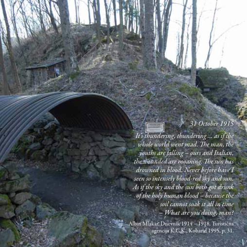
31 October 1915
It’s thundering, thundering … as if the whole world went mad. The man, the youths are falling – ours and Italian,
the wounded are moaning. The sun has drowned in blood. Never before have I
seen so intensely blood-red sky and sun. As if the sky and the sun both got drunk
of the holy human blood – because the soil cannot soak it all in time – What are you doing, man?
Albin Mlakar, Dnevnik 1914 – 1918, Turistična agencija K.C.K., Kobarid 1995, p. 31.

After the Italian occupation of Bovec in August 1915, the Austro-Hungar-ian Army further reinforced its first line of defence at the eastern rim of the Bovec basin, especially across two hills: Ravelnik (519 m) and Stržišče (486 m). The two elevations form a natural blockade which was changed by the Austro-Hungarian soldiers by means of fortified positions, caves and trenches to the pillar of their defence.
An outdoor museum is arranged on the slope of Mt. Ravelnik in the area of the onetime Austro-Hungarian first line of defence. A circular path connects the cleansed and restored
trenches and connection tunnels, pill-boxes, caves, machine-gun emplace-ments and reconstructed cabins. There are a lot of remains in this relatively small area.
Austro-Hungarian first line of defence in the Bovec area
Ravelnik

Access
About 1.5 km from Bovec, in the direction of Predel and the Trenta valley, there is a First World War military cemetery. From the ceme-tery you continue in the direction of Trenta another few hundreds of meters, where a trail branches to the right from the main road. After some minutes of walk you reach the information board, at which the circular path starts through the outdoor museum.
Altitude above sea level
Starting point: Bovec 460 m Museum: 519 m
Tour duration: 1 hour
Difficulty: Undemanding
GPS: 46.339725, 13.571506

zemljevidmuzeja
passage trench
�e Walk of Peace
info board
cave
cabin
shooting shield
observation post
shell hit
fortication with a loophole
3
1
2
4
5
6
7
military cemeteryBovecLog pod Mangartom
Kal-KoritnicaTrenta
050
m
N
1
11
2
2
2
3
3
4
5
67
7
Map Outdoor Museum Ravelnik

23 June 1916
Well, after I had shaved myself, I was also told that tomorrow would be Sunday; and I thought: let it be. Sunday? What do I profit from Sunday? Shall I possibly go to the
holy service? Shall I throw bowls or go to see my girl? Nothing. No, those times have all gone!
Albin Mlakar, Dnevnik 1914 – 1918, Turistična agencija K.C.K., Kobarid 1995, p. 86.

The outdoor museum Čelo represents gun fortification which was built by the Austro-Hungarian Army on the slope of Mt. Svinjak with an excel-lent view in the spring of 1915, just before the Italian–Austro-Hungarian encounter. The fortification was part of the Bovec blockade system (Sperre Flitsch) that played an important role in the defence of the valley part of the front line in the Bovec area.
The main part of the fortification consists of 200-metre long trench with masoned walls which connects two gun positions with a kitchen, an observation post,
two dormitories for 40 men, and a shelter for 20 soldiers. The trench had 150 crenels for riflemen. A beautiful view is offered on Čelo over the Bovec basin, Mt. Rombon and the other sur-rounding mountains.
Austro-Hungarian gun positions
Čelo

Access
From the village Kal-Koritnica, which lies at 3-km distance from Bovec in the direction of the Trenta valley, the access is possible from two directions, and throughout the tour you follow the marked path to Mt. Svinjak.
Altitude above sea level
Start: Kal-Koritnica 460 m Museum: 650 m
Tour duration: 2 hours
Difficulty: Undemanding
GPS: 46.341275, 13.584616

Kal-Koritnica
Kal-Koritnica
1
1
2 2
3
3
cave
gun position
dwelling place
1
2
3
info board
e Walk of Peace
Map Outdoor Museum Čelo

We were woken up by deep and heavy rumble in the Bovec basin and on the alp Zaprikraj. The pace of explosions was violent, booming. I asked Sassella to look at the watch: the hand showed two in the morning of 24 October 1917.Carlo Emilio Gadda, Beležka iz Kobarida, ZTT EST, Trst 2002, p. 38.

The outdoor museum Zaprikraj lies by the path between the alps Zaprikraj and Predolina above Drežnica. It represents the well fortified Italian first line of defence in the Krn range which blocked the passage along the valley between Mt. Krasji vrh and Mt. Vršič. The heaviest battles between the two adversary armies in the Krn range were fought in the autumn of 1915.
The museum's circular path runs through the trenches, caves, gun- and mortar positions, past the remains of cabins, a pillbox and the restored me-morial plaque dedicated to the killed Italian lieutenant.
Visit to the museum Zaprikraj is a whole-day tour which, in addition to revealing the history of the First World War, offers many pleasures of hiking in the unspoiled nature, where the alps are still active.
The Italian first line of defence
Zaprikraj

Access
At Kobarid you turn towards the village Drežnica (5 km) and continue to Drežniške Ravne (2 km). Further on, follow the way-signs for the alp Zaprikraj. At the trough, where the asphalt road ends, the macadam track starts. This is the starting point for the hiking tour to the outdoor museum Zaprikraj.
Altitude above sea level
Start: Drežniške Ravne 575 m Museum: 1259 m
Tour duration: 5–6 hours
Difficulty: Medium demanding
GPS: 46.293371, 13.613884

mortar position observation post
�e Walk of Peace
monument
info board
cave
pillbox
shell hit
dwelling places
1
2
4
5
3
trenches
2
5
2
2
2
5
3
24
3
2
5
2
N
0 50 m 100 m
1
Alp PredolinaGolobar
Alp ZaprikrajDrežnica
Map Outdoor Museum Zaprikraj
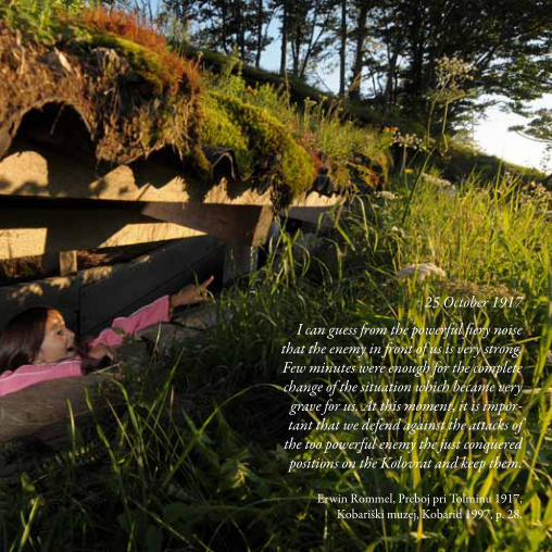
25 October 1917
I can guess from the powerful fiery noise that the enemy in front of us is very strong. Few minutes were enough for the complete change of the situation which became very
grave for us. At this moment, it is impor-tant that we defend against the attacks of
the too powerful enemy the just conquered positions on the Kolovrat and keep them.
Erwin Rommel, Preboj pri Tolminu 1917,
Kobariški muzej, Kobarid 1997, p. 28.

On the right bank of the Soča, between Kobarid and Tolmin, there rises a steep slope of the Kolovrat ridge from which a splendid view opens over the one-time Isonzo Front battlefield, stretch-ing from Mt. Kanin, the Krn range to Mt. Sveta Gora; the view on the other side stretches over the Veneto region and Friuli lowland all to the Adriatic. During the First World War the Italian Army built on the Kolovrat range an extensive system of the third line of defence, called “linea d’armata”, a part of which is now arranged as the outdoor museum. It presents commanders and observation posts, machine-gun and gun positions, caves and networks of trenches. A visit to these positions is of
special interest thanks to various details, such as spiral stairs in one of the caves, and also due to partly original materials which were used in the wartime. The outdoor museum Kolovrat is a trans-border museum which continues on the Italian side, too.
The Italian third line of defence
Kolovrat
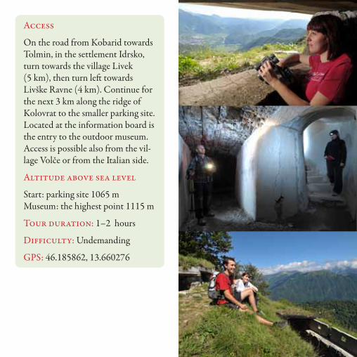
Access
On the road from Kobarid towards Tolmin, in the settlement Idrsko, turn towards the village Livek (5 km), then turn left towards Livške Ravne (4 km). Continue for the next 3 km along the ridge of Kolovrat to the smaller parking site. Located at the information board is the entry to the outdoor museum. Access is possible also from the vil-lage Volče or from the Italian side.
Altitude above sea level
Start: parking site 1065 m Museum: the highest point 1115 m
Tour duration: 1–2 hours
Difficulty: Undemanding
GPS: 46.185862, 13.660276

KobaridLivek
Volče
Solarje
Solarje
Mengore
2
1
N1
1
0 50 m 100 m
Trinški vrh
Na gradu Klabuk
1115m
1136m ITALIJA
SLOVENIJA
restored section of positions
a former border guardhouse of the Yugoslav army
e Walk of Peace
info board
1
2
trenches
vantage point
Map Outdoor Museum Kolovrat

However, man by the Soča got used to bearing everything. Cold, heat, dust, rock camps, water shortage, flies. He overcame fear of shells and air torpe-does, of bombs that fall from the sky, and of blasting mines which turn up ground, of daggers, hand grenades, booming fire. He got used to everything, almost to death. He only couldn’t get used to one thing – to Mrzli vrh.Alice Schalek, Posočje: marec do julij 1916, Karantanija, Ljubljana 2005, p. 261.

Above the valley of the Soča, on its left bank near Tolmin, the steep slope of Mt. Mrzli vrh (1359 m) rises. In the First World War, it figured as one of the key points in the Austro-Hungari-an defence of the Tolmin bridgehead.
The ridge of Mt. Mrzli vrh is densely crisscrossed by numerous trenches and caves of the two belligerent sides. Just below the top of the mountain, in its north-eastern slope, the Austro-Hungarian Army hollowed roomy caves. In one of them a concrete altar was erected by the Hungarian soldiers in 1917.
The remains of the Austro-Hungarian and Italian first lines of defence on Mt. Mrzli vrh are connected with a circular path which runs past two still active alps, Pretovč and Lapoč.
Austro-Hungarian and Italian first lines of defence
Mrzli vrh

Access
It is possible to reach the outdoor museum Mrzli vrh from several directions. The easiest access runs from the village Krn, but you can also start from the village Zatol-min. The path from the village Krn gradually ascends to the alp Pretovč (1.5 hrs walk). At the alp, the arranged circular path through the outdoor museum starts.
Altitude above sea level
Start: the village Krn 870 m Zatolmin 258 m the alp Pretovč 1142 m
Museum: the highest point 1359 m
Tour duration:
from the village Krn: 5–6 hours; from the village Zatolmin: 6–7 hours
Difficulty: Demanding
GPS: 46.217555, 13.696775
A beautiful view opens from Mt. Mrzli vrh over the onetime battlefield of the Isonzo Front.
Just below the top of Mt. Mrzli vrh there is a restored monument on the onetime Austro-Hungarian military cemetery.

monumentZatolmin
JavorcaTolmin
village Krn Kobarid
military chapel
�e Walk of Peace
info boardMap Outdoor Museum Mrzli vrh

Record of the order, found with an Italian P.O.W.:
“It is difficult to pick up a rose from Sveta Lucija, it is easy to be pricked by its thorns. But your brides, wives and
mothers want exactly this rose. Bring it to them, at any cost.”
Alice Schalek, Posočje: marec do julij 1916, Karantanija, Ljubljana 2005, p. 212.

Mengore hill, together with the two neighbouring hills, Cvetje and Bučenica, was the core of the Austro-Hungarian defence of the Tolmin bridgehead. The entire area was strongly fortified with numerous trenches and caves. All the time during the 29 months of the war, the Austro-Hungarian positions on Mengore hill were exposed to constant shelling by the Italian artillery from higher elevations on the right bank of the Soča. Neither side attained any big-ger success. It was exactly this area that served in the decisive 12th Isonzo Battle as the point of departure for the success-ful breakthrough of the joint Austro-Hungarian-German Army, which
pushed the Italian troops from the Upper Soča Region all to the river Piave. A circular path through the museum runs past well-preserved and restored remains of the Austro-Hungarian first line of defence.
Austro-Hungarian first line of defence at the Tolmin bridgehead
Mengore

Access
The pass of Poljance, which is the starting point for the visit to the outdoor museum Mengore, lies 2 km from Most na Soči in the direc-tion of Nova Gorica. The parking site is arranged on the pass and the information board is also there.
Altitude above sea level
Start: the pass of Poljance 253 m Museum: the highest point 453 m
Tour duration: 2–3 hours
Difficulty: Undemanding
GPS: 46.166621, 13.721516
It runs past trenches, caves, memorial tablets, remains of stone walls of cabins, a water reservoir and the monument of the onetime military cemetery. On the top of Mengore hill stands a church, dedicated to the Holy Virgin’s Name.

searchlight position
info board
gun position
howitzer position
pass point
water cistern
the IV/53 command
�e Walk of Peace
1
4
5
6
7
monument at the onetime cemetery
8
observation post
the church of the Holy Virgin's Name
abyss
troop's cave
9
11
12
the Kanduč memorial plaque13
the Pavelić memorial plaque14MODREJC E
TOLMIN
Cvetje
123
4
5
9
6
7
10
812
11
13
14
German Charnel House
2 103
123
4
56
7
8
9
10
11
13
14
12
military cemetery Modrejce
military cemetery Modrejce
Map Outdoor Museum Mengore

Worth seeing!The war still rages. Nevertheless, the
peace will eventually bless all the valleys, and the old heavenly tranquillity will
mercifully reign over the mountains. Then, we shall visit the graves and pay
homage to our dead heroes.Dr. Julius Kugy, Moja vojna v Julijcih, Edizioni
Saisera, Tavagnacco 2008, p. 139.
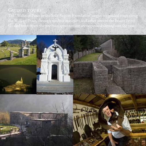
Guided toursThe “Walks of Peace in the Soča Region Foundation” organizes guided tours along the Walk of Peace, through outdoor museums and other sites of the Isonzo Front. Guided tours upon the previous appointment are organized throughout the year.

¶ The book : The Walk of Peace – A Guide along the Isonzo Front in the Upper Soča Region
¶ The thematic map: The Isonzo Front from Mt. Rombon to Mengore Hill
¶ The presentation DVD: The Walk of Peace in the Soča Region
Recommended ...

Dolina Soc e • The Soc a Valley
Published by The “Walks of Peace in the Soča Region Foundation”; Text: Tadej Koren; English translation: Branka Klemenc; Page layout: Matic Leban; Cartography: Mateja Sirk Fili; Photos: Tamino Petelinšek, Željko Cimprič, Tomaž Ovčak, Srdjan Živulovič – BOBO; Print: Dokumentarna d.o.o., Kobarid 2009.
… visit to the Kobarid Museum and the Tolmin Museum, the fortification Kluže, private museum collections and the exhibition The Walk of Peace in the Informa-tion Centre of the Walk of Peace Foundation.

InfoInformation CentreThe “Walks of Peace in the Soča Region Foundation” Gregorčičeva ul. 8 5222 KobaridSlovenia................................................ 00386 (0)5 389 01 67 00386 (0)5 389 01 68 www.potmiru.si [email protected]
Podprto s subvencijo Islandije, Lihtenštajna in Norveške preko Finančnega mehanizma EGP in Norveškega finančnega mehanizma.


