European Journal of Geography Volume 7, Number 3:86 - 98, September 2016
©Association of European Geographers
European Journal of Geography-ISSN 1792-1341 © All rights reserved 86
THE FORMATION AND MORPHOLOGICAL CHARACTERISTICS OF
ALLUVIAL FAN DEPOSITS IN THE RANGPO BASIN SIKKIM.
Saidur RAHAMAN Tarangahati High School, Department of Geography, Kolkata, India.
[email protected]
Abstract
The present paper focuses on some observations and distinct findings about the formation and
morphological characteristics of alluvial fans deposit in the Rangpo basin. Three alluvial fans
have been taken under the study. It is an ample scope for studying the evolution and
developmental strategies of alluvial fans being originated by both endogenetic and exogenetic
forces. The geometry of fans are mainly controlled by the relating factors like relief, climate,
lithology and the hydrographic characteristics of the streams. Fan development is a result of
complex interaction of climate and tectonism being influenced by open hydrological system.
It is observed from the study that the surface slope of the three coalesced fans being very
steep has been carved out into agricultural terraces which are cultivated on a regular basis.
Keywords: Exogenetic, Fan Head, Fan Boundary, Boulder, Terrace, Fan Surface.
1. INTRODUCTION
A fan shaped mass of sediment especially silt, sand, gravel, and boulders, deposited by a river
when its flow is suddenly slowed. It is a depositional landform of the lower course of the
river. The present paper point out about ‘The Formation and Morphological Characteristics of
Fan Deposits in the Rangpo Basin’. The detail study about the nature and development of
alluvial fans is concerned with the morphological arrangements and mode of occurrences
both in a quantitative as well as qualitative. The mountain streams are debouching out on a
flat plain, deposits its load, building up an alluvial fan. The geometry of fans is mainly
controlled by the relating factors like relief, slope, climate, parent material, lithology and the
hydrographic characteristics of the streams. It is an ample scope for studying the evolution
and developmental strategies of alluvial fans being originated by both endogenetic and
exogenetic forces.
There are several macro and micro fans have developed over the entire elongated
Himalayan foothills of Sikkim with spectacular land use development being influenced by
slope, water velocity, carried materials etc. The alluvial fan deposits are coarse grained
poorly sorted and immature sediments. Usually boulders and gravels predominate with
subordinate amounts of sand, silt and sometime clay. The size of materials is large and
process of soil formation is hampered by regular flood deposits. The developments of fans
are controlled by some integrated factors like: slope, climate, parent material, decrease of
velocity etc. The piedmont zone of the foothills is well marked by the development of alluvial
fans. This fan areas are also marked by variabilities of land use mainly agriculture is
developed over the fertile alluvial deposits on which soil layers have prominently developed.
European Journal of Geography Volume 7, Number 3:86 - 98, September 2016
©Association of European Geographers
European Journal of Geography-ISSN 1792-1341 © All rights reserved 87
The main objectives of this study are to identification the morphological characteristics of
the fans and to find out their spatiality variability. The study also analyzes the materials and
sizes of the fans. The present researcher tries to understand the uses of alluvial fans of that
region.
2. LOCATION
The Rangpo River is a right bank tributary to the Tista River at Rangpo town. It rises along
the ridge on the international boundary between India and China at an elevation of 15509 ft
of Nakchok Peak. Our area of field work is located somewhere in the immediate west of the
confluence point at an around (27°12’18”N and 88°38’37”E). In the study area the Rangpo
valley is wide open with a forest area along the left bank and a cultivated landscape around
the right bank. However the cultivated area is not continuous and it mainly covers the area
belonging to the alluvial fans and the river terraces.
3. METHODOLOGY
To fulfill the aforesaid objectives the present worker has adopted the modern methodology
including the Remote Sensing and GIS. Most of the analysis of the study is based on
intensive field work, data collection and empirical observations in terms of- (i) pre-field, (ii)
field and (iii) post field methods with an application of advanced techniques of measurement
and analysis. The first phase has been gone through an extensive literature survey to find out
the trend and observation of previous work and the secondary data and maps have been
collected from various sources. During the field survey different instrument like dumpy level,
prismatic compass, G.P.S., accessories like tape, hammer, etc. have been used. A detailed
G.P.S survey of alluvial fans was carried out during the field work. Such a survey determined
the location of the fans, their traversing, measurement of elevation etc. In the post field
session the data collected, is processed and fan profiles were constructed. Moreover, the co-
relation between different bi-variate set of data is worked out and equations formulated
graphical co-relation on the basis of such data has been done, through statistical method.
3.1. Literature Review
Denny (1965) showed normally the coarsest sediment will be found at the fanhead. When
there fanhead trenching occurs, there is reworking and flushing of the sediment further
downstream. Sometimes this results in a slight increase in the size of sediment along the fan
radius. According to Bull (1977) fan materials are classified by Mud flow, braided stream
flow and stream channel flow among which stream channel flow is responsible for the
development of alluvial fans over this area. Bull has graphically summarized his observations
on modern fans, and he has identified two situations. The first is when deposition is near the
mountain front and the fan surface is undissected, and the second is when deposition is
Hudson (1957) observed in Rhodesia that erosion increases exponentially with slope. Erosion
is more active on a steep slope. As the slope increases the type of erosion and mass
movement also change. For instance; vertical mass movement i.e. fall (rock fall, debris fall
etc.) and landslide are active on steep slope while creeping (soil creep, rock creep, talus creep
etc.) is dominated on moderate to gentle slope.at the toe of the fan and water and sediment
move to this location through a trench. Strahler (1969), States that low rates of erosion allow
the accumulation of thick weathering mantles which in progressively masking the underlying
bedrock, gradually free river channels from structural controls.
European Journal of Geography Volume 7, Number 3:86 - 98, September 2016
©Association of European Geographers
European Journal of Geography-ISSN 1792-1341 © All rights reserved 88
Anstey (1965) has made a detailed comparison of fans in the great basin of the western
United States, Baluchistan and Pakistan, and he demonstrates, from a sample of almost 2000
fans, that the greatest numbers of modern fans have radii between about 1 and 5 miles. Ryder
(1971) showed the variability of sediment size on the fan surface is also encountered at depth;
however, the overall vertical change in sediment size should be from finest at the base to
progressively coarser at the fan grows up and out from the Canyon mouth.
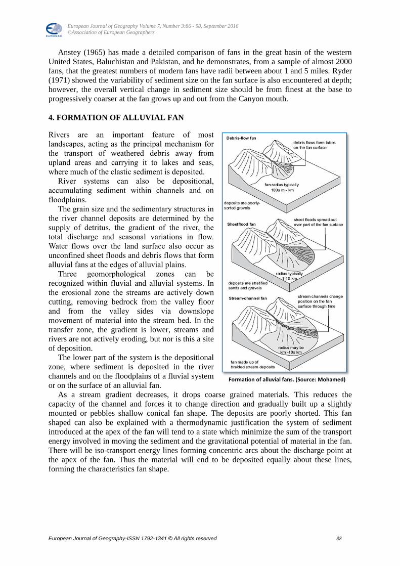
4. FORMATION OF ALLUVIAL FAN
Rivers are an important feature of most
landscapes, acting as the principal mechanism for
the transport of weathered debris away from
upland areas and carrying it to lakes and seas,
where much of the clastic sediment is deposited.
River systems can also be depositional,
accumulating sediment within channels and on
floodplains.
The grain size and the sedimentary structures in
the river channel deposits are determined by the
supply of detritus, the gradient of the river, the
total discharge and seasonal variations in flow.
Water flows over the land surface also occur as
unconfined sheet floods and debris flows that form
alluvial fans at the edges of alluvial plains.
Three geomorphological zones can be
recognized within fluvial and alluvial systems. In
the erosional zone the streams are actively down
cutting, removing bedrock from the valley floor
and from the valley sides via downslope
movement of material into the stream bed. In the
transfer zone, the gradient is lower, streams and
rivers are not actively eroding, but nor is this a site
of deposition.
The lower part of the system is the depositional
zone, where sediment is deposited in the river
channels and on the floodplains of a fluvial system
or on the surface of an alluvial fan.
As a stream gradient decreases, it drops coarse grained materials. This reduces the
capacity of the channel and forces it to change direction and gradually built up a slightly
mounted or pebbles shallow conical fan shape. The deposits are poorly shorted. This fan
shaped can also be explained with a thermodynamic justification the system of sediment
introduced at the apex of the fan will tend to a state which minimize the sum of the transport
energy involved in moving the sediment and the gravitational potential of material in the fan.
There will be iso-transport energy lines forming concentric arcs about the discharge point at
the apex of the fan. Thus the material will end to be deposited equally about these lines,
forming the characteristics fan shape.
Formation of alluvial fans. (Source: Mohamed)
European Journal of Geography Volume 7, Number 3:86 - 98, September 2016
©Association of European Geographers
European Journal of Geography-ISSN 1792-1341 © All rights reserved 89
5. LITHOLOGY OF THE STUDY AREA
The Rangpo basin crosses a number of lithological contacts. In the source area it is located
well within the central crystalline Gneissic complex of the Kanchenjunga group. This
formation is mainly confined to the north eastern corner and north western corner of the
district. This Kanchenjunga formation extends mainly over an area delineated by the
confluence of Rishi nala with Simana khola in the west, the lineament of Dhaula nala in the
south and the confluence of Kiring Chu in the east. The north western exposure is found
along the north western border of the district up to Rithu Khola region in the south.
The Daling group of rocks mainly consist of greenish Phyllites, Slates and Quartzitic mica
Schist‟s. The Daling group of rocks mainly represents an argillaceous sequence ranging in
age from Precambrian to Cambrian. Stratigraphically, the Daling groups of rocks are the
oldest group of the meta-sedimentary rocks deposited over the basement complex. This group
of rocks indicate very low grade of metamorphism. The basal part of the Daling group is
represented by the Gorubathan formation, comprising mainly Phyllites of argillaceous
composition and green Slates with Subordinate green Schist’s. The type area of this sub-
group is Gorubathan. At the contact zone between the Darjeeling group and Daling group a
mylonite Gneiss occurs. It covers for a length of about 1.5km. The Rongli Khola following
the alignment of a fault drains into the Rangpo within this mylonite zone. A few hundred
meters beyond the confluence towards west the Gorubathan formation. Here the river crosses
number of lithological contact. In such sections various types of schist occur along with the
phyllite. Our study concentrates on such a landscape where several litho contacts run across
the river through the main country rock belongs to the Gorubathan formation. The rock beds
in this area dip towards east at a range of 25° to 40°. However, a published map of G.S.I
titled as District Resource Map records a maximum of 45°.
6. DRAINAGE PATTERN
Complex and diverse drainage characteristics in the Rangpo Basin offer a fascinating study
for the evolution of landscape as well as land use pattern. Broadly, this river basin belongs to
the Brahmaputra Drainage System. Regionally the entire area is drained by number of
perennial rivers. The drainage system of the study area is controlled by the structure and neo-
tectonic activity within the polygenetic activity. The drainage pattern includes mainly
terraces, valleys, alluvial cones, truncated ridge-spurs, rectangular, braided, dendritic and
radial drainage pattern being sculptured by both endogenetic and exogenetic forces. These are
also supported by the peculiar modes of formation of the riverine topography primarily under
fluvial environment. The fluvial landforms as well as drainage channel patterns have
reflected several morphological characteristics being enabled with land use pattern.
7. CLIMATE AND NATURAL VEGETATION
Aritar (A town, located on the bank of Rangpo River and besides our study area) features a
monsoon-influenced subtropical highland climate. Because of its elevation and sheltered
environment, Aritar enjoys a mild, temperate climate all year round. Temperatures range
from an average maximum of 25°C in summer to an average minimum of 4°C in winter.
Summers (lasting from late April to June) are mild, with maximum temperatures rarely
crossing 25°C. The monsoon season from June to September is characterized by intense
torrential rains often causing landslides. Rainfall starts to rise from pre-monsoon in May, and
peaks during the monsoon, with July recording the highest monthly average of 649.6 mm
(25.6 inch).
European Journal of Geography Volume 7, Number 3:86 - 98, September 2016
©Association of European Geographers
European Journal of Geography-ISSN 1792-1341 © All rights reserved 90
The per-humid climate of the Rangpo basin in Sikkim is characterized with enormous
water surpluses. The prevalent monsoon climates have supported evergreen (broad leaf)
rainforests including grasses which become dense and luxuriant in some parts of the basin. It
is important to note that depending upon the terrain properties e.g. structure, rocks in
different geological formations, surface cover, and slope, the water surplus takes its course
either through surface run off or deep percolation to underground regions. Practically, per
humid climatic types are found in the whole mountainous terrain according to the moisture
regime which plays a decisive role in the water potentialities of various sectors within the
basin. Obviously, the southwest monsoon season which is the principle rainy period for
almost the entire Rangpo basin is responsible for more than 80% of the total annual rainfall in
these mountainous ecological sites, and significant in controlling the water balance.
8. ANALYSIS
Along the right bank slope of the Rangpo basin, a few alluvial fans have been formed.
Among them 3 alluvial fans are coalesced. These three fans have been attached with each
other through some overlapping section between 2 consecutive fans. In fact, these fans are
little different from normal morphology of alluvial fans. They have sufficient difference of
altitude between the fan head and fan rim or fan boundary. In that sense one may differ to call
them alluvial fan. Two other fans are having discrete location, i.e. they located further west-
ward. Interestingly the left bank of the river does not form any alluvial fan. The cause of
formation is mainly related to the throwing of sediments by the minor rivulets subsequent to
torrential rain. Sediment collected form upper ridges are thrown at the break of slope where
they develop very steep fan like landforms, which may not be true fans in all cases.
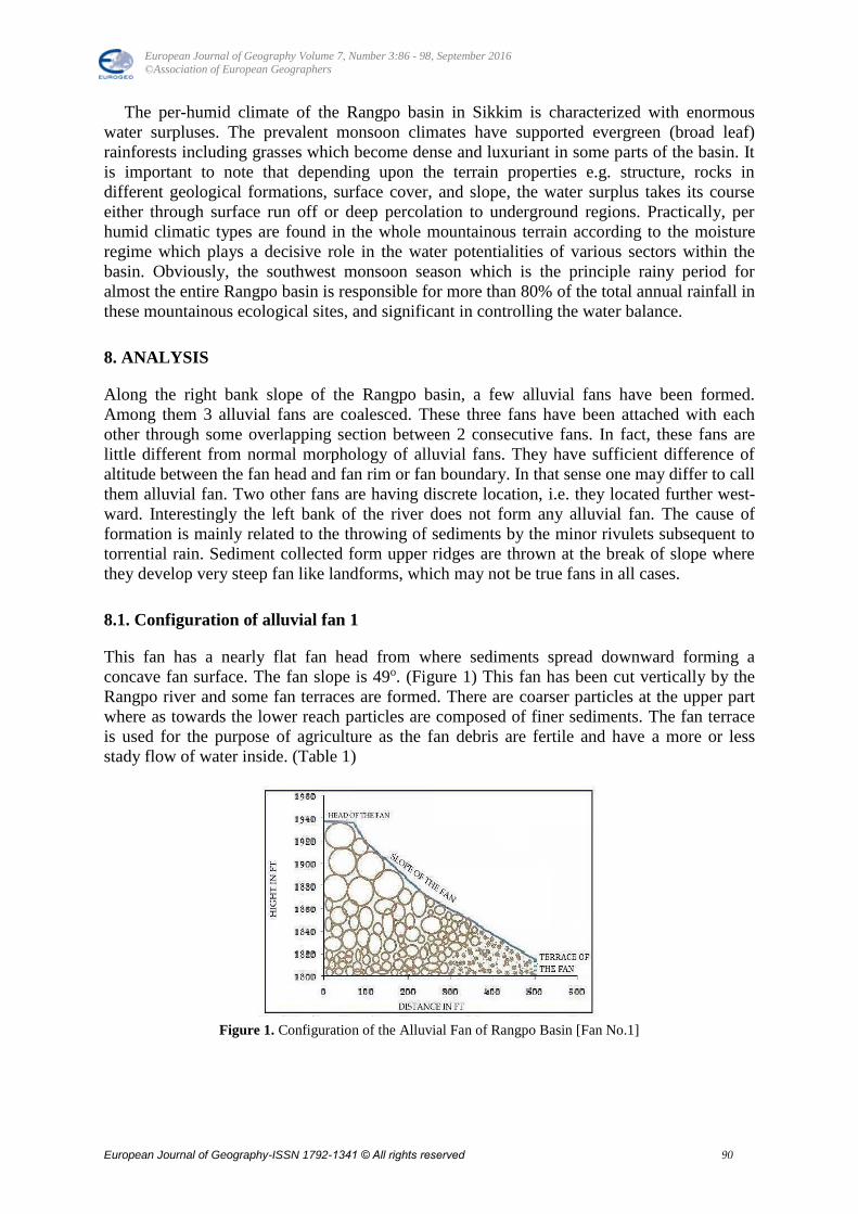
8.1. Configuration of alluvial fan 1
This fan has a nearly flat fan head from where sediments spread downward forming a
concave fan surface. The fan slope is 49o. (Figure 1) This fan has been cut vertically by the
Rangpo river and some fan terraces are formed. There are coarser particles at the upper part
where as towards the lower reach particles are composed of finer sediments. The fan terrace
is used for the purpose of agriculture as the fan debris are fertile and have a more or less
stady flow of water inside. (Table 1)
Figure 1. Configuration of the Alluvial Fan of Rangpo Basin [Fan No.1]
European Journal of Geography Volume 7, Number 3:86 - 98, September 2016
©Association of European Geographers
European Journal of Geography-ISSN 1792-1341 © All rights reserved 91
8.2. Configuration of alluvial fan 2
This fan head is very steep from where sediments spread downward forming a concave fan
surface. (Figure 2) This fan has been cut vertically by the Rangpo River and some fan
terraces are formed. The fan slope is 69o i.e. slope of the fan is very steep. At the lower part
of the fan has a relatively gentle slope where some sort of agricultural work is done. (Table 2)
Figure 2. Configuration of the Alluvial Fan of Rangpo Basin [Fan No.2]
Table 1. Showing height according to distance
data for fan 1.
Sl.no Distance in ft Diatance in
height
1 0 1937
2 70.6 1936
3 97.4 1919
4 164 1898
5 218 1879
6 243 1871
7 290 1861
8 350 1849
9 390 1839
10 420 1833
11 500 1815
Source : Field Work,2013
European Journal of Geography Volume 7, Number 3:86 - 98, September 2016
©Association of European Geographers
European Journal of Geography-ISSN 1792-1341 © All rights reserved 92
8.3. Configuration of alluvial fan 3
The fan surface of this is concave. (Figure 3) Fan head is very steep. The fan slope is 55o.
There are coarser particles at the upper part where as finer particles at the lower part. This fan
has been cut vertically by the Rangpo river and some fan terraces are formed. (Table 3)
Figure 3. Configuration of the Alluvial Fan of Rangpo Basin [Fan No.3]
Table 2. Showing height according to
distance data for fan 2.
Sl.no Distance in
ft
Diatance in
height
1 0 1985
2 75 1930
3 150 1877
4 199 1847
5 225 1836
6 265 1822
7 300 1814
8 353 1802
9 404 1799
10 525 1795
Source : Field Work,2013
European Journal of Geography Volume 7, Number 3:86 - 98, September 2016
©Association of European Geographers
European Journal of Geography-ISSN 1792-1341 © All rights reserved 93
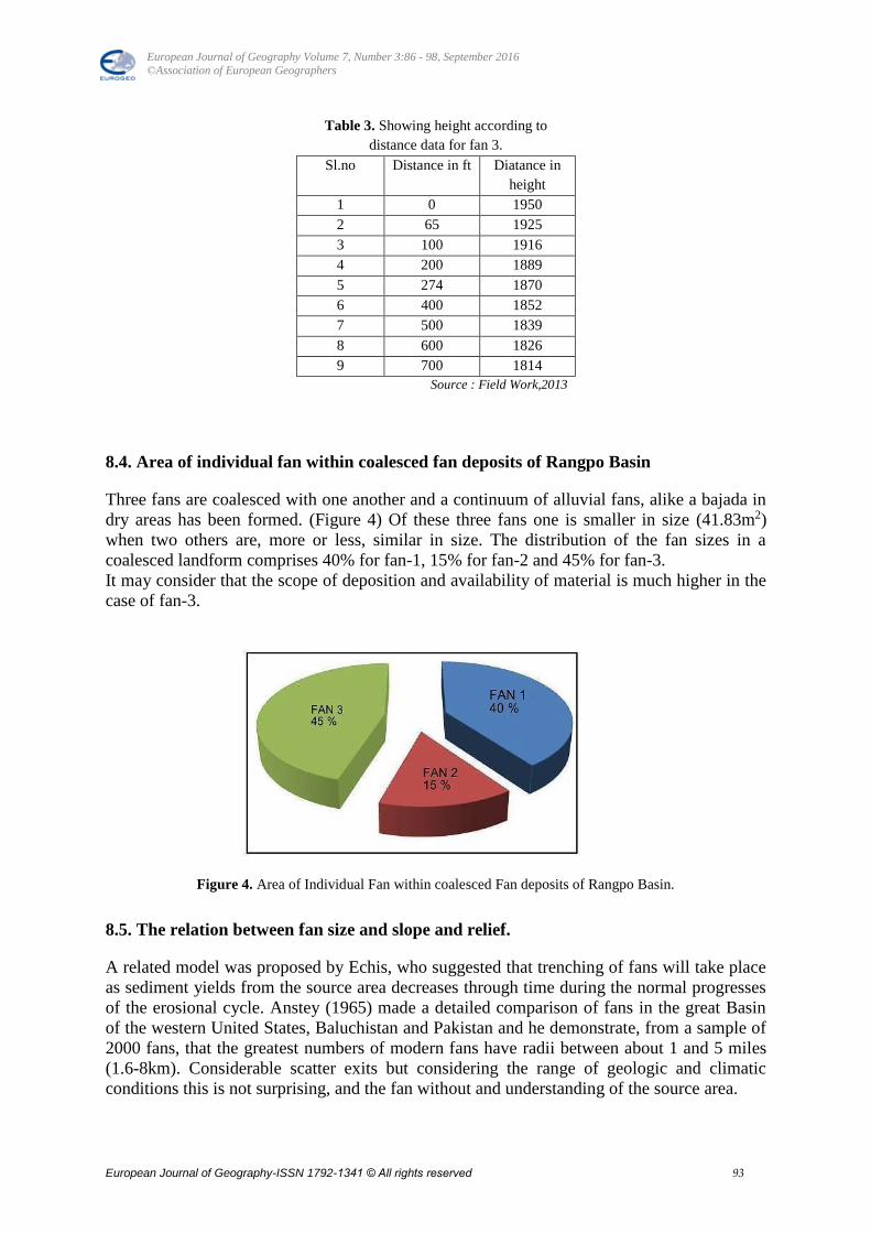
8.4. Area of individual fan within coalesced fan deposits of Rangpo Basin
Three fans are coalesced with one another and a continuum of alluvial fans, alike a bajada in
dry areas has been formed. (Figure 4) Of these three fans one is smaller in size (41.83m2)
when two others are, more or less, similar in size. The distribution of the fan sizes in a
coalesced landform comprises 40% for fan-1, 15% for fan-2 and 45% for fan-3.
It may consider that the scope of deposition and availability of material is much higher in the
case of fan-3.
Figure 4. Area of Individual Fan within coalesced Fan deposits of Rangpo Basin.
8.5. The relation between fan size and slope and relief.
A related model was proposed by Echis, who suggested that trenching of fans will take place
as sediment yields from the source area decreases through time during the normal progresses
of the erosional cycle. Anstey (1965) made a detailed comparison of fans in the great Basin
of the western United States, Baluchistan and Pakistan and he demonstrate, from a sample of
2000 fans, that the greatest numbers of modern fans have radii between about 1 and 5 miles
(1.6-8km). Considerable scatter exits but considering the range of geologic and climatic
conditions this is not surprising, and the fan without and understanding of the source area.
Table 3. Showing height according to
distance data for fan 3.
Sl.no Distance in ft Diatance in
height
1 0 1950
2 65 1925
3 100 1916
4 200 1889
5 274 1870
6 400 1852
7 500 1839
8 600 1826
9 700 1814
Source : Field Work,2013
European Journal of Geography Volume 7, Number 3:86 - 98, September 2016
©Association of European Geographers
European Journal of Geography-ISSN 1792-1341 © All rights reserved 94
Fan size should be significantly related to size of the sediment source area. An example of
this type of this relationship is provided Bull (1964) from the Fresno area, California. He
shows that a good relationship exists between fan area and drainage basins area and that
geology influences the relation, i.e. the intercept of the regression lines depending on
lithology.
8.6. Relationship between Relief & Slope
Usually relief & slope are directly proportional to each other, as slope is practically an
expression of relief. The same principal is observed in the alluvial fans of the Rangpo basin,
higher the relief between the fan head and fan boundary, the steeper the slope. (Figure 5)
When plotted on a graph with slope along the ordinate and relief along the abscissa a positive
co-relation is obtained in the case study of all the three alluvial fans, of the Rangpo basin.
Figure 5. Relationship between Relief & Slope.
8.7. Relationship between radii and size
A radius is the main control of the circumference of a circle. (Figure 6) As an alluvial fan
spreads from one center located at the fan head and the fan boundary forms an arc
proportional to the radius, there is a direct relation between the radii of the alluvial fans and
their sizes. (Table 4)
Figure 6. Relationship between Radii & Size.
European Journal of Geography Volume 7, Number 3:86 - 98, September 2016
©Association of European Geographers
European Journal of Geography-ISSN 1792-1341 © All rights reserved 95
The same principle is observed in the alluvial fans of the Rangpo basin. When plotted on a
graph with Radii along the ordinate and Size along the abscissa a positive co-relation is
obtained in the case study of all the three alluvial fans, of the Rangpo basin.
8.8. Fan structure.
Alluvial fan debris is poorly sorted due to the torrential deposition, especially near the fan
head. The extent and pattern of the coarser forces is governed by a balance between basins
size and relief, vegetation cover and hydrology and tectonic behavior of the mountain mass.
Normally the coarsest sediment will be found at the fan head. However, fan head trenching
occurs, there is reworking and flushing of the sediment further to the downstream. Sometimes
this result in the slight increased in the size of sediment along the fan radius (Denny 1965).
Shifting pattern of deposition on an alluvial fan will result in considerable sediment
variability. Lusting (1965) shows the distribution of reactive force on the antelope springs
fan, and the figure permits an appreciation of how sediments are distributed over a fan
surface at one stage in its growth. The variability of sediment size on the fan surface is also
encountered at depth, however, the overall vertical change in sediment size should be from
finest at the base to progressively coarser as the fan grows up but grain size should decrease
as erosion reduces the source area. Fan size should be significantly related to size of the
sediment source area.
Figure 7. Area and Distribution of materials in an Alluvial Fan.
Table 4. Showing data for relief, slope, radii and area of the
fans.
Name of
the Fan
Relief
[m]
slope[
degree]
Radii [m] Size /
Area[m2]
1 122 49 24.4 116.03
2 190 69 14.4 41.83
3 136 55 26 131.35
Source : Field Work,2013
European Journal of Geography Volume 7, Number 3:86 - 98, September 2016
©Association of European Geographers
European Journal of Geography-ISSN 1792-1341 © All rights reserved 96
The alluvial fan which is totally exposed on the surface without any vegetation cover, one of
the fans has been divided into four zones. (Figure 7) An average of 20 random samples of
particles has been collected from each zone and average diameter has been determined. Thus
we get four zones with four index diameters of the particles:
a) Large Boulder Zone: Diameter 25.5cm
b) Medium Boulder Zone: Diameter 13cm
c) Small Boulder Zone: Diameter 6cm
d) Gravel Zone: Diameter 1.8cm
Figure 8. Distribution of materials according to area [%] in an Alluvial Fan.
Considering the specialty of this zone within the alluvial fan, it has been observed that the
large boulder zone covers 10% of the area of the alluvial fan; medium boulder covers 13% of
the area; small boulder zone covers 50% of the fan area and lastly the gravel zone covers
27% of the fan surface. (Figure 8) Thus it may be concluded that maximum materials belong
to the small boulder zone. The large boulder being heavy are found only at the fan head,
whereas the small gravels are thrown at the most distant places of the fan head.
8.9. Controls of Fan Development
The development of fans are controlled by some integrated factors like:
(i) Climate: The climate of the region is characterized by the per-humid type of
climate with strong seasonal (June-October) distribution of rainfall. When precipitation is
high the slopes of the alluvial fan remain gentle as the flow of water shifts the sediments and
decreases the gradient. Actually, heavy rainfall increases the flow of water with huge amount
of sediments.
(ii) Lithology: The lithology of the rock character is another controlling factor for the
deposition of fans. The entire study area contained comparatively less coarse materials are
not so large, steep.
(iii) Hydrological Characteristics: large amounts of debris deposited on the alluvial
fans which are widely expand over the Himalayan foothills. On the fan surface the trunk
streams feds the distributary channels and water discharge diminishes along its course.
Moreover, as the fans consist of more permeable sediments, additional discharge is lost
European Journal of Geography Volume 7, Number 3:86 - 98, September 2016
©Association of European Geographers
European Journal of Geography-ISSN 1792-1341 © All rights reserved 97
because of downward water percolation (Mukhopadhyay, 1982). This discharge promotes the
rate of deposition.
(iv) Slope: Slope is another influencing factor for deposition of fans. The sudden
break of slope in the southern part helps to deposit the carried materials. But range of slope
decreases.
8.10. Use of alluvial fan
The alluvial fans which are old enough to develop soils on them and such materials have been
of great use for the local inhabitants. The surface slope of the three coalesced fans being very
steep has been carved out into agricultural terraces which are cultivated on a regular basis.
The alluvial fans having a good hydrological condition supply the required amount of water
which keeps the fan surfaces reasonably moist. Moreover the fan materials are lose and fine
because of a long period of weathering and associated soil forming process. Hence the local
inhabitants use the fans surfaces as readily usable cultivated fields. Thus the alluvial fans
have been a resource of high potentiality for the area.
9. CONCLUSION
The Rangpo basin having a great number of litho-units with variable resistance and high
relative relief has developed complex hydraulic characteristics where hydraulic drops and
hydraulic jumps are regular features. The large scale piedmont terraces with extensive flat
alluvial fan deposits are formed by the result of progressive flattening of the gradient of the
major tributaries of Rangpo River. From the study it is concluded that the developmental
strategies of alluvial fans being originated by both endogenetic and exogenetic forces. There
are several macro and micro fans have developed over the area with spectacular land use
development being influenced by slope, water velocity, carried materials etc. So far the
proper management of agriculture production needs sufficient irrigation system improving
the methods.
ACKNOWLEDGEMENTS
The researcher wishes to offer his indebtedness and gratefulness to his teacher and guide Dr.
Partha Basu, M.A, Ph.D., and Formerly Associated Professor, Department of Geography,
Bhairab Ganguly College who has supervised this work and provided his valuable
suggestions and continuous encouragement in this undertaking. I would also like to thank my
fellow friend Aditi Sharma who helped me at every stage of this paper.
REFERENCES:
Bull, W.B. 1977. The alluvial fan environment. Progress in Physical Geography: 1:
222–270.
Bull, W.B. 1991. Geomorphic Responses to Climatic Change. Oxford, Oxford University
Press.
Cotton, C. A. 1952. GEOMORPHOLOGY, An Introduction to the Study of Landforms. New
Zealand, Whitcombe And Tombs Limited, 197-201.
Goudie, A.S. 2004. Encyclopedia of Geomorphology. London, Routledge, 1: 15-19.
European Journal of Geography Volume 7, Number 3:86 - 98, September 2016
©Association of European Geographers
European Journal of Geography-ISSN 1792-1341 © All rights reserved 98
Kostaschuk, R.A., MacDonald, G.M., and Putnam, P.E. 1986. Depositional processes and
alluvial fan – drainage basin morphometric relationships near Banff, Alberta, Canada,
Earth Surface Processes and Landforms: 11: 471–484.
Mohamed, K.R. Sedimentology and Stratigraphy (2nd edition), Wiley Blackwell.
Mukhopadhaya, S.C. 1978. Studies of intra-valley variation in weathering index, erosional
potential and terraces within Tista-Jaldhaka basins. Eastern India, Indian Journal of
Landscape System and Ecological studies. ILEE, Calcutta: 1: 10-67.
Mukhopadhyay, S.C. 1982. The Tista Basin – A Study in Fluvial Geomorphology. Kolkata &
New Delhi, K.P. Bagchi & Co.: 134-161.
Ryder, J.N. 1971. The stratigraphy and morphology of periglacial alluvial fans in south
central British Columbia. Canadian Journal of Earth Sciences: 8: 279–298.
Strahlar, A.N. 1974. Quantitative geomorphology of Basins and Channel network: Handbook
of Applied Hydrology. New York, McGraw-Hill Book Company: 17-26.
Strahler, A.N. 1969. Physical geography 3rd edition. New York, Wiley.
Wohl, E. 2005. Downstream Hydraulic Geometry along a Tropical Mountain River.
Springer, Netherlands: 169-188.