Current Research (2002) Newfoundland Department of Mines and Energy Geological Survey, Report 02-1, pages 245-264 THE GEOLOGICAL SETTING, GEOCHEMISTRY AND AGE OF LATE PROTEROZOIC INTRUSIVE ROCKS AT THE BUTLERS POND Cu–Au PROSPECT (NTS 1N/3), AVALON PENINSULA, NEWFOUNDLAND B.A. Sparkes, S.J. O'Brien 1 , M.R. Wilson and G.R. Dunning Department of Earth Sciences, Memorial University of Newfoundland, St. John's, Newfoundland, A1B 3X5 ABSTRACT The Butlers Pond Prospect, located in the central Avalon Peninsula of southeast Newfoundland, has been the focus of intermittent exploration activity for intrusive-hosted, copper–gold mineralization since its discovery in the early 1990s. This interest stems from the occurrence, around Butlers Pond, of outcrops of iron oxide-rich magmatic breccias, hydrothermally altered granite and volcanic rocks, and glacially derived boulders of copper–gold-bearing granites, intrusion breccia, and volcanic rocks. This mineralization has been characterized previously in terms of differing models of both "classic" porphyry copper–gold and iron oxide copper–gold (cf. "Olympic Dam") styles of mineralization. The property lies near an east–west embayment in the Holyrood Horst, and is underlain primarily by late Neoproterozoic (ca. 630 to 620 Ma) volcano-plutonic rocks, part of the Avalonian belt of the Newfoundland Appalachians. The oldest rocks outcropping on the property are pre-620 Ma flows and volcaniclastic rocks of the Harbour Main Group. These felsic to mafic, primarily subaerial units are intruded by three phases of the 625 to 620 Ma Holyrood Intrusive Suite, including the metallo- genically significant 622 ± 2 Ma Butlers Pond porphyry. The 620 Ma and earlier magmatic rocks are overlain by coarse- to fine-grained marine siliciclastic rocks, which may be correlated with either post-570 Ma sedimentary facies of the Concep- tion Group found east of the Topsail Fault, or older rocks of similar facies that occur as outliers elsewhere in the Holyrood Horst. The marine sedimentary rocks are intruded by a small pluton of diorite and gabbro, related to the Whalesback Gab- bro. The restricted areal extent of hematite-rich brecciation, the negative geochemical signatures (i.e., low U, Cu, Au, Ag and REE's) of the iron-oxide breccia in the Butlers Pond porphyry, and the nature and mineralogy of host intrusions, coupled with known geophysical signatures, argue against origins tied to a larger iron oxide Cu–Au system. The potassic alteration and the style of copper–gold mineralization in the granite breccia boulders at Butlers Pond are most consistent with an origin tied to a porphyry copper–gold style, magmatic hydrothermal system. Discrete zones of phyllic (silica–sericite–pyrite) alteration observed in outcrop (and in boulders) are also consistent with this style of mineralization, as is the geochemical signature of the associated intrusions. Existing evidence points to the mineralized and brecciated boulders being of local origin. The protolith of the copper–gold mineralized breccia, which is indistinguishable from equigranular phases of the Holy- rood Intrusive Suite widely developed north of the Butlers Pond region, coupled with the new 622 ± 2 Ma age of the Butlers Pond porphyry, further highlights the potential for mineralization elsewhere in the largely coeval Holyrood Intrusive Suite. These new data, however, confirm that this plutonism cannot be directly related to formation of the 580 to 570 Ma magmatic arcs hosting the extensive late Proterozoic high- and low-sulphidation Avalonian epithermal systems in the Hickey’s Pond, Hope Brook and Manuels areas of southern and eastern Newfoundland. 245 1 Regional Geology
Transcript
Current Research (2002) Newfoundland Department of Mines and EnergyGeological Survey, Report 02-1, pages 245-264
THE GEOLOGICAL SETTING, GEOCHEMISTRY AND AGE OFLATE PROTEROZOIC INTRUSIVE ROCKS AT THE
B.A. Sparkes, S.J. O'Brien1, M.R. Wilson and G.R. DunningDepartment of Earth Sciences, Memorial University of Newfoundland,
St. John's, Newfoundland, A1B 3X5
ABSTRACT
The Butlers Pond Prospect, located in the central Avalon Peninsula of southeast Newfoundland, has been the focus ofintermittent exploration activity for intrusive-hosted, copper–gold mineralization since its discovery in the early 1990s. Thisinterest stems from the occurrence, around Butlers Pond, of outcrops of iron oxide-rich magmatic breccias, hydrothermallyaltered granite and volcanic rocks, and glacially derived boulders of copper–gold-bearing granites, intrusion breccia, andvolcanic rocks. This mineralization has been characterized previously in terms of differing models of both "classic" porphyrycopper–gold and iron oxide copper–gold (cf. "Olympic Dam") styles of mineralization.
The property lies near an east–west embayment in the Holyrood Horst, and is underlain primarily by late Neoproterozoic(ca. 630 to 620 Ma) volcano-plutonic rocks, part of the Avalonian belt of the Newfoundland Appalachians. The oldest rocksoutcropping on the property are pre-620 Ma flows and volcaniclastic rocks of the Harbour Main Group. These felsic to mafic,primarily subaerial units are intruded by three phases of the 625 to 620 Ma Holyrood Intrusive Suite, including the metallo-genically significant 622 ± 2 Ma Butlers Pond porphyry. The 620 Ma and earlier magmatic rocks are overlain by coarse- tofine-grained marine siliciclastic rocks, which may be correlated with either post-570 Ma sedimentary facies of the Concep-tion Group found east of the Topsail Fault, or older rocks of similar facies that occur as outliers elsewhere in the HolyroodHorst. The marine sedimentary rocks are intruded by a small pluton of diorite and gabbro, related to the Whalesback Gab-bro.
The restricted areal extent of hematite-rich brecciation, the negative geochemical signatures (i.e., low U, Cu, Au, Ag andREE's) of the iron-oxide breccia in the Butlers Pond porphyry, and the nature and mineralogy of host intrusions, coupled withknown geophysical signatures, argue against origins tied to a larger iron oxide Cu–Au system. The potassic alteration and thestyle of copper–gold mineralization in the granite breccia boulders at Butlers Pond are most consistent with an origin tied toa porphyry copper–gold style, magmatic hydrothermal system. Discrete zones of phyllic (silica–sericite–pyrite) alterationobserved in outcrop (and in boulders) are also consistent with this style of mineralization, as is the geochemical signature ofthe associated intrusions. Existing evidence points to the mineralized and brecciated boulders being of local origin.
The protolith of the copper–gold mineralized breccia, which is indistinguishable from equigranular phases of the Holy-rood Intrusive Suite widely developed north of the Butlers Pond region, coupled with the new 622 ± 2 Ma age of the ButlersPond porphyry, further highlights the potential for mineralization elsewhere in the largely coeval Holyrood Intrusive Suite.These new data, however, confirm that this plutonism cannot be directly related to formation of the 580 to 570 Ma magmaticarcs hosting the extensive late Proterozoic high- and low-sulphidation Avalonian epithermal systems in the Hickey’s Pond,Hope Brook and Manuels areas of southern and eastern Newfoundland.
245
1 Regional Geology
CURRENT RESEARCH, REPORT 02-1
INTRODUCTION
The Butlers Pond Prospect is located in late Proterozoicrocks of the Newfoundland Avalon Zone, approximately 45km south–southwest of St. John's (Figure 1). The areaaround Butlers Pond (NTS map area 1N/3) has been thefocus of intermittent exploration for gold and base metalsfollowing the discovery of copper- and gold-rich, hydrother-mally brecciated granite boulders in the early-mid 1990s.The most recent activity in the area has focussed on gran-ite-hosted, hematite-rich breccias that outcrop at ButlersPond and the possibility of the area's potential to host iron-oxide–copper–gold (“Olympic Dam”) style of mineraliza-tion.
Although a significant amount of exploration has beenconducted to evaluate the property, the nature of mineraliza-tion, as well as its local and regional geological setting, haveremained largely equivocal. This study was undertaken toaddress these issues, in order to establish regional correla-tions with magmatic rocks and intrusion-related gold sys-tems elsewhere in the Avalonian belt, and in doing so, iden-tify prospective areas for similar mineralization in otherparts of the region. A limited amount of major-, trace- andrare-earth-element geochemistry on representative samplesuites was carried out in an attempt to classify mineralizedand brecciated rocks, and to test if various intrusive rocks inthe Butlers Pond area (including mineralized units) aregenetically linked to each other and/or to other, more exten-sive phases mapped elsewhere in the Holyrood IntrusiveSuite. The U–Pb dating of the Butlers Pond porphyry wascarried out to test its possible links with other dated parts ofthis suite.
The following account is based primarily on work con-ducted by the senior author as a B.Sc. (Honours) thesis(Sparkes, 2001 2), based on mapping carried out during alarger mapping and metallogeny project on the AvalonPeninsula, undertaken by the Geological Survey of New-foundland and Labrador. The following report summarizesdata presented in Sparkes (op. cit.) and also incorporates theresults of work carried out by the authors, independent ofthat thesis, as part of the Geological Survey's larger scaleinvestigations in the Proterozoic rocks of the central AvalonPeninsula.
PREVIOUS INVESTIGATIONS
The region north and east of Butlers Pond was includedin 1:250 000 systematic bedrock mapping surveys carried
out by McCartney (1967) and Rose (1952); rocks south ofthe area were mapped at the same scale by Williams andKing (1979). The first detailed mapping of rocks at ButlersPond was carried out during a survey of the east half of theSt. Catherine's map area by Mullins (1970); systematic map-ping of the entire region at 1:50 000 has been carried out byO'Brien et al. (1997, 2001a).
Chalcopyrite-bearing granite boulders exhibiting exten-sive brecciation and hydrothermal alteration were discov-ered at Butlers Pond by Cape Broyle Exploration Limited in1992. These returned assays as high as 6% Cu, 12.8 g/t Auand 0.23 oz/t Ag (Crocker and Dalton, 1994). Mineralizedmafic and felsic volcanic boulders containing up to 4.2%Cu, 376 ppb Au and 2.5 oz/t Ag were also discovered at thistime, in an area approximately 400 m west of the mineral-ized granite boulders. Both the granite and volcanic boul-ders were interpreted to be of local origin. Mafic volcanicrocks about 500 m west of Butlers Pond were subsequentlyfound to contain stringer-type chalcopyrite and chalcocite.Grab samples returned values of up to 1.06% Cu, 7.81 g/tAu and 7.9 g/t Ag (Crocker and Dalton, op. cit.).
Subsequent exploration from 1994 to 1995 by AvalonMines Limited included prospecting, line cutting, geologicalmapping, soil geochemistry, ground geophysics (VLF-EM,magnetics and time-domain IP) and seven diamond-drillholes, totalling 1002 m (Pickett, 1995, 1996). Diamonddrilling of geophysical targets did not identify the bedrocksource of the high-grade copper–gold-bearing boulders. TheButlers Pond property has been held by Altius Minerals Cor-poration from 1999. Much of the area of granitic rocks in thearea to the north of Mobile Big Pond (ca. 3 km north of But-lers Pond) has been recently (post-1999) explored by PhelpsDodge Corporation.
REGIONAL SETTING
The Butlers Pond Prospect lies within a complexassemblage of late Neoproterozoic, mainly subaerial vol-canic and plutonic rocks, traditionally assigned to the Har-bour Main Group and Holyrood Intrusive Suite, near theeast side of a broad, north–south elongated periclinal dome,known as the Holyrood Horst (e.g., McCartney, 1967, 1969;King, 1988; Figure 1). Recent mapping and geochronologi-cal studies of this part of the Appalachian Avalon Zone havedocumented a geological record of protracted and episodicvolcanicity, having varied composition, lithofacies, anddepositional environments, spanning a period of almost 160million years in the Neoproterozoic (O'Brien et al., 2001a).
246
2 The reader is referred to Sparkes (2001) for more detailed presentations and discussions of petrography, mineralogyand geochemistry from the Butlers Pond area, as well as a more comprehensive review of previous exploration.
B.A. SPARKES, S.J. O’BRIEN, M.R. WILSON AND G.R. DUNNING
Deposition of disparate volcanic successions was punctuat-ed by both marine and terrestrial sedimentation, and by theemplacement, uplift and erosion of intrusive suites of wide-ly differing age and composition.
The Harbour Main Group as delineated by McCartney(1967) includes rocks now known to be as old as 730 Ma
(Israel, 1998) and as young as approximately 580 Ma(O'Brien et al., 2001a, b). These compositionally diversevolcanic rocks include subaerial felsic ash-flow tuffs,coarse-grained, red siliciclastics, andesites, rhyolite to rhyo-dacite dome complexes, and less extensive (and in somecases, significantly younger), shallow-marine mafic flowsand pyroclastic rocks. The Holyrood Intrusive Suite repre-
247
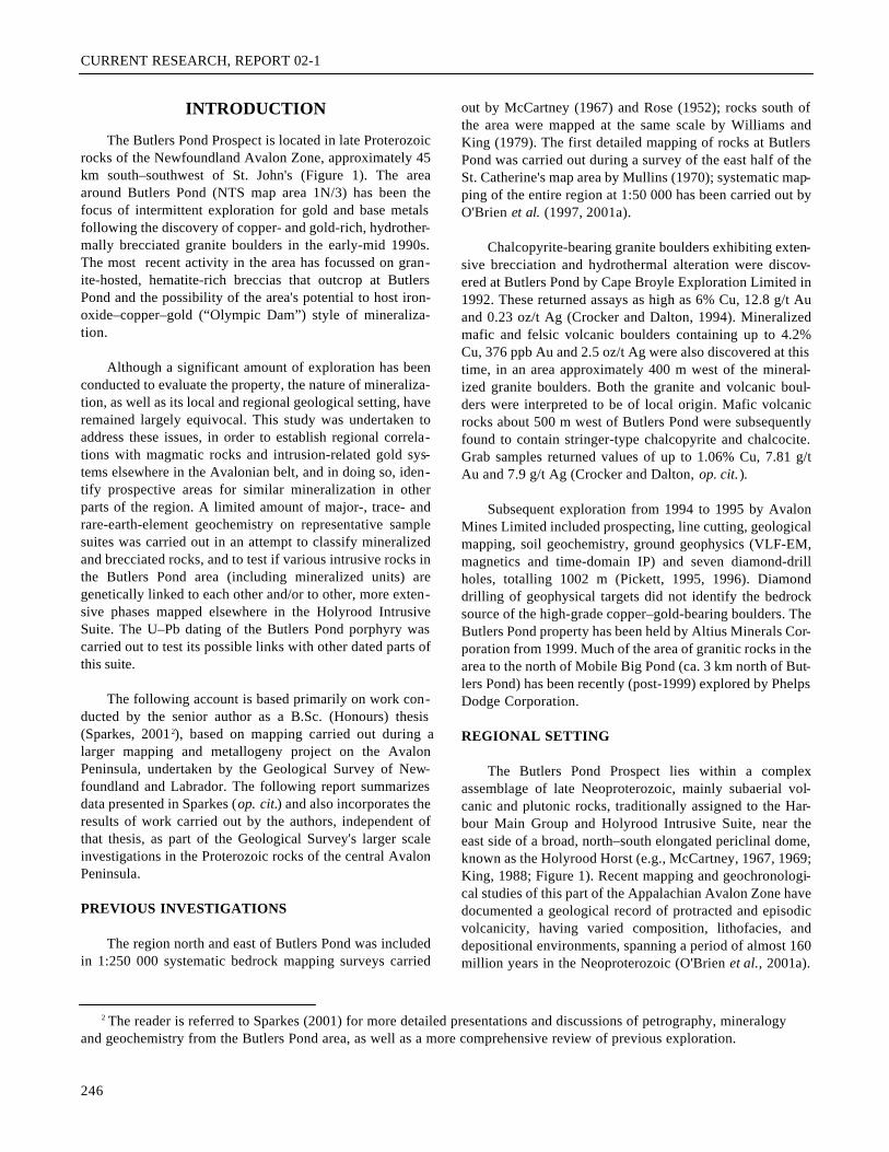
Figure 1. Generalized geology of theAvalon Peninsula and the HolyroodHorst, Newfoundland, showing loca-tion of Butlers Pond Prospect andother mineral occurrences (H=Hawke Hills Tuff, M=Manuels Vol-canic Suite, W=Wych Hazel PondComplex, C=Country Pond rhyolite;from O'Brien et al., 2001a).
CURRENT RESEARCH, REPORT 02-1
sents several spatially and lithologically separate, and inpart, genetically unrelated plutons. Quartz-rich, horn-blende–biotite granite forms the largest pluton that extendsfrom Conception Bay southward to the Butlers Pond area.This batholith-scale exposure of the Holyrood IntrusiveSuite has been dated at 620 ± 2 Ma (Krogh et al., 1988) and622 ± 3 Ma (see O'Brien et al., 2001a). Other plutons,including significantly younger Neoproterozoic granite,together with a variety of variably altered and mineralizedgranite, diorite, quartz–feldspar porphyry and hybrid rockshave been mapped along the eastern side of the HolyroodHorst, near Manuels, and southward into the area northeastof Mobile Big Pond (O'Brien et al., 1997, 2001a). Outliersof marine siliciclastic sedimentary rocks, historicallyassigned to the Conception Group (e.g., McCartney, 1967;King, 1988), but of at least two potentially separate ages,overlie volcanic and plutonic rocks within and adjacent tothe Holyrood Horst.
GEOLOGY OF THE BUTLERSPOND REGION
Rocks in the area surrounding Butlers Pond, as far northas Mobile Big Pond, are assigned here to seven map units,all of which are of either known or presumed Neoprotero-zoic age (Figure 2). The plutonic rocks, which belong to theHolyrood Intrusive Suite, are divided into three map units:i) granite typical of the quartz-rich (625 Ma to 620 Ma) mainphase of the Holyrood Intrusive Suite (O'Brien et al., 1997,2001a), ii) a porphyritic granite pluton, locally dated at 622± 2 Ma (see below Age of the Butlers Pond Porphyry), andiii) smaller, coeval intrusions of granodioritic to tonaliticcomposition. The last two units (ii and iii) are herein infor-mally named the Butlers Pond porphyry. Each of the threeunits intrudes primarily subaerial and locally shallow-marine volcanic rocks of the unseparated Harbour MainGroup (cf. McCartney, 1967), having an age greater than orequal to 620 Ma. Marine siliciclastic sedimentary rocks ofthe Conception Group in this area contain a unit of boulder-to-pebble polylithic conglomerate at the base, and are inter-preted to disconformably overlie both the Harbour MainGroup and Holyrood Intrusive Suite. The youngest rocks inthe map area are mafic to intermediate plutonic rocks of theWhalesback Gabbro, which are intrusive into the Concep-tion Group.
HARBOUR MAIN GROUP (UNITS 1 AND 2)
The oldest rocks in the map area are volcanic flows andvolcaniclastic rocks belonging to the Harbour Main Group,as outlined by McCartney (1967) and King (1988). Theserocks are divided into lithologically distinctive units of pri-marily felsic to intermediate and, to a lesser degree, mafic
composition. All are intruded by the Holyrood IntrusiveSuite.
Felsic to Intermediate Flows and Tuffs(Subunits 1a and 1b)
Unit 1 is divided into two principle lithofacies. The firstconsists of grey–green flows and fine-grained tuffs of rhyo-dacitic to dacitic composition that are depicted as subunit 1aon the accompanying map (Figure 2). The second, shown assubunit 1b on Figure 2, is a more homogeneous unit charac-terized by red–purple to grey, crystal-lithic tuff.
Grey–Green Rhyodacite–Dacite Flows and Tuffs(Subunit 1a)
The rocks of subunit 1a outcrop in the north-central partof the area south of Mobile Big Pond (Figure 2), and insmaller areas north and south of the eastern end of ButlersPond, where they have been intruded to the east and west bythe main granite phase of the Holyrood Intrusive Suite andboth phases of the Butlers Pond porphyry. The rhyo-dacite–dacite unit is grey- to white-weathering, grey–greenand locally purple on fresh surfaces, plagioclase-crystal-rich, and variably flow-banded. Along intrusive contactswith adjacent granite, the rhyodacite–dacite has been recrys-tallized to a dark grey to black hornfels, having a hacklycleavage. The crystal-rich rhyodacite–dacite exposed in asyncline southeast of Butlers Pond has a well-definedeutaxitic foliation and contains coarse-grained (#15 cm)lithic fragments. These locally display primary flattening,and have length-to-width ratios that vary from approximate-ly 5:1 to15:1.
Dyke-like bodies of granite intrude the rhyodacite–dacite unit parallel to and across subvertical flow-banding.Metre-scale blocks and rafts of thermally metamorphosedrhyodacite–dacite are common within each of the intrusions,particularly near their contacts.
Red–purple to Grey, Crystal-lithic Tuff (Subunit 1b)
The tuff of subunit 1b is well exposed in the west partof the study area and along the western and northwesternshores of Butlers Pond. On a regional scale, these tuffs formpart of the 630 to 620 Ma red-to-grey crystal-rich facies ofthe much more extensive Hawke Hills Tuff, which is wellexposed north and west of the study area (O'Brien et al.,2001a; G. Dunning, unpublished data). Subunit 1b is intrud-ed by all three phases of the Holyrood Intrusive Suite.
The tuff weathers pale pink to white, and is distinctlyred–purple on fresh surfaces. It is characteristically crystal-
248
B.A. SPARKES, S.J. O’BRIEN, M.R. WILSON AND G.R. DUNNING
rich (K-feldspar and plagioclase) and contains lithic frag-ments and pumice, flattened parallel to a variably developedand variably orientated eutaxitic foliation (length-to-widthratios from 2:1 to 7:1). Adjacent to the Butlers Pond por-phyry, tuffs of this unit are deformed by narrow, subvertical,generally north-trending shear zones. These rocks typicallylack pervasive hydrothermal alteration, although crosscut-ting, millimetre-scale chlorite and sericite veinlets are local-ly developed. One exception is the tuffs exposed on a high
hill immediately north of Butlers Pond, where discontinu-ous, one-metre-scale zones of silica–pyrite alteration aredeveloped very locally.
Mafic Flows and Pyroclastic Rocks(Subunits 2a and 2b)
Mafic volcanic rocks (Unit 2) are exposed in the southof the study area, where they are in assumed depositional
249
Figure 2. Geology of the area around Butlers Pond (after Sparkes, 2001).
CURRENT RESEARCH, REPORT 02-1
contact above Unit 1 felsic to intermediate volcanic rocks.The contact of Units 1 and 2 is presumed to be conformable.Coarsely vesicular, hematite-rich basalts (subunit 2a) out-crop adjacent to Butlers Pond, where they have been intrud-ed by the granite phase of the Butlers Pond porphyry. A sep-arate area of mafic rocks, which includes an areally-restrict-ed unit of pillowed mafic flows, are preserved in the south-western-most part of the map area (subunit 2a).
Hematite-rich Vesicular Flows (Subunit 2a)
The basalt of subunit 2a weathers pale grey and is grey-green and locally purple on fresh surfaces. It is typicallycoarsely vesicular, and contains amygdales (#1 cm) filledwith epidote, chlorite, quartz and calcite. Massive or non-vesicular flows are less extensive. The coarse-grainedamygdaloidal basalt contains macroscopic, plagioclase lathsin the groundmass, forming an ophitic texture. The basaltscontain abundant crosscutting veinlets and fractures, con-taining epidote with or without hematite. The vesicularbasalt intersected in diamond drilling by Avalon Mines nearButlers Pond in 1995 includes dark grey to red–purple, fine-to medium-grained, and ophitic-textured units, locally richin amygdales (#2 cm) filled by calcite and/or quartz, K-feldspar and epidote, and containing lesser amounts of chlo-rite and hematite. Zones of hematite-rich basalt are commonin drill core and have a distinctive red colouration.
The basalt contains widespread hematite and locallyepidote alteration near intrusive contacts with granite phaseof the Butlers Pond porphyry at Butlers Pond. The hematiteand epidote occur as millimetre-scale veinlets, as vesiclefillings and locally as a pervasive groundmass phase. Thealtered mafic rocks contain sulphide mineralization and,locally, significant copper and gold values (see belowDescription of the Mineralized Rocks).
Massive to Pillowed Flows (Subunit 2b)
In the southwest corner of the study area, the basaltflows of subunit 2b are pillowed and contain abundant, fine-grained, thinly layered yellow-green siltstone as inter-pillowmaterial. The pillows have coarsely vesicular cores and fine-grained, chilled rims; individual pillows range from 10 cmto 1.5 m in width. Filled vesicles contain epidote, chlorite,quartz and calcite.
Exposures of pillow basalt within the Holyrood Horstare uncommon. An areally restricted pillow basalt unit over-lies crystal tuff of the Hawke Hills Tuff near the Bosun, nearthe Inside Hawke Hills (NTS map area 1N/6), where it isoverlain by a thin pebble conglomerate unit at the base ofthe Conception Group.
HOLYROOD INTRUSIVE SUITE (UNITS 3 to 5)
All felsic to intermediate intrusive rocks in the ButlersPond area are asssigned to the Holyrood Intrusive Suite, alarge, compositionally and texturally composite, primarilyfelsic plutonic unit, characterized by an abundance ofquartz-rich, hornblende–biotite granite (O'Brien et al.,1997). The latter lithology represents one of three intrusivephases mapped within the exposures of the suite betweenButlers Pond and Mobile Big Pond. The remaining twointrusive units represent a hybrid, high-level stock, herereferred to informally as the Butlers Pond porphyry. The ageof the most extensive granite phase of the suite has beendetermined elsewhere at 620 ± 2 Ma (Krogh et al., 1988)and 623 ± 3 Ma (see O'Brien et al., 2001a). New data, pre-sented below, indicate that the Butlers Pond porphyry iscoeval with the extensively developed granite (Unit 3).
Medium- to Coarse-grained, Hornblende–BiotiteGranite (Unit 3)
The most widespread plutonic rock in the study area ishornblende–biotite granite (Unit 3) that is typical of much ofthe Holyrood Intrusive Suite exposed between Mobile BigPond and the Trans-Canada Highway (Route 1) (O'Brien etal., 2001a; see Figure 1). Unit 3 is exposed in the area northof Butlers Pond and extends to Mobile Big Pond and east-ward to the Topsail Fault zone, east of the map area. Thegranite clearly intrudes and contains numerous rafts of sub-unit 1a volcanic rocks near Mobile Big Pond. Variably ori-ented mafic dykes, up to 3 m wide, intrude the granite inseveral exposures around Mobile Big Pond.
Typical Unit 3 granite is medium to coarse grained,equigranular to quartz-subporphyritic in appearance andlargely homogeneous in texture and composition. The gran-ite has a distinctive "quartz-knobby" weathered texture inmany outcrops, where quartz phenocrysts have significantpositive relief. This distinctive texture is characteristic ofoutcrops of dated 625 to 620 Ma granite of the HolyroodIntrusive Suite elsewhere in the Holyrood Horst (seeO'Brien et al, 1997, 2001a).
The granite is composed of quartz (25 to 40 percent), K-feldspar (30 to 40 percent), plagioclase (20 to 25 percent),and generally between 5 and 15 percent chloritized horn-blende and/or biotite. Quartz forms large (2 mm to 1 cm),variably strained, primary euhedra to anhedra and late inter-stitial grains. Minor myrmekitic patches occur as inter-growths of quartz and K-feldspar, interstitial to all of theother minerals, particularly chloritized biotite and/or horn-blende. The K-feldspar anhedra and subhedra (2 to 8 mm)display microperthite exsolution, simple twinning, and rare
250
B.A. SPARKES, S.J. O’BRIEN, M.R. WILSON AND G.R. DUNNING
microcline twinning. Locally, K-feldspar grains exhibitgrowth zoning, and contain inclusions of plagioclase, chlo-ritized hornblende, and minor epidote. Plagioclase (An30-35)occurs as blocky to tabular, subhedral to anhedral grains (2to 8 mm) that exhibit lamellar albite twinning, periclinetwinning, and sector growth zoning; plagioclase containsrare inclusions of chloritized hornblende and opaques.Mafic minerals occur as subhedral to anhedral grains (0.1 upto 4 mm). The mafic minerals have been completely (ornearly so) altered to an assemblage of chlorite, with or with-out epidote, pumpellyite, sericite, rutile and opaques. Chlo-ritized mafic minerals (mainly hornblende) commonly dis-play anomalous blue birefringence. Biotite occurs as small-er anhedral flakes, in subordinate amounts to hornblende.Apatite, rutile, epidote, sericite and opaques occur as acces-sory phases.
Hydrothermal Alteration
The most prominent of these hydrothermal alterationeffects includes late stockwork/veinlet-style hydrothermalbrecciation of the granite; a more subtle, yet widespreadalteration is feldspar saussuritization. Zones of alterationwithin Unit 3 granite are located mainly near the contactwith the granite phase of the Butlers Pond porphyry. Metre-scale zones of hydrothermal breccia, which are particularlycommon northeast of Butlers Pond, contain pyrite, chlorite,sericite, epidote, silica and, in some cases, carbonate.Granitic fragments within the hydrothermal breccia are sim-ilar to surrounding granite and appear to be very locallyderived. Pyrite forms up to 5 percent of the rock in somelocalities, where accompanied by chlorite–silica alteration,and forms small, localized gossanous zones in outcrop.Within the least altered samples, late, microscopic-scalehairline veinlets of sericite, silica and calcite commonlyinvade along grain boundaries and locally cut across miner-al grains. Replacement of feldspars by a mixture of sericiteand minor epidote is ubiquitous and of moderate intensity(ca. 5 to 30 percent replacement).
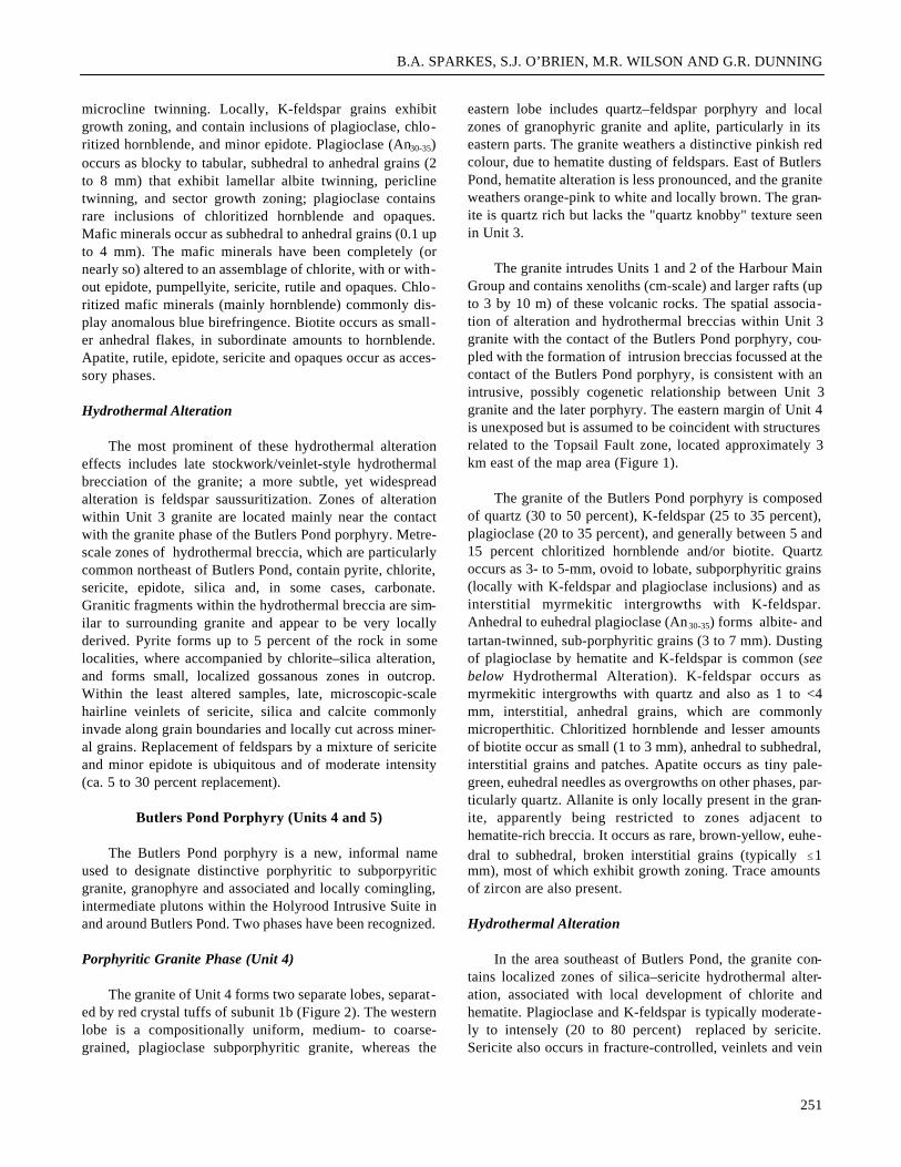
Butlers Pond Porphyry (Units 4 and 5)
The Butlers Pond porphyry is a new, informal nameused to designate distinctive porphyritic to subporpyriticgranite, granophyre and associated and locally comingling,intermediate plutons within the Holyrood Intrusive Suite inand around Butlers Pond. Two phases have been recognized.
Porphyritic Granite Phase (Unit 4)
The granite of Unit 4 forms two separate lobes, separat-ed by red crystal tuffs of subunit 1b (Figure 2). The westernlobe is a compositionally uniform, medium- to coarse-grained, plagioclase subporphyritic granite, whereas the
eastern lobe includes quartz–feldspar porphyry and localzones of granophyric granite and aplite, particularly in itseastern parts. The granite weathers a distinctive pinkish redcolour, due to hematite dusting of feldspars. East of ButlersPond, hematite alteration is less pronounced, and the graniteweathers orange-pink to white and locally brown. The gran-ite is quartz rich but lacks the "quartz knobby" texture seenin Unit 3.
The granite intrudes Units 1 and 2 of the Harbour MainGroup and contains xenoliths (cm-scale) and larger rafts (upto 3 by 10 m) of these volcanic rocks. The spatial associa-tion of alteration and hydrothermal breccias within Unit 3granite with the contact of the Butlers Pond porphyry, cou-pled with the formation of intrusion breccias focussed at thecontact of the Butlers Pond porphyry, is consistent with anintrusive, possibly cogenetic relationship between Unit 3granite and the later porphyry. The eastern margin of Unit 4is unexposed but is assumed to be coincident with structuresrelated to the Topsail Fault zone, located approximately 3km east of the map area (Figure 1).
The granite of the Butlers Pond porphyry is composedof quartz (30 to 50 percent), K-feldspar (25 to 35 percent),plagioclase (20 to 35 percent), and generally between 5 and15 percent chloritized hornblende and/or biotite. Quartzoccurs as 3- to 5-mm, ovoid to lobate, subporphyritic grains(locally with K-feldspar and plagioclase inclusions) and asinterstitial myrmekitic intergrowths with K-feldspar.Anhedral to euhedral plagioclase (An30-35) forms albite- andtartan-twinned, sub-porphyritic grains (3 to 7 mm). Dustingof plagioclase by hematite and K-feldspar is common (seebelow Hydrothermal Alteration). K-feldspar occurs asmyrmekitic intergrowths with quartz and also as 1 to <4mm, interstitial, anhedral grains, which are commonlymicroperthitic. Chloritized hornblende and lesser amountsof biotite occur as small (1 to 3 mm), anhedral to subhedral,interstitial grains and patches. Apatite occurs as tiny pale-green, euhedral needles as overgrowths on other phases, par-ticularly quartz. Allanite is only locally present in the gran-ite, apparently being restricted to zones adjacent tohematite-rich breccia. It occurs as rare, brown-yellow, euhe-dral to subhedral, broken interstitial grains (typically #1mm), most of which exhibit growth zoning. Trace amountsof zircon are also present.
Hydrothermal Alteration
In the area southeast of Butlers Pond, the granite con-tains localized zones of silica–sericite hydrothermal alter-ation, associated with local development of chlorite andhematite. Plagioclase and K-feldspar is typically moderate-ly to intensely (20 to 80 percent) replaced by sericite.Sericite also occurs in fracture-controlled, veinlets and vein
251
CURRENT RESEARCH, REPORT 02-1
bundles (locally up to 5 percent of an individual sample) thatinvade along grain boundaries and cut across grains. Horn-blende and biotite grains are altered to an assemblage ofchlorite, epidote, sericite, opaques and rutile. Hematite com-monly occurs as a dusting along feldspar grain boundaries.
The silica–sericite alteration is manifested as smallhydrothermal breccia zones (up to 3 m wide) and is locallypervasive on a submetre scale. The granite clasts commonlyrange from 1 mm to 2.5 cm and are rounded to subrounded,medium-grained and equigranular. Importantly, the graniteclasts within the silica–sericite-altered breccias are compo-sitionally similar to the auriferous, brecciated granite boul-ders found as float around the southern end of Butlers Pond.In addition, the silica–sericite alteration is of a style visual-ly similar to the first-stage alteration observed in the brec-ciated granite boulders in the southern Butlers Pond (seebelow Description of the Mineralized Rocks).
Several localized zones of stockwork-style alterationand brecciation occur close to the margins of the granite inthe area east and northeast of Butlers Pond. Chlorite is theprominant alteration phase; sericite and silica are less exten-sive, and are associated with pyrite (up to 5 percent).Hydrothermally brecciated granite was also observed imme-diately east of the hematite-rich breccias at Butlers Pond,where chlorite is again predominant. Minor silica–sericitealteration, associated with traces of pyrite, was noted ingranite exposures north of Butlers Pond. Crosscutting vein-lets of chlorite were observed in the same area.
Granodiorite–Tonalite Phase (Unit 5)
Unit 5 of the Butlers Pond porphyry is characterized bymedium- to coarse-grained rocks of granodioritic to tonaliticcomposition that display a macroscopic, subophitic texture.At the southern end of Butlers Pond, Unit 5 intrudes and isintermingled with the porphyry's granite phase; both areextensively altered, and crosscut and brecciated by ahematite-rich, hydrothermal breccia. The granodiorite–tonalite exhibits chilled margins against the granite, but bothdisplay variously inter-tonguing contacts (Plate 1), sugges-tive of a comagmatic relationship. West of Butlers Pond,Unit 5 clearly intrudes silica–sericite–pyrite-altered felsicvolcanic rocks (subunit 1b of the Harbour Main Group).North-northwest of Butlers Pond, it is intrusive into grey-green rhyodacite–dacite of subunit 1a. The northern contactof the granodiorite–tonalite in this area is unexposed, but isinferred to be intrusive into Unit 3 granite.
The granodiorite–tonalite body that hosts the hematitebreccia at Butlers Pond is compositionally and texturallysimilar to that found north of Butlers Pond (and is thus cor-
related with it), although in the latter area, silica–sericitealteration and associated pyrite mineralization is locallyextensive. The northern exposures of the granodiorite–tonalite phase tend to be coarser grained and contain segre-gations of more leucocratic and more melanocratic material.
Typically, Unit 5 is composed of quartz (20 to 40 per-cent), plagioclase (45 to 55 percent), hornblende (10 to 20percent) and K-feldspar (5 to 12 percent). Quartz occursexclusively as angular interstitial grains (# 0.5 mm) con-taining inclusions of plagioclase, K-feldspar and ferromag-nesian minerals. Plagioclase occurs as blocky to tabular,euhedral to subhedral grains (0.2 to 0.7 mm), that are affect-ed by intense sericite and lesser epidote alteration (seebelow). Anhedral K-feldspar is interstitial to plagioclase,untwinned and typically dusty-brown. Brown hornblendeoccurs as acicular, lath-like subhedral-to-anhedral grains (5to 7 mm long and 1 mm wide) exhibiting a distinctive sub-ophitic texture (intergrown with plagioclase) and are exten-sively alterated (see below). Accessory minerals includerutile, opaques, sericite, epidote, apatite, zircon and allanite.Apatite is abundant and occurs as late overgrowths, particu-larly on quartz and plagioclase grains. The apatite crystalsare mainly euhedral and acicular, measuring up to 0.5 mm inlength; they have a distinctive pale green colouration. Allan-ite occurs as euhedral grains to broken anhedra (1.2 mmlong and 0.3 mm wide) having prominent growth zoningand simple twinning. Allanite grains exhibit distinct colourzoning, including medium brown (inclusion-bearing) coresand lighter brown (inclusion-free) rims.
Hydrothermal Alteration
Several zones of extensive silica–sericite–chlorite alter-ation in Unit 5 granodiorite–tonalite are exposed in an areaof about 0.5 km2, north of Butlers Pond. Mineralization con-
252
Plate 1. Inter-tonguing of granite and granodiorite–tonalitephases of the Butlers Pond porphyry (Holyrood IntrusiveSuite) at Butlers Pond.
B.A. SPARKES, S.J. O’BRIEN, M.R. WILSON AND G.R. DUNNING
sists of up to 5 percent pyrite and forms discontinuous rustyzones of variable width and up to 10 m in length. At thesouth end of Butlers Pond, rocks of this phase are exten-sively altered and locally brecciated. Replacement offeldspars by a mixture of sericite and epidote is ubiquitous,and is generally intense (approximately 50 to 85 percentreplacement). Hornblende is altered to an assemblage ofchlorite, opaques, epidote, rutile and sericite. Allanite iscommonly rimmed by epidote and crosscut by sericite-filledfractures. Hematite-rich brecciation and alteration is appar-ently restricted to the outcrop at the south end of ButlersPond, where it has affected approximately 15 percent of theexposure. Both the feldspar–quartz-porphyritic granite andgranodiorite–tonalite phases of the Butlers Pond porphyryare affected by the hematite-rich alteration.
Age of the Butlers Pond Porphyry
A sample of porphyritic granite from the Butlers Pondporphyry was collected from the outcrop that hostshematite-rich hydrothermal breccia (Figure 2). This sampleyielded a large amount of coarse-grained euhedral prismaticzircon. Three fractions composed of 10 to 20 zircons eachwere selected for analyses. These clear and crack-free grainswere abraded prior to analysis to remove outer surfaces thatmight have undergone fluid alteration and Pb loss. Theresultant data points are all concordant within the two sigmauncertainties (0.5 to 0.7 percent discordant). As the threeanalyses have 207Pb/206Pb ages of 623 to 621 Ma, an age anduncertainty of 622 ± 2 Ma is considered the best estimate ofthe age of crystallization of this rock (Figure 3, Table 1).
253
Figure 3. Conchordia diagram for a sample from the gran-ite phase of the Butlers Pond porphyry (Holyrood IntrusiveSuite).
Tab
le 1
.U
–Pb
zirc
on d
ata
for B
utle
rs P
ond
gran
ite
Con
cent
ratio
nM
easu
red
Cor
rect
ed A
tom
ic R
atio
sA
ge (
Ma)
Tot
alW
eigh
tU
Pbco
mm
on20
6 Pb/
208 P
b/20
6 Pb/
207 P
b/20
7 Pb/
206 P
b/20
7 Pb/
207 P
b/Fr
actio
n(m
g)(p
pm)
rad
Pb (
pg)
204 P
b20
6 Pb
238 U
±23
5 U±
206 P
b±
238 U
235 U
206 P
b
Z1
10 lr
g cl
r eu
h ab
r0.
043
171
18.3
596
880.
1794
0.10
054
340.
8384
300.
0604
810
618
618
621
Z2
20 lr
g eu
h ab
r0.
047
232
25.0
2626
190.
1846
0.10
083
380.
8416
320.
0605
412
619
620
623
Z3
20 e
uh lr
g ab
r0.
024
211
22.8
213
794
0.18
490.
1008
144
0.84
1330
0.06
052
1861
962
062
2
Not
es: l
rg =
larg
e, c
lr =
cle
ar, e
uh =
euh
edra
l cry
stal
s, a
br =
abr
aded
. Unc
erta
intie
s re
port
ed a
fter
isot
opic
rat
ios
are
2 si
gma
and
refe
r to
the
fina
l dig
its
CURRENT RESEARCH, REPORT 02-1
CONCEPTION GROUP
A poorly exposed succession of siliceous siltstone andsandstone belonging to the Conception Group occupies aregion of topographically low relief in the southern part ofthe study area (Figure 2), where it is interpreted to discon-formably overlie the Butlers Pond porphyry and the HarbourMain Group. A cobble to boulder conglomerate unit, con-taining clasts of locally derived volcanic rocks andhematite-altered granite porphyry, is locally developed atthe base.
The Conception Group in this area is primarily com-posed of grey and green, buff-yellow-weathering, thin- tomedium-bedded and thinly laminated, siliceous siltstoneand fine-grained sandstone. Thin (<5 cm) cherty beds arelocally present. Granule to pebble conglomerate occurs as athin unit at the base of the siliceous siltstone–sandstonesequence. Clasts in the basal conglomerate include large (#1.5 m) boulders of vesicular basalt, clearly derived from theunderlying volcanic rocks, and felsic plagioclase porphyrypebbles and cobbles; together they constitute about 90 per-cent of the total clasts. The pebbles and cobbles are suban-gular to subrounded and average 10 cm in diameter. A num-ber of large angular float blocks (up to 3 by 2 m) of polylith-ic conglomerate are located along the projection of theunconformity along the southern shore of Butlers Pond. Theblocks contain clasts of geological units exposed nearby,including locally hematite-altered and brecciated plagio-clase porphyritic granite and quartz–feldspar porphyry ofthe Butlers Pond porphyry, as well as crystal-lithic tuff andbasalt of the Harbour Main Group. The boulders measure upto 35 cm in diameter and are set in a red, hematite-bearingsandy matrix.
Petrographic studies revealed no evidence of thermalmetamorphism in sedimentary rocks proximal to the ButlersPond porphyry.
WHALESBACK GABBRO
A small body of mafic to intermediate plutonic rocks,here included with the larger Whalesback Gabbro ofWilliams and King (1979), outcrops immediately south ofButlers Pond (Figure 2). No contacts were observed withinthe map area, but farther south, the Whalesback Gabbro isobserved to be intrusive into Conception Group sedimenta-ry rocks (Williams and King, 1979), and volcanic rocks ofthe Harbour Main Group (O' Brien et al., 1997). Exposuresin this area are mostly massive, medium- to coarse-grained,equigranular, grey-green and locally grey and white gabbroand diorite. Igneous layering, which ranges from a few cen-timetres to a few decimetres thickness, is preserved in sev-eral outcrops, and dips moderately to steeply to the west and
southwest. The glomeroporphyritic cumulate layers containintensely altered pyroxene and plagioclase grains up to 7mm in length. The gabbro is plagioclase- and pyroxene-richand commonly displays a felted, ophitic texture. Traceamounts of pyrite occur throughout.
DESCRIPTION OF THE MINERALIZED ROCKS
Hydrothermally Altered and BrecciatedGranite Boulders
Hydrothermally altered and brecciated granite bouldersthat contain copper–gold–silver mineralization are foundprimarily in the southern part of Butlers Pond; the locationof many of the larger boulders is given in Figure 2. Theboulders range in size from less than 0.5 up to 3 m, are sub-rounded to angular, and exhibit a distinctive rusty-brown-weathering surface. The sample suite examined in this studyincludes both mineralized and unmineralized, variablyaltered and brecciated granite.
The brecciated rock (Plate 2) is a medium- to coarse-grained, pink, equigranular quartz-rich granite; granite frag-ments within the breccias range from less than a millimetreto several tens of centimetres. The granite clasts containquartz (30 to 40 percent), K-feldspar (30 to 40 percent), pla-gioclase (An30-35; 15 to 25 percent), chloritized hornblende(5 to 15 percent) and trace minerals including apatite, rutile,pyrite, sericite, chlorite and carbonate. K-feldspar showsmicrocline twinning, and plagioclase shows lamellar albitetwinning, carlsbad twinning, cross-hatch twinning and com-plex sector growth zoning. Quartz and K-feldspar occur, inmany cases, as myrmekitic intergrowths. The feldspars areonly weakly saussuritized. The granite clasts are similar toequivalents of Unit 3 of the Holyrood Intrusive Suite foundnorth of Mobile Big Pond as well as brecciated and com-monly pyritic granites east of Butlers Pond (Plate 3; also seeSparkes, 2001).
The sulphides are associated with two distinct stages ofhydrothermal alteration and brecciation (Plate 2). The firststage of alteration has a characteristically light green tocream colour, and is preserved within and around brecciatedgranite clasts and is locally pervasive, replacing the originalgranite clasts. Only minor disseminated chalcopyrite is asso-ciated with this phase. Material affected by the second stageof alteration is dark greenish grey and occurs as a fracture-related, stockwork-style of brecciation that contains up to 15percent chalcopyrite (with or without pyrite) in the brecciamatrix.
The first stage of alteration consists of a very fine-grained mixture of silica and sericite, together with traceamounts of epidote and rare euhedra and subhedra of mag-
254
B.A. SPARKES, S.J. O’BRIEN, M.R. WILSON AND G.R. DUNNING
netite. The silica is very fine-grained and the sericite occursas network-like veinlets and vein-bundles. This alterationphase contains up to 3 percent total sulphides; chalcopyriteis predominant and locally associated with traces of bornite(as exsolution rims), and minor pyrite. Sulphides areanhedral and commonly isolated, whereas rare grains ofmagnetite are euhedral to subhedral.
The second (or stockwork) stage of alteration style ismanifested as a fine-grained assemblage of K-feldspar andsilica, in association with minor amounts of hydrothermalbiotite, sericite, chlorite, epidote and magnetite. Broken tofinely milled fragments of granite are incorporated into thehydrothermal matrix and partially to completely pseudo-morphed by K-feldspar. Locally, the fine-grained brecciaand associated sulphides occur along fractures in the granite
clasts. Sulphides constitute up to 15 percent of the brecciamatrix in select samples; chalcopyrite is predominant and isassociated with lesser pyrite. Chalcopyrite occurs as a sul-phide–silicate mixture as disseminations and clots reaching1 cm in diameter. It is spatially associated with (andreplaces) pyrite, in fracture-controlled veinlets that are in-turn, truncated by blebs of magnetite (Plate 4). Hydrother-mal biotite occurs as irregular patches and veinlets associat-ed with chalcopyrite in the breccia matrix (Plate 5).
Source of Mineralized Granite Boulders
No bedrock source for the mineralized boulders hasbeen identified, although a number of lines of evidencepoint to a relatively local origin. The boulders are predomi-nantly angular in nature, and appear to be clustered in asmall area. Altered and mineralized volcanic boulders foundin the same area have likely outcrop sources 500 m west of
255
Plate 2. Sample from gold-bearing chalcopyrite-rich gran-ite boulder from the shore of Butlers Pond showing first-and second-stage alteration, and illustrating nature ofgranite clasts.
Plate 3. Representative samples of Units 3 and 4 of theHolyrood Intrusive Suite at Butlers Pond and granite clastfrom the gold-bearing chalcopyrite-rich granite boulder inPlate 2.
Plate 4. Photomicrograph of chalcopyrite (cpy), pyrite (py)and magnetite (m) in gold-bearing (3.85 g/t) granite boul-der from the shore of Butlers Pond (sample BS-10).
Plate 5. Photomicrograph of biotite (bt) and chalcopyrite(cpy) in gold-bearing (3.85 g/t) granite boulder from theshore of Butlers Pond (sample BS-10).
CURRENT RESEARCH, REPORT 02-1
Butlers Pond. Glacial striae at Butlers Pond match those inthe nearby "Glazy Rocks" quartz vein outcrop, where a dis-tinctive and locally derived vein-quartz boulder trainextends less than 1 km beyond the quartz-rich outcrop. Mea-surements from both areas give similar ice-movement direc-tion (toward 090E to 105E). The orientation of these glacialfeatures agrees with the suggested ice transport of the min-eralized volcanic boulders described above and would thusimply that the brecciated granite boulders would have beentransported a similar distance.
Hematite-rich Breccia
Hematite-rich breccia is well exposed on a 16 by 7 mglacially polished outcrop in the once-flooded, southern partof Butlers Pond. This outcrop contains plagioclase por-phyritic granite and granodiorite–tonalite phases of the But-lers Pond porphyry; both are crosscut by a hematite-richhydrothermal breccia (Plate 6). The granite phase is crosscutby, and is locally inter-tongued with the granodiorite–tonalite phase prior to brecciation. Hematite-rich breccia isfound only at this exposure, where it comprises approxi-mately 10 to 15 percent of the outcrop. The area affected bybrecciation has a maximum width of 4 m and length of 12m, and a general trend of about 120 degrees. Clasts are vari-ably rounded and sized, varying from finely milled grains toclasts reaching 20 cm in diameter. The matrix of the brecciaconsists of milled fragments of granite and granodiorite–tonalite, hematite, sericite and minor chlorite (see below).
The breccia is mainly matrix-supported (up to 50 per-cent matrix) except in areas where in situ fragmentation ofgranite and granodiorite–tonalite has occurred. Both graniteand granodiorite–tonalite wall rock adjacent to the brecciazone contain hairline fractures that are filled with matrixmaterial.
The matrix of the breccia consists of red hematite,sericite, chlorite, epidote, biotite, specular hematite, andtrace amounts of chalcopyrite, together with quartz andmilled fragments of both granite and granodiorite–tonalitephases of the Butlers Pond porphyry. The assemblage ofminerals can be separated into two classes, viz. , those incor-porated during brecciation of the wall rocks and those ofhydrothermal (fluid-derived) origin.
Biotite, specular hematite and quartz are locally derivedfrom the adjacent wall rocks (i.e., primary), and in some sec-tions, both primary biotite and specular hematite were foundto be partially brecciated, incorporated into, and stable with-in the hydrothermal matrix material. Hydrothermal alter-ation mineralogy in the hematite-rich breccia is dominatedby hematite and sericite, the latter occurring as hairline vein-lets and veinlet bundles within the breccia matrix, and found
where in situ brecciation of wall rock has occurred. Minoramounts of very fine-grained chlorite and trace amounts ofvery fine-grained, anhedral chalcopyrite grains have alsobeen observed. The sericite–hematite veinlets appear topreferentially rim larger granite clasts in areas of mainly insitu brecciation.
OTHER MINERALIZED ROCKS
West of Butlers Pond, hydrothermal alteration and asso-ciated pyrite mineralization occur in internally brecciatedsubvolcanic felsic porphyry dykes within mafic volcanicrocks. The dykes are extensively silicified and sericitizedand may contain up to 5 percent pyrite cubes (# 4 mm). Thefelsic fragments are pink where unaltered but are grey-brown where silicified. The breccia contains anomalousmetal values, viz. , 65 ppb Au, 667 ppm Cu, 427 ppm Pb, 672ppm Zn and 62 ppm Mo; comparable values from similarrocks in the same area were reported by Pickett, (1995,1996). In thin section, pyrite occurs as mainly euhedral andbroken cubes, up to 4 mm across, with trace chalcopyriteoccurring along pyrite grain boundaries and as intergrowthswith the pyrite. The pyrite and chalcopyrite are intergrownand associated with fine-grained, anhedral and interlocking,intense mosaic-textured, stockwork silicification. The silica-flooded rock is cut by minor, coarser grained quartz veinlets.Trace amounts of epidote and sericite accompany the earlysilica–pyrite stockwork-flooding.
Pickett (1996) noted zones of epidote, with or withoutsilica, carbonate alteration and quartz–carbonate veining inbasalt in drill core west of Butlers Pond (Avalon Mines drill-holes BP-95-A1 and BP-95-A2), locally associated withstringer-type sulphide mineralization. Assay data include up
256
Plate 6. Hematite-rich breccia from the main breccia out-crop at the south end of Butlers Pond showing both phasesof Butlers Pond porphyry and in situ brecciation.
B.A. SPARKES, S.J. O’BRIEN, M.R. WILSON AND G.R. DUNNING
to 1820 ppm Cu, 5100 ppm Zn, and 1975 ppm Pb for thesesections of sulphide stringers in the two drill cores (Pickett,1996). Crocker and Dalton (1994) noted that chalcopyriteand possibly chalcocite stringers cut the basalt about 500 mwest of Butlers Pond. Assay values from grab samples fromthis area returned results up to1% Cu and 7.8 g/t Au.
GEOCHEMISTRY OF THEINTRUSIVE ROCKS
Geochemical data from intrusive rocks of the HolyroodIntrusive Suite in the Butlers Pond area are presented inTables 2, 3 and 4, and include ICP-ES3 data from the geo-chemical laboratory of the Newfoundland and LabradorGeological Survey and INAA4 data from Activation Labora-tories Limited (including REE's and Au). Tables outliningdetection limits of both major- and trace-element analysis,along with preparation and determination procedures for theICP-ES technique are given in Finch (1998); procedures anddetection limits for the INAA technique are outlined in Dav-enport (1988). These major-element, trace-element and rare-earth-element data are treated in detail in Sparkes (2001)and only a brief summary of some pertinent aspects is givenbelow.
MAJOR AND TRACE ELEMENTS
The major- and trace-element data help identify first-order geochemical characteristics of the intrusive phases asidentified by field mapping and petrography, which aid indetermining the geological setting and mineral-deposit styleof the rocks at Butlers Pond. These data are consistent withpetrographic data, which together confirm that the felsicplutonic units at Butlers Pond are hornblende–biotite-bear-ing, I-type granites of calc-alkaline affinity (Sparkes, 2001;Figure 4). These rocks also fall in the field of volcanic-arcgranites (cf. Pearce et al., 1984). Mineralization withingranite boulders is enriched in Cu, low in Mo and locallyAu-rich (up to 3.85 g/t Au in this study and up to 12.8 g/t inprevious work). The chemistry of the granites, including thatof the mineralized boulders, is consistent with that of rocksknown to be associated with gold-rich porphyry deposits(e.g., Sillitoe, 1993). The outcrop exposure of hematite-richbreccia did not return anomalous values for Cu, Au, Ag, Moor U (Tables 3 and 4), elements commonly enriched in Fe-oxide copper–gold style mineralized systems (cf. Reeve etal., 1990).
Incompatible trace elements are those that favour themelt phase over the solid during melting or crystallization,
whereas compatible elements favour the solid phase overthe melt/magma (Jenner, 1996). On incompatible versusincompatible trace-element plots, rocks related to one anoth-er by simple fractionation generally show trends starting ator near the origin with a positive slope to the right withincreasing differentiation (e.g., Y vs. Zr, Figure 5). Compat-ible versus compatible element plots (e.g., TiO2 vs. V) gen-erally show fractionation trends from the upper right towardthe origin, with increasing differentiation. Compatible ver-sus incompatible element plots (e.g., TiO2 vs. Zr) generallyshow fractionation trends from the upper left toward thelower right with increasing fractionation. The Y vs. Zr andDy vs. Y plots indicate a fractionation trend may existbetween granites from Unit 3 and Unit 4, with Unit 4 gran-ite being more fractionated. If Unit 5 granodiorite–tonalitewas related by simple fractionaltion to either of the granites,then the mafic rocks would be expected to have lower abun-dances of Y, Zr and REEs (e.g., Dy) than either of the gran-ites. This is not the case (Figure 5). Whereas the granodior-ite–tonalite has higher abundances of compatible elements(e.g., Ti, Sc and V) compared to the granite (features con-sistent with their mafic composition) the enrichments ofincompatible elements (Y, Zr and REEs) in these maficrocks appear to preclude them being related by simple frac-tionation to the granite suites.
PRIMITIVE-MANTLE-NORMALIZED ELEMENT PLOTS
Plots of primitive-mantle-normalized elements are con-sistent with major- and trace-element data in suggesting apossible genetic link between the granites of Units 3 and 4.The primitive-mantle-normalized trace-element plot (Figure6) was constructed from ICP-ES data and normalized to val-ues obtained from Sun and McDonough (1989). Granitesfrom Units 3 and 4 both have similar, negatively slopingtrends between LaN and DyN (Unit 4 has slope ~13; Unit 3has slope ~15), in contrast to the shallower slope (~ 6.7) ofthe granodiorite–tonalite. The steep slope between LaN andDyN indicates an overall calc-alkaline trend for the granites.Both granite fields have low LiN values (~0.7 to 4), elevatedBaN and K2ON values (~100 to 180), slightly negative NbN,P2O5N and TiO2N anomalies, and negatively sloping trendstoward the lower right of the diagram, suggesting a geneticlink. The granodiorite–tonalite has a lower slope from LaN
and DyN, higher LiN values than the granite, and lacks thelatter's prominent P2O5N anomaly, suggesting that the inter-mediate rocks are not related to the granite through frac-tionation, and have a unique source.
The normalized REE plot of INAA data for Units 3, 4and 5 of the Holyrood Intrusive Suite (Figure 7) was con-structed using primitive-mantle values obtained from Sunand McDonough (1989). All three units are enriched inLREE (LaN, CeN, NdN and SmN); they have similar, steep,negatively sloping trends (Unit 4 ~ 11.5, Unit 5 ~ 6.7 andUnit 3 ~ 10) from LaN to SmN and, relatively flat trends fromEuN to LuN. The trends and negative slopes in both INAAand ICP-AES data are similar, both suggesting calc-alkalineaffinities and possible genetic links between the two granitephases. The pronounced difference in slope between Units 4and 5 again argues against a genetic link through fractiona-tion. The data are relatively well clustered, with the excep-tion of EuN values; the spread in these data likely representsmodal abundances of plagioclase.
SUMMARY AND CONCLUSIONS
1. The late Proterozoic geological record as preservedin rocks at Butlers Pond is one of mainly subaerial, pyro-clastic and locally subaqueous volcanism of felsic through
intermediate to mafic composition, followed by theemplacement at high crustal levels of a composite, metallo-genically important plutonic suite, between 625 and 620Ma. Tilting, exhumation, erosion and submergence of thevolcano-plutonic rocks occurred prior to emplacement of alater spatially restricted suite of mafic intrusive rocks of pre-sumed late Proterozoic age.
2. The data support a co-magmatic relationship betweengranite typical of the main, areally extensive, hornblende–biotite granite phase of the Holyrood Intrusive Suite, datedelsewhere at 620 ± 2 Ma and 623 ± 3 Ma, and the newlydated 622 ± 2 Ma Butlers Pond porphyry.
3. Integration of these new data with that from regionalmapping and geochronological studies elsewhere in the cen-tral Avalon Peninsula, allows for the correlation of subaeri-al explosive volcanism recorded in the Butlers Pond areawith volcanism dated between 630 to 620 Ma in nearbyparts of the Holyrood Horst (e.g., southern parts of theHawke Hills tuff, Figure 1). Plutonism and volcanism are
258
Table 2. Major-element analyses of representative plutonic rocks form the Butlers Pond area
B.A. SPARKES, S.J. O’BRIEN, M.R. WILSON AND G.R. DUNNING
259
Tab
le 3
.Tab
le o
f tr
ace
elem
ents
for
rep
rese
ntat
ive
sam
ples
of
plut
onic
roc
ks f
rom
the
But
lers
Pon
d ar
ea
Sam
ple
Map
Cr
ZnPb
Co
Ni
FeC
dTi
VB
eN
bC
uD
ySc
YZ
rM
nSr
La
Ce
Ba
LiA
sN
umbe
rU
nit
ppm
ppm
ppm
ppm
ppm
%pp
mpp
mpp
mpp
mpp
mpp
mpp
mpp
mpp
mpp
mpp
mpp
mpp
mpp
mpp
mpp
mpp
m
OB
-00-
094
32
6013
32
1.08
0.5
1328
131
841
15
1277
677
168
2129
1043
34
OB
-00-
095
31
313
22
1.05
0.5
1261
91
71
24
1712
141
812
527
3710
024
2O
B-0
0-12
33
132
82
21.
020.
510
736
27
12
313
9155
118
522
3083
37
4O
B-0
0-12
43
127
51
10.
680.
584
72
210
11
310
7446
010
620
3010
483
3O
B-0
0-12
53
137
12
21.
190.
512
378
28
12
418
106
564
151
2637
923
55
OB
-00-
127
31
432
32
1.35
0.5
1427
102
91
24
1710
469
221
728
3810
475
1O
B-0
0-25
73
144
43
21.
500.
515
1213
210
12
414
120
717
195
3143
1056
65
OB
-00-
258
31
4214
32
1.35
0.5
1353
122
82
24
1613
067
120
228
4110
918
2O
B-0
0-26
13
127
141
10.
650.
583
34
110
11
311
9435
310
922
3395
45
4O
B-0
0-26
23
125
121
10.
540.
560
71
19
11
210
6444
410
019
3198
03
1O
B-0
0-26
63
143
174
21.
370.
514
5518
29
22
516
9371
719
525
3579
64
1
OB
-00-
103
41
355
33
1.20
0.5
1300
111
84
24
1413
952
712
123
3691
74
3O
B-0
0-10
34
135
152
21.
030.
512
0811
16
32
413
138
483
115
2232
944
33
OB
-00-
108
41
791
54
2.55
0.5
2465
182
1014
36
19n.
d.97
423
714
2987
87
4O
B-0
0-11
54
132
13
21.
320.
514
299
210
24
526
170
507
100
3751
1049
44
OB
-00-
115
41
325
22
1.09
0.5
1301
82
104
34
1915
945
693
2650
985
32
OB
-00-
159
41
381
32
1.68
0.5
1777
172
916
35
1922
548
921
437
5696
05
4O
B-0
0-15
94
129
83
21.
270.
514
1713
18
163
420
172
381
162
3145
1164
44
OB
-00-
304
41
422
32
1.37
0.5
1612
102
122
25
1917
460
313
820
3593
93
3O
B-0
0-30
54
164
384
12
1.26
0.1
1572
121
119
15
8n.
d.24
799
913
946
129
BS-
25
183
88
43.
520.
536
1642
28
273
1121
153
979
204
2943
904
123
OB
-00-
160
51
931
84
3.85
0.5
4014
492
83
413
2317
811
5716
328
4610
9715
6O
B-0
0-16
25
197
18
44.
050.
540
7957
28
23
1422
139
1260
191
2543
907
175
OB
-00-
300
51
120
47
43.
980.
537
7451
29
53
1226
n.d.
1885
280
3148
600
134
BS-
9CG
Mbo
ulde
r1
265
22
0.92
0.5
1095
31
627
001
311
131
367
678
1393
93
4B
S-9G
RC
boul
der
129
62
20.
950.
512
733
17
3504
13
1514
640
074
812
1068
34
OB
-00-
161
4 H
em-b
x10
5013
233
1.32
0.5
1298
91
713
24
17n.
d.36
512
727
4310
253
6O
B-0
0-16
51b
Bx
567
242
710
93.
698.
311
1818
13
667
14
7n.
d.65
2716
2551
01
3
n.d.
- no
t det
erm
ined
CURRENT RESEARCH, REPORT 02-1
260
Tab
le 4
.Tab
le o
f tr
ace
and
rare
-ear
th-e
lem
ents
det
erm
ined
by
INA
A f
or r
epre
sent
ativ
e pl
uton
ic r
ocks
fro
m th
e B
utle
rs P
ond
area
Sam
ple
Map
Au
Ag
As
Ba
Br
Co
Cr
Cs
Hf
Mo
Na
Rb
SbSc
TaTh
UZn
La
Ce
Nd
SmEu
Tb
Yb
Lu
Num
ber
Uni
tpp
bpp
mpp
mpp
mpp
mpp
mpp
mpp
mpp
mpp
m%
ppm
ppm
ppm
ppm
ppm
ppm
ppm
ppm
ppm
ppm
ppm
ppm
ppm
ppm
ppm
OB
-00-
094
32
b.d.
172
0b.
d.2
b.d.
b.d.
2b.
d.2.
6578
0.2
3.9
b.d.
6.5
1.8
6320
2910
1.9
0.5
0.7
1.4
b.d.
OB
-00-
095
34
b.d.
1.5
750
b.d.
2b.
d.1
3b.
d.2.
5179
0.3
3.4
b.d.
81.
4b.
d.22
3215
2.7
0.6
b.d.
2b.
d.O
B-0
0-12
33
1b.
d.1
660
b.d.
2b.
d.
13
22.
7796
0.2
2.8
b.d.
7.9
1.3
b.d.
2028
152
0.6
b.d.
1.5
b.d.
OB
-00-
124
3b.
d.b.
d.b.
d.87
0b.
d.1
b.d.
b.d.
3b.
d.2.
9593
b.d.
3.1
1.3
111.
6b.
d.23
3314
2b.
d.b.
d.1.
7b.
d.O
B-0
0-12
53
b.d.
b.d.
1.8
720
b.d.
1b.
d.b.
d.3
b.d.
3.07
90b.
d.3.
21.
29.
11.
7b.
d.24
3416
2.5
0.6
b.d.
1.9
b.d.
OB
-00-
127
34
b.d.
1.2
750
b.d.
2b.
d.2
32
2.83
74b.
d.3.
3b.
d.7.
51.
6b.
d.24
3314
2.2
0.7
b.d.
1.8
b.d.
OB
-00-
103
4b.
d.b.
d.1.
677
0b.
d.2
b.d.
14
b.d.
2.72
140
b.d.
3.7
0.8
113.
190
2638
192.
80.
50.
52.
3b.
d.O
B-0
0-15
94
b.d.
b.d.
1.8
780
b.d.
2b.
d.1
5b.
d.3.
3570
b.d.
4.5
b.d.
8.1
1.3
b.d.
3250
233.
61.
1b.
d.2.
1b.
d.
OB
-00-
160
53
b.d.
1.7
820
b.d.
7b.
d.2
42
2.40
170
0.2
11b.
d.5.
51.
781
2640
234
1.3
b.d.
2.6
b.d.
OB
-00-
162
53
b.d.
1.5
760
b.d.
6b.
d.3
4b.
d.2.
7812
00.
112
b.d.
5.9
1.4
6924
3718
3.8
1.1
0.6
2.8
b.d.
BS-
9CG
Mbo
ulde
rb.
d.b.
d.b.
d.96
00.
82
b.d.
b.d.
4b.
d.2.
9071
0.3
3.1
1.1
7.6
2.3
b.d.
8.2
16b.
d.1.
2b.
d.b.
d.2
b.d.
BS-
9GR
Cbo
ulde
rb.
d.b.
d.2.
210
00b.
d.2
b.d.
14
b.d.
2.98
670.
23.
30.
89.
51.
9b.
d.7.
518
b.d.
1.3
b.d.
0.7
2.7
b.d.
BS-
5bo
ulde
rb.
d.b.
d.1.
895
00.
82
b.d.
26
133.
0513
00.
66.
40.
912
1.9
b.d.
1425
92.
20.
5b.
d.2
b.d.
BS-
6bo
ulde
rb.
d.b.
d.1.
950
0b.
d.3
82
529
1.65
160
0.4
110.
711
2b.
d.17
3310
2.7
0.7
0.7
5.5
0.82
BS-
7bo
ulde
r30
b.d.
4.8
2400
b.d.
1525
22
433.
3777
0.1
15b.
d.1.
2b.
d.b.
d.2.
28
b.d.
1b.
d.b.
d.1.
1b.
d.B
S-8
boul
der
52b.
d.1.
689
0b.
d.3
b.d.
b.d.
4b.
d.2.
6011
00.
24
b.d.
111.
3b.
d.15
279
1.6
b.d.
0.7
2.4
b.d.
BS-
10bo
ulde
r38
5043
2.1
850
b.d.
2b.
d.b.
d.3
b.d.
2.39
860.
43.
2b.
d.9.
11.
8b.
d.24
419
2.1
0.6
b.d.
2.1
b.d.
OB
-00-
161
4 he
m B
x2
b.d.
1.3
830
b.d.
3b.
d.1
44
3.54
380.
23.
60.
88.
31.
1b.
d.27
4619
3.3
0.8
b.d.
2.3
b.d.
OB
-00-
165
1b h
-bx
65b.
d.1.
752
0b.
d.7
b.d.
b.d.
262
0.96
30b.
d.3.
50.
22.
40.
767
315
298
1.5
b.d.
b.d.
1.1
b.d.
b.d.
= b
elow
det
ectio
n lim
it
B.A. SPARKES, S.J. O’BRIEN, M.R. WILSON AND G.R. DUNNING
thus considered coeval. Furthermore, observed contact rela-tionships consistently indicate that all volcanic sequences inthe study area (including mineralized units) are older than620 Ma, and thus unrelated to 580 Ma and younger Protero-zoic volcanism elsewhere in the Avalon Zone.
4. Following the emplacement of the Holyrood IntrusiveSuite between 625 and 620 Ma, a period of uplift and ero-sion resulted in the unroofing of the plutons and the intrud-ed volcanic pile. Marine sedimentary rocks record a sub-mergence of the volcano-plutonic complex, which has alsobeen documented in other areas, both within and adjacent tothe Holyrood Horst (O'Brien et al., 2001a). Existing data donot preclude correlation with 621 +5/-4 Ma marine sedi-mentary rocks in the northern Holyrood Horst (Israel, 1998;O'Brien et al., 2001a), although such a correlation requiresessential contemporaneity of volcanism, plutonism, uplifterosion and submergence. An alternate correlation is withthe post-580 and pre-565 Ma, marine, siliciclastic sedimen-tary rocks of the Conception Group east of the Topsail Fault(King, 1988; O'Brien et al., 2001a).
5. Whole-rock geochemistry indicates a possible geneticrelationship, through fractionation, between the main horn-blende–biotite granite phase (Unit 3) of the Holyrood Intru-sive Suite and the granite phase (Unit 4) of the Butlers Pondporphyry. The similar chemical affinities of Units 3 and 4are consistent with a contemporaneity that is independentlydemonstrated by the geochronological data. Both phases areLREE-enriched, calc-alkaline magmas likely related to asubduction-related, volcanic arc. Available data, however,argue against a simple fractionation relationship between thecoeval and comingling granodiorite–tonalite and granitephases of the Butlers Pond porphyry.
6. Documented mineralization in the Butlers Pond areashares several characteristics with that found in porphyrycopper–gold deposits. The alteration assemblages associatedwith copper–gold mineralization in locally derived bouldersinclude K-feldspar–biotite–magnetite–silica (potassic) inthe second-stage (stockwork) alteration as well as an earlierstyle of silica–sericite-dominated alteration. Both assem-blages are consistent with porphyry-style copper–golddeposits, such as those described by Sillitoe (1979, 1991,1993), Corbett and Leach (1998) and Titley (1994). Otherobservations consistent with such a model include theoccurrence of silica–sericite alteration zones with associatedpyrite mineralization found southeast, west and north ofButlers Pond, and also the calc-alkaline composition, I-typeaffinity and volcanic-arc-like signature of granite hostrocks.
7. The protolith of the copper–gold mineralized brecciais indistinguishable from equigranular phases of the Holy-rood Intrusive Suite that are widely developed north of theButlers Pond region. Similar granite, with comparable sili-ca–sericite–pyrite alteration, also occurs in the area south-east of Butlers Pond. This indicates a potential for such astyle of mineralization elsewhere in this region, particular-ly in areas where phases similar to the Butlers Pond por-phyry are present. The 622 ± 2 Ma age of the Butlers Pondporphyry demonstrates that intrusive rocks associated withhydrothermal alteration, brecciation and mineralization atButlers Pond are not anomalous, vis-a-vis age, relative tomost of the Holyrood Intrusive Suite. This further demon-strates that the suite has potential to host to porphyry-styleCu–Au deposits at Butlers Pond and possibly elsewhere inthe region. These new data, however, confirm that this plu-tonism cannot be directly related to formation of the 580 to570 Ma magmatic arcs hosting the extensive late Protero-zoic high- and low-sulphidation Avalonian epithermal sys-tems in the Hickey’s Pond, Hope Brook and Manuels areasof southern and eastern Newfoundland (e.g., O’Brien et al.,2001a,b). The magmatism recorded at Butlers Pond, howev-er, is approximately coeval with plutonism related to small,intrusion-related copper–gold–molybdenum systems inAvalonian rocks in Cape Breton (e.g., Lynch and Ortega,1997).
8. Available field, petrographic and geochemical datasuggest that the hematite-rich brecciation associated withsome areas of the Butlers Pond porphyry pluton is not of thetype related to many iron-oxide–copper–gold systems. Therestricted extent, negative geochemical signatures of thehematite-rich breccia (i.e., low U, Cu, Au, Ag and REE's)and the I-type affinity and mineralogy (e.g., no fluorine-bearing phases) of the host granite are not consistent withthis deposit model. The brecciation is largely in situ and maybe related to local mechanical brecciation during release ofvolatile-rich fluids near the interface with country rocks or a
261
Figure 4. Rb vs Nb+Y trace-element diagram showing com-positions of Units 3 and 4 relative to fields for I-, S-, A- andOR-type granites (modified from Pearce et al., 1984, Ray etal., 1995 and Christiansen and Keith, 1996).
CURRENT RESEARCH, REPORT 02-1
262
Figure 5. Bivariate trace-element geochemical plots for Units 3, 4 and 5 of the Holyrood Intrusive Suite in the Butlers Pondarea.
Figure 6. Normalized multi-element geochemical plots forUnits 3, 4 and 5 of the Holyrood Intrusive Suite in the But-lers Pond area.
Figure 7. Normalized rare-earth-element geochemical plotsfor Units 3, 4 and 5 of the Holyrood Intrusive Suite in theButlers Pond area.
B.A. SPARKES, S.J. O’BRIEN, M.R. WILSON AND G.R. DUNNING
chilled magma carapace. The thick pile of oxidized maficand felsic volcanic rocks adjacent to the west margin of por-phyry may be the source of hematite in these breccias.
ACKNOWLEDGMENTS
The authors thank Chris Finch for providing ICP data,Tony Paltanavage for help with final figure preparation, andthe staff of Altius Minerals Corporation for access to mate-rials from the Butlers Pond area and for their supportthroughout this project. Paul Crocker is thanked for accom-panying the authors on a field trip to the area. The manu-script was reviewed by Lawson Dickson.
REFERENCES
Corbett, G.J. and Leach, T.M.1998: Southwest Pacific Rim gold–copper systems:structure, alteration, and mineralization. Society ofEconomic Geologists, Special Publication Number 6,237 pages.
Christiansen and Keith1996: Trace element systematics in silicic magmas: ametallogenic perspective, In Trace Element Geochem-istry of Volcanic Rocks: Applications for Massive Sul-phide Exploration; Edited by D.A.Wyman. GeologicalAssociation of Canada, Short Course Notes, volume 12, pages 115-151.
Crocker, P. and Dalton, B.1994: The second year assessment report on groundstaked licence 4197, claim block 7693, Butler's Pondproperty. Unpublished report, Cape Broyle ExplorationLimited.
Davenport, P.H.1988: The use of multi-element neutron activationanalysis of organic lake sediment in geochemical explo-ration for gold. In Current Research. NewfoundlandDepartment of Mines, Mineral Development Division,Report 88-1, pages 403-414.
Finch, C.J.1998: Inductively coupled plasma-emission spectrome-try (ICP-ES) at the geochemical laboratory. In CurrentResearch. Newfoundland Department of Mines andEnergy, Geological Survey, Report 98-1, pages 179-194.
Israel, S.1998: Geochronological, structural and stratigraphicinvestigation of a Precambrian unconformity betweenthe Harbour Main Group and Conception Group, eastcoast Holyrood Bay, Avalon Peninsula, Newfoundland.
Unpublished B.Sc. (Honours) thesis, Memorial Univer-sity of Newfoundland, St. John's, Newfoundland, 78pages.
Jenner, G.A.1996: Trace element geochemistry of igneous rocks:geochemical nomenclature and analytical geochem-istry. In Trace Element Geochemistry of VolcanicRocks: Applications For Massive Sulphide Exploration.Edited by D.A. Wyman. Geological Association ofCanada, Short Course Notes, Volume 12, pages 51-77.
King, A.F.1988: Geology of the Avalon Peninsula, Newfoundland(parts of 1K, 1L, 1M, 1N and 2C). NewfoundlandDepartment of Mines, Mineral Development Division,Map 88-01.
Krogh, T.E., Strong, D.F., O'Brien, S.J. and Papezik, V.S.1988: Precise U-Pb zircon dates from the Avalon Ter-rane in Newfoundland. Canadian Journal of Earth Sci-ences, Volume 25, pages 442-453.
Lynch, G. and Ortega, J.1997: Hydrothermal alteration and tourmaline–albiteequilibria at the Coxheath Cu–Mo–Au deposit, NovaScotia. The Canadian Mineralogist, Volume 35, pages79-94.
1969: Geology of the Avalon Peninsula, southeast New-foundland. In North Atlantic - Geology and ContinentalDrift. Edited by M. Kay. American Association ofPetroleum Geologists, Memoir 12, pages 115-129.
Mullins, J.1970: Geology of the St. Catherine's (east half) maparea (1N/3, E½). Newfoundland Department of Mines,Agriculture and Resources, Mineral Resources Divi-sion, Geological Report No. 15, 13 pages.
O'Brien, S.J., Dubé, B. and O' Driscoll, C.F.2001b: Epithermal-style Hydrothermal Systems in LateNeoproterozoic Avalonian Rocks on the Avalon Penin-sula, Newfoundland: Implications for Gold Explo-ration. Field Trip A-6 Guidebook. St. John's 2001 Geo-logical Association of Canada - Mineralogical Associa-tion of Canada Annual Meeting, 29 pages.
O'Brien, S.J., Dunning, G.R., Dubé, B., O' Driscoll, C.F.,Sparkes, B., Israel, S. and Ketchum, K.
2001a: New insights into the Neoproterozoic geology
263
CURRENT RESEARCH, REPORT 02-1
of the central Avalon Peninsula (parts of NTS map areas1N/6, 1N/7 and 1N/3), eastern Newfoundland. In Cur-rent Research. Newfoundland Department of Mines andEnergy, Geological Survey, Report 01-1, pages 169-189.
O'Brien, S.J., King, A.F. and O' Driscoll, C.F.1997: Late Neoproterozoic geology of the central Aval-on Peninsula, Newfoundland, with an overview of min-eralization and hydrothermal alteration. In CurrentResearch. Newfoundland Department of Mines andEnergy, Geological Survey, Report 97-1, pages 257-282.
Pearce, J.A., Harris, N.B. and Tindle, A.G.1984: Trace element discrimination diagrams for thetectonic interpretation of granitic rocks. Journal ofPetrology, Volume 25, pages 956-983.
1996: Assessment report: Geological mapping, inducedpolarization surveying and diamond drilling, Butler'sPond property. Licences 4197 and 4468, southeasternNewfoundland, NTS 1N/2 and 1N/3. 12 pages plusappendices.
Ray, G.E., Webster, I.C.L. and Ettlinger, A.D.1995: The distribution of skarns in British Colombiaand the chemistry and ages of their related plutonicrocks: Economic Geology, volume 90, pages 920-937.
Reeve, J.S., Cross, K.C., Smith, R.N. and Oreskes, N.1990: Olympic Dam copper–uranium–gold–silverdeposit. In Geology of the Mineral Deposits of Aus-tralia and Paupa New Guinea. Edited by F.E. Hughes.The Australasian Institute of Mining and Metallurgy,Melbourne, pages 1009-1035.
Sun, S.S. and McDonough, W.F. 1989: Chemical and isotopic systematics of oceanicbasalts: Implications for mantle composition andprocess. In Magmatism in the Ocean Basins. Geologi-cal Society, Special Publication 42, pages 313-345.
Sillitoe, R.H.1979: Some thoughts on gold-rich porphyry copperdeposits. Mineralium Deposita, Volume 14, pages 161-174.
1991: Intrusion related gold deposits. In Gold Metal-logeny and Exploration. Edited by R.P. Foster. London,Blackies, pages 165-209.
1993: Gold-rich porphyry deposits: geological modeland exploration implications. In Mineral Deposit Mod-elling. Edited by R.V. Kirkham, W.D. Sinclair, R.I.Thorpe and J.M. Duke. Geological Association ofCanada, Special Paper 40, pages 465-478.
Sparkes, B.A.2001: The geologic setting, petrography and geochem-istry of plutonic rocks and associated mineralizationand alteration in Neoproterozoic rocks of the ButlersPond area, eastern Avalon Zone, Newfoundland.Unpublished B.Sc. (Honours) thesis, Memorial Univer-sity of Newfoundland, St. John's, Newfoundland, 151pages.
Titley, S.R.1994: Evolutionary habits of hydrothermal and super-gene alteration in intrusion centred ore systems, south-western North America. In Alteration and AlterationProcesses Associated with Ore Forming Systems. Edit-ed by E.R. Lentz. Geological Association of Canada,Short Course notes, Volume 11, page 237-260.
Williams, H. and King, A. F.1979: Trepassey map area, Newfoundland. GeologicalSurvey of Canada, Memoir 389, 24 pages.