Please do not destroy or throw away this publication. If you have no further use for it write to the Geological Survey at Washington and ask for a frank to return it DEPARTMENT OF THE INTERIOR Hubert Work, Secretary U. S. GEOLOGICAL SURVEY George Otis Smith, Director Bulletin 795 F THE GILBERT DISTRICT, NEVADA BY HENRY G. FERGUSON Contributions to economic geology, 1927, Part I (Pages 125-145) Published November 4,1927 UNITED STATES GOVERNMENT PRINTING OFFICE WASHINGTON 1927
Transcript
Please do not destroy or throw away this publication. If you have no further use for it write to the Geological Survey at Washington and ask for a frank to return it
DEPARTMENT OF THE INTERIORHubert Work, Secretary
U. S. GEOLOGICAL SURVEY George Otis Smith, Director
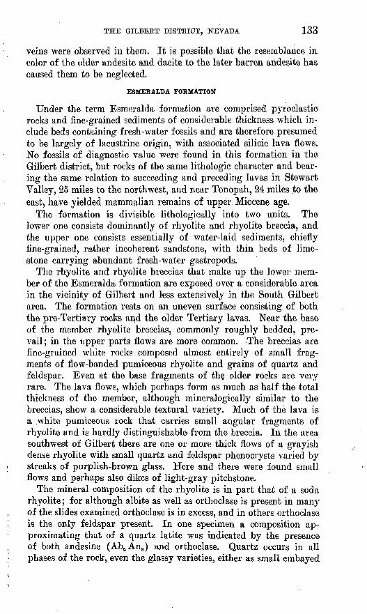
PageFiGUKE9. Map showing location of the Gilbert district, Nev____ _ 126
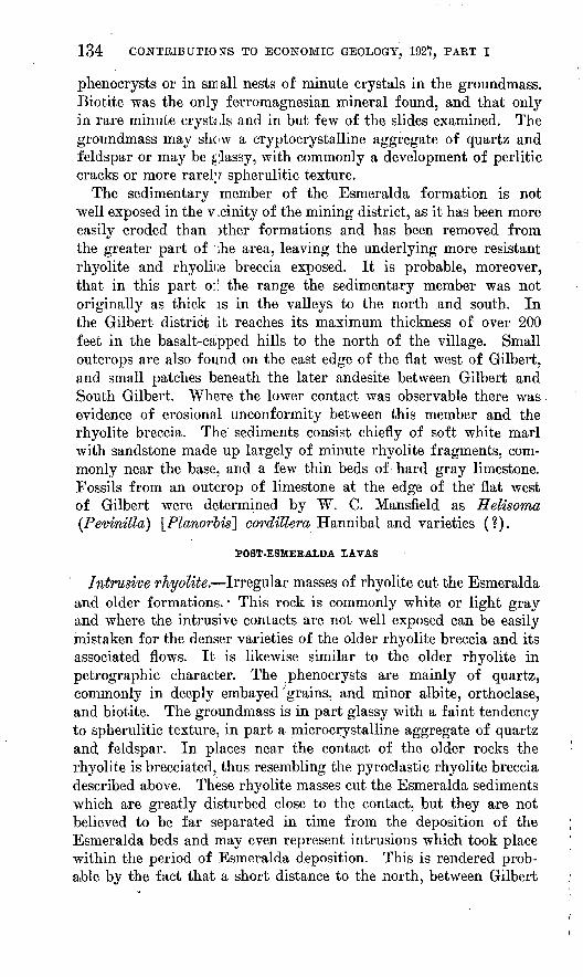
10. Geologic map and section of the Gilbert district, Nev 127
ii
THE GILBERT DISTRICT, NEVADA
By HENRY G. FERGTJSON
INTRODUCTION
The eastern part of the Monte Cristo Range, in Esmeralda County, Nev., has been prospected for many years, and one mine, the Carrie, was developed as early as 1890. The discovery of high-grade ore by the Gilbert brothers on the Last Hope claim in 1924 led to a boom during which the region was extensively prospected and claims were staked out covering not only the Gilbert district but another area from which the barren later andesite has been eroded, known as South Gilbert. The total production for the years 1917-1925, accord ing to data furnished by Mr. V. C. Heikes, U. S. Bureau of Mines, amounted to $24,807, about two-thirds of which was from gold.
The Gilbert camp, in the northern part of Esmeralda County, is about 25 miles west of Tonopah. (See fig. 9.) Fair desert roads con nect the district with Tonopah and Mina. The nearest railroad point is Gilbert Junction (formerly known as McLeans siding), on the Tonopah & Goldfield Railroad, about 10 miles by road from Gilbert and 5 miles from South Gilbert.
The site of the district had been visited by the writer and S. H. Cathcart in the summer of 1922 in the course of a rapid reconnaissance of the areal geology of the Tonopah quadrangle. At that time Mr. Cathcart visited the Carrie mine, now idle, and his notes have been incorporated in the present report. The wide advertising which the district received during the spring of 1925 made further study de sirable, and accordingly the writer and Mr. G. H. White spent about 10 days in the vicinity of Gilbert in October, 1925. At this time the geology was mapped in some detail and visits were paid to nearly all the prospects in the immediate vicinity of Gilbert and South Gilbert. The writer desires to acknowledge the assistance rendered by Mr. L. B. Spencer, a mining engineer whose thorough acquaint ance with the district greatly facilitated the work. The accompany ing geologic map (fig. 10) is based on the accurate claim map of
125
126 CONTRIBUTIONS TO ECONOMIC GEOLOGY, 1927, PART I
the district made by Messrs. Liddell and Spencer. Had this not been available it would not have been possible to map the areal geology in the short time available.
From the amount of publicity which the district received during the boom, it had been expected that during the year which had elapsed since the discovery development work would be well ad vanced. In this, however, the writer was disappointed. It was
,v \ a&x .x r**rtf ?,%&»\ ti V N />/
M F ^^i^W fi1" A Jii -3^^ M- J-* tt ->^ypt. J-' A
FIGDRB 9. Map of a portion of western Nevada showing location of the Gilbert district
found that only a very small amount of work had been done and that much of that was ill advised. Consequently it has not been found possible to draw any very definite conclusions as to the future possibilities of the district. The showings found, however, are cer tainly such as to justify further work. It is hoped, therefore, that the brief summary of the geology contained in the following pages
Slate, chert.and quarlzite with some thin beds of crystalline limestone
ORDOVICIAN(?)JURASSIC TERTIARY QUATERN/
CRETACEOUS
Contour interval 100 feet JJotum is sea level Fault
FIGURE 10. Geologic map and section of the Gilbert district, Nev.
128 CONTRIBUTIONS TO ECONOMIC GEOLOGY, 1927, PART I
and the accompanying geologic map may be of some assistance in giving the geologic setting necessary to planning systematic develop ment work.
TOPOGRAPHY
The Monte Cristo Kange (fig. 9) is roughly crescent shaped, con cave to the north, bounded by Big Smoky Valley on the east and south and by Columbus Valley and Columbus Salt Marsh on the west. On the north the range slopes toward the valley separating the Pilot and Cedar Mountains. This valley lies at a greater altitude than those on the south, east, a,nd west, and the slope from the Monte Cristo Range is more gentle; hence as seen from the north the range appears to consist of a flat table-land bordered by low irregular hills, whereas on the south there is a steep slope of 2,000 feet ending abruptly at Big Smoky Valley. The western point of the crescent consists of irregular hills which join the southern part of the more imposing Pilot Mountains. The eastern point is sepa rated from Cedar Mountain only by the narrow valley west of Crow Spring. It is on the western face of this eastern projection that the Gilbert camp is situated. The camp is in a small amphitheater almost completely surrounded by hills, which are capped by the later barren lavas. The highest ridge of the range, not shown on Figure 10, lies immediately to the east, broken just northeast of the camp by the gap followed by the Tonopah road. On the north is a group of basalt-capped hills. On the east irregular hills of the later andesite separate the mining camp from the broad valley lying be tween the tips of the crescent. To the south the country is studded with irregular hills of chert and lava as far as the broad ridge capped by barren andesite which separates the Gilbert and SouthGilbert districts.
The South Gilbert district, south of the ridge, occupies a small area in which the older formations have been revealed by erosion. As the drainage from this district leads to the valley bordering the range on the south, which is at a much lower altitude than that on the north, the relief is greater than in the Gilbert district.
GENERAL GEOLOGY
SUMMARY
The Gilbert district is almost entirely underlain by sediments and lavas of middle to late Tertiary age. Here and there, how ever, erosion has revealed small areas of the pre-Tertiary basement, which consists for the most part of sediments, chiefly dark chert, quartzite, and siliceous slate with minor amounts of limestone. No fossils were found in these rocks, but they have a strong litho- logic similarity to the Ordovician rocks of other ranges. They
THE GILBERT DISTRICT, NEVADA 129
were cut, probably about the end of the Jurassic period or early in the Cretaceous, by masses and dikes of alaskitic granite and aplite.
The surface prior to the outflow of the first Tertiary lava was one of considerable relief, and the more resistant members of the older formations stood out as sharp ridges. The first lava, of andesitic composition, lapped against these ridges of older rock. The suc ceeding Tertiary formations are separated from one another by unconformities representing erosion intervals of greater or less length. Rhyolite breccia, in part bedded, is the next younger rock. Above this, in places conformable and elsewhere showing evidence of previous erosion, are fine-grained sediments, probably chiefly of lacustrine origin. The partly bedded breccia and the overlying sediments together make up the Esmeralda formation, of upper Miocene age. These rocks were cut by intrusive masses of rhyolite. Outside the limits of the area studied in detail rhyolite flows: overlie the Esmeralda conformably.
A long period of erosion followed and was in turn succeeded by flows of andesite, probably in Pliocene time. These andesites were eroded and the major outlines of the present topography probably developed before the last flows of basalt, regarded as Pleistocene, were poured out.
Two periods of ore deposition are recognized an earlier one in which deep-seated mineralization occurred, presumably related to the granitic intrusions at the end of Jurassic or the beginning of Cretaceous time, represented only in the Carrie silver-lead mine, and a later one in which shallow veins were formed, found in the intru sive rhyolites but not in the overlying andesites and hence probably of about latest Miocene age. The older sediments were greatly dis torted prior to the intrusion of the granite and now stand at high angles, commonly near vertical. As a rule the elongation of the ridges of chert is in the direction of the strike, and northerly strikes prevail, at least in the Gilbert district. In places where these older rocks have been affected by the late Tertiary mineralization there may be a tendency for the quartz veins to follow the strike and dip of the inclosing rocks. '
Since the time of this early folding, however, the district has appar ently been free from compressive earth movements. The older Ter tiary formations are gently tilted, but the dips do not exceed 20° except around the edges of the intrusive bodies, where the Esmeralda beds are highly tilted and contorted. In the southern part of the area mapped two normal faults of considerable magnitude cut the early andesite and rhyolite breccia but apparently do not displace the overlying andesite flows. The steep eastern and southern fronts
130
of the range, contrasted with the gentle northern slope, suggest that the range may have been outlined by faulting in early Pleistocene time, but positive evidence to support this suggestion is lacking.
ROCK FORMATIONS
ORDOVICIAN ( ?) ROCKS
The scattered areas of pre-Tertiary sediments found here and there throughout the region, commonly in prominent hills and ridges, show everywhere rocks of the same type. Dark fine-grained cherty slate and chert predominate, ranging in color from gray to black. In places a small amount of dark quartzite is present. Karely on the edges of the smaller exposed areas, and in the larger areas inter- bedded with the more siliceous rocks, there are thin beds of crystalline limestone, usually dark gray but in places altered to a coarsely crys talline white marble and more rarely to lime silicates, chiefly tremo- lite. No fossils were found in any of these sediments, but a comparison with the upper part of the Ordovician as exposed in the San Antonio Mountains, 24 miles to the east, and in Miller Mountain, 24 miles to the west, leaves little doubt that they belong to this formation. The greater proportion of chert present here is due to the 'fact that these are uncovered ridges of prevolcanic age and that the less resistant members of the formation, principally limestone, were eroded to low lands before the outflow of the earliest lavas and are still buried. The rocks exposed rarely show well-defined bedding planes, and con sequently the structure is obscure. On the whole they stand almost vertical and the elongation of the exposed areas is roughly accordant with the direction of strike.
Ordovician (?) limestone contains the ore bodies of the Carrie mine and is also in many places fissured and cut by the later Tertiary quartz veins.
JURASSIC OR CRETACEOUS ROCKS
Granitic rocks. The Ordovician (?) sediments are cut in places by holocrystalline intrusive rocks which are likewise older than the earliest of the lavas. As the intrusive rock is less resistant than the siliceous members of the sediments, only relatively small areas of it are exposed. The metamorphism of the rare Ordovician (?) limestones suggests, however, that a greater area lies buried beneath the Tertiary lavas.
The largest mass of granitic intrusive rock is exposed in the vicinity of the Badger claim, on the southeast side of the sharp ridge formed by the more resistant ctart. It is a light-colored even-grained rock which at first sight might be mistaken for one of the siliceous mem-
THE GILBERT DISTRICT, NEVADA 131
bers of the Tertiary. It is intrusive into the older sediments, how ever, and is itself overlain by the breccia member of the Esmeralda formation, though nowhere found in contact with the older andesite. The rock is of granitic texture, of a much coarser grain than any of the known Tertiary rocks of the region, and its resemblance to the other granitic rocks of western Nevada is sufficiently close to permit its correlation with those intrusives which are almost certainly of late Jurassic or early Cretaceous age.
Examination of thin sections shows that the rock is of the alaskitic type, consisting essentially of quartz and feldspar. In the sec tions examined, however, the feldspar is so completely sericitized that the species can not be determined. A specimen collected from this region in 1922 by Mr. Cathcart was determined by him as quartz monzonite.
Dike rocks. Besides the coarse-grained alaskitic granite several small dikes of similar composition but of much finer grain were found here and there in the area occupied by the older sediments. These are commonly less than 5 feet in thickness, and most of them trend parallel to the strike of the inclosing sediments. Their grain is so fine that they might easily be mistaken for light-colored quartzite interbedded with the darker sediments or for dikes of rhyolite. The microscope, however, reveals a fine-grained granitic texture simi lar to that of the coarser-grained alaskitic rocks. The dike rock, which consists essentially of quartz and sericitized feldspar with a little muscovite, is therefore regarded as an aplitic phase of the alaskite.
TERTIARY ROCKS
PRE-ESMERALDA LAVAS
The Tertiary rocks that cover the greater part of the area are divided on the basis of age into at least three main groups. The oldest are lavas which flowed out on the old erosion surface of the pre- Tertiary rocks and were themselves eroded prior to the deposition of the lavas and sediments of the Esmeralda formation and whose thickness is therefore irregular in fact, it is probable that many of the ridges of chert were never covered by these early flows. On the south side of the hill in the southern part of the South Gilbert district the older lavas extend from the gulch at an altitude of 6,000 feet to the top of the hill at 6,400 feet. There may, however, have been some tilting toward the south. In the Gilbert district, the average thickness is probably much less.
Erosion has exposed these older lavas here and there throughout the district. In the vicinity of Gilbert the largest mass crops out in the village and extends southeastward for about a mile, to a point midway between the village and the Carrie mine. Smaller ex-
5S293 0 27 2
132 CONTRIBUTIONS TO ECONOMIC GEOLOGY, 1927, PART I
posures were found east of the line of chert hills extending south ward from Gilbert, and in the valley followed by the Tonopah road on the northeast. The older lava is exposed beneath the rhyo- lite breccia at the edge of the flat southwest of the village and on the road to South Gilbert about 2 miles from Gilbert.
The older lavas have been exposed in several areas in the valley in the northern part of the South Gilbert district and in the 6,400- foot hill near the southern border of the area mapped on Plate 10. Except on the hill just mentioned these older lavas do not form prominent outcrops, and the exposures are almost entirely confined to the lowland areas. The irregular contacts with the next younger rocks, the rhyolite breccia member of the Esmeralda formation, show that the older lavas have suffered erosion not only in the present cycle but prior to the deposition of the Esmeralda.
Two distinct types of rock, dacite and andesite, are present, so it is probable that several flows are represented in the series. The two rocks are similar in appearance in the outcrop and in the hand specimen. The outcrops are commonly inconspicuous, and the rock is generally light gray to purplish gray, thickly studded with small feldspar phenocrysts, and in a few places slightly vesicular. It is only on close examination of the hand specimen that the rather rare small quartz phenocrysts that are characteristic of the dacite can be identified.
In both rocks feldspars, rarely exceeding 3 or 4 millimeters in length, are the most abundant phenocrysts. Where determinable these are commonly basic andesine ranging in composition from Ab3An2 to A^A^ in the dacite, and labradorite ranging from AbiAn-L to Ab2An3 in the andesite. The quartz of the dacite is pres ent in rather sparse minute phenocrysts, rarely over 1 millimeter indiameter. Small biotite crystals are present in both rocks but are more abundant in the dacite than in the andesite. Small augite crys tals were originally present in specimens of the andesite examined and probably also in some phases of the dacite; the dacite, how ever, appears to have originally carried chiefly hornblende. Both hornblende and augite are so thoroughly altered, principally to calcite and chlorite, that distinction is difficult. The groundmass in the rocks of both types is minutely crystalline, consisting of small feld spar rods and altered ferromagnesian minerals.
One phase of the dacite represented by a specimen collected from the area of older lava northwest of South Gilbert shows, in addition to the prominent plagioclase phenocrysts, small crystals of ortho- clase, thus grading toward a quartz latite.
Although no prospects have so far been developed within the earlier lavas there seems no reason why they should not be equally as favorable for ore deposition as the younger' rhyolites, and in places
THE GILBERT DISTRICT, NEVADA 133
veins were observed in them. It is possible that the resemblance in color of the older andesite and dacite to the later barren andesite has caused them to be neglected.
ESMEKALDA FORMATION
Under the term Esmeralda formation are comprised pyroclastic rocks and fine-grained sediments of considerable thickness which in clude beds containing fresh-water fossils and are therefore presumed to be largely of lacustrine origin, with associated silicic lava flows. No fossils of diagnostic value were found in this formation in the Gilbert district, but rocks of the same lithologic character and bear ing the same relation to succeeding and preceding lavas in Stewart Valley, 25 miles to the northwest, and near Tonopah, 24 miles to the east, have yielded mammalian remains of upper Miocene age.
The formation is divisible lithologically into two units. The lower one consists dominantly of rhyolite and rhyolite breccia, and the upper one consists essentially of water-laid sediments, chiefly fine-grained, rather incoherent sandstone, with thin beds of lime stone carrying abundant fresh-water gastropods.
The rhyolite and rhyolite breccias that make up the lower mem ber of the Esmeralda formation are exposed over a considerable area in the vicinity of Gilbert and less extensively in the South Gilbert area. The formation rests on an uneven surface consisting of both the pre-Tertiary rocks and the older Tertiary lavas. Near the base of the member rhyolite breccias, commonly roughly bedded, pre vail; in the upper parts flows are more common. The breccias are fine-grained white rocks composed almost entirely of small frag ments of flow-banded pumiceous rhyolite and grains of quartz and feldspar. Even at the base fragments of the older rocks are very rare. The lava flows, which perhaps form as much as half the total thickness of the member, although mineralogically similar to the breccias, show a considerable textural variety. Much of the lava is a .white pumiceous rock that carries small angular fragments of rhyolite and is hardly distinguishable^ from the breccia. In the area southwest of Gilbert there are one or more thick flows of a grayish dense rhyolite with small quartz and feldspar phenocrysts varied by streaks of purplish-brown glass. Here and there were found small flows and perhaps also dikes of light-gray pitchstone.
The mineral composition of the rhyolite is in part that of a soda rhyolite; for although albite as well as orthoclase is present in many of the slides examined orthoclase is in excess, and in others orthoclase is the only feldspar present. In one specimen a composition ap proximating that of a quartz latite was indicated by the presence of both andesine (Ab5 An3 ) and orthoclase. Quartz occurs in all phases of the rock, even the glassy varieties, either as small embayed
134 CONTBIBUTIO STS TO ECONOMIC GEOLOGY, 1927, PABT I
phenocrysts or in small nests of minute crystals in the groundmass. Biotite was the only ferromagnesian mineral found, and that only in rare minute crystals and in but few of the slides examined. The groundmass may show a cryptocrystalline aggregate of quartz and feldspar or may be glassy, with commonly a development of perlitic cracks or more rarely spherulitic texture.
The sedimentary member of the Esmeralda formation is not well exposed in the v .cinity of the mining district, as it has been more easily eroded than other formations and has been removed from the greater part of ;he area, leaving the underlying more resistant rhyolite and rhyolii;e breccia exposed. It is probable, moreover, that in this part o:: the range the sedimentary member was not originally as thick is in the valleys to the north and south. In the Gilbert district it reaches its maximum thickness of over 200 feet in the basalt-capped hills to the north of the village. Small outcrops are also found on the east edge of the flat west of Gilbert, and small patches beneath the later andesite between Gilbert and South Gilbert. Where the lower contact was observable there was evidence of erosional unconformity between this member and the rhyolite breccia. The sediments consist chiefly of soft white marl with sandstone made up largely of minute rhyolite fragments, com monly near the base, and a few thin beds of hard gray limestone. Fossils from an outcrop of limestone at the edge of the" flat west of Gilbert were determined by W. C. Mansfield as Helisoma (Pemnilla) \Planorbis] cordillem Hannibal and varieties (?).
POST-ESMERALDA LAVAS
Intrusive rJiyolite. Irregular masses of rhyolite cut the Esmeralda and older formations. This rock is commonly white or light gray and where the intrusive contacts are not well exposed can be easily mistaken for the denser varieties of the older rhyolite breccia and its associated flows. It is likewise similar to the older rhyolite in petrographic character. The phenocrysts are mainly of quartz, commonly in deeply embayed'grains, and minor albite, orthoclase, and biotite. The groundmass is in part glassy with a faint tendency to spherulitic texture, in part a microcrystalline aggregate of quartz and; feldspar. In places near the contact of the older rocks the rhyolite is brecciated, thus resembling the pyroclastic rhyolite breccia described above. These rhyolite masses cut the Esmeralda sediments which are greatly disturbed close to the contact, but they are not believed to be far separated in time from the deposition of the Esmeralda beds and may even represent intrusions which took place within the period of Esmeralda deposition. This is rendered prob able by the fact that a short distance to the north, between Gilbert
THE GILBEET DISTRICT, NEVADA 135
and Crow Spring there were found flows of rhyolite of identical composition resting conformably on Esmeralda sandstone and in places at the bases giving evidence of having flowed out over unconsolidated sands.
It is noteworthy that the principal veins so far discovered lie for the most part close to or within these rhyolite masses. Hence, it is thought likely that the Tertiary mineralization is associated with the intrusives and flows of this period. This association appears to hold true not only for the Gilbert area but also for western Nevada generally. The presence of intrusive rhyolites of this type and age may therefore be taken as an indication that their vicinity merits prospecting.
Intrusive andesite. A small mass of intrusive andesite cuts the rhyolite breccia and pre-Esmeralda lava in the southern part of the district. Its relation to the intrusive rhyolite is not known. It differs in appearance from the other andesites of the region, as the prominent phenocrysts are not feldspar but hornblende, which occurs in small dark needles, thickly set in parallel arrangement in a light- gray to pink groundmass. The microscope shows abundant untwinned plagioclase feldspar in small laths in the groundmass.
Later andesite. The higher hills that partly surround the district and the ridge between Gilbert and South Gilbert are capped by flows of andesite which are much more recent than the underlying rocks. A considerable period of erosion must have intervened be tween the last rhyolitic eruptions and those of the andesite, for in one place or another the andesite directly overlies all the older forma tions. The flows are horizontal or nearly so, and although they are found at a much lower altitude in the southern part the the district than in the northern part this difference is not necessarily indicative of tilt but may be due to a southward slope of the old surface of erosion.
As these flows are younger than the Tertiary quartz veins, fruit less prospecting may be avoided if the later andesite is recognized in the field. Fortunately the rock is readily distinguishable from the older andesite and dacite by its darker color and fresher appear ance, as well as by its position as a cap rock overlying the older flows. The only prominent mineral is feldspar, which is present in numerous small phenocrysts about 4 millimeters in maximum length. The microscope shows this feldspar to be andesine ranging in compo sition from Ab3An2 to A^An^ Small crystals of augite and biotite can also be distinguished; the biotite is less in amount than the augite, which in turn is far less abundant than the feldspar. The groundmass contains feldspar, augite, and magnetite. The secondary calcite and chlorite so abundant in the early andesite are lacking in this rock, although quartz and calcite are present as amygdules.
136 CONTRIBUTIONS TO ECONOMIC GEOLOGY, 1927, PAET I
Elsewhere in this portion of Nevada where rocks of this age have been studied the andesite flows are interbedded with more or less coarse sedimentary material, usually of the nature of a f anglomerate but in places grading into conglomerate and coarse sandstone. In the Gilbert district only one such occurrence of sedimentary rock was noted. The projecting point about a mile northwest of South Gil bert, mapped under the same symbol as the later andesite, consists of a coarse fanglomerate. The angular pebbles and boulders are chiefly andesite of the same type as the flows in the hills to the west, but there are also a few pebbles of the older rhyolite and dacite.; This fanglomerate appears to be both underlain and capped by later andesite of the usual type.
PLEISTOCENE ( ?) BASALT
Here and there along the northern slope of the range and in the vicinity of the Gilbert district are flows of basalt representing the latest period of volcanic activity. These flows do not cap the crest of the range but appear to have been poured out from vents along the north side after a topography approaching that of the present time had been developed. They may therefore be as young as Pleistocene. In the northern part of the area, north of Gilbert, remnants of a single flow form the summits of flat-topped hills, preserving from erosion the underlying Esmeralda sediments. Another mass, possibly part of the same flow, rests on rhyolite breccia south of the village. West of South Gilbert a basalt flow partly fills an old valley cut in the later andesite. The rock is dark colored and in places vesicular. Minute glassy feldspars and crystals of partly altered ferromagnesian minerals can be distinguished in the hand specimen. The micro scope shows that the feldspar is labradorite of about the composition Ab3 An2 and that olivine and augite are both present, the olivine in the greater abundance.
This basalt is the "malpais rock" of the prospector and every where recognized as a cap rock which does not merit prospecting.
COMPARISON WITH OTHER DISTRICTS
The sequence of lavas at Gilbert shows many points of similarity with that in other districts in which the Tertiary lavas have been studied in detail. At Goldfield 1 the pre-Esmeralda lavas are much thicker and more varied in composition than at Gilbert. There is an earlier series consisting chiefly of rhyolites, overlain unconformably by a thick series consisting chiefly of andesites with an intrusive dacite and one flow of rhyolite and two of dacite. Probably the
1 Ransome, F. L., The geology and ore deposits of Goldfield, Nev.: U. S. Geol. Survey Prof. Paper 66, pp. 36-65, 1909.
THE GILBERT DISTRICT, NEVADA 137
earlier series is not present at Gilbert or had been eroded prior to the outflow of the pre-Esmeralda andesite and dacite, which correspond to the Milltown andesite and succeeding flows at Goldfield.
The older lavas at Tonopah 2 are andesites and dacites, as at Gilbert. At Divide and Manhattan, on the other hand, no pre- Esmeralda lavas are present. The rhyolite breccia at Gilbert is similar in appearance and geologic position to the Fraction rhyo lite breccia of Tonopah 3 and Divide 4 and to the Round Rock mem ber of Manhattan.5 In this report, as in the description of the Man hattan district, the writer follows Knopf in including it as a mem ber of the Esmeralda formation. This relation was found to be widespread over the area covered by the Tonopah and Hawthorne quadrangles.
The sedimentary member of the Esmeralda formation in the Tonopah district is widespread throughout this region and is similar to the " Siebert tuff " described by Spurr, the " Siebert formation " in the Goldfield district, described by Ransome, and the Bald Moun tain lake beds member'of the Esmeralda formation at Manhattan.
The rhyolite,intrudes the rhyolite breccia and sediments in the Gilbert district, but at other places in the Monte Cristo Range rhyolite of the same type has flowed out conformably on the Esmer alda sediments. It is believed to be essentially contemporaneous with the Oddie rhyolite and Brougher dacite of Tonopah and Divide, the Maris rhyolite of Manhattan, and a similar rhyolite or quartz latite which cuts the Esmeralda at Round Mountain. In all these districts the rock seems to have been the carrier or asso ciate of precious-metal deposits.
At Divide and Manhattan there are also masses and dikes of in trusive andesite, possibly represented at Gilbert by the small mass of intrusive andesite in the southern part of the district.
The later basalt flows are not present in the other districts named but cap the crest of the San Antonio Mountains north of Tonopah and are of widespread occurrence throughout this part of Nevada.
ORE DEPOSITS
In the Gilbert district, as in many other regions of Nevada in which both pre-Tertiary rocks and Tertiary lavas are exposed, there is evidence that ore deposition took place at widely separated periods. The deposit mined in the Carrie silver-lead mine appears to have
2 Spurr, J. E., Geology of the Tonopah. mining district, Nev.: U. S. Geol. Survey Prof. Paper 42, pp. 31 et seq., 1905.
3 Idem, pp. 39-40; called Fraction dacite breccia.4 Knopf, Adolph, The Divide silver district, Nev.,: U. S. Geol. Survey Bull. 715, pp.
150-154, 1921.0 Ferguson, H. G., Geology and ore deposits of the Manhattan district, Nev.: U. S.
Geol. Survey Bull. 723, pp. 44-46, 1924.
138
been formed after the intrusion of the Mesozoic granite, and the auriferous veins being developed at the present time are later than the intrusive rhyolite of probable upper Miocene age but older than the overlying andesite flows, which contain no veins. These veins would therefore be of about the same age as the ore deposits of Round Mountain, Manhattan, Divide, and Goldfield and the later unproductive veins of Tonopah, and a large number of minor camps that have yielded little or no production. The period of earlier Tertiary mineralization, of the Tonopah type, in which the veins cut only the lavas older than the Esmeralda formation appears not to be represented at Gilbert.
PRE-TERTIARY ORE DEPOSITS
CARRIE MINE
The ore deposit of the Carrie mine, in the northwestern part of the district, is the only local representative of the early period of mineralization, prior to the eruption of the Tertiary lavas. The mine was idle at the time of the writer's visit in 1925. In 1922 Mr. Cathcart spent a few hours at the mine, and the following descrip tion is quoted almost verbatim from his unpublished manuscript.
The Carrie mine is about 8 miles southwest of Crow Spring. Silver ore has been known here since 1890, and the mine, which has been worked intermittently, is said to have produced about $40,000. The developments consist of a 230-foot shaft driven on an incline of 50°, 370 feet of drift on the 100-foot level, 310 feet on the 175-foot level, and 350 feet on the 230-foot level. Considerable stoping on the upper levels and some surface work have been done.
The ore, which, consists of silver-bearing base-metal sulphides in quartz, occurs in a small area of pre-Tertiary sedimentary, and intrusive rocks, which has been referred to as occurring in the east end of the range. The sediments consist chiefly of massive white or blue crystalline limestone, interbedded with which is a very little dark shale and tuff. They are intruded by quartz monzonite. The area of this exposure is less than a square mile. Immediately sur rounding it are Tertiary rocks.
Within the limestone area are prominent ledges of siliceous rock, the counterpart of which was not observed elsewhere in the region. This rock is extremely fine, crystalline, even grained, and light colored, and in some places the ledges appear to cut the indistinct bedding of the limestone. Under the microscope the rock is seen to consist chiefly of quartz, with which occur varying amounts of sericite and epidote. The microtexture of the rock suggests replace ment origin, which is in keeping with a checked and cellular structure
THE GILBERT DISTBICT, NEVADA 139
of the rock seen in several hand specimens. Later veinlets of more coarsely crystalline quartz cut this jasperoid in great numbers.
The nature of this formation is shown by an occurrence a few hun dred feet south of the mine office. Here a ledge cuts the massively crystalline limestone transverse to its strike. The limestone adjacent to the ledge is thoroughly silicified and changed in color; that 5 feet away is slightly bleached and silicified; and 15 feet from the ledge the granular limestone has its normal appearance. Thin sections of these rocks show that near the dike the limestone is completely silici fied and considerable sericite and epidote are developed, and that with distance from the dike the ratio of epidote to quartz increases. This feature is interpreted as being due to silicification of the lime stone by quartz solutions that were injected along fissures in the lime stone. Either the fissures were minute cracks, or the silica was sup plied very slowly, for no quartz vein was formed, all the silica being consumed in replacing the limestone.
The Carrie mine has explored quartz veins that occur in a zone of shearing in the limestone not far from the quartz monzonite. The zone is 3 to 10 feet wide, strikes about north, and dips 50° W. Move ment has occurred along numerous surfaces in this shear zone, and the surfaces are characteristically wavy in both strike and dip. The principal veins explored by the workings range in widtH from a few inches to several feet. They are said to have produced ship ping ore to a depth of 175 feet but to have been richest above 50 feet. The principal ore shoot was 40 feet wide and extended from the surface to a depth of 100 feet or more. At the time of visit only the 100-foot level was accessible, as water filled the shaft within 150 feet of the surface.
A specimen of ore from the 100-foot level consists of pyrite, galena, tetrahedrite, a little chalcopyrite and covellite, and considerable amounts of oxidation products, including oxides of iron and man ganese, carbonate of copper, and bindheimite, the antimonate of lead.
Both the limestone and the hanging wall are silicified and mineral ized and are cut by veinlets of later quartz. The silicified wall rock is texturally the equivalent of the jasperoid ledges which occur in the district. The vein locally includes a considerable proportion of this jasperoid in relations that suggest a gradation between the replaced limestone cut by later veinlets of crystalline quartz and the massive quartz veins themselves. Apparently the principal veins of the.mine are the equivalent in time of the later veinlets observed in the earlier jasperoid ledges, and it is not unlikely that they were introduced along a shear zone that involved one of those ledges.
140 CONTRIBUTIONS TO ECONOMIC GEOLOGY, 1927, PABT I
TERTIARY DEPOSITS
GENERAL FEATURES
The deposits of Tertiary age are found both in the lavas and in the older rocks, usually near masses of the intrusive rhyolite. Although the distinction is not absolutely sharp, the type of vein varies somewhat with the inclosing rock. Most of the deposits in the Ordovician (?) slates and cherts that are now being more or less actively prospected consist of small veins of comby quartz, which are best defined where crossing the strike of the inclosing siliceous rocks but are well defined in some places where they parallel the bedding. The dark chert wall rock is in places bleached and softened close to the veins. Although nowhere was a vein of this type in the pre-Tertiary rocks clearly followed into the surrounding Tertiary formations, the type of deposit, the similarity to the veins in the Tertiary lavas, and the contrast to the type of older deposit exempli fied by the Carrie mine leave no doubt that the mineralization was of the same late Tertiary age as that in the lavas. The usual occur rence of veins of this type in close proximity to the masses of intru sive rhyolite suggests a genetic connection.
The veins in the lavas are for the most part confined to the intru sive rhyolite or its immediate vicinity. Several small veins of the comby quartz type were noted, but the prospecting has been chiefly active on veins that show banded fine-grained quartz, in part of tabular form replacing and originally intergrown with calcite and in part comby quartz banded with coarsely crystalline calcite. Gypsum and anhydrite were noted in specimens of rich ore presented to the writer at the Mammoth prospect.
Free gold is the principal valuable mineral of the deposits and is found in small crystalline specks on the surfaces of the Quartz crystals. At the Mammoth prospect, cerargyrite, ruby silver, and argentite are the principal ore minerals.
The following notes refer to the condition of the principal opera tions in October, 1925.
LAST HOPE
The Last Hope prospect, at the north end of the Gilbert district, was the site of the discovery of high-grade ore by the Gilbert brothers in the fall of 1924. At the point where the discovery was made brecciated rhyolite is irregularly veined and cemented by very fine-grained quartz that is almost chalcedonic in appearance. The high-grade material was small in^ amount and did not extend more than a few feet below the surface.
The present workings are reached by a 100-foot shaft a short distance to the northwest of the discovery point. This shaft passes
THE GILBERT DISTRICT, NEVADA 141
through fine-grained clayey Esmeralda strata. The workings from, it are unsystematic and have developed no ore. At several points the contact of the intrusive rhyolite with the Esmeralda has been cut. The soft beds of the Esmeralda have been intensely contorted close to the contact but show little disturbance at a distance of a few feet.
MAMMOTH
The Mammoth prospect develops a part of the well-defined vein which strikes in a southwesterly direction in the rhyolite breccia west of the chert ridge near Gilbert. The tunnel level comprises about 500 feet of irregular workings, mostly in the footwall side of the vein. At a short distance from the portal an inclined shaft had been sunk 134 feet on the dip of the vein, which is from 38° to 45° NW., and a level was being started at this point. At the time of visit small patches of fairly high grade silver ore was said to have been en countered in the bottom of the shaft.
The vein is fairly well defined, though the walls are irregular in places, and has a width of 10 to 30 feet. The greater part, especially along the footwall, is coarsely crystalline banded white and light- brown calcite. The valuable minerals are said to occur only close to the hanging wall, where the vein consists of quartz, in part fine grained and drusy and in part of the lamellar type, and calcite, with a little gypsum and anhydrite. Small dark patches in the fine grained white quartz contain very finely divided argentite and rarely small specks of free gold. In specimens presented to the writer, ruby silver (pyrargyrite) was seen in small plates intergrown with quartz and gypsum and is possibly of hypogene origin, and small specks of horn silver (cerargyrite) were noted on joint cracks in the iron-stained quartz and also in the drusy quartz.
GILBERT GOLD MINING CO.
The Ordovician (?) chert and quartzite forming the ridge about a mile south of Gilbert are cut by small dikes of rhyolite, which is in places silicified and cut by small veinlets consisting principally of pyrite. Discontinuous veins of lamellar quartz 6 to 8 inches in width have been prospected by small open cuts. In places this quartz pans minute gold colors. On the west side of the hill near its south end a tunnel has been run for 250 feet S. 80° E. No definite veins have been developed, but here and there irregular masses of pyrite with minor quartz were encountered in the chert.
TOM CROWN
The Tom Crown lease, on the Homestake claim, has a tunnel about 1,000 feet long extending eastward into the chert, which here forms
142 CONTRIBUTIONS TO ECONOMIC GEOLOGY, 1927, PART I
a prominent ridge. A vein was cut 240 feet from the portal, but beyond this nothing, of promise was encountered. The vein, which strikes N. 30° E. and dips 80° W., has been followed by a drift, to the southwest for about 100 feet. It is about 3 feet in width and con sists of quartz heavily stained by manganese oxide. The chert wall rocks have been bleached and softened close to the vein. Nothing of value has been found on this level, but a small shipment has been made from the upper level, 75 feet above the tunnel. Here the vein carries no manganese oxide but is otherwise similar to the vein where cut in the lower tunnel.
GOLDENBERG
The Goldenberg tunnel, near the Crown tunnel, penetrates the ridge for about 500 feet. The rock is chert except at the portal, which is in intrusive rhyolite. A vein, presumably the same as that worked on the Crown lease, has been cut at 120 feet from the portal and developed by a drift 50 feet long and a winze 26 feet deep.
MONTE CRISTO
The Monte Cristo tunnel, on the north side of the hill, follows what may be the same vein as that crossed in the Crown and Goldenberg tunnels. The strike averages N. 30° W., and the dip 80° W. No ore has been found at the tunnel level, but a small shipment was made from shallow workings at the outcrop.
FARRINGTON
The Farrington lease is on the Last Hope claim, a short distance north of the Mammoth prospect. Here a quartz-calcite vein, possibly the same as that of the Mammoth, has been exposed and is being explored. Where cut the vein is 12 to 14 feet in width and consists chiefly of banded, coarsely crystalline calcite with about 2 feet of lamellar quartz, in part drusy, along the footwall.
ORIGINAL GILBERT
The Original Gilbert prospect is the only one in the South Gilbert district on which any considerable work has been done. The country rock consists of Ordovicdan (?) chert with bands of siliceous slate. The average strike is about N. 40° W., and the dip 50°-60° SW. The Ordovician (?) rocks are cut by a dike of rhyolite.
Surface prospecting and underground work show the existence of three rather poorly defined veins or zones of mineralization 40 to 50 feet apart, which seem to follow the strike and dip of the chert. These veins do not appear to extend beyond the limits of the area of
THE GILBERT DISTRICT, NEVADA 143
Ordovician (?) rocks, though the mass of rhyolite on the east is fissured and carries irregular quartz stringers on the same general strike.
The veins consist of zones as much as 2 feet in width in which the chert is intensely brecciated and cemented by small veinlets of drusy and fine-grained quartz, with a minor amount of quartz of the lamel lar variety. Calcite is only rarely present. Besides the major veins small seams cross the chert, for the most part at right angles to the strike. The specimens from this property showing free gold appear to come largely from these cross veins.
The main working consists of a shaft 125 feet deep on a 70° in cline, following a zone of fissuring in the siliceous slate at the edge of one of the chert bands. From this shaft at a depth of 57 feet a drift explores the vein for about 60 feet. Another shaft to the west near the road had a depth of 50 feet on a 60° slope.
Besides the free gold found here and there in the quartz there is a small amount of pyrite and rare grains of chalcopyrite. Silver minerals such as are present in the ore of the Mammoth have not been found. No shipments had been made at the time of visit.
ALTO DIVIDE
The Alto Divide prospect is a short distance north of the Original Gilbert, in the rhyolite that cuts the chert mass on the north. A shaft 30 feet in depth shows a small northerly vein of fine-grained quartz and dark siliceous material with rhyolite fragments. The quartz contains minute fragments of both chert and altered rhyolite. The dark streaks which at first sight appear to be small igneous dikes prove to consist of comminuted cherty matter with larger frag ments of rhyolite, cemented by very fine grained silica. Another small vein across the road a few hundred feet to the north has been explored by a 90-foot shaft.
EUREKA
The Eureka prospect is in a ridge of chert and cherty quartzite a short distance north of the ridge capped by later andesite which separates the Gilbert and South Gilbert districts. This exposure of the Ordovician (?) rocks is about 900 feet long from east to west, along the strike, and from 100 to 200 feet wide. It is surrounded by the rhyolite breccia of the Esmeralda formation. The dip is apparently steep to the north. The chert and quartzite are cut at about right angles to the strike by five irregular zones from 2 to 5 feet wide consisting of small quartz stringers. The individual vein- lets are rarely over an inch in width but are closely spaced within the mineralized zones. The chert within these zones is in part bleached and softened,
144 CONTRIBUTIONS TO ECONOMIC GEOLOGY, 1927, PART I
CONCLUSIONS
It is impossible in the present state of development of the district to make any prediction as to its probable future. Some fairly high- grade silver ore is said to have been obtained at the Mammoth pros pect and quartz with free gold was seen at the Original Gilbert pros pect. According to the statements of many of those interested, ore of milling grade occurs extensively throughout the district, and it was reported that in October,«1925, a small amount of "high grade," said to have a tenor in excess of $1 a pound, had been stored in the vault of a Tonopah bank.. No important shipments of ore of any sort had been made up to the time of visit, however. Although it is not likely that the small springs in the neighborhood could be made to yield sufficient water for milling, the district is not far from the established mills at Millers, on the Tonopah & Goldfield Kailroad, and the total cost of freight and milling amounts to only $8.75 a ton. Hence even ore of rather low grade should be workable if found in sufficient quantity.
The geologic relations of the ores of the district yield little direct evidence as to future promise, either favorable or the reverse.
The only representative of the older period of mineralization is the Carrie mine, which was not visited by the writer. The ore of the Carrie mine is in the Ordovician (?) limestone, which over most of the district has first been worn down to a lower altitude than the chert and quartzite and later buried by the Tertiary lavas. It is quite possible that other deposits of pre-Tertiary age lie buried be neath the Tertiary lavas, but there is no surface guide to the discovery of such deposits, and the only chance for their being revealed would be an accidental discovery while prospecting Tertiary deposits at depth. The possibility of further discoveries of ore deposits of the Carrie type in the Gilbert district is therefore extremely remote.
As the relations of the Tertiary lavas are studied over a consider able part of western Nevada it becomes possible to correlate the different flows into a series of age groups, and when this is done it is evident that the Tertiary mineralization of this region belongs to at least two periods. The veins of the older period are confined to the lavas that antedate the deposition of the Esmeralda formation. These veins have furnished a few ore deposits valuable for both gold and silver or for silver alone which have yielded a large produc tion. To this group belong Tonopah, Aurora,, and in all probability Comstock. The deposits of the younger group were formed after the outflow of lavas, which were probably about contemporaneous with or slightly later than the Esmeralda formation. These younger veins are far more widely distributed than those formed before the Esmeralda epoch, but only a few of them have repaid development
THE GILBEET DISTRICT, NEVADA 145
work, though Goldfield, Manhattan, and Kound Mountain are out standing examples of productive deposits belonging to this class. The Tertiary veins of Gilbert, as has been shown above, belong to this younger group, and no evidence was found that would imply the presence of veins of the earlier period in this district. The geologic evidence therefore indicates that the Gilbert veins belong to a class of deposits which have furnished many disappointments and a few outstanding successes.
Nevertheless, ore of sufficient promise to warrant further develop ment has been found here and there in the district. If such develop ment work is honestly and intelligently done it should be clear within only a short time whether the roseate expectations of the local miners are justified or whether Gilbert is but one more of the many ephemeral camps with which Nevada has been so abundantly supplied.
ADDITIONAL COPIESOF THIS PUBLICATION MAY BE PROCURED FROM