31
GPCP GPCP The Global Precipitation Climatology Project – Accomplishments and future outlook Arnold Gruber Director of the GPCP NOAA NESDIS IPWG 23-27 September 2002, Madrid, Spain
| Date post: | 14-Mar-2016 |
| Category: |
Documents |
| Upload: | sonia-moody |
| View: | 45 times |
| Download: | 0 times |
GPCPGPCP
The Global Precipitation Climatology Project – Accomplishments and future outlook
Arnold GruberDirector of the GPCP
NOAA NESDIS
IPWG23-27 September 2002, Madrid, Spain
GPCPGPCP
GPCPGPCP
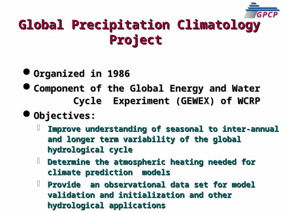
GPCPGPCPGlobal Precipitation Climatology Global Precipitation Climatology
ProjectProject
Organized in 1986 Organized in 1986 Component of the Global Energy and Water Component of the Global Energy and Water
Cycle Experiment (GEWEX) of WCRP Cycle Experiment (GEWEX) of WCRP Objectives: Objectives:
Improve understanding of seasonal to inter-annual Improve understanding of seasonal to inter-annual and longer term variability of the global and longer term variability of the global hydrological cyclehydrological cycle
Determine the atmospheric heating needed for Determine the atmospheric heating needed for climate prediction models climate prediction models
Provide an observational data set for model Provide an observational data set for model validation and initialization and other hydrological validation and initialization and other hydrological applicationsapplications
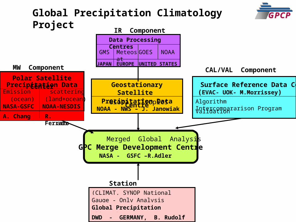
GPCPGPCPGlobal Precipitation Climatology Project
Data Processing Centres
GMS Meteosat GOES NOAA
JAPAN EUROPE UNITED STATES
Geostationary Satellite Precipitation Data Centre
Surface Reference Data Centre scattering
(ocean)
Polar SatellitePrecipitation Data Center
Emission(land+ocean)
NASA-GSFC NOAA-NESDIS
GPC Merge Development CentreMerged Global Analysis
Global TropicsNOAA - NWS – J. Janowiak
NASA - GSFC –R.Adler
MW Component CAL/VAL Component
IR Component
Station Observations(CLIMAT, SYNOP National Collections)Gauge - Only AnalysisGlobal Precipitation Climatology CentreDWD - GERMANY, B. Rudolf
(EVAC- UOK- M.Morrissey)Algorithm Intercompararison ProgramValidation
GPCPGPCP
A. Chang R.FerraroA. Chang R. Ferraro
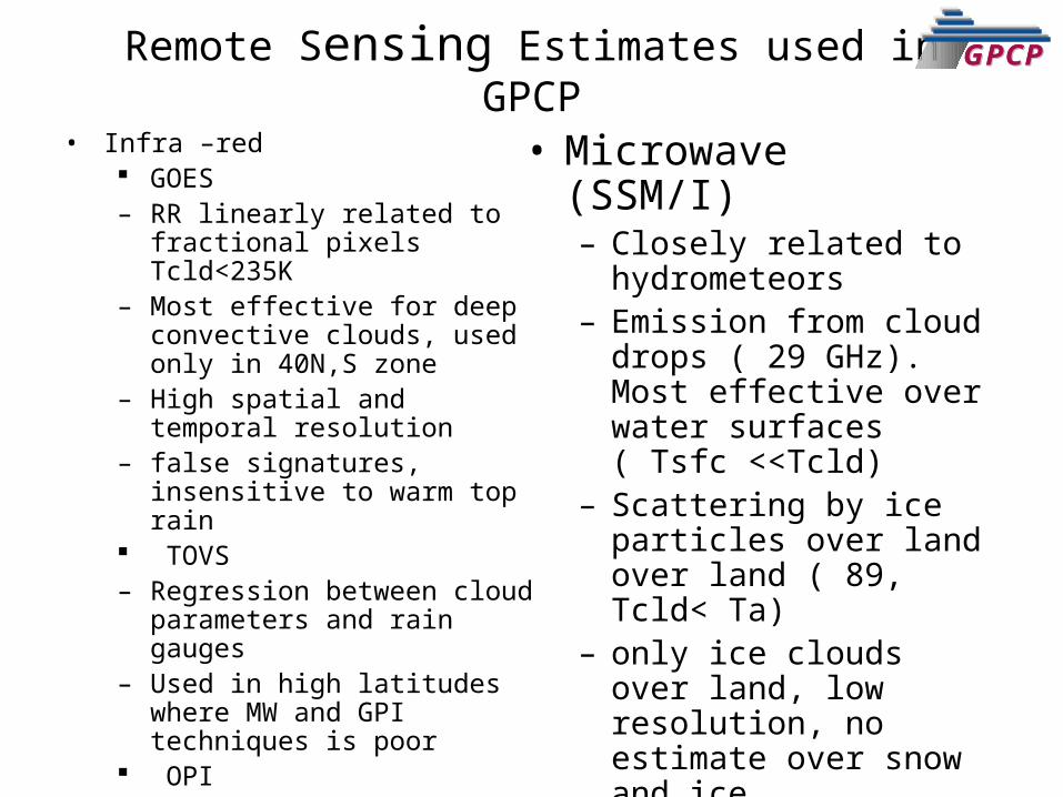
GPCPGPCPRemote Sensing Estimates used in GPCP• Infra –red
GOES – RR linearly related to fractional
pixels Tcld<235K– Most effective for deep convective
clouds, used only in 40N,S zone– High spatial and temporal resolution– false signatures, insensitive to warm
top rain TOVS– Regression between cloud
parameters and rain gauges– Used in high latitudes where MW
and GPI techniques is poor OPI– OLR precipitation Index
• Microwave (SSM/I)– Closely related to
hydrometeors– Emission from cloud drops
( 29 GHz). Most effective over water surfaces ( Tsfc <<Tcld)
– Scattering by ice particles over land over land ( 89, Tcld< Ta)
– only ice clouds over land, low resolution, no estimate over snow and ice
GPCPGPCP
GPCPGPCP
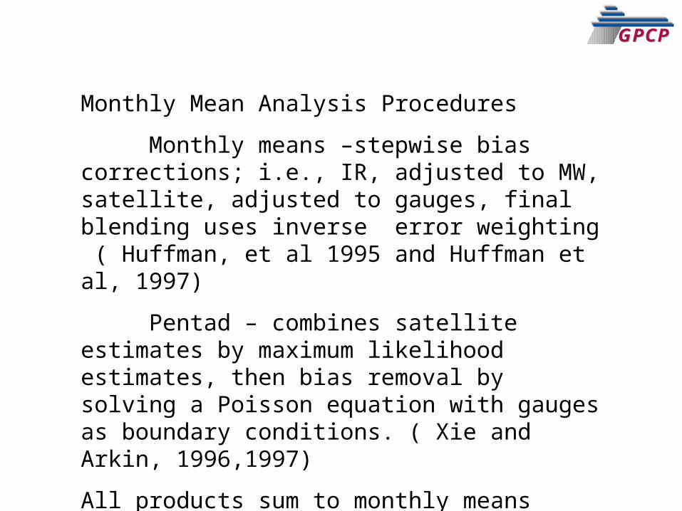
Monthly Mean Analysis Procedures
Monthly means –stepwise bias corrections; i.e., IR, adjusted to MW, satellite, adjusted to gauges, final blending uses inverse error weighting ( Huffman, et al 1995 and Huffman et al, 1997)
Pentad – combines satellite estimates by maximum likelihood estimates, then bias removal by solving a Poisson equation with gauges as boundary conditions. ( Xie and Arkin, 1996,1997)
All products sum to monthly means
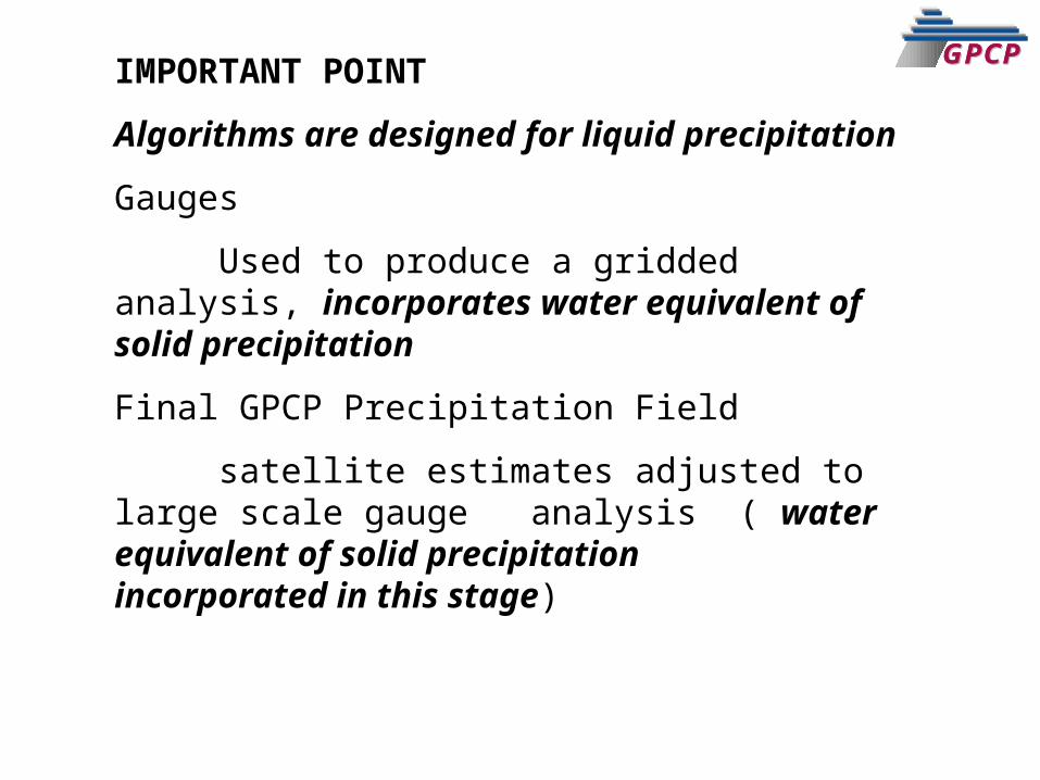
GPCPGPCPIMPORTANT POINT
Algorithms are designed for liquid precipitation
Gauges
Used to produce a gridded analysis, incorporates water equivalent of solid precipitation
Final GPCP Precipitation Field
satellite estimates adjusted to large scale gauge analysis ( water equivalent of solid precipitation incorporated in this stage)
GPCPGPCP
GPCPGPCP
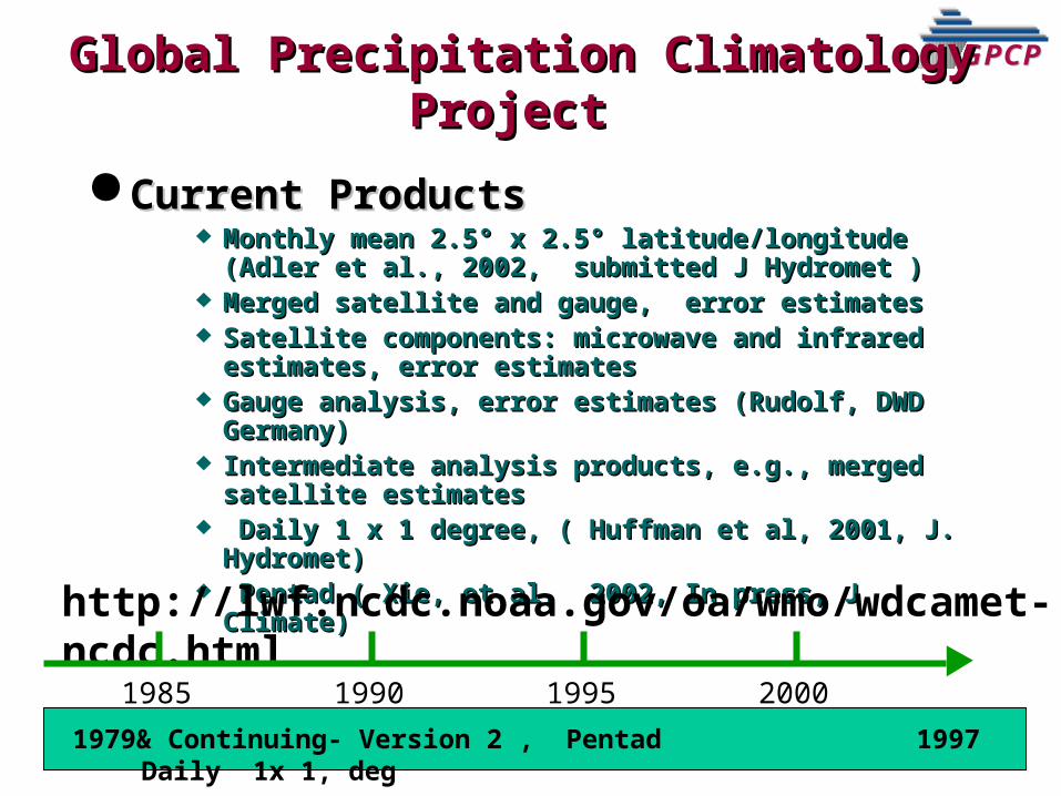
Current ProductsCurrent Products Monthly mean 2.5° x 2.5° latitude/longitude (Adler Monthly mean 2.5° x 2.5° latitude/longitude (Adler
et al., 2002, submitted J Hydromet )et al., 2002, submitted J Hydromet ) Merged satellite and gauge, error estimatesMerged satellite and gauge, error estimates Satellite components: microwave and infrared Satellite components: microwave and infrared
estimates, error estimatesestimates, error estimates Gauge analysis, error estimates (Rudolf, DWD Gauge analysis, error estimates (Rudolf, DWD
Germany)Germany) Intermediate analysis products, e.g., merged Intermediate analysis products, e.g., merged
satellite estimatessatellite estimates Daily 1 x 1 degree, ( Huffman et al, 2001, J. Daily 1 x 1 degree, ( Huffman et al, 2001, J.
Hydromet) Hydromet) Pentad ( Xie, et al, 2002, In press, J Climate)Pentad ( Xie, et al, 2002, In press, J Climate)
Global Precipitation Climatology Global Precipitation Climatology ProjectProject
http://lwf.ncdc.noaa.gov/oa/wmo/wdcamet-ncdc.html
1985 2000199519901979& Continuing- Version 2 , Pentad 1997 Daily 1x 1, deg
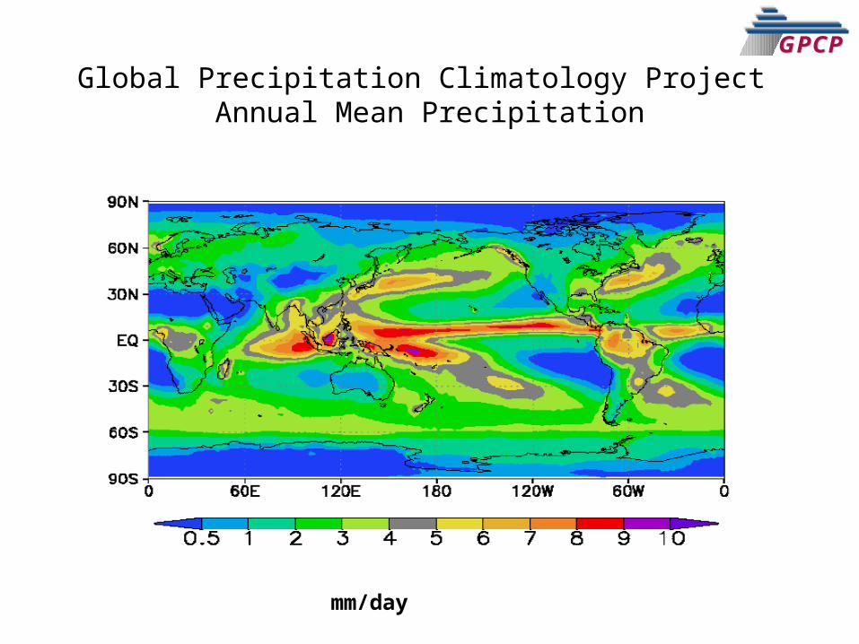
GPCPGPCPGlobal Precipitation Climatology Project
Annual Mean Precipitation
mm/day
GPCPGPCPGPCPGPCP
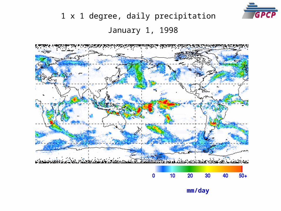
GPCPGPCP1 x 1 degree, daily precipitation January 1, 1998
mm/day
GPCPGPCP
GPCPGPCP
GPCPGPCP
GPCPGPCP
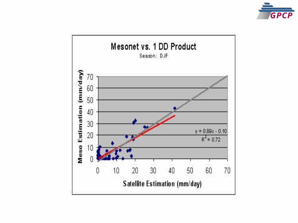
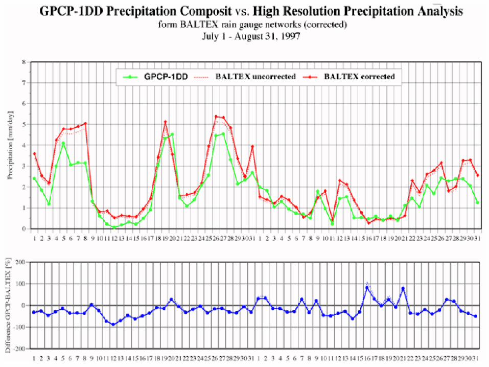
Validation
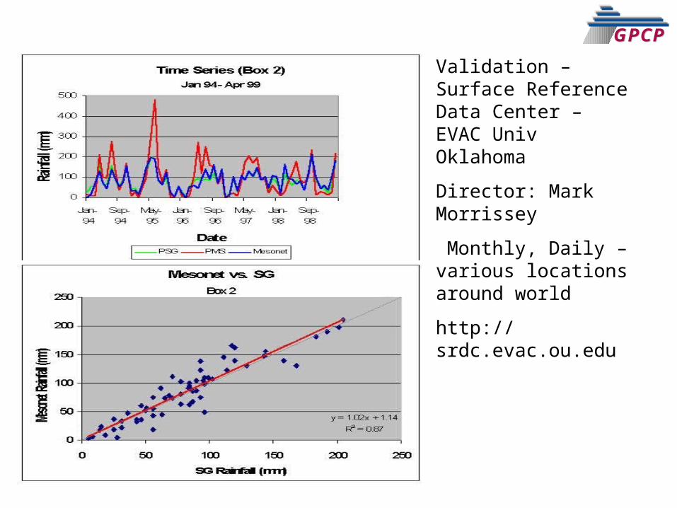
GPCPGPCPValidation –Surface Reference Data Center – EVAC Univ Oklahoma
Director: Mark Morrissey
Monthly, Daily – various locations around world
http://srdc.evac.ou.edu
GPCPGPCP
GPCPGPCP
GPCPGPCP
Applications
GPCPGPCP
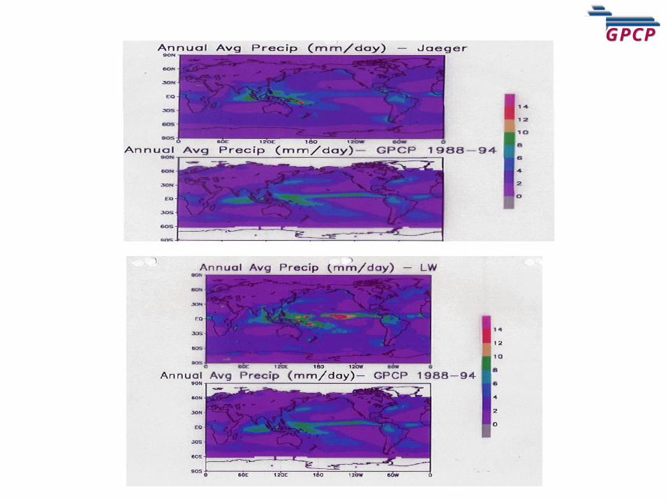
GPCPGPCP
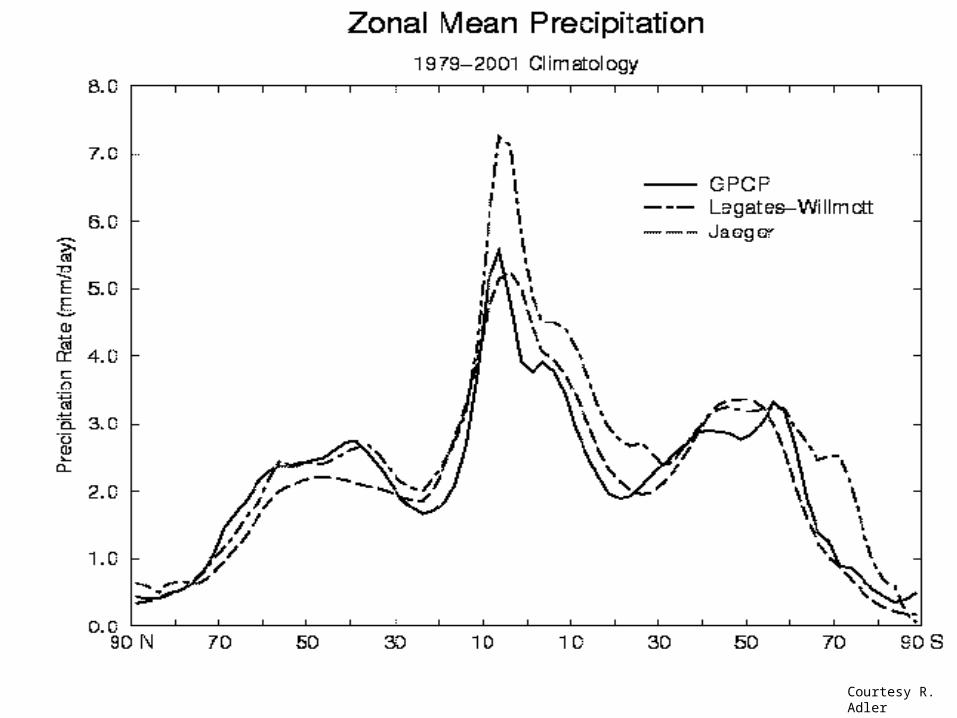
Courtesy R. Adler
GPCPGPCP
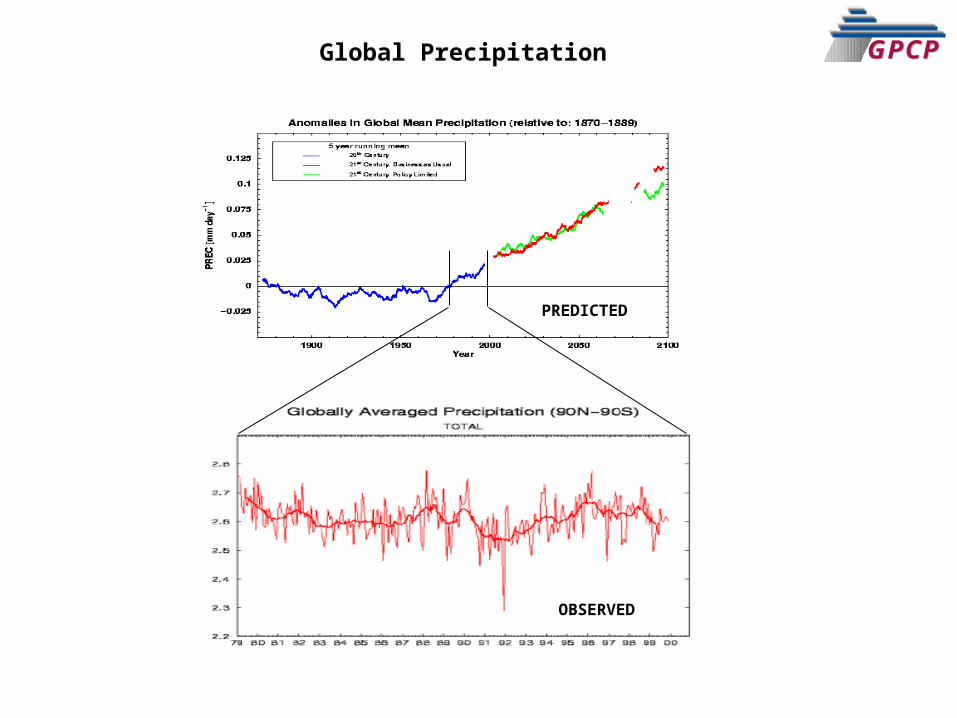
PREDICTED
OBSERVED
Global Precipitation
GPCPGPCP
GPCPGPCP
GPCPGPCP
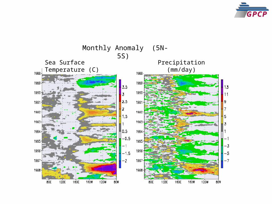
Monthly Anomaly (5N-5S) Sea Surface Temperature (C)
Precipitation (mm/day)
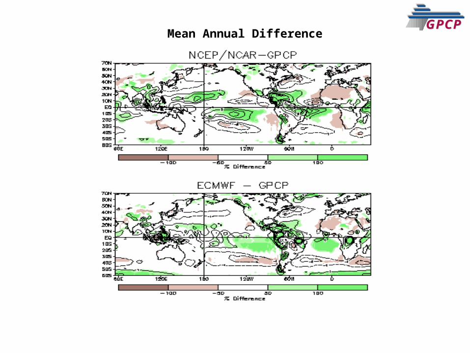
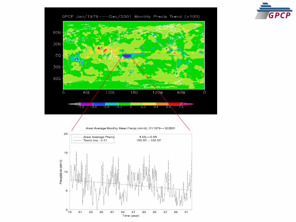
GPCPGPCPMean Annual Difference
GPCPGPCP
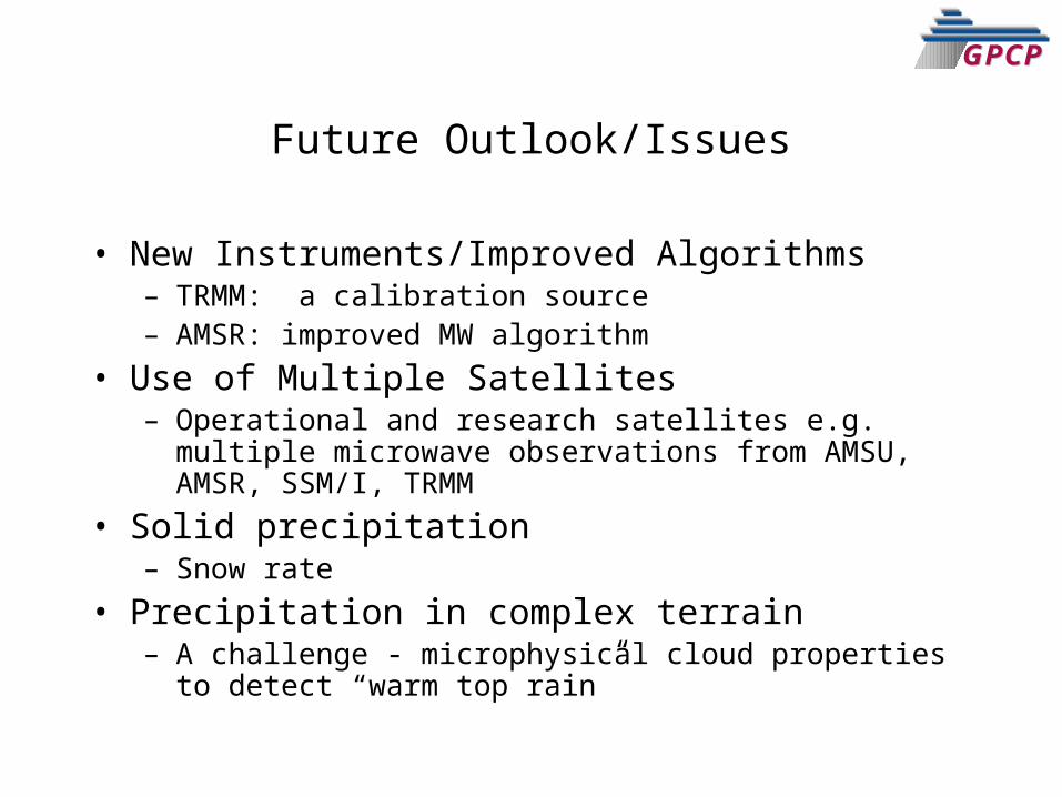
• New Instruments/Improved Algorithms– TRMM: a calibration source– AMSR: improved MW algorithm
• Use of Multiple Satellites– Operational and research satellites e.g. multiple microwave
observations from AMSU, AMSR, SSM/I, TRMM• Solid precipitation
– Snow rate• Precipitation in complex terrain
– A challenge - microphysical cloud properties to detect “warm top rain”
Future Outlook/Issues
GPCPGPCP
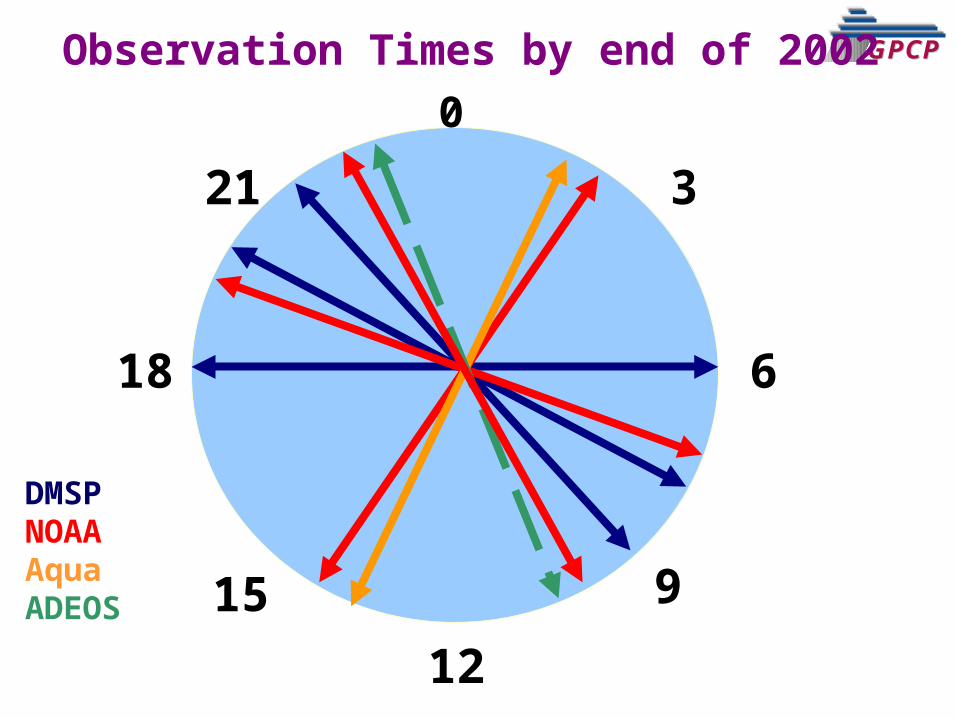
GPCPGPCPObservation Times by end of 20020
6
12
18
915
21 3
DMSPNOAAAquaADEOS
GPCPGPCP
GPCPGPCP
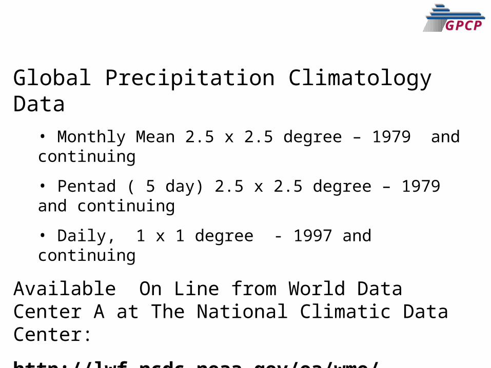
Global Precipitation Climatology Data• Monthly Mean 2.5 x 2.5 degree – 1979 and continuing
• Pentad ( 5 day) 2.5 x 2.5 degree – 1979 and continuing
• Daily, 1 x 1 degree - 1997 and continuing
Available On Line from World Data Center A at The National Climatic Data Center:
http://lwf.ncdc.noaa.gov/oa/wmo/wdcamet-ncdc.html


