In late March of 1913 rain fell in such an excess over the Ohio Valley that no river in Ohio and most of Indiana remained in it’s banks. Bridges, road, railways, dams, and property were washed away. In its wake an at least 600 people had drowned, a quarter million people were leG homeless, and damages were esHmated in the hundreds of millions making it at that Hme the largest natural disaster the United States had witnessed. A few years before the Great Floods of March 1913, Andrew Carnegie was quoted as predic?on “the Ohio Valley will become the workshop of the world; the present commerce of the river is so immense.” Around the ?me of the Great Flood the Ohio Valley popula?on was an es?mated 21,700,000 people, or one quarter of the na?on’s total popula?on. Also during this ?me the region was the largest producer of the na?on’s coal, iron, and natural. The amount of manufacturing being produced and shipped in and out of the Ohio Valley was unprecedented. On Easter Sunday of 1913 the beginning of a series of storms moved out of the Rockies and into the Ohio Valley. This began the onset of four straight days of rain and historic flooding. For the first ?me a natural disaster in one part of the country had an instant effect across the en?re na?on. The damage to roads, railways, telephone and electrical lines paralyzed commerce in and out of the region. As a result, there was na?onal outcry for state and federal governments to reevaluate their role in flood control. Some local communi?es couldn’t wait for state and federal help. In southwest Ohio, people of the Miami Valley began the technical and poli?cal process to prevent future flooding. This and future floods con?nued to expand the na?ons interest and investments into flood control. Today those in emergency response realize the how cri?cal flood awareness and preparedness can be in reducing our threat to life and property in the face of future floods. “The people of the Miami Valley learned through the flood to do effecHve team work and to share their resources in furthering common interests.” A senHment made by the Miami Conservancy District in 1917 and shared by the modern day Silver Jackets. The Great Flood of 1913 100 Years Later Paddlers in downtown Youngstown on March 26, 1913 (above) and a failed railway track between Wooster and Millbrook Ohio (below). Photos from “Pennsylvania Lines West of Pi^sburgh: A History of the Flood of March, 1913” by Charles W. Garre^ h^p://mrcc.isws.illinois.edu/1913Flood/
Transcript
In late March of 1913 rain fell in such an excess over the Ohio Valley that no river in Ohio and most of Indiana remained in it’s banks. Bridges, road, railways, dams, and property were washed away. In its wake an at least 600 people had drowned, a quarter million people were leG homeless, and damages were esHmated in the hundreds of millions making it at that Hme the largest natural disaster the United States had witnessed. A few years before the Great Floods of March 1913, Andrew Carnegie was quoted as predic?on “the Ohio Valley will become the workshop of the world; the present commerce of the river is so immense.” Around the ?me of the Great Flood the Ohio Valley popula?on was an es?mated 21,700,000 people, or one quarter of the na?on’s total popula?on. Also during this ?me the region was the largest producer of the na?on’s coal, iron, and natural. The amount of manufacturing being produced and shipped in and out of the Ohio Valley was unprecedented. On Easter Sunday of 1913 the beginning of a series of storms moved out of the Rockies and into the Ohio Valley. This began the onset of four straight days of rain and historic flooding. For the first ?me a natural disaster in one part of the country had an instant effect across the en?re na?on. The damage to roads, railways, telephone and electrical lines paralyzed commerce in and out of the region. As a result, there was na?onal outcry for state and federal governments to reevaluate their role in flood control. Some local communi?es couldn’t wait for state and federal help. In southwest Ohio, people of the Miami Valley began the technical and poli?cal process to prevent future flooding. This and future floods con?nued to expand the na?ons interest and investments into flood control. Today those in emergency response realize the how cri?cal flood awareness and preparedness can be in reducing our threat to life and property in the face of future floods.
“The people of the Miami Valley learned through the flood to do effecHve team work and to share their resources in furthering common interests.” A senHment made by the Miami Conservancy District in 1917 and shared by the modern day Silver Jackets.
The Great Flood of 1913
100 Years Later
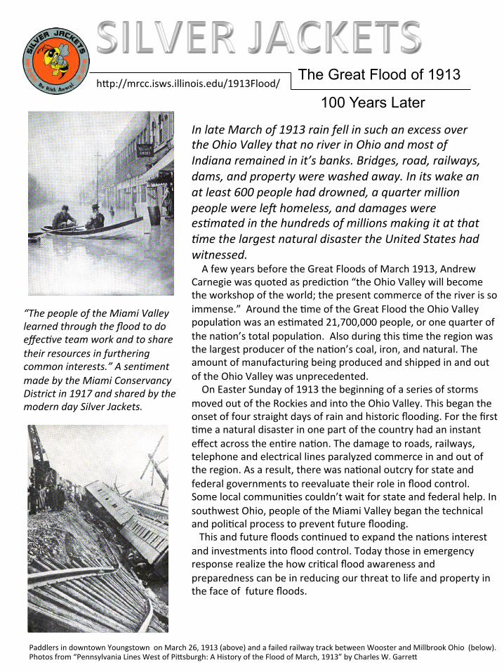
Paddlers in downtown Youngstown on March 26, 1913 (above) and a failed railway track between Wooster and Millbrook Ohio (below). Photos from “Pennsylvania Lines West of Pi^sburgh: A History of the Flood of March, 1913” by Charles W. Garre^
h^p://mrcc.isws.illinois.edu/1913Flood/
Silver Jackets…Remember the Flood of 1913
The torren?al rains from March 23‐27th over the Ohio Valley produced a flood of rare magnitude and destruc?ve force. The Ohio Valley was no stranger to flooding with floods occurring on a nearly regular basis, especially in spring. However this event was unprecedented in it’s dura?on and the severity of the damage in its wake. Levees and dams failed under the immense pressure of so much water. Prior to the Great Flood many towns in the Ohio Valley had some form of flood protec?on such as levees or floodwalls. These proved severely insufficient with floodwaters of the magnitude observed that March. Hundreds of flood protec?on measures failed, surprising residents who believed they were safe. The devasta?on was too much for most local communi?es to handle. With limited warnings available from upstream, there was ofen li^le ?me to prepare. When alerted to poten?al flooding, communi?es would ofen try sandbagging. If that failed, evacua?on was the last recourse. Most informa?on regarding flooding came from monitoring river staff gauges and reports from upstream. The heavy rains in March 1913 made it clear flooding was immanent, to what severity was anyone's guess. The Weather Bureau of 1913 was able to send word to some of the hardest hit communi?es about the flood threat, but with downed telephone lines from previous severe storms most communica?on was limited.
At the state level the capitals of Ohio and Indiana were underwater which slowed rescue and recovery efforts to the rest of the state. Telephone and power lines were down, limi?ng the ability to relay accurate informa?on or for pleas of help to reach poten?al rescuers. Trains were halted or marooned, and bridges and roads were washed out in mul?‐states limi?ng the movement of resources. To avoid looters and chaos mar?al law was issued in several towns. Despite the immense challenges at the ?me, there are thousands of accounts of neighbors helping neighbors, and towns helping towns. Heroic stories were reported by the hundreds. However many ci?zens perished in a^empts to cross swif waters during rescue a^empts.
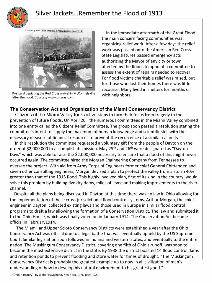
The Columbus fire department helped save many stranded people. NOAA photo library.
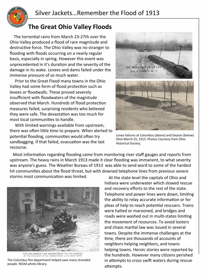
Levee failures at Columbus (above) and Dayton (below) Ohio March 25, 1913. Photos Courtesy from Ohio Historical Society.
The Great Ohio Valley Floods
Silver Jackets…Remember the Flood of 1913
In the immediate afermath of the Great Flood the main concern facing communi?es was organizing relief work. Afer a few days the relief work was passed onto the American Red Cross. State Legislatures passed emergency acts authorizing the Mayor of any city or town affected by the floods to appoint a commi^ee to assess the extent of repairs needed to recover. For flood vic?ms charitable relief was raised, but for those who lost their homes there was li^le recourse. Many lived in shelters for months or with neighbors.
The Conservation Act and Organization of the Miami Conservancy District Citizens of the Miami Valley took active steps to turn their focus from tragedy to the preven?on of future floods. On April 20th the numerous commi^ees in the Miami Valley combined into one en?ty called the Ci?zens Relief Commi^ee. The group soon passed a resolu?on sta?ng the commi^ee’s intent to “apply the maximum of human knowledge and scien?fic skill with the necessary measure of financial resources to prevent the recurrence of a similar calamity.” In this resolu?on the commi^ee requested a voluntary gif from the people of Dayton on the order of $2,000,000 to accomplish its mission. May 25th and 26th were designated as “Dayton Days” which was able to raise the $2,000,000 necessary to ensure that a flood of this might never occurred again. The commi^ee hired the Morgan Engineering Company from Tennessee to oversee the project. With aid from Army Corps of Engineers former chief General Chi^enden and seven other consul?ng engineers, Morgan devised a plan to protect the valley from a storm 40% greater than that of the 1913 flood. This highly involved plan, first of its kind in the country, would solve this problem by building five dry dams, miles of levee and making improvements to the river channel. Despite all the plans being discussed in Dayton at this ?me there was no law in Ohio allowing for the implementa?on of these cross‐jurisdic?onal flood control systems. Arthur Morgan, the chief engineer in Dayton, collected exis?ng laws and those used in Europe in similar flood control programs to draf a law allowing the forma?on of a Conserva?on District. The law and submi^ed it to the Ohio House, which was finally voted on in January 1914. The Conserva?on Act became official in February1914. The Miami and Upper Scioto Conservancy Districts were established a year afer the Ohio Conservancy Act was official due to a legal ba^le that was eventually upheld by the US Supreme Court. Similar legisla?on soon followed in Indiana and western states, and eventually to the en?re na?on. The Muskingum Conservancy District, covering one fifh of Ohio’s runoff, was soon to become the most extensive district in the state. By 1938 the district boasted 14 flood control dams and reten?on ponds to prevent flooding and store water for ?mes of drought. “The Muskingum Conservancy District is probably the greatest example up to now in all civiliza?on of man’s understanding of how to develop his natural environment to his greatest good.”1
1 “Ohio‐A History”, by Walter Havighurst, New York, 1976, page 192.
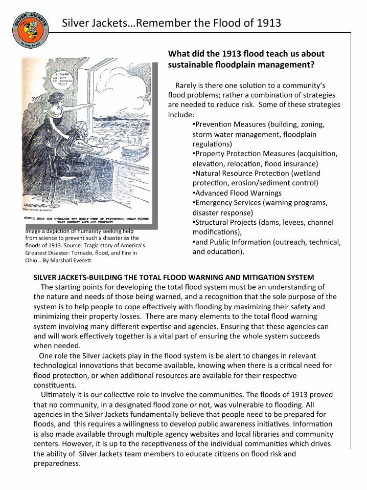
Postcard depic?ng the Red Cross arrival in McConnelsville afer the flood. Courtesy www.brisray.com
What did the 1913 flood teach us about sustainable floodplain management? Rarely is there one solu?on to a community’s flood problems; rather a combina?on of strategies are needed to reduce risk. Some of these strategies include:
Image a depic?on of humanity seeking help from science to prevent such a disaster as the floods of 1913. Source: Tragic story of America’s Greatest Disaster: Tornado, flood, and Fire in Ohio… By Marshall Evere^
SILVER JACKETS‐BUILDING THE TOTAL FLOOD WARNING AND MITIGATION SYSTEM The star?ng points for developing the total flood system must be an understanding of the nature and needs of those being warned, and a recogni?on that the sole purpose of the system is to help people to cope effec?vely with flooding by maximizing their safety and minimizing their property losses. There are many elements to the total flood warning system involving many different exper?se and agencies. Ensuring that these agencies can and will work effec?vely together is a vital part of ensuring the whole system succeeds when needed. One role the Silver Jackets play in the flood system is be alert to changes in relevant technological innova?ons that become available, knowing when there is a cri?cal need for flood protec?on, or when addi?onal resources are available for their respec?ve cons?tuents. Ul?mately it is our collec?ve role to involve the communi?es. The floods of 1913 proved that no community, in a designated flood zone or not, was vulnerable to flooding. All agencies in the Silver Jackets fundamentally believe that people need to be prepared for floods, and this requires a willingness to develop public awareness ini?a?ves. Informa?on is also made available through mul?ple agency websites and local libraries and community centers. However, it is up to the recep?veness of the individual communi?es which drives the ability of Silver Jackets team members to educate ci?zens on flood risk and preparedness.
Silver Jackets…Remember the Flood of 1913
2013‐100 Years of Flood Services
How do we prepare for floods? Flood control and mi?ga?on prior to flood seasons can greatly reduce or prevent the impacts of flooding. Some significant changes that can be done included:
• construc?ng levees, flood bypasses, channel improvements, deten?on basins and flood mi?ga?on dams, • ins?tu?ng land use controls (such as zoning and the removal of exis?ng buildings) and building restric?ons (such as establishing minimum floor levels and raising buildings) in rela?on to development on flood‐prone land, • developing local flood warning systems, • developing response and recovery capabili?es, • evaluate your communi?es risk, FEMA Flood Maps and Flood Insurance Studies, • and encouraging flood awareness in the community and the means by which people can manage it.
While these measures rarely remove the flood risk en?rely, they can reduce the impact of floodwaters in ways that enable communi?es to cope be^er when flooding occurs. State and local officials prepare for floods through flood emergency planning, conduc?ng exercises, and educa?ng communi?es on their personal flood risk. Such steps as preparing flood emergency checklists can go a long way in minimizing the risk of lost ?me, property, or even life when flooding occurs.
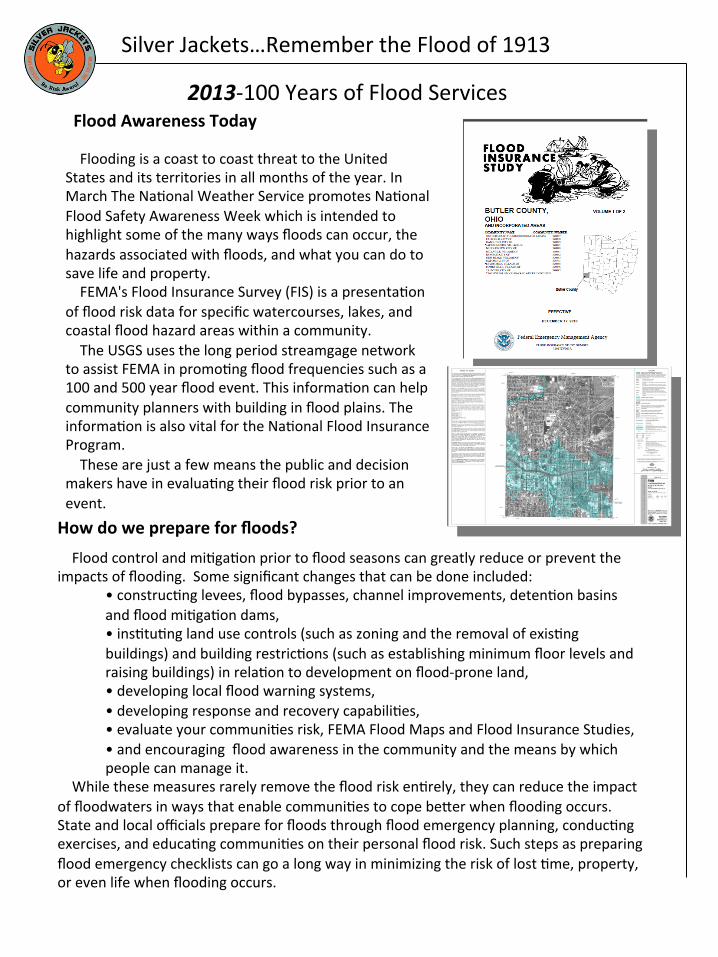
Flood Awareness Today Flooding is a coast to coast threat to the United States and its territories in all months of the year. In March The Na?onal Weather Service promotes Na?onal Flood Safety Awareness Week which is intended to highlight some of the many ways floods can occur, the hazards associated with floods, and what you can do to save life and property. FEMA's Flood Insurance Survey (FIS) is a presenta?on of flood risk data for specific watercourses, lakes, and coastal flood hazard areas within a community. The USGS uses the long period streamgage network to assist FEMA in promo?ng flood frequencies such as a 100 and 500 year flood event. This informa?on can help community planners with building in flood plains. The informa?on is also vital for the Na?onal Flood Insurance Program. These are just a few means the public and decision makers have in evalua?ng their flood risk prior to an event.
Silver Jackets…Remember the Flood of 1913
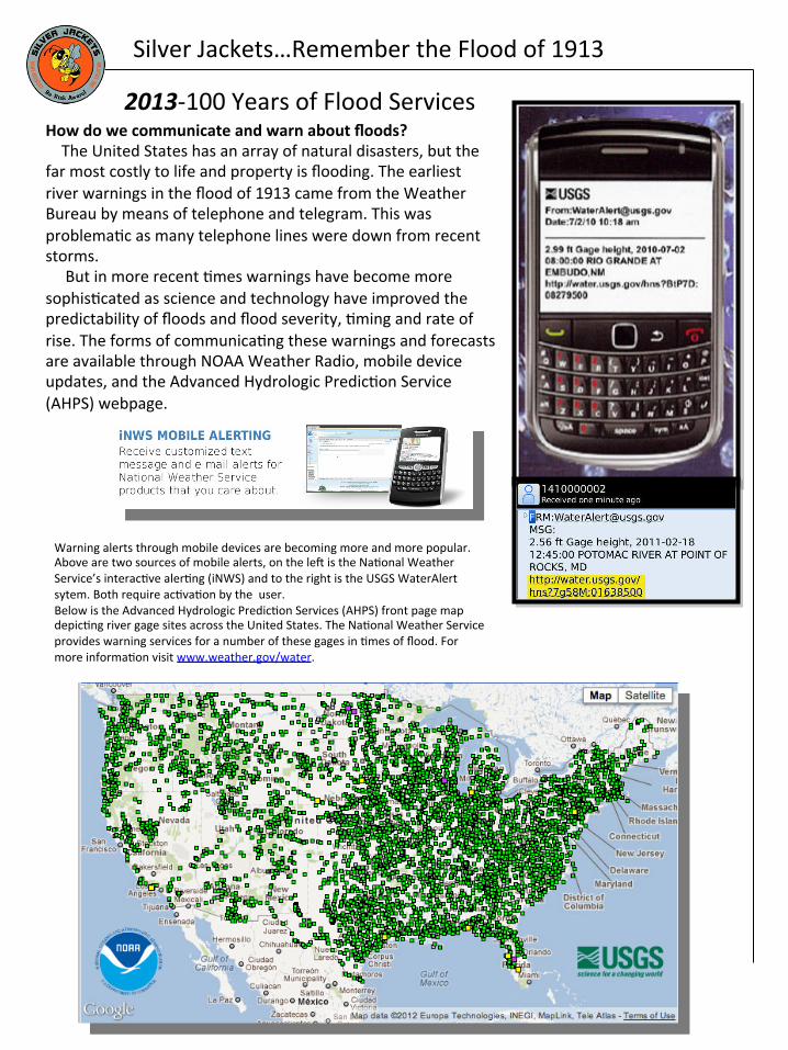
Warning alerts through mobile devices are becoming more and more popular. Above are two sources of mobile alerts, on the lef is the Na?onal Weather Service’s interac?ve aler?ng (iNWS) and to the right is the USGS WaterAlert sytem. Both require ac?va?on by the user. Below is the Advanced Hydrologic Predic?on Services (AHPS) front page map depic?ng river gage sites across the United States. The Na?onal Weather Service provides warning services for a number of these gages in ?mes of flood. For more informa?on visit www.weather.gov/water.
How do we communicate and warn about floods? The United States has an array of natural disasters, but the far most costly to life and property is flooding. The earliest river warnings in the flood of 1913 came from the Weather Bureau by means of telephone and telegram. This was problema?c as many telephone lines were down from recent storms. But in more recent ?mes warnings have become more sophis?cated as science and technology have improved the predictability of floods and flood severity, ?ming and rate of rise. The forms of communica?ng these warnings and forecasts are available through NOAA Weather Radio, mobile device updates, and the Advanced Hydrologic Predic?on Service (AHPS) webpage.
2013‐100 Years of Flood Services
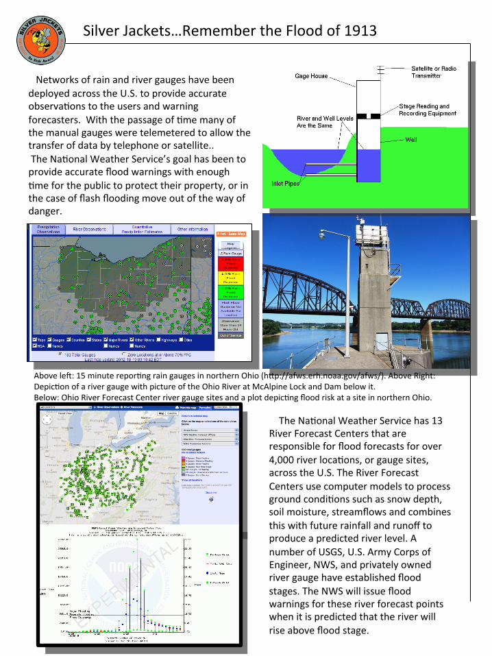
Silver Jackets…Remember the Flood of 1913 Networks of rain and river gauges have been deployed across the U.S. to provide accurate observa?ons to the users and warning forecasters. With the passage of ?me many of the manual gauges were telemetered to allow the transfer of data by telephone or satellite.. The Na?onal Weather Service’s goal has been to provide accurate flood warnings with enough ?me for the public to protect their property, or in the case of flash flooding move out of the way of danger.
Above lef: 15 minute repor?ng rain gauges in northern Ohio (h^p://afws.erh.noaa.gov/afws/). Above Right: Depic?on of a river gauge with picture of the Ohio River at McAlpine Lock and Dam below it. Below: Ohio River Forecast Center river gauge sites and a plot depic?ng flood risk at a site in northern Ohio.
The Na?onal Weather Service has 13 River Forecast Centers that are responsible for flood forecasts for over 4,000 river loca?ons, or gauge sites, across the U.S. The River Forecast Centers use computer models to process ground condi?ons such as snow depth, soil moisture, streamflows and combines this with future rainfall and runoff to produce a predicted river level. A number of USGS, U.S. Army Corps of Engineer, NWS, and privately owned river gauge have established flood stages. The NWS will issue flood warnings for these river forecast points when it is predicted that the river will rise above flood stage.
Silver Jackets…Remember the Flood of 1913
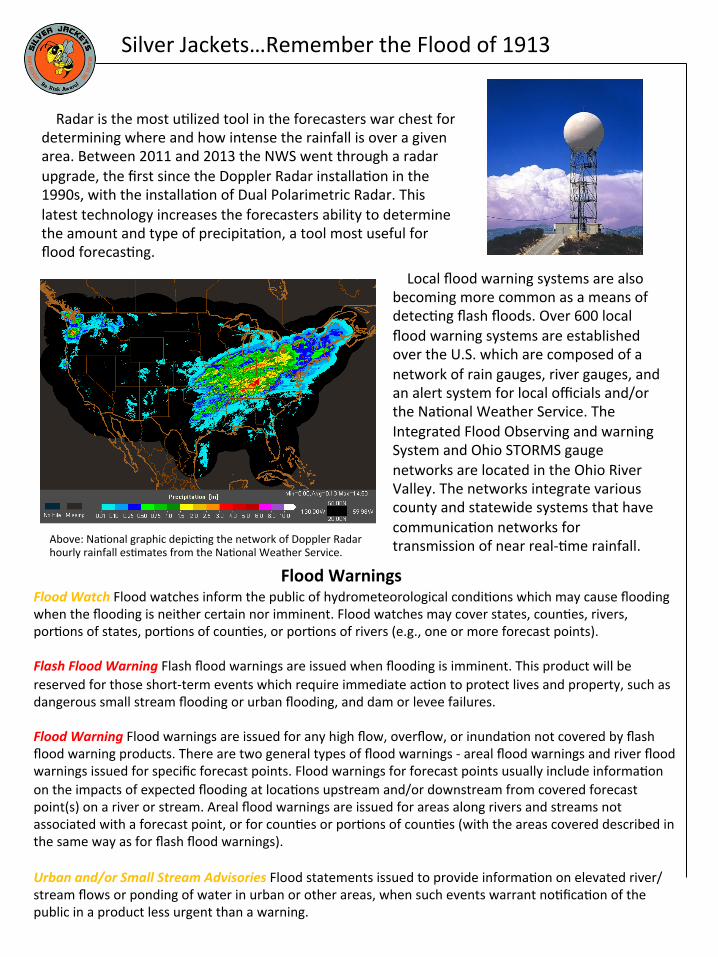
Radar is the most u?lized tool in the forecasters war chest for determining where and how intense the rainfall is over a given area. Between 2011 and 2013 the NWS went through a radar upgrade, the first since the Doppler Radar installa?on in the 1990s, with the installa?on of Dual Polarimetric Radar. This latest technology increases the forecasters ability to determine the amount and type of precipita?on, a tool most useful for flood forecas?ng. Local flood warning systems are also
becoming more common as a means of detec?ng flash floods. Over 600 local flood warning systems are established over the U.S. which are composed of a network of rain gauges, river gauges, and an alert system for local officials and/or the Na?onal Weather Service. The Integrated Flood Observing and warning System and Ohio STORMS gauge networks are located in the Ohio River Valley. The networks integrate various county and statewide systems that have communica?on networks for transmission of near real‐?me rainfall. Above: Na?onal graphic depic?ng the network of Doppler Radar
hourly rainfall es?mates from the Na?onal Weather Service.
Flood Warnings Flood Watch Flood watches inform the public of hydrometeorological condi?ons which may cause flooding
when the flooding is neither certain nor imminent. Flood watches may cover states, coun?es, rivers, por?ons of states, por?ons of coun?es, or por?ons of rivers (e.g., one or more forecast points). Flash Flood Warning Flash flood warnings are issued when flooding is imminent. This product will be reserved for those short‐term events which require immediate ac?on to protect lives and property, such as dangerous small stream flooding or urban flooding, and dam or levee failures. Flood Warning Flood warnings are issued for any high flow, overflow, or inunda?on not covered by flash flood warning products. There are two general types of flood warnings ‐ areal flood warnings and river flood warnings issued for specific forecast points. Flood warnings for forecast points usually include informa?on on the impacts of expected flooding at loca?ons upstream and/or downstream from covered forecast point(s) on a river or stream. Areal flood warnings are issued for areas along rivers and streams not associated with a forecast point, or for coun?es or por?ons of coun?es (with the areas covered described in the same way as for flash flood warnings). Urban and/or Small Stream Advisories Flood statements issued to provide informa?on on elevated river/stream flows or ponding of water in urban or other areas, when such events warrant no?fica?on of the public in a product less urgent than a warning.
Silver Jackets…Remember the Flood of 1913
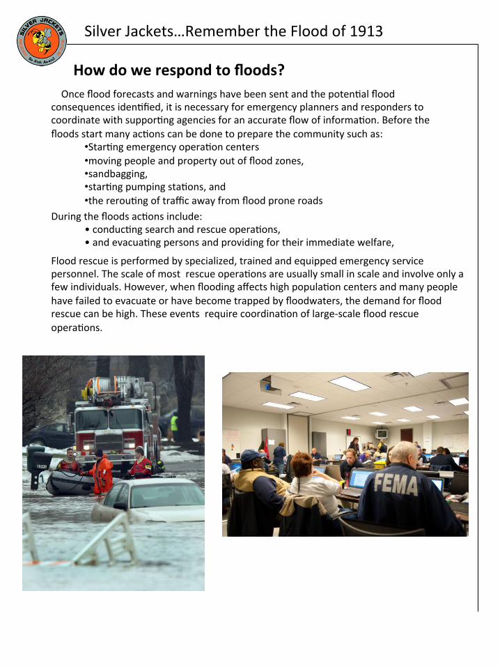
How do we respond to floods?
During the floods ac?ons include: • conduc?ng search and rescue opera?ons, • and evacua?ng persons and providing for their immediate welfare,
Once flood forecasts and warnings have been sent and the poten?al flood consequences iden?fied, it is necessary for emergency planners and responders to coordinate with suppor?ng agencies for an accurate flow of informa?on. Before the floods start many ac?ons can be done to prepare the community such as:
• Star?ng emergency opera?on centers • moving people and property out of flood zones, • sandbagging, • star?ng pumping sta?ons, and • the rerou?ng of traffic away from flood prone roads
Flood rescue is performed by specialized, trained and equipped emergency service personnel. The scale of most rescue opera?ons are usually small in scale and involve only a few individuals. However, when flooding affects high popula?on centers and many people have failed to evacuate or have become trapped by floodwaters, the demand for flood rescue can be high. These events require coordina?on of large‐scale flood rescue opera?ons.
Silver Jackets…Remember the Flood of 1913
How do we recover from floods?
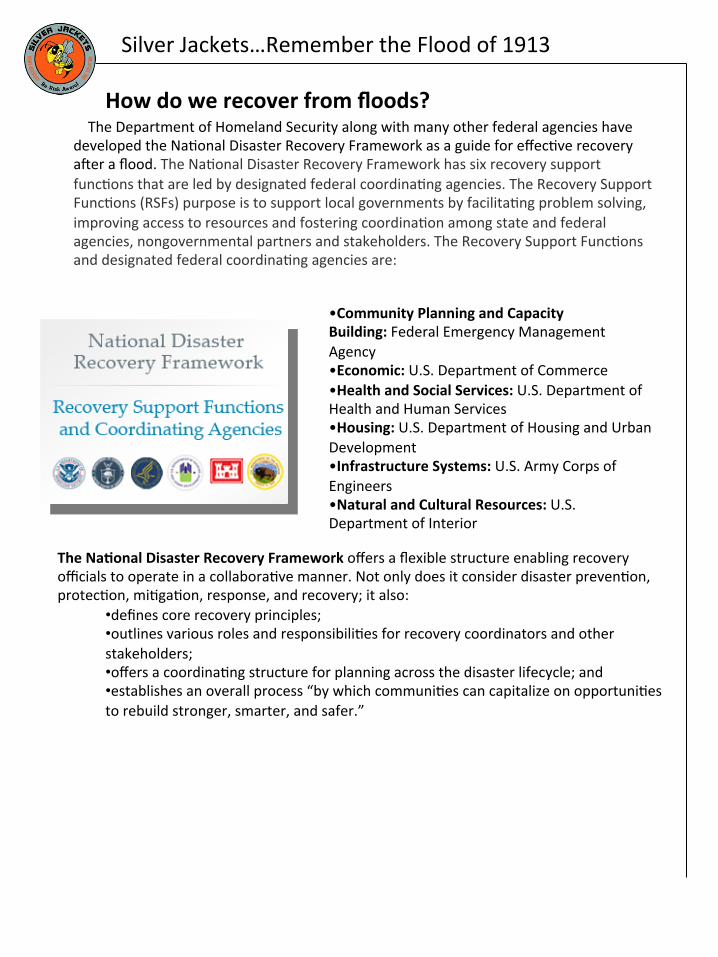
The Department of Homeland Security along with many other federal agencies have developed the Na?onal Disaster Recovery Framework as a guide for effec?ve recovery afer a flood. The Na?onal Disaster Recovery Framework has six recovery support func?ons that are led by designated federal coordina?ng agencies. The Recovery Support Func?ons (RSFs) purpose is to support local governments by facilita?ng problem solving, improving access to resources and fostering coordina?on among state and federal agencies, nongovernmental partners and stakeholders. The Recovery Support Func?ons and designated federal coordina?ng agencies are:
• Community Planning and Capacity Building: Federal Emergency Management Agency • Economic: U.S. Department of Commerce • Health and Social Services: U.S. Department of Health and Human Services • Housing: U.S. Department of Housing and Urban Development • Infrastructure Systems: U.S. Army Corps of Engineers • Natural and Cultural Resources: U.S. Department of Interior
The NaUonal Disaster Recovery Framework offers a flexible structure enabling recovery officials to operate in a collabora?ve manner. Not only does it consider disaster preven?on, protec?on, mi?ga?on, response, and recovery; it also:
• defines core recovery principles; • outlines various roles and responsibili?es for recovery coordinators and other stakeholders; • offers a coordina?ng structure for planning across the disaster lifecycle; and • establishes an overall process “by which communi?es can capitalize on opportuni?es to rebuild stronger, smarter, and safer.”
Silver Jackets…Remember the Flood of 1913
The earliest flood control systems in the Ohio Valley were those implemented by private or local interests. Recovery from flood disasters was the primary role of the American Red Cross and other charitable organiza?ons,. Due to the staggering extent of damage the Great Flood lef in its wake, it led to an era of flood awareness. New local, state, and federal agencies worked to develop programs that would help prevent or limit the impacts from this type of flood in the future.
Afer the flood of 1913 local ci?zens and those from the federal government began to push for more comprehensive flood preven?on. Though there is no way of preven?ng the rain from coming, there are many means of limi?ng the extent of the damage. However many of these methods come with large price tags, too significant for many smaller communi?es to afford.
The Miami Conservancy District, followed soon by several more so inspired Conservancy Districts across Ohio and Indiana, completed an unprecedented flood control system to protect their ci?zens from future floods. The Federal government saw that each dollar spent on flood protec?on saved future flood relief dollars. Shortly afer the 1913 flood the federal government became interested in funding flood control projects. The legisla?on lagged in Washington however other significant floods, most notably the Mississippi Flood of 1917, drove the policies through. As a result, more state and federal agencies across the country became invested in the mission to protect life and property against floods.
In the one hundred years since the Great Flood of 1913 there have been great strides in reducing the threat to life and property from floods. Some of these strategies include:
• Preven?on measures (building, zoning, storm water management, floodplain regula?ons)
• Property protec?on measures (acquisi?on, eleva?on, reloca?on, flood insurance) • Natural resource protec?on (wetland protec?on, erosion/sediment control) • Emergency services (warning programs, disaster response) • Structural projects (dams, levees, channel modifica?ons) • Public informa?on (outreach, technical assistance, educa?on) • Flood Warnings and alerts It has been learned ?me and ?me again that it is through a combina?on of these efforts
that the loss of life and property can be greatly reduced in future floods. The authority to implement these strategies is spread across various government agencies, the private sector, non‐profits, academia, etc. The collabora?on of many of these agencies into the Silver Jackets teams will help reduce impact from future floods. Arthur Morgan of the Miami Conservancy District knew that there is more than one solu?on to a community’s flood problems. In order to know where you are going, you must know where you have been. Understanding and learning from past floods will help this country con?nue to improve our abili?es to protect life and property the next ?me the waters rise.
Summary
Sarah Jamison NaHonal Weather Service ‐Service Hydrologist And Ohio and Pennsylvania Silver Jackets Member


![[1913] #2.12 Armour's Monthly Cook Book - October 1913](https://static.documents.pub/doc/80x56/577d2da61a28ab4e1eae0102/1913-212-armours-monthly-cook-book-october-1913.jpg)


