78
The Gulf of Mannar and its surroundings A resource book for teachers in the Mannar District
The Gulf of Mannar and its surroundings
A resource book for teachers in the Mannar District

The Gulf of Mannar and its surroundings
A resource book for teachers in the Mannar District

Through Doric Bungalow(Sampath Goonatilake © IUCN)
The Gulf of Mannar and its surroundings
A resource book for teachers in the Mannar District
Compiled by
Dr Sriyanie Miththapala
iv
Published by : IUCN (International Union for Conservation of Nature), SriLankaOffice.
Copyright : © 2012 IUCN, International Union for Conservation of Nature andNaturalResources.
Reproductionofthispublicationforeducationalorothernon-commercialpurposesisauthorizedwithoutpriorwrittenpermissionfromthecopyrightholderprovidedthesourceisfullyacknowledged.
Reproductionofthispublicationforanycommercialpurposesisprohibitedwithoutpriorwrittenpermissionofthecopyrightholder.
Citation : Miththapala,Sriyanie(2012).TheGulfofMannaranditssurroundings:AresourcebookforteachersintheMannarDistrict.IUCNSriLankaOffice,Colombo.x+64pp.
ISBN : 978-955-0205-14-1
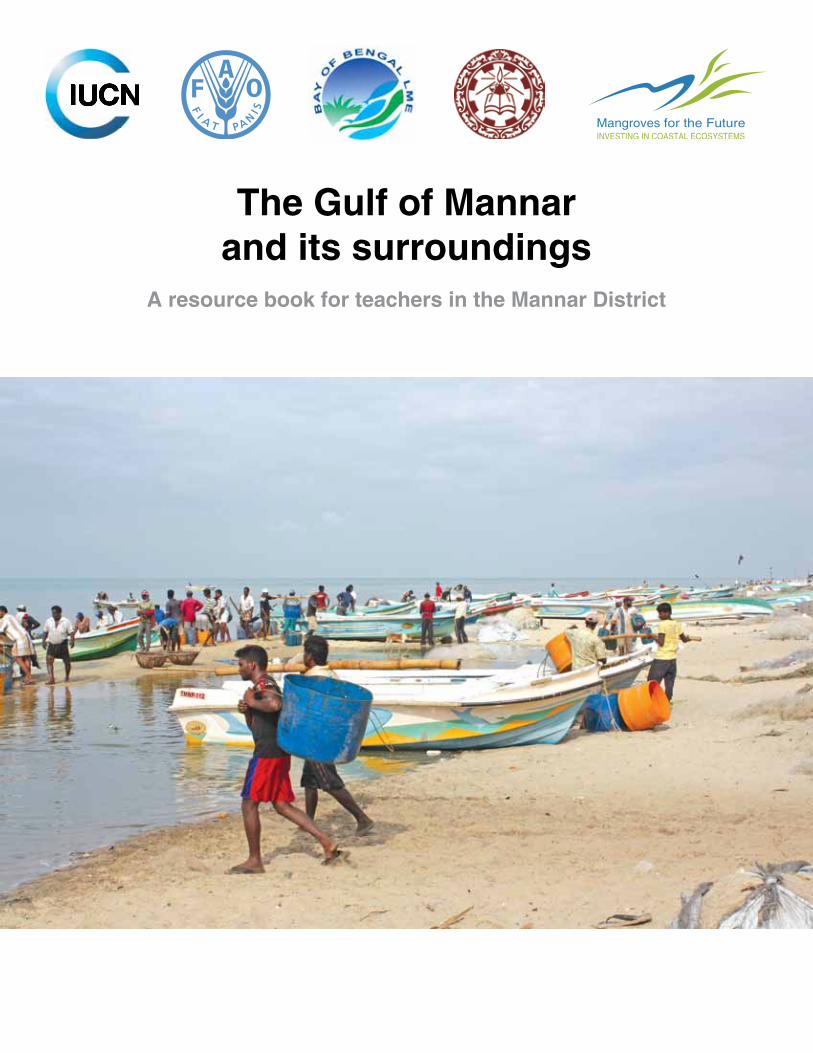
Cover Photograph : Fish Landing site at Pesalai (Shamen Vidanage © IUCN)
Designedby : PadmiMeegoda Producedby : IUCNSriLankaOffice
Available from : IUCN SriLankaCountryOffice, 53,HortonPlace, Colombo 07, SriLanka. www.iucnsl.org
Printedby : Karunaratne&Sons(Pvt)Ltd.,67,UDAIndustrialEstate, KatuwanaRoad,Homagama,SriLanka.www.karusons.com
PrintedwithVOCfree,nontoxicvegetableoil-based environmentally-friendlyink,onchlorinefreepapermadefrom60%
sugarcanefibreandwoodpulpfromsustainableafforestation.
v
CONTENTS
Message from the Director General, NIE -------------------------------------------------------------------------------viii
Acknowledgements -----------------------------------------------------------------------------------------------------------ix
Chapter 1 - Gulf of Mannar: The Setting --------------------------------------------------------------------------------- 11.1 WhereistheGulfofMannar?----------------------------------------------------------------------------------------- 11.2 TheclimateintheGulfofMannar------------------------------------------------------------------------------------ 21.3 RiversandLagoonsinarea-------------------------------------------------------------------------------------------- 41.4 TheSriLankancoastlineintheregionoftheGulfofMannar------------------------------------------------- 61.5 Thepeopleofthearea--------------------------------------------------------------------------------------------------- 61.6 WhatdothepeopleofMannardo?---------------------------------------------------------------------------------- 8
Chapter 2 - The Natural Wealth of the Area ----------------------------------------------------------------------------- 92.1 Habitatsandprotectedareas----------------------------------------------------------------------------------------- 9
2.1.1 Protectedareas----------------------------------------------------------------------------------------------- 92.1.2 Habitats--------------------------------------------------------------------------------------------------------10
2.2 Plantsofthearea--------------------------------------------------------------------------------------------------------212.3 Animalsofthearea------------------------------------------------------------------------------------------------------23
Chapter 3 - The Archaeological and Cultural Significance of the Gulf of Mannar Region -------------28
Chapter 4 - The Importance of the Natural Wealth in the Gulf of Mannar Region -------------------------364.1 Providinguswithfood,firewood,shelterandothergoods----------------------------------------------------364.2 Protectingthecoastline-------------------------------------------------------------------------------------------------384.3 Preventingfloods---------------------------------------------------------------------------------------------------------394.4 Preventingerosion-------------------------------------------------------------------------------------------------------394.5 Trappingpollutants------------------------------------------------------------------------------------------------------394.6 Regulatingthelocalclimate-------------------------------------------------------------------------------------------404.7 Producingfood ----------------------------------------------------------------------------------------------------------404.8 Trappingcarbondioxide------------------------------------------------------------------------------------------------404.9 Maintainingsoilproductivity-------------------------------------------------------------------------------------------404.10 Supportingbiodiversity-------------------------------------------------------------------------------------------------414.11 Supportingtraditionallivelihoods-------------------------------------------------------------------------------------424.12 Providingarchaeologicalandculturalsignificance-------------------------------------------------------------434.13 Providingrelaxationandlearning-----------------------------------------------------------------------------------43
Chapter 5 - What is Happening to the Natural Wealth in the Gulf of Mannar Region? ------------------445.1 Overexploitation----------------------------------------------------------------------------------------------------------445.2 HabitatDestruction------------------------------------------------------------------------------------------------------505.3 Pollution ----------------------------------------------------------------------------------------------------------515.4 InvasiveAlienSpecies--------------------------------------------------------------------------------------------------515.5 TheSethusamudramShipCanalProjectandtheproposedoilexplorationintheGulfof Mannar ----------------------------------------------------------------------------------------------------------525.6 Climatechange----------------------------------------------------------------------------------------------------------53
Chapter 6 - What can you do about the Threats to the Environment in the Gulf of Mannar? ---------556.1 Areyoutakingtoomuchfromtheenvironment?(Overexploitingtheenvironment)-------------------556.2 Areyoudestroyingnaturalhabitats?-------------------------------------------------------------------------------56

vi
6.3 Areyoupollutingtheair,landandwater?-------------------------------------------------------------------------576.4 Areyoubringinginintroducedanimalsandplantsthatcouldbeinvasive?-------------------------------586.5 Areyouaddingtotheimpactsofclimatechange?--------------------------------------------------------------58
References ----------------------------------------------------------------------------------------------------------60
Learn More ----------------------------------------------------------------------------------------------------------62
List of FiguresFigure1.1: LocationoftheGulfofMannar-------------------------------------------------------------------------------- 1Figure1.2: TheclimaticzonesofSriLanka------------------------------------------------------------------------------- 3Figure1.3: Waterbodiesinthearea--------------------------------------------------------------------------------------- 5Figure1.4: AdministrativedivisionsalongtheSriLankancoastlineintheregionoftheGulfofMannar and Palk Strait----------------------------------------------------------------------------------------------------- 6Figure1.5: Peopleofthearea------------------------------------------------------------------------------------------------ 7Figure1.6: Coconutplantation----------------------------------------------------------------------------------------------- 7Figure1.7: Fisheries----------------------------------------------------------------------------------------------------------- 7Figure2.1: ProtectedareasintheGulfofMannarregion------------------------------------------------------------10Figure2.2: Tropicaldry-mixedevergreenforestsinMusaliDS----------------------------------------------------12Figure2.3: TropicalthornforestsinWilpattuNationalPark--------------------------------------------------------13Figure2.4: KalaOyaCauseway--------------------------------------------------------------------------------------------13Figure2.5: Giant’sTankduringthedryseason-------------------------------------------------------------------------14Figure2.6: MangrovehabitatatPalakamunai--------------------------------------------------------------------------15Figure2.7: SaltmarshatThaladi-------------------------------------------------------------------------------------------16Figure2.8: SandduneatNadukudah-------------------------------------------------------------------------------------17Figure2.9: MudFlatatPalakamunai--------------------------------------------------------------------------------------17Figure2.10:Seagrass–GulfofMannar-----------------------------------------------------------------------------------18Figure2.11:BarReefMarineSanctuary–GulfofMannar,Coral:Acroporacytherea;fish:Plectorhinchus
ceylonensis,Coral;Acroporacytherea,fish:Chaetodoncollare,Chaetodontrifacialis,ChaetodontrifasciatusandAcanthurusleucosternon, Coral: Acroporaformosa--------------19
Figure2.12:Mapofthedifferenthabitatsofthearea------------------------------------------------------------------20Figure2.13:ProportionofIntroduced(20%)andnativeplants(80%)inthearea-------------------------------22Figure2.14:ProportionofEndemicfloweringplants(1.8%)inthearea-------------------------------------------22Figure2.15:BaobabtreeinMannarTownCentre-----------------------------------------------------------------------23Figure2.16:Differentgroupsofanimals:totalinSriLankaandinthisarea--------------------------------------24Figure2.17:Animals:proportionoftotalsandendemicsfoundintheregion-------------------------------------24Figure3.1: Aruvakkalufossildeposit--------------------------------------------------------------------------------------28Figure3.2: Prehistoricstonetoolsthatwereusedforcuttingandchopping,discoveredfromAruwakalu
inVanathavilluDivisionalSecretariatDivision----------------------------------------------------------29Figure3.3: Proto-historicpotterysiteatPukkulam---------------------------------------------------------------------30Figure3.4: TheBaobabtreeinMannarIsland--------------------------------------------------------------------------30Figure3.5: FragmentsofaBuddhastatuefromMantaiBuddhistmonastery.--------------------------------30Figure3.6: ThirukitheshwaramkovilatMantai-------------------------------------------------------------------------30Figure3.7: St.Mary’schurch,Arippu--------------------------------------------------------------------------------------31Figure3.8: FirstBritishGovernorCedrikNorth’scircuitbungalow------------------------------------------------ .31Figure3.9: ThambapanibeachnearKudiremalaiandPukkulama------------------------------------------------32Figure3.10:Kudiremalaipoint------------------------------------------------------------------------------------------------32Figure3.11:Adam’sdome-----------------------------------------------------------------------------------------------------32Figure3.12: LighthouseatTalaimannar-----------------------------------------------------------------------------------32
vii
Figure3.13:BeaconatArippu------------------------------------------------------------------------------------------------32Figure3.14:MannarFort-------------------------------------------------------------------------------------------------------32Figure3.15:DutchchurchinMannarFort---------------------------------------------------------------------------------33Figure3.16:Miocenefossils---------------------------------------------------------------------------------------------------33Figure3.17:GraveyardinArippu---------------------------------------------------------------------------------------------33Figure3.18:ChurchatMullikulam-------------------------------------------------------------------------------------------33Figure3.19:ArippuDutchresthouse---------------------------------------------------------------------------------------34Figure3.20:Mantaibeacon----------------------------------------------------------------------------------------------------34Figure3.21:PillarinscriptionfromMantai-------------------------------------------------------------------------------34Figure4.1: Medicinalplants– Aloe vera ----------------------------------------------------------------------------------37Figure4.2: Palmyrahtrees---------------------------------------------------------------------------------------------------38Figure4.3: SanddunesatNadukuda-------------------------------------------------------------------------------------38Figure4.4: MangrovesatPalakamunai-----------------------------------------------------------------------------------38Figure4.5: Seagrassmeadows---------------------------------------------------------------------------------------------39Figure4.6: Elephant(Elephas maximus)---------------------------------------------------------------------------------41Figure4.7: Leopards(Panthera pardus kotiya)-------------------------------------------------------------------------41Figure4.8: CommonRedshankatVankalaimudflat-----------------------------------------------------------------42Figure4.9: Kraalsandtraps-------------------------------------------------------------------------------------------------42Figure5.1: Mapofpearlbeds-----------------------------------------------------------------------------------------------45Figure5.2: Coastalerosion--------------------------------------------------------------------------------------------------50Figure5.3: Theexistingandplannedshippingroutes.----------------------------------------------------------------52Figure6.1: Humanpopulationgrowth-------------------------------------------------------------------------------------58
List of TablesTable2.1: Plantsofthearea------------------------------------------------------------------------------------------------21Table2.2: Differentgroupsofanimalsofthearea--------------------------------------------------------------------23Table5.1: Threatenedanimalsintheregion---------------------------------------------------------------------------47Table5.2: Threatenedplantsintheregion------------------------------------------------------------------------------48

viii
Message from the Director General, NIE
‘TheGulfofMannarand itssurroundings’,publishedbyIUCN—theoldestand largestglobalenvironmentalnetwork—isaresourcebookwrittenafterconductingthoroughresearchonthearea.Thisveryinformativescientificbookisavaluableinformationsourcenotonlyfortheteachersandstudentsofthatarea,butalsoforanybodyinterestedinnature.
Thepresentationofthisbookisappealingtothereaders,asitiswellwrittenandsupportedbyillustrations,graphicsfiguresandcharts.Thiswillholdtheinterestofthereaderandcreatealikingfortheareaanditsenvironment.
Thereaderiswellinformedaboutthethreatstothenaturalwealthoftheareaandisforcedtobeconcernedoftheareadescribed.Thebookalsoencouragesreaderstotakepracticalmeasurestoconservethesenaturalresources,enablingeachonetomakeadifferencebytheiractions.
Irecommendthisbook,withoutreservation,asasupplementaryresourcebookforteachersandstudentsofGCE(A/L)Biologyinschoolsisland-wide,andalsoforthestudentsofuniversities.
Althoughitiswrittenprimarilywithteachersandstudentsinmind,thisbookisalsoanextremelyvaluable resource foranyone intending to familiarise themselveswith thearea,and itsnaturalwealth.
ProfessorWMAbeyratnaBandaraDirectorGeneral
NationalInstituteofEducationMaharagama
ix
ThisresourcebookwasprintedundertheprovisionsofMangrovesfortheFuture(MFF)initiativewithfinancialsupportfromNORADandSIDA.Anadditional500copiesofthebookhavebeenprintedwithcontributionfromtheBayofBengalLargeMarineEcosystem(BOBLME)ProjectofFAO.
Acknowledgements
Thiscompilationwaspreparedbasedonthetworeports;Report of the Rapid Biodiversity Survey ofMannarBiosphere,conductedbyUniversityofRuhunaandtheReportoftheSocioeconomicandTerrestrialBiodiversitysurvey,conductedbyIUCNSriLanka.Thecompilerwishestoexpresshersinceregratitudetothefollowingteams.
RapidBiodiversitySurveyofMannarBiosphere,conductedbyUniversityofRuhuna1.undertheMangrovesfortheFuture(MFF)initiativewiththefinancialsupportofNoradandSida.
ProfP.R.T.CumaranatungaDrP.B.T.P.KumaraMr Asanka JayasingheMrT.PandulaKirindeArachchigeMr Priyantha Kumara MissSanchalaDarshaniMiss Anusha PereraMrAHRSamanthaMrAmilaSampathGeeganageMrARMHaleem(FieldAssistance)
Socioeconomic and Terrestrial Biodiversity survey, conducted by IUCN Sri Lanka2.Country Office with the financial assistance from the Bay of Bengal LargeMarineEcosystem(BOBLME)ProjectofFAO
DrRanjithMahindapalaMr Shamen VidanageMrKapilaGunarathneMrSampathGoonatilakeMrsKumudiniEkaratneMissDianadeAlwisMrsDilhariWeragodatennaGamageMrDilupChandranimalMrARMHaleem(FieldAssistance)
Specialthanksaredue,inparticular,totheDirectorGeneraloftheNationalInstituteofEducation(NIE)andtheAcademicAffairsBoardofNIEforreviewingtheresourcebookandprovidingconstructivefeedback,aswellasforrecommendingthisbookassupplementaryreadingmaterialforschools.

1
Chapter 1 - Gulf of Mannar: The Setting
1.1 Where is the Gulf of Mannar?
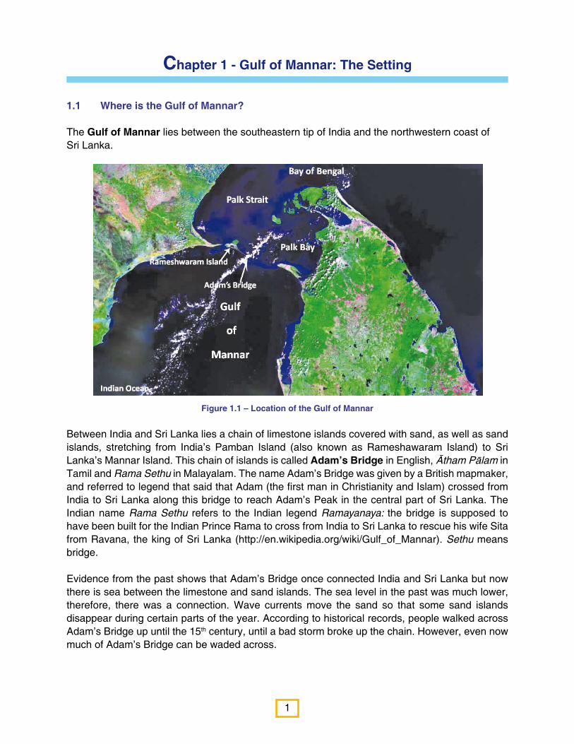
The Gulf of Mannar lies between the southeastern tip of India and the northwestern coast of Sri Lanka.
Between India and Sri Lanka lies a chain of limestone islands covered with sand, as well as sand islands, stretching from India’s Pamban Island (also known as Rameshawaram Island) to Sri Lanka’s Mannar Island. This chain of islands is called Adam’s Bridge in English, Ātham Pālam in Tamil and Rama Sethu in Malayalam. The name Adam’s Bridge was given by a British mapmaker, and referred to legend that said that Adam (the first man in Christianity and Islam) crossed from India to Sri Lanka along this bridge to reach Adam’s Peak in the central part of Sri Lanka. The Indian name Rama Sethu refers to the Indian legend Ramayanaya: the bridge is supposed to have been built for the Indian Prince Rama to cross from India to Sri Lanka to rescue his wife Sita from Ravana, the king of Sri Lanka (http://en.wikipedia.org/wiki/Gulf_of_Mannar). Sethu means bridge.
Evidence from the past shows that Adam’s Bridge once connected India and Sri Lanka but now there is sea between the limestone and sand islands. The sea level in the past was much lower, therefore, there was a connection. Wave currents move the sand so that some sand islands disappear during certain parts of the year. According to historical records, people walked across Adam’s Bridge up until the 15th century, until a bad storm broke up the chain. However, even now much of Adam’s Bridge can be waded across.
Figure 1.1 – Location of the Gulf of Mannar
2
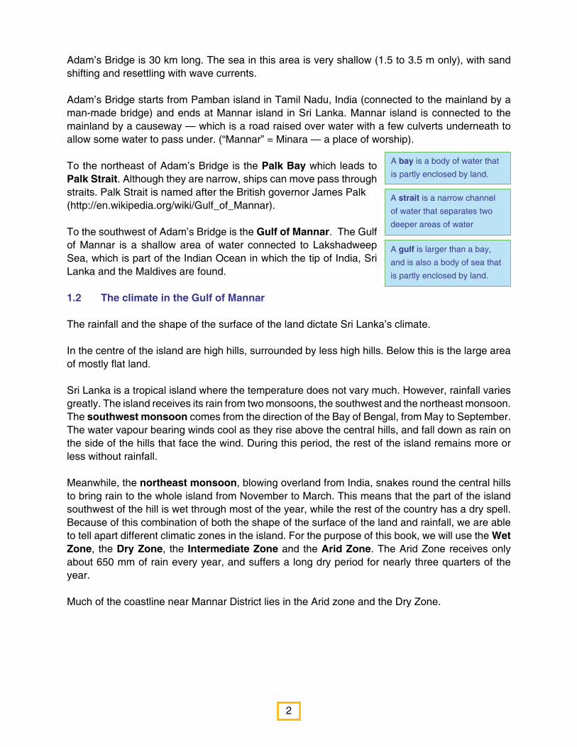
Adam’s Bridge is 30 km long. The sea in this area is very shallow (1.5 to 3.5 m only), with sand shifting and resettling with wave currents. Adam’s Bridge starts from Pamban island in Tamil Nadu, India (connected to the mainland by a man-made bridge) and ends at Mannar island in Sri Lanka. Mannar island is connected to the mainland by a causeway — which is a road raised over water with a few culverts underneath to allow some water to pass under. (“Mannar” = Minara — a place of worship). To the northeast of Adam’s Bridge is the Palk Bay which leads to Palk Strait. Although they are narrow, ships can move pass through straits. Palk Strait is named after the British governor James Palk(http://en.wikipedia.org/wiki/Gulf_of_Mannar).
To the southwest of Adam’s Bridge is the Gulf of Mannar. The Gulf of Mannar is a shallow area of water connected to Lakshadweep Sea, which is part of the Indian Ocean in which the tip of India, Sri Lanka and the Maldives are found.
1.2 The climate in the Gulf of Mannar
The rainfall and the shape of the surface of the land dictate Sri Lanka’s climate.
In the centre of the island are high hills, surrounded by less high hills. Below this is the large area of mostly flat land.
Sri Lanka is a tropical island where the temperature does not vary much. However, rainfall varies greatly. The island receives its rain from two monsoons, the southwest and the northeast monsoon. The southwest monsoon comes from the direction of the Bay of Bengal, from May to September. The water vapour bearing winds cool as they rise above the central hills, and fall down as rain on the side of the hills that face the wind. During this period, the rest of the island remains more or less without rainfall.
Meanwhile, the northeast monsoon, blowing overland from India, snakes round the central hills to bring rain to the whole island from November to March. This means that the part of the island southwest of the hill is wet through most of the year, while the rest of the country has a dry spell. Because of this combination of both the shape of the surface of the land and rainfall, we are able to tell apart different climatic zones in the island. For the purpose of this book, we will use the Wet Zone, the Dry Zone, the Intermediate Zone and the Arid Zone. The Arid Zone receives only about 650 mm of rain every year, and suffers a long dry period for nearly three quarters of the year.
Much of the coastline near Mannar District lies in the Arid zone and the Dry Zone.
A bay is a body of water that
is partly enclosed by land.
A strait is a narrow channel
of water that separates two
deeper areas of water
A gulf is larger than a bay,
and is also a body of sea that
is partly enclosed by land.

3
Figure 1.2 – The climatic zones of Sri Lanka
Climatic Zone Average Rainfall Remarks
Wet Zone 2,000 mm-5, 000 mm The up country wet zone generally receives rain throughout the year. The low country Wet Zone is likely to have about 5-6 months without rain.
Intermediate Zone
1,100 mm-2,000 mm The up country Intermediate Zone receives better •rainfall than the rest of the Intermediate Zone.Some parts of the mid country Intermediate Zone •may have about 6 months without rain. The low country Intermediate Zone may have •about 6 months without rain.
Dry Zone 700 mm-1,000 mm The Dry Zone receives rain only for about 3-4 months, mainly from the northeast monsoon. The rest of the year is dry.
Arid Zone About 650 mm The Arid Zone receives limited rain only for about three months. The lowest rainfall is in Hambantota. The rainfall in Mannar, Jaffna and parts of Kilinochchi district is also low (in the region of about 700 mm).
Adapted from Agro-ecological Map, Panabokke and Kannangara (1996)
Map Prepared by: International Union forconservation of Nature, Sri Lanka Country Office
Funded by: FAO under BOBLME ProjectComponet 2.4 Collaborative Critical HabitatManagement: Gulf of Mannar
The Climatic Zones of Sri Lanka
Arid Zone
Dry Zone
Intermediate Zone
Wet Zone
Arid Zone
N
4
Tides are the rise and fall of sea
levels caused by the combined
effects of the gravity exerted by the
Moon and the Sun as well as the
rotation of the Earth. Many coastal
areas go through a high tide (when
the sea level is high) and low tide
(when the sea level is low) once a
day, usually with a time difference
of 12 hours. Areas close together
— for example Colombo and
Negombo, go through high and low
tides around the same time.
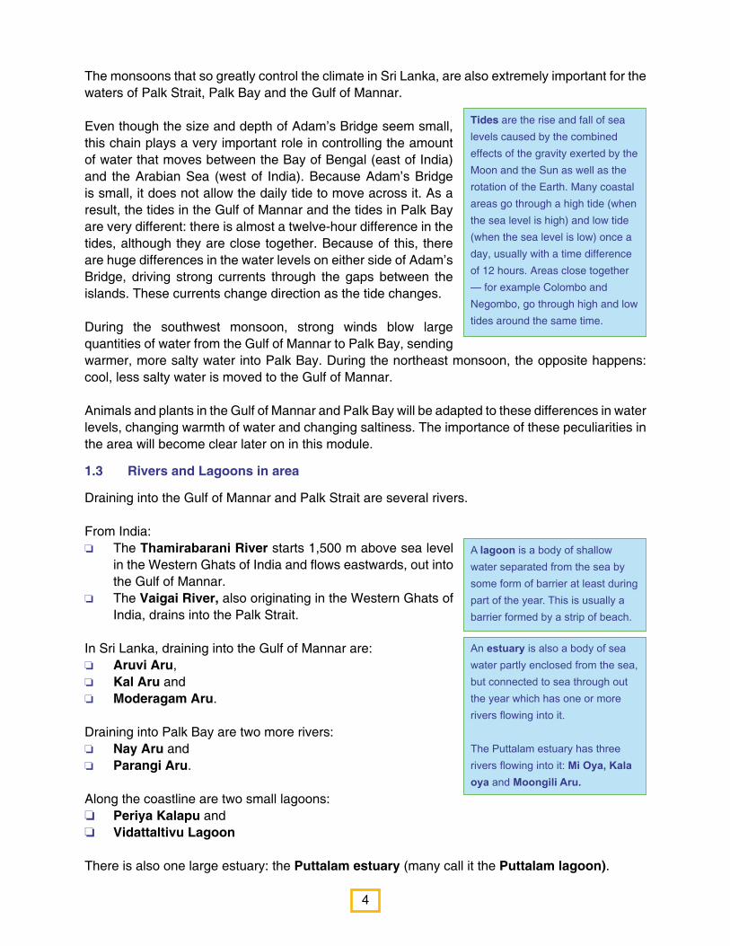
A lagoon is a body of shallow water separated from the sea by some form of barrier at least during part of the year. This is usually a barrier formed by a strip of beach.
An estuary is also a body of sea water partly enclosed from the sea, but connected to sea through out the year which has one or more rivers flowing into it.
The Puttalam estuary has three rivers flowing into it: Mi Oya, Kala oya and Moongili Aru.
The monsoons that so greatly control the climate in Sri Lanka, are also extremely important for the waters of Palk Strait, Palk Bay and the Gulf of Mannar.
Even though the size and depth of Adam’s Bridge seem small, this chain plays a very important role in controlling the amount of water that moves between the Bay of Bengal (east of India) and the Arabian Sea (west of India). Because Adam’s Bridge is small, it does not allow the daily tide to move across it. As a result, the tides in the Gulf of Mannar and the tides in Palk Bay are very different: there is almost a twelve-hour difference in the tides, although they are close together. Because of this, there are huge differences in the water levels on either side of Adam’s Bridge, driving strong currents through the gaps between the islands. These currents change direction as the tide changes.
During the southwest monsoon, strong winds blow large quantities of water from the Gulf of Mannar to Palk Bay, sending warmer, more salty water into Palk Bay. During the northeast monsoon, the opposite happens: cool, less salty water is moved to the Gulf of Mannar.
Animals and plants in the Gulf of Mannar and Palk Bay will be adapted to these differences in water levels, changing warmth of water and changing saltiness. The importance of these peculiarities in the area will become clear later on in this module.
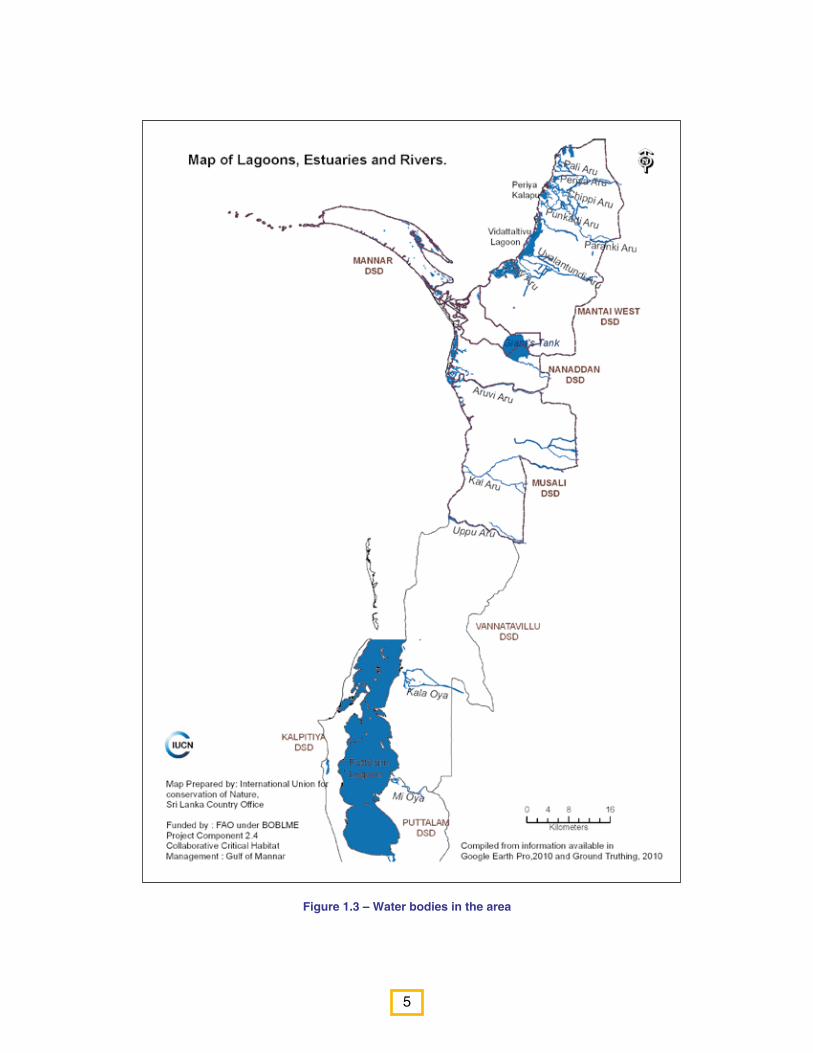
1.3 Rivers and Lagoons in area
Draining into the Gulf of Mannar and Palk Strait are several rivers.
From India:o The Thamirabarani River starts 1,500 m above sea level
in the Western Ghats of India and flows eastwards, out into the Gulf of Mannar.
o The Vaigai River, also originating in the Western Ghats of India, drains into the Palk Strait.
In Sri Lanka, draining into the Gulf of Mannar are: o Aruvi Aru,o Kal Aru and o Moderagam Aru.
Draining into Palk Bay are two more rivers: o Nay Aru and o Parangi Aru.
Along the coastline are two small lagoons: o Periya Kalapu and o Vidattaltivu Lagoon
There is also one large estuary: the Puttalam estuary (many call it the Puttalam lagoon).
5
Figure 1.3 – Water bodies in the area

6
1.4 The Sri Lankan coastline in the region of the Gulf of Mannar
Several divisional secretariat divisions of both Districts of Puttalam and Mannar line the coastline along the Gulf of Mannar and part of Palk Strait.
These are
o Kalpitiya and o Vanathavillu in the Puttalam District, o Mannar Town,o Manthai West, o Nananddan, and o Musali in the Mannar District.
o Below the national level of administration are provinces. Below the provincial layer of administration are districts.
o Divisional secretariat divisions are subdivisions of a district.
Figure 1.4 – Administrative divisions along the Sri Lankan coastline in the region of the Gulf of Mannar and Palk Strait
1.5 The people of the area
According to latest statistics, there are about 412,000 people living in the divisional secretariat divisions shown in Fig. 4. The highest number of persons per square kilometre (population density) is seen in Kalpitiya (524 persons per km2) and the next highest density is in Mannar, with 238 persons per km2. Mantai West has only 12 persons per km2.
7
Figure 1.5 - People of the area
Figure 1.6 – Coconut plantation(Sampath Goonatilake © IUCN)
Figure 1.7 – Fisheries(Kumudini Ekaratne © IUCN)
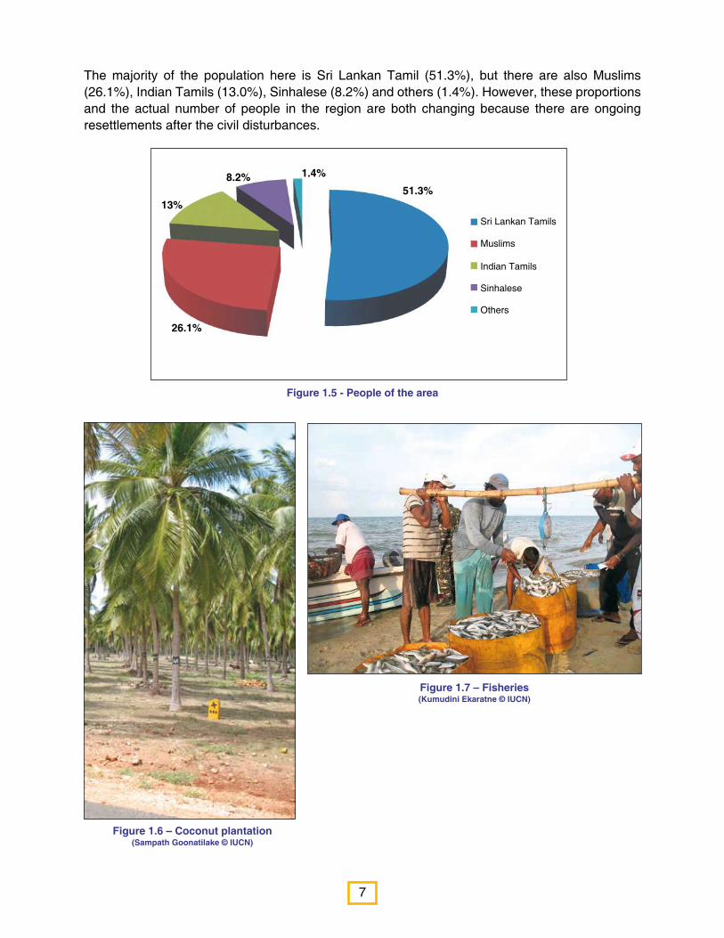
The majority of the population here is Sri Lankan Tamil (51.3%), but there are also Muslims (26.1%), Indian Tamils (13.0%), Sinhalese (8.2%) and others (1.4%). However, these proportions and the actual number of people in the region are both changing because there are ongoing resettlements after the civil disturbances.
51.3%
1.4%8.2%
13%
26.1%
Sri Lankan Tamils
Muslims
Indian Tamils
Sinhalese
Others

8
Summary of Chapter 1
o The Gulf of Mannar lies between the southeastern tip of India and the northwestern coast of Sri Lanka.
o Between India and Sri Lanka lies a chain of limestone islands covered with sand, as well as sand islands, called Adam’s Bridge.
o To the northeast of Adam’s Bridge is the Palk Bay, which leads to Palk Strait.
o To the southwest of Adam’s Bridge is the Gulf of Mannar.
o The coastal region of the Mannar district and Palk Strait lies in the Dry Zone of Sri Lanka, and part of it, in the Arid Zone.
o Adam’s Bridge controls the amount of water exchanged between the Gulf of Mannar and Palk Strait.
o The tides in the Gulf of Mannar and the tides in Palk Bay are very different: there is almost a twelve-hour difference in the tides, although they are close together. As a result, there are huge differences in water speeds in both areas.
o During the southwest monsoon, strong winds blow large quantities of water from the Gulf of Mannar to Palk Bay, sending warmer, more salty water into Palk Bay. During the northeast monsoon, the opposite happens: cool, less salty water is moved to the Gulf of Mannar.
o Draining into the Palk Strait and Gulf of Mannar are several rivers: the Thamirabarani and Vaigai Rivers from India; and Aruvi Aru, Kal Aru, Moderagam Aru, Nay Aru and Prangi Aru.
o Along the Sri Lanka coast lining the region of the Gulf of Mannar, are Periya Kalapu and Vidattalitivu Lagoons and the Puttalam estuary. Three more rivers — Mi oya, Kala oya and Moongili Aru — drain into the Puttalam estuary.
o Along the coastline are two divisional secretariat divisions in Puttalam District: Kalpitiya and Vanathavillu; and four in the Mannar District: Mannar Town, Mantai West, Nanaddan and Musali.
o There are 412,040 people in the area, with the highest population density in Kalpitiya (524 persons per km2), the next highest in Mannar, with 238 persons per km2) and the lowest density is in Mantai West with only 12 persons per km2.
o The majority of the population is Sri Lankan Tamil (51.3%), but there are also Muslims (26.1%), Indian Tamils (13.0%), Sinhalese (8.2%) and others (1.4%).
o Most of the people in Mannar are farmers. There are16,331 farmers in Mannar and nearly 7,500 fishermen.
1.6 What do the people of Mannar do?
o Most of the people in Mannar are farmers. There are 16,331 farmers in the Mannar district (Statistical Hand book Mannar District, 2009). Paddy, highland crops and plantation crops such as coconut, cashew and palmyrah are the main crops cultivated in Mannar.
o There are 7,547 active fishermen in Mannar.
o Salt production (Olaithoduval and Vankalai) and goat rearing (Tharapuram) are also common.
9
Chapter 2 - The Natural Wealth of the Area
The Gulf of Mannar region is rich with animals, plants and habitats. Studies on the plants and animals of the area have been carried out separately — both in India and Sri Lanka.
2. 1 Habitats and protected areas:
2.1.1 Protected areas:Studies from India show that the Gulf of Mannar has more than 3,000 different kinds of animals and plants and many different kinds of habitats).
Because of this, the Indian Government declared the area as a protected area.
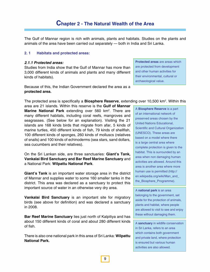
The protected area is specifically a Biosphere Reserve, extending over 10,500 km2. Within this area are 21 islands. Within this reserve is the Gulf of Mannar Marine National Park extending over 560 km2. There are many different habitats, including coral reefs, mangroves and seagrasses. (See below for an explanation). Visiting the 21 islands are 168 kinds birds that migrate from afar, 5 kinds of marine turtles, 450 different kinds of fish, 79 kinds of shellfish, 100 different kinds of sponges, 260 kinds of molluscs (relatives of snails) and 100 kinds of echinoderms (sea stars, sand dollars, sea cucumbers and their relatives).
On the Sri Lankan side, are three sanctuaries: Giant’s Tank, Vankalai Bird Sanctuary and Bar Reef Marine Sanctuary and a National Park: Wilpattu National Park.
Giant’s Tank is an important water storage area in the district of Mannar and supplies water to some 160 smaller tanks in the district. This area was declared as a sanctuary to protect this important source of water in an otherwise very dry area.
Vankalai Bird Sanctuary is an important site for migratory birds (see above for definition) and was declared a sanctuary in 2008.
Bar Reef Marine Sanctuary lies just north of Kalpitiya and has about 150 different kinds of coral and about 280 different kinds of fish.
There is also one national park in this area of Sri Lanka: Wilpattu National Park.
Protected areas are areas which
are protected from development
and other human activities for
their environmental, cultural or
archaeological value.
A national park is an area
belonging to the government, set
aside for the protection of animals,
plants and habitat, where people
are allowed to visit to see and enjoy
these without damaging them.
A sanctuary in wildlife conservation
in Sri Lanka, refers to an area
which contains both government
and private land, where protection
is ensured but various human
activities are also allowed.
A Biosphere Reserve is a part
of an international network of
preserved areas chosen by the
United Nations Educational,
Scientific and Cultural Organization
(UNESCO). These areas are
based on a model where there
is a large central area where
complete protection is given to the
habitat. This is surrounded by an
area when non damaging human
activities are allowed. Around this
area is another area where more
human use is permitted (http://
en.wikipedia.org/wiki/Man_and_
the_Biosphere_Programme).
10
Figure 2.1 – Protected areas in the Gulf of Mannar region
Wilpattu has nearly 60 villus (see below for description) and is one of the largest and oldest national parks in Sri Lanka. Some 280 different kinds of vertebrates are found in this Park, including elephants and leopards, and some 600 different kinds of flowering plants.
There are two forest reserves, governed by the Forest Department, called Neenthavil Forest Reserve and Mavillu Forest Reserve.
2.1.2 HabitatsStudies from Sri Lanka show that in this area there are
Forests,1. Inland wetland habitats,2. Coastal habitats and 3. Agricultural land.4.
Map Prepared: International Union forConservation of Nature, Sri Lanka Country OfficeFunded by: FAO under BOBLMe Project Component 2.4Collaborative Critical Habitat Management: Gulf of Mannar
Complied from information abailable inGoogle Earth Pro, 2010

11
Most plants and animal names are quite familiar. We know of elephants, leopards and mangos. But as we know,
there are different kinds of trees, coconut and palmyrah, for example, and each has their own common name. But
these common names are different in different languages and in different parts of the world. For example, here in
Sri Lanka, we call Margosa Kohomba in Sinhalese in the southern part of the country, and Arulundi in Tamil in the
northern part of the country. In India, these trees are called Neem. If you didn’t know this, you would probably think
that these were four different kinds of trees.
To avoid this confusion, scientists have special names for plants and animals. Each is given two names, much as
you have a first name and a last name. These scientific names are in Latin, so unless you know Latin, it is very hard
to make sense of them. However, if you want to look up more information about a particular mammal from another
book or the Internet, you must use its scientific name, because this is the same anywhere in the world.
Thus, Margosa is known scientifically as Azadirachta indica. When these scientific names are printed, they are
always printed in italics because they are Latin, not English. So you would print the name as Margosa (Azadirachta
indica), but when you write this name, you would underline the scientific name thus: Margosa (Azadirachta indica).
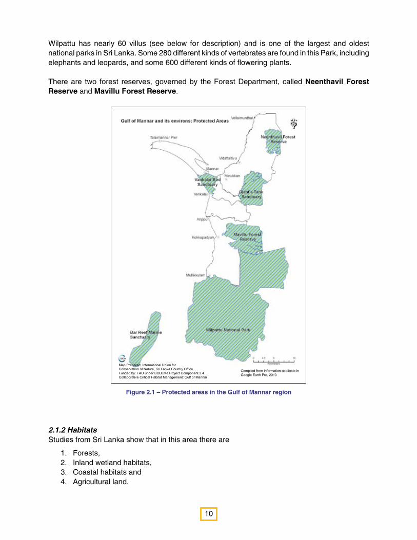
2.1.2.1 Forests In this region, there are two kinds of forests: Tropical dry-mixed evergreen forests and Tropical thorn forests (scrublands).
Tropical dry-mixed evergreen forests — also called Monsoon forests — are found in tropical areas that have a long dry season followed by a season of heavy rain. These seasons have a huge impact on these forests, whose plants and animals are adapted to deal with long periods without water. For example, many trees shed their leaves during the dry season.
Tropical dry-mixed evergreen forests can be seen in the Musali area.
Vegetation in tropical dry-mixed evergreen forests include o Palai (Sinhala: Palu; Scientific name: Manilkara hexandra), o Muthirai (Sinhala: Burutha; Scientific name: Chloroxylon swietenia), o Veerai/Veeraimaram (Sinhala: Weera; Scientific name: Drypetes sepiaria), o Tampanai (Sinhala: Tammanna; Scientific name: Mischodon zeylanicus),
o Chiru piyari (Sinhala: Pannakka; Scientific name: Pleurostylia opposita), o Parutti (Sinhala: Kapukinissa; Scientific name: Hibiscus eriocarpus) and
o Karanai (Sinhala: Tarana; Scientific name: Tarenna asiatica).
Wood is taken from tropical dry-mixed evergreen forests for use as fuelwood and for many other household purposes.
In Tropical thorn forests, the plants are generally adapted to survive very harsh conditions related to water. Some have small leaves (to avoid water loss through transpiration), others have thorns instead of leaves and yet other trees have water stored in their stems.

12
Figure 2.2 – Tropical dry-mixed evergreen forests in Musali DS (Sampath Goonatilake © IUCN)
When Tropical dry-mixed evergreen forests are destroyed, often, tropical thorn forests (scrublands) grow in their place. Tropical thorn forests also grow in arid areas where the dry season is very long. Plants in thorn forests have to conserve water, so they have small leaves or thorns, to reduce water loss, or store water in fleshy leaves and stems. During the dry season, leaves fall off.
Tropical thorn forests can be seen in Manthai west, Musali and Mannar Island.
Vegetation in tropical scrublands includes o Inchu (Sinhala: Indi; Scientific name: Phoenix pusilla); o Uvay/Vijay (Sinhala: Maliththan; Scientific name: Salvadora persica); o Udai/Odai (English: Umbrella Thorn; Scientific name: Acacia planifrons); o Kaludai (English: Cockspur Thorn; Scientific name: Acacia eburnea); o Kalli (English: Milk Hedge; Sinhala: Nawa Handi; Scientific name: Euphorbia tirucalli) and o Arugani (Sinhala: Hiressa; Scientific name: Cissus quadrangularis).
Wood is taken from tropical thorn forests for use as fuelwood and for many other household purposes, such as medicines.
In tropical thorn forests, the plants are generally adapted to survive very harsh conditions related to water. Some have small leaves (to avoid water loss through transpiration), others have thorns instead of leaves and yet others tree have water stored in their stems.
13
Figure 2.3 – Tropical thorn forests in Wilpattu National Park (Sampath Goonatilake © IUCN)
Figure 2.4 – Kala Oya Causeway (Sampath Goonatilake © IUCN)
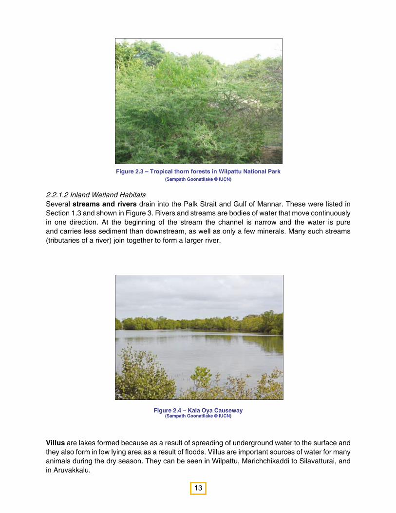
2.2.1.2 Inland Wetland HabitatsSeveral streams and rivers drain into the Palk Strait and Gulf of Mannar. These were listed in Section 1.3 and shown in Figure 3. Rivers and streams are bodies of water that move continuously in one direction. At the beginning of the stream the channel is narrow and the water is pure and carries less sediment than downstream, as well as only a few minerals. Many such streams (tributaries of a river) join together to form a larger river.
Villus are lakes formed because as a result of spreading of underground water to the surface and they also form in low lying area as a result of floods. Villus are important sources of water for many animals during the dry season. They can be seen in Wilpattu, Marichchikaddi to Silavatturai, and in Aruvakkalu.

14
Figure 2.5 – Giant’s Tank during the dry season (Sampath Goonatilake © IUCN)
Reservoirs or Tanks were made by Sri Lanka’s ancient kings to help store water for agriculture and other human use. Many of these — such as Giant’s Tank — are found in the area.
2.2.1.3 Coastal and marine habitatsIn this region there are also many coastal and marine habitats. They are
Mangroves, 1. Salt marshes, 2. Sand dunes and beaches (including seashore vegetation),3. Mud flats, 4. Sea grass meadows, and5. Coral Reefs. 6.
Mangroves
A mangrove can either mean a woody plant or a group of plants which live between the sea and the land in areas which are flooded by tides for part of the time. Mangroves are unique because they grow where no other trees can survive — between the ocean and land. In this area, the tide rises and falls daily, and the saltiness of the water changes with this rise and fall of the tide. The soil is soggy with water and therefore, has little oxygen. The soil also moves with the tide. Mangrove plants and animals are especially adapted to this lack of oxygen, movement water and soil and changing saltiness. Many mangroves have roots that stretch out from the main trunk (stilt roots) to better attach them to the shifting soil. They also have roots that poke out into the air from the soil, seeking oxygen. These roots are called breathing roots.
Mangroves can be seen in Manthai west.
Many different kinds of mangroves can be seen in the region. Among the most common are
o The Grey Mangrove (Tamil: Kannamaram; Scientific name: Avicennia marina) without stilt roots but with pencil-shaped breathing roots;
o Mangrove (Sinhala: Kadol: Tamil: Kandal; Scientific name: Rhizophora mucronata) with many branching stilt roots and
15
Figure 2.6 – Mangrove habitat at Palakamunai(Sampath Goonatilake © IUCN)
o Mangrove Apple (Sinhala: Kirala; Tamil: Kinnai; Scientific name: Sonneratia alba) with peg-like breathing roots.
Mangroves provide humans with many goods such as food, firewood, fuelwood, timber and medicine, and serve to prevent erosion, filter soil from pollutants and serve as a physical barrier to protect the shoreline.
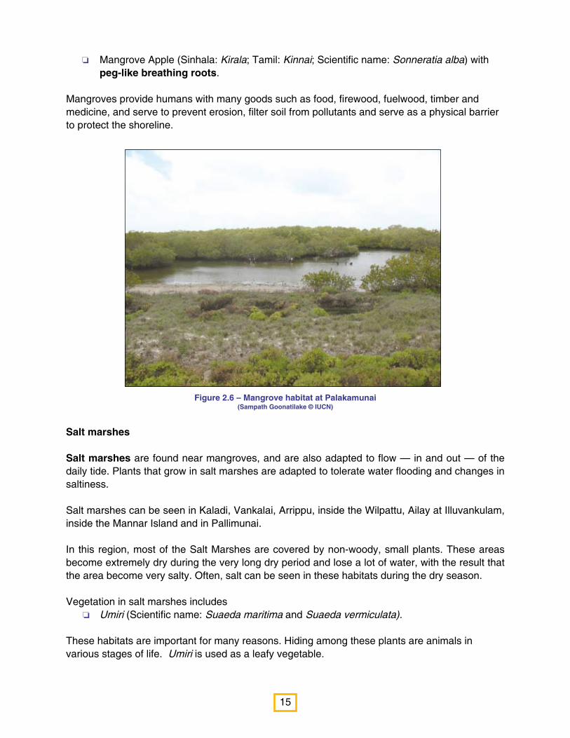
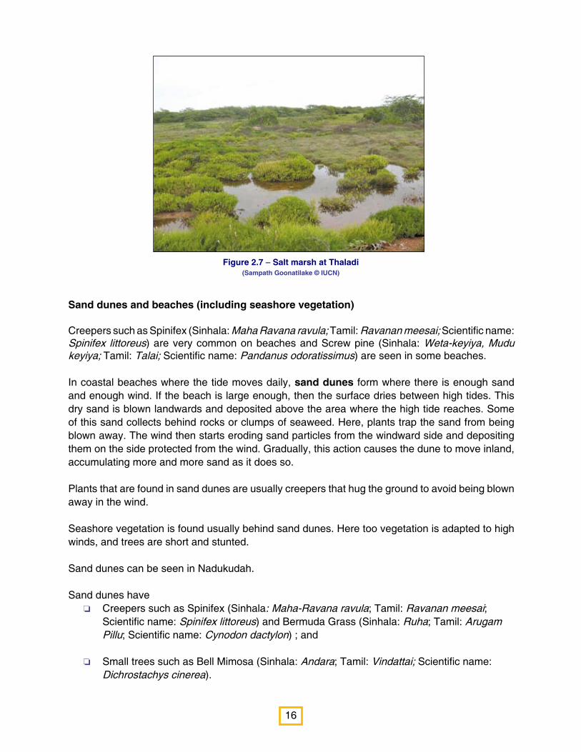
Salt marshes
Salt marshes are found near mangroves, and are also adapted to flow — in and out — of the daily tide. Plants that grow in salt marshes are adapted to tolerate water flooding and changes in saltiness.
Salt marshes can be seen in Kaladi, Vankalai, Arrippu, inside the Wilpattu, Ailay at Illuvankulam, inside the Mannar Island and in Pallimunai.
In this region, most of the Salt Marshes are covered by non-woody, small plants. These areas become extremely dry during the very long dry period and lose a lot of water, with the result that the area become very salty. Often, salt can be seen in these habitats during the dry season.
Vegetation in salt marshes includes o Umiri (Scientific name: Suaeda maritima and Suaeda vermiculata).
These habitats are important for many reasons. Hiding among these plants are animals in various stages of life. Umiri is used as a leafy vegetable.
16
Figure 2.7 – Salt marsh at Thaladi (Sampath Goonatilake © IUCN)
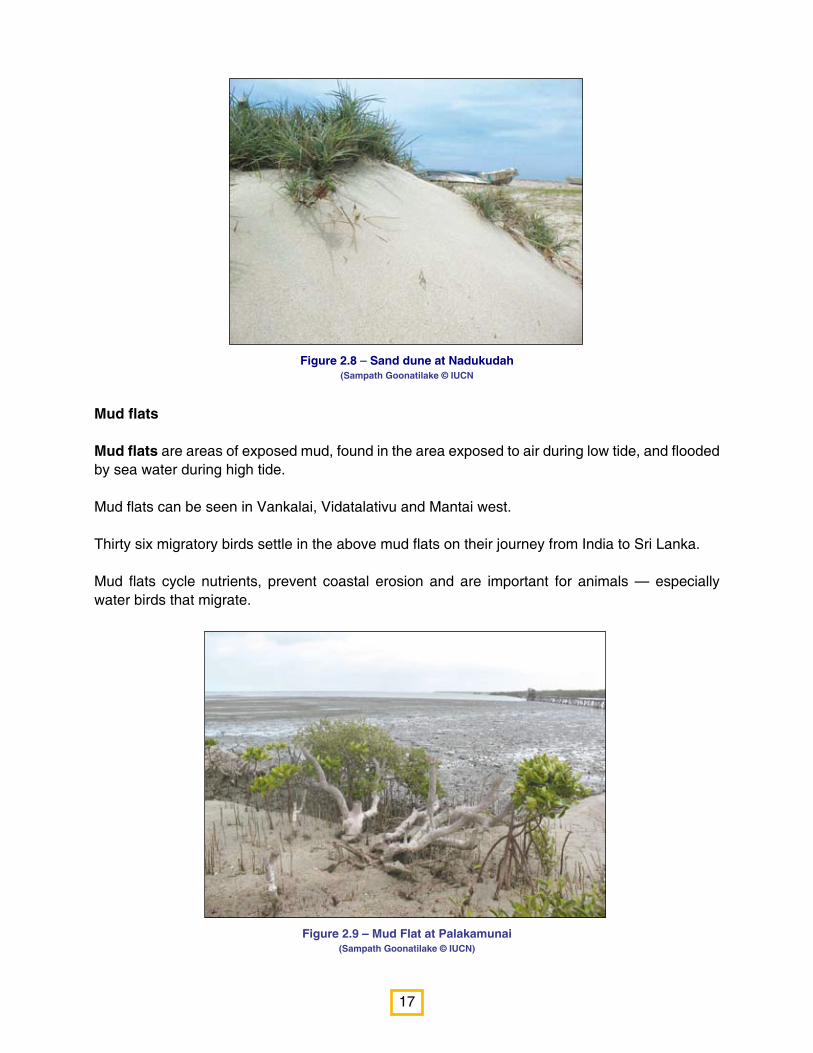
Sand dunes and beaches (including seashore vegetation)
Creepers such as Spinifex (Sinhala: Maha Ravana ravula; Tamil: Ravanan meesai; Scientific name: Spinifex littoreus) are very common on beaches and Screw pine (Sinhala: Weta-keyiya, Mudu keyiya; Tamil: Talai; Scientific name: Pandanus odoratissimus) are seen in some beaches.
In coastal beaches where the tide moves daily, sand dunes form where there is enough sand and enough wind. If the beach is large enough, then the surface dries between high tides. This dry sand is blown landwards and deposited above the area where the high tide reaches. Some of this sand collects behind rocks or clumps of seaweed. Here, plants trap the sand from being blown away. The wind then starts eroding sand particles from the windward side and depositing them on the side protected from the wind. Gradually, this action causes the dune to move inland, accumulating more and more sand as it does so.
Plants that are found in sand dunes are usually creepers that hug the ground to avoid being blown away in the wind.
Seashore vegetation is found usually behind sand dunes. Here too vegetation is adapted to high winds, and trees are short and stunted.
Sand dunes can be seen in Nadukudah.
Sand dunes have o Creepers such as Spinifex (Sinhala: Maha-Ravana ravula; Tamil: Ravanan meesai;
Scientific name: Spinifex littoreus) and Bermuda Grass (Sinhala: Ruha; Tamil: Arugam Pillu; Scientific name: Cynodon dactylon) ; and
o Small trees such as Bell Mimosa (Sinhala: Andara; Tamil: Vindattai; Scientific name: Dichrostachys cinerea).
17
Figure 2.8 – Sand dune at Nadukudah (Sampath Goonatilake © IUCN
Figure 2.9 – Mud Flat at Palakamunai (Sampath Goonatilake © IUCN)
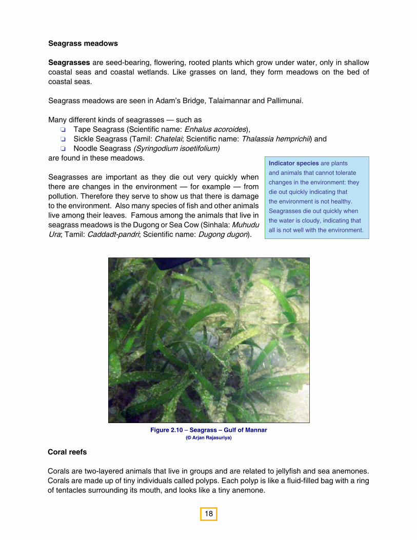
Mud flats
Mud flats are areas of exposed mud, found in the area exposed to air during low tide, and flooded by sea water during high tide.
Mud flats can be seen in Vankalai, Vidatalativu and Mantai west.
Thirty six migratory birds settle in the above mud flats on their journey from India to Sri Lanka.
Mud flats cycle nutrients, prevent coastal erosion and are important for animals — especially water birds that migrate.
18
Figure 2.10 – Seagrass – Gulf of Mannar (© Arjan Rajasuriya)
Indicator species are plants
and animals that cannot tolerate
changes in the environment: they
die out quickly indicating that
the environment is not healthy.
Seagrasses die out quickly when
the water is cloudy, indicating that
all is not well with the environment.
Seagrass meadows
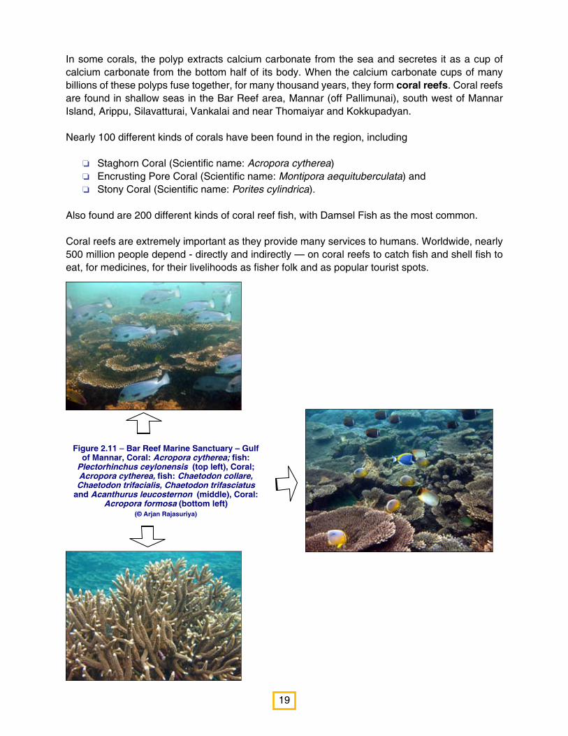
Seagrasses are seed-bearing, flowering, rooted plants which grow under water, only in shallow coastal seas and coastal wetlands. Like grasses on land, they form meadows on the bed of coastal seas.
Seagrass meadows are seen in Adam’s Bridge, Talaimannar and Pallimunai.
Many different kinds of seagrasses — such as o Tape Seagrass (Scientific name: Enhalus acoroides), o Sickle Seagrass (Tamil: Chatelai; Scientific name: Thalassia hemprichii) and o Noodle Seagrass (Syringodium isoetifolium)
are found in these meadows.
Seagrasses are important as they die out very quickly when there are changes in the environment — for example — from pollution. Therefore they serve to show us that there is damage to the environment. Also many species of fish and other animals live among their leaves. Famous among the animals that live in seagrass meadows is the Dugong or Sea Cow (Sinhala: Muhudu Ura; Tamil: Caddadt-pandri; Scientific name: Dugong dugon).
Coral reefs
Corals are two-layered animals that live in groups and are related to jellyfish and sea anemones. Corals are made up of tiny individuals called polyps. Each polyp is like a fluid-filled bag with a ring of tentacles surrounding its mouth, and looks like a tiny anemone.
19
Figure 2.11 – Bar Reef Marine Sanctuary – Gulf of Mannar, Coral: Acropora cytherea; fish:
Plectorhinchus ceylonensis (top left), Coral; Acropora cytherea, fish: Chaetodon collare, Chaetodon trifacialis, Chaetodon trifasciatus
and Acanthurus leucosternon (middle), Coral: Acropora formosa (bottom left)
(© Arjan Rajasuriya)
In some corals, the polyp extracts calcium carbonate from the sea and secretes it as a cup of calcium carbonate from the bottom half of its body. When the calcium carbonate cups of many billions of these polyps fuse together, for many thousand years, they form coral reefs. Coral reefs are found in shallow seas in the Bar Reef area, Mannar (off Pallimunai), south west of Mannar Island, Arippu, Silavatturai, Vankalai and near Thomaiyar and Kokkupadyan.
Nearly 100 different kinds of corals have been found in the region, including
o Staghorn Coral (Scientific name: Acropora cytherea)o Encrusting Pore Coral (Scientific name: Montipora aequituberculata) and o Stony Coral (Scientific name: Porites cylindrica).
Also found are 200 different kinds of coral reef fish, with Damsel Fish as the most common.
Coral reefs are extremely important as they provide many services to humans. Worldwide, nearly 500 million people depend - directly and indirectly — on coral reefs to catch fish and shell fish to eat, for medicines, for their livelihoods as fisher folk and as popular tourist spots.
20
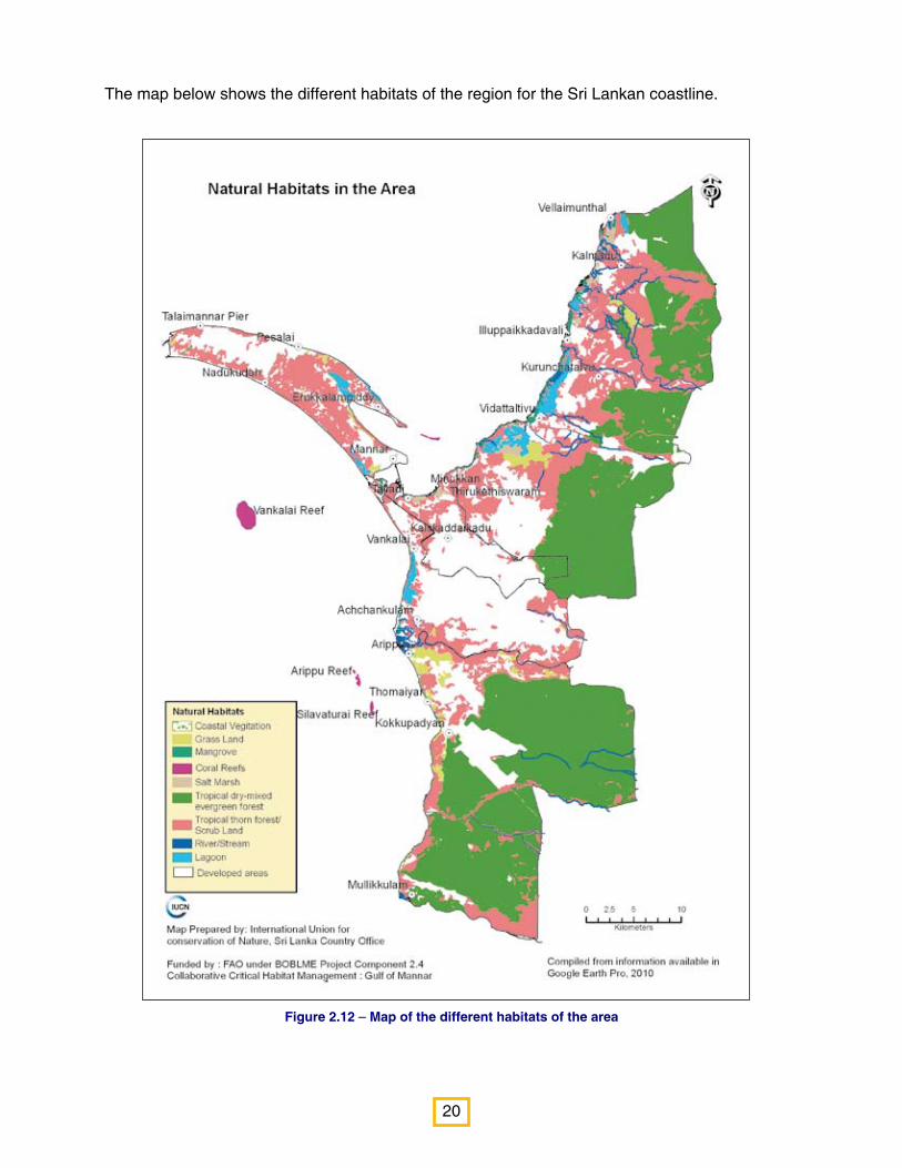
Figure 2.12 – Map of the different habitats of the area
The map below shows the different habitats of the region for the Sri Lankan coastline.
21
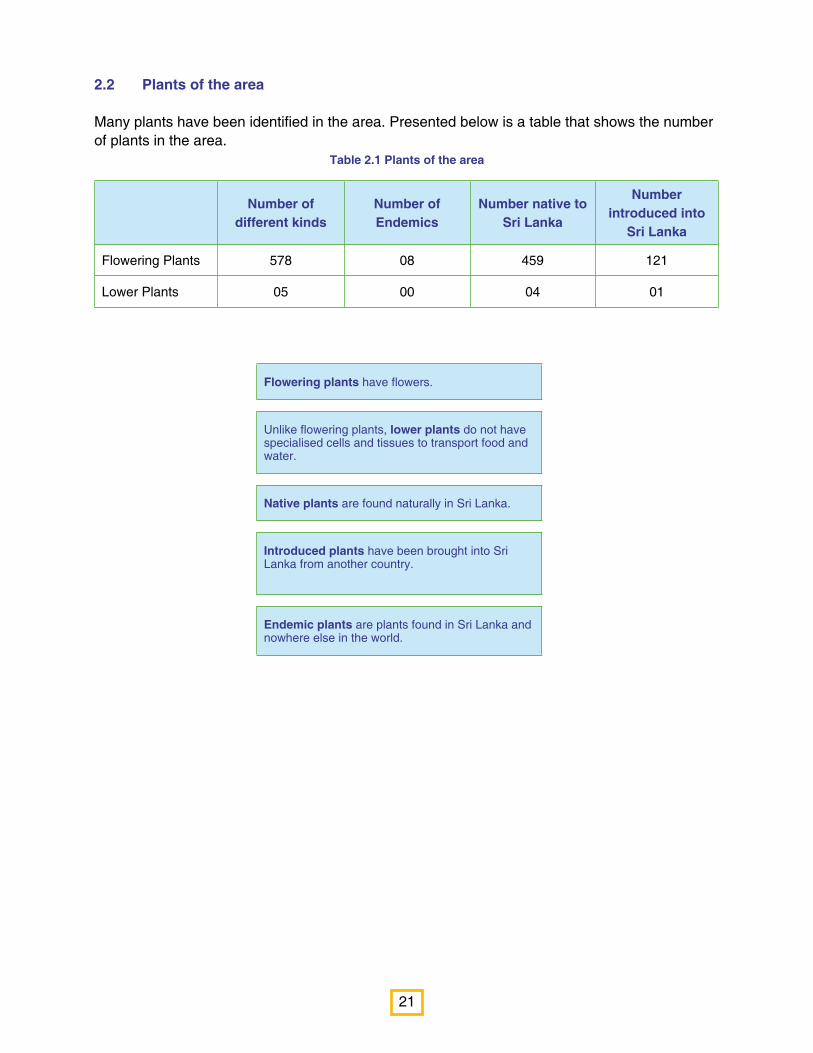
2.2 Plants of the area
Many plants have been identified in the area. Presented below is a table that shows the number of plants in the area.
Table 2.1 Plants of the area
Number of different kinds
Number of Endemics
Number native to Sri Lanka
Number introduced into
Sri Lanka
Flowering Plants 578 08 459 121
Lower Plants 05 00 04 01
Flowering plants have flowers.
Unlike flowering plants, lower plants do not have specialised cells and tissues to transport food and water.
Native plants are found naturally in Sri Lanka.
Introduced plants have been brought into Sri Lanka from another country.
Endemic plants are plants found in Sri Lanka and nowhere else in the world.

22
Figure 2.13 – Proportion of Introduced (20%) and native plants (80%) in the area
Figure 2.14 – Proportion of Endemic flowering plants (1.8%) in the area
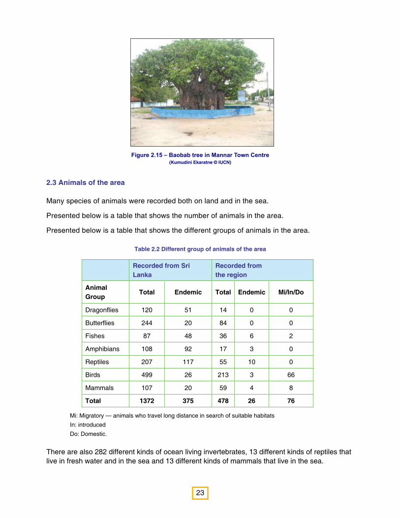
Special to the area are the Baobab Trees found in Mannar Town Division. There are around 40 of these Baobab
trees (Adansonia digitata). Native to the African continent, these trees were brought to the island by early Arabian
traders around 700 AD.
These trees store water in the enormous trunks (some as much as 19.5 m around the thickest part) as a means of
surviving the dry season. They shed their leaves easily to avoid water loss.
Among the endemic species found in this region are Kappilay (Sinhala: Pupula; Scientific name: Vernonia zeylanica), and Piyari (Sinhala: Neralu; Scientific name: Cassine glauca).
Other common species have been listed under the various habitats.
80%20%
Number native toSri Lanka
Numberintroduced intoSri Lanka
Number of different kinds of plants
Number of endemic plants
8
578
23
Figure 2.15 – Baobab tree in Mannar Town Centre (Kumudini Ekaratne © IUCN)
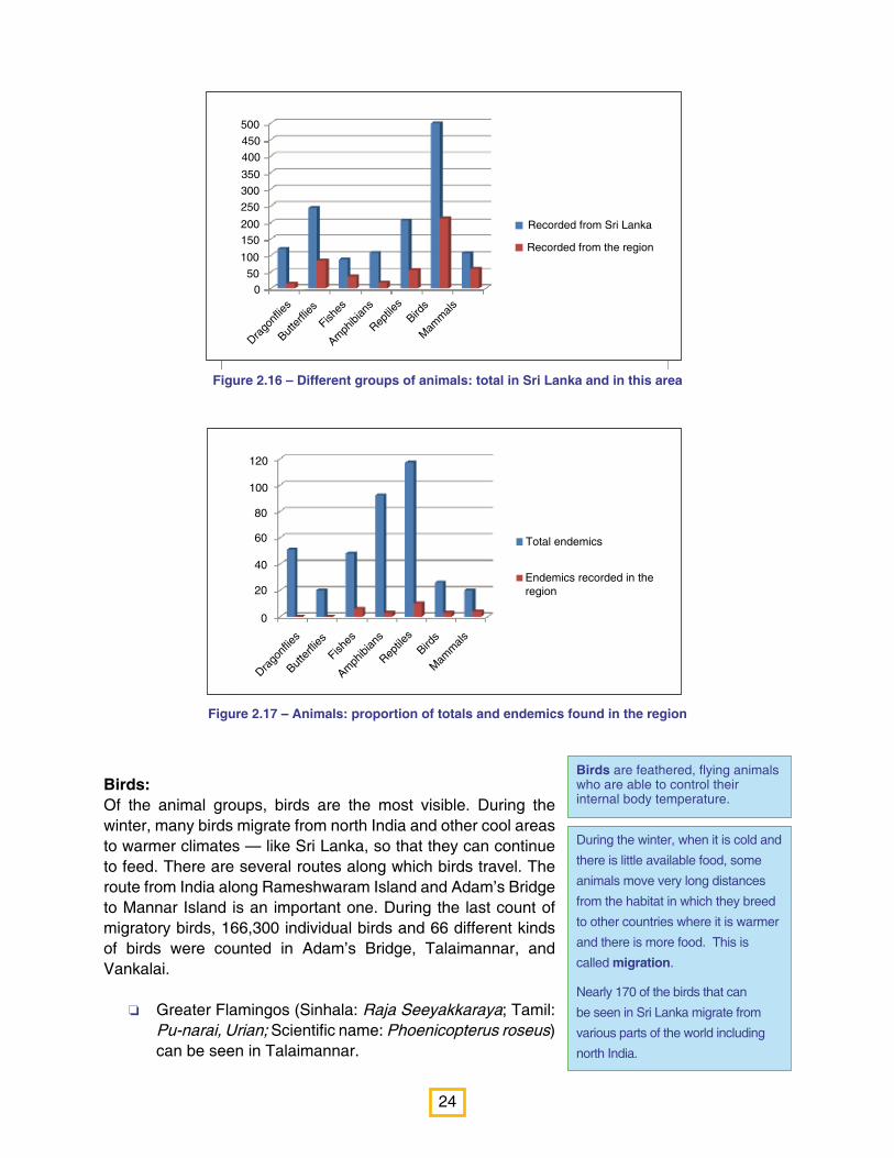
2.3 Animals of the area
Many species of animals were recorded both on land and in the sea.
Presented below is a table that shows the number of animals in the area.
Presented below is a table that shows the different groups of animals in the area.
Table 2.2 Different group of animals of the area
Recorded from Sri Lanka
Recorded from the region
Animal Group
Total Endemic Total Endemic Mi/In/Do
Dragonflies 120 51 14 0 0
Butterflies 244 20 84 0 0
Fishes 87 48 36 6 2
Amphibians 108 92 17 3 0
Reptiles 207 117 55 10 0
Birds 499 26 213 3 66
Mammals 107 20 59 4 8
Total 1372 375 478 26 76
Mi: Migratory — animals who travel long distance in search of suitable habitats
In: introduced
Do: Domestic.
There are also 282 different kinds of ocean living invertebrates, 13 different kinds of reptiles that live in fresh water and in the sea and 13 different kinds of mammals that live in the sea.
24
Figure 2.16 – Different groups of animals: total in Sri Lanka and in this area
Figure 2.17 – Animals: proportion of totals and endemics found in the region
During the winter, when it is cold and
there is little available food, some
animals move very long distances
from the habitat in which they breed
to other countries where it is warmer
and there is more food. This is
called migration.
Nearly 170 of the birds that can
be seen in Sri Lanka migrate from
various parts of the world including
north India.
Birds are feathered, flying animals who are able to control their internal body temperature.
Birds:Of the animal groups, birds are the most visible. During the winter, many birds migrate from north India and other cool areas to warmer climates — like Sri Lanka, so that they can continue to feed. There are several routes along which birds travel. The route from India along Rameshwaram Island and Adam’s Bridge to Mannar Island is an important one. During the last count of migratory birds, 166,300 individual birds and 66 different kinds of birds were counted in Adam’s Bridge, Talaimannar, and Vankalai.
o Greater Flamingos (Sinhala: Raja Seeyakkaraya; Tamil: Pu-narai, Urian; Scientific name: Phoenicopterus roseus) can be seen in Talaimannar.
Recorded from Sri Lanka
Recorded from the region
Drago
nflies
Butte
rflies
Fishes
Amph
ibian
s
Reptile
sBird
s
Mam
mals
500
450
400
350
300
250
200150
100
500
Drago
nflies
Butte
rflies
Fishes
Amph
ibian
s
Reptile
sBird
s
Mam
mals
Total endemics
Endemics recorded in theregion
120
100
80
60
40
20
0
25
Reptiles have scaly skins, and
generally lay eggs with protective
shells. They are dependent on the
environment to control their body
temperature.
Mammals feed their young with
milk produced from special glands.
Like birds, they are able to control
their internal body temperature.
Among the endemic birds found in the region are o Sri Lanka Junglefowl (Sinhala: Weli kukula; Tamil: Kattu-koli; Scientific name: Gallus
lafayetii) and o Sri Lanka Grey Hornbill (Sri Lanka: Alu Kandaththa; Tamil: Irattai-chondu- kuruvi:
Scientific name: Ocyceros gingalensis).
Mammals:Seventy two different kinds of mammals are found in the coast lining the region of the Gulf of Mannar and waters in the region.
Among the common mammals of the area are o Grey Langur (Sinhala: Eli-wandura; Tamil: Mundi
Kurangu; Scientific name: Semnopithecus priam);o Grey Mongoose (Sinhala: Alu Mugatiya; Tamil: Keeri;
Scientific name: Herpestes edwardsii).
Among the endemic mammals found in the area are o Sri Lanka Toque Monkey (Sinhala: Rilawa; Tamil: Kurangu; Scientific name: Macaca
sinica) and o Golden Dry Zone Palm Civet (Sinhala: Ran Hothambuva; Tamil: Maram Nai; Scientific
name: Paradoxurus stenocephalus).
Reptiles: Sixty nine different kinds of reptiles are found in the region and in the waters of the region.
Among the common reptiles are o Green Garden Lizard (Sinhala: Pala katussa; Tamil:
Pachchai Onnan; Scientific name: Calotes calotes); o Land Monitor (Sinhala: Thalagoya; Tamil: Udumbu;
Scientific name: Varanus bengalensis); ando Indian Python (Sinhala: Pimbura; Tamil: Periya pambu; Scientific name: Python molurus).
Among the endemic reptiles are o Common Lanka Skink (Sinhala: Sulaba lakhiraluva; Scientific name: Lankascincus
fallax); and o Striped flying snake (Sinhala: Dangara danda; Scientific name: Chrysopelea
taprobanica).
The coastline in this region is important for Hawksbill Turtles (Sinhala: Pothu kasbaeva; Tamil: Alunk amai; Scientific name: Eretmochelys imbricata) who come to lay their eggs in the sand.
26
Amphibians:There are few amphibians in this area, as it is very dry. Amphibians needs moisture to keep their skins wet.
Among the common amphibians in the area are o Ornate Narrow-mouthed Frog (Sinhala: Visituru
muwapatu madiya; Scientific name: Microhyla ornata) and
o Skipper Frog (Sinhala: Utpatana madiya; Scientific name: Euphlyctis cyanophlyctis).
Among the endemic amphibians are o Common Hour-glass Tree Frog (Sinhala: Sulaba pahimbu
gas madiya; Scientific name: Polypedates cruciger) and o Sri Lanka Wood Frog (Sinhala: Lanka bandi madiya; Scientific name: Hylarana gracilis).
Freshwater fish:There are thirty six different kinds of freshwater fish in this region. Among the most common are
o Tilapia (Scientific name: Oreochromis mossambicus) and
o Blue Eye (Sinhala: Handi titteya; Scientific name: Oyizias dancena).
Among the endemic fresh water fish are o Filamented Barb (Sinhala: Damkola pethiya; Scientific
name: Puntius sinhala) ando Walking Catfish (Sinhala: Magura; Scientific name:
Clarias brachysoma).
Marine fish:There are 122 different kinds of marine fish caught by fishermen. Eighty of these fish that are caught are important as food for people in the area and 42 are important for ornamental purposes.
Among the most commonly caught food fish are o White sardinella (Sinhala: Sudaya; Tamil: Thatta-kavalai, Choodai; Scientific name:
Sardinella albella) and o Indian Ilsha (Sinhala: As bokka; Tamil: Thattakuthuva; Scientific name: Ilisha melastoma).
Special to the area, are introduced domestic donkeys, now become wild, called Mannar Ponies (Sinhala:
Diweldiwa Poniya; Scientific name: Equus caballus). These were introduced by Arab traders in the past.
Adult amphibians are air-
breathing, insect-eating, animals
that live on land, while their young
(tadpoles) live in fresh water,
breathing oxygen dissolved in
water and feeding on plant matter.
Amphibian eggs do not have a
shell, therefore amphibians need
water or very damp conditions
for females to lay her eggs near
or in water. Frogs and toads are
amphibians.
Fish are animals who can live only
in water and are shaped to move
smoothly and fast through water.
They breathe oxygen dissolved in
water through breathing organs
called gills.
There are fish that live in
freshwater bodies such as tanks,
rivers and villus. These are called
freshwater fish.
27
Summary of Chapter 2
o The region is rich with animals, plants and habitats.
o There is a Biosphere reserve on the Indian side of the Gulf of Mannar called the Gulf of
Mannar Biosphere reserve. Within this is the Gulf of Mannar National Park.
o On the Sri Lanka side are two sanctuaries: Giant’s Tank and Vankalai Bird Sanctuary. There
are also two national parks: Wilpattu and Bar Reef Sanctuary.
o In Sri Lanka, there are Forests, Inland wetland habitats, Coastal habitats and Agricultural land.
o There are two different kinds of forests in the area: tropical dry-mixed evergreen forests and
tropical thorn forests.
o There are several kinds of Inland wetland habitats in the area: streams and rivers, villus and
reservoirs.
o In this region there are also many coastal and marine habitats. They are Mangroves, Salt
marshes, Sand dunes and beaches (including seashore vegetation), Mud flats, Sea grass
meadows and Coral Reefs.
o Five hundred and seventy eight different kinds of flowering plants of which eight are endemic
are found in the region.
o Four hundred and seventy eight different kinds of land living animals were found in the
region. Of these 26 were endemic to Sri Lanka. There are also 282 different kinds of marine
invertebrates in the area, 13 reptiles that live in fresh or sea water and 13 different kinds of
mammals that live in the sea.
o Baobab trees and Mannar Ponies are special to the area, having been introduced in the past
by Arab traders.
Invertebrates: Two hundred and eighty two invertebrates were observed in the Gulf of Mannar and Palk Bay.
Among the different kinds of invertebrates collected by fishermen to sell for export are
o Sea anemones — soft-bodied, colourful relatives of corals which are very popular for use in aquaria;
o Seashells, including Tiger Cowries (Scientific name: Cypraea tigris) and Common Spider Conch (Scientific name: Lambis lambis) all of which are popular as ornaments and
o Sea cucumbers (Sinhala: Muhudu kakiri; Scientific name: mainly different kinds of Holothuria) — soft-bodied animals with a leathery skin and long bag-like bodies, who are relatives of sea stars and sea urchins. These are slated, boiled, dried and packaged for export to China and other far eastern countries, where it is valued for food.

28
Figure 3.1 – Aruvakkalu fossil deposit (Sampath Goonatilake © IUCN)
Archaeology is the scientific
study of past cultures and the way
people lived, based on the things
they left behind.
Culture is the shared ways of
life learned by a group of people,
including their language, religion,
technology, and values.
A fossil is the prehistoric remains
of a plant or animal.
Fossils are usually preserved when
they are buried under many layers
of sand and mud. After many
years and under great pressure
the sand and mud become rock.
Minerals ooze the fossil replacing
the organic matter and creating a
duplicate stone.
Chapter 3 - The Archaeological and Cultural Significance of theGulf of Mannar Region
Because the Gulf of Mannar is so close to India and because Adam’s Bridge is so shallow, traders found it easy to come from India to Sri Lanka, across this shallow area. Elephants, pearls and shells were traded among many other things in the past.
This would also have been an easy point of invasion from India.
Fossils of animals — such as worms, corals, snails, fish, reptiles and marine mammals — have been found in this region. Fossil deposits have been found in
o Uchchamunai and Karaitivu Island in the Kalpitiya divisional secretariat division,
o Aruwakalu in the Vanathavillu divisional secretariat division, o Kal Aru river bed in the Musali divisional secretariat
division, o Mannar Island; and o Palugahaturai, and Kudiremalai in Wilpattu National Park.
29
Figure 3.2 – Prehistoric stone tools that were used for cutting and chopping, discovered from Aruwakkalu
in Vanathavillu Divisional Secretariat Division.(Sampath Goonatilake © IUCN
Prehistoric period: the period
during which stone tools were used
by humans;
Proto-historic period: the
period during which humans
domesticated animals and started
making and using pottery;
Historical period: the period
during which there are written
records.
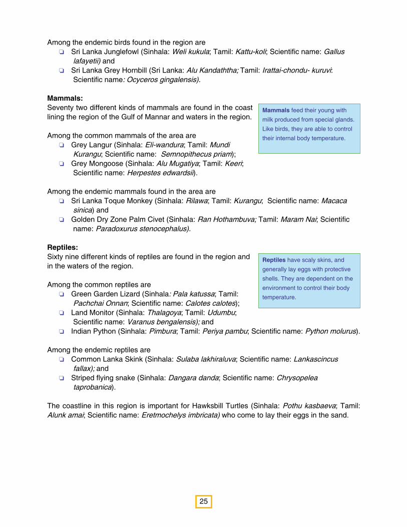
Many prehistoric human settlements have been found in this area, showing stone age tools in:
o Aruwakalu, Kudiremalai, Pomparippu and around several villu habitats in Wilpattu National park. These tools are believed to belong to people who first migrated across Adam’s Bridge when there was a land connection.
Many Proto-historic and Historical monuments can also be seen at Gangewadiya, the banks of Pomparippu Ara, Pomparippu, Palugahaturai and Pukkulam in the Vanatavillu divisional secretariat division,
o Silavaturai and Arippu (also known as Muthuarippu-thurai) in the Musali divisional secretariat division;
o Pasalai and Talaimannar in the Mannar town divisional secretariat division and
o Mantai fort in the Mantai West divisional secretariat division. There are several inscriptions referring to Kings who ruled during the Anuradhapura period in this site, showing the importance of this site for trade and culture of that time.
o Several Buddhist and Hindu monasteries which belong to Anuradhapura and later period are also found in the Kalpitiya, Vanathavillu, Musali, Mantai west divisional secretariat divisions.
o Arabian sailors came to the ancient Mantai port for trade and Baobab trees were brought to the island by them.
30
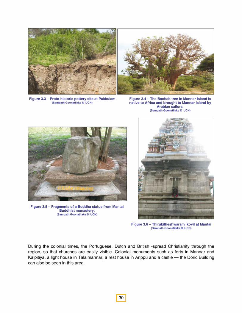
Figure 3.3 – Proto-historic pottery site at Pukkulam(Sampath Goonatilake © IUCN)
Figure 3.4 – The Baobab tree in Mannar Island is native to Africa and brought to Mannar Island by
Arabian sailors.(Sampath Goonatilake © IUCN)
Figure 3.5 – Fragments of a Buddha statue from Mantai Buddhist monastery.
(Sampath Goonatilake © IUCN)
Figure 3.6 – Thirukitheshwaram kovil at Mantai(Sampath Goonatilake © IUCN)
During the colonial times, the Portuguese, Dutch and British -spread Christianity through the region, so that churches are easily visible. Colonial monuments such as forts in Mannar and Kalpitiya, a light house in Talaimannar, a rest house in Arippu and a castle — the Doric Building can also be seen in this area.
31
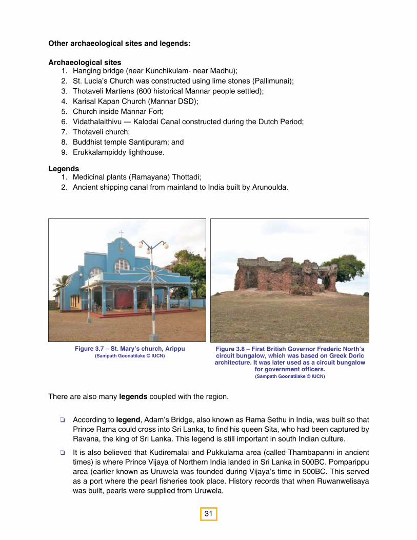
Figure 3.7 – St. Mary’s church, Arippu(Sampath Goonatilake © IUCN)
Figure 3.8 – First British Governor Frederic North’s circuit bungalow, which was based on Greek Doric architecture. It was later used as a circuit bungalow
for government officers.(Sampath Goonatilake © IUCN)
Other archaeological sites and legends:
Archaeological sites 1. Hanging bridge (near Kunchikulam- near Madhu); 2. St. Lucia’s Church was constructed using lime stones (Pallimunai); 3. Thotaveli Martiens (600 historical Mannar people settled); 4. Karisal Kapan Church (Mannar DSD); 5. Church inside Mannar Fort; 6. Vidathalaithivu — Kalodai Canal constructed during the Dutch Period; 7. Thotaveli church; 8. Buddhist temple Santipuram; and 9. Erukkalampiddy lighthouse.
Legends 1. Medicinal plants (Ramayana) Thottadi; 2. Ancient shipping canal from mainland to India built by Arunoulda.
There are also many legends coupled with the region.
o According to legend, Adam’s Bridge, also known as Rama Sethu in India, was built so that Prince Rama could cross into Sri Lanka, to find his queen Sita, who had been captured by Ravana, the king of Sri Lanka. This legend is still important in south Indian culture.
o It is also believed that Kudiremalai and Pukkulama area (called Thambapanni in ancient times) is where Prince Vijaya of Northern India landed in Sri Lanka in 500BC. Pomparippu area (earlier known as Uruwela was founded during Vijaya’s time in 500BC. This served as a port where the pearl fisheries took place. History records that when Ruwanwelisaya was built, pearls were supplied from Uruwela.

32
Figure 3.9 – Thambapani beach near Kudiremalai and Pukkulama.
(Sampath Goonatilake © IUCN)
Figure 3.11 – Adam’s dome (Sampath Goonatilake © IUCN)
Figure 3.13 – Beacon at Arippu(Sampath Goonatilake © IUCN)
Figure 3.10 – Kudiremalai point(Sampath Goonatilake © IUCN)
Figure 3.12 – Lighthouse at Talaimannar(Sampath Goonatilake © IUCN)
Figure 3.14 – Mannar Fort (Sampath Goonatilake © IUCN)
o Another legend says that the Kalpitiya to Arippu area was ruled by the legendary queen Allirasani and her palace was situated in the middle of the Puttalam lagoon. Legend says that her palace was destroyed by an ancient tsunami and formed Kalpitiya lagoon.
33
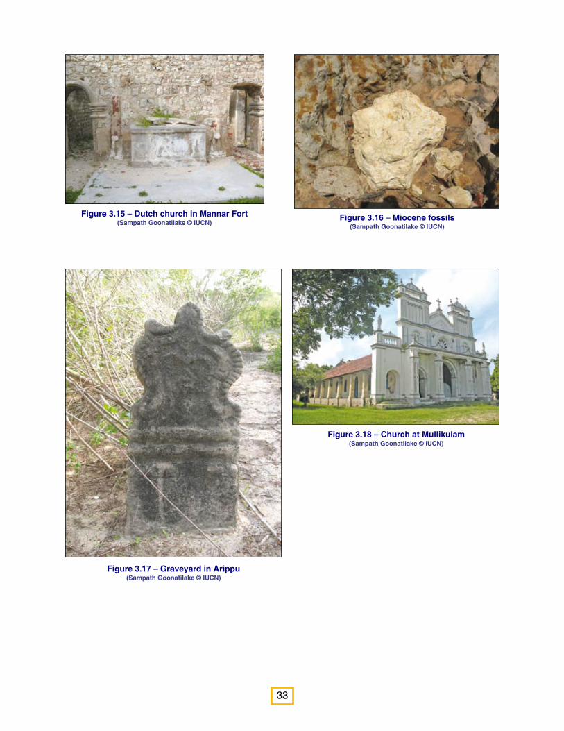
Figure 3.15 – Dutch church in Mannar Fort (Sampath Goonatilake © IUCN)
Figure 3.16 – Miocene fossils (Sampath Goonatilake © IUCN)
Figure 3.17 – Graveyard in Arippu (Sampath Goonatilake © IUCN)
Figure 3.18 – Church at Mullikulam (Sampath Goonatilake © IUCN)

34
Figure 3.19 – Arippu Dutch rest house (Sampath Goonatilake © IUCN)
Figure 3. 20 – Mantai beacon (Sampath Goonatilake © IUCN)
Figure 3.21 – Pillar inscription from Mantai (Sampath Goonatilake © IUCN)
35
Summary of Chapter 3
o Fossils of animals have been found in this region.
o Many pre-historic human settlements have been found in this area, showing Stone Age tools.
o There are several legends relating to the area, including one that says that Adam’s Bridge was built for Rama to cross, so that he could save Sita from Ravana.
o Another legend states that Prince Vijaya landed in Sri Lanka in this area.
o Another legend says that Queen Allirasani ruled in the Kalpitiya area.
o Colonists such as Portuguese, Dutch and British left their mark in the area: there are several forts and churches.
Chapter 4 - The Importance of the Natural Wealth in the Gulf of Mannar Region.
The Gulf of Mannar and its surroundings have great natural wealth (See Chapter 2). This wealth provides the people of the area with a range of benefits.
Plants, animals and ecosystems provide humans with a whole range of benefits. They give a range of services (benefits) — such as giving us food and fuel, protecting us from the floods and famines, improve the climate, purifying our waters, clean our soils of poisons and sustaining our lives. Often, ecosystems are quite simply beautiful.
4.1 Providing us with food, firewood, shelter and other goods:
Animals:It is estimated that nearly 30 million of the poorest human populations in the world depend entirely on coral reefs for their food. Mangroves are very important because they are nursery grounds for many commercially important fin and shell fish: many larvae and young fish are found in mangroves. It is estimated that up to 80% of global fish catches are directly or indirectly dependent on mangroves.
There are many different kinds of plants and animals that are eaten as food. There are 88 different kinds of fish that are caught in sea of the region. Several prawns and crabs are also popular catches.
Many important fin and shell fish are found living in seagrass meadows. Seagrass meadows, like mangroves, are nursery areas for many finfish and shellfish.
Plants: Plants provide many kinds of food:o Trees such as Vilatti (English: Woodapple; Sinhala: Divul; Scientific name: Limonia
acidissima) and Naval (Sinhala: Madan; Scientific name: Syzygium cumini) have fruit which can be eaten.
o Pakal (Sinhala: Batu-karavila; Scientific name: Momordica charantia) and Paluppakal (Sinhala: Thumba-karavila; Scientific name: Momordica dioica) are popular vegetables.
o Green leaves of Nirmulli (Sinhala: Neeramulliya; Scientific name: Hygrophila schulli), Kodi-palai (Sinhala: Anguna; Scientific name: Wattakaka volubilis) and Kovvai (English: Ivy Gourd; Sinhala: Kowakka; Scientific name: Coccinia grandis) are used as leafy vegetables.
36
An ecosystem has a variety
of different kinds of plants,
animals and micro-organisms
— depending on each other
and interacting with each
other, in a specific habitat,
with a given set of physical
variables (for example,
temperature, rainfall and soil)
to form a natural unit.
A habitat is where plants and
animals live. It is like their
home.

37
Figure 4.1 – Medicinal plants — Aloe vera(Kumudini Ekaratne © IUCN)
Some plants of the area are used for medicinal purposes:
o Avarai (English: Matara Tea; Sinhala: Ranawara; Scientific name: Senna auriculata),
o Vembu (English: Margosa; Sinhala: Kohomba; Scientific name: Azadirachta indica) and
o Kappilai (Sinhala: Pupula; Scientific name: Vernonia zeylanica), Kattoddi (Sinhala: Sudu-welangiriya; Scientific name: Capparis zeylanica) are some examples found in the area.
Some plants provide timber:
o Karunkali (English: Ebony; Sinhala: Kaluwara; Scientific name: Diospyros ebenum);
o Muritai (English: Satinwood; Sinhala: Burutha; Scientific name: Chloroxylon swietenia) provide valued timber.
Tropical dry-mixed evergreen forests, tropical thorn forests and mangroves are not only sources of food and timber but also of wood for construction and firewood.
38
Figure 4.3 – Sand dunes at Nadukuda (Sampath Goonatilake © IUCN)
Figure 4.4 – Mangroves at Palakamunai(Sampath Goonatilake © IUCN)
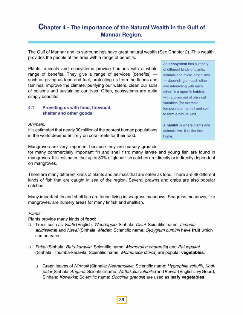
Panai Maram (English: Palmyrah; Sinhala: Thal; Scientific name: Borassus flabellifer) is a very valuable tree found
in the area. It has many uses. The soft inside of young fruits is called nungu and is eaten. The inside of the ripe
fruits — pannam palam — is sweet and can be eaten or made into juice. Sweets made from the fruits are called
panankai paniarum. The sap of the bunches of flowers is tapped to obtain toddy; fermented toddy yields arrack.
Boiling down toddy yields palmyrah jaggery or pannan katti.
Palmyrah roots are boiled and eaten as kotta kelangu and are a good source of starch. The boiled and dried root
— called odiel — is powdered and used to make kool — a traditional seafood soup.
Leaves are used for roofing, the leaf stalk for fencing and the trunk for timber.
Figure 4.2 – Palmyrah trees (Sampath Goonatilake © IUCN)
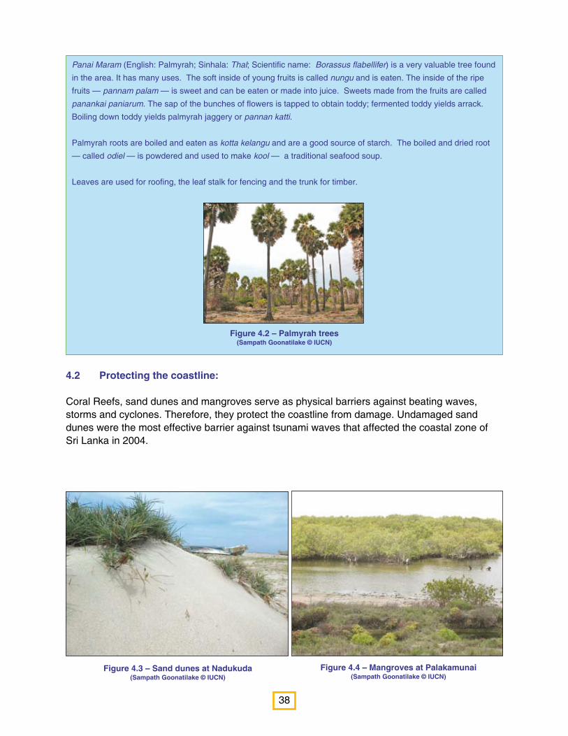
4.2 Protecting the coastline:
Coral Reefs, sand dunes and mangroves serve as physical barriers against beating waves, storms and cyclones. Therefore, they protect the coastline from damage. Undamaged sand dunes were the most effective barrier against tsunami waves that affected the coastal zone of Sri Lanka in 2004.

39
Figure 4.5 – Seagrass meadows(© Terney Pradeep Kumara)
4.3 Preventing floods:
In tropical dry-mixed evergreen forests there is always a layer of leaf litter that serves as a sponge to absorb water from falling rain, and to release it slowly into the ground. In doing so, these forests help prevent floods.
The mud in mangroves also serves to soak up and hold rain water, again preventing floods. Depending on whether they have been damaged or not, mangroves absorb the energy of the ocean waves.
Mud flats, like mangroves soak up and hold rain water, also preventing floods.
Sand dunes also prevent flooding inland.
4.4 Preventing erosion:
In the process of preventing floods, tropical dry mixed evergreen forests also prevent the soil from washing away — erosion, because of the leaf litter on the ground.
Seagrass meadows hold down the sand at the bottom of shallow seas and therefore stabilise the sea floor.
Mangroves and mud flats, in the process of preventing floods also prevent erosion.
Sand dune vegetation traps sand and prevents it from being blown further inland, and therefore, prevents erosion inland.
4.5 Trapping pollutants:
Mangrove roots also function as filters to strain out pollutants that reach the sea from waters inland. Therefore, they help improve the quality of water reaching ecosystems in the sea, in particular, ecosystems such as coral reefs.
Like mangroves, seagrass meadows also act as filters for coastal waters.

40
4.6 Regulating the local climate
Tropical dry mixed evergreen forests and tropical thorn forests play a role in regulating local climate. Because the crowns of their trees form a large area of shelter from the sun, they provide shade to local villages.
4.7 Producing food
Through the process of photosynthesis, green plants and many green algae make their own food, and serve as the base on which most other life on earth is supported. Therefore, they are called primary producers. Tropical dry mixed evergreen forests, tropical scrublands, mangroves, coral reefs, seagrass meadows are large areas of primary production and serve to support a large range of animal life within their habitats.
4.8 Trapping carbon dioxide
Through the process of photosynthesis, green plants and algae take in carbon dioxide from the atmosphere and as a by-product of this process, release oxygen into the air. As they breathe, they take in oxygen and release carbon dioxide into the air as we do. However, the net effect is that they absorb more carbon dioxide than they release. Therefore, they are called carbon sinks.
Tropical dry mixed evergreen forests, tropical scrublands, mangroves and seagrasses are all carbon sinks. It is estimated that mangroves trap large amounts of carbon, approximately 25.5 million tonnes of carbon every year. A single acre of sea-grass is estimated to produce over nine tonnes of leaves per year. All this provides a huge amount of food for many animals.
4.9 Maintaining soil productivity
Soil supports the growth of plants. Therefore, soil must contain the basic nutrients necessary for plant growth — such as nitrogen, phosphorous and potassium. In natural habitats, these nutrients are cycled among the air, soil and plants. When plants and animals die and decay, this releases nutrients back into the soil.
Decaying organic matter from mangroves is broken down into free nutrients that are washed away to the sea. This makes coastal food webs better, and with it, coastal fisheries.
The same happens in seagrass meadows and in mud flats.
On land, the same process happens in tropical dry mixed evergreen forests and in tropical scrublands.
Different soil types are found in the area. Limestone is common in the coast line from Puttalam to Jaffna, clay in Murukkan and mineral sands such as ilmenite in Pesalai.
41
Figure 4.6 – Elephant (Elephas maximus)(Sampath Goonatilake © IUCN)
Figure 4.7 – Leopards (Panthera pardus kotiya)(Sampath Goonatilake © IUCN)
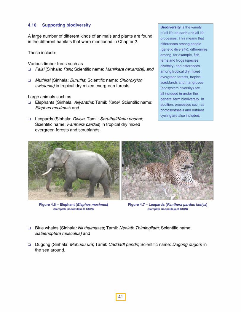
4.10 Supporting biodiversity
A large number of different kinds of animals and plants are found in the different habitats that were mentioned in Chapter 2.
These include:
Various timber trees such as o Palai (Sinhala: Palu; Scientific name: Manilkara hexandra), and
o Muthirai (Sinhala: Burutha; Scientific name: Chloroxylon swietenia) in tropical dry mixed evergreen forests.
Large animals such as o Elephants (Sinhala: Aliya/atha; Tamil: Yanei; Scientific name:
Elephas maximus) and
o Leopards (Sinhala: Diviya; Tamil: Seruthai/Kattu poonai; Scientific name: Panthera pardus) in tropical dry mixed evergreen forests and scrublands.
Biodiversity is the variety
of all life on earth and all life
processes. This means that
differences among people
(genetic diversity); differences
among, for example, fish,
ferns and frogs (species
diversity) and differences
among tropical dry mixed
evergreen forests, tropical
scrublands and mangroves
(ecosystem diversity) are
all included in under the
general term biodiversity. In
addition, processes such as
photosynthesis and nutrient
cycling are also included.
o Blue whales (Sinhala: Nil thalmassa; Tamil: Neelath Thimingilam; Scientific name: Balaenoptera musculus) and
o Dugong (Sinhala: Muhudu ura; Tamil: Caddadt pandri; Scientific name: Dugong dugon) in the sea around.

42
Figure 4.8 – Common Redshank at Vankalai mud flat(Sampath Goonatilake © IUCN)
Figure 4.9 – Kraals and traps(Sampath Goonatilake © IUCN)
Many different kinds of animals come near villus to drink water. These include:
o Mugger crocodiles (Sinhala: Hala Kimbula; Tamil: Kulathi Muthalei; Scientific name: Crocodylus palustris);
o Golden Jackals (Sinhala: Nariya; Tamil: Kulla narie; Scientific name: Canis aureus); and
o Wild Boar (Sinhala: Wal Oora; Tamil: Pandri; Scientific name: Sus scrofa).
Many different kinds of water birds stop at mud flats while migrating. These include:
o Common Sandpipers (Sinhala: Podu Siliththa; Tamil: Kottan; Scientific name: Actitis hypoleucos); and
o Common Redshanks (Sinhala: Podu Rathpa Silibilla; Tamil: Malai-kottan; Scientific name: Tringa totanus).
4.11 Supporting traditional livelihoods:
Mangroves, coral reefs and seagrass meadows support traditional fisheries such as kudu (traps) and kraal fisheries.
43
Summary of Chapter 4
Plants and animals and ecosystems provide humans with a whole range of benefits. Such as
o Providing us with food, firewood, shelter and other goods;
o Protecting the coastline;
o Preventing floods;
o Preventing erosion;
o Trapping pollutants;
o Regulating the local climate;
o Producing their own food;
o Trapping carbon dioxide;
o Maintaining soil productivity;
o Maintain biodiversity;
o Supporting traditional livelihoods;
o Providing archaeological and cultural significance ; and
o Providing relaxation and learning.
4.12 Providing archaeological and cultural significance
Chapter 3 described the archaeological and cultural significance of the region.
4.13 Providing relaxation and learning
Mangroves and coral reefs help people to learn about the environment.
Beaches are popular for relaxation.
Closed for security reasons during the war, Wipattu National Park has been reopened for visitors since the war was ended, and is a popular place for seeing elephants, leopards and sloth bears (Sinhala: Walaha; Tamil: Karadie; Scientific name: Melursus ursinus).
Ecosystems, therefore, provide humans with a wide range of benefits that ultimately affect their health and well-being. For example, having enough food ensures good health; being protected from bad weather ensures personal security.

44
Pearls come from Pearl Oysters. Oysters are
relatives of snails and slugs that live in water. Their
bodies are covered by two shells connected by a
bit of elastic ligament. Between the shell and the
oyster’s body is the mantle, which makes the shells.
When something small like grain of sand gets
between the shell and the mantle, it irritates the
oyster, rather like a scratch on the skin. The mantle
then produces some liquid to cover up this irritation.
Therefore, a small blob forms round the grain of
sand, and this becomes bigger and bigger, until a
pearl is formed.
Pearls are popular jewels. In ancient times, pearls
were believed to be special: Indian believed that
Gods turned dew into pearls; Persians believed
that pearls were a gift from God; and the Chinese
believed that pearls were created by the power of
the moon.
Pearls are referred to in the Bible, the Koran and
the Mahabharata, all praising the purity of pearls.
Extinction is a process by which groups of animals or plants die out. When this happens, the world loses that particular animal or plant. For example, dinosaurs became extinct about 65 million years ago. Now, there no longer are any dinosaurs in the world. Although the extinction is a natural process, human have greatly increased the rate of extinction so that extinction is happening extremely fast now, and many animals and plants are becoming extinct as a result of human actions.
Chapter 5 - What is happening to the Natural Wealth in the Gulf of Mannar Region?
Although the region of the Gulf of Mannar is rich with natural wealth, this natural wealth is also threatened by many human activities. In this chapter, these threats will be discussed in detail.
5.1 Overexploitation
Humans simply take too much from their natural environment. Animals and plants need to grow and breed. However, sometimes humans catch (or harvest) these animals and plants before they have had time to breed and grow. When this happens repeatedly, there are not enough to catch the next time. When too much is taken for too long, the end result is that nothing or little is left.
o Perhaps the best example of overexploitation is the Pearl Fisheries of the Gulf of Mannar.
The pearl beds (areas where pearl oysters were found) of the Gulf of Mannar are mentioned in historical records as early the 6th century BC. Traders from India, Persia and Arabia fought to own these pearl beds. In 1294, Marco Polo visited the Gulf of Mannar and noted that as many as 500 ships and boats would come during the time of harvest, with divers and traders, all searching for pearls. These traders had to pay 10% of what they earned to the King.
During the colonial times, from the 16th century, the pearl beds belonged to the government, which rented the beds to divers and traders. By 1881, however, the then government noted that although the pearl fisheries that year had been the most successful for 67 year, there were no more supplies of oyster for the next year. By 1924, a law regulating pearl fisheries was established, but it was too late: there were no more pearl oysters.
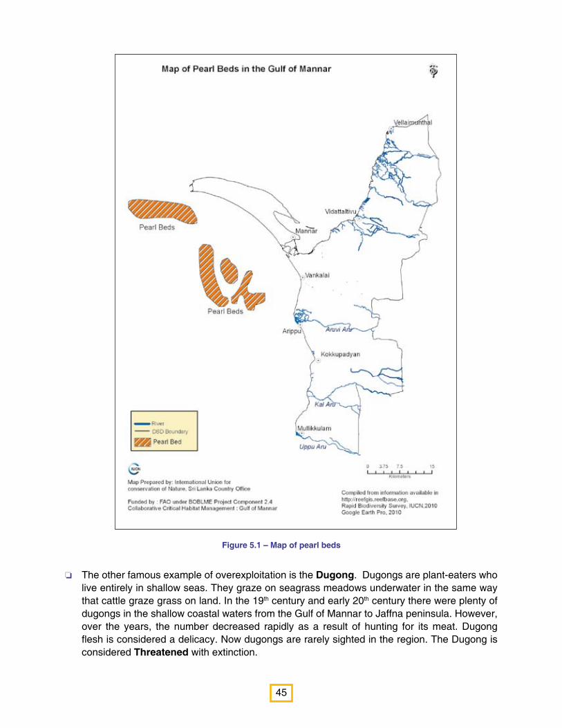
45
o The other famous example of overexploitation is the Dugong. Dugongs are plant-eaters who live entirely in shallow seas. They graze on seagrass meadows underwater in the same way that cattle graze grass on land. In the 19th century and early 20th century there were plenty of dugongs in the shallow coastal waters from the Gulf of Mannar to Jaffna peninsula. However, over the years, the number decreased rapidly as a result of hunting for its meat. Dugong flesh is considered a delicacy. Now dugongs are rarely sighted in the region. The Dugong is considered Threatened with extinction.
Figure 5.1 – Map of pearl beds
46
IUCN-International Union for the Conservation of Nature is a global organisation that measures whether animals and plants are facing extinction due to various causes. Every year, it produces a Red List that lists all the animals and plants that are threatened with extinction. Depending on the level of threat, the IUCN Red List notes seven categories. However, in this module, we will concentrate on only three of these categorieso Critically Endangered;o Endangered; and o Vulnerable.
The three categories Critically Endangered, Endangered and Vulnerable are grouped as ‘Threatened’. In this module, we only use the term Threatened.
A short study of the region showed that there were 46 different kinds of Threatened animals, including butterflies, fish, reptiles, birds and mammals, known to be threatened in Sri Lanka. These are listed in Table 5.1. Eleven different kinds of Threatened plants were also observed in the area. These are listed in Table 5.2.
o Sea cucumbers are collected in large numbers every day. These are boiled, salted, dried, packed and sent for export. Many people, including women are involved in this process and therefore, it is an important livelihood. Yet, studies are showing that too many sea cucumbers are being collected, with the result that this fishery could also become like the pearl fishery, unless some care is taken to regulate harvest.
o Sea anemones, sea urchins and various shells are being collected for ornamental purposes without any regulation. Again, there may be over-collection.
o Mussels are collected on commercial scale in Arippu, Pallimunai and Thavulpadu.
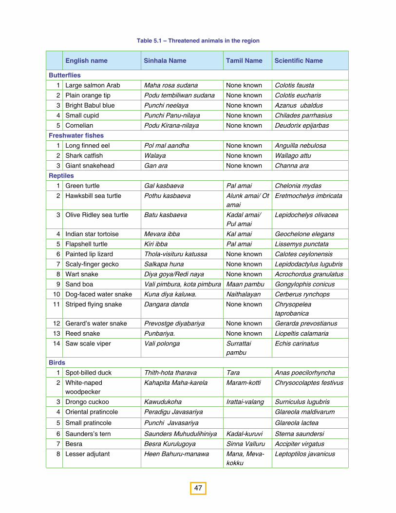
47
Table 5.1 – Threatened animals in the region
English name Sinhala Name Tamil Name Scientific Name
Butterflies1 Large salmon Arab Maha rosa sudana None known Colotis fausta 2 Plain orange tip Podu tembiliwan sudana None known Colotis eucharis 3 Bright Babul blue Punchi neelaya None known Azanus ubaldus4 Small cupid Punchi Panu-nilaya None known Chilades parrhasius 5 Cornelian Podu Kirana-nilaya None known Deudorix epijarbas
Freshwater fishes1 Long finned eel Pol mal aandha None known Anguilla nebulosa2 Shark catfish Walaya None known Wallago attu3 Giant snakehead Gan ara None known Channa ara
Reptiles1 Green turtle Gal kasbaeva Pal amai Chelonia mydas2 Hawksbill sea turtle Pothu kasbaeva Alunk amai/ Ot
amaiEretmochelys imbricata
3 Olive Ridley sea turtle Batu kasbaeva Kadal amai/ Pul amai
Lepidochelys olivacea
4 Indian star tortoise Mevara ibba Kal amai Geochelone elegans 5 Flapshell turtle Kiri ibba Pal amai Lissemys punctata 6 Painted lip lizard Thola-visituru katussa None known Calotes ceylonensis 7 Scaly-finger gecko Salkapa huna None known Lepidodactylus lugubris 8 Wart snake Diya goya/Redi naya None known Acrochordus granulatus 9 Sand boa Vali pimbura, kota pimbura Maan pambu Gongylophis conicus
10 Dog-faced water snake Kuna diya kaluwa. Naithalayan Cerberus rynchops 11 Striped flying snake Dangara danda None known Chrysopelea
taprobanica 12 Gerard’s water snake Prevostge diyabariya None known Gerarda prevostianus 13 Reed snake Punbariya. None known Liopeltis calamaria 14 Saw scale viper Vali polonga Surrattai
pambuEchis carinatus
Birds1 Spot-billed duck Thith-hota tharava Tara Anas poecilorhyncha 2 White-naped
woodpeckerKahapita Maha-karela Maram-kotti Chrysocolaptes festivus
3 Drongo cuckoo Kawudukoha Irattai-valang Surniculus lugubris 4 Oriental pratincole Peradigu Javasariya Glareola maldivarum
5 Small pratincole Punchi Javasariya Glareola lactea
6 Saunders’s tern Saunders Muhudulihiniya Kadal-kuruvi Sterna saundersi 7 Besra Besra Kurulugoya Sinna Valluru Accipiter virgatus 8 Lesser adjutant Heen Bahuru-manawa Mana, Meva-
kokkuLeptoptilos javanicus

48
English name Sinhala Name Tamil Name Scientific Name
Mammals1 Dekhan leaf-nosed bat Kesdiga Pathnehe-vavula Sinna Vava Hipposideros galeritus 2 Painted bat Visithuru Kehel-vavula Sinna Vava Kerivoula picta 3 Purple-faced leaf
monkeySri Lanka Kalu-wandura Mundi Semnopithecus vetulus
4 Jungle cat Wal Balala Kardup-poonai Felis chaus 5 Leopard Kotiya/ Diviya Sarrugu Pullie Panthera pardus 6 Rusty-spotted cat Kola Diviya / Balal Diviya Kardup-poonai Prionailurus rubiginosus 7 Fishing cat Handun Diviya Koddy-pilli Prionailurus viverrinus 8 Otter Diya-balla Neer-nai Lutra lutra 9 Sloth bear Walaha Karradee Melursus ursinus
10 Elephant Etha / Aliya Anei Elephas maximus 11 Wild buffalo Kulu Haraka Kulu madu Bubalus arnee 12 Giant squirrel Dandu-lena Malai anil Ratufa macroura 13 Hump-backed whale Molli thalmaha None known Megaptera novaeangliae 14 Blue whale Nil thalmaha Neelath
ThimingilamBalaenoptera musculus
15 Sperm whale Manda thalmaha None known Physter macrocephalus 16 Common Dugong Muhudu ura Caddadt-
pandriDugong dugon
Table 5.2 –Threatened plants in the region
English name Sinhala Name Tamil Name Scientific Name
1 None known Bu-nelu Nelu Stenosiphonium cordifolium
2 Ebony Kalu-wara Karunkali Diospyros ebenum
3 None known None known Atalai Jatropha glandulifera
4 None known Wal-kahambiliya None known Tragia plukenetii
5 None known Opulu Attukaddupulli Cynometra iripa
6 Rainforest mistletoe
Pilila Kuruvichchai Dendrophthoe ligulata
7 Rainforest mistletoe
Pilila Kuruvichchai Taxillus cuneatus
8 Anuradhapura Orchid
Rassana None known Vanda tessellata
9 None known None known Kaddumallikai Psilanthus wightianus
10 Black Mangrove Keera Kadol None known Scyphiphora hydrophyllacea

49
o When the catch is handled carelessly and handled roughly, the quality of the fish becomes bad, and there is a lot of wastage. Usually the whole catch is emptied on to the ground beside the causeway and the prawns and edible fin fish are sorted out. Fish that are not eaten are left on the ground beside the main road. This not only causes waste, but also pollution of the area.
Connected with overexploitation is the way people harvest animals and plants.
Sometimes, fishermen use methods of harvesting which are illegal and damaging to the environment. o Using dynamite for fishing: Dynamite fishing or blast fishing uses dynamite to stun or kill
fish, so that they are easily collected. This type of fishing is banned and illegal because it destroys the entire habitat. However, this type of fishing is still going on from Pallimunai to Thavulpadu area.
o Using thungus nets: Thungus nets are made of nylon. Fish cannot see the nets and swim into them, sometimes becoming wounded. This means that fish that are not targeted in a catch and fish that are still growing are also caught in these nets. These nets were banned in October 2010, and people are now stopping use of these nets. However, for some poor fishermen, these are the only nets they have, and they continue to use it.
o Using brush piles for catching cuttlefish: In many areas, including Pallimunai and Vankalai, fishermen use cut mangrove branches and make brush pile to catch cuttlefish. This is a damaging practice, as it destroys mangroves.
o Using surukku nets: These nets are circular and catch large numbers of fish and even their young.
o Using SCUBA diving for collection of sea cucumber and conch shells: Permits are needed for using SCUBA (underwater) gear. No permits have been given in Mannar for the use of SCUBA gear, but businessmen employ fishermen to catch sea cucumbers and conch shells in Silavatturai. The danger is that these SCUBA divers can remain in water for a long time and collect more of these animals, threatening their survival.
o Using bottom trawling nets: Bottom trawling nets are dragged along the sea floor by a large boat or fishing trawler. This is highly damaging as it disturbs the bottom of the sea. There are about 85 trawlers in Pesalai and they have been ordered to stop using these nets.
o Push nets: Push nets damage the sea bottom and destroy animals that live on the sea floor.
There are other resources being overexploited as well. Sand mining — although illegal — is taking place. When there is sand mining, the coastline becomes eroded. Heavy beach erosion is evident in Musali and Nanaddan Divisions.
River sand mining is taking place in Aruvi aru and Parangi aru resulting sea water entering rivers.
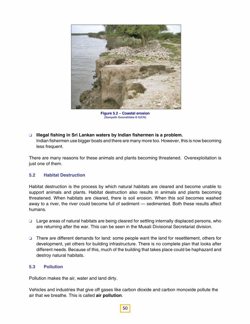
50
Figure 5.2 – Coastal erosion (Sampath Goonatilake © IUCN)
o Illegal fishing in Sri Lankan waters by Indian fishermen is a problem. Indian fishermen use bigger boats and there are many more too. However, this is now becoming
less frequent.
There are many reasons for these animals and plants becoming threatened. Overexploitation is just one of them.
5.2 Habitat Destruction
Habitat destruction is the process by which natural habitats are cleared and become unable to support animals and plants. Habitat destruction also results in animals and plants becoming threatened. When habitats are cleared, there is soil erosion. When this soil becomes washed away to a river, the river could become full of sediment — sedimented. Both these results affect humans.
o Large areas of natural habitats are being cleared for settling internally displaced persons, who are returning after the war. This can be seen in the Musali Divisional Secretariat division.
o There are different demands for land: some people want the land for resettlement, others for development, yet others for building infrastructure. There is no complete plan that looks after different needs. Because of this, much of the building that takes place could be haphazard and destroy natural habitats.
5.3 Pollution
Pollution makes the air, water and land dirty.
Vehicles and industries that give off gases like carbon dioxide and carbon monoxide pollute the air that we breathe. This is called air pollution.

51
Note that not all introduced plants
and animals are invasive, but
that all invasive alien species are
introduced.
Chemicals that are added to make crops grow faster (fertilisers) or kill pests that eat crops (pesticides) in large quantities pollute water. This is called water pollution.
Solid waste pollution refers to garbage, refuse or trash that is irresponsibly thrown away, polluting the land.
Noise pollution refers to distressing man-made noises that affect human well-being and animal life. The word ‘noise’ comes from the Latin word ‘nauseas’, meaning seasickness! The main problems of pollution in the Gulf of Mannar region come from solid waste pollution and water pollution.
Solid waste pollution:
o Fishermen are careless and throw fish that cannot be eaten on the shore, where it rots and smells. Near fish landing sites, this solid waste is quite unpleasing. This is seen in almost every fish landing site
o There is no proper disposal of solid waste in the area, except in Kalpitiya where a project for recycling wastes has just been begun. In Mannar Town garbage dumping is visible.
Water pollution:
o When farmers cultivate, they add fertilisers and pesticide that pollute rivers and streams. In Kalpitiya, there is a lot of cultivation of vegetables — which are then transported to Colombo. Studies have shown that there is a high level of nitrogen pollution in the ground water of Kalpitiya. In 225 drinking wells tested concentrations of nitrogen higher than what is acceptable for good health were found. This is causing people to fall ill.
o When this polluted water reaches habitats such as mudflats, they become contaminated and less habitat is then available for migrating birds.
o Another problem of pollution arises from cultivation of tank beds during the dry season. When fertilisers and pesticides are added for this cultivation, they can affect the quality of the water when the tank fills during the rains.
5.4 Invasive Alien Species
Some plants, like tea, rubber and coconut, are introduced into Sri Lanka. Tea, rubber and coconut do not spread aggressively, and remain in the areas they are cultivated. However some introduced plants — such as Nayunni (English Lantana; Sinhala: Ganda pana; Scientific name: Lantana camara) — will spread aggressively overtaking the areas covered with native plants, causing damage to the habitat. Such plants are called Invasive Alien Species (plants in this case). Similarly there are Invasive Alien Species of animals as well. Both invasive alien plants and animals can cause huge damage to the habitat and therefore this affects human well-being.

52
Figure 5.3 – The existing and planned shipping routes.
Sethusamudram is taken from
the Sanskrit words sethu for
bridge and samudra for sea. It is
the sea between south India and
Sri Lanka. It includes the Gulf
of Mannar, the Palk Strait, and
Adam’s Bridge.
o Valikkathan/karuvelum (English: Mesquite; Sinhala: Kalapu andara; Scientific name: Prosopis juliflora), an invasive alien plants that are rapidly invading all coastal areas and replacing natural coastal vegetation. This is one of the biggest threats to coastal vegetation.
o In the tanks and rivers of the area, is the Snakeskin Gourami (Sinhala: Vel gurami; Trichogaster pectoralis) that has been identified as an invasive alien species. This fish probably competes for food and space.
o Salvinia which is an invasive species in the Giant’s tank.
5.5 The Sethusamudram Ship Canal Project and the proposed oil exploration in the Gulf of Mannar
Adam’s Bridge is not deep — at most 3 m in depth. Because of this, at present, ships coming along the western coastline of India have to travel right round Sri Lanka in order to reach the eastern coast of India. As far back as 1860, there was a proposal that a canal should be dug across Adam’s Bridge to allow ship to pass between India and Sri Lanka, instead of going round. In 2005, the Indian Government began a project to dig a 35 km canal across Adam’s Bridge (while removing 48 million cubic meters of dredged material) and another a 54 km stretch across Palk Straight (removing 34.5 million cubic meters of dredged material. This will reduce the distance that ships have to travel by 780 km nearly three days of travel time. However, the Government of India has suspended work on this project.
53
Ecology is the study of how
organisms relate to each other
and with their environment.
In addition, the Sri Lankan government has begun oil exploration in the Gulf of Mannar. There is a possibility that both these activities may affect the marine and coastal environment. The important considerations are as follows:
o Dredging the canal is likely to disrupt the normal movement of water across Adam’s Bridge. Digging a deep canal could change the amount of water that is exchanged every season from the Gulf of Mannar to Palk Strait and Palk Strait to the Gulf of Mannar, as well as changing warmth and saltiness in the water moving back and forth. The effects of such changes on marine life and the food web in this area need to be studies carefully. It is to be noted that coral reefs are especially sensitive to even the smallest changes in temperature
o Changing the depth of this shallow area of sea could change the amount of sunlight reaching the bottom. Dredging could cause cloudiness in the water reducing the amount of sunlight reaching below. Seagrasses and coral reefs — both of which are dependent on sunlight — could also die.
o Dredging also affects organisms that live in the water near the mud — demersal organisms, as well as organisms that live in the mud — benthic organisms.
o Disposal of dredged materials needs to be examined scientifically. Sometimes, mud that is excavated may contain toxic materials.
o Other potential issues are noise pollution due to dredging (which may affect animals), pollution due to shipping accidents and oil exploration, disturbances to fishery practices and loss of fishery, particularly conch shell collection.
Both the Sethusamudram canal project and the oil exploration project are likely to have long-term, unknown effects on the ecology of the area which calls for adequate precautions to be taken in designing and implementation of the projects.
5.6 Climate change
Carbon dioxide and methane — two common gases in air form a layer in the atmosphere and allow sunlight to come in but stop some of the heat generated with that sunlight from going back into the atmosphere. During the last century and this century, too much carbon dioxide and methane has been put into the air. Vehicles and industries add carbon dioxide; collection of solid adds the production of methane. Because of this, more and more heat is being trapped and is warming the Earth. This is called Global Warming. Global warming is causing huge changes in the climate and this is called Climate Change. One of the impacts of climate change is that glaciers are melting. When glaciers melt, sea levels rise. Current sea level rise has happened at an average rate of 1.8 mm per year for the past century.
Coastal areas are the most exposed to sea level rise. Much of the coastline of the region will be threatened by climate change.
54
Summary of Chapter 5
o Although the region of the Gulf of Mannar is rich with natural wealth, this natural wealth is also
threatened by many human activities.
o Overexploitation is taking too much from the natural environment. The pearl fisheries of Sri
Lanka collapsed because of overexploitation. Dugongs have been killed for their meat and
are now Threatened with extinction.
o Forty six different kinds of Threatened animals, including butterflies, fish, reptiles, birds and
mammals are found in this region.
o Eleven different kinds of Threatened plants were observed in the area.
o Some current practices of collecting sea cucumbers, sea urchins and sea anemones could
lead to overexploitation.
o Fishermen waste a lot of fish from their catch.
o Some fishermen use dynamite for fishing, thungus nets, brush piles, surukku nets, and bottom
trawling nets which are destructive and illegal.
o Illegal fishing in Sri Lankan waters by Indian fishermen is a problem.
o Habitat destruction is another threat to the environment. Large areas of natural habitats are being
cleared for settling internally displaced persons and there are different demands for land.
o Solid waste pollution is a problem in the area as fishermen are careless and throw fish that
cannot be eaten on the shore. Also, there is no proper disposal of solid waste in the area.
o When farmers cultivate, they add fertilisers and pesticide that poison rivers and streams. This
has affected the ground water in Kalpitiya.
o Prosopis juliflora, an invasive alien plant is rapidly invading all coastal areas and replacing
natural coastal vegetation. This is one of the biggest threats to coastal vegetation.
o The proposed Sethusamudram Ship Canal Project and oil exploration in the Gulf of Mannar
may have adverse effects on the coastal and marine environment of the Gulf, and these
initiatives need more scientific studies.
o Coastal areas are the most exposed to sea level rise. Much of the coastline of the region will
be threatened by climate change.
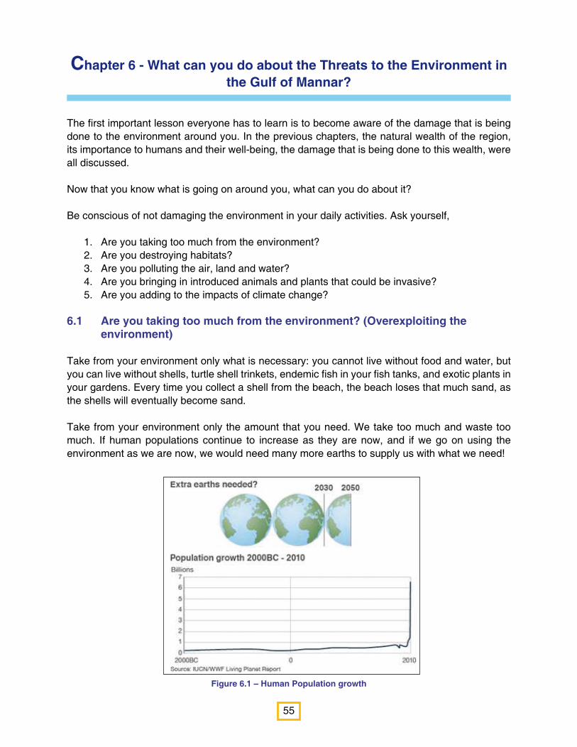
55
Figure 6.1 – Human Population growth
Chapter 6 - What can you do about the Threats to the Environment in the Gulf of Mannar?
The first important lesson everyone has to learn is to become aware of the damage that is being done to the environment around you. In the previous chapters, the natural wealth of the region, its importance to humans and their well-being, the damage that is being done to this wealth, were all discussed.
Now that you know what is going on around you, what can you do about it?
Be conscious of not damaging the environment in your daily activities. Ask yourself,
Are you taking too much from the environment? 1. Are you destroying habitats?2. Are you polluting the air, land and water?3. Are you bringing in introduced animals and plants that could be invasive?4. Are you adding to the impacts of climate change? 5.
6.1 Are you taking too much from the environment? (Overexploiting the environment)
Take from your environment only what is necessary: you cannot live without food and water, but you can live without shells, turtle shell trinkets, endemic fish in your fish tanks, and exotic plants in your gardens. Every time you collect a shell from the beach, the beach loses that much sand, as the shells will eventually become sand.
Take from your environment only the amount that you need. We take too much and waste too much. If human populations continue to increase as they are now, and if we go on using the environment as we are now, we would need many more earths to supply us with what we need!

56
6.2 Are you destroying natural habitats?
o Every time you carelessly uproot a seedling or trample one, you are destroying a tree that is part of an ecosystem. Weeds can certainly cause problems in a garden or on cultivated land, but be careful that you do not destroy plants that are not weeds.
o Always use both sides of paper when writing and drawing,
o Ask your principal and plant a tree in the school yard, every time you see one being cut down somewhere else.
o Ask your principal and plant trees and shrubs in your school that will attract butterflies and birds. In this way, you can create a little natural habitat inside your school!
o Tell people that you know about the benefits you lose when you cut down forests and fill up wetlands (you learned this in Chapter 4).
o Did you know that tropical rainforests,
which cover 6-7% of the earth’s surface,
contain over half of all the different kinds of
plants and animals in the world?
o Central America has 50% of its rainforests
remaining.
o South America has 70% of its rainforests
remaining.
o The Philippines have lost 90% of its
rainforests.
o Madagascar has lost 95% of its rainforests.
o Sri Lanka had 84% forest cover in 1881,
now it has only 23.88%.
People think that wetlands — salt marshes,
mud flats and mangroves — are of no use and
are really wastelands, when in fact they are not.
Experts agree that nearly 50% of the world’s
wetlands have been destroyed.
Every year, more than 1.1 billion trees are cut
down for just office use. Each tree on average
produces 173 reams of paper. Each ream of
paper is equal to roughly 12 pounds of carbon
dioxide not removed from the atmosphere,
adding to climate change. Each tree cut down
reduces the basic food produced on earth and
increases floods and erosion.
It takes only 2-3 weeks for a banana skin to
decay, but 100-1000 years for a plastic bag to do
so. Plastic not only causes waste management
problems but also ecological problems. It is
reported that, every year, plastic bags kill about
100,000 whales, sea turtles, and other marine
animals (many of which are Threatened), often
by choking them. Plastic bags resemble edible
squid and jellyfish.
Grow a butterfly-friendly garden
o Grow nectar plants for adult butterflies. Shrubs such as Ixora (Sinhala: Ratmal/Rathambala; Tamil: Vedchi; Scientific name: Ixora coccinea) Mussaenda, Shoe Flowers (Sinhala: Vada mal; Tamil: Shevarathai; Scientific name: Hibiscus rosa-sinensis); Blue Snakeweed (Sinhala: Balu nakuta; Tamil: Nayuruvi; Scientific name: Stachytarpheta jamaicensis), and Keerai.
o Grow other types of plants for caterpillars to eat. Certain butterflies lay their eggs on certain plants — these are called host plants. Citrus, Erukkalai (Sinhala: Wara; Scientific name: Calotropis gigantea), Custard Apple (Sinhala: Anona, Sini-aththa; Tamil: Sita pallum/Annamunna; Scientific name: Annona squamosa); Passion fruits (Sinhala: Wel dodang;Tamil: Koditoddai; Scientific name: Passiflora caerulea) and Malla-kulli /Sathai karanchan (Sinhala: Akkapana; Scientific name: Kalanchoe pinnata) will provide food for caterpillars.
o Your butterfly garden must have both sunny areas and shady areas.
o Do not use chemical sprays in your garden. Butterflies will die.
Attracting birds is simple. Just grow a Jam Fruit tree (Sinhala: Jam gaha; Tamil: Jam maram; Scientific name: Muntingia calabura) in your school garden and many birds will come to eat the fruits.

57
6.3 Are you polluting the air, land and water?
o Every time you spray chemicals with an aerosol, you are polluting the air. For protection from mosquitoes, try home remedies such Citronella oil.
o Every time fertilisers are used, these chemicals pollute the water. Persuade your parents to use natural fertilisers — such as cow dung and compost — as far as possible.
o Are you careless with trash? When you eat a toffee, do you just throw the wrapper anywhere? Learn to dispose of your waste responsibly.
o Are you buying unnecessary plastic? When you go to a shop, do you come back with many plastic shopping bags? Instead of using shopping bags, switch to using cloth bags instead.
o If you stop using 10 bags a month, you will save the use of 120 bags a year. If there are four people in your family, you will save the use of 480 bags per year. If you do this for only 10 years, your family will save the use of 48,000 bags. Think of how many you can save the use of in a lifetime and how much a whole town can save.
o Are you keeping the beaches in your area clean? Ask your principal, and try to organise a shramadana to clean one stretch of beach near your school and then make sure that it is kept clean.
o Every time you are careless about solid waste, chemicals or with aerosols, remember that you are polluting the Gulf of Mannar and its environment that is rich with natural wealth.
Urban and developed areas can produce an
enormous amount of solid waste. In Asia, it is
estimated that urban areas produce 760,000
tonnes of waste daily, and this is predicted to
increase by 2025 to 1.8 million tonnes per day.
Sri Lanka is estimated to produce 0.89kg per
person per day of municipal solid waste. Apart
from looking ugly, solid waste increases the
breeding spots of many disease carriers —
such as mosquitoes and rats — and therefore,
increases the spread of disease. Solid waste
can also wash into waterways, causing water
pollution and contaminate ground water. It also
generates methane, a gas which like carbon
dioxide, contributes to global warming.
Start a solid waste programme in your school.o Learn to reduce, recycle and reuse materials.
o Reduce use of paper (you are using something made from a tree). Reduce the use of plastic.
o Reuse paper, bags and bottles without throwing them away.
o Recycle glass, tin, paper and plastic.
o Have separate bins for paper, tin, glass and wet waste (remnants of food etc.) Teach the school
children to use these separate bins for separate items and not to litter the school.
o Collect garden waste, eggshells, coffee grinds and tea leaves and start a compost bin or pit. Compost
provides good, nutritious natural fertiliser. You can try composting at home too.

58
In Sri Lanka, the net use of electricity doubled between 1992 and 2002.
l Each small leak wastes a lot of water.
A leak that fills up a coffee cup in 10
minutes will waste over 11,000 litres of
water a year.
l If you leave the water running while
brushing your teeth you will waste nearly
19 litres of water — that is enough to fill
80 tea cups
6.4 Are you bringing in introduced animals and plants that could be invasive?
You have learned about the dangers of invasive alien species. It is always best to plant native plants in your garden than experiment with introduced species. It is always best to have standard goldfish, guppies and plates in your fish tank than more exotic fish.
6.5 Are you adding to the impacts of climate change?
You can reduce the impacts of climate change by reducing the amount of carbon dioxide emissions — this is called mitigation. Whenever we waste electricity or burn things, we are releasing more carbon dioxide into the air. By planting trees we can increase the amount of carbon dioxide absorbed.
Climate change adaptation simply means adjusting your life to deal with the effects of climate change: being careful about our use of water, being responsible about solid waste, preventing chemical and air pollution, are all ways of adapting to climate change.
o Are you conscious about reducing energy use — do you put out lights and fans when you are not in the room?
o When you cook, do you boil food in a large volume of water in open saucepans or do you use the minimum quantity of water and a closed pan?
o Do you burn trash releasing carbon dioxide into the air? If you learn to reduce, reuse, recycle, then you won’t need to burn trash.
o Are you wasting precious water? Are you conscious about reducing use of water? Do you ignore leaking taps? Tell your parents if you see a tap leaking at home or your teacher, in school. Remember that Mannar is located in an area where water is very scarce. It is all the more important, therefore, to be very conscious that you are not wasting a drop.
o Do you leave water running when you brush your teeth? Do you leave water running when you soap yourself when bathing? Or when you wash dishes?
o Are you making an active effort to plant trees?
59
Every little change counts. Everyone’s effort, adding up, can ultimately make a big difference to our environment.
The second important thing you need to do is to persuade other people to change their habits too. Become an agent for the change that is necessary for the environment.
o Start with your school. Tell your classmates what you have learned. If each of them changes his or her habits, you will have 40 children caring for the environment. If each of them tells one more person, you will have 1,600 children caring for your environment.
o Also talk to your family and get them to change their habits in relation to the environment.
o Ask your principal and start a campaign to clean up the environment. Pick an area and have a shramadana.

60
References
The following references were used in the preparation of this module.
Bambaradeniya, C N B., M S J Perera, & V A M P K Samarawickrama (2006). A rapid assessment of post-tsunami environmental dynamics in relation to coastal zone rehabilitation and development activities in Hambantota District of southern Sri Lanka. IUCN Sri Lanka Occasional Paper No. 10. IUCN, Colombo, Sri Lanka. 27pp
Coles, R G, L J McKenzie, M Rasheed, J E Mellors, H Taylor, K Dew, S McKenna, T L Sankey, A B Carter and A. Grech (2007) Status and Trends of seagrass habits in the Great Barrier Reef World Heritage Area. Report to the Marine and Tropical Research Science Facility. Reef and Rainforest Centre Limited, Cairns. 122 pp
De Bruin, G H P, B C Russell & A Bogusch (1995) FAO species identification field guide for fishery purposes. The marine fishery resources of Sri Lanka. FAO, Rome. 400 pp. 32 Colour plates
Department of Census and Statistics (2009) Statistical Abstract http:///www.statistics.gov.lk/ Accessed Nov 27 2010
District Planning Secretariat, Mannar (2010) Statistical Hand Book Mannar District 2009. 103pp
Henry, G M (1971) A guide to the birds of Ceylon. Oxford University Press, London. 457 pp
http://en.wikipedia.org/wiki/Man_and_the_Biosphere_Programme. Accessed Nov 30 2010
http://en.wikipedia.org/wiki/Gulf_of_Mannar. Accessed Nov 26 2010
http://en.wikipedia.org/wiki/Noise_pollution. Accessed Dec 1 2010
http://www.paspaleypearls.com/english/images/pdf/pearlworld_ancient-history.pdf. Accessed Dec 1 2010
http://en.wikipedia.org/wiki/Sethusamudram_Shipping_Canal_Project#Benefits. Accessed Dec 2 2010 IUCN Red List of Threatened Species™ (2010) http://www.iucnredlist.org/ Accessed Nov 27 2010
IUCN (in preparation). A fisheries management strategy for the Puttalam Lagoon.
IUCN (unpublished document). Coastal Faunal diversity of the Gulf of Mannar. 10 pp
IUCN (unpublished document). Biodiversity of Gulf of Mannar region. 11 pp
IUCN (unpublished document). Archaeological and Cultural Significant of the Gulf of
Mannar 10 pp
Laist, D W, A R Knowlton, J G Mean (2001) Collisions between ships and whales. Marine Mammal Science, 17(1):35–75
Ong, J E (1993) Mangroves — a carbon source and sink. Chemosphere 27: 1097-1107
Panabokke, C R, R P Kannangara (1996) Map of the agro-ecological regions of Sri Lanka. Survey Department, Sri Lanka
Sethusamudram Canal Project Advisory Committee documents, undated

61
Sullivan, C (2005) The importance of mangroves http://www.vi_ shandwildlife.com/ Education/FactSheet/PDF_Docs/28Mangroves.pdf
UNEP-WCMC (2006) In the front line: shoreline protection and other ecosystem services from mangroves and coral reefs. UNEP-WCMC, Cambridge, UK. 33 pp
University of Ruhuna (unpublished document). Rapid Biodiversity Survey of
Mannar Biosphere, Sri Lanka. Consultancy report to IUCN. 69 pp
Wilkinson, C (2004) Status of Coral Reefs of the World, 2004 (Vol 1) Australian Institute of Marine Science, Townsville, Australia. xiv + 301 pp
62
Learn More
About Sri Lanka’s Habitats
IUCN and NIE (1999) Resource material on Biodiversity for General Certificate of Education (Advanced Level). IUCN, Sri Lanka. vi+ 83 pp
About Plants
ISSG Database (2009). Invasive Species Specialist Group. http://www.issg.org/database/
IUCN (2009) Mangroves: A resource book for secondary school teachers. (trilingual). IUCN, Colombo. 48pp
Kottegoda, S R (2000). Flowers of Sri Lanka. Royal Asiatic Society of Sri Lanka, Colombo. xv + 247 pp
Miththapala, S, S Wijesundara and J Galappatti (2011). Flowering plants commonly encountered in Sri Lankan habitats. National Trust: Colombo. 216 pages.
Miththapala, S and P A Miththapala (1998 and several reprints). What Tree is that? A Lay-person’s guide to some trees of Sri Lanka. Ruk Rakaganno, Colombo. 93 pp. Also available in Sinhalese and Tamil.
Pinto, L (1986). Mangroves of Sri Lanka. Natural Resources, Energy and Science Authority of Sri Lanka, Colombo. 54 pp
Ratnayake, H D and S P Ekanayake (1995). Common wayside trees of Sri Lanka. Royal Botanical Gardens, Peradeniya. 192 pp
Sumithrarachi, D B , H D Ratnayake, and S P Ekanayake (1995). Beautiful Wild flowers of Sri Lanka. Royal Botanical Gardens, Peradeniya. 154 pp
Vlas, J and J Vlas (2008). An illustrated field guide to the flowers of Sri Lanka. Mark Booksellers and Distributers (Pvt), Kandy. 304 pp
About Invertebrates
http://www.srilankaninsects.net About Butterflies and Dragonflies of Sri Lanka
Bedjanic, M, G de Silva Wijeyeratne & K Conniff (2007). Dragonflies of Sri Lanka. Gehan’s Photo Guide Series. 1st Edition. Jetwing Eco Holidays,Colombo. 252 pages. Can be downloaded at http://www.jetwingeco.com/index.cfm?mid=6&id=6

63
de Silva Wijeyeratne, G (2006, several reprints). Butterflies of Sri Lanka and Southern India. Gehan’s Photo Booklet Series. Jetwing Eco Holidays, Colombo. 26 plates. Can be downloaded at http://www.jetwingeco.com/index.cfm?mid=6&id=6
de Silva Wijeyeratne, G (2007). Butterflies of Sri Lanka and Southern India. Gehan’s Poster Series. Jetwing Eco Holidays, Colombo. Can be downloaded at http://www.jetwingeco.com/index.cfm?mid=6&id=6
de Silva Wijeyeratne, G, K Conniff & M Bedjanic (2010). Dragonflies of Sri Lanka. Gehan’s Poster Series. Sri Lanka Tourism Promotion Bureau, Colombo. Can be downloaded at http://www.jetwingeco.com/index.cfm?mid=6&id=6
About Corals
Jayasinghe, Charmalee & Shamen Vidanage (2003). Coral reefs: A resource book for secondary school teachers. (trilingual). IUCN, Colombo. 84pp
http://www.divesrilanka.com/FishCoralID.html for marine fish and coral
About Fish
http://www.divesrilanka.com/FishCoralID.html for marine fish and coral
Fernando, C H (1990). The freshwater fauna and fisheries of Sri Lanka. NARESA, Colombo 444 pp
NARA — National Aquatic Resources Research and Development Agency. Various stickers and posters are available for sale at http://www.nara.ac.lk/stickers/index2.html
About Amphibians
http://sites.google.com/site/srilankaamphibians/Home
About Reptiles
Das. I and A de Silva (2005). Snakes and other reptiles of Sri Lanka. New Holland Publishers, UK. 144 pp
http://www.srilankanreptiles.com/
About Birds
de Silva Wijeyeratne, G (2006). Birds of Sri Lanka and Southern India. Gehan’s Photo Booklet Series. Jetwing Eco Holidays, Colombo. 42 plates. Can be downloaded at http://www.jetwingeco.com/index.cfm?mid=6&id=6

64
de Silva Wijeyeratne, G (2010). Birds of Sri Lanka. Gehan’s Poster Series. Sri Lanka Tourism Promotion Bureau, Colombo. Can be downloaded at http://www.jetwingeco.com/index.cfm?mid=6&id=6
Kotagama, S and G Ratnavira (2010). An illustrated guide to the birds of Sri Lanka. FOG, Sri Lanka. 356 pp
About Mammals
de Silva Wijeyeratne, G (2010). Mammals of Sri Lanka. Gehan’s Poster Series. Sri Lanka Tourism Promotion Bureau, Colombo. Can be downloaded at http://www.jetwingeco.com/index.cfm?mid=6&id=6
de Silva Wijeyeratne, G (2008). Mammals of Sri Lanka. New Holland Publishers, UK. 128 pp


International Union for Conservation of Nature
IUCN Sri Lanka Country Office, 53, Horton Place, Colombo 07, Sri Lanka.www.iucnsl.org


