IPWEA NSW State Conference 2017 ‘Engineering, Taking NSW Forward’ Page 1 ARE THEY HAVING YOUR CAKE AND EATING IT TOO? THE HIGH COST OF RELYING ON “DUMB LUCK” GROUND MODELLING Jason Errey Director OEMG Global, NSW, Australia Anton Juodvalkis Manager Governance and Engagement, Bellingen Shire Council, NSW, Australia. Paper Summary Every decision taken by the proponent during the definition and initiation phase of a project, in some way, depends on assumptions about the structural geology at the site. More than this however, structural geology is a key element in determining the overall risk profile of the project, and a failure by the proponent to understand and own upside risk will have profound negative outcomes. Decisions such as “what is the appropriate infrastructure to suit client needs and how much will it cost?” are only part of the question as there is no consideration of the foundations, if they will work in the environment or, how the design and construct contractors will perceive risk. It is very easy to assume that detailed construction risk is for the contractors to determine and mitigate. To an extent this is true, but this perception fails to grasp both the significance and the value of the opportunities that are lost. If there is no certainty regarding the fit of the proposed infrastructure to the geological setting, then one way or another, the client will pay. This will either be through open-ended geological risk clauses or exaggerated risk provisions in a lump sum price. Particularly, larger contractors view downside risk to the client as opportunity for themselves. Just as significantly, the client loses the opportunity to tailor assets to the site, for example; adjusting pile locations to suitable geology, orienting the dredge cut to soft sediments or, being prepared for difficult conditions, can save significant time and money. Understanding the structural geology can be equally important for both major and minor infrastructure projects. Spend on ground studies should be determined by risk associated with a project as well as the value that a structural assessment of the ground may realise. In this paper we examine the cost of three projects that utilised advanced geophysics and targeted boreholes to realise opportunity risk and cost savings. Projects range from sub-million dollar road works, to a port redevelopment and the creation of a strategic ground model to understand the Gold Coast waterways for current and future development. On these projects, the creation of robust ground models has resulted in many millions of dollars in value being returned to proponents. Introduction Governments exist in a world of constrained revenue and unlimited expenses. Civil engineers are in the unenviable position of having to deliver infrastructure in an environment of rising costs and falling revenues in real terms. By looking at ground modelling as a risk identification tool at the project inception phase rather than as a risk evaluation or treatment tool, asset managers and engineers are able to minimise whole of life costs on their asset portfolios. By promoting innovation in this field, tools like the Integrated Digital Ground Model (IDGM) and Advanced Aquares Geophysics, will allow engineers to innovate and better address asset renewal backlogs.
Transcript
IPWEA NSW State Conference 2017
‘Engineering, Taking NSW Forward’
Page 1
ARE THEY HAVING YOUR CAKE AND EATING IT TOO? THE
HIGH COST OF RELYING ON “DUMB LUCK” GROUND
MODELLING
Jason Errey
Director OEMG Global, NSW, Australia
Anton Juodvalkis
Manager Governance and Engagement, Bellingen Shire Council, NSW, Australia.
Paper Summary
Every decision taken by the proponent during the definition and initiation phase of a project, in some way, depends on assumptions about the structural geology at the site. More than this however, structural geology is a key element in determining the overall risk profile of the project, and a failure by the proponent to understand and own upside risk will have profound negative outcomes. Decisions such as “what is the appropriate infrastructure to suit client needs and how much will it cost?” are only part of the question as there is no consideration of the foundations, if they will work in the environment or, how the design and construct contractors will perceive risk.
It is very easy to assume that detailed construction risk is for the contractors to determine and mitigate. To an extent this is true, but this perception fails to grasp both the significance and the value of the opportunities that are lost. If there is no certainty regarding the fit of the proposed infrastructure to the geological setting, then one way or another, the client will pay. This will either be through open-ended geological risk clauses or exaggerated risk provisions in a lump sum price. Particularly, larger contractors view downside risk to the client as opportunity for themselves. Just as significantly, the client loses the opportunity to tailor assets to the site, for example; adjusting pile locations to suitable geology, orienting the dredge cut to soft sediments or, being prepared for difficult conditions, can save significant time and money.
Understanding the structural geology can be equally important for both major and minor infrastructure projects. Spend on ground studies should be determined by risk associated with a project as well as the value that a structural assessment of the ground may realise. In this paper we examine the cost of three projects that utilised advanced geophysics and targeted boreholes to realise opportunity risk and cost savings. Projects range from sub-million dollar road works, to a port redevelopment and the creation of a strategic ground model to understand the Gold Coast waterways for current and future development. On these projects, the creation of robust ground models has resulted in many millions of dollars in value being returned to proponents.
Introduction
Governments exist in a world of constrained revenue and unlimited expenses. Civil engineers are in the unenviable position of having to deliver infrastructure in an environment of rising costs and falling revenues in real terms. By looking at ground modelling as a risk identification tool at the project inception phase rather than as a risk evaluation or treatment tool, asset managers and engineers are able to minimise whole of life costs on their asset portfolios. By promoting innovation in this field, tools like the Integrated Digital Ground Model (IDGM) and Advanced Aquares Geophysics, will allow engineers to innovate and better address asset renewal backlogs.
IPWEA NSW State Conference 2017
‘Engineering, Taking NSW Forward’
Page 2
New assets can be engineered and constructed with a greater degree of certainty around optimal solutions, budgets and time frames, whilst managing community and environmental impacts. An IDGM is a product that persists for the life of the asset and can be utilised to assist with the maintenance and upgrade programs.
When considering foundation design and earth works associated with new and existing assets, it is sobering to think that usually what has been planned, and what takes place, is not the same. In a study published by Engineering Australia, up to 50% of public infrastructure projects were found to have time or cost over-runs due to unforeseen geological conditions (Banes, 2010). What is extraordinary about this is that these failures are not only accepted, but planned for and costed into the project. By extension then, if up to 50% of projects see over-runs, and engineers, project managers and financial controllers are conditioned to expect this, it can be assumed that close to 100% of projects are over engineered or overpriced to account for these unknown risks. This impacts every aspect of asset delivery and not only increases costs, but decreases the value. Considering there is over $100Billion in currently planned or underway public works just on the east coast of Australia, the lost opportunities and ongoing cost to the economy and tax payer associated with poor ground modelling is staggering, if not crippling.
Constructing blind or relying on “dumb luck” for foundations provides no advantage or cost returns to the proponent or the community. The structure is not stronger, it will not by intention exceed the design life, but it will cost more, take longer to build and interrupt key engineering and innovation processes at the inception phase of a project. Overall, poor ground modelling will reduce funds available to the whole asset delivery and maintenance budget, yet the same ground modelling techniques are continually applied, and continually allowed to fail. We can build structures that defy the imagination, with tolerances to the centimetre, but allow uncertainties in the understanding of the geology. Ground studies appear to be prescribed and largely exist outside of the normal project management framework. Questions defining the ground study are almost never asked, such as; when should ground studies be undertaken? Who can/will use the data? What are the risks or the cost of the risk that needs to be understood? Or, what ground modelling technology will have the best return on investment irrespective of the cost to deploy it?
The majority of the tools used to study the ground are 1Dimensional or at best 2Dimensional, based on boreholes, and analogue. Currently there is no real effort to integrate the collection of ground data and use one system to corroborate the other. Innovative solutions that are cost effective in price and value are available including the Integrated Digital Ground Model and advanced 3Dimensional geophysics. However, procurement is structured in such a way as to exclude innovative approaches, either through the prescribing of technology or bundling methods. For example, simply tacking on 2Dimensional geophysics (or geophysics in general) to the back of a 1Dimensional (discrete) borehole campaign, is not integration, is not innovative and indeed can stifle innovation. Further, it is not cost effective, is unlikely to add value, and does little to validate the findings of the borehole study or increase certainty. Innovative ground modelling is a stepped process that seeks to provide geological context that is simply not possible with boreholes alone. By extension, borehole campaigns do not capture the required context for understanding and utilising upside (opportunity) risk, as well as mitigating downside risks associated with proposed infrastructure.
What is Ground Modelling and Why do it?
There is a major distinction between what ground modelling is and what it should be, resulting in missed opportunities for stakeholders and a lack of impetus for contractors to innovate. To begin to narrow this gap, both the process of ground modelling as well as the technology implemented must be examined. Generally, ground modelling is accepted as a risk abatement tool that is supposed to predict the ground conditions that may impact a proposed construction activity, however this is only half the picture. In a modern context, risk management requires that uncertainties be defined, analysed, evaluated and treated. Furthermore, risks may be upside opportunities to be capitalised on, or downside to be mitigated. However, if detailed ground
IPWEA NSW State Conference 2017
‘Engineering, Taking NSW Forward’
Page 3
modelling is undertaken after the alignment and/or infrastructure decisions are made or if ground modelling is arbitrarily prescribed, many downside risks are set and upside risks are lost. For various reasons, boreholes have become the de facto standard for defining soil types, risk and construction methods. Boreholes are 1Dimensional discrete point data, and there is an accepted belief that neighbouring boreholes may be linked together to create a continuous 2Dimensional or 3Dimensional visualisation of a site. This belief however leads to the inclusion of inherent errors of boreholes and no understanding of variations within layers. For example, it is a common and often required practice to undertake a borehole at each pile or footing location when building a bridge (Main Roads, 2009); other developments may require boreholes at set distances or randomly set out across a site.
Apart from bridge works, the minimum number and set out of boreholes is picked by the project manager. Occasionally, a project manager might choose to include a 2Dimensional geophysical survey along an alignment, but there is no fixed requirement for this. In addition, the objectives of a geophysical study and outcomes are often ill defined by the proponent and contractor. In the case that both the borehole study and geophysical works must be acquired along an alignment, usually both the type of structure and alignment has been determined prior to any physical sampling of the ground, limiting opportunities these studies can capture for proposed works. Most importantly, if a borehole is undertaken at a pile location or randomly at a site, no justification can be made to prove that those samples have captured, or allow the visualisation of, ground risk associated with the proposed works. It is this issue lies at the core of why up to 50% of public works project run over time or cost. If a ground study is undertaken at the inception stage of a project and designed to capture the geological setting, the engineer can make decisions about the alignment and the asset that is most suited to the environment and cost effective delivery of the required service.
Limitations of Ground Sampling Technology
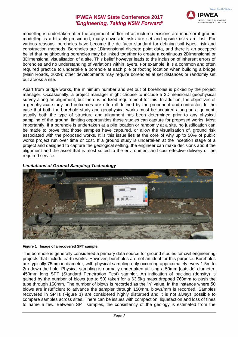
Figure 1 Image of a recovered SPT sample.
The borehole is generally considered a primary data source for ground studies for civil engineering projects that include earth works. However, boreholes are not an ideal for this purpose. Boreholes are typically 75mm in diameter, with physical sampling only occurring approximately every 1.5m to 2m down the hole. Physical sampling is normally undertaken utilising a 50mm [outside] diameter, 450mm long SPT (Standard Penetration Test) sampler. An indication of packing (density) is gained by the number of blows (up to 50) taken for a 63.5kg mass dropped 760mm to push the tube through 150mm. The number of blows is recorded as the “n” value. In the instance where 50 blows are insufficient to advance the sampler through 150mm, blows/mm is recorded. Samples recovered in SPTs (Figure 1) are considered highly disturbed and it is not always possible to compare samples across sites. There can be issues with compaction, liquefaction and loss of fines to name a few. Between SPT samples, the consistency of the geology is estimated from the
IPWEA NSW State Conference 2017
‘Engineering, Taking NSW Forward’
Page 4
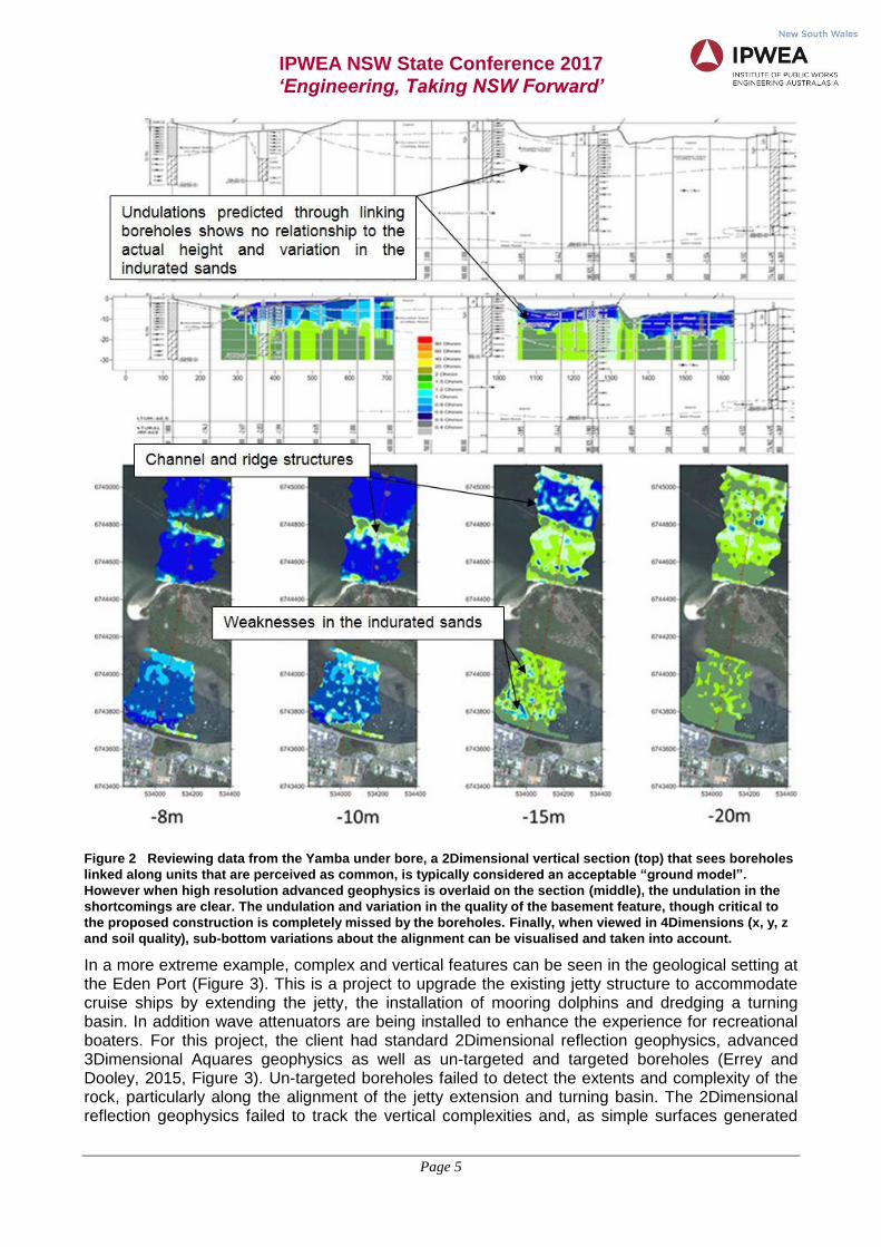
cuttings (mixed with drilling muds) being expelled from the drilling process. The vertical accuracy of boreholes must be considered therefore, to be the distance between SPT samples, that is, one to two meters. Issues with vertical accuracy and the interpretation of recovered samples lead to errors relating to connecting boreholes laterally to produce sections (Figure 2), in addition to the masking of lateral variations. Horizontal errors must also be considered, with many contractors opting to use consumer grade, hand held positioning units that have a variable accuracy of around 10m.
With inherent and uncontrolled uncertainty present in the collection of boreholes, the linkage of neighbouring boreholes through popular visualisation tools such as gINT, can result in very serious misrepresentations of the ground (Figure 2). In this example, undertaken for NSW Public Works for the Yamba Ebb Tide Release (Errey and Stewart-Rattray, 2015), it is clear that the boreholes do not allow for the visualisation of the undulations of the lower hard structure (indurated sands) and importantly, lateral variations (weaknesses) within the structure. As this study was for a proposed Horizontal Directional Drill (HDD), both these issues were critical; to manage the stability of the hole, and minimise the fracking of drilling muds. Linking of like units between boreholes added no value to the understanding of the site or project risk. Indeed, when reviewing the overlay of Advanced Aquares Geophysics, linking of boreholes likely increased risk, as the visualisation failed to identify undulations or weaknesses within the indurated sands that would have caused fracking and halted works, as was reported during the nearby Iluka HDD.
Another key, but overlooked issue is that there is often no examination of the area either side of the alignment. Generally, this is because the area along the alignment is considered most important; boreholes (particularly marine) are expensive, they take time and drill rigs can inconvenience the public. In addition, studies are often undertaken to test a pre-determined design rather than to test which design is appropriate. When advanced geophysics is undertaken however, it is at the same cost to acquire data along and about an alignment as it is to acquire data just along an alignment (Figure 2). This provides far more context for the interpretation of data. For example, a dominant east/west trending ridge can be seen along with a channel structure in the northern section and most importantly, deep imperfections within the indurated sands along the proposed alignment, that are not visible on the vertical section, are seen (Figure 2). Understanding of the location and depth of these structures allowed the proponent and contractor to determine the ideal depth of the HDD and avoid the risk of fracking and/or tunnel collapse by calculating the cost/risk opportunities of drilling at shallow or deeper depths. This captured opportunity allowed the proponent to enter into a collaborative contract and assume ground risks. In this instance the contractor was able to remove risk margins reducing the overall price to the tax payer. The value of the opportunities gained far exceeded the cost of the geophysical survey and IDGM.
IPWEA NSW State Conference 2017
‘Engineering, Taking NSW Forward’
Page 5
Figure 2 Reviewing data from the Yamba under bore, a 2Dimensional vertical section (top) that sees boreholes
linked along units that are perceived as common, is typically considered an acceptable “ground model”.
However when high resolution advanced geophysics is overlaid on the section (middle), the undulation in the
shortcomings are clear. The undulation and variation in the quality of the basement feature, though critical to
the proposed construction is completely missed by the boreholes. Finally, when viewed in 4Dimensions (x, y, z
and soil quality), sub-bottom variations about the alignment can be visualised and taken into account.
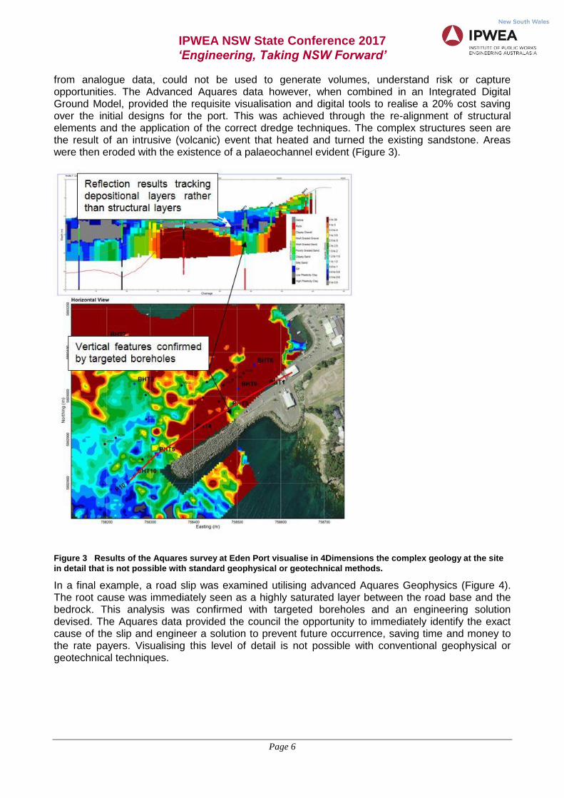
In a more extreme example, complex and vertical features can be seen in the geological setting at the Eden Port (Figure 3). This is a project to upgrade the existing jetty structure to accommodate cruise ships by extending the jetty, the installation of mooring dolphins and dredging a turning basin. In addition wave attenuators are being installed to enhance the experience for recreational boaters. For this project, the client had standard 2Dimensional reflection geophysics, advanced 3Dimensional Aquares geophysics as well as un-targeted and targeted boreholes (Errey and Dooley, 2015, Figure 3). Un-targeted boreholes failed to detect the extents and complexity of the rock, particularly along the alignment of the jetty extension and turning basin. The 2Dimensional reflection geophysics failed to track the vertical complexities and, as simple surfaces generated
IPWEA NSW State Conference 2017
‘Engineering, Taking NSW Forward’
Page 6
from analogue data, could not be used to generate volumes, understand risk or capture opportunities. The Advanced Aquares data however, when combined in an Integrated Digital Ground Model, provided the requisite visualisation and digital tools to realise a 20% cost saving over the initial designs for the port. This was achieved through the re-alignment of structural elements and the application of the correct dredge techniques. The complex structures seen are the result of an intrusive (volcanic) event that heated and turned the existing sandstone. Areas were then eroded with the existence of a palaeochannel evident (Figure 3).
Figure 3 Results of the Aquares survey at Eden Port visualise in 4Dimensions the complex geology at the site
in detail that is not possible with standard geophysical or geotechnical methods.
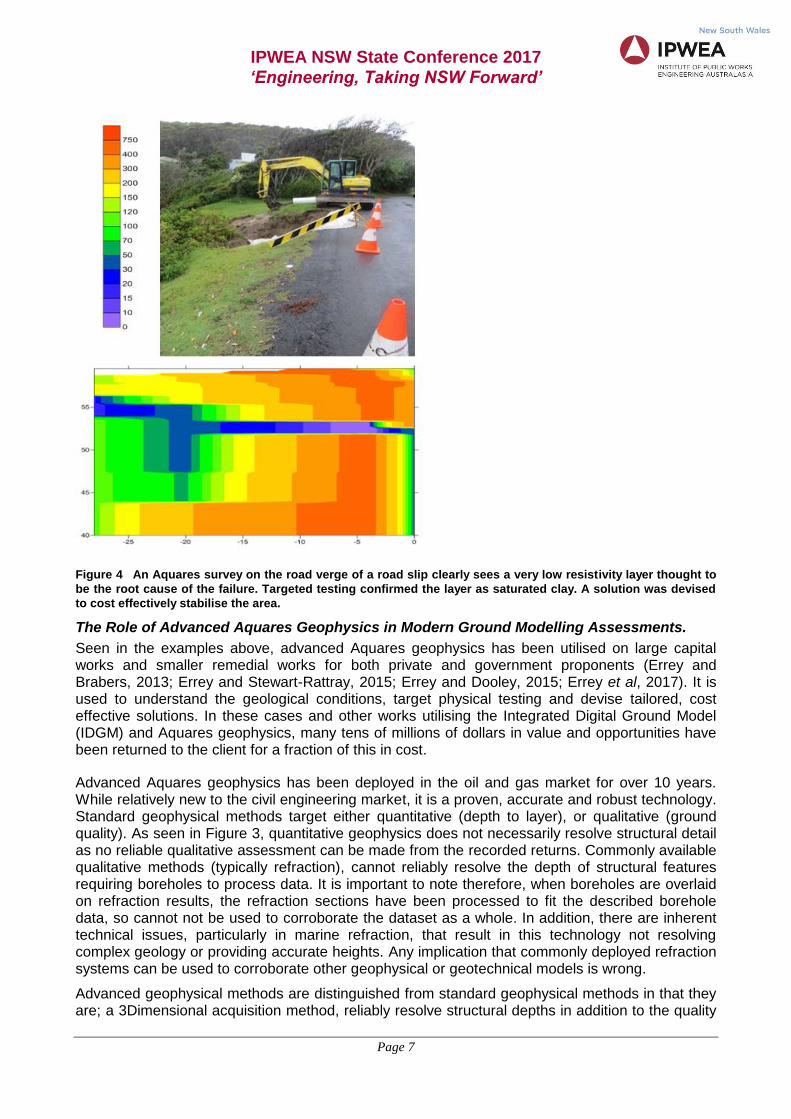
In a final example, a road slip was examined utilising advanced Aquares Geophysics (Figure 4). The root cause was immediately seen as a highly saturated layer between the road base and the bedrock. This analysis was confirmed with targeted boreholes and an engineering solution devised. The Aquares data provided the council the opportunity to immediately identify the exact cause of the slip and engineer a solution to prevent future occurrence, saving time and money to the rate payers. Visualising this level of detail is not possible with conventional geophysical or geotechnical techniques.
IPWEA NSW State Conference 2017
‘Engineering, Taking NSW Forward’
Page 7
Figure 4 An Aquares survey on the road verge of a road slip clearly sees a very low resistivity layer thought to
be the root cause of the failure. Targeted testing confirmed the layer as saturated clay. A solution was devised
to cost effectively stabilise the area.
The Role of Advanced Aquares Geophysics in Modern Ground Modelling Assessments.
Seen in the examples above, advanced Aquares geophysics has been utilised on large capital works and smaller remedial works for both private and government proponents (Errey and Brabers, 2013; Errey and Stewart-Rattray, 2015; Errey and Dooley, 2015; Errey et al, 2017). It is used to understand the geological conditions, target physical testing and devise tailored, cost effective solutions. In these cases and other works utilising the Integrated Digital Ground Model (IDGM) and Aquares geophysics, many tens of millions of dollars in value and opportunities have been returned to the client for a fraction of this in cost.
Advanced Aquares geophysics has been deployed in the oil and gas market for over 10 years. While relatively new to the civil engineering market, it is a proven, accurate and robust technology. Standard geophysical methods target either quantitative (depth to layer), or qualitative (ground quality). As seen in Figure 3, quantitative geophysics does not necessarily resolve structural detail as no reliable qualitative assessment can be made from the recorded returns. Commonly available qualitative methods (typically refraction), cannot reliably resolve the depth of structural features requiring boreholes to process data. It is important to note therefore, when boreholes are overlaid on refraction results, the refraction sections have been processed to fit the described borehole data, so cannot not be used to corroborate the dataset as a whole. In addition, there are inherent technical issues, particularly in marine refraction, that result in this technology not resolving complex geology or providing accurate heights. Any implication that commonly deployed refraction systems can be used to corroborate other geophysical or geotechnical models is wrong.
Advanced geophysical methods are distinguished from standard geophysical methods in that they are; a 3Dimensional acquisition method, reliably resolve structural depths in addition to the quality
IPWEA NSW State Conference 2017
‘Engineering, Taking NSW Forward’
Page 8
variations within the structural layers, reliably resolve complex structures such as vertical and hard over soft features and, processing does not require reference to geotechnical data.
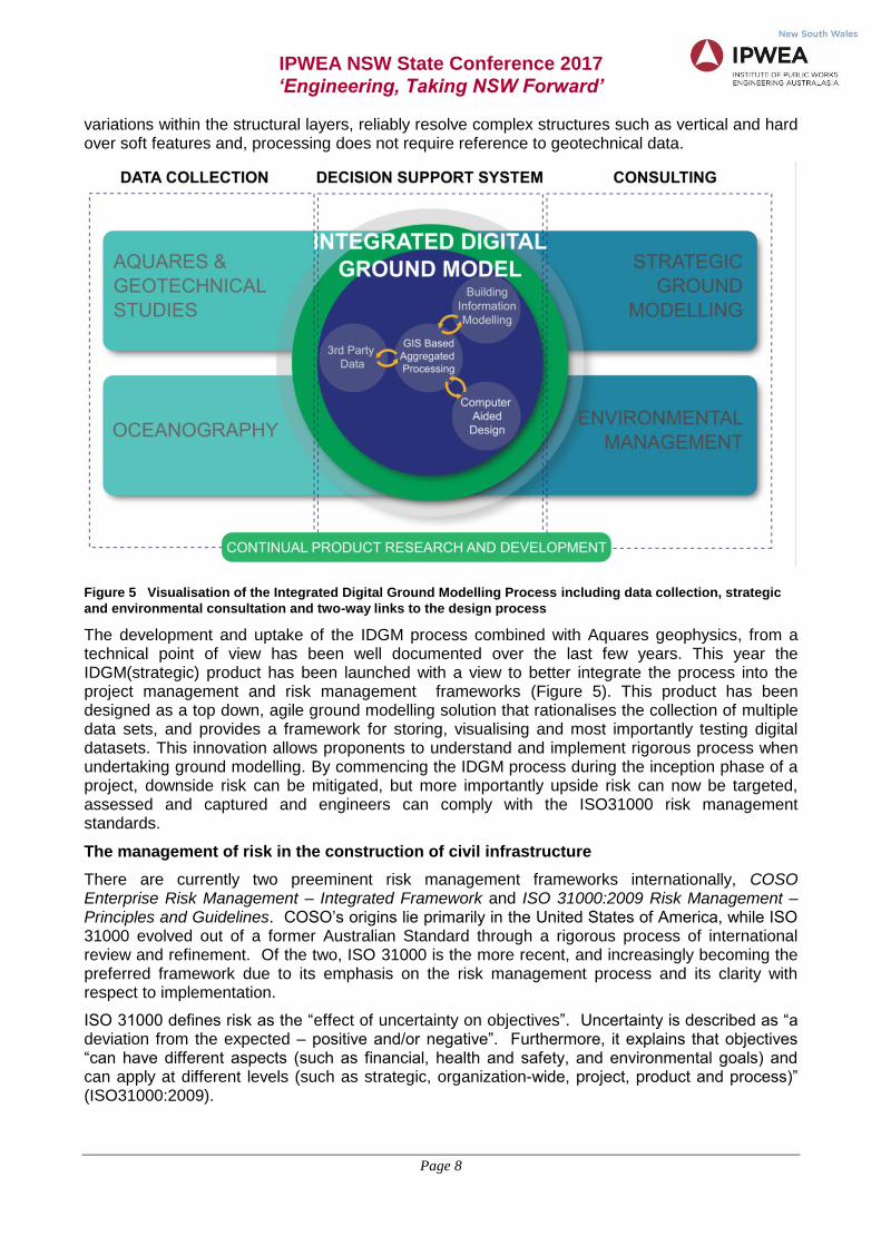
Figure 5 Visualisation of the Integrated Digital Ground Modelling Process including data collection, strategic
and environmental consultation and two-way links to the design process
The development and uptake of the IDGM process combined with Aquares geophysics, from a technical point of view has been well documented over the last few years. This year the IDGM(strategic) product has been launched with a view to better integrate the process into the project management and risk management frameworks (Figure 5). This product has been designed as a top down, agile ground modelling solution that rationalises the collection of multiple data sets, and provides a framework for storing, visualising and most importantly testing digital datasets. This innovation allows proponents to understand and implement rigorous process when undertaking ground modelling. By commencing the IDGM process during the inception phase of a project, downside risk can be mitigated, but more importantly upside risk can now be targeted, assessed and captured and engineers can comply with the ISO31000 risk management standards.
The management of risk in the construction of civil infrastructure
There are currently two preeminent risk management frameworks internationally, COSO Enterprise Risk Management – Integrated Framework and ISO 31000:2009 Risk Management – Principles and Guidelines. COSO’s origins lie primarily in the United States of America, while ISO 31000 evolved out of a former Australian Standard through a rigorous process of international review and refinement. Of the two, ISO 31000 is the more recent, and increasingly becoming the preferred framework due to its emphasis on the risk management process and its clarity with respect to implementation.
ISO 31000 defines risk as the “effect of uncertainty on objectives”. Uncertainty is described as “a deviation from the expected – positive and/or negative”. Furthermore, it explains that objectives “can have different aspects (such as financial, health and safety, and environmental goals) and can apply at different levels (such as strategic, organization-wide, project, product and process)” (ISO31000:2009).
IPWEA NSW State Conference 2017
‘Engineering, Taking NSW Forward’
Page 9
While financial institutions have long understood risk as being potentially positive and/or negative, from an engineering perspective, risk management grew out of attempts by engineers to avoid engineering failures, often as a result of high profile accidents in the aviation and nuclear industries. Terms such as Probabilistic Risk Analysis, which uses data about failures to calculate risks in a system, and Failure Modes and Effects Analysis were standard curriculum for engineering degrees in the later part of the twentieth century. This perspective, which can be summarised as ‘avoid failures’ is still, to a significant extent, embedded in the paradigms and planning processes within engineering professions.
The ISO 31000 definition of risk departs from this perspective in its insistence on considering upside risk or opportunities and it is intended to be applied to engineering risks as much as financial and operational risks. The expectation contained within ISO 31000 is that organisations should understand and manage uncertainty and where appropriate, mitigate downside risk and capitalise on upside risk in the pursuit of objectives. The ISO 31000 process for the management of risk includes:
Establishing the Context
Risk Assessment, which is further broken down into:
o Risk Identification
o Risk Analysis
o Risk Evaluation
Risk Treatment
Concurrent and iteratively with these steps are Communication and Consultation and, Monitoring and Review.
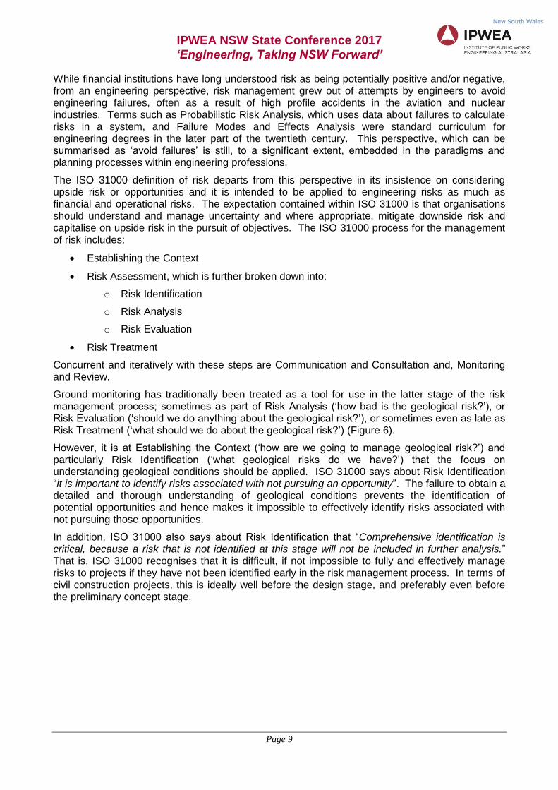
Ground monitoring has traditionally been treated as a tool for use in the latter stage of the risk management process; sometimes as part of Risk Analysis (‘how bad is the geological risk?’), or Risk Evaluation (‘should we do anything about the geological risk?’), or sometimes even as late as Risk Treatment (‘what should we do about the geological risk?’) (Figure 6).
However, it is at Establishing the Context (‘how are we going to manage geological risk?’) and particularly Risk Identification (‘what geological risks do we have?’) that the focus on understanding geological conditions should be applied. ISO 31000 says about Risk Identification “it is important to identify risks associated with not pursuing an opportunity”. The failure to obtain a detailed and thorough understanding of geological conditions prevents the identification of potential opportunities and hence makes it impossible to effectively identify risks associated with not pursuing those opportunities.
In addition, ISO 31000 also says about Risk Identification that “Comprehensive identification is critical, because a risk that is not identified at this stage will not be included in further analysis.” That is, ISO 31000 recognises that it is difficult, if not impossible to fully and effectively manage risks to projects if they have not been identified early in the risk management process. In terms of civil construction projects, this is ideally well before the design stage, and preferably even before the preliminary concept stage.
IPWEA NSW State Conference 2017
‘Engineering, Taking NSW Forward’
Page 10
Figure 6 A comparison of the value of opportunities associated with early and late stage ground modelling.
Currently ground modelling is typically done at or near the planning and execution stage minimising the upside
risk that can be evaluated and captured and the mitigation of downside risks
Governments are in the business of providing services to communities, and often this involves the public construction and ownership of infrastructure assets. However, what is often missed is a thorough and detailed risk based consideration of the optimal asset type and arrangement based on the external context in which the asset must exist. Geological conditions which are unable to be fully understood using boreholes may provide opportunities to reduce costs or may be better suited to alternative solutions than the one originally envisaged when attempting to find a way to meet community needs. This can only be rectified by understanding the underlying geology at either Establishing the Context or Risk Identification stage, and can only comprehensively be achieved through the use of continuous and highly detailed data sets. Boreholes, by their very nature, are neither continuous, nor detailed, and hence their use in isolation does not allow compliance with the requirements of ISO 31000.
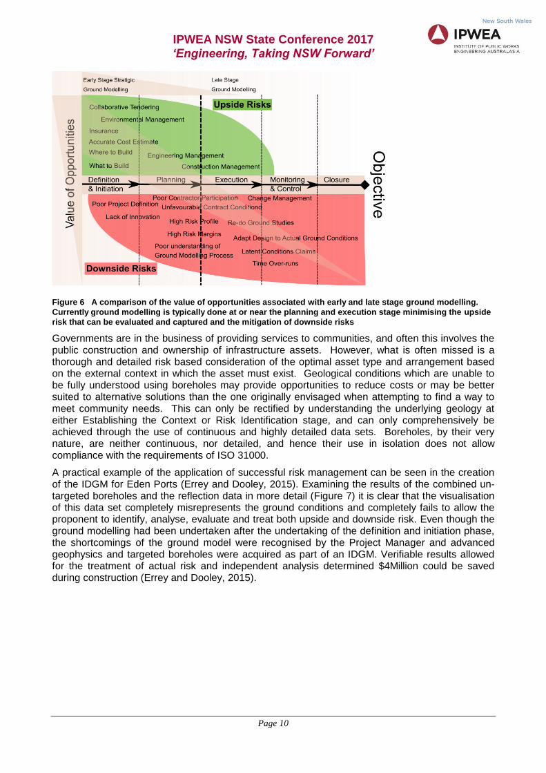
A practical example of the application of successful risk management can be seen in the creation of the IDGM for Eden Ports (Errey and Dooley, 2015). Examining the results of the combined un-targeted boreholes and the reflection data in more detail (Figure 7) it is clear that the visualisation of this data set completely misrepresents the ground conditions and completely fails to allow the proponent to identify, analyse, evaluate and treat both upside and downside risk. Even though the ground modelling had been undertaken after the undertaking of the definition and initiation phase, the shortcomings of the ground model were recognised by the Project Manager and advanced geophysics and targeted boreholes were acquired as part of an IDGM. Verifiable results allowed for the treatment of actual risk and independent analysis determined $4Million could be saved during construction (Errey and Dooley, 2015).
IPWEA NSW State Conference 2017
‘Engineering, Taking NSW Forward’
Page 11
Figure 7 The jetty alignment at Eden port. Here the combination of reflection geophysics and boreholes did not
make sense and failed to contribute to the understanding of what structures would suit the project objectives or
how they should be built
Application of the Integrated Digital Ground Model (strategic)
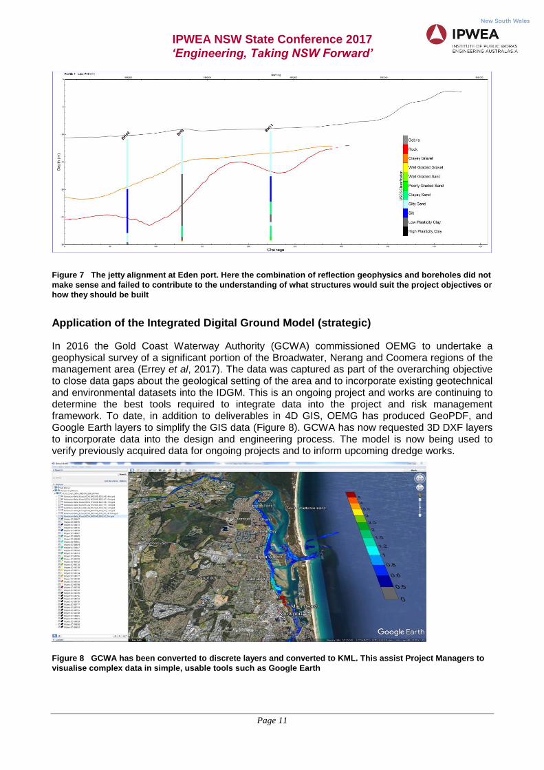
In 2016 the Gold Coast Waterway Authority (GCWA) commissioned OEMG to undertake a geophysical survey of a significant portion of the Broadwater, Nerang and Coomera regions of the management area (Errey et al, 2017). The data was captured as part of the overarching objective to close data gaps about the geological setting of the area and to incorporate existing geotechnical and environmental datasets into the IDGM. This is an ongoing project and works are continuing to determine the best tools required to integrate data into the project and risk management framework. To date, in addition to deliverables in 4D GIS, OEMG has produced GeoPDF, and Google Earth layers to simplify the GIS data (Figure 8). GCWA has now requested 3D DXF layers to incorporate data into the design and engineering process. The model is now being used to verify previously acquired data for ongoing projects and to inform upcoming dredge works.
Figure 8 GCWA has been converted to discrete layers and converted to KML. This assist Project Managers to
visualise complex data in simple, usable tools such as Google Earth
IPWEA NSW State Conference 2017
‘Engineering, Taking NSW Forward’
Page 12
Conclusions
In discussing the economics of bridge selection, Main Roads (2009 pp14) states “…the cost estimate is usually the principle means of selection between design options and construction methods”. The annunciation of a clear bias within procurement of design and construct to favour price over value undoubtedly extends to other aspects of the project management framework, such as ground modelling, environmental and social studies amongst others. It sends a clear message to the market that value and innovation based, non complying tenders will be set an artificially high bar during the analysis of those tenders. This is particularly relevant when the number and location of boreholes is prescribed; ground modelling is included as a component of a consultant’s project inception contract, and/or acceptable geophysical techniques are prescribed.
Foundations generally make up 10% to 30% of the overall cost of construction but result in up to 50% of projects running over cost or budget as a result of unforeseen conditions. These losses are directly attributed to incorrect conclusions that are drawn from inadequate ground studies. A robust study of the ground, undertaken during the inception phase of a project, will contribute significantly to project economics and risk management. Passing risk to a construction company will; result in a proponent paying a premium for downside risk, fail to return upside risk to the proponent, and result in smaller companies declining to bid as a result of risk perceptions. In general construction companies are not insurance companies and are risk adverse.
In the context of the modern understanding of risk management, ISO 31000 defines risk as “the effect of uncertainty on objectives”. In this risk management scenario, it is possible to have both upside and down side risks that will add or subtract value from a project respectively. The idea that ground modelling is simply a tool associated with design and construct must change as it does nothing to capture opportunity risk or mitigate early stage downside risk, such as lack of innovation or poor project definition. Upside risk particularly, is best understood and capitalised on by the proponent. A robust project management framework will allow for this to occur, however, a ground study that is designed to simply address engineering at or near the execution phase of a project will fail to capture upside risk and will not allow for the mitigation of downside risk Finally, the communication of risk is never about what the project manager believes it to be, rather it is about what the Project Manager can prove it to be. The Integrated Digital Ground Model underpinned by advanced Aquares geophysics has been proven to be a framework by which risk can be effectively communicated, resulting in significant project cost savings.
Disclaimer
The opinions expressed in this paper are the authors’ and do not necessarily represent the views of any local or state government entities.
References
Baynes, B.J. (2010). Sources of geotechnical risk, Quarterly Journal of Engineering Geology and Hydrogeology, 43, 321-331.
Errey, J.C. and Brabers, P.M. (2013). Using Geophysics as a Tool for Mitigating Project Risk, Coasts and Ports 2013: 21st Australasian Coastal and Ocean Engineering Conference and the 14th Australasian Port and Harbour Conference, Manly Australia, 10 - 13 September 2013
Errey, J.C. and Stewart-Rattray, R.J. (2015). Review of Sustainability Outcomes for Infrastructure Projects Gained Through the use of Modern Qualitative Geophysical Methods. IPWEA IFME joint International Conference. Rotorua N.Z. 8 – 10 June 2015
IPWEA NSW State Conference 2017
‘Engineering, Taking NSW Forward’
Page 13
Errey, J and Dooley, M (2015). Creating an Integrated Digital Ground Model for Eden Port. Australasian Coasts & Ports Conference 2015 15 - 18 September 2015, Auckland, New Zealand
Errey, J. Bourner, J. and McRae, B (2017). Developing a Strategic Ground Model for the Gold Coast Waterways. Coasts & Ports 2017 Conference – Cairns, 21-23 June 2017
Main Roads Western Australia, (2009). Structural Engineering Design Manual, Document number 3912/03/00 issue 22/06/09, The Government of Western Australia.
ISO, I. (2009). 31000: 2009 Risk management–Principles and guidelines. International Organization for Standardization, Geneva, Switzerland.
Author Biography
Jason Errey
Jason has over 15 years of experience in the Environmental and Oceanographic industry including extensive experience in managerial roles in Australia and the Middle East, and a Masters specialising in Marine Geology. His experience extends to consultation programs, ecological monitoring, coastal benthic studies, hydrographic surveys and geophysical surveys including extensive experience managing Aquares survey in land, marine and freshwater environments. Jason has the ability to understand pressing problems faced by clients and find solutions. He is the key innovator responsible for the development of OEMG’s award winning Integrated Digital Ground Model (IDGM).
Anton Juodvalkis has served as the Manager Governance and Engagement for Bellingen Shire Council since 2012 and is a member of the Nambucca Shire Council Audit, Risk and Improvement Committee and is on the board of ozGreen. He has a broad skill base ranging from corporate governance, risk and compliance through program and project management, change management, accounting, business analysis, procurement, asset management, and engineering. He has worked in a diverse range of industries including government, fast-moving consumer goods, telecommunications, print management, investment management, and manufacturing. Anton is passionate about what makes organisations successful, and is currently studying a Masters of Business Psychology. For fun, he likes to fight fires and explore the world.