Page 1
Journal of the Geological Society, London, Vol. 160, 2003, pp. 829–845. Printed in Great Britain.
829
The history of the major rivers of southern Britain during the Tertiary
P. L. GIBBARD 1 & J. LEWIN 2
1Godwin Institute of Quaternary Research, Department of Geography, University of Cambridge, Downing Street,
Cambridge CB2 3EN, UK (e-mail: [email protected] )2Institute of Geography and Earth Sciences, University of Wales, Aberystwyth SY23 2DB, UK
Abstract: The evolution of the drainage system of lowland Britain is discussed on the basis of available
geological evidence, including that from terrestrial sites and that which has more recently become available
from offshore exploration of the North Sea, the English and Bristol Channels, and the Irish Sea. Tertiary
stratigraphy throws considerable light on landform and river development. Paleocene destruction of a chalk
cover, which seems to have been incomplete in western Britain, was accompanied by basin sedimentation
under a tropical climate. The major elements, the Thames, Solent, Hampshire (?proto-Avon) river, Irish Sea
river and possibly an early Trent river, existed almost throughout the Cenozoic. The influence of Atlantic
rifting and thermal doming in NW Britain appears to have been stronger and more temporally focused than
the persistent flexuring that determined and maintained Tertiary drainage lines in the SE. Here also the folded
Mesozoic terrains on the surface contrast with the more dominant block-faulted relief of the Palaeozoic
‘oldlands’. The rivers of the SE can be shown to have extended or reduced their lengths in response to relative
sea-level change and gentle warping. Drainage antecedence, the destruction of the Solent system and the
breaching of the English Channel are also evident. By contrast, the major river systems of the west are now
entirely submerged. Long-term stability of the drainage pattern reflects a persistent tectonic regime in the
south, with a subdued low-relief landscape having a weathered regolith and dense vegetation cover.
Meandering river channels and alluvial styles predominated, although channel forms varied according to
sediment load, slope and discharge variability. Coarse gravel-dominated accumulations are rare and localized.
Chemically stable lithologies dominate the clastic component throughout. It is apparent that the deeply incised
river valleys seen today are related to high, predominantly coarse sediment yields, encouraged by substantial,
rapid climate changes in the Pleistocene. This emphasizes the significance of mechanical compared with
chemical weathering for the rate and nature of landscape dissection, and the modifications that have arisen as
a result of glaciation, frost-climate weathering, rapidly changing climates and sea levels. The stratigraphical
evidence here reviewed is at variance with older, largely geomorphologically based landform evolution models
(‘denudational chronology’), but gives considerable support to the recent proposals emphasizing the
significance of Paleocene erosion, and enduring low-relief landscapes and drainage systems evolving alongside
fold development during the Paleogene. Given the depobasin evidence now available, postulated fluvially
active episodes can, and must, be linked to contemporaneous deposition. Some at least of the many
controversies involving the identity of erosion surfaces, the dating of them using only residual deposits and
weathering mantles, and the selection of particular Tertiary episodes as ones of landscape development can
now be resolved.
Keywords: Tertiary, rivers, stream sediments, drainage, landscapes.
Long-term drainage and landscape evolution have been important
research foci for over a century. In southern Britain, investigations
have centred on drainage evolution and its contribution to a
‘denudational chronology’ geomorphological school, which
reached its acme with the publication of Wooldridge & Linton’s
work Structure, Surface and Drainage in South-east England
(Wooldridge & Linton 1939, 1955). Despite some criticisms
(Pinchemel 1954) the conclusions reached therein reigned largely
supreme until the 1970s when a new generation of researchers
began questioning the conclusions on the basis of new evidence
becoming available from increasingly sophisticated investigation
of tectonic history (e.g. Ziegler 1987, 1994), sedimentology (e.g.
Plint 1983a) and pedology (e.g. Catt 1983; Green 1985). The
results continue to provoke reassessments of the geomorphology
of southern England (Jones 1980, 1981, 1999a,b) and beyond (e.g.
Walsh et al. 1987, 1996; Walsh 1999; Mignon & Goudie 2001).
The approaches of Wooldridge & Linton (1939, 1955) and
their immediate followers were essentially underpinned by three
concepts.
(1) Geomorphology could use deduction and inference to erect
a history of landform development using evidence from land-
forms themselves to fill an apparent gap in Earth history after
the rock record ceased. Only later on did the focus shift to a
detailed reconstruction of processes and the stratigraphy of
‘superficial’ deposits.
(2) The Davisian cycle of erosion was the persuasive theor-
etical basis available for interpretation. In this, uplift was
followed by progressive erosion and stream adjustment to
geological ‘structure’ (including lithological outcrop) as relief
reduced to an eventual peneplain (summarized by Davis 1909).
(3) Sea levels changed; this could include progressively falling
base levels, and might involve marine onlap and offlap at
particular periods. Ideas concerning superimposition from a
chalk cover and the development of marine shorelines came to
Britain from the work of Johnson (1919, 1931).
Thus the evidence that Wooldridge & Linton and their
followers made use of was primarily geomorphological. This
included accordance of hill summits to identify former marine
Page 2
surfaces or peneplains, relationships between stream courses and
structural elements to distinguish between surface types and to
reconstruct drainage evolution over time, and field mapping of
planation surfaces and related features. In the three decades
following initial publication of Wooldridge & Linton’s model,
there followed a whole series of regional studies focusing on
individual drainage basins or escarpment–backslope blocks and,
generally speaking, upon episodic incision with a falling base
level and on planation under hypothesized marine and fluvial
conditions (e.g. Sparks 1949; Clayton 1953; Yates 1956; Everard
1957; Johnson & Rice 1961; Kidson 1962; Brunsden 1963). A
similar effort was made to map and interpret surfaces in upland
areas of western Britain, with recognition of marine or subaerial
surfaces at higher levels (e.g. Hollingworth 1938; Balchin 1952;
Jones 1952; Brown 1960a,b; George 1961), although with
conflicting interpretations in the absence of related deposits.
Later research was able to involve a greater concentration on,
and technical knowledge of, residual deposits and weathering
products associated with particular surfaces (Clark et al. 1967;
Summerfield & Goudie 1980; Catt 1983; Green 1985; Moffat &
Catt 1986; Ulyott et al. 1998). In general, these studies have
thrown considerable doubt on the earlier Wooldridge & Linton
model, as weathering products, like the widespread Clay-with-
flints on the Chalk, have not proved to be what they initially
seemed. Further north and west, residual deposits and Tertiary
outliers have been carefully examined. Again, conclusions from
such studies conflict with earlier assumptions (Battiau-Queney
1984; Walsh et al. 1987, 1996; Walsh 1999). Finally, detailed
mapping of surfaces and the interpretation of drainage patterns
has suggested some convincing alternatives to the Wooldridge &
Linton model (see Pinchemel 1954; Small 1964, 1980; Jones
1980, 1983, 1999a).
Given also the new mobile tectonic framework made available
through developments in plate tectonics, and new information
derived from exploration of the shelf sea floor, evidence has been
growing that the erosional landscape has inherited substantial
elements from throughout the Cenozoic beginning in the Paleo-
cene and incorporating earlier elements in the west (George
1974; Chadwick 1993; Jones 1999a). Thus any study of the
evolution of the major drainage elements of the southern British
Isles must begin at the latest with the Paleogene or even earlier
in the Palaeozoic ‘oldlands’ where a Chalk cover may not have
been complete (see George (1974) and Walsh (1999) for discus-
sions).
Furthermore, although the recent concentration on residuals
and surfaces is fully understandable, it appears timely to
reconsider the evidence provided by larger known bodies of
Tertiary sediment. Erosion and depositional systems are necessa-
rily linked, with the latter able to provide key information on the
timing, environment and extent of the former. It appears that
whereas the basal unconformities of Tertiary formations and
epochs have been projected to indicate erosion levels (e.g. the
variously termed sub-Eocene, early Tertiary, sub-Paleocene, sub-
Oligocene surfaces recently incorporated into polygenetic models
by Jones (1999a)), the diagnostic potential provided by the major
bodies of Tertiary sediments has not been adequately developed.
There is now sufficient evidence to assess river development
from the standpoint of fluvial sedimentology and provenance,
rather than surface morphology alone. Based on the location of
deposits and their provenance, it is possible to indicate broad
drainage lines (commonly called ‘proto-’ river systems), although
not with very great detail. In some instances, sediments allow
former channel types and depositional styles to be suggested, and
they may also be indicative of erosional energy and weathering
regime in the catchments that supplied them. A similar approach
was successfully adopted for a synthesis of NW European
drainage history of the last 3 Ma by Gibbard (1988). The same
approach is applied here, with the effects of supplementing or
modifying earlier conclusions drawn largely from erosion sur-
faces and residual deposits.
Tectonic and structural background
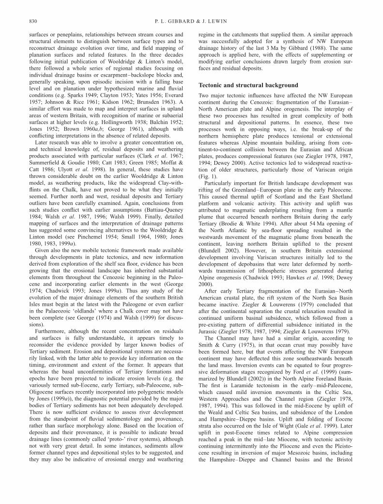
Two major tectonic influences have affected the NW European
continent during the Cenozoic: fragmentation of the Eurasian–
North American plate and Alpine orogenesis. The interplay of
these two processes has resulted in great complexity of both
structural and depositional patterns. In essence, these two
processes work in opposing ways, i.e. the break-up of the
northern hemisphere plate produces tensional or extensional
features whereas Alpine mountain building, arising from con-
tinent-to-continent collision between the Eurasian and African
plates, produces compressional features (see Ziegler 1978, 1987,
1994; Dewey 2000). Active tectonics led to widespread reactiva-
tion of older structures, particularly those of Variscan origin
(Fig. 1).
Particularly important for British landscape development was
rifting of the Greenland–European plate in the early Paleocene.
This caused thermal uplift of Scotland and the East Shetland
platform and volcanic activity. This activity and uplift was
attributed to magmatic underplating resulting from a mantle
plume that occurred beneath northern Britain during the early
Tertiary (Brodie & White 1994). After about 54 Ma opening of
the North Atlantic by sea-floor spreading resulted in the
westwards movement of the magmatic plume from beneath the
continent, leaving northern Britain uplifted to the present
(Blundell 2002). However, in southern Britain extensional
development involving Variscan structures initially led to the
development of depobasins that were later deformed by north-
wards transmission of lithospheric stresses generated during
Alpine orogenesis (Chadwick 1993; Hawkes et al. 1998; Dewey
2000).
After early Tertiary fragmentation of the Eurasian–North
American crustal plate, the rift system of the North Sea Basin
became inactive. Ziegler & Louwerens (1979) concluded that
after the continental separation the crustal relaxation resulted in
continued uniform basinal subsidence, which followed from a
pre-existing pattern of differential subsidence initiated in the
Jurassic (Ziegler 1978, 1987, 1994; Ziegler & Louwerens 1979).
The Channel may have had a similar origin, according to
Smith & Curry (1975), in that ocean crust may possibly have
been formed here, but that events affecting the NW European
continent may have deflected this zone southeastwards beneath
the land mass. Inversion events can be equated to four progres-
sive deformation stages recognized by Ford et al. (1999) (sum-
marized by Blundell (2002)) in the North Alpine Foreland Basin.
The first is Laramide tectonism in the early–mid-Paleocene,
which caused mild inversion movements in the Celtic Sea,
Western Approaches and the Channel region (Ziegler 1978,
1987, 1994). This was followed in the mid-Eocene by uplift of
the Weald and Celtic Sea basins, and subsidence of the London
and Hampshire–Dieppe basins. Uplift and folding of Eocene
strata also occurred on the Isle of Wight (Gale et al. 1999). Later
uplift in post-Eocene times related to Alpine compression
reached a peak in the mid–late Miocene, with tectonic activity
continuing intermittently into the Pliocene and even the Pleisto-
cene resulting in inversion of major Mesozoic basins, including
the Hampshire–Dieppe and Channel basins and the Bristol
P. L. GIBBARD & J. LEWIN830
Page 3
Channel and Western Approaches Trough, and updoming of the
Pays de Bray Anticline in the Paris Basin and the Weald–Artois
Anticline (Ziegler 1978, 1987, 1994; Blundell 2002). Uplift of
basement block massifs, particularly aligned along the western
and northern part of the region, also occurred during these
phases. This was accompanied by rapid subsidence of local pull-
apart basins during the Oligocene, such as the Lough Neagh
Basin in Northern Ireland, the Cardigan Bay Basin and in Devon
(Lake & Karner 1987), which occurred as a consequence of
short-lived wrench faulting along the NW–SE-aligned Stickle-
path–Lustleigh system. Blundell (2002) considered that the post-
Miocene uplift of southern Britain cannot be attributed to basin
inversion but more probably resulted from compensatory isostatic
rebound following denudational offloading, possibly accompa-
nied by strain release. However, according to Japsen & Chalmers
(2000), uplift during the Neogene fits a pattern of late Cenozoic
intraplate uplift that is known from around the North Atlantic.
The loss of Mesozoic rocks that once covered large areas of
western and northern Britain has been the subject of extended
discussion. The pulsed uplift resulting from periodic magma
injection, noted above, resulted in surface rejuvenation, produ-
cing substantial siliclastic deposition in the North Sea between
54 and 62 Ma, as described by White & Lowell (1997). These
workers’ fission-track and vitrinite reflectance data have been
confirmed by Green (1986, 1989), Lewis et al. (1992) and
Rowley & White (1998), who concluded that denudation of the
eastern Irish Sea Basin resulted in between 1.5 and 3 km of
exhumation with attendant removal of surface rock cover in the
early Tertiary. Moreover, fission-track studies have shown evi-
dence for a mid-Cenozoic cooling event that began c. 30 Ma that
may have caused a further 1 km of denudation along the NW
European continental margin resulting from changes in mantle
heat flow (Rohrman et al. 1995; Japsen et al. 2002; Cunningham
et al. 2003). This relief creation and erosional activity was much
more pronounced in the north than further south and later in the
Tertiary (see Bowman 1998; Blundell 2002), which reflects the
position of the magmatic plume and its movement west as the
North Atlantic opened. This process has been invoked to explain
the early Tertiary history of Britain by Cope (1994), for example
(but see also George 1974). Cope suggested that uplift centred
on NW Britain may explain the southeastwards tilt of the
English–Welsh block, attributed to a Cretaceous-aged hotspot
centred on the Irish Sea. Such a hotspot would have led to the
injection of igneous material below the surface causing dome-
like uplift of an area 500 km in diameter. The resulting updomed
area has been particularly deeply eroded but its effect is thought
by Cope (1994, 1995) to explain the alignment of the modern
lowland British drainage pattern, albeit modified by Pleistocene
glaciation, although this is not universally accepted (Thomson
1995).
By far the largest Cenozoic basin is the NW European Basin,
which extends from Poland to the northern North Sea. This basin
had become stabilized by the Miocene and subsequently subsided
in an irregular manner (Ziegler 1978, 1994; Japsen et al. 2002).
This, together with the North Sea Basin, received huge volumes
of sediment during the Cenozoic, particularly during the Paleo-
gene. This basin is estimated to contain up to 3500 m of
sediment for the whole period (Ziegler 1978) compared with a
thickness of over 1000 m from the Quaternary alone.
Palaeogeographical setting
At the beginning of the Paleogene Britain stood at latitude 408N,
128S of its position today (Irving 1967; Daley 1999). The Earth’s
climate, which had been extremely warm during the Cretaceous
‘hot-house’, continued to be both warm and without the extreme
fluctuations of the later Quaternary (Wolfe 1978). An overall,
long-term trend of cooling climates through the Tertiary is first
seen in changing floral assemblages from late in the early Eocene
(Collinson et al. 1981; Daley 1999; Collinson & Cleal 2001a)
Fig. 1. Tectonic map of the British region
in the early Paleogene (modified after
Ziegler 1987, 1994).
TERTIARY RIVERS OF SOUTHERN BRITAIN 831
Page 4
culminating in the warm-temperate climate of the late Neogene
(Zagwijn & Hager 1987; Zagwijn 1992).
Immediately before the Paleogene, the British region was
submerged beneath the shallow Late Cretaceous Chalk sea. Some
areas probably remained emergent, as in Wales, Scotland and
Fennoscandia, but were of low relief. Emergence became more
general by the Maastrichtian (Late Cretaceous), and by the
Danian (Early Paleocene) was widespread (Murray 1992). This
change was accompanied by a replacement of the longstanding
deposition of marine carbonates by clastic sediments (Curry et
al. 1978). This is attributed to increased erosion of both the
emergent and submergent regions consequent on the widespread
uplift associated with the opening of the North Atlantic region in
late Paleocene times (Boulter & Kvacek 1989), mentioned above.
Compared with this Late Cretaceous–Early Tertiary uplift and
erosion, later Oligocene and Miocene events appear to have been
relatively mild (Lewis et al. 1992), regionally restricted (Green
et al. 2001) and related to basin compression and inversion
(Chadwick 1993; Hawkes et al. 1998; Dewey 2000; Blundell
2002).
From the beginning of the Tertiary, Britain was surrounded by
depositional basins. To the west the Atlantic Ocean–Greenland
Sea basin began to open, with its periodic connections to the
Channel, Paris and Western Approaches basins in the south
(Pomerol 1973; Kent 1975; Thiry & Dupois 1998; Daley 1999).
The long-established North Sea Basin, already referred to, lay to
the east. Finally, the extension of the northern North Sea Basin
to the east was the west–east-oriented NW European Basin that
extended into modern Poland (Ziegler 1978, 1987). This basin
also formed a major depositional feature throughout the Tertiary
and early Pleistocene (Gibbard 1988).
The Tertiary deposits of lowland Britain, particularly those of
the Paleogene in the main depositional Hampshire–Dieppe and
London basins, characteristically record alternating transgression
and regression sequences that have been attributed to global
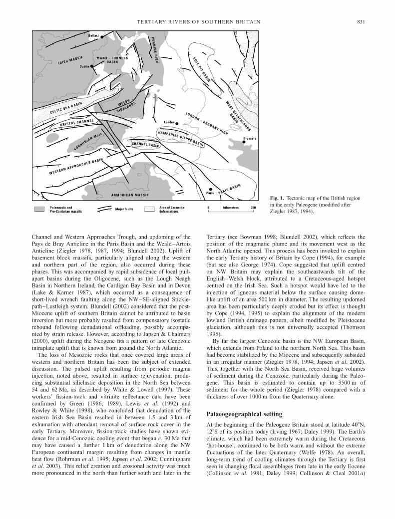
eustatic sea-level cycles (Plint 1983b, 1988; Haq et al. 1987;
Neal 1996; Fig. 2). Pulsed tectonism has also been invoked
(Knox 1996). Although initially restricted to the eastern end of
the London Basin, later transgressions became more extensive,
some reaching the Hampshire–Dieppe Basin. Over 20 such
transgressions have so far been identified (Daley 1999, fig. 2.6).
The older Eocene strata (London Clay, Bracklesham Group,
Barton Group) represent major transgressive periods, involving
several individual transgressive events. By contrast, few are
found in the non-marine Solent Group of the Hampshire region
(Daley 1999). Overall the sea level through the Cenozoic
parallels the level of global temperature (Miller et al. 1987),
showing a long-term downward trend that culminates in the
glacioeustatic lowstands that typify the Quaternary (Fig. 2). The
sea-level record represented in the British sequences reflects the
interplay of the long-term trend with substantial eustatically
driven oscillations, themselves modified by local tectonic activ-
ity. Attempts to relate the local sea-level record to global curves
(e.g. Plint 1988) are hindered by the need to untangle these
interacting drives.
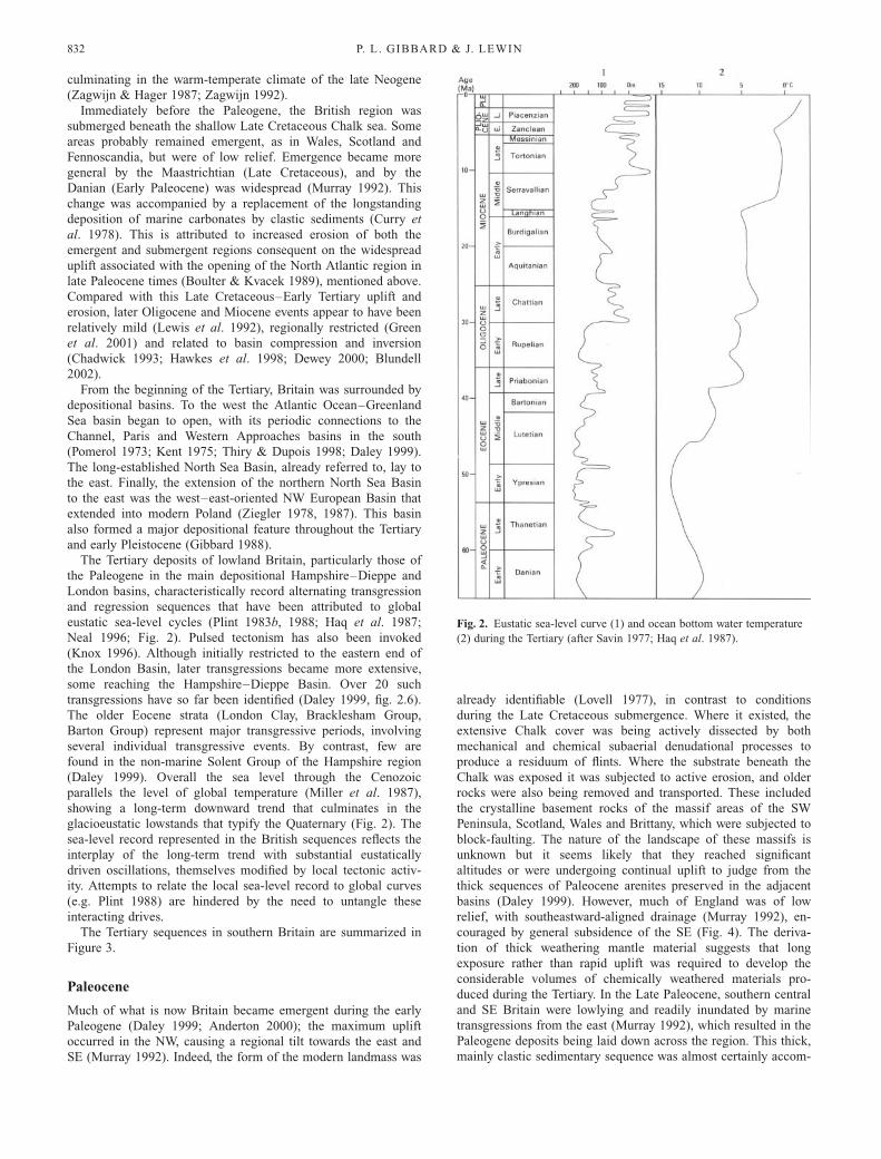
The Tertiary sequences in southern Britain are summarized in
Figure 3.
Paleocene
Much of what is now Britain became emergent during the early
Paleogene (Daley 1999; Anderton 2000); the maximum uplift
occurred in the NW, causing a regional tilt towards the east and
SE (Murray 1992). Indeed, the form of the modern landmass was
already identifiable (Lovell 1977), in contrast to conditions
during the Late Cretaceous submergence. Where it existed, the
extensive Chalk cover was being actively dissected by both
mechanical and chemical subaerial denudational processes to
produce a residuum of flints. Where the substrate beneath the
Chalk was exposed it was subjected to active erosion, and older
rocks were also being removed and transported. These included
the crystalline basement rocks of the massif areas of the SW
Peninsula, Scotland, Wales and Brittany, which were subjected to
block-faulting. The nature of the landscape of these massifs is
unknown but it seems likely that they reached significant
altitudes or were undergoing continual uplift to judge from the
thick sequences of Paleocene arenites preserved in the adjacent
basins (Daley 1999). However, much of England was of low
relief, with southeastward-aligned drainage (Murray 1992), en-
couraged by general subsidence of the SE (Fig. 4). The deriva-
tion of thick weathering mantle material suggests that long
exposure rather than rapid uplift was required to develop the
considerable volumes of chemically weathered materials pro-
duced during the Tertiary. In the Late Paleocene, southern central
and SE Britain were lowlying and readily inundated by marine
transgressions from the east (Murray 1992), which resulted in the
Paleogene deposits being laid down across the region. This thick,
mainly clastic sedimentary sequence was almost certainly accom-
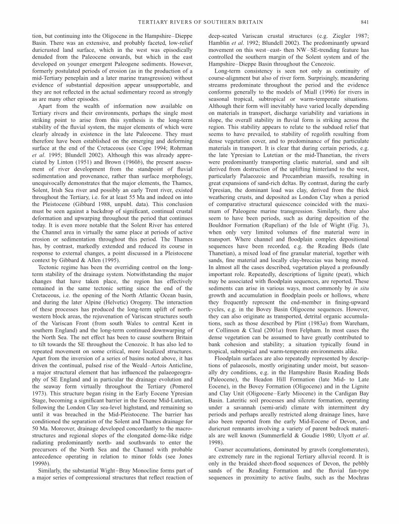
Fig. 2. Eustatic sea-level curve (1) and ocean bottom water temperature
(2) during the Tertiary (after Savin 1977; Haq et al. 1987).
P. L. GIBBARD & J. LEWIN832
Page 5
panied by marked subsidence for millions of years (Pomerol
1973).
The earliest Tertiary deposit in Britain is the marine Thanet
Sand Formation (Thanetian), a series of slightly glauconitic sands
that rest directly on the eroded transgressive surface on Chalk,
restricted to the eastern part of the London Basin but with
equivalents in Belgium and the Paris Basin (Fig. 3). This
formation is overlain by the Lambeth Group, which includes the
Woolwich Formation, a series of laguno-marine sediments that
pass westwards into the Reading Formation. The latter are a
series of clays and associated sediments of fluvial origin that
accumulated in a deltaic complex (Wells & Kirkaldy 1966;
Anderton 2000).
At least one major river, sometimes referred to as the ‘Eocene
Mississippi’ or ‘Amazon’ (e.g. Wooldridge & Gill 1925;
Wooldridge & Ewing 1935; Wells & Kirkaldy 1966) but more
realistically a proto-Thames system, entered the London Basin in
the area of the modern Chilterns from Hertfordshire, Middlesex,
Buckinghamshire and Berkshire. Here cross-stratified gravels and
sands, accompanied by silty clay lenticular channel fills asso-
ciated with inwashed plant material and frequent clay-clast
breccias, occur (e.g. Crane & Golding 1991). Such breccias
could have originated from bank undercutting during channel
migration (Wells & Kirkaldy 1966). Exotic clast assemblages,
including quartz and lydites, the latter derived from rocks of
Early Cretaceous and Late Jurassic age of the NW (Wooldridge
& Gill 1925; Wooldridge & Ewing 1935), are also found. They
are associated with mottled clays representing weathered, low-
energy floodplain accretionary sediments and locally with lignite
units up to 1 m thick (Hester 1965). Smaller tributaries may also
have contributed to the delta complex from the north, west and
even possibly the SW. These predominantly fining-upward type
sequences clearly indicate the occurrence in Reading times (late
Thanetian, c. 55 Ma ago) of at least one substantial, probably
actively meandering proto-Thames river from the NW (Hester
1965), possibly rejuvenated by contemporary earth movements.
This was transporting pebbly sand to clay-sized material and
forming a major delta complex (Fig. 4).
Reading facies-type sediments also occur in the Hampshire–
Dieppe Basin (Fig. 3). Here they comprise thin transgressive
pebbly sands, resting on Chalk, overlain by sands and mottled
clays (Hester 1965; Anderton 2000), deposited by rivers from the
west and SW. This is, in principle, the first evidence of a proto-
Solent River system. Heavy-mineral analysis of the sands clearly
indicates a possible Armorican contribution at this time (Morton
1982) but according to Daley (1972) they are unlikely to be of
fluvial origin because ‘the latter was periodically separated from
Britain’. Deposited during regression of the sea, the Reading
Formation of the Isle of Wight, the central Channel and mainland
localities such as Felpham (Bone 1986; Collinson & Cleal,
2001a) predominantly comprises mottled multicoloured clays;
the coloration is thought to result from subaerial weathering
(Buurman 1975, 1980; Daley 1999). Although these sediments
may in places be of lagoonal origin (Ellison 1983), it is generally
Fig. 3. Summary of the main Tertiary sequences in lowland Britain, showing the major lithostratigraphical units (modified from Daley & Balson 1999).
TERTIARY RIVERS OF SOUTHERN BRITAIN 833
Page 6
more likely that they represent floodplain vertical accretion
complexes that have been periodically affected by pedogenesis to
produce hydromorphic gley soils of fluvial to fluviomarine
origin. These soils formed under a warm climate with a distinct
rainy season (Buurman 1975, 1980). Associated channel-fill
sandy clay breccia and lignite are known from Sussex and the
Central Channel. At the former a diverse flora, including trees in
growth position, indicates a dense floodplain swamp forest of
warm, seasonally humid climate, comparable with those of the
modern southeastern USA (Collinson, in Bone 1986; Collinson
& Cleal 2001a). Further west at Studland Bay, the Reading
Formation comprises fluvial channel-fill current-bedded granular
sands containing fragmentary plant material (Daley 1999).
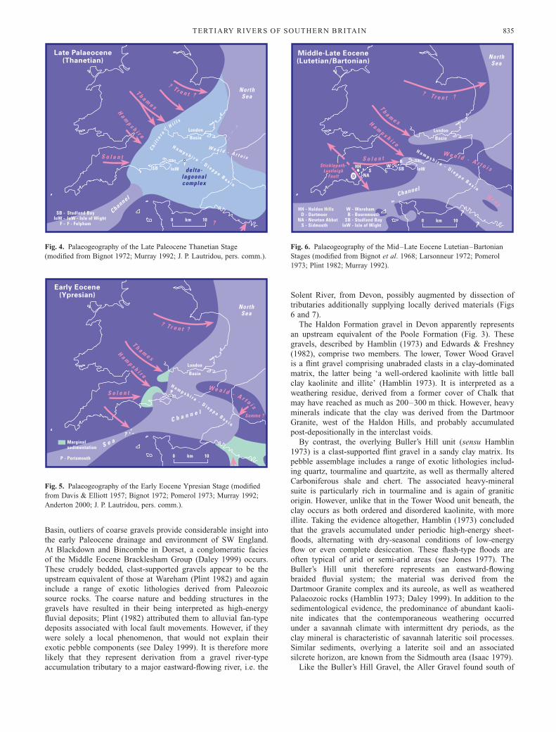
It therefore appears that the Thanetian was the first period
when substantial evidence of significant fluvial activity is
represented in both the Hampshire–Dieppe and London basins
(Fig. 4). Palaeocurrents and provenance indicators suggest
drainage alignment towards the SE. In both regions the rivers
seem to have adopted flow channels dominated by sands with
clay-plug type abandoned channel fills and notably clay-clast
breccias in the London region. The multicoloured mottled clays,
pedologically modified and associated lignitic units, and sedi-
mentation typically found in vertically accreted floodplain
sequences, are associated with fining-upward channel fills and
point-bar accumulations. The clay-clast breccias typify mean-
dering river sediments in tropical regions (Miall 1996). Here
rivers have cohesive banks, densely vegetated floodplains, and
predominantly transport fine material but also coarser sediment
during floods. Both the proto-rivers Solent and Thames and
others were already present at this time. Their preservation and
disposition, in the uppermost parts of the sequence, indicate that
they may have been extending their courses seaward to follow
the regressing sea.
Eocene
Early Eocene
The Eocene opens with renewed significant marine transgression
from the east resulting in deposition of Thames Group sediments,
the thickest and most extensive of which is the London Clay
Formation (Fig. 3), deposited during the Early Eocene Ypresian
Stage (Daley 1999; Anderton 2000). During this period, submer-
gence was most extensive towards the west and linked the
London and Hampshire–Dieppe basins (Fig. 5) (Davis & Elliott
1957; King 1981). At least five transgression–regression cycles
are represented, reflecting periods of sea-level rise followed by
shallowing and coastline progradation (Plint 1988; Anderton
2000). Thin, marginal sand and silt-dominated sediments are rare
in the London Basin but are found in the Hampshire–Dieppe
Basin in Dorset and western Hampshire, where they were
subjected to pedogenesis.
During deposition of the London Clay, the regional climate
was very warm, the surrounding land to the north, west and
south supporting dense tropical to subtropical and warm-tempe-
rate forests, with mangrove swamps on the coasts (Reid &
Chandler 1933; Anderton 2000; Collinson & Cleal 2001b).
Inland an ‘upland flora’ may have flourished, but temperate
elements were also well represented in the shallow marine
sediments (Daley 1972). The overall character of the flora shows
affinities with the present-day Malay Pensinsula, characterized by
high levels of precipitation and environmental stability (Daley
1972).
The nature of the land surface during London Clay times is
poorly known but appears to have continued to be subdued with
wide plains and no mountains in Wales (e.g. Wells & Kirkaldy
1966; Daley 1972). The major erosion phases seen earlier had
ceased and instead had given way to overall slow degradation of
exposed surfaces subjected to intense chemical weathering. This
is seen in the vast volumes of clay, which may have been
produced by extended earlier weathering and supplied to the
basinal areas by the rivers from the north and west. Only limited
evidence of actual channel systems is known at present. How-
ever, continual influx of river water has been invoked to explain
the low-diversity foraminiferal assemblage in the Hampshire–
Dieppe Basin by Murray & Wright (1974). In addition, incised
fluvial channels, formed during local sea-level lowstands and
then infilled by estuarine deposits during subsequent marine
transgression, are recorded from the Portsmouth and Whitecliff
members across the basin (Plint 1988). Davis & Elliot (1957)
recognized that the basal pebble beds of the Hampshire basin
region were derived from the SW, presumably by rivers (Fig. 5).
Those workers envisaged several smaller streams flowing north-
wards.
Late Early–early Mid-Eocene
London Clay deposition was brought to an end by a rapid
expansion of fluvial delta complexes towards the east in the late
Ypresian–Lutetian (early Mid-Eocene) (Fig. 6). In the London
Basin this transition is signalled by the sand–silt alternations of
the Claygate Beds and the subsequent accumulation of the
overlying Virginia Water–Bagshot Formation sands (Fig. 3). The
latter are marine in the east, but to the west represent a vast delta
complex (Wells & Kirkaldy 1966; Anderton 2000). The sedi-
ments are similar to the Reading deposits, consisting of cross-
bedded sands, with thin clay or silt partings and thin pebble beds,
becoming considerably coarser towards their western limit. This
transition from the London Clay to the overlying sands may
reflect either depression of the basin, or uplift of the hinterland
further west and NW, which encouraged river incision and
potentially increased discharges of coarser terrigenous sediments.
No later Paleogene fluvial or estuarine sediments are found in
the London Basin.
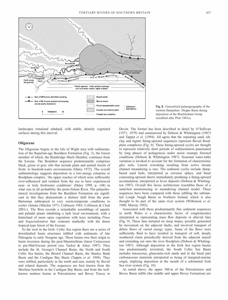
In the Hampshire–Dieppe Basin the London Clay is succeeded
by the Bracklesham Group sequences (Fig. 3); in particular by
the coarse cross-bedded fluvial sands of the Poole Formation in
the western part of the basin, e.g. around Wareham, that span the
latest Ypresian (or ‘Cuisian’) to mid-Lutetian stages (see Curry
et al. 1977). These sands pass laterally eastwards into silts and
fine sands of estuarine and marine origin. The basal sands, such
as those exposed at Studland Bay, Dorset, together with those of
the Bournemouth cliffs, Wareham and the Isle of Wight,
characteristically occur in fining-upward cycles that pass upwards
into lignitic sands and fine material rich in plant remains (Fig. 6;
Plint 1983a; Daley 1999). Plint (1983a) interpreted these se-
quences as representing actively meandering sand-bed rivers, but
with affinities to those of sandy braided streams. The progressive
westward coarsening of these deposits is accompanied by a
pebble composition that includes exotic clasts such as abundant
vein quartz, black chert, silicified limestone and siltstone, all
derived from Palaeozoic rocks but possibly reworked from the
Wealden (Plint 1982). The architecture of the sequences suggests
fluctuating, potentially seasonally varied discharge, and this
accords well with the predicted tropical to subtropical climate
(Smith et al. 1973) and a dense and diverse tropical to
subtropical vegetation (Daley 1972, 1999).
Further west, beyond the margins of the Hampshire–Dieppe
P. L. GIBBARD & J. LEWIN834
Page 7
Basin, outliers of coarse gravels provide considerable insight into
the early Paleocene drainage and environment of SW England.
At Blackdown and Bincombe in Dorset, a conglomeratic facies
of the Middle Eocene Bracklesham Group (Daley 1999) occurs.
These crudely bedded, clast-supported gravels appear to be the
upstream equivalent of those at Wareham (Plint 1982) and again
include a range of exotic lithologies derived from Paleozoic
source rocks. The coarse nature and bedding structures in the
gravels have resulted in their being interpreted as high-energy
fluvial deposits; Plint (1982) attributed them to alluvial fan-type
deposits associated with local fault movements. However, if they
were solely a local phenomenon, that would not explain their
exotic pebble components (see Daley 1999). It is therefore more
likely that they represent derivation from a gravel river-type
accumulation tributary to a major eastward-flowing river, i.e. the
Solent River, from Devon, possibly augmented by dissection of
tributaries additionally supplying locally derived materials (Figs
6 and 7).
The Haldon Formation gravel in Devon apparently represents
an upstream equivalent of the Poole Formation (Fig. 3). These
gravels, described by Hamblin (1973) and Edwards & Freshney
(1982), comprise two members. The lower, Tower Wood Gravel
is a flint gravel comprising unabraded clasts in a clay-dominated
matrix, the latter being ‘a well-ordered kaolinite with little ball
clay kaolinite and illite’ (Hamblin 1973). It is interpreted as a
weathering residue, derived from a former cover of Chalk that
may have reached as much as 200–300 m thick. However, heavy
minerals indicate that the clay was derived from the Dartmoor
Granite, west of the Haldon Hills, and probably accumulated
post-depositionally in the interclast voids.
By contrast, the overlying Buller’s Hill unit (sensu Hamblin
1973) is a clast-supported flint gravel in a sandy clay matrix. Its
pebble assemblage includes a range of exotic lithologies includ-
ing quartz, tourmaline and quartzite, as well as thermally altered
Carboniferous shale and chert. The associated heavy-mineral
suite is particularly rich in tourmaline and is again of granitic
origin. However, unlike that in the Tower Wood unit beneath, the
clay occurs as both ordered and disordered kaolinite, with more
illite. Taking the evidence altogether, Hamblin (1973) concluded
that the gravels accumulated under periodic high-energy sheet-
floods, alternating with dry-seasonal conditions of low-energy
flow or even complete desiccation. These flash-type floods are
often typical of arid or semi-arid areas (see Jones 1977). The
Buller’s Hill unit therefore represents an eastward-flowing
braided fluvial system; the material was derived from the
Dartmoor Granite complex and its aureole, as well as weathered
Palaeozoic rocks (Hamblin 1973; Daley 1999). In addition to the
sedimentological evidence, the predominance of abundant kaoli-
nite indicates that the contemporaneous weathering occurred
under a savannah climate with intermittent dry periods, as the
clay mineral is characteristic of savannah lateritic soil processes.
Similar sediments, overlying a laterite soil and an associated
silcrete horizon, are known from the Sidmouth area (Isaac 1979).
Like the Buller’s Hill Gravel, the Aller Gravel found south of
Fig. 6. Palaeogeography of the Mid–Late Eocene Lutetian–Bartonian
Stages (modified from Bignot et al. 1968; Larsonneur 1972; Pomerol
1973; Plint 1982; Murray 1992).
Fig. 4. Palaeogeography of the Late Paleocene Thanetian Stage
(modified from Bignot 1972; Murray 1992; J. P. Lautridou, pers. comm.).
Fig. 5. Palaeogeography of the Early Eocene Ypresian Stage (modified
from Davis & Elliott 1957; Bignot 1972; Pomerol 1973; Murray 1992;
Anderton 2000; J. P. Lautridou, pers. comm.).
TERTIARY RIVERS OF SOUTHERN BRITAIN 835
Page 8
Newton Abbott, Devon, provides additional evidence of early
Paleocene fluvial activity in SW England. This 25–30 m thick
sequence of cross-bedded and channelled flint gravels and sands,
the lenticular nature and horizontally bedding structure of the
matrix-supported gravel and sand, together with the large clast
size variability, frequent erosion surfaces, etc. all indicate deposi-
tion in a braided fluvial complex. The pebble assemblage again
confirms derivation from the SW, as it includes aureole as well
as rocks from the Dartmoor Granite itself, together with
unmetamorphosed Carboniferous rocks of north or northwestern
origin (Daley 1999).
Late Mid-Eocene–Late Eocene
In SW England a series of isolated, enclosed basins occur along
the line of the major NW–SE-trending Sticklepath–Lustleigh
wrench fault. They include the Bovey, Petrockstowe and the
minor Dutson Basin on land and the Stanley Bank Basin beneath
the Bristol Channel. The Bovey Basin is the largest of these
features, all of which are infilled by terrestrial, largely fluvial
sediments. The predominently argillaceous sediments of the
Bovey Formation are underlain by the Aller Gravel, discussed
above. Here, however, they are overlain by a complex, highly
variable sequence that is over 1000 m thick, described by
Edwards & Freshney (1982). The upper 300 m of these sedi-
ments are certainly of Oligocene age (see below) and are
exposed in quarries from which the koalinite-rich clay is
extracted. However, the lower 700 m thick unexposed part of the
sequence (the lower Bovey Formation) is of Eocene age and
represents accumulation in the fault-bounded trough during
which sedimentation kept pace with subsidence (Edwards 1976).
The sediments comprise silts, sand, gravel and, often lenticular,
silty clay, comparable with similar sediments in the Petrockstowe
basin, where the bulk of the deposits are Eocene (Edwards &
Freshney 1982). At Petrockstowe the basal sediments are again
braided stream gravels, derived from the Dartmoor Massif and
overlain by a series of upward-fining cyclic sequences of sands
to fine material, seatearths and deeply weathered palaeosols
(Edwards & Freshney 1982). These channel to floodplain
sediment cycles typify an active-meandering river, sands- to fine
material-dominated active- to stable-meandering or even in part
anastomosing system with stable floodplain surfaces, cut-off
meander channel fills, etc. However, the cyclicity is partly
attributed to subsidence. Here the sediments fine in a north-
westerly direction, indicating that the river was flowing into the
Stanley Bank Basin towards the Bristol Channel (Edwards &
Freshney 1982; Tappin et al. 1994), the latter appearing as a
landscape element for the first time at this stage. Comparable
sediments are also known from the St. George’s Channel Basin
beneath the Irish Sea (Tappin et al. 1994; see below). In contrast,
the Bovey Basin stream flowed to the SSE (Fig. 5), showing that
by this time the upper headwaters of the Solent River had been
severed by movement of the Sticklepath–Lustleigh Fault
(Edwards & Freshney 1982). A comparable deep infilled basin,
the Bassin de Rennes, occurs in Brittany.
The later Mid–Late Eocene (late Lutetian, Bartonian–Priabo-
nian) saw the continued sedimentation of freshwater and estuar-
ine sediments in the western part of the Hampshire–Dieppe
Basin. The extensive estuarine Boscombe Sand (Barton Forma-
tion) in the Hampshire–Dorset area (Fig. 3), reflects deposition
in a tidal channel environment that interfingers with beach
conglomerates (Plint 1983a, 1988). Fluvial deposits of Bartonian
age are apparently unknown but deposition of the Headon Hill
Formation (Solent Group) above occurred in near-coastal situa-
tions, including brackish lagoons, freshwater stream and shallow
alkaline lakes in a low-energy embayment (Fig. 8). The sedi-
ments include lacustrine freshwater limestones, silts, marls,
occasional sands and local lignite (Daley 1999; Anderton 2000).
In places, fossil variegated palaeosols, formed under conditions
of highly seasonal wetting and drying, also occur (Huggett et al.
2001). Although local stream input is represented, no large-scale
fluvial activity is apparently recorded.
The youngest Eocene sediment in the Hampshire–Dieppe
Basin is the Bembridge Limestone. This highly fossiliferous
muddy limestone complex represents deposition in a series of
pools and lakes with a limited local catchment surrounded by
dense forest (Collinson & Cleal 2001c) under a subtropical or
warm-temperate climate (Daley 1999). Although there is again
no direct evidence of substantial fluvial activity at the Isle of
Wight sites, it is highly probable that the Solent, and possibly a
Hampshire (?proto-Avon) river, continued to flow at some
distance, as sedimentation continued into the early Oligocene
Bembridge Marls (see below), which reflect deposition in a
sluggish-water estuary (Collinson 1983). The lack of fluvial
sediment implies either that discharges and/or sediment supply
were low, which reinforces the conclusion that southern English
Fig. 7. Hypothetical 3D sequence model
for point bars in the Mid-Eocene Poole
Formation of Dorset (after Plint 1983a).
P. L. GIBBARD & J. LEWIN836
Page 9
landscapes remained subdued, with stable, densely vegetated
surfaces during this interval.
Oligocene
The Oligocene begins in the Isle of Wight area with sedimenta-
tion of the Rupelian-age Bouldnor Formation (Fig. 3), the lowest
member of which, the Bembridge Marls Member, continues from
the Eocene. The Bouldnor sequence predominantly comprises
black, green or grey silts that include plant and animal fossils of
fresh- to brackish-water environments (Daley 1972). The overall
sedimentology suggests deposition in a low-energy estuarine or
floodplain complex, ‘the upper reaches of which were sufficiently
river-influenced and isolated from the sea to have experienced
near- or truly freshwater conditions’ (Daley 1999, p. 148) in
what was in all probability the proto-Solent River. The palaeobo-
tanical investigations from the Bouldnor Formation are signifi-
cant in that they demonstrate a distinct shift from the post-
Bartonian subtropical to very warm-temperate conditions to
cooler climate (Machin 1971; Collinson 1983; Collinson & Cleal
2001c). The flora records a remarkable assemblage of aquatic
and paludal plants inhabiting a lush local environment, with a
hinterland of more open vegetation with trees including Pinus
and Sequoiadendron that contrasts markedly with the dense
tropical-type forest of the Eocene.
To the west in the Irish–Celtic Sea region there are a series of
downfaulted basin structures infilled with sediments of late
Paleogene to early Neogene age. These basins owe their origin to
basin inversion during the post-Maastrichtian (latest Cretaceous)
to pre-Mid-Eocene period (see Tucker & Arker 1987). They
include the St. George’s Channel Basin, the North and South
Celtic Sea basins, the Bristol Channel Basin, the Stanley Bank
Basin and the Cardigan Bay Basin (Tappin et al. 1994). They
were infilled, particularly in the north and east, mainly by fluvial
and related deposits. The sequences are best known from the
Mochras borehole in the Cardigan Bay Basin, and from the well-
known onshore basins at Petrockstowe and Bovey Tracey in
Devon. The former has been described in detail by O’Sullivan
(1971, 1979) and summarized by Dobson & Whittington (1987)
and Tappin et al. (1994). All agree that the repeating sand, silt,
clay and lignite fining-upward sequences represent fluvial flood-
plain complexes (Fig. 9). These fining-upward cycles are thought
to represent relatively short periods of sedimentation punctuated
by long phases of pedogenesis under moist swampy forested
conditions (Dobson & Whittington 1987). Seasonal water-table
variation is invoked to account for the formation of characteristic
gley soils. Lateral reworking resulting from active stream
channel meandering is rare. The sediment cycles include sharp-
based sand beds, interpreted as crevasse splays, and basal
coarsening-upward sheets immediately predating a fining-upward
accumulation, interpreted as levee deposits (Dobson & Whitting-
ton 1987). Overall this facies architecture resembles those of a
sand-bed anastomosing or meandering channel model. These
sequences have been compared with those infilling the substan-
tial Lough Neagh Basin in Northern Ireland, which is also
thought to be part of the same river system (Wilkinson et al.
1980; Murray 1992).
Associated with these predominantly fine sediment sequences
in north Wales is a characteristic facies of conglomerates
interpreted as representing mass flow deposits or alluvial fans
(Fig. 9). These fans initiated on steep slopes, possibly generated
by movement on the adjacent faults, and involved transport of
debris flows of varied energy types. Some of the flows were
sufficiently fluid to have resulted in transport of soft, deeply
weathered clasts periodically derived from the adjacent massif
and extending out onto the river floodplain (Dobson & Whitting-
ton 1987). Although deposition in the Irish Sea region basins
was predominantly terrestrial, the South Celtic Sea Basin
includes micaceous, glauconite-rich sands and in the basal part
carbonaceous materials interpreted as being of marginal-marine
origin, implying deposition at the mouth of a substantial Irish
Sea river system (Fig. 10).
As noted above, the upper 300 m of the Petrockstowe and
Bovey Basin infills (the middle and upper Bovey Formation) are
Fig. 8. Generalized palaeogeography of the
western Hampshire–Dieppe Basin during
deposition of the Bracklesham Group
(modified after Plint 1983a).
TERTIARY RIVERS OF SOUTHERN BRITAIN 837
Page 10
certainly of Oligocene age and comprise cyclic sequences of
sand and carbonaceous clay complexes deposited predominantly
on river floodplains, remarkably similar to those described from
Cardigan Bay, and short-term lakes (Edwards & Freshney 1982).
The sands represent channel fills, occasionally associated with
local brecciated horizons, thought to result from reworking of
desiccated floodplain clays. In parts, channels cut into underlying
clay beds include intraformational breccias of clay clasts in a
clay matrix, interpreted as a result of channel bank undercutting.
Meanwhile, presumably floodplain vertically accreted accumula-
tions of koalinite-rich clays, associated with rootlet beds and
local soils, and backswamp lignite units are frequent. But most
of the ‘lignite’ is of detrital origin, being composed of reworked
Sequoia macrofossils derived from the surrounding dense upland
forests (Edwards & Freshney 1982). Overall the streams are
thought to have adopted a meandering mode, as vertical-
accretionary fine-sediment sequences predominate, but there is
also distinct evidence of point-bar, crevasse splay and levee
facies. Some of the accumulations, particularly those in the
actively subsiding basins, may have adopted an anastomosing
form. However, the predominance of clays in the Petrockstowe
and Bovey basins again suggests that the SW Peninsula land-
scape was relatively subdued (see Walsh et al. 1987), although
they could have been derived from older sequences. The clays
were derived from the decomposition of the Dartmoor Granite.
The rivers flowed in opposite directions (Fig. 10); the Petrock-
stowe river continued to flow northwestwards whereas the Bovey
basin river flowed SSE towards the Channel (Edwards &
Freshney 1982).
These deposits were laid down under a seasonally wet,
generally hot climate, which was of subtropical aspect (Wilk-
inson in Edwards & Freshney 1982), although cooler conditions
may have occurred in the higher areas such as Dartmoor (Tappin
et al. 1994). However, marked climate change at the onset of the
late Oligocene Chattian Stage is indicated by substantial cooling
in North Sea molluscs (Buchardt 1978). This is accompanied by
a eustatic sea-level fall of over 100 m (Haq et al. 1987: Fig. 2),
related to glaciation in Antarctica (Miller et al. 1987). This gave
rise to a major regression phase, which saw large previously
submerged areas exposed subaerially, allowing the extension of
rivers such as the Thames (Anderton 2000) and the Irish Sea
river, mentioned above (Fig. 10).
Miocene and Pliocene (Neogene)
The later Oligocene to mid-Miocene saw the main phases of the
Alpine (Helvetic) Orogeny, which was represented in the British
region by inversion of the Celtic Sea, Irish Sea, Bristol Channel,
Western Approaches, English Channel and Paris basins (Ziegler
1987; Evans 1990; Chadwick 1993; Cope 1994; Tappin et al.
1994; Blundell 2002). Subsidence continued in the North Sea,
whereas Fennoscandia, Wales and Scotland were uplifted
(Murray 1992). Equally, there was uplift of Exmoor (Straw 1995)
Fig. 9. Simplified reconstruction and
vertical sequence sediment profiles from the
late Oligocene–early Miocene of Cardigan
Bay. The depositional model represents a
high-sinuosity river system with swamp-
dominated floodplains, formed by overbank
deposits. Course modification arose from
crevasse splays. The sediment facies
assemblages represent fining-upward,
channel to floodplain cycles 1–2 m thick.
They terminate as follows: 1, perennial
swamps with gleyed soils; 2,
penecontemporaneous swamps with
seasonal water-table variation; 3, fine-
sediment accumulations associated with
coarse-grained conglomeratic material
(facies 4), thought to represent well-drained
floodplains. Facies 3 and 4 are restricted to
the basal part of the succession (after
Dobson & Whittington 1987).
P. L. GIBBARD & J. LEWIN838
Page 11
in the SW, and the Weald–Artois Anticline of the order of c.
180 m (West 1972) in the SE.
Apart from the thin, localized aeolian and colluvial deposits of
the St. Agnes Outlier, in Cornwall (Walsh et al. 1987), Anglesey
(Walsh et al. 1996) and the Brassington Formation doline
infillings in Derbyshire (Boulter 1971; Walsh et al. 1987;
Collinson & Cleal 2001c), onland in situ Miocene deposits in
Britain are virtually absent, although Chandler (1964) considered
that the Bovey Formation might continue into the Miocene (Fig.
11). This contrasts strongly with the finds in neighbouring
continental countries, including northern France and more parti-
cularly Germany, Poland and the Netherlands. Although there
can be little doubt that rivers continued to flow in Britain
throughout the Neogene, it is only in the offshore regions that
unequivocal evidence occurs. The clearest example is the
continued fluvial sedimentation into the Early Miocene, demon-
strated in the Mochras borehole, noted above. Similarly, westerly
fine-clastic input from the proto-Forth and Tyne–Tees rivers is
recorded in the Central North Sea (Gatliff et al. 1994). This is
joined by more substantial input from the prograding Ur-Frisia
(also termed ‘Eridanos’) deltaic system from the south and SE,
first seen in late Miocene times. These deltas, derived from the
Baltic River, the Rhine and the Maas, prograde progressively
through the Pliocene, eventually coalescing to form a massive
delta plain that occupied the southern North Sea region by the
Early Pleistocene (Zagwijn 1974, 1979; Cameron et al. 1992;
Huuse et al. 2001; Overeem et al. 2002).
In stark contrast to the lack of Neogene fluvial deposits in
Britain stand the thick fluvial and associated sequences of the
Lower Rhine Embayment in western Germany and the Nether-
lands, the Leipzig region of Eastern Germany and the Belchatow
region of Poland. Although by no means restricted to the
Neogene, these economically important sequences include brown
coals or lignites, which underlie large areas and include substan-
tial fluvial sequences of this age. Fluvial sands and gravels,
together with organic-rich clay beds, indicate that meandering
river systems, associated with extensive and long-lasting peat
accumulations, dominate the Neogene accumulations (e.g. Gleise
1971; Eissmann 2002). These sequences represent lowland
deposition in partially coastal deltaic situations, particularly
during the Mio-Pliocene of the Lower Rhine Embayment area
(Gleise 1971; Gleise & Hager 1978; Zagwijn & Hager 1987;
Zagwijn 1989), the rivers draining subdued topography in central
Europe. The detailed palaeobotanical investigations are beyond
the scope of this paper, but suggest extensive, diverse, densely
forested environments that indicate subtropical periods that
alternate with temperate ones, characterized by an ‘arcto-Tertiary
flora’ dominated by deciduous temperate forest (Zagwijn &
Hager 1987; Zagwijn 1992). During the Pliocene the warm-
temperate arcto-Tertiary flora became predominant (Zagwijn
1992; Eissmann 2002). Indeed, in eastern Germany an almost
continuous sequence of floral assemblages from the Eocene to
the Pliocene is represented.
Neogene fluvial sediments also occur in the Channel region.
Fig. 12. Palaeogeography of the Late Pliocene–earliest Pleistocene,
Reuverian Stage (modified from Bignot 1972; Larsonneur 1972; Gibbard
1988; F. Quesnel, pers. comm.).
Fig. 10. Palaeogeography of the late Oligocene Chattian Stage (modified
from Bignot 1972; Pomerol 1973; Murray 1992; Anderton 2000).
Fig. 11. Hypothetical palaeogeography of the Mid–Late Miocene
(modified from Bignot 1972; Larsonneur 1972).
TERTIARY RIVERS OF SOUTHERN BRITAIN 839
Page 12
Here the early Pliocene quartz-rich Lozere Sands in the Lower
Seine Valley area (Cavelier & Kuntz 1974; Kuntz & Lautridou
1974; Lautridou 1985; Tourenq et al. 1991; Cavelier et al. 1995;
Tourenq & Pomerol 1995) were deposited by a substantial proto-
Seine river flowing northwestwards from the Massif Central.
During eustatic sea-level lowstands the Seine turned southwest-
wards in the Channel to enter the sea west of the Cotentin
(Pomerol 1973; Lericolais 1997; Lautridou et al. 1999). The
Solent River apparently joined the proto-Seine and thus initiated
the eastern Channel fluvial system during this interval (see
Pomerol 1973). Further SW, Guillocheau et al. (1998) and van
Vliet-Lanoe et al. (1998) have suggested that the ‘Red Sands’ of
Brittany are of Late Miocene to early Pleistocene age. These
‘Red Sands’ fill shallow valleys in the Armorican Massif and
represent local meandering to braided stream systems.
Extensive marine transgression occurred in the early and mid-
Miocene (see Zagwijn & Hager 1987) but deposits of this age
are poorly represented in the British Isles region. Only phospha-
tic ‘lag’ gravels occur within the Pliocene Coralline Crag
Formation in Suffolk (Balson 1990, 1999) and the late Miocene
Lenham Beds that occur in solution pipes in the Chalk surface of
the Weald (Balson 1999) (Figs 3 & 11). The latter, a series of
ferruginous shelly sands, are the only preserved in situ product
of the late Miocene–early Pliocene marine transgression. This
transgression entered the area from the west (i.e. the Channel),
not the north; the Weald–Artois Anticline ridge continued to
form a major barrier between the two basins throughout the
period (Balson 1999; but see Funnell 1996). Thus the southern
North Sea remained a semi-enclosed basin that periodically
inundated parts of eastern England. This late Miocene transgres-
sion has often been invoked to explain the development and
superimposition of the modern drainage system in southern
England (e.g. Wooldridge & Linton 1939, 1955). However, it is
now generally accepted that any Neogene transgression was
markedly less extensive in England than previously thought (Figs
11 and 12). For example, Cornubia was not submerged (except
the extreme southwestern point where the Early Pleistocene St.
Erth Beds were deposited), and therefore the inundation was of
limited importance to the drainage evolution (Jones 1980, 1981,
1999a; Walsh et al. 1987; Walsh 1999). Instead, a widespread
planation surface of presumed mid-Miocene age (‘Reskajeage
surface’) is recognized across western Britain, western Wales,
Ireland and potentially northern France (Walsh et al. 1987, 1996;
Walsh 1999). Of greater significance was the substantial uplift
noted above, which Jones (1980, 1999a, 1999b) saw as resulting
in substantial incision of river valley systems through the period,
particularly in the Weald (see Jones 1999b). However, it should
be stressed that this incision is not confirmed by the sedimentary
record. The absence of substantial accumulations of Neogene
clastic sediments suggests that incision was not as intense as
previously thought. This should be seen against a background of
the lack of accommodation space, followed by intense later
Pleistocene incision.
Late Pliocene to earliest Pleistocene (c. 3–2 Ma) fluvial
sediments are very restricted in extent in Britain. At this time the
London Basin was initially submerged beneath the sea (Fig. 12).
Fossiliferous sands, with a lithology and fauna comparable with
the Red Crag Formation of Suffolk (Fig. 3), occur at heights of
up to 180 m above sea level on both the north and south sides of
the London Basin (West 1972; Balson 1999). Subsequent early
Pleistocene uplift of western and northwestern Britain caused a
relative displacement of c.180 m between the western London
Basin and the Suffolk coast (Mathers & Zalasiewicz 1988). The
resulting regression allowed the eastward and northeastward
expansion of the River Thames system to occupy the basin
vacated by the sea (Gibbard 1988). Similarly, the Solent system
rivers extended their courses in the Hampshire–Dieppe Basin.
This development is indicated by gravel and sand accumulations
of the Nettlebed and Pebble Gravel Formations in the London
Basin (Gibbard 1999) and Older Gravel Formation in the
Hampshire–Dieppe Basin (Gibbard & Allen 1995; Gibbard &
Preece 1999). Further NE, precursors of the Trent, Humber and
Tyne–Tees were present (Cameron et al. 1992), and in the west
rivers were re-established in the downfaulted Bristol Channel and
Irish Sea basins (see Tappin et al. 1994). Similar evidence is
seen in the Seine system of northern France (see Lautridou et al.
1999; Antoine et al. 2000, 2003) and the Belgian rivers (e.g.
Gibbard 1988).
Synthesis
Following the present review of evidence derived from Tertiary
sedimentation patterns, it seems advisable to adjust the perspec-
tives provided by the more exclusive reliance on morphological
evidence in a number of significant respects. Viewing drainage
and land surface evolution as a component of a coupled erosion
and depositional system, it is to be expected that the nature of
erosional activity will be reflected in depobasins, which will also
contain evidence of terrestrial environments (such as the nature
of landmass-yielded sediment and alluvial sedimentation style)
that is simply not available from analysis of fragmented erosion
surfaces and their in situ residual deposits. This is amply
illustrated in the considerable body of geological research that
has been reviewed here.
The Wooldridge & Linton model has already been much
modified. In particular, erosional surfaces are now more gener-
ally regarded as composite and in part of Paleogene origin (as
discussed by Pinchemel 1954; Jones 1980, 1981, 1999a, 1999b;
Small 1980; Walsh et al. 1987, 1996; Walsh 1999). The recent
synthesis by Jones (1999a) identified a series of events in a ‘new
model of Tertiary landscape evolution’. This begins with emer-
gence of the land from beneath the sea that began during the late
Cretaceous and was completed by the early Paleocene. This was
a dominating phase that provided the land surface upon which
the drainage system developed. Destruction of the extensive
Chalk up to 350 m thick followed, with virtually the entire cover
being removed over uplifting areas (e.g. the Weald–Artois
Anticline, the Channel High), under a tropical to subtropical
climate. Paleocene and Eocene sediments were deposited on a
polygenetic sub-Paleogene surface. By this time, the surface
had a subdued relief form overlain by a weathered regolith (see
Green 1985). Jones also emphasized the identity of separate
morphotectonic regions differentiated to the extent that regional
uniformity, specifically in chalkland areas, is unlikely (Jones
1999a).
The present synthesis emphasizes the persistence of coupled
erosion and sedimentation during a whole series of transgressive
and regressive episodes in the Paleogene rather than the separa-
tion of erosion and sedimentation periods: it appears doubtful
whether periods of uplift–high relief were separated from ones
of erosion–low relief in but a few stages echoing the Davisian
cycle of erosion, even in modified form. Tectonic deformation
occurred in pulses throughout the Paleogene, with structural
basins (e.g. the London and Hampshire–Dieppe basins) becom-
ing more strongly defined by the growth of the Weald–Artois
Anticline and the Isle of Wight Monocline. Sedimentation was
focused on these basins, deposition in the London Basin ending
in the Eocene, presumably determined by available accommoda-
P. L. GIBBARD & J. LEWIN840
Page 13
tion, but continuing into the Oligocene in the Hampshire–Dieppe
Basin. There was an extensive, and probably faceted, low-relief
duricrusted land surface, which in the west was episodically
denuded from the Paleocene onwards, but which in the east
developed on younger emergent Paleogene sediments. However,
formerly postulated periods of erosion (as in the production of a
mid-Tertiary peneplain and a later marine transgression) without
evidence of substantial deposition appear unsupportable, and
they are not reflected in the actual sedimentary record as strongly
as are many other episodes.
Apart from the wealth of information now available on
Tertiary rivers and their environments, perhaps the single most
striking point to arise from this synthesis is the long-term
stability of the fluvial system, the major elements of which were
clearly already in existence in the late Paleocene. They must
therefore have been established on the emerging and deforming
surface at the end of the Cretaceous (see Cope 1994; Rohrman
et al. 1995; Blundell 2002). Although this was already appre-
ciated by Linton (1951) and Brown (1960b), the present assess-
ment of river development from the standpoint of fluvial
sedimentation and provenance, rather than surface morphology,
unequivocally demonstrates that the major elements, the Thames,
Solent, Irish Sea river and possibly an early Trent river, existed
throughout the Tertiary, i.e. for at least 55 Ma and indeed on into
the Pleistocene (Gibbard 1988, unpubl. data). This conclusion
must be seen against a backdrop of significant, continual crustal
deformation and upwarping throughout the period that continues
today. It is even more notable that the Solent River has entered
the Channel area in virtually the same place at periods of active
erosion or sedimentation throughout this period. The Thames
has, by contrast, markedly extended and reduced its course in
response to external changes, a point discussed in a Pleistocene
context by Gibbard & Allen (1995).
Tectonic regime has been the overriding control on the long-
term stability of the drainage system. Notwithstanding the major
changes that have taken place, the region has effectively
remained in the same tectonic setting since the end of the
Cretaceous, i.e. the opening of the North Atlantic Ocean basin,
and during the later Alpine (Helvetic) Orogeny. The interaction
of these processes has produced the long-term uplift of north-
western block areas, the rejuvenation of Variscan structures south
of the Variscan Front (from south Wales to central Kent in
southern England) and the long-term continued downwarping of
the North Sea. The net effect has been to cause southern Britain
to tilt towards the SE throughout the Cenozoic. It has also led to
repeated movement on some critical, more localized structures.
Apart from the inversion of a series of basins noted above, it has
driven the continual, pulsed rise of the Weald–Artois Anticline,
a major structural element that has influenced the palaeogeogra-
phy of SE England and in particular the drainage evolution and
the seaway form virtually throughout the Tertiary (Pomerol
1973). This structure began rising in the Early Eocene Ypresian
Stage, becoming a significant barrier in the Eocene Mid-Lutetian,
following the London Clay sea-level highstand, and remaining so
until it was breached in the Mid-Pleistocene. The barrier has
conditioned the separation of the Solent and Thames drainage for
50 Ma. Moreover, drainage developed concordantly to the macro-
structures and regional slopes of the elongated dome-like ridge
radiating predominantly north- and southwards to enter the
precursors of the North Sea and the Channel with probable
antecedence operating in relation to minor folds (see Jones
1999b).
Similarly, the substantial Wight–Bray Monocline forms part of
a major series of compressional structures that reflect reaction of
deep-seated Variscan crustal structures (e.g. Ziegler 1987;
Hamblin et al. 1992; Blundell 2002). The predominantly upward
movement on this west–east- then NW–SE-trending feature has
controlled the southern margin of the Solent system and of the
Hampshire–Dieppe Basin throughout the Cenozoic.
Long-term consistency is seen not only as continuity of
course-alignment but also of river form. Surprisingly, meandering
streams predominate throughout the period and the evidence
conforms generally to the models of Miall (1996) for rivers in
seasonal tropical, subtropical or warm-temperate situations.
Although their form will inevitably have varied locally depending
on materials in transport, discharge variability and variations in
slope, the overall stability in fluvial form is striking across the
region. This stability appears to relate to the subdued relief that
seems to have prevailed, to stability of regolith resulting from
dense vegetation cover, and to predominance of fine particulate
materials in transport. It is clear that during certain periods, e.g.
the late Ypresian to Lutetian or the mid-Thanetian, the rivers
were predominantly transporting clastic material, sand and silt
derived from destruction of the uplifting hinterland to the west,
particularly Palaeozoic and Precambrian massifs, resulting in
great expansions of sand-rich deltas. By contrast, during the early
Ypresian, the dominant load was clay, derived from the thick
weathering crusts, and deposited as London Clay when a period
of comparative structural quiescence coincided with the maxi-
mum of Paleogene marine transgression. Similarly, there also
seem to have been periods, such as during deposition of the
Bouldnor Formation (Rupelian) of the Isle of Wight (Fig. 3),
when only very limited volumes of fine material were in
transport. Where channel and floodplain complex depositional
sequences have been recorded, e.g. the Reading Beds (late
Thanetian), a mixed load of fine granular material, together with
sands, fine material and locally clay-breccias was being moved.
In almost all the cases described, vegetation played a profoundly
important role. Repeatedly, descriptions of lignite (peat), which
may be associated with floodplain sequences, are reported. These
sediments can arise in various ways, most commonly by in situ
growth and accumulation in floodplain pools or hollows, where
they frequently represent the end-member in fining-upward
cycles, e.g. in the Bovey Basin Oligocene sequences. However,
they can also originate as transported, detrital organic accumula-
tions, such as those described by Plint (1983a) from Wareham,
or Collinson & Cleal (2001a) from Felpham. In most cases the
dense vegetation can be assumed to have greatly contributed to
bank cohesion and stability; a situation typically found in
tropical, subtropical and warm-temperate environments alike.
Floodplain surfaces are also repeatedly represented by descrip-
tions of palaeosols, mostly originating under moist, but season-
ally dry conditions, e.g. in the Hampshire Basin Reading Beds
(Paleocene), the Headon Hill Formation (late Mid- to Late
Eocene), in the Bovey Formation (Oligocene) and in the Lignite
and Clay Unit (Oligocene–Early Miocene) in the Cardigan Bay
Basin. Lateritic soil processes and silcrete formation, operating
under a savannah (semi-arid) climate with intermittent dry
periods and perhaps areally restricted along drainage lines, have
also been reported from the early Mid-Eocene of Devon, and
duricrust remnants involving a variety of parent bedrock materi-
als are well known (Summerfield & Goudie 1980; Ulyott et al.
1998).
Coarser accumulations, dominated by gravels (conglomerates),
are extremely rare in the regional Tertiary alluvial record. It is
only in the braided sheet-flood sequences of Devon, the pebbly
sands of the Reading Formation and the fluvial fan-type
sequences in proximity to active faults, such as the Mochras
TERTIARY RIVERS OF SOUTHERN BRITAIN 841
Page 14
Fault in Cardigan Bay, the Bracklesham Group in Dorset and the
Sticklepath–Lustleigh Fault in Devon, that coarse aggradations
apparently occurred. Although this may be an artefact of their
very low preservation potential, because such fan-type sequences
are usually restricted to areas of high relief, which are later
removed, it is more likely the result of general and persistent
subdued topography simply lacking sufficient potential energy to
generate flows capable of moving coarse detritus. This suggests
that even under conditions during which precipitation was far
higher than that today (see Daley 1999; Haywood et al. 2000),
storm-induced floods were seldom able to cause substantial
movement of gravel-sized material. Also to be emphasized is the
density of the vegetation cover throughout, which acted to
cushion flooding by removing water by evaporation, supported
by efficient groundwater percolation. In addition, the predomi-
nance of intense chemical weathering through the period may
have resulted in coarse gravel-sized material being relatively rare
in the landscape. Where coarse clastic materials do occur they
overwhelmingly comprise chemically stable lithologies, except in
some local situations, such as the alluvial fans of north Wales.
As noted above, the Tertiary deposits of lowland Britain,
particularly in the main depositional Hampshire–Dieppe and
London basins, characteristically record alternating transgres-
sions and regressions that have been attributed to global eustatic
sea-level cycles, modified by local tectonic activity. The fluvial
responses to these sea-level changes appear to parallel closely
the reactions seen in British Pleistocene river systems (see
Gibbard 1988), i.e. during transgressions their lower valleys are
drowned by the sea, and during regressions the rivers extend
their courses across the highstand sediments, in places cutting
through the pre-existing marine–estuarine–deltaic sediment
wedge en route, as they establish a graded course to the sea.
Evidently, the rivers did this repeatedly throughout the period.
The general observation that, unlike nowadays, low-relief land
surfaces dominated the southern British region until the Pleisto-
cene is extremely important. Today most of the area, although
not mountainous, has a considerable topography. Given that the
tectonic regime currently affecting the region has remained
broadly the same throughout the Tertiary, it is apparent that
today’s deeply incised river valleys must be the product of high,
predominantly coarse to very coarse sediment yields, resulting
from the substantial, rapid climate changes that characterize the
Pleistocene. These climates introduced permafrost and cold-
climate weathering products to river systems. The frequent
thinning and occasional disappearance of the vegetation cover
and the altered conditions for channel-bed and valley-floor
incision that accompanied these changes explain the landscape
dissection (Gibbard 1988). Although, without doubt, substantial
climate change also occurred in the Tertiary, e.g. in the
Oligocene, the changes apparently had less impact on long-term
landscape evolution. This highlights the significance of mechani-
cal (nivation) weathering compared with chemical weathering for
the rate of landscape dissection and lowering. Moreover, it
emphasizes the role of forest vegetation in stabilizing the
landscape surface and reducing surface runoff, even though
precipitation was apparently greater throughout much of the
Tertiary than during the Quaternary (e.g. Daley 1972).
Conclusions
(1) The major drainage systems developed at least as early as the
land emerged from beneath the sea during the Late Cretaceous
and were well-established by the early Paleocene. Destruction of
the extensive Chalk cover followed under a tropical climate, with
virtually the entire cover being removed over uplifting axes (e.g.
the Weald–Artois Anticline, the Channel High). Paleocene and
early Eocene sediments were deposited on an evolving ‘Sub-
Paleogene Surface’.
(2) Evidence of high-relief erosional episodes is found locally,
but rather than an alternation of uplift and relief-reduction
phases, it seems that uplift and erosion proceded simultaneously
(if episodically) to maintain an overall low-relief landscape in
southern and eastern Britain.
(3) A striking point is the long-term stability of the fluvial
system, the major elements being initiated in the late Paleocene.
It is unequivocally demonstrated that the major elements, the
Thames, Solent, Irish Sea river and possibly an early Trent,
existed almost throughout the Cenozoic. This conclusion must be
seen against a backdrop of significant, continual crustal deforma-
tion and upwarping throughout the period, which continues today.
The persistent tectonic regime is the overriding control on the
long-term stability of the drainage system.
(4) The rivers, although maintaining their general courses
throughout the era, markedly extended and reduced them in
response to external changes including tectonic activity and sea-
level fluctuations. A comparable pattern is also seen in neigh-
bouring regions of western Europe.
(5) The constancy is also seen in river form, as meandering
streams predominate throughout the period. Although their form
certainly varied depending on materials in transport, discharge
variability and variations in slope, the overall stability is striking.
This appears to relate to the subdued relief, the stability of the
regolith resulting from dense forest vegetation cover, and the
predominance of fine particulate materials in transport.
(6) Coarser accumulations dominated by gravels (conglomer-
ates) are extremely rare in the record. Except in local situations,
chemically stable lithologies dominate the clastic component
throughout.
(7) The fluvial responses to sea-level changes appear to parallel
closely the reactions seen later in Pleistocene river systems.
(8) Low-relief land surfaces dominated the southern British
and adjacent regions until the Pleistocene. It is apparent therefore
that the deeply incised river valleys seen today are the product of
high, predominantly coarse to very coarse sediment yields,
encouraged by the substantial, rapid climate changes that
characterize the Pleistocene. This highlights the role of vegeta-
tion cover for stabilizing the land surface and mitigating flood
events. It also emphasizes the significance of mechanical (princi-
pally frost-weathering) compared with chemical weathering for
the rate of landscape dissection and lowering. Moreover, it also
demonstrates that climate, and not tectonic uplift, is the primary
drive on fluvial incision in the Pleistocene. It is likely that the
extensive valley networks (currently largely dry) on permeable
lithologies were also added in this period.
(9) When viewed from the Tertiary perspective, the Pleistocene
evolution represents the most recent ramification of a pattern that
has repeated throughout the Cenozoic, albeit modified by glacia-
tion, frost-climate weathering, altered and rapidly changing
climates, and sea levels. It is reasonable to conclude that the
overall pattern of major drainage lines will continue for as long
as the current tectonic regime affects the British region.
The authors thank R. Anderton, S. Boreham, R. Briant, J. Cope, J.P.
Coutard, O. Dugue, A. Gale, C. Jeans, A. Jennison, J. P. Lautridou, J. C.
Ozouf, F. Quesnel, R. G. West, W. Westerhoff, N. White and R. Wyns for
advice and stimulating discussion. They are also grateful to I. Agnew for
drafting the maps, and R. Banger and the staff of the Earth Sciences
Library, University of Cambridge, for their invaluable assistance in the
P. L. GIBBARD & J. LEWIN842
Page 15
preparation of this synthesis. M. Leeder, J. Woodward and an anonymous
referee provided helpful comments on the first version of this paper.
Finally, the support and advice of the editor and production staff of the
Journal of the Geological Society are gratefully acknowledged.
References
Anderton, R. 2000. Tertiary events: the North Atlantic plume and Alpine pulses.
In: Woodcock, N.H. & Strachan, R.A. (eds) Geological History of Britain
and Ireland. Blackwell Science, Oxford, 374–391.
Antoine, P., Lautridou, J.P. & Laurent, M. 2000. Long-term fluvial archives in
NW France: response of the Seine and Somme Rivers to tectonic movements,
climatic variations and sea-level changes. Geomorphology, 33, 183–207.
Antoine, P., Gibbard, P.L., Coutard, J.P., Halleguet, X., Lautridou, J.P. &
Ozouf, J.C. 2003. amp; The Pleistocene rivers of the Channel region.
Journal of Quaternary Science, 18, 227–242.
Balchin, W.G.V. 1952. The erosion surfaces of Exmoor and adjacent areas.
Geographical Journal, 118, 453–476.
Balson, P.A. 1990. The ‘Trimley Sands’: a former marine Neogene deposit from
eastern England. Tertiary Research, 11, 145–158.
Balson, P. 1999. The Neogene of eastern England. In: Daley, B. & Balson, P.
(eds) British Tertiary Stratigraphy. Geological Conservation Review Series,
15, 235–240.
Battiau-Queney, Y. 1984. The pre-glacial evolution of Wales. Earth Surface
Processes and Landforms, 9, 229–252.
Bignot, G. 1972. Esquisse stratigraphique et paleogeographique du Tertiare de la
Haute-normandie. Bulletin de la Societe Geologique de Normandie, 61,
23–47.
Bignot, G., Hommeril, P. & Larsonneur, C. 1968. Essai de reconstruction des
limites de la mer Lutetienne au large du Cotentin. In: Editor, A. (ed.)
Colloque sur l’Eocene. Memoires du BRGM, 58, 408–411.
Blundell, D.J. 2002. Cenozoic inversion and uplift of southern Britain. In: Dore,
A.G., Cartwright, J.A., Stoker, M.S., Turner, J.P. & White, N. (eds)
Exhumation of the North Atlantic Margin: Timing, Mechanisms and Implica-
tions for Petroleum Exploration. Geological Society, London, Special Publica-
tions, 196, 85–101.
Bone, D.A. 1986. The stratigraphy of the Reading Beds (Palaeocene) at Felpham,
West Sussex. Tertiary Research, 8, 17–32.
Boulter, M.C. 1971. A palynological study of two of the Neogene plant beds in
Derbyshire. Bulletin of the British Museum of Natural History A, 19,
311–410.
Boulter, M.C. & Kvacek, Z. 1989. The Palaeocene Flora of the Island of Mull.
Special Papers in Palaeontology, 42.
Bowman, M.B.J. 1998. Cenozoic. In: Glennie, K.W. (ed.) Petroleum Geology of
the North Sea, 4th Edition. Blackwell Science, Oxford, 350–375.
Brodie, J. & White, N. 1994. Sedimentary basin inversion by igneous under-
plating, North-west European continental shelf. Geology, 22, 147–150.
Brown, E.H. 1960a. The building of southern Britain. Zeitschrift fur Geomorpho-
logie, 4, 264–274.
Brown, E.H. 1960b. The Relief and Drainage in Wales. University of Wales Press,
Cardiff.
Brunsden, D. 1963. The denudation chronology of the River Dart. Transactions of
the Institute of British Geographers, 32, 49–64.
Buchardt, B. 1978. Oxygen isotope palaeotemperatures from the Tertiary Period
in the North Sea area. Nature, 275, 121–123.
Buurman, P. 1975. Possibilities of palaeopedology. Sedimentology, 22, 289–298.
Buurman, P. 1980. Palaeosols in the Reading Beds (Paleocene) of Alum Bay, Isle
of Wight, U.KO Sedimentology, 27, 593–606.
Cameron, T.D.J., Crosby, A., Balson, P.J., Jeffery, D.H., Lott, G.K., Bulat,
J. & Harrison, D.J. 1992. The Geology of the Southern North Sea. United
Kingdom Offshore Regional Report.
Catt, J.A. 1983. Cenozoic pedogenesis and landform development in south-east
England. In: Wilson, R.C.L. (ed.) Residual Deposits: Surface Related
Weathering Processes and Materials. Geological Society, London, Special
Publications, 11, 251–258.
Cavelier, C. & Kuntz, G. 1974. Decouverte du Pliocene marin (Redonien) a
Valmont (Seine-Maritime) dans le Pays de Caux. Consequences sur l’age
post-redonien des Argiles a Silex de Haute-Normandie. Comptes Rendus et
Sommaires de la Societe Geologique de France, 7, 160–162.
Cavelier, C., Clozier, L., Debrand-Passard, S., Fleury, R., Pomerol, C. &
Tourenq, J. 1995. Les ecoulements fluviatiles issus du Massif Central dans
le basin Parisien, tributaires de l’Atlantique et de la Manche au Neogenes–
Pleistocene: relations avec la tectonique. In: Geologie de France. BRGM,
Paris, 1–53.
Chadwick, R.A. 1993. Aspects of basin inversion in southern Britain. Journal of
the Geological Society, London, 150, 311–322.
Chandler, M.E.J. 1964. The Lower Tertiary Floras of Southern England IV. A
summary of findings in the light of recent observations. British Museum
(Natural History), London.
Clark, M.J., Lewin, J. & Small, R.J. 1967. The Sarsen stones of the Marlborough
Downs and their geomorphological implications. Southampton Research
Series in Geography, 4, 3–40.
Clayton, K.M. 1953. The denudation chronology of part of the middle Trent
Basin. Transactions of the Institute of British Geographers, 19, 25–36.
Collinson, M.E. 1983. Palaeofloristic assemblages and palaeoecology of the
Lower Oligocene Bembridge Marls, Hamstead Ledge, Isle of Wight.
Botanical Journal of the Linnean Society, 86, 177–225.
Collinson, M.E. & Cleal, C.J. 2001a. The palaeobotany of the Palaeocene and
Palaeocene–Eocene transitional strata in Great Britain. In: Cleal, C.J.,
Thomas, B.A., Batten, D.J. & Collinson, M.E. (eds) Mesozoic and
Tertiary Palaeobotany of Great Britain. Geological Conservation Review
Series, 22, 155–184.
Collinson, M.E. & Cleal, C.J. 2001b. Early and early Middle Eocene
(Ypresian–Lutetian) palaeobotany of Great Britain. In: Cleal, C.J., Thomas,
B.A., Batten, D.J. & Collinson, M.E. (eds) Mesozoic and Tertiary
Palaeobotany of Great Britain. Geological Conservation Review Series, 22,
185–226.
Collinson, M.E. & Cleal, C.J. 2001c. Late Middle Eocene–early Oligocene
(Bartonian–Rupelian) and Miocene palaeobotany of Great Britain. In: Cleal,
C.J., Thomas, B.A., Barton, D.J. & Collinson, M.E. (eds) Mesozoic and
Tertiary Palaeobotany of Great Britain. Geological Conservation Review
Series, 22, 227–274.
Collinson, M.E., Fowler, K. & Boulter, M.C. 1981. Floristic changes indicate
a cooling climate in the Eocene of southern England. Nature, 291, 315–317.
Cope, J.C.W. 1994. A latest Cretaceous hotspot and the southeasterly tilt of Britain.
Journal of the Geological Society, London, 151, 905–908.
Cope, J.C.W. 1995. Discussion on a latest Cretaceous hotspot and the southeasterly
tilt of Britain. Journal of the Geological Society, London, 152, 729–731.
Crane, P.R. & Golding, R. 1991. The Reading Formation (late Palaeocene to
Eocene) at Cold Ash and Pincent’s Kiln (Berks) in the western London Basin.
Tertiary Research, 12, 147–158.
Cunningham, M.J.M., Densmore, A.L., Allen, P.A., Phillips, W.E.A.,
Bennett, S.D., Gallagher, K. & Carter, A. 2003. Evidence for post-early
Eocene tectonic activity in southeastern Ireland. Geological Magazine, 140,
101–118.
Curry, D., King, A.D., King, C. & Stinton, F.C. 1977. The Bracklesham Beds
(Eocene) of Bracklesham Bay and Selsey, Sussex. Proceedings of the
Geologists’ Association, 88, 243–254.
Curry, D., Adams, C.G. & Boulter, M.C. et al. 1978. A Correlation of the
Tertiary Rocks in the British Isles. Geological Society, London, Special
Reports, 12.
Daley, B. 1972. Some problems concerning the Early Tertiary climate of southern
Britain. Palaeogeography, Palaeoclimatology, Palaeoecology, 11, 177–190.
Daley, B. 1999. Palaeogene. In: Daley, B. & Balson, P. (eds) British Tertiary
Stratigraphy. Geological Conservation Review Series, 15, 1–230.
Davis, A.G. & Elliott, G.F. 1957. The palaeogeography of the London Clay sea.
Proceedings of the Geologists’ Association, 68, 255–277.
Davis, W.M. 1909. Geographical Essays (ed. by D. W. Johnson). Ginn, Boston,
MA.
Dewey, J.F. 2000. Cenozoic tectonics of western Ireland. Proceedings of the
Geologists’ Association, 111, 291–306.
Dobson, M.R. & Whittington, R.J. 1987. The geology of Cardigan Bay.
Proceedings of the Geologists’ Association, 111, 331–353.
Edwards, R.A. 1976. Tertiary sediments and structure of the Bovey Basin.
Proceedings of the Geologists’ Association, 87, 1–26.
Edwards, R.A. & Freshney, E.C. 1982. The Tertiary sedimentary rocks. In:
Durrance, E.M. & Laming, D.J.C. (eds) The Geology of Devon. University
of Exeter, Exeter, 9, 204–248.
Eissmann, L. 2002. Tertiary geology of the Saale–Elbe region. Quaternary Science
Reviews, 21, 1245–1275.
Ellison, R.A. 1983. Facies distribution in the Woolwich and Reading Beds of the
London Basin. Proceedings of the Geologists’ Association, 94, 311–319.
Evans, C.D.R. 1990. The Geology of the Western English Channel and its Western
Approaches. United Kingdom Offshore Regional Report.
Everard, C.E. 1957. Erosion platforms on the borders of the Hampshire Basin.
Transactions of the Institute of British Geographers, 22, 33–46.
Ford, M., Lickorish, W.H. & Kusznir, N.J. 1999. Tertiary foreland sedimentation
in the Southern Subalpine Chains, SE France: a geodynamic appraisal. Basin
Research, 11, 315–336.
Funnell, B.M. 1996. Plio-Pleistocene palaeogeography of the southern North Sea
Basin (3.75–0.60 Ma). Quaternary Science Reviews, 15, 391–405.
Gale, A.S., Jeffery, P.A., Huggett, J.M. & Connelly, P. 1999. Eocene
inversion history of the Sandown Pericline, Isle of Wight, southern England.
Journal of the Geological Society, London, 156, 327–339.
Gatliff, R.W., Richards, P.C. & Smith, K. et al. 1994. The Geology of the
TERTIARY RIVERS OF SOUTHERN BRITAIN 843
Page 16
Central North Sea. United Kingdom Offshore Regional Report.
George, T.N. 1961. The Welsh landscape. Science Progress, 49, 242–264.
George, T.N. 1974. The Cenozoic evolution of Wales. In: Owen, T.R. (ed.) The
Upper Palaeozoic and Post-Palaeozoic Rocks of Wales. University of Wales
Press, Cardiff, 341–371.
Gibbard, P.L. 1988. The history of the great northwest European rivers during the
last three million years. Philosophical Transactions of the Royal Society of
London, Series B, 318, 559–602.
Gibbard, P.L. 1999. The Thames Valley, its tributary valleys and their former
courses. In: Bowen, D.Q. (ed.) A Revised Correlation of Quaternary
Deposits in the British Isles. Geological Society, London, Special Reports,
23, 45–58.
Gibbard, P.L. & Allen, L.G. 1995. Drainage evolution in south and east England
during the Pleistocene. Terra Nova, 6, 444–452.
Gibbard, P.L. & Preece, R.C. 1999. South & south-east England. In: Bowen,
D.Q. (ed.) A Revised Correlation of Quaternary Deposits in the British Isles.
Geological Society, London, Special Report, 23, 59–65.
Gleise, J. 1971. Fazies und Genese der Kolner Schichten (Tertiar) in sudlichen
Niederrheinischen Bucht. Sonderveroffentlichungen des Geologischen Insti-
tuts der Universitat Koln, 19.
Gleise, J. & Hager, H. 1978. On brown coal resources in the Lower Rhine
Embayment (West Germany). Geologie en Mijnbouw, 57, 517–525.
Green, C.P. 1985. Pre-Quaternary weathering residues, sediments and landform
development: examples from southern Britain. In: Richards, K.S., Arnett,
R.R. & Ellis, S. (eds) Geomorphology and Soils. George Allen & Unwin,
London, 8–77.
Green, P.F. 1986. On the thermo-tectonic evolution of northern England: evidence
from fission track analysis. Geological Magazine, 123, 493–506.
Green, P.F. 1989. Thermal and tectonic history of the East Midlands shelf
(onshore UK) and surrounding regions assessed by apatite fission track
analysis. Journal of the Geological Society, London, 146, 755–773.
Green, P.F., Thomson, K. & Hudson, J.D. 2001. Recognition of tectonic events
in undeformed regions: contrasting results from the Midland Platform and
East Midland Shelf, central England. Journal of the Geological Society,
London, 158, 59–73.
Guillocheau, F., Bonnet, S., Bourquin, S., Dabard, M.P., Outin, J.M. &
Thomas, E. 1998. Mise en evidence d’un reseau de paleovalleys (paleorias)
dans le Massif Armoricain: une nouvelle interpretation des sables pliocenes
armoricains. Comptes Rendus de l’Academie des Sciences, 327, 237–243.
Hamblin, R.J.O. 1973. The Haldon Gravels of south Devon. Proceedings of the
Geologists’ Association, 84, 459–476.
Hamblin, R.J.O., Crosby, A., Balson, P.S., Jones, S.M., Chadwick, R.A., Penn,
I.E. & Arthur, M.J. 1992. The Geology of the English Channel. United
Kingdom Offshore Regional Report.
Haq, B.U., Hardenbol, J. & Vail, P.R. 1987. Chronology of fluctuating sea levels
since the Triassic. Science, 235, 1156–1167.
Hawkes, P.W., Fraser, A.J. & Einchcomb, C.C.G. 1998. The tectono-strati-
graphic development and exporation history of the Weald and Wessex basins,
Southern England, UK. In: Underhill, J.R. (ed.) Development, Evolution,
and Petroleum Geology of the Wessex Basin. Geological Society, London,
Special Publications, 133, 39–65.
Haywood, A.M., Sellwood, B.W. & Valdes, P.J. 2000. Regional warming:
Pliocene 3 Ma palaeoclimate of Europe and Mediterranean. Geology, 28,
1063–1066.
Hester, S.W. 1965. Stratigraphy and palaeogeography of the Woolwich and
Reading Beds. Bulletin of the Geological Survey of Great Britain, 23,
117–137.
Hollingworth, S.E. 1938. The recognition and correlation of high level erosion
surfaces in Britain: a statistical study. Quarterly Journal of the Geological
Society, London, 94, 55–84.
Huggett, J.M., Gale, A.S. & Clauer, N. 2001. The nature and origin of non-
marine 10 A clay from the Late Eocene and Early Oligocene of the Isle of
Wight (Hampshire Basin), UK. Clay Minerals, 36, 447–464.
Huuse, M., Lykke-Andersen, H. & Michelson, O. 2001. Cenozoic evolution of
the eastern Danish North Sea. Marine Geology, 177, 243–269.
Irving, E. 1967. Palaeomagnetic evidence for shear along Tethys. In: Adams, C.G.
& Ager, D.V. (eds) Aspects of Tethyan Biogeography. Systematics Associa-
tion, London, 59–76.
Isaac, K.P. 1979. Tertiary silcretes of the Sidmouth area. Proceedings of the
Ussher Society, 4, 341–354.
Japsen, P. & Chalmers, J.A. 2000. Neogene uplift and tectonics around the North
Atlantic: overview. Global and Planetary Change, 24, 165–173.
Japsen, P., Bidstrup, T. & Lidmar-Bergsrom, K. 2002. Neogene uplift and
erosion of southern Scandinavia induced by the rise of the South Swedish
Dome. In: Dore, A.G., Cartwright, J.A., Stoker, M.S., Turner, J.P. &
White, N. (eds) Exhumation of the North Atlantic Margin: Timing,
Mechanisms and Implications for Petroleum Exploration. Geological Society,
London, Special Publications, 196, 183–207.
Johnson, D.W. 1919. Shore Processes and Shoreline Development. Wiley, New
York.
Johnson, D.W. 1931. Stream Sculpture on the Atlantic Slope. Columbia University
Press, New York.
Johnson, R.H. & Rice, R.J. 1961. Denudation chronology of the south-west
Pennines. Proceedings of the Geologists’ Association, 72, 21–32.
Jones, C.M. 1977. Effects of varying discharge regimes on bed-form structures in
modern rivers. Geology, 5, 567–570.
Jones, D.K.C. 1980. The Tertiary evolution of south-east England, with particular
reference to the Weald. In: Jones, D.K.C. (ed.) The Shaping of Southern
England. Institute of British Geographers Special Publications, 11, 13–47.
Jones, D.K.C. 1981. South-east and Southern England. Methuen, London.
Jones, D.K.C. 1999a. Evolving models of the Tertiary evolutionary geomorphology
of southern England, with special reference to the Chalklands. In: Smith,
B.J., Whalley, W.B. & Warke, P.A. (eds) Uplift, Erosion and Stability:
Perspectives on Long-term Landscape Development. Geological Society,
London, Special Publications, 162, 1–23.
Jones, D.K.C. 1999b. On the uplift and denudation of the Weald. In: Smith, B.J.,
Whalley, W.B. & Warke, P.A. (eds) Uplift, Erosion and Stability:
Perspectives on Long-term Landscape Development. Geological Society,
London, Special Publications, 162, 25–43.
Jones, O.T. 1952. The drainage system of Wales and the adjacent regions.
Quarterly Journal of the Geological Society, London, 107, 201–225.
Kent, P.E. 1975. The tectonic development of Great Britain and the surrounding
seas. In: Woodland, A.W. (ed.) Petroleum and the Continental Shelf of
Northwest Europe. Applied Science, Barking, 3–28.
Kidson, C. 1962. The denudation chronology of the River Exe. Transactions of the
Institute of British Geographers, 31, 43–66.
King, C. 1981. The Stratigraphy of the London Clay and Associated Deposits.
Tertiary Research Special Paper, 6.
Knox, R.W.O’B. 1996. Tectonic controls on sequence development in the
Palaeocene and earliest Eocene of south-east England: implications for North
Sea stratigraphy. In: Hesselbo, S.P. & Parkinson, D.N. (eds) Sequence
Stratigraphy in British Geology. Geological Society, London, Special Publica-
tions, 103, 209–230.
Kuntz, G. & Lautridou, J.P. 1974. Contribution a l’etude du Pliocene et du
passage Pliocene–Quaternaire dans les depots de la foret de la Londe pres de
Rouen. Correlations possibles avec divers gisements de Haute Normandie.
Bulletin de l’Association Francais pour l’Etude du Quaternaire, 3-4,
117–128.
Lake, S.D. & Karner, G.D. 1987. The structure and evolution of the Wessex
basin, southern England: an example of inversion tectonics. Tectonophysics,
137, 347–378.
Larsonneur, C. 1972. Donnees sur l’evolution paleogeographique posthercynienne
de la Manche. In: Donnees sur l’ Evolution paleogeographique posthercyni-
enne de la Manche. Memoires du BRGM, 79, 203–214.
Lautridou, J.P. (ed.) 1985. The Quaternary of Normandy Field Handbook.
Quaternary Research Association, Cambridge.
Lautridou, J.P., Auffret, J.P. & Lecolle, F. et al. 1999. Le fleuve Seine, le
fleuve Manche. Bulletin de la Societe Geologique de France, 170-4,
545–558.
Lericolais, G. 1997. Evolution Plio-quaternaire du Fleuve Manche: stratigraphie
et Geomorphologie d’une plateforme continentale en regime periglaciaire.
These Doctorat Geologie marine, Universite de Bordeaux I.
Lewis, C.L.E., Green, P.F., Carter, A. & Hurford, A.J. 1992. Elevated K/T
temperatures throughout Northwest England: three kilometres of Tertiary
erosion? Earth and Planetary Science Letters, 112, 131–145.
Linton, D.L. 1951. Problems of Scottish scenery. Geography, 41, 233–247.
Linton, D.L. 1956. Geomorphology. In: Linton, D.L. (ed.) A Survey of Sheffield
and its Region. British Association, Sheffield, 24–43.
Lovell, J.P.B. 1977. The British Isles through Geological Time: a Northward
Drift. Allen and Unwin, London.
Machin, J. 1971. Plant microfossils from the Tertiary deposits of the Isle of Wight.
New Phytologist, 70, 851–872.
Mathers, S.J. & Zalasiewicz, J.A. 1988. The Red Crag and Norwich Crag
formations of southern East Anglia. Proceedings of the Geologists’ Associa-
tion, 99, 261–278.
Miall, A.D. 1996. The Geology of Fluvial Sediments. Springer, Berlin.
Mignon, P. & Goudie, A.S. 2001. Inherited landscapes of Britain—possible
reasons for survival. Zeitschrift fur Geomorphologie, 45, 417–441.
Miller, K.G., Fairbanks, R.G. & Mountain, G.S. 1987. Tertiary isotope
synthesis, sea-level history and continental margin erosion. Paleoceanogra-
phy, 2, 1–20.
Moffat, A.J. & Catt, J.A. 1986. A re-examination of the evidence for Plio-
Pleistocene marine transgression on the Chiltern Hills. III Deposits. Earth
Surface Processes and Landforms, 11, 233–247.
Morton, A.C. 1982. Heavy minerals of the Hampshire Basin Palaeogene strata.
Geological Magazine, 119, 463–476.
P. L. GIBBARD & J. LEWIN844
Page 17
Murray, J.W. 1992. Palaeogene and Neogene. In: Cope, J.C.W., Ingham, J.K. &
Rawson, P.F. (eds) Atlas of Palaeogeography and Lithofacies. Geological
Society, London, Memoirs, 13, 141–147.
Murray, J.W. & Wright, C.A. 1974. Palaeogene Foraminiferida and palaeoecol-
ogy, Hampshire and Paris basins and the English Channel. Special Papers in
Palaeontology, 4.
Neal, J.E. 1996. A summary of Paleogene sequence stratigraphy in northwest
Europe and the North Sea. In: Knox, R.W.O’B. & Dunay, R.E. (eds)
Correlation of the Early Paleogene in Northwest Europe. Geological Society,
London, Special Publications, 13, 15–42.
O’Sullivan, K.N. 1971. Sedimentology of Tertiary and Pleistocene beds from the
Mochras Borehole. PhD thesis, University College of Wales, Aberystwyth.
O’Sullivan, K.N. 1979. The Sedimentology, Geochemistry and Conditions of
Deposition of the Tertiary Rocks of the Llanbedr (Mochras Farm) Borehole.
Institute of Geological Sciences Report, 78/24.
Overeem, I., Weltje, G.J., Bishop-Kay, C. & Kroonenberg, S.B. 2002. The
Late Cenozoic Eridanos delta system in the southern North Sea Basin: a
climate signal in sediment supply? Basin Research, 13, 293–312.
Pinchemel, P. 1954. Les Plaines de Craie du Nord-ouest du Bassin Parisien et du
sud-est du Bassin de Londres et leurs Bordures. Armand Colin, Paris.
Plint, A.G. 1982. Eocene sedimentation and tectonics in the Hampshire Basin.
Journal of the Geological Society, London, 139, 249–254.
Plint, A.G. 1983a. Sandy fluvial point-bar sediments from the Middle Eocene of
Dorset. In: Collinson, J. D. & Lewin, J. (eds) Modern and Ancient Fluvial
Systems. Special Publication of the International Association of Sedimentol-
ogists, 6, 355–368.
Plint, A.G. 1983b. Facies, environments and sedimentary cycles in the Middle
Eocene, Bracklesham Formation of the Hampshire Basin: evidence for global
sea-level changes? Sedimentology, 30, 625–653.
Plint, A.G. 1988. Global eustasy and the Eocene sequence in the Hampshire
Basin, England. Basin Research, 1, 11–22.
Pomerol, C. 1973. Ere Cenozoıque. Dion, Paris.
Reid, E.M. & Chandler, M.E.J. 1933. The Flora of the London Clay. British
Museum (Natural History), London.
Rohrman, M., van der Beek, P., Andreissen, P. & Cloetingh, S. 1995. Meso-
Cenozoic morphotectonic evolution of southern Norway: Neogene domal
uplift inferred from apatite fission-track thermochronology. Tectonics, 14,
704–718.
Rowley, E. & White, N. 1998. Inverse modelling of extension and denudation in
the Irish Sea and surrounding areas. Earth and Planetary Science Letters,
161, 57–71.
Savin, S.M. 1977. The history of the Earth’s surface temperature during the past
100 million years. Annual Review of Earth and Planetary Sciences, 5,
315–355.
Small, R.J. 1964. Geomorphology. In: Monkhouse, F.J. (ed.) A Survey of
Southampton and its Region. British Association for the Advancement of
Science, Southampton, 37–50.
Small, R.J. 1980. The Tertiary geomorphological evolution of south-east England:
an alternative interpretation. In: Jones, D.K.C. (ed.) The Shaping of Southern
England. Institute of British Geographers Special Publications, 11, 49–70.
Smith, A.G., Briden, J.C. & Drewry, G.E. 1973. Phanerozoic world maps. In:
Organisms and Continents through Time. Special Publication of the Palaeon-
tological Association, 12, 1–42.
Smith, A.J. & Curry, D. 1975. The structure and geological evolution of the
English Channel. Philosophical Transactions of the Royal Society of London,
Series A, 279, 3–20.
Sparks, B.W. 1949. The denudational chronology of the dip-slope of the South
Downs. Proceedings of the Geologists’ Association, 60, 165–215.
Straw, A. 1995. Aspects of the geomorphology of Exmoor. In: Binding, H. (ed.)
The Changing Face of Exmoor. Exmoor Books, Exeter, 13–25.
Summerfield, M.A. & Goudie, A.S. 1980. The sarsens of southern England: their
palaeoenvironmental interpretation with reference to other silcretes. In:
Jones, D. K. C. (ed.) The Shaping of Southern England. Institute of British
Geographers, Special Publications, 11, 71–100.
Tappin, D.R., Chadwick, R.A., Jackson, A.A. & Wingfield, R.T. 1994. The
Geology of Cardigan Bay and the Bristol Channel. United Kingdom Offshore
Regional Report.
Thiry, M. & Dupois, C. (eds) 1998. The Palaecocene/Eocen boundary in Paris
Baisn: the Sparnacian deposits. Field Trip Guide, Ecole des Mines de Paris,
Memoirs des Sciences de la Terre, 34.
Thomson, K. 1985. Discussion on a latest Cretaceous hot spot and the south-
easterly tilt of Britain. Journal of the Geological Society, London, 152,
729–737.
Tourenq, J. & Pomerol, C. 1995. Mise en evidence, par la presence d’augite du
Massif Central de l’existance d’une pre-Loire–pre-Seine coulant vers la
Manche au Pleistocene. Comptes Rendus de l’Academie des Sciences, 320,
1163–1169.
Tourenq, J., Kuntz, G. & Lautridou, J.P. 1991. Demonstration par l’exospoie
des quartz des conditions marines de mise en place des sediments pliocenes
(Sables de Lozere . . .) de Haute-Normandie (France). Comptes Rendus de
l’Academie des Sciences, 312, 855–862.
Tucker, R.M. & Arker, G. 1987. The tectonic evolution of the North Celtic Sea
and Cardigan Bay basins with special reference to tectonic inversion.
Tectonophysics, 137, 291–307.
Ulyott, J.S., Nash, D.J. & Shaw, P.A. 1998. Recent advances in silcrete research
and their implications for the origin and palaeoenvironmental significance of
sarsens. Proceedings of the Geologists’ Association, 109, 255–270.
van Vliet-Lanoe, B., Laurent, M. & Hallegouet, B. et al. 1998. Le Mio-
Pliocene du massif armoricain. Donnees nouvelles. Comptes Rendus de
l’Academie des Sciences, 326, 333–340.
Walsh, P.T. 1999. Pre-Pleistocene geomorphological evolution of west Cornwall.
In: Scourse, J.D. & Furze, M.F.A. (eds) The Quaternary of West Cornwall.
Field Guide. Quaternary Research Association, London, 10–26.
Walsh, P.T., Atkinson, K., Boulter, M.C. & Shakesby, R.A. 1987. The
Oligocene and Miocene outliers of west Cornwall and their bearing on the
geomorphological evolution of Oldland Britain. Philosophical Transactions of
the Royal Society of London, Series A, 323, 211–245.
Walsh, P.T., Morawiecka, I. & Skawinska-Wieser, K. 1996. A Miocene
palynoflora preserved by karstic subsidence in Anglesey and the origin of the
Menaian surface. Geological Magazine, 133, 713–719.
Wells, A.K. & Kirkaldy, J.F. 1966. Outline of Historical Geology, 6th. Murby,
London.
West, R.G. 1972. Relative land–sea level changes in southeastern England during
the Pleistocene. Philosophical Transactions of the Royal Society of London,
Series A, 272, 87–98.
White, N. & Lowell, B. 1997. Measuring the pulse of a plume with the
sedimentary record. Nature, 387, 888–891.
Wilkinson, G.C., Bazley, R.A.B. & Boulter, M.C. 1980. The geology and
palynology of the Oligocene Lough Neagh Clays, Northern Ireland. Journal
of the Geological Society, London, 137, 65–75.
Wolfe, J.A. 1978. A paleobotanical interpretation of Tertiary climates in the
Northern Hemisphere. American Scientist, 66, 694–703.
Wooldridge, S.W. & Ewing, C.J.C. 1935. The Eocene and Pliocene deposits of
Lane End, Buckinghamshire. Quarterly Journal of the Geological Society,
London, 91, 293–317.
Wooldridge, S.W. & Gill, D.M.C. 1925. The Reading Beds of Lane End, Bucks,
and their bearing on some unsolved problems of London geology. Proceed-
ings of the Geologists’ Association, 36, 146–173.
Wooldridge, S.W. & Linton, D.L. 1939. Structure, Surface and Drainage in
South-east England. Institute of British Geographers, Publication, 10.
Wooldridge, S.W. & Linton, D.L. 1955. Structure, Surface and Drainage in
South-east England. George Philip, London.
Yates, E.M. 1956. The Keele surface and the upper Trent drainage. East Midlands’
Geographer, 5, 10–22.
Zagwijn, W.H. 1974. Palaeogeographic evolution of the Netherlands during the
Quaternary. Geologie en Mijnbouw, 53, 369–385.
Zagwijn, W.H. 1979. Early and Middle Pleistocene coastlines in the southern
North Sea Basin. In: Oele, E., Schuttenhelm, R.T.E. & Wiggers, A.j.
(eds) The Quaternary History of the North Sea. Acta Universitas Upsalliensis
Symposium Universitas Upsalliensis Annum Quingentesimum Celebrantis, 2,
31–42.
Zagwijn, W.H. 1989. The Netherlands during the Tertiary and the Quaternary:
a case history of coastal lowland evolution. Geologie en Mijnbouw, 68,
107–120.
Zagwijn, W.H. 1992. The beginning of the Ice Age in Europe and its major
subdivisions. Quaternary Science Reviews, 11, 583–591.
Zagwijn, W.H. & Hager, H. 1987. Correlations of continental and marine
Neogene deposits in the south-eastern Netherlands and the Lower-Rhine
district. Mededelingen Werkgreup Tertiar en Kwartar Geologie, 24, 59–78.
Ziegler, P.A. 1978. North-western Europe; tectonics and basin development.
Geologie en Mijnbouw, 57, 589–626.
Ziegler, P.A. 1987. Late Cretaceous and Cenozoic intra-plate compressional
deformations in the Alpine foreland—a geodynamic model. Tectonophysics,
137, 389–420.
Ziegler, P.A. 1994. Cenozoic rift system of western and central Europe: an
overview. Geologie en Mijnbouw, 73, 99–127.
Ziegler, P.A. & Louwerens, C.J. 1979. Tectonics of the North Sea. In: Oele, E.,
Schuttenhelm, R.T.E. & Wiggers, A.J. (eds) The Quaternary History of
the North Sea. Acta Universitas Upsalliensis Symposium Universitas Upsal-
liensis Annum Quingentesimum Celebrantis, 2, 7–22.
Received 21 October 2002; revised typescript accepted 8 July 2003.
Scientific editing by Jamie Woodward
TERTIARY RIVERS OF SOUTHERN BRITAIN 845