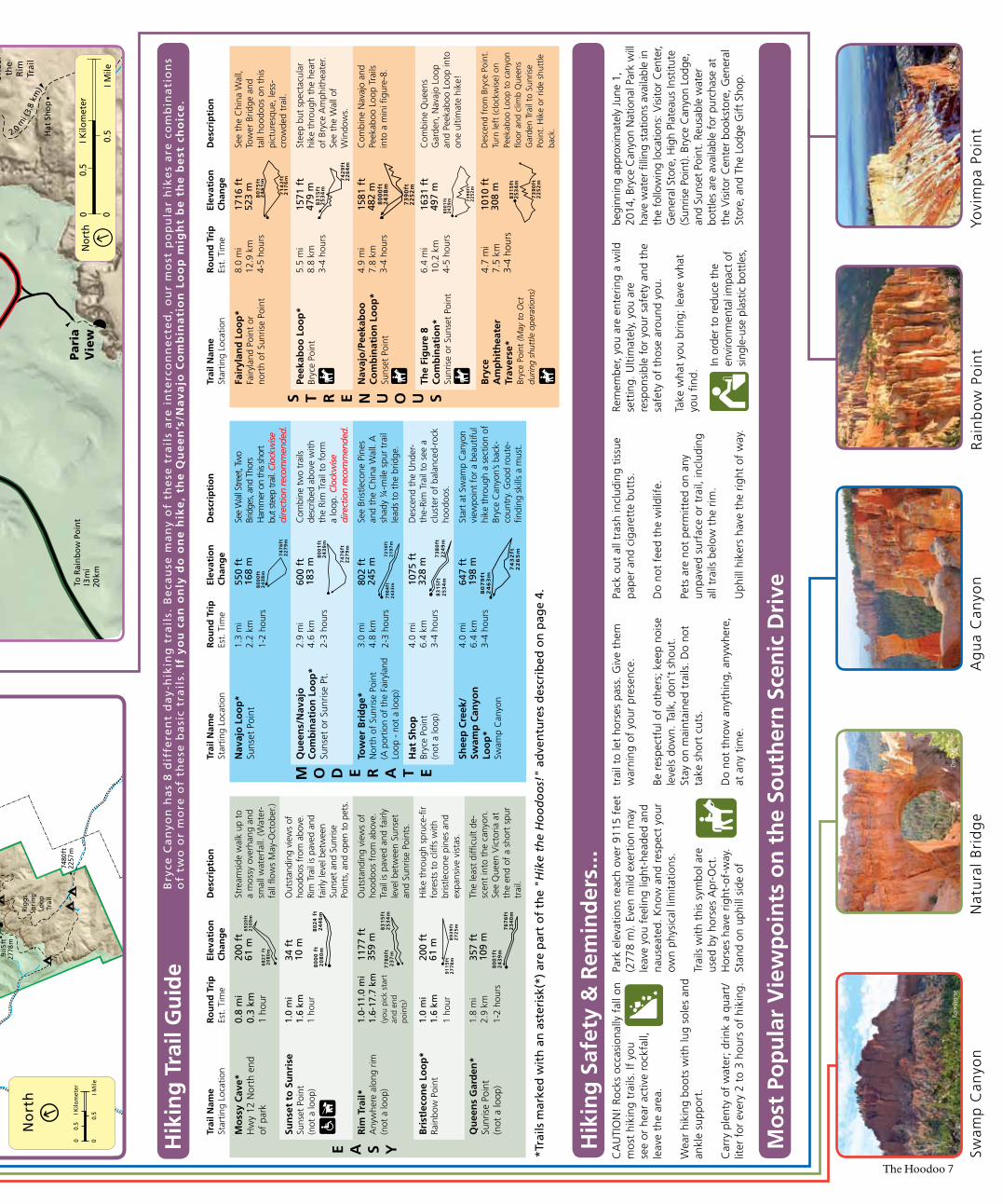
Fairyland Loop Trail (Photo: Brian B. Roanhorse) Visitor Center Hours Summer 8 a.m. – 8 p.m. Fall/Spring 8 a.m. – 6 p.m. Map, Shuttle & Hiking Guide Summer 2014 Visitor Center Stop at the Visitor Center for information, museum exhibits, and a 22-minute award- winning orientation film, shown daily 8:00 a.m. to closing, on the hour and half hour. Tour Our Famous Viewpoints Between 8 am & 7 pm, ride the shuttle to Bryce, Inspiration, Sunset and Sunrise Points first. If you have more time, use your car to visit overlooks in the southern portion of the park. Short Walk Hike a short segment of the Rim Trail or select one of the hikes from the “Easy to Moderate” group in the hiking table on page 7. Have Less Than 4 Hours? Short Walks and Day Hikes Bryce is best experienced from its trails. Select one of the combination loops from the “Moderate” or “Strenuous” groups in the hiking table on page 7. Ranger Programs Attend a free Ranger Program to learn more about the natural and cultural history of this region. Check at the Visitor Center for the current program schedule. Horseback Ride Take a horse ride into Bryce Canyon. Wranglers lead 2-hour and half-day rides daily. Inquire at Bryce Canyon Lodge. Enjoy a Complete Day Where is the best overlook? There are 14 viewpoints along Bryce Canyon’s 18-mile scenic drive (one-way distance) and everybody determines his or her favorite for a multitude of reasons. For every 15 minutes you extend your visit, you can see another overlook! If you stop at all the viewpoints, it could take as little as 3-4 hours. Our most famous views, best accessed using the Bryce Canyon Shuttle, are found in Bryce Amphitheater, including Sunrise, Sunset, Inspiration and Bryce points. The southern overlooks feature beautiful, though smaller, amphitheaters and/or long-distance, panoramic views across the Grand Staircase-Escalante National Monument. From many of the park's overlooks you can see over 100 miles (160 km) on a clear day! Since all the viewpoints are on the left side of the road as you drive south towards Rainbow Point, we recommend stopping at the viewpoints as you drive north on your return trip. This way, each stop will be an easier and safer right turn. Getting Around the Park What’s Inside The Hoodoo Bryce Canyon National Park Service U.S. Department of the Interior Accessibility . . . . . . . . . . . . . . . . . 2 Geology . . . . . . . . . . . . . . . . . 8 Hike the Hoodoos! . . . . . . . . . . . 4 Hiking Guide. . . . . . . . . . . . . . . . . 7 History . . . . . . . . . . . . . . . . . 9 Information & Services . . . . . . . . 2 Lightning . . . . . . . . . . . . . . . . . 10 Natural History Association . . .11 Nearby Attractions . . . . . . . . . . 12 Night Skies . . . . . . . . . . . . . . . . 5 Partners & Donors. . . . . . . . . . . 11 Park Map . . . . . . . . . . . . . . . . . . 6,7 Park Profile . . . . . . . . . . . . . . . . 4 Prescribed Fire . . . . . . . . . . . . . . 10 Ranger Programs . . . . . . . . . . . . 3 Safety . . . . . . . . . . . . . . . . . . . . . 3 Shuttle . . . . . . . . . . . . . . . . . . 5 Volunteers . . . . . . . . . . . . . . . 11 Weather . . . . . . . . . . . . . . . . . . . 10 Wildlife . . . . . . . . . . . . . . . . . . . . 9 EMERGENCY INFORMATION PAGE 3 Questions? Bring this newspaper to the Visitor Cen ter Desk! • Hydration Stations coming early summer 2014! See page 5 for information and locations. • Safety First! Make your visit to Bryce Canyon a safe one! Turn to page 3. • Hoodoo You Love? Find out on page 11. • Bryce Canyon Shuttle runs early May to early October. See page 5 for more information. • Hike the Hoodoos see page 4 for program rules.
Transcript
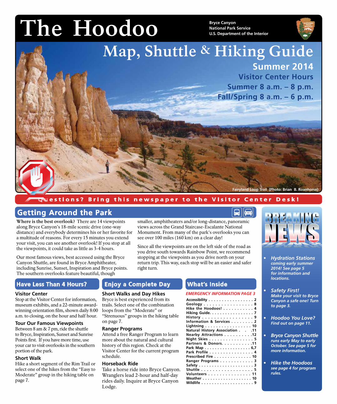
Fairyland Loop Trail (Photo: Brian B. Roanhorse)
Visitor Center HoursSummer 8 a.m. – 8 p.m.
Fall/Spring 8 a.m. – 6 p.m.
Map, Shuttle & Hiking Guide Summer 2014
Visitor CenterStop at the Visitor Center for information, museum exhibits, and a 22-minute award-winning orientation film, shown daily 8:00 a.m. to closing, on the hour and half hour.
Tour Our Famous ViewpointsBetween 8 am & 7 pm, ride the shuttle to Bryce, Inspiration, Sunset and Sunrise Points first. If you have more time, use your car to visit overlooks in the southern portion of the park.
Short WalkHike a short segment of the Rim Trail or select one of the hikes from the “Easy to Moderate” group in the hiking table on page 7.
Have Less Than 4 Hours?
Short Walks and Day HikesBryce is best experienced from its trails. Select one of the combination loops from the “Moderate” or “Strenuous” groups in the hiking table on page 7.
Ranger ProgramsAttend a free Ranger Program to learn more about the natural and cultural history of this region. Check at the Visitor Center for the current program schedule.
Horseback RideTake a horse ride into Bryce Canyon. Wranglers lead 2-hour and half-day rides daily. Inquire at Bryce Canyon Lodge.
Enjoy a Complete Day
Where is the best overlook? There are 14 viewpoints along Bryce Canyon’s 18-mile scenic drive (one-way distance) and everybody determines his or her favorite for a multitude of reasons. For every 15 minutes you extend your visit, you can see another overlook! If you stop at all the viewpoints, it could take as little as 3-4 hours.
Our most famous views, best accessed using the Bryce Canyon Shuttle, are found in Bryce Amphitheater, including Sunrise, Sunset, Inspiration and Bryce points. The southern overlooks feature beautiful, though
smaller, amphitheaters and/or long-distance, panoramic views across the Grand Staircase-Escalante National Monument. From many of the park's overlooks you can see over 100 miles (160 km) on a clear day!
Since all the viewpoints are on the left side of the road as you drive south towards Rainbow Point, we recommend stopping at the viewpoints as you drive north on your return trip. This way, each stop will be an easier and safer right turn.
Getting Around the Park
What’s Inside
The Hoodoo Bryce Canyon National Park Service U.S. Department of the Interior
Q u e s t i o n s ? B r i n g t h i s n e w s p a p e r t o t h e V i s i t o r C e n t e r D e s k !
• Hydration Stations coming early summer 2014! See page 5 for information and locations.
• Safety First! Make your visit to Bryce Canyon a safe one! Turn to page 3.
• Hoodoo You Love? Find out on page 11.
• Bryce Canyon Shuttle runs early May to early October. See page 5 for more information.
• Hike the Hoodoos see page 4 for program rules.
Information and Services
2 The Hoodoo
Visitor Center In summer, open 8:00 am - 8:00 pm. Information, museum, publications, an award-winning film,
backcountry permits, and lost-and-found services are available here.
Emergencies 24-hour emergency response, call 911 or 435 676-2411. Garfield Hospital, 435 676-8811, and Clinic, 435 676-8842 are in Panguitch.
Accessibility Restrooms: the Visitor Center, Sunset Point, Bryce Canyon Lodge, and General Store are fully accessible. Sunset
Campground has two sites reserved for people with mobility impairments. The ½-mile section of Rim Trail between Sunset and Sunrise points is paved and mostly level. Inquire at the Visitor Center for information on accessible ranger-led programs, and to obtain an Access Guide.
Restrooms Available year-round at the Visitor Center, North Campground, Mossy Cave Trail, and Sunset, Farview, and
Rainbow points. Restrooms are also available April – October at Bryce Canyon Lodge, General Store, Sunset Campground, Inspiration Point, and Peekaboo Loop.
Telephone & Wireless ServicePublic pay phones are available year-round in Bryce Canyon City. Wireless carriers have
towers in the region, however service is not always available in many areas within the park.
Wireless Internet (WiFi) Free wireless Internet access is available year-round at the Visitor Center or seasonally
for lodge guests at the Bryce Canyon Lodge lobby (password required).
Post Office/ATM/InternetRuby’s Inn has a post office open Mon-Sat (Bryce, UT 84764), an ATM, and internet
services. Personal mail addressed to park visitors will not be accepted at Bryce Canyon National Park.
Pets Pets must be leashed; you are required to clean up after your pet. Pets are permitted at park viewpoints, campgrounds,
and on paved surfaces or paved trails. Pets are not permitted in buildings or on unpaved surfaces including all trails below the rim.
Horseback Riding Wranglers lead 2-hour and 4-hour horse and mule rides Spring – October (weather and trail
conditions permitting). For same-day reservations, inquire at Bryce Canyon Lodge or call 435 834-5500. For advance reservations: Canyon Trail Rides, P.O. Box 128, Tropic, UT 84776; 435 679-8665. Information: www.canyonrides.com.
Entrance Fees Private Vehicle: $25 per vehicle, valid for 7 days in Bryce Canyon National Park.
Individual: $12 per person (pedestrian, bicycle, motorcycle, and organized group), valid for 7 days in Bryce Canyon National Park.Bryce Canyon Annual Pass: $30, valid for one year from date of purchase at Bryce Canyon National Park only.Commercial Tours: Ask for rates.Interagency Annual Pass: $80, valid for one year from date of purchase in all federal fee areas.Interagency Senior Pass: $10 lifetime pass for U.S. residents 62 or older.Interagency Access Pass: Free lifetime pass for U.S.residents who are permanently disabled.Annual Pass - Military: Free pass valid one year to active U.S. military and dependents.
Camping North Campground: Open all year, 101 campsites (only one loop open in winter). Available first-come,
first-served Oct 1 – May 8. RV sites may be reserved May 9 – Sept 21 by calling 877 444-6777 or visit www.recreation.gov. Reservations can be made up to 240 days in advance.Sunset Campground: Open late spring to early fall, 102 campsites. 20 tent sites are available for reservation up to 6 months in advance, all others first-come, first served.Fees: Camping is $15 a night per campsite (half price for Interagency Senior and Access pass holders). Group Campsite: One site available by reservation only. Group size is limited to 7-30 people and 8 vehicles. Cost is $55-$100 per night, dependent upon group size. Campsite may be reserved by calling 877 444-6777 or online at www.recreation.gov.Dump Station: No hookups are in the park, but a fee-for-use dump station is available in summer near North Campground.Other Campgrounds: For camping reservations in nearby federal lands (National Parks, US Forest Service, BLM), call 877 444-6777 or visit www.recreation.gov. Public campgrounds are also available onUtah State Park lands nearby (stateparks.utah.gov/reservations or call 800-322-3770). Private campgrounds with showers and hookups are available outside the park.
Picnic Areas Picnic areas are available year-round at Sunset Point, the General Store, Rainbow Point, and Mile 4.5
of the park road, and from April – October at the south end of North Campground. Water is available seasonally at all of the above locations except Mile 4.5 and Rainbow Point. Fire grates are available only at the North Campground Picnic Area.
Religious Services Outside the park year-round, may be available in the park during summer months. For more
information, inquire at the Visitor Center or the Bryce Canyon Lodge.
LodgingThe Lodge at Bryce Canyon: Open March 28 - November 8, 2014. Cabins,
motel rooms and suites, a restaurant, and gift shop. For lodging reservations, write to: The Lodge at Bryce Canyon, P.O. Box 640041, Bryce Utah 84764, call 877-386-4383; or visit brycecanyonforever.com.Other Lodging: Available near the park entrance in Bryce Canyon City and in Tropic, Cannonville, Bryce Junction, and Panguitch.
Food Services The Lodge at Bryce Canyon: Open March 28 - November 8, 2014. Dining room serves
breakfast, lunch, and dinner. Valhalla Pizzeria is open mid-May to mid-October. The General Store, open late March to early November, has groceries, quick meals, and camper supplies.Other Food Services: Restaurants are available near the park entrance and in Tropic, Bryce Junction, and Panguitch.
Showers & Laundry Coin-operated shower and laundry facilities are available at the General Store,
open late March - early Nov., and outside the park at some nearby establishments.
Bicycles Bicycles are restricted to paved roadways in the park. The nearby Dixie National Forest has a paved bicycle
path through Red Canyon, and many miles of challenging and spectacular mountain bike trails. Grand Staircase-Escalante National Monument has countless miles of dirt roads suitable for mountain biking.
Recycling Recycling bins are located at the entrance to Sunset & North campgrounds, Sunset Point, Visitor
Center, General Store and Bryce Canyon Lodge. Now accepting aluminum cans, plastic (#1–7), cardboard, tin, and glass. Receptacles for recycling small propane cylinders are available at North Campground, Sunset Campground, and the General Store.
Backcountry Hiking Bryce Canyon has two trails designated for overnight hiking: the 9-mile Riggs Spring
Loop, and the 23-mile Under-the-Rim Trail. Backcountry permits are on a first-come, first-served basis; fees range from $5 – $15 depending upon group size. Permits may be purchased at the Visitor Center from 9:00 a.m. – 12:30 p.m. and 1:30 p.m. – 6:00 p.m. daily. There are two group sites available with a limit of 15 people per site. For detailed information scan the QR Code at right to download a pdf copy to your smart phone or tablet, or obtain a copy from the Visitor Center.
The Hoodoo 3
National Park Service U.S. Department of the InteriorEmergencies Call 911 or 435-676-2411
24–hours a day or contact a Park RangerPark Headquarters435 834-5322Fax 435 834-4703Lost & Found: 435 834-4736
Travelers Information Stations: Tune radio to 1590 and 1610 AM for park and shuttle information
Astronomy Programs Join Dark Rangers, Volunteers, and NASA Solar System Ambassador Patrick Wiggins, to learn about the heavens, and view Bryce’s night skies through telescopes (weather permitting). Ask at the Visitor Center or look on page 5 for additional information. Duration: 2 hours
Kids Programs (June – August) While most of Bryce Canyon’s ranger programs are fam-ily friendly, some may be too technical for younger children. However, these are fun for kids and parents alike. Rangers present a wide range of programs ap-pealing to a variety of interests. Most Kids Programs, offered occasionally, require reservations – inquire at the Visitor Center. Duration: 1 hour
Full Moon Hike Group size is limited to 30 people; get your first-come first-served tickets at the Visitor Center the morning of the hike. Hiking shoes or boots with good traction are REQUIRED - no exceptions. 1.5 to 2 miles, Duration: 2 to 2.5 hours
Fortunately, Bryce averages less than 1 fatality per year. In order of decreasing occurrence, fatalities are caused by:
Unfortunately, hundreds of serious injuries have also needlessly occurred, often from ignoring park safety warnings.
Top 10 Causes of Bryce Injuries#10 Unsafe Driving• Speeding (posted limits are 15 to 45 mph).• Failure to wear seat belts. • Passing on a double yellow line. • Auto vs. animal. Watch for Wildlife!• Rear-ending. Stop in pullouts, never in road. • Not reducing speed on wet or icy roads.
#9 Climbing / Sliding down cliffsThe rock at Bryce forms crumbly cliffs and steep gravely slopes. Hand and toe holds support nothing heavier than chipmunks. Climbing the rocks and sliding on the slopes is not only illegal but also dangerous.
#8 Feeding AnimalsFed animals become aggressive. Even small animals can inflict bites requiring stitches and worse yet transmit disease. Watch wildlife from a distance and discourage animals that approach you.
#7 Ignoring Extreme WeatherAt Bryce it is possible for the difference between the daily high and low to be as much as 50° F / 27° C! Lightning is a year-round danger – especially during summer storms! If you can hear thunder, lightning is within 10 miles (16 km) and you need to seek the shelter of a building or your vehicle immediately. See page 10 for more. #6 Dehydration Drink 1 quart / liter every 1-2 hours. A well hydrated body is better able to regulate body temperature and is more resistant to heat exhaustion. Sunburns also lead to dehydration. Wear a hat, sunscreen, and sunglasses to protect from the sun overhead and reflected UV light. Hydration Stations to fill your water bottles are found in several locations in the park - see page 5 or look for this symbol on the map in this newspaper.
#5 Leaving the Trail Stay on designated trails and away from cliff edges where footing can be tricky. Even on seemingly gentle slopes, it can be impossible to keep your footing. Bring the maps on page 6 and 7 to avoid getting lost.
#4 Over-exertion Park elevations reach 9115 ft (2778 m) subjecting you to 70% of the oxygen you might be used to. Bryce’s trails start at the top which means all returns will be uphill. Turn back BEFORE you become tired. Know and respect your own physical limitations.
#3, #2, & #1 Bad Choice of Footwear Wear hiking boots with good ankle support and “lug” traction. Sport-sandals & “trainers” are NOT safe hiking footwear. Wearing shoes or boots not designed for hiking is the NUMBER ONE cause of rescues and injuries that require hospital visits at Bryce Canyon National Park.
Become a Junior Ranger!Attending a ranger program is the #1 requirement toward completion of your Junior Ranger workbook. Ask how you can become a Bryce Canyon Junior Ranger at the Visitor Center and, while you are there, check the schedule of upcoming ranger programs.
Ranger Daniel’s Safety Tips Ranger-led Activities
Geology Talk Hoodoos, ancient lakes and something called frost wedging? Geologists have spent years studying the unique story of Bryce Canyon. Spend a half hour with a ranger as we discuss the current scientific explanation behind Bryce Canyon’s unique geologic history.Sunset Point Duration: 30 minutes
Rim Walk Great views, plant and wildlife stories, a touch of geology, a smattering of cultural history – what more could you want? Join a park ranger for an overview of Bryce Canyon as you stroll along the rim of the Bryce Amphitheater. Daily in the late afternoon June – September, check at the Visitor Center for start times. 1 mile, Duration: 1.5 hours
Evening Program Bryce Canyon’s diversity comes to life during ranger programs at the Bryce Canyon Lodge, Visitor Center auditoriums, or North Campground Amphitheater (weather permitting). Auditoriums are wheelchair accessible, access to the North Campground facility may require additional assistance. Duration: 1 hour
Canyon Hike (June – August) Join a park ranger for a hike down into the heart of the Bryce Amphitheater. Enjoy face to face encounters with hoodoos. Immerse yourself in a labyrinth of breathtaking views and engaging stories about all that surrounds you. Offered occasionally – inquire at Visitor Center. Length: 1.5 to 2 miles
Check at the Visitor Center for program locations and start times!
4 The Hoodoo
Established 1923 as Bryce Canyon National Monument administered by the U.S. Forest Service; Congress passed legislation in 1924 to create the national park and, in 1928, Bryce Canyon National Park was officially established.
Significance Established to preserve and protect outstanding scenic and scientific values. Best known for the beautiful and bizarre rock spires called hoodoos and the dark night sky.
Hoodoo [hoo’doo] n. 1. A pinnacle or odd-shaped rock left standing by the forces of erosion. 2. v. To cast a spell or cause bad luck. 3. Voodoo.
Elevation/Size Lowest: 6,620 feet (2018 m) Yellow Creek. Highest: 9,115 feet (2778 m) at Rainbow Point.Area: 55 square miles (35,835 acres)
Name Ebenezer and Mary Bryce lived in the area from 1875-1880 and aided in the settlement of southwestern Utah and northern Arizona.
Humans Archaeological studies indicate Ancestral Puebloans probably lived in the area from 2,000 years ago, followed by the Fremont Culture through the 1200s. This region remains the ancestral homeland of the Southern Paiute. Mormon settlers arrived in the 1870s. Park visitation in 1929 was 22,000; last year it was 1.4 million.
Plant Life More than 400 native plant species live in the park. Pinyon pine and juniper grow among the hoodoos at low elevations; ponderosa pine forests dominate the plateau top; fir and aspen thrive at the highest elevations. Bristlecone pines, some more than 1,600 years old, live at various elevations throughout the park.
Animal Life Utah Prairie Dogs, a federally threatened species, can be seen in open meadows. Mule Deer and Pronghorn (mistakenly known as Antelope) are the most common large mammals seen. Mountain Lions and Black Bears live in the park, but are rarely seen. Over 200 species of birds visit Bryce.
Bryce Canyon Lodge Designed by Gilbert Stanley Underwood and built in 1924, it is a National Historic Landmark. Of the four lodges in the Union Pacific Loop Tour (Bryce Canyon, Cedar Breaks, Zion, and Grand Canyon-North Rim), the Bryce Canyon Lodge is the only original of these structures still standing.
I Hiked the Hoodoos Program Park Profile
Benchmark Distance miles km
Mossy Cave 0.8 1.3
Rim Trail 2.5 4.0
Tower Bridge 3.0 4.8
Queens Garden 1.8 2.9
Navajo Loop 1.3 2.2
Peekaboo (from Sunset Point) 2.4 3.9
Wall of Windows (from Bryce Point) 1.6 2.6
Sheep Creek 4.0 6.4
Bristlecone Loop 1.0 1.6
Trail difficulty: Easy, Moderate, Strenuous
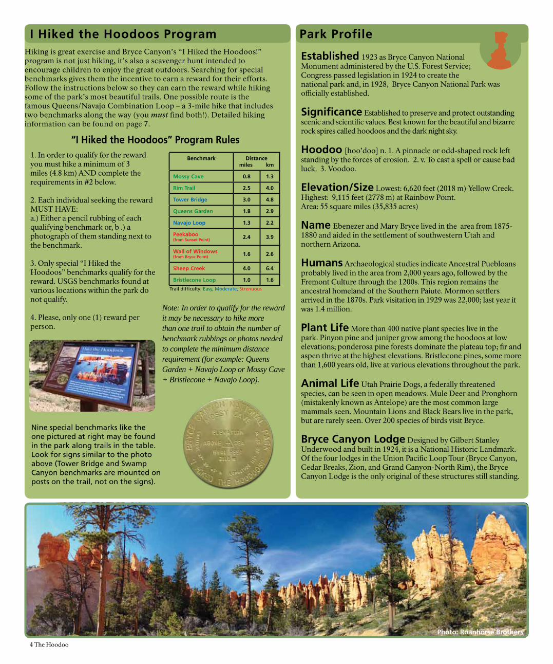
Hiking is great exercise and Bryce Canyon’s “I Hiked the Hoodoos!” program is not just hiking, it’s also a scavenger hunt intended to encourage children to enjoy the great outdoors. Searching for special benchmarks gives them the incentive to earn a reward for their efforts. Follow the instructions below so they can earn the reward while hiking some of the park’s most beautiful trails. One possible route is the famous Queens/Navajo Combination Loop – a 3-mile hike that includes two benchmarks along the way (you must find both!). Detailed hiking information can be found on page 7.
Nine special benchmarks like the one pictured at right may be found in the park along trails in the table. Look for signs similar to the photo above (Tower Bridge and Swamp Canyon benchmarks are mounted on posts on the trail, not on the signs).
“I Hiked the Hoodoos” Program Rules
Note: In order to qualify for the reward it may be necessary to hike more than one trail to obtain the number of benchmark rubbings or photos needed to complete the minimum distance requirement (for example: Queens Garden + Navajo Loop or Mossy Cave + Bristlecone + Navajo Loop).
1. In order to qualify for the reward you must hike a minimum of 3 miles (4.8 km) AND complete the requirements in #2 below.
2. Each individual seeking the reward MUST HAVE:a.) Either a pencil rubbing of each qualifying benchmark or, b .) a photograph of them standing next to the benchmark.
3. Only special “I Hiked the Hoodoos” benchmarks qualify for the reward. USGS benchmarks found at various locations within the park do not qualify.
4. Please, only one (1) reward per person.
Photo: Roanhorse Brothers
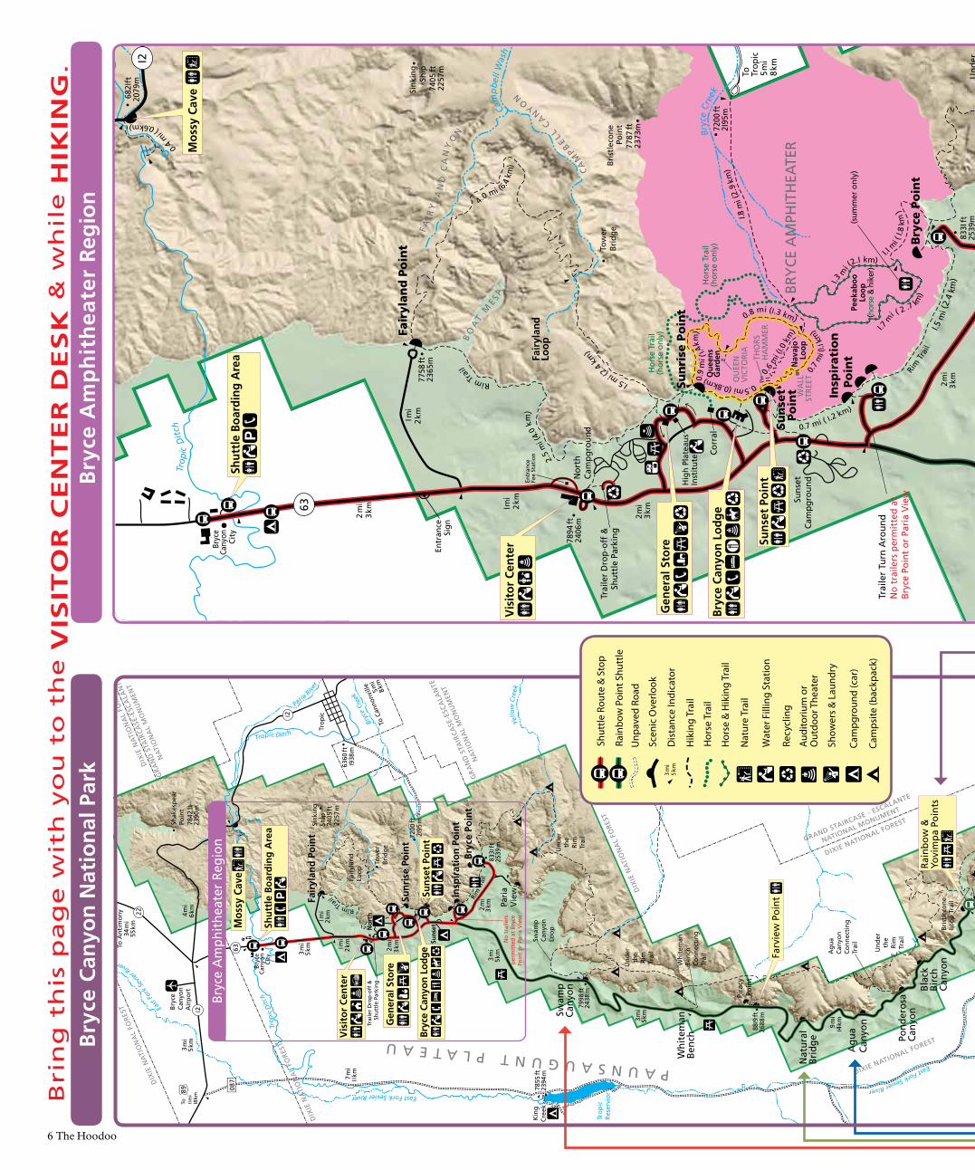
Bryce Canyon Shuttle
Visitor Center Visitor Center
Ruby’s
Sunset PointBryce Lodge
Sunrise Point
Sunset
Bryce Point
Inspiration Point
Sunset
Shuttle Parking
Ruby’s Inn Grand Hotel FREE SHUTTLE!Bryce Amphitheater Route
2014 Season: May 9 – October 12Hours:
8 am – 7 pm May 9 – 22 8 am – 8 pm May 23 – September 138 am – 7 pm September 14 – October 48 am – 6 pm October 5 – October 12
Bus Interval:8 – 10 am: 20 mins10 am - 5 pm: 10-15 min6 pm – close: 20 mins (except May 9–22: 4 pm-close and Sep 14 - Oct 12: 5 pm-close)
The Bryce Canyon Shuttle is voluntary. Riding the shuttle reduces traffic, conserves fuel, saves time, money, and helps protect the planet! Shuttle buses are fully accessible. Pets are not allowed.
Rainbow Point Tour: In addition, two free round-trip tours to Rainbow Point are offered most days, one in the morning and one in the afternoon. For further information, inquire at the Shuttle Boarding Area outside the park or at the Visitor Center.
For tour reservations call 435-834-5290.
LAST BUS Enters Park Leaves Bryce Pt. Leaves Park
May 9 – 22 6:21 pm 6:32 pm 6:54 pm
May 23 – Sep 13 7:21 pm 7:32 pm 7:54 pm
Sep 14 – Oct 4 6:21 pm 6:32 pm 6:54 pm
Oct 5 – Oct 12 5:21 pm 5:32 pm 5:54 pm(Note: All times are approximate and subject to change.)
8:30pm Start TimesMay 6 - May 29
9:00pm Start TimesMay 31 - August 9*
8:30pm Start TimesAug. 12 - September 13
7:30pm Start TimesSept. 16 - Oct 30
Join us for our 14th Annual Astronomy Festival from June 25 - 28, 2014. Bryce Canyon National Park and the Salt Lake Astronomical Society welcome photographer Alex Cherney from Australia as the festival's keynote speaker. Other special guests, along with Bryce Canyon's Dark Rangers, will present a full slate of programs on the other nights during the festival. Each night's programs are followed by stargazing with telescopes!
Bryce Canyon National Park celebrates the night sky most Tuesdays, Thursdays, and Saturdays throughout the summer and into fall. Each night begins with a choice of two 1-hour multimedia shows, each with different night-sky related topics. Check at the Visitor Center and choose the show and location that most interests you.
After the indoor presentations, it's out to the telescopes to enjoy the real sky! Remember to bring warm clothes. Even in August, temperatures may dip down as low as 40° F / 4° C!
Though the multimedia shows are never cancelled, stargazing is weather-dependent.
*No astronomy program will be offered Saturday July 26.
Starry Nights
Astronomy Festival June 2014
The Dark Rangers' Summer/Fall Night-Sky Program Schedule
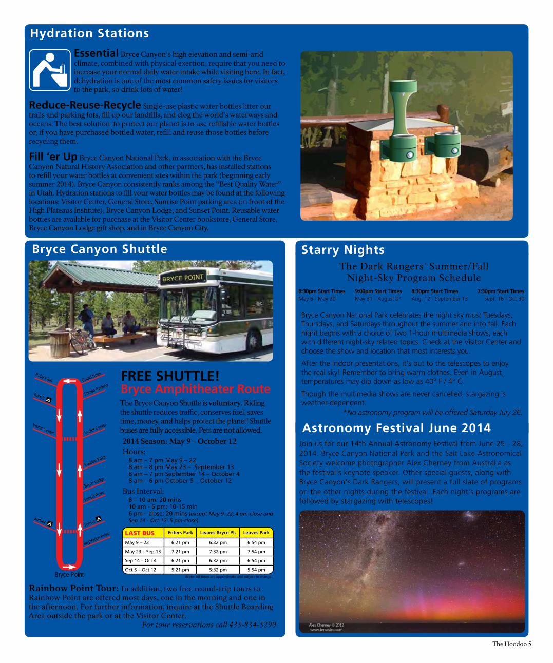
Hydration Stations
Essential Bryce Canyon’s high elevation and semi-arid climate, combined with physical exertion, require that you need to increase your normal daily water intake while visiting here. In fact, dehydration is one of the most common safety issues for visitors to the park, so drink lots of water!
Reduce-Reuse-Recycle Single-use plastic water bottles litter our trails and parking lots, fill up our landfills, and clog the world’s waterways and oceans. The best solution to protect our planet is to use refillable water bottles or, if you have purchased bottled water, refill and reuse those bottles before recycling them.
Fill ‘er Up Bryce Canyon National Park, in association with the Bryce Canyon Natural History Association and other partners, has installed stations to refill your water bottles at convenient sites within the park (beginning early summer 2014). Bryce Canyon consistently ranks among the “Best Quality Water” in Utah. Hydration stations to fill your water bottles may be found at the following locations: Visitor Center, General Store, Sunrise Point parking area (in front of the High Plateaus Institute), Bryce Canyon Lodge, and Sunset Point. Reusable water bottles are available for purchase at the Visitor Center bookstore, General Store, Bryce Canyon Lodge gift shop, and in Bryce Canyon City.
The Hoodoo 5
Bri
ng
th
is p
ag
e w
ith
yo
u t
o t
he
VIS
ITO
R C
EN
TE
R D
ES
K &
wh
ile
HIK
ING
.B
ryce
Am
ph
ith
eate
r R
egio
n
Pari
aV
iew
Insp
irat
ion
Po
int
2 m
i3
kmI mi
2 km
I m
i2
km
Fair
ylan
d P
oin
t
Nor
thCa
mpg
roun
d
Fair
ylan
dLo
op
Und
erth
eRi
mTr
ail
Trai
ler
Dro
p-of
f &
Shut
tle
Park
ing
63
I2
Trai
ler
Turn
Aro
und
No
trai
lers
per
mit
ted
atBr
yce
Poin
t or
Par
ia V
iew
Bry
ce P
oin
t
Sink
ing
Ship
7405
ft22
57m
Tow
erBr
idge
Rim
Tra
il
Rim Trai
l
2 m
i 3
km77
58 ft
2365
m
7894
ft24
06m
682I
ft20
79m
833I
ft25
39m
BO
AT
ME S
A
Trop
ic D
itch
Cam
pbel
l Was
h
Bryc
e Cr
eek
Bris
tlec
one
Poin
t Hat
Sho
p
Corr
al
Hig
h Pl
atea
usIn
stit
ute
PAUNSAUGUNT PLATEAU
Hor
se T
rail
(hor
se o
nly)
Pe
ekab
oo
L
oop
(hor
se &
hik
er)
2.5
mi (
4.0
km)
4.0 mi (6
.4 k
m)
I.5 mi (2
.4 k
m)
0.6
mi (
I.0 k
m)
I.8 m
i (2.
9 km
)
I.5 m
i (2.
4 km
)
0.7 mi ( I.2 km)
0.5mi (0.8km)
I.I
mi (
I.8
km )
2.0 m
i (3.
8 km
)
0.9
mi (
I.4k
m)
0.8 mi (I.3 km)
QU
EEN
VIC
TORI
A
Que
ens
I.3 m
i (2.I km)
I.7 m
i ( 2 .7 km
)
Nav
ajo
Loop
CA
MPB
ELL CA
N
YO
N
FAI R
YL A
ND
CA
NY
ON 72
00 ft
2I95
m
7787
ft23
73m
To R
ainb
ow P
oint
I 3 m
i20
kmEn
tran
ceSi
gn
To Trop
ic5
mi
8 km I
20.4
mi (
0.6km)
Hor
se T
rail
(hor
se o
nly)
2 m
i3
km
BRY
CE A
MPH
ITH
EATE
R0.
7 m
i (I.I
km
)
THO
RSH
AM
MER
WA
LLST
REET
Entr
ance
Fee
Stat
ion
(sum
mer
onl
y)
Sun
rise
Po
int
Sun
set
Po
int
Suns
etCa
mpg
roun
d
Shut
tle
Boar
ding
Are
a
Bryc
e Ca
nyon
Lod
ge
Gen
eral
Sto
reBryc
eCa
nyon
City
KPOE
Bryc
e A
mph
ithe
ater
Reg
ion N
orth
0
I Mile
I Kilo
met
er0.
5
0.5
0
Vis
itor
Cen
ter
Mos
sy C
ave
Suns
et P
oint
Gar
den
Trai
ler
Dro
p-o
ff &
Shu
ttle
Par
kin
g
Bri
stle
con
eLo
op
Tra
il
Rig
gs
Spri
ng
Loo
pTr
ail
9 I I
5 ft
2778
m
Ag
ua
Can
yon
Nat
ura
lB
rid
ge
Pira
cyPo
int
Pari
aV
iewIn
spir
atio
n P
oin
t
Sun
rise
Po
int
Suns
et
Bry
ceC
anyo
nA
irp
ort
3 m
i5
km
2 m
i 3
km
2 m
i3
kmI mi
2 km
I m
i2
km
3 m
i5
kmTo A
nti
mo
ny
34 m
i55
km
Fair
ylan
d P
oin
t
No
rth
Swam
pC
anyo
nLo
op
Fair
ylan
dLo
op
4 m
i6
km
Kin
gC
reek
3 m
i5
km
9 m
iI4
km
Un
der
the
Rim
Trai
l
Un
der
the
Rim
Trai
l
Un
der
the
Rim
Trai
l
63
I2
Pa
ria R
iver
Trop
ic D
itch
Tro
pic
Res
ervi
or
I2
3 m
i5
km
7998
ft24
38 m
7200
ft 2
I95
m
Tro
pic
88I9
ft 2
688
m
833 I
ft25
39 m
Shee
p C
reek
Will
is C
reek
Eas
t For
k Se
vier R
iver
East Fork Sevier River
East Fork Sevier River
6360
ft I
938
m
Tropic Ditch
Bryc
e Cr
eek
7 m
iI I
km
Yello
w C
reek
To I I m
iI8
km
89 087
To C
anno
nvill
e5 m
i
8 km
Bry
ce P
oin
t
Swam
pC
anyo
n
Wh
item
anB
ench
22
Sin
kin
gSh
ip74
05 ft
2257
m
7480
ft22
57 m
Tow
erB
rid
ge
7855
ft23
94 m
Shak
esp
ear
Poin
t78
42 ft
2390
m
DIX
IE N
ATI
ON
AL
FORE
ST
DIXIE NATIONAL FOREST
DIXIE NATIONAL FOREST
DIX
IE N
ATI
ON
AL
FORE
ST
GRAND STAIRCASE - ESCALANTE
NATIONAL MONUMENT
GRA
ND
STA
IRCA
SE-E
SCA
LAN
TE
NA
TIO
NA
L M
ON
UM
ENT
GRA
ND
STA
IRCA
SE-E
SCA
LAN
TE
NA
TIO
NA
L M
ON
UM
ENT
PAUNSAUGUNT PLATEAU
DIX
IE N
ATI
ON
AL
FORE
ST
DIX
IE N
ATI
ON
AL
FORE
ST
Rim
Tra
il
Rim Tr
ail
Ag
ua
Can
yon
Co
nn
ecti
ng
Tr
ail
Wh
item
anB
ench
Co
nn
ecti
ng
Tr
ail
No
tra
ilers
per
mit
ted
at
Bry
cePo
int
or
Pari
a V
iew
Bry
ceC
anyo
nC
ity
Pon
der
osa
Can
yon
Bla
ckB
irch
Can
yon
Gen
eral
Sto
re
Bryc
e Ca
nyon
Lod
ge
Shu
ttle
Bo
ard
ing
Are
a
KPO
E
Rai
nb
ow
&Yo
vim
pa
Poin
ts
Vis
ito
r C
ente
r
Farv
iew
Po
int
No
rth
0 0I M
ile
I Kilo
met
er0.
5
0.5
Bryc
e A
mph
ithe
ater
Reg
ion
Mos
sy C
ave
Sun
set
Poin
t
Bry
ce C
anyo
n N
atio
nal
Par
k
Cam
psite
(bac
kpac
k)
Dis
tanc
e In
dica
tor
3 m
i5
km
Hik
ing
Trai
l
Nat
ure
Trai
l
Unp
aved
Roa
d
Scen
ic O
verlo
ok
Hor
se T
rail
Shut
tle R
oute
& S
top
Hor
se &
Hik
ing
Trai
l
Cam
psite
(bac
kpac
k)
Dis
tanc
eIn
dica
tor
3 mi
5 km
Hik
ing
Trai
l
Cam
pgro
und
(car
)
Emer
genc
y Te
leph
one
Nat
ure
Trai
l
Show
ers
& L
aund
ry
Aud
itoriu
m o
r
Gro
cery
Sto
re
Unp
aved
Roa
d
Scen
ic O
verlo
ok
Pave
d Ro
ad(n
ot p
low
ed in
win
ter)
Ski T
rail
(gro
omed
)
Ski T
railh
ead
Ski T
rail
(not
gro
omed
)
Hor
se T
rail
Rain
bow
Poi
nt S
hutt
le
Cam
pgro
und
(car
)
Show
ers
& L
aund
ry
Aud
itoriu
m o
r O
utdo
or T
heat
er
Recy
clin
g
Wat
er F
illin
g St
atio
n
6 The Hoodoo
Pari
aV
iew
Insp
irat
ion
Po
int
2 m
i3
kmI mi
2 km
I m
i2
km
Fair
ylan
d P
oin
t
Nor
thCa
mpg
roun
d
Fair
ylan
dLo
op
Und
erth
eRi
mTr
ail
Trai
ler
Dro
p-of
f &
Shut
tle
Park
ing
63
I2
Trai
ler
Turn
Aro
und
No
trai
lers
per
mit
ted
atBr
yce
Poin
t or
Par
ia V
iew
Bry
ce P
oin
t
Sink
ing
Ship
7405
ft22
57m
Tow
erBr
idge
Rim
Tra
il
Rim Trai
l
2 m
i 3
km77
58 ft
2365
m
7894
ft24
06m
682I
ft20
79m
833I
ft25
39m
BO
AT
ME S
A
Trop
ic D
itch
Cam
pbel
l Was
h
Bryc
e Cr
eek
Bris
tlec
one
Poin
t Hat
Sho
p
Corr
al
Hig
h Pl
atea
usIn
stit
ute
PAUNSAUGUNT PLATEAU
Hor
se T
rail
(hor
se o
nly)
Pe
ekab
oo
L
oop
(hor
se &
hik
er)
2.5
mi (
4.0
km)
4.0 mi (6
.4 k
m)
I.5 mi (2
.4 k
m)
0.6
mi (
I.0 k
m)
I.8 m
i (2.
9 km
)
I.5 m
i (2.
4 km
)
0.7 mi ( I.2 km)
0.5mi (0.8km)
I.I
mi (
I.8
km )
2.0 m
i (3.
8 km
)
0.9
mi (
I.4k
m)
0.8 mi (I.3 km)
QU
EEN
VIC
TORI
A
Que
ens
I.3 m
i (2.I km)
I.7 m
i ( 2 .7 km
)
Nav
ajo
Loop
CA
MPB
ELL CA
N
YO
N
FAI R
YL A
ND
CA
NY
ON 72
00 ft
2I95
m
7787
ft23
73m
To R
ainb
ow P
oint
I 3 m
i20
kmEn
tran
ceSi
gn
To Trop
ic5
mi
8 km I
2
0.4 m
i ( 0.6km)
Hor
se T
rail
(hor
se o
nly)
2 m
i3
km
BRY
CE A
MPH
ITH
EATE
R0.
7 m
i (I.I
km
)
THO
RSH
AM
MER
WA
LLST
REET
Entr
ance
Fee
Stat
ion
(sum
mer
onl
y)
Sun
rise
Po
int
Sun
set
Po
int
Suns
etCa
mpg
roun
d
Shut
tle
Boar
ding
Are
a
Bryc
e Ca
nyon
Lod
ge
Gen
eral
Sto
reBryc
eCa
nyon
City
KPOE
Bryc
e A
mph
ithe
ater
Reg
ion N
orth
0
I Mile
I Kilo
met
er0.
5
0.5
0
Vis
itor
Cen
ter
Mos
sy C
ave
Suns
et P
oint
Gar
den
Trai
ler
Dro
p-o
ff &
Shu
ttle
Par
kin
g
Bri
stle
con
eLo
op
Tra
il
Rig
gs
Spri
ng
Loo
pTr
ail
9 I I
5 ft
2778
m
Ag
ua
Can
yon
Nat
ura
lB
rid
ge
Pira
cyPo
int
Pari
aV
iewIn
spir
atio
n P
oin
t
Sun
rise
Po
int
Suns
et
Bry
ceC
anyo
nA
irp
ort
3 m
i5
km
2 m
i 3
km
2 m
i3
kmI mi
2 km
I m
i2
km
3 m
i5
kmTo A
nti
mo
ny
34 m
i55
km
Fair
ylan
d P
oin
t
No
rth
Swam
pC
anyo
nLo
op
Fair
ylan
dLo
op
4 m
i6
km
Kin
gC
reek
3 m
i5
km
9 m
iI4
km
Un
der
the
Rim
Trai
l
Un
der
the
Rim
Trai
l
Un
der
the
Rim
Trai
l
63
I2
Pa
ria R
iver
Trop
ic D
itch
Tro
pic
Res
ervi
or
I2
3 m
i5
km
7998
ft24
38 m
7200
ft 2
I95
m
Tro
pic
88I9
ft 2
688
m
833 I
ft25
39 m
Shee
p C
reek
Will
is C
reek
Eas
t For
k Se
vier R
iver
East Fork Sevier River
East Fork Sevier River
6360
ft I
938
m
Tropic Ditch
Bryc
e Cr
eek
7 m
iI I
km
Yello
w C
reek
To I I m
iI8
km
89 087
To C
anno
nvill
e5 m
i
8 km
Bry
ce P
oin
t
Swam
pC
anyo
n
Wh
item
anB
ench
22
Sin
kin
gSh
ip74
05 ft
2257
m
7480
ft22
57 m
Tow
erB
rid
ge
7855
ft23
94 m
Shak
esp
ear
Poin
t78
42 ft
2390
m
DIX
IE N
ATI
ON
AL
FORE
ST
DIXIE NATIONAL FOREST
DIXIE NATIONAL FOREST
DIX
IE N
ATI
ON
AL
FORE
ST
GRAND STAIRCASE - ESCALANTE
NATIONAL MONUMENT
GRA
ND
STA
IRCA
SE-E
SCA
LAN
TE
NA
TIO
NA
L M
ON
UM
ENT
GRA
ND
STA
IRCA
SE-E
SCA
LAN
TE
NA
TIO
NA
L M
ON
UM
ENT
PAUNSAUGUNT PLATEAU
DIX
IE N
ATI
ON
AL
FORE
ST
DIX
IE N
ATI
ON
AL
FORE
ST
Rim
Tra
il
Rim Tr
ail
Ag
ua
Can
yon
Co
nn
ecti
ng
Tr
ail
Wh
item
anB
ench
Co
nn
ecti
ng
Tr
ail
No
tra
ilers
per
mit
ted
at
Bry
cePo
int
or
Pari
a V
iew
Bry
ceC
anyo
nC
ity
Pon
der
osa
Can
yon
Bla
ckB
irch
Can
yon
Gen
eral
Sto
re
Bryc
e Ca
nyon
Lod
ge
Shu
ttle
Bo
ard
ing
Are
a
KPO
E
Rai
nb
ow
&Yo
vim
pa
Poin
ts
Vis
ito
r C
ente
r
Farv
iew
Po
int
No
rth
0 0I M
ile
I Kilo
met
er0.
5
0.5
Bryc
e A
mph
ithe
ater
Reg
ion
Mos
sy C
ave
Sun
set
Poin
t
Hik
ing
Tra
il G
uid
eB
ryce
Ca
nyo
n h
as
8 d
iffe
ren
t d
ay-
hik
ing
tra
ils.
Be
cau
se m
an
y o
f th
ese
tra
ils
are
in
terc
on
ne
cte
d,
ou
r m
ost
po
pu
lar
hik
es
are
co
mb
ina
tio
ns
of
two
or
mo
re o
f th
ese
ba
sic
tra
ils.
If
yo
u c
an
on
ly d
o o
ne
hik
e,
the
Qu
ee
n’s
/Na
va
jo C
om
bin
ati
on
Lo
op
mig
ht
be
th
e b
est
ch
oic
e.
Hik
ing
Saf
ety
& R
emin
der
s...
*Tra
ils m
arke
d w
ith
an
ast
eris
k(*)
are
par
t o
f th
e "H
ike
the
Ho
od
oo
s!"
adve
ntu
res
des
crib
ed o
n p
age
4.
Mo
st P
op
ula
r V
iew
po
ints
on
th
e So
uth
ern
Sce
nic
Dri
ve
Nat
ura
l B
rid
ge
Dan
Ng
Swam
p C
anyo
n
Roan
hors
eRo
n W
arne
r
Rai
nb
ow
Po
int
Dan
Ng
Yovi
mp
a Po
int
Dan
Ng
Ag
ua
Can
yon
CA
UTI
ON
! Ro
cks
occa
sion
ally
fal
l on
mos
t hi
king
tra
ils. I
f yo
u se
e or
hea
r ac
tive
rock
fall,
leav
e th
e ar
ea.
Wea
r hi
king
boo
ts w
ith lu
g so
les
and
ankl
e su
ppor
t.
Car
ry p
lent
y of
wat
er; d
rink
a qu
art/
liter
for
eve
ry 2
to
3 ho
urs
of h
ikin
g.
Park
ele
vatio
ns r
each
ove
r 91
15 f
eet
(277
8 m
). Ev
en m
ild e
xert
ion
may
le
ave
you
feel
ing
light
-hea
ded
and
naus
eate
d. K
now
and
res
pect
you
r ow
n ph
ysic
al li
mita
tions
.
Trai
ls w
ith t
his
sym
bol a
re
used
by
hors
es A
pr-O
ct.
Hor
ses
have
rig
ht-o
f-w
ay.
Stan
d on
uph
ill s
ide
of
trai
l to
let
hors
es p
ass.
Giv
e th
em
war
ning
of
your
pre
senc
e.
Be r
espe
ctfu
l of
othe
rs; k
eep
nois
e le
vels
dow
n. T
alk,
don
’t s
hout
.St
ay o
n m
aint
aine
d tr
ails
. Do
not
take
sho
rt c
uts.
Do
not
thro
w a
nyth
ing,
any
whe
re,
at a
ny t
ime.
Pack
out
all
tras
h in
clud
ing
tissu
e pa
per
and
ciga
rett
e bu
tts.
Do
not
feed
the
wild
life.
Pets
are
not
per
mitt
ed o
n an
y un
pave
d su
rfac
e or
tra
il, in
clud
ing
al
l tra
ils b
elow
the
rim
.
Uph
ill h
iker
s ha
ve t
he r
ight
of
way
.
Rem
embe
r, yo
u ar
e en
terin
g a
wild
se
ttin
g. U
ltim
atel
y, y
ou a
rere
spon
sibl
e fo
r yo
ur s
afet
y an
d th
e sa
fety
of
thos
e ar
ound
you
.
Take
wha
t yo
u br
ing;
leav
e w
hat
yo
u fin
d.
In o
rder
to
redu
ce t
he
envi
ronm
enta
l im
pact
of
sing
le-u
se p
last
ic b
ottle
s,
begi
nnin
g ap
prox
imat
ely
June
1,
2014
, Bry
ce C
anyo
n N
atio
nal P
ark
will
ha
ve w
ater
filli
ng s
tatio
ns a
vaila
ble
in
the
follo
win
g lo
catio
ns: V
isito
r C
ente
r, G
ener
al S
tore
, Hig
h Pl
atea
us In
stitu
te
(Sun
rise
Poin
t). B
ryce
Can
yon
Lodg
e,
and
Suns
et P
oint
. Reu
sabl
e w
ater
bo
ttle
s ar
e av
aila
ble
for
purc
hase
at
the
Vis
itor
Cen
ter
book
stor
e, G
ener
al
Stor
e, a
nd T
he L
odge
Gift
Sho
p.
The Hoodoo 7
Trai
l Nam
e St
artin
g Lo
catio
nR
ou
nd
Tri
p
Est.
Tim
eEl
evat
ion
C
han
ge
Des
crip
tio
n
Mo
ssy
Cav
e*
Hw
y 12
Nor
th e
nd
of p
ark
0.8
mi
0.3
km
1 ho
ur
200
ft
61 m
Stre
amsi
de w
alk
up t
o a
mos
sy o
verh
ang
and
smal
l wat
erfa
ll. (W
ater
-fa
ll flo
ws
May
-Oct
ober
.)
Sun
set
to S
un
rise
Su
nset
Poi
nt
(not
a lo
op)
1.0
mi
1.6
km1
hour
34 f
t 10
mO
utst
andi
ng v
iew
s of
ho
odoo
s fr
om a
bove
. Ri
m T
rail
is p
aved
and
fa
irly
leve
l bet
wee
n Su
nset
and
Sun
rise
Poin
ts, a
nd o
pen
to p
ets.
Rim
Tra
il*
Any
whe
re a
long
rim
(n
ot a
loop
)
1.0-
11.0
mi
1.6-
17.7
km
(you
pic
k st
art
and
end
poin
ts)
1177
ft
359
mO
utst
andi
ng v
iew
s of
ho
odoo
s fr
om a
bove
. Tr
ail i
s pa
ved
and
fairl
y le
vel b
etw
een
Suns
et
and
Sunr
ise
Poin
ts.
Bri
stle
con
e Lo
op
* Ra
inbo
w P
oint
1.0
mi
1.6
km1
hour
200
ft
61 m
Hik
e th
roug
h sp
ruce
-fir
fore
sts
to c
liffs
with
br
istle
cone
pin
es a
nd
expa
nsiv
e vi
stas
.
Qu
een
s G
ard
en*
Sunr
ise
Poin
t (n
ot a
loop
)
1.8
mi
2.9
km1-
2 ho
urs
357
ft
109
mTh
e le
ast
diffi
cult
de-
scen
t in
to t
he c
anyo
n.
See
Que
en V
icto
ria a
t th
e en
d of
a s
hort
spu
r tr
ail.
E A S Y
80
00
ft
20
80
m8
02
4 f
t2
44
6m
77
80
ft2
37
m
83
15
ft2
53
4m
91
15
ft2
77
8m
89
39
ft2
72
5m
80
01
ft2
43
9m
76
76
ft2
34
0m
Trai
l Nam
e St
artin
g Lo
catio
nR
ou
nd
Tri
p
Est.
Tim
eEl
evat
ion
C
han
ge
Des
crip
tio
n
Nav
ajo
Lo
op
* Su
nset
Poi
nt1.
3 m
i2.
2 km
1-2
hour
s
550
ft
168
mSe
e W
all S
treet
, Tw
o Br
idge
s, an
d Th
ors
Ham
mer
on
this
shor
t bu
t ste
ep tr
ail.
Cloc
kwise
di
rect
ion
reco
mm
ende
d.
Qu
een
s/N
avaj
o
Co
mb
inat
ion
Lo
op
* Su
nset
or
Sunr
ise
Pt.
2.9
mi
4.6
km2-
3 ho
urs
600
ft
183
mC
ombi
ne tw
o tr
ails
de
scrib
ed a
bove
with
th
e Ri
m T
rail
to f
orm
a
loop
. Clo
ckw
ise
dire
ctio
n re
com
men
ded.
Tow
er B
rid
ge*
N
orth
of
Sunr
ise
Poin
t(A
por
tion
of t
he F
airy
land
Lo
op -
not
a lo
op)
3.0
mi
4.8
km2-
3 ho
urs
802
ft
245
mSe
e Br
istle
cone
Pin
es
and
the
Chi
na W
all.
A
shad
y ¼
-mile
spu
r tr
ail
lead
s to
the
brid
ge.
Hat
Sh
op
Br
yce
Poin
t(n
ot a
loop
)
4.0
mi
6.4
km3-
4 ho
urs
1075
ft
328
mD
esce
nd t
he U
nder
-th
e-Ri
m T
rail
to s
ee a
cl
uste
r of
bal
ance
d-ro
ck
hood
oos.
Shee
p C
reek
/Sw
amp
Can
yon
Lo
op
* Sw
amp
Can
yon
4.0
mi
6.4
km3-
4 ho
urs
647
ft
198
mSt
art
at S
wam
p C
anyo
n vi
ewpo
int
for
a be
autif
ul
hike
thr
ough
a s
ectio
n of
Br
yce
Can
yon’
s ba
ck-
coun
try.
Goo
d ro
ute-
findi
ng s
kills
a m
ust.
M O D E R A T E
80
00
ft2
43
8m
74
76
ft2
27
9m
80
01
ft2
43
9m
74
76
ft2
27
9m
79
84
ft2
43
3m
72
10
ft2
19
7m
83
15
ft2
53
4m
73
80
ft2
24
9m
80
79
ft2
46
3m
74
32
ft2
26
5m
Trai
l Nam
e St
artin
g Lo
catio
nR
ou
nd
Tri
p
Est.
Tim
eEl
evat
ion
C
han
ge
Des
crip
tio
n
Fair
ylan
d L
oo
p*
Fairy
land
Poi
nt o
r no
rth
of S
unris
e Po
int
8.0
mi
12.9
km
4-5
hour
s
1716
ft
523
mSe
e th
e C
hina
Wal
l, To
wer
Brid
ge a
nd
tall
hood
oos
on t
his
pict
ures
que,
less
-cr
owde
d tr
ail.
Peek
abo
o L
oo
p*
Bryc
e Po
int
5.5
mi
8.8
km3-
4 ho
urs
1571
ft
479
mSt
eep
but
spec
tacu
lar
hike
thr
ough
the
hea
rt
of B
ryce
Am
phith
eate
r. Se
e th
e W
all o
f W
indo
ws.
Nav
ajo
/Pee
kab
oo
C
om
bin
atio
n L
oo
p*
Suns
et P
oint
4.9
mi
7.8
km3-
4 ho
urs
1581
ft
482
mC
ombi
ne N
avaj
o an
d Pe
ekab
oo L
oop
Trai
ls
into
a m
ini fi
gure
-8.
The
Fig
ure
8
Co
mb
inat
ion
* Su
nris
e or
Sun
set
Poin
t
6.4
mi
10.2
km
4-5
hour
s
1631
ft
497
mC
ombi
ne Q
ueen
s G
arde
n, N
avaj
o Lo
op
and
Peek
aboo
Loo
p in
to
one
ultim
ate
hike
!
Bry
ce
Am
ph
ith
eate
r Tr
aver
se*
Bryc
e Po
int
(May
to
Oct
du
ring
shut
tle o
pera
tions
)
4.7
mi
7.5
km3-
4 ho
urs
1010
ft
308
mD
esce
nd f
rom
Bry
ce P
oint
. Tu
rn le
ft (c
lock
wis
e) o
n Pe
ekab
oo L
oop
to c
anyo
n flo
or a
nd c
limb
Que
ens
Gar
den
Trai
l to
Sunr
ise
Poin
t. H
ike
or r
ide
shut
tle
back
.
S T R E N U O U S8
00
1ft
24
39
m 73
90
ft2
25
2m
80
75
ft2
46
1m
71
42
ft2
17
6m
83
15
ft2
53
4m
74
29
ft2
26
4m
80
00
ft2
43
8m
73
90
ft2
25
2m
83
15
ft2
53
4m
73
90
ft2
25
2m
68
27
ft
20
80
m
69
20
ft2
10
9m
Bryce Canyon Geology with Dr. Larry Davis
DAKOTA FORMATION
TROPIC SHALE
STRAIGHT CLIFFSFORMATION
WAHWEAPFORMATION
KAIPAROWITSFORMATION
WAHWEAPFORMATION
CLARONFORMATION
CR
ETA
CEO
US
PALE
OG
ENE
4th Annual
Bryce Canyon Geology Festival
July 25 – 26, 2014
Tropic Shale Approximately 90 million years ago, dark muds were deposited in a vast interior seaway. Ammonoids, bivalves, and gastropods are common invertebrate faunas, while sharks, turtles, and plesiosaurs represent large vertebrates.
Ammonite
Oyster
Kaiparowits Formation Approximately 75 million years ago, muds and sands were deposited in lakes and meandering rivers systems and has yielded one of the best records of late Cretaceous terrestrial vertebrates, including ceratopsian, hadrosaur, tyrannosaur dinosaurs.
Dakota Formation Beginning approximately 100 million years ago sands and muds were being deposited in coastal areas as an ancient sea began to encroach across the area. A variety of oysters are common fossils. These are the oldest rocks exposed at Bryce Canyon.
Claron Formation Beginning about 55 million years ago, the lower pink member was deposited as muds and silts in meandering streams and shallow lake systems. The sediments are highly disturbed by soil-forming processes with plant fossils and animal burrows. The upper white member represents a limestone deposited in a shallow lake system. Gastropods and bivalves occur but are rare. Uplifting of Utah’s High Plateaus contributed to formation of the Grand Staircase, with Bryce Canyon at the top. World famous for its concentrations of colorful hoodoos, these odd-shaped pinnacles and spires form primarily due to freezing and thawing cycles within fractures in the rock.
Straight Cliffs and Wahweap Formations As the seaway shoreline began to fluctuate, sands and muds were deposited in marine, coastal plains, and alluvial plains. Coals formed in coastal swamps. Marine fossils include bivalves and shark teeth, while dinosaurs and early mammals, including the Bryce Mouse, are found in terrestrial units. The Wahweap consists of interbedded mudstone, siltstones, and sandstones deposited in a vast fluvial plain. Petrified wood, vertebrate teeth, and gastropods are common fossils.
Join us the last weekend in July for the fourth edition of this annual event celebrating the geology and paleontology of Southern Utah. Special guest speakers, displays, guided hikes and tours, and other adventures are all part of this fun-for-the-whole-family 2-day event! Check our website at www.nps.gov/brca for more information.
Bryce Canyon National Park, in association with the Bryce Canyon Natural History Association, is proud to welcome Dr. Larry Davis as the park’s first Geoscientist-in-Residence. Formerly a professor at College of Saint Benedict/Saint John’s University in Minnesota, Dr. Davis will be helping to expand our – and, in turn, your – knowledge of Bryce Canyon’s geology, as well at that of the surrounding area.
Learn more about Bryce Canyon’s geology by visiting our website at www. nps.gov/brca/planyourvisit/brochures.htm or scan the QR Code at right with your tablet or smart phone.
Parasaurolophus
Deinosuchus
Gastropod (snail)
8 The Hoodoo
Claron Formation actual thickness 1000 ft (305 m)
Kaiparowits Formation actual thickness 100 ft (30.5 m)
Wahweap Formation actual thickness 700 ft (213 m)
Straight Cliffs Formation actual thickness 1700 ft (518 m)
Tropic Shale actual thickness 1000 ft (305 m)
Dakota Formation actual thickness 100 ft (30.5 m)
The Hoodoo 9
Feeding wild animals is a sad example of how good intentions can unwittingly cause serious harm.
When animals are fed they instinctively will look for handouts and frequent areas where there are humans. At Bryce Canyon, humans and animals are often found near parking lots, and many squirrels and chipmunks are lost each year when run over by cars.
Their digestive systems are adapted to specific types of food. Feeding wildlife chips and other snack foods is unhealthy and may lead to a shortened life for the animal.
Fed animals teach offspring to beg for food. The young animals may never learn the necessary skills to find natural foods and grow up totally dependent on humans for survival.
An animal may not be able to tell the difference between the tip of your finger and a peanut. An animal as small as a chipmunk can inflict a painful bite requiring stitches and, more importantly, that same bite could transmit a potentially fatal disease.
Be responsible. Learn to be a real friend to wildlife by not trying to befriend animals with food.
Keep Them Wild!
Ranger Kim’s Travels in Time
Touring autos with their passengers at Bryce Canyon Lodge in the mid 1920s.
Ranger Kevin’s Wild Side of Bryce Canyon
Utah Prairie DogA Rare Breed Of the 5 species of North American prairie dogs, the Utah Prairie Dog has, historically, had the smallest population and territory. With a population estimated to be nearly 100,000 at the turn of the 20th Century, less than 7,000 remain today. Stressors such as disease and habitat loss from development and agricultural practices have contributed to their decline. Because of this, Utah Prairie Dogs are a federally-listed threatened species.
Good Neighbors Biologists refer to some animals as “keystone species” if their activities have a positive impact on the local ecosystem. Biologists have determined that the nutrient cycling, soil aeration, and other activities of prairie dogs support more than 150 vertebrate species.
Talk, Talk, Talk Prairie dogs have one of the most extensive vocabularies in the animal kingdom. Variations in their “bark” can communicate information about approaching predators, including what type of animal it is, the direction it is coming from, and more.
Learn more about Utah Prairie Dogs, Pronghorn, and other Bryce Canyon wildlife by visiting our website at www. nps.gov/brca/planyourvisit/brochures.htm or scan the QR Code at right.
PronghornA Long Family History Today’s Pronghorn (sometimes incorrectly called “antelope”) is the sole survivor of a family lineage that dates back millions of years. Five species are known from the time when humans arrived in North America but all others are extinct today.
Built for Speed The fastest land animal in the Western Hemisphere, Pronghorn are capable of achieving top speeds of more than 60 MPH (88 kmh). The only other animal that can run faster is the Cheetah of Africa.
Lucky to Be Here It is believed that Pronghorn were once the most numerous species of mammal in North America, with a population exceeding 40 million. When market hunters ran out of Bison to shoot, they turned their guns on Pronghorn. Conservation efforts began in the 1920s when there were only about 15,000 remaining. Thanks to those efforts, today there are nearly 1 million roaming the American west.
Railroads and the Parks Travel to and from the national parks in the West was especially difficult in the early 20th Century, and obtaining food and lodging was equally challenging. Beginning at Yellowstone National Park, the America railroad companies began bringing passengers to the parks while also building lodges so they would have a place to stay.
Utah Parks Company In southern Utah, the railroad responsible for early development was the Union Pacific and, in 1924, their subsidiary, the Utah Parks Company, began construction of the Bryce Canyon Lodge. The Utah Parks Company built three additional lodges in the region at Zion, Grand Canyon North Rim, and Cedar Breaks.
A Historic Treasure Gilbert Stanley Underwood, who was also the architect for the Ahwahnee Hotel in Yosemite National Park, designed the Bryce Canyon Lodge and Cabins. Due to their national significance as especially fine examples of a master architect’s work and their importance to the development of park visitation in the region, together they have been designated a National Historic Landmark and are listed on the National Register of Historic Places.
Learn more about Bryce Canyon’s history by visiting our website at www. nps.gov/brca/planyourvisit/brochures.htm or scan the QR Code at right.
A bolt of lightning contains about a billion volts and can reach 50,000 degrees Fahrenheit! This photo was taken near Sunset Point.
When Thunder Roars Go Indoors!
Fire: A Burning Issue
Lightning Is Serious Business Summer storms at Bryce Canyon bring lightning, a powerful force which can and does kill. Take a look along the canyon’s edge, and you’ll soon spot one of the countless trees that have been struck. Don’t let that be you! Here at Bryce Canyon, lightning has claimed the lives of three visitors in the past 19 years. Six other visitors have been seriously injured by lightning strikes. Though most common in July, August, and September, thunderstorms can happen any time of the year
Where is it Safe? The safest place to be is in an enclosed building with walls, roof, and floor (such as the Visitor Center). The next best place is in an enclosed vehicle. If you can’t get to a safe location, avoid the most dangerous places and activities, including higher elevations, wide-open areas, tall isolated objects, water-related activities and open vehicles. Do not go under trees to keep dry during thunderstorms!
When Thunder Roars Go Indoors!If you hear a clap of thunder, a thunderstorm is within 10 miles (16 km). Do not wait, this is Mother Nature warning you that you need to IMMEDIATELY SEEK SHELTER and DO NOT go back outside until at least 30 minutes after hearing the sound of thunder.
Days with Measurable Precip. 6 6 7 5 5 4 7 10 7 5 5 5
Thunderstorms 0 0 0 1 3 2 11 12 4 1 0 0
10 The Hoodoo
It’s Natural Primarily caused by lightning strikes, low intensity fires maintained healthy forests throughout the American West for centuries. Studies conducted in the area in and around Bryce Canyon show that, historically, fires occurred every 14 years on average. These low intensity fires would clear dangerous underbrush and ground clutter, burn dead trees, and leave the healthiest trees in the forest still standing. With settlement in the West, fire suppression interrupted this natural cycle.
How Do We Know Forest managers can study both the trees themselves, as well as look at the soil below the surface to determine fire frequency. For example, trees that survive a fire will have a scar in the rings each time a fire takes place. Trees less than a century old generally have few scars, while older trees will have an abundance of scars prior to the most recent 100 years when fires were actively suppressed for fear of catastrophic wildfile.
Managing Fire There are two primary techniques employed by fire managers to help carefully restore fire benefits to the park’s forests: Prescribed fires and managed natural fires. Prescribed fires are ignited by foresters in areas that have not burned in many years and have become overgrown. When lightning starts a fire naturally, under strict safety prescriptions, fire managers may chose not to put it out. In an area that would benefit from fire, fire behavior is carefully monitored to meet ecological objectives.
Healthy Forests, Healthy Life The healthier forest that results from these fire management practices helps protect the park’s buildings from high severity fire, increases visitor safety, and improves habitat for wildlife species that make Bryce Canyon National Park their home.
Weather & Climate In more ways than one, Bryce Canyon is one of the coolest places to be in southern Utah during the summer months. Daytime temperatures typically range from 70 to 80°F (21 to 27°C), cooling to below 60°F (17°C) at night. Though June is normally one of the driest months of the year, brief snowstorms have occurred many times in the past. As you can see on the chart at left, nighttime temperatures below freezing, though rare, have happened in the past. July, August, and early September is the rainy season here at Bryce Canyon, and afternoon thunderstorms occur most days (if you have not already, please read the section on lightning safety above!).
The Hoodoo 11
Bryce Canyon National Park works with our local partners to help create memories that last a lifetime. For example, if you’ve hiked a trail or attended a ranger program, then you have benefited from the Dollar Donation Program, a partnership between the park, Bryce Canyon Natural History Association, Ruby’s Inn Resort, Forever Resorts, and visitors like you.
Funds from the Dollar Donation Program help to support Bryce Canyon National Park in many ways, including: visitor information and exhibit panels, trail maintenance and restoration, summer ranger programs, special events, wildlife research, search and rescue equipment, free publications, and more.
Love LoveH o o d o o Y o u ?
Bryce Canyon National Park is grateful to its generous donors and partners who help improve park programs and services.
Since 1961 the Bryce Canyon Natural History Association has contributed more than $6 million by providing the park with funds that support:
• The Junior Ranger Program• This Hoodoo newspaper and
other publications• The Geology Festival,
Astronomy Festival and other special events and interpretive programs
• A full-time Education Outreach Specialist and, new in 2014, the Geo-scientist-in-Park
Since 2008, the Geologic Society of America has funded two Geo scientist-in-Park interns. These interns assist with:
• Research• Present public geology
programs each summer• Provide training for park
staff on the geology of the Colorado Plateau
The Lodge at Bryce Canyon and Ruby’s Inn Resort have implemented a Dollar Donation Program. Hotel guests have the option of donating a dollar to the park each night of their visit. Nearly $500,000 has been contributed to fund:
• Seasonal employees for interpretation and the trail crew
• Projects such as the recent addition of restrooms at Inspiration Point
Thanks! We couldn’t do it without you!
Thank You to Our Donors & Partners
Bryce Canyon Natural History AssociationProviding Memories,Inspiring Stewardship Enhance Your Visit
BCNHA Store at the Visitor CenterIT’S MORE THAN JUST BOOKS!
Stay Connected to Your Park! Follow us at:
BCNHA BCNHA@BryceCanyon_NHA
You Can Make a Difference
The Bryce Canyon Natural History Association (BCNHA) is the educational nonprofit partner assisting Bryce Canyon National Park and Dixie National Forest in furthering their scientific, educational, historical, and interpretive activities.
Since 1961, BCNHA has provided over six million dollars in support. This has been accomplished in part by creating educational publications and interpretive materials available for purchase or free distribution, and supporting popular interpretive activities like the Junior Ranger Program, Adopt-a-Prairie Dog Program and numerous special events and festivals.
You’ll find an outstanding selection of BryceCanyon publications and products at our stores that will help you further explore and appreciate this premiere geologic and recreational gem.
water bottlesmaps, calendarsDVD’s & CD’sclothing, hatsjunior ranger geartote bagsgamesmagnetspuzzlest-shirtscuddly animals& more
You can preserve and protect the park for future generations by becoming a BCNHA member today!
Your tax deductible membership dues will support the work of BCNHA. Members receive a 15% discount in BCNHA stores and online, a one time free gift, and discounts at most cooperating association bookstores in national parks and other public lands across the country.
Ask about membership at the
Visitor Center, call us at
888-362-2642 or visit
www.brycecanyon.org/membership
P.O. Box 640051, Hwy 63, Bryce, UT 84764-0051 888-362-2642
www.brycecanyon.org
Bryce Canyon NaturalHistory Association
Present this couponat the visitor center
cash register to receiveyour free gift.
One gift per coupon
FREE GIFT
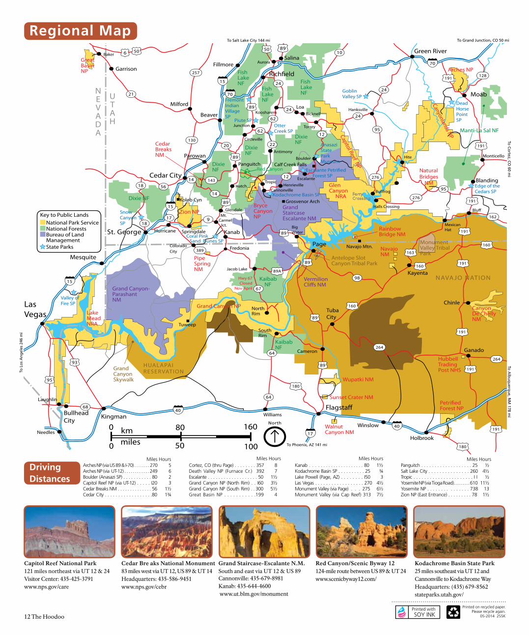
12 The Hoodoo
NEVADA
UTAH
ARIZONA
NEW
MEXICO
UTAH
COLORADO
89
89
Coral Pink Sand Dunes SP
St. George
Las Vegas
Cedar City
Rich�eld
NephiPrice
EphraimManti
Kanab
Page
Green River
Moab
Blanding
Monticello
TubaCity
Fredonia
ParowanPanguitch
Hurricane
Mesquite
Beaver
Fillmore
Gunnison
Salina
Blu�
Kayenta15
15
70
70
15
15
2424
24
12
24
89
89
89
89
89
89
89
191
191
191
191
191
191
191
95
95
491
163
160
160
160
89A
98
276
276
62
62
22
917
389
18
5618
67
14
14 143
20
28
6
6
10
10
128
160
12
130
257
Delta
Milford
Garrison
21
50
6
6
50
506
506
ColoradoCity
162
64
Mt. Carmel Jct.
Tropic
Cannonville
Escalante
Boulder
Torrey
Bicknell
LoaKoosharem
Antimony
Junction
Circleville
Hatch
Glendale
Springdale
Aurora
Scipio
Hanksville
Bullfrog
Halls Crossing
MexicanHat
Hite
Henrieville
BigWater
Cameron
Jacob Lake
NorthRim
SouthRim
Baker
132
Grand Jct.
Ganado
Chinle
191
191
264
26493
64
Shiprock
Gallup
Towaoc
Cortez
491
160
FerryCrossing
191
180
180
64
Flagsta�
Winslow
Holbrook
Kingman40
40
40
17
Williams
Grosvenor Arch
Calf Creek Falls
BullheadCity
Needles
95
Laughlin
68
50 1000
160800 kmmiles
Navajo Mtn.
Tuweep
Hwy 67Closed
Nov-April
Kolob Cyn
Zion NP
Grand Canyon NP
Glen Canyon NRA
LakeMeadNRA
Great BasinNP
CedarBreaksNM
Capitol Reef NP
BryceCanyonNP
Canyonlands NPArches NP
KaibabNF
GrandStaircase Escalante NM
DixieNF
FishLakeNF
Manti-La Sal NF
Manti- La SalNF
Grand Canyon-ParashantNM
NavajoNM
Manti- La SalNF
FishLakeNF
FishLakeNF
DixieNF
DixieNF
Dixie NF
Kaibab NF
VermilionCli�s NM
RainbowBridge NM
Monument Valley TribalPark
Antelope Slot Canyon Tribal Park
NaturalBridges NM
PipeSpringNM
Red Canyon
AnasaziState Park Museum
Escalante Petri�ed Forest SP
NAVA JO NATION
HOPI RESER VATION
Kodachrome Basin SP
GoblinValley SP
Edge of theCedars SP
CanyonDe ChellyNM
HubbellTrading Post NHS
HUALAPAIRESER VATION
HAVASUPAI
RESERVATION
FremontIndianVillageSP
MesaVerdeNP
UTE MOUNTAIN RESER VATION
Manti- La SalNF
DeadHorsePointSP
SnowCanyonSP
Petri�ed Forest NP
Walnut Canyon NM
Wupatki NM
Sunset Crater NM
Valley of Fire SP
GrandCanyonSkywalk
Otter Creek SP
Piute SP
North
National ForestsBureau of Land Management
National Park Service
Key to Public Lands
State Parks
Printed on recycled paper. Please recycle again.
05-2014 255K
Printed with SOY INK
Capitol Reef National Park121 miles northeast via UT 12 & 24Visitor Center: 435-425-3791 www.nps.gov/care
Cedar Bre aks National Monument 83 miles west via UT 12, US 89 & UT 14Headquarters: 435-586-9451 www.nps.gov/cebr
Grand Staircase-Escalante N.M.South and east via UT 12 & US 89 Cannonville: 435-679-8981 Kanab: 435-644-4600 www.ut.blm.gov/monument
Red Canyon/Scenic Byway 12124-mile route between US 89 & UT 24 www.scenicbyway12.com/