National Park Service U.S. Department of the Interior The Hoodoo BRYCE CANYON MAP & HIKING GUIDE Information & Services . . . . . . . 2 Accessibility . . . . . . . . . . . . . . . . . . 2 Safety . . . . . . . . . . . . . . . . . . . . 3 Weather . . . . . . . . . . . . . . . . . . 3 Backpacking . . . . . . . . . . . . . . . . 3 Park Map & Hiking Guide . . 4,5 Geology . . . . . . . . . . . . . . . . .6 Winter Activities . . . . . . . . . . 6 Natural History Association . . . . 7 Volunteers, Partners & Donors . . 7 Hoodoo You Love ........ 7 Regional Map . . . . . . . . . . . . . 8 Welcome to Bryce Canyon National Park! As a part of the larger Colorado Plateau, you are no doubt mesmerized by the kaleidoscope of rock layers and formations. In addition to the geologic features, the park’s fundamental resources and values include natural soundscapes, clean air and stellar night skies. Bryce is one of over 400 units of the national park system. Each unit preserves a unique slice, or story, of this nation’s natural and cultural heritage. During 2016, the National Park Service celebrates its 100th Anniversary. We wish to remain relevant in your lives and invite your families and friends to be the next generation of visitors, supporters and advocates. Thank you for supporting your national parks - we are glad you are here and we commit to facilitating a safe and enjoyable visit. Lisa E. Eckert Park Superintendent Visitor Center Stop at the Visitor Center for information, new exhibits, and a 22-minute award- winning orientation film. See Our Famous Overlooks Drive to Bryce, Inspiration, Sunset and Sunrise Points first. If you still have more time, visit overlooks in the southern portion of the park on our 18 Mile Scenic Drive. Short Walk Hike a short segment of the Rim Trail or select one of the other hikes from the “Easy to Moderate” group in the hiking table on page 5. Questions? Bring this newspaper to the Visitor Cen ter Desk! Short Walk and Day Hike(s) See the Hoodoos up close. Select one of the combination loops from the “Moderate” or “Strenuous” groups in the hiking table on page 5. Use caution as trails may be covered in snow and/ or ice. Check the weather first. Ranger Programs Attend a free Ranger Program to learn more about the natural and cultural history of this region. Rangers offer a limited number of programs in the fall, winter and spring. Inquire at the Visitor Center for a current schedule. Welcome! Have Less Than 4 Hours? Enjoy a Complete Day What’s Inside EMERGENCY INFORMATION PAGE 3 • Safety First! Make your visit to Bryce Canyon a safe one! Turn to page 3. • Water Refill Stations are available during the winter season at Sunset Point Restroom and the Visitor Center! Both indoor & outdoor units are available at the two locations mentioned above all hours including holidays. • Hoodoo You Love? Find out on page 7. • Celebrate the NPS Centennial with us! Ask about the Centennial newspaper. • Ask about our new Solar Array powering our Visitor Center building. Visitor Center Hours: October 4 – October 31, 2015 8 a.m. – 6 p.m. November 1, 2015 – April 2, 2016 8 a.m. – 4:30 p.m. April 3 - May 2, 2016 8 a.m. – 6 p.m. Fall - Winter - Spring Thor’s Hammer from the Navajo Loop Trail. Photo By Brian B. Roanhorse
Transcript
National Park Service
U.S. Department of the InteriorThe HoodooBryce canyon Map & Hiking guide
Welcome to Bryce Canyon National Park! As a part of the larger Colorado Plateau, you are no doubt mesmerized by the kaleidoscope of rock layers and formations. In addition to the geologic features, the park’s fundamental resources and values include natural soundscapes, clean air and stellar night skies.
Bryce is one of over 400 units of the national park system. Each unit preserves a unique slice, or story, of this nation’s natural and cultural heritage. During 2016, the National Park Service celebrates its 100th Anniversary. We wish to remain relevant in your lives and invite your families and friends to be the next generation of visitors, supporters and advocates. Thank you for supporting your national parks - we are glad you are here and we commit to facilitating a safe and enjoyable visit.
Lisa E. Eckert Park Superintendent
Visitor CenterStop at the Visitor Center for information, new exhibits, and a 22-minute award-winning orientation film.
See Our Famous Overlooks Drive to Bryce, Inspiration, Sunset and Sunrise Points first. If you still have more time, visit overlooks in the southern portion of the park on our 18 Mile Scenic Drive.
Short WalkHike a short segment of the Rim Trail or select one of the other hikes from the “Easy to Moderate” group in the hiking table on page 5.
Q u e s t i o n s ?Bring this
newspaper to theVisitor Center
Desk!
Short Walk and Day Hike(s)See the Hoodoos up close. Select one of the combination loops from the “Moderate” or “Strenuous” groups in the hiking table on page 5. Use caution as trails may be covered in snow and/or ice. Check the weather first.
Ranger ProgramsAttend a free Ranger Program to learn more about the natural and cultural history of this region. Rangers offer a limited number of programs in the fall, winter and spring. Inquire at the Visitor Center for a current schedule.
Welcome!
Have Less Than 4 Hours? Enjoy a Complete Day What’s Inside
EMERGENCY INFORMATION PAGE 3
• Safety First! Make your visit to Bryce Canyon a safe one! Turn to page 3.
• Water Refill Stations are available during the winter season at Sunset Point Restroom and the Visitor Center! Both indoor & outdoor units are available at the two locations mentioned above all hours including holidays.
• Hoodoo You Love? Find out on page 7.
• Celebrate the NPS Centennial with us! Ask about the Centennial newspaper.
• Ask about our new Solar Array powering our Visitor Center building.
V i s i t o r C e n t e r H o u r s : October 4 – October 31, 20158 a.m. – 6 p.m.
November 1, 2015 – April 2, 20168 a.m. – 4:30 p.m.
April 3 - May 2, 20168 a.m. – 6 p.m.
Fall - Winter - Spring
Thor’s Hammer from the Navajo Loop Trail. Photo By Brian B. Roanhorse
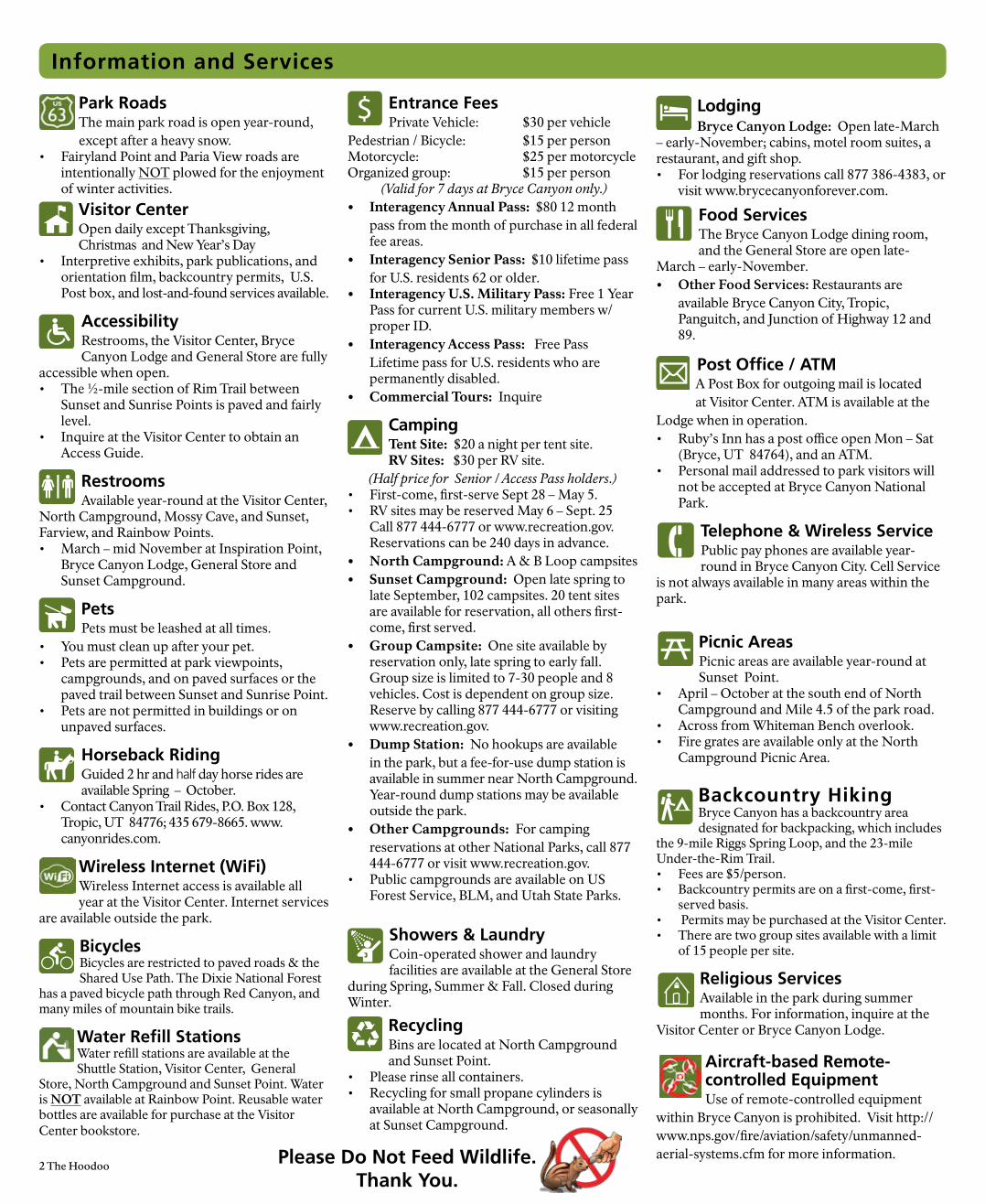
LodgingBryce Canyon Lodge: Open late-March
– early-November; cabins, motel room suites, a restaurant, and gift shop.• For lodging reservations call 877 386-4383, or
visit www.brycecanyonforever.com.
Food ServicesThe Bryce Canyon Lodge dining room, and the General Store are open late-
March – early-November. • Other Food Services: Restaurants are
available Bryce Canyon City, Tropic, Panguitch, and Junction of Highway 12 and 89.
Post Office / ATMA Post Box for outgoing mail is located at Visitor Center. ATM is available at the
Lodge when in operation.• Ruby’s Inn has a post office open Mon – Sat
(Bryce, UT 84764), and an ATM. • Personal mail addressed to park visitors will
not be accepted at Bryce Canyon National Park.
Telephone & Wireless ServicePublic pay phones are available year-round in Bryce Canyon City. Cell Service
is not always available in many areas within the park.
Picnic AreasPicnic areas are available year-round at Sunset Point.
• April – October at the south end of North Campground and Mile 4.5 of the park road.
• Across from Whiteman Bench overlook.• Fire grates are available only at the North
Campground Picnic Area.
Backcountry Hiking Bryce Canyon has a backcountry area designated for backpacking, which includes
the 9-mile Riggs Spring Loop, and the 23-mile Under-the-Rim Trail.• Fees are $5/person.• Backcountry permits are on a first-come, first-
served basis.• Permits may be purchased at the Visitor Center. • There are two group sites available with a limit
of 15 people per site.
Religious ServicesAvailable in the park during summer months. For information, inquire at the
Visitor Center or Bryce Canyon Lodge.
Aircraft-based Remote-controlled EquipmentUse of remote-controlled equipment
within Bryce Canyon is prohibited. Visit http://www.nps.gov/fire/aviation/safety/unmanned-aerial-systems.cfm for more information.
2 The Hoodoo
Park RoadsThe main park road is open year-round, except after a heavy snow.
• Fairyland Point and Paria View roads are intentionally NOT plowed for the enjoyment of winter activities.
Visitor Center Open daily except Thanksgiving, Christmas and New Year’s Day
• Interpretive exhibits, park publications, and orientation film, backcountry permits, U.S. Post box, and lost-and-found services available.
AccessibilityRestrooms, the Visitor Center, Bryce Canyon Lodge and General Store are fully
accessible when open. • The ½-mile section of Rim Trail between
Sunset and Sunrise Points is paved and fairly level.
• Inquire at the Visitor Center to obtain an Access Guide.
RestroomsAvailable year-round at the Visitor Center,
North Campground, Mossy Cave, and Sunset, Farview, and Rainbow Points. • March – mid November at Inspiration Point,
Bryce Canyon Lodge, General Store and Sunset Campground.
PetsPets must be leashed at all times.
• You must clean up after your pet.• Pets are permitted at park viewpoints,
campgrounds, and on paved surfaces or the paved trail between Sunset and Sunrise Point.
• Pets are not permitted in buildings or on unpaved surfaces.
Horseback RidingGuided 2 hr and half day horse rides are available Spring – October.
Wireless Internet (WiFi)Wireless Internet access is available all year at the Visitor Center. Internet services
are available outside the park.
BicyclesBicycles are restricted to paved roads & the Shared Use Path. The Dixie National Forest
has a paved bicycle path through Red Canyon, and many miles of mountain bike trails.
Water Refill StationsWater refill stations are available at the Shuttle Station, Visitor Center, General
Store, North Campground and Sunset Point. Water is NOT available at Rainbow Point. Reusable water bottles are available for purchase at the Visitor Center bookstore.
Information and Services
Entrance FeesPrivate Vehicle: $30 per vehicle
Pedestrian / Bicycle: $15 per personMotorcycle: $25 per motorcycleOrganized group: $15 per person
(Valid for 7 days at Bryce Canyon only.)• Interagency Annual Pass: $80 12 month
pass from the month of purchase in all federal fee areas.
• Interagency Senior Pass: $10 lifetime pass for U.S. residents 62 or older.
• Interagency U.S. Military Pass: Free 1 Year Pass for current U.S. military members w/ proper ID.
• Interagency Access Pass: Free Pass Lifetime pass for U.S. residents who are permanently disabled.
• Commercial Tours: Inquire
CampingTent Site: $20 a night per tent site.RV Sites: $30 per RV site.
(Half price for Senior / Access Pass holders.)• First-come, first-serve Sept 28 – May 5. • RV sites may be reserved May 6 – Sept. 25
Call 877 444-6777 or www.recreation.gov. Reservations can be 240 days in advance.
• North Campground: A & B Loop campsites • Sunset Campground: Open late spring to
late September, 102 campsites. 20 tent sites are available for reservation, all others first-come, first served.
• Group Campsite: One site available by reservation only, late spring to early fall. Group size is limited to 7-30 people and 8 vehicles. Cost is dependent on group size. Reserve by calling 877 444-6777 or visiting www.recreation.gov.
• Dump Station: No hookups are available in the park, but a fee-for-use dump station is available in summer near North Campground. Year-round dump stations may be available outside the park.
• Other Campgrounds: For camping reservations at other National Parks, call 877 444-6777 or visit www.recreation.gov.
• Public campgrounds are available on US Forest Service, BLM, and Utah State Parks.
Showers & LaundryCoin-operated shower and laundry facilities are available at the General Store
during Spring, Summer & Fall. Closed during Winter.
Recycling Bins are located at North Campground and Sunset Point.
• Please rinse all containers. • Recycling for small propane cylinders is
available at North Campground, or seasonally at Sunset Campground.
Please Do Not Feed Wildlife.
Thank You.
The Hoodoo 3
National Park Service U.S. Department of the InteriorEmergencies Call 911 or 435-676-2411
Park Headquarters435 834-5322Fax 435 834-4703Lost & Found: 435 834-4736
Travelers Information Stations: Tune radio to 1590 and 1610 AM for park and shuttle information
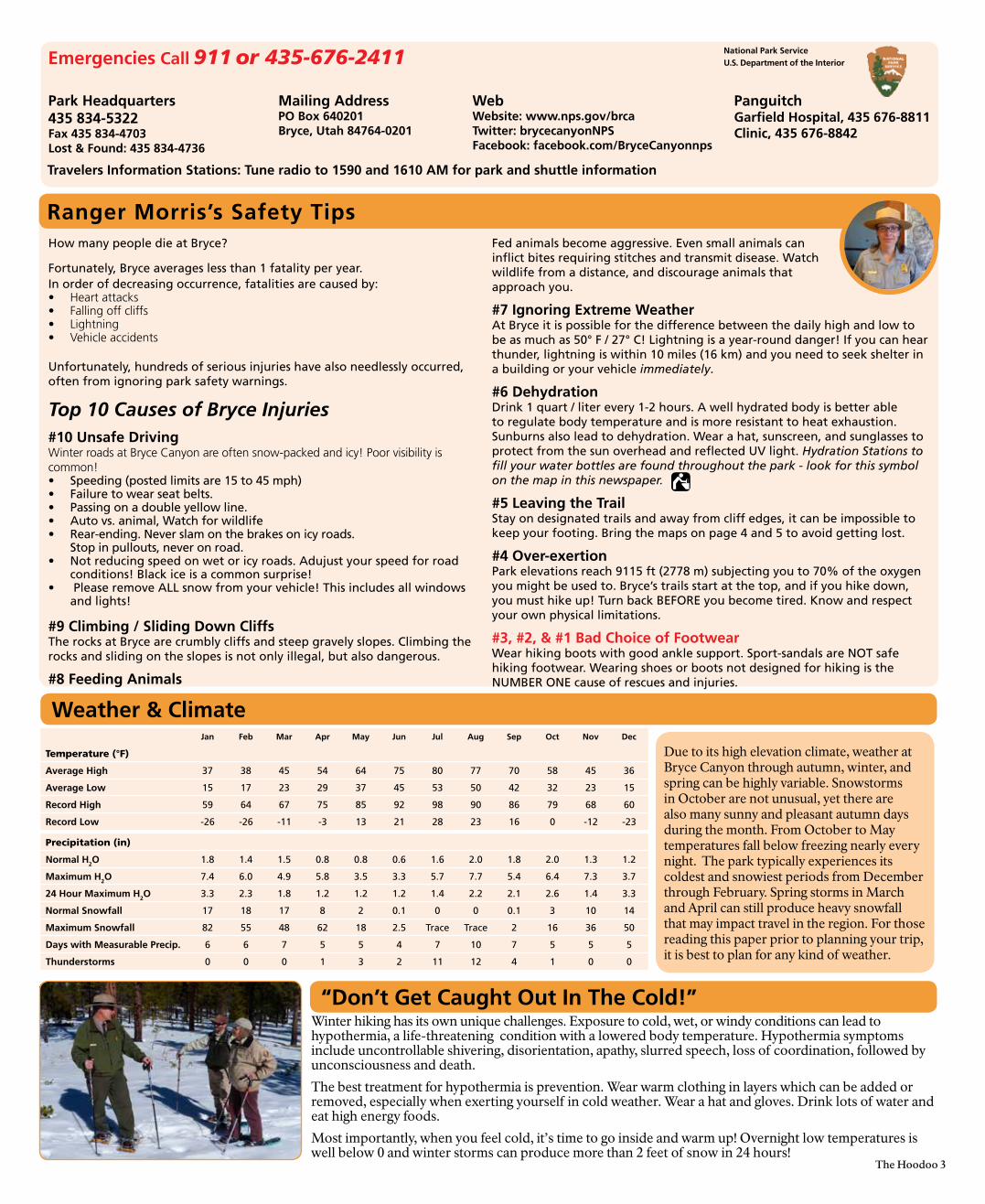
How many people die at Bryce?
Fortunately, Bryce averages less than 1 fatality per year. In order of decreasing occurrence, fatalities are caused by:• Heart attacks• Falling off cliffs• Lightning• Vehicle accidents
Unfortunately, hundreds of serious injuries have also needlessly occurred, often from ignoring park safety warnings.
Top 10 Causes of Bryce Injuries#10 Unsafe DrivingWinter roads at Bryce Canyon are often snow-packed and icy! Poor visibility is common!• Speeding (posted limits are 15 to 45 mph)• Failure to wear seat belts.• Passing on a double yellow line.• Auto vs. animal, Watch for wildlife• Rear-ending. Never slam on the brakes on icy roads.
Stop in pullouts, never on road.• Not reducing speed on wet or icy roads. Adujust your speed for road
conditions! Black ice is a common surprise!• Please remove ALL snow from your vehicle! This includes all windows
and lights!
#9 Climbing / Sliding Down CliffsThe rocks at Bryce are crumbly cliffs and steep gravely slopes. Climbing the rocks and sliding on the slopes is not only illegal, but also dangerous.
#8 Feeding Animals
Fed animals become aggressive. Even small animals can inflict bites requiring stitches and transmit disease. Watch wildlife from a distance, and discourage animals that approach you.
#7 Ignoring Extreme WeatherAt Bryce it is possible for the difference between the daily high and low to be as much as 50° F / 27° C! Lightning is a year-round danger! If you can hear thunder, lightning is within 10 miles (16 km) and you need to seek shelter in a building or your vehicle immediately. #6 Dehydration Drink 1 quart / liter every 1-2 hours. A well hydrated body is better able to regulate body temperature and is more resistant to heat exhaustion. Sunburns also lead to dehydration. Wear a hat, sunscreen, and sunglasses to protect from the sun overhead and reflected UV light. Hydration Stations to fill your water bottles are found throughout the park - look for this symbol on the map in this newspaper.
#5 Leaving the Trail Stay on designated trails and away from cliff edges, it can be impossible to keep your footing. Bring the maps on page 4 and 5 to avoid getting lost.
#4 Over-exertion Park elevations reach 9115 ft (2778 m) subjecting you to 70% of the oxygen you might be used to. Bryce’s trails start at the top, and if you hike down, you must hike up! Turn back BEFORE you become tired. Know and respect your own physical limitations.
#3, #2, & #1 Bad Choice of Footwear Wear hiking boots with good ankle support. Sport-sandals are NOT safe hiking footwear. Wearing shoes or boots not designed for hiking is the NUMBER ONE cause of rescues and injuries.
Days with Measurable Precip. 6 6 7 5 5 4 7 10 7 5 5 5
Thunderstorms 0 0 0 1 3 2 11 12 4 1 0 0
Weather & Climate
Winter hiking has its own unique challenges. Exposure to cold, wet, or windy conditions can lead to hypothermia, a life-threatening condition with a lowered body temperature. Hypothermia symptoms include uncontrollable shivering, disorientation, apathy, slurred speech, loss of coordination, followed by unconsciousness and death.
The best treatment for hypothermia is prevention. Wear warm clothing in layers which can be added or removed, especially when exerting yourself in cold weather. Wear a hat and gloves. Drink lots of water and eat high energy foods.
Most importantly, when you feel cold, it’s time to go inside and warm up! Overnight low temperatures is well below 0 and winter storms can produce more than 2 feet of snow in 24 hours!
“Don’t Get Caught Out In The Cold!”
Due to its high elevation climate, weather at Bryce Canyon through autumn, winter, and spring can be highly variable. Snowstorms in October are not unusual, yet there are also many sunny and pleasant autumn days during the month. From October to May temperatures fall below freezing nearly every night. The park typically experiences its coldest and snowiest periods from December through February. Spring storms in March and April can still produce heavy snowfall that may impact travel in the region. For those reading this paper prior to planning your trip, it is best to plan for any kind of weather.
4 The Hoodoo
X XXX
X X X X
3.5
mi (
5 .6
km)
P ari
a Sk
i Lo
op
Old
Bry
ce
Tow
nSk
i Lo
op
I.5 mi (2.4 km)
0.7 mi (I.I km)
Dav
es
Ho
llow
Ski L
oo
ps I.3
mi (2.2 km)
I.8 m
i (2.
9 km
)
I.4 mi (2
.3 km)
0.8
mi (
I.3 km)
0.9
mi (
I.4 k
m)
0.4
mi (
0.6
km)
0.9 mi (I.4
km)
0.5 mi (0.8 km)
Rim
Ski L
oo
p
Pari
aV
iew
Insp
ira
tio
n
P
oin
t
2 m
i3
kmI mi
2 km
I m
i2
km
Fair
ylan
d P
oin
t
No
rth
Cam
pg
rou
nd
Fair
ylan
dLo
op
Un
der
the
Rim
Trai
l
Trai
ler
Dro
p-o
ff
63
Trai
ler
Turn
Aro
un
dN
o t
raile
rs p
erm
itte
d a
t
B
ryce
Po
int
or
Pari
a V
iew
Bry
ceP
oin
t
Sin
kin
gSh
ip74
05 ft
2257
m
Tow
erB
rid
ge
Rim
Tra
il
Rim Tr
ail
2 m
i 3
km
7758
ft23
65m
7894
ft24
06m
6821
ft20
79m
833I
ft25
39m
BO
AT
ME S A
Trop
ic D
itch
Cam
pb
ell W
ash
Bryc
e Cr
eek
Bri
stle
con
ePo
int Hat
Sh
op
Co
rral
Hig
h P
late
aus
Inst
itu
te
Ho
rse
Trai
l(h
ors
e o
nly
)
Pe
ekab
oo
Lo
op
(hor
se &
hik
er)
2.5
mi (
4.0
km)
4.
0 mi (6.4
km
)
I.5 mi (2
.4 k
m)
0.6
mi (
I.0 k
m)
I.8 m
i (2.
9 km
)
I.5 m
i (2.
4 km
)
0.7 mi ( I.2 km)
0.5mi (0.8km)
I.I m
i ( I.
8 k m
)
2.0 m
i (3.
8 km
)
0.9
mi (
I.4k
m)
0.8 mi (I.3 km)
QU
EEN
VIC
TOR
IA
Qu
een
sG
ard
en T
rail
I.3
mi (
2.I km)
I.7 m
i ( 2 .7 km
)
Nav
ajo
Loo
p
CA
MPB
ELL CA
NY
ON
FA
I RY
LA
ND
CA
NY
ON 72
00 ft
2I95
m
7787
ft23
73m
To R
ain
bo
w P
oin
tI 3
mi
20 k
m
Entr
ance
Sig
n
To Tro
pic
5 m
i8
km
I2
0.4
mi (
0.6 km)
Ho
rse
Trai
l(h
ors
e o
nly
)
2 m
i3
km
BR
YC
E A
MPH
ITH
EATE
R0.
7 m
i (I.I
km
)
THO
RS
HA
MM
ER
WA
LLST
REE
T
(ro
ad n
ot
plo
wed
in w
inte
r)
(ro
ad n
ot
plo
wed
in w
inte
r)
Su
nri
se P
oin
t
Po
int
Su
nse
t
KPOE
No
rth
0
I
Mile
I Kilo
met
er0.
5
0.5
0
Mo
ssy
Cav
e
Sun
set
Poin
t
Vis
ito
r C
ente
r
Gat
e cl
ose
d d
uri
ng
sno
w s
torm
s
Bry
ce C
anyo
n L
od
ge
(clo
sed
mid
-No
v th
ru M
ar)
Gen
eral
Sto
re(c
lose
d m
id-N
ov
thru
Mar
)
Sun
set
Cam
pg
rou
nd
(clo
sed
Oct
- A
pr)
Bri
stle
con
eLo
op
Tra
il
Rig
gs
Spri
ng
Loo
pTr
ail
9 I I
5 ft
2778
m
Ag
ua
Can
yon
Nat
ura
lB
rid
ge
Pira
cyPo
int
Pari
aV
iewIn
spir
atio
n P
oin
t
Sun
rise
Po
int
Sun
set
Bry
ceC
anyo
nA
irp
ort
3 m
i5
km
2 m
i 3
km
2 m
i3
kmI mi
2 km
I m
i2
km
3 m
i5
kmTo A
nti
mo
ny
34 m
i55
km
Fair
ylan
d P
oin
t
No
rth
Swam
pC
anyo
nLo
op
Fair
ylan
dLo
op
4 m
i6
km
Kin
gC
reek
3 m
i5
km
9 m
iI4
km
Un
der
the
Rim
Trai
l
Un
der
the
Rim
Trai
l
Un
der
the
Rim
Trai
l
63
I2
Pa
ria R
iver
Tro
pic
Ditc
h
Tro
pic
Res
ervi
or
Bla
ckB
irch
Can
yon
I2
3 m
i5
km
7998
ft24
38 m
7200
ft 2
I95
m
Tro
pic
88I9
ft 2
688
m
833I
ft25
39 m
Shee
p C
reek
Will
is C
reek
Eas
t For
k Se
vier
River
East Fork Sevier River
East Fork Sevier River
6360
ft I
938
m
Tropic Ditch
Bryc
e Cr
eek
7 m
iI I
km
Bu
ll V
alle
y G
org
e
Yello
w C
reek
To I I m
iI8
km
89 087
To C
anno
nvill
e5 m
i
8 km
Bryc
e Po
int
Swam
pC
anyo
n
Wh
item
anB
ench Po
nd
ero
saC
anyo
n
22
Sin
kin
gSh
ip74
05 ft
2257
m
7480
ft22
57 m
Tow
erB
rid
ge
7855
ft23
94 m
Ho
rse
Mo
un
tain
7563
ft23
05 m
Shak
esp
ear
Poin
t78
42 ft
2390
m
DIX
IE N
ATI
ON
AL
FOR
EST
DIXIE NATIONAL FOREST
DIXIE NATIONAL FOREST
DIX
IE N
ATI
ON
AL
FOR
EST
GRAND STAIRCASE - ESCALANTE
NATIONAL MONUMENT
GR
AN
D S
TAIR
CA
SE-E
SCA
LAN
TE
N
ATI
ON
AL
MO
NU
MEN
T
GR
AN
D S
TAIR
CA
SE-E
SCA
LAN
TE
N
ATI
ON
AL
MO
NU
MEN
T
PAUNSAUGUNT PLATEAU
DIX
IE N
ATI
ON
AL
FOR
EST
DIX
IE N
ATI
ON
AL
FOR
EST
Rim
Tra
il
Rim Tr
ail
Ag
ua
Can
yon
Co
nn
ecti
ng
Tr
ail
Wh
item
anB
ench
Co
nn
ecti
ng
Tr
ail
No
tra
ilers
per
mit
ted
at
Bry
cePo
int
or
Pari
a V
iew
No
rth
0 0I M
ile
I Kilo
met
er0.
5
0.5
Bry
ce A
mp
hit
hea
ter
Reg
ion
Sun
set
Poin
tB
ryce
Can
yon
Lo
dg
e(c
lose
d m
id-N
ov
thru
Mar
)
Gen
eral
Sto
re(c
lose
d m
id-N
ov
thru
Mar
)
Vis
ito
r C
ente
r
Mo
ssy
Cav
e
Gat
e cl
ose
d d
uri
ng
win
ter
sto
rms
Rai
nb
ow
&Yo
vim
pa
Poin
ts
Farv
iew
Po
int
(clo
sed
in w
inte
r)
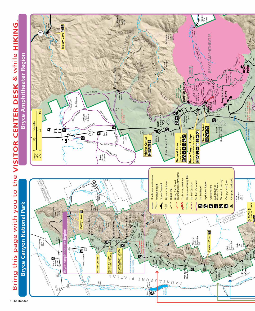
Bri
ng
th
is p
ag
e w
ith
yo
u t
o t
he
VIS
ITO
R C
EN
TE
R D
ES
K &
wh
ile
HIK
ING
.B
ryce
Am
ph
ith
eate
r R
egio
nB
ryce
Can
yon
Nat
ion
al P
ark
Cam
psite
(bac
kpac
k)
Dis
tanc
e In
dica
tor
3 m
i5
km
Hik
ing
Trai
l Clo
sed
Dur
ing
Incl
emen
t Wea
ther
Hik
ing
Trai
l
Cam
pgro
und
(car
)
Show
ers
& L
aund
ry
Aud
itoriu
m o
r O
utdo
or T
heat
er
Gro
cery
Sto
re
Unp
aved
Roa
d
Scen
ic O
verlo
ok
Hor
se a
nd/o
r Hik
ing
Trai
l
Road
(not
plo
wed
in w
inte
r)
Ski T
rail
(2-t
rack
)
Ski T
rail
(Gro
omed
)
Ski T
railh
ead
Trai
l clo
sed
in w
inte
r X
XX
XX
X
Hyd
ratio
n St
atio
n
The Hoodoo 5
X XXX
X X X X
3.5
mi (
5 .6
km)
P ari
a Sk
i Lo
op
Old
Bry
ce
Tow
nSk
i Lo
op
I.5 mi (2.4 km)
0.7 mi (I.I km)
Dav
es
Ho
llow
Ski L
oo
ps I.3
mi (2.2 km)
I.8 m
i (2.
9 km
)
I.4 mi (2
.3 km)
0.8
mi (
I.3 km)
0.9
mi (
I.4 k
m)
0.4
mi (
0.6
km)
0.9 mi (I.4
km)
0.5 mi (0.8 km)
Rim
Ski L
oo
p
Pari
aV
iew
Insp
ira
tio
n
P
oin
t
2 m
i3
kmI mi
2 km
I m
i2
km
Fair
ylan
d P
oin
t
No
rth
Cam
pg
rou
nd
Fair
ylan
dLo
op
Un
der
the
Rim
Trai
l
Trai
ler
Dro
p-o
ff
63
Trai
ler
Turn
Aro
un
dN
o t
raile
rs p
erm
itte
d a
t
B
ryce
Po
int
or
Pari
a V
iew
Bry
ceP
oin
t
Sin
kin
gSh
ip74
05 ft
2257
m
Tow
erB
rid
ge
Rim
Tra
il
Rim Tr
ail
2 m
i 3
km
7758
ft23
65m
7894
ft24
06m
6821
ft20
79m
833I
ft25
39m
BO
AT
ME S A
Trop
ic D
itch
Cam
pb
ell W
ash
Bryc
e Cr
eek
Bri
stle
con
ePo
int Hat
Sh
op
Co
rral
Hig
h P
late
aus
Inst
itu
te
Ho
rse
Trai
l(h
ors
e o
nly
)
Pe
ekab
oo
Lo
op
(hor
se &
hik
er)
2.5
mi (
4.0
km)
4.
0 mi (6.4
km
)
I.5 mi (2
.4 k
m)
0.6
mi (
I.0 k
m)
I.8 m
i (2.
9 km
)
I.5 m
i (2.
4 km
)
0.7 mi ( I.2 km)
0.5mi (0.8km)
I.I m
i ( I.
8 k m
)
2.0 m
i (3.
8 km
)
0.9
mi (
I.4k
m)
0.8 mi (I.3 km)
QU
EEN
VIC
TOR
IA
Qu
een
sG
ard
en T
rail
I.3
mi (
2.I km)
I.7 m
i ( 2 .7 km
)
Nav
ajo
Loo
p
CA
MPB
ELL CA
NY
ON
FA
I RY
LA
ND
CA
NY
ON 72
00 ft
2I95
m
7787
ft23
73m
To R
ain
bo
w P
oin
tI 3
mi
20 k
m
Entr
ance
Sig
n
To Tro
pic
5 m
i8
km
I2
0.4
mi (
0.6 km)
Ho
rse
Trai
l(h
ors
e o
nly
)
2 m
i3
km
BR
YC
E A
MPH
ITH
EATE
R0.
7 m
i (I.I
km
)
THO
RS
HA
MM
ER
WA
LLST
REE
T
(ro
ad n
ot
plo
wed
in w
inte
r)
(ro
ad n
ot
plo
wed
in w
inte
r)
Su
nri
se P
oin
t
Po
int
Su
nse
t
KPOE
No
rth
0
I
Mile
I Kilo
met
er0.
5
0.5
0
Mo
ssy
Cav
e
Sun
set
Poin
t
Vis
ito
r C
ente
r
Gat
e cl
ose
d d
uri
ng
sno
w s
torm
s
Bry
ce C
anyo
n L
od
ge
(clo
sed
mid
-No
v th
ru M
ar)
Gen
eral
Sto
re(c
lose
d m
id-N
ov
thru
Mar
)
Sun
set
Cam
pg
rou
nd
(clo
sed
Oct
- A
pr)
Bri
stle
con
eLo
op
Tra
il
Rig
gs
Spri
ng
Loo
pTr
ail
9 I I
5 ft
2778
m
Ag
ua
Can
yon
Nat
ura
lB
rid
ge
Pira
cyPo
int
Pari
aV
iewIn
spir
atio
n P
oin
t
Sun
rise
Po
int
Sun
set
Bry
ceC
anyo
nA
irp
ort
3 m
i5
km
2 m
i 3
km
2 m
i3
kmI mi
2 km
I m
i2
km
3 m
i5
kmTo A
nti
mo
ny
34 m
i55
km
Fair
ylan
d P
oin
t
No
rth
Swam
pC
anyo
nLo
op
Fair
ylan
dLo
op
4 m
i6
km
Kin
gC
reek
3 m
i5
km
9 m
iI4
km
Un
der
the
Rim
Trai
l
Un
der
the
Rim
Trai
l
Un
der
the
Rim
Trai
l
63
I2
Pa
ria R
iver
Tro
pic
Ditc
h
Tro
pic
Res
ervi
or
Bla
ckB
irch
Can
yon
I2
3 m
i5
km
7998
ft24
38 m
7200
ft 2
I95
m
Tro
pic
88I9
ft 2
688
m
833I
ft25
39 m
Shee
p C
reek
Will
is C
reek
Eas
t For
k Se
vier
River
East Fork Sevier River
East Fork Sevier River
6360
ft I
938
m
Tropic Ditch
Bryc
e Cr
eek
7 m
iI I
km
Bu
ll V
alle
y G
org
e
Yello
w C
reek
To I I m
iI8
km
89 087
To C
anno
nvill
e5 m
i
8 km
Bryc
e Po
int
Swam
pC
anyo
n
Wh
item
anB
ench Po
nd
ero
saC
anyo
n
22
Sin
kin
gSh
ip74
05 ft
2257
m
7480
ft22
57 m
Tow
erB
rid
ge
7855
ft23
94 m
Ho
rse
Mo
un
tain
7563
ft23
05 m
Shak
esp
ear
Poin
t78
42 ft
2390
m
DIX
IE N
ATI
ON
AL
FOR
EST
DIXIE NATIONAL FOREST
DIXIE NATIONAL FOREST
DIX
IE N
ATI
ON
AL
FOR
EST
GRAND STAIRCASE - ESCALANTE
NATIONAL MONUMENT
GR
AN
D S
TAIR
CA
SE-E
SCA
LAN
TE
N
ATI
ON
AL
MO
NU
MEN
T
GR
AN
D S
TAIR
CA
SE-E
SCA
LAN
TE
N
ATI
ON
AL
MO
NU
MEN
T
PAUNSAUGUNT PLATEAU
DIX
IE N
ATI
ON
AL
FOR
EST
DIX
IE N
ATI
ON
AL
FOR
EST
Rim
Tra
il
Rim Tr
ail
Ag
ua
Can
yon
Co
nn
ecti
ng
Tr
ail
Wh
item
anB
ench
Co
nn
ecti
ng
Tr
ail
No
tra
ilers
per
mit
ted
at
Bry
cePo
int
or
Pari
a V
iew
No
rth
0 0I M
ile
I Kilo
met
er0.
5
0.5
Bry
ce A
mp
hit
hea
ter
Reg
ion
Sun
set
Poin
tB
ryce
Can
yon
Lo
dg
e(c
lose
d m
id-N
ov
thru
Mar
)
Gen
eral
Sto
re(c
lose
d m
id-N
ov
thru
Mar
)
Vis
ito
r C
ente
r
Mo
ssy
Cav
e
Gat
e cl
ose
d d
uri
ng
win
ter
sto
rms
Rai
nb
ow
&Yo
vim
pa
Poin
ts
Farv
iew
Po
int
(clo
sed
in w
inte
r)
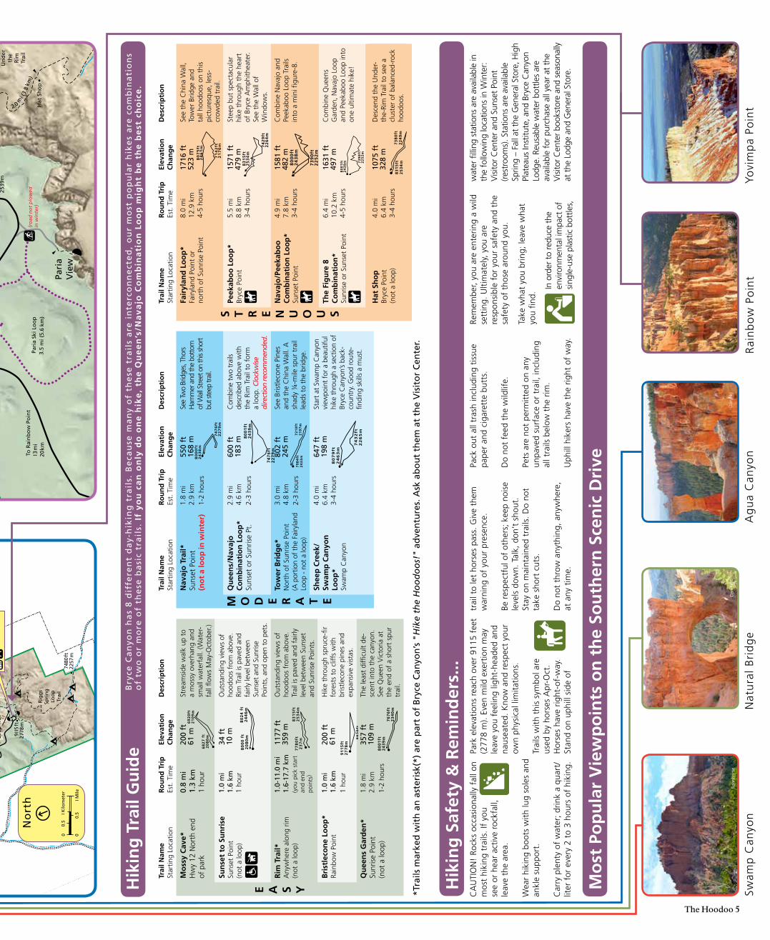
Hik
ing
Tra
il G
uid
eB
ryce
Ca
nyo
n h
as
8 d
iffe
ren
t d
ay-
hik
ing
tra
ils.
Be
cau
se m
an
y o
f th
ese
tra
ils
are
in
terc
on
ne
cte
d,
ou
r m
ost
po
pu
lar
hik
es
are
co
mb
ina
tio
ns
of
two
or
mo
re o
f th
ese
ba
sic
tra
ils.
If
yo
u c
an
on
ly d
o o
ne
hik
e,
the
Qu
ee
n’s
/Na
va
jo C
om
bin
ati
on
Lo
op
mig
ht
be
th
e b
est
ch
oic
e.
Hik
ing
Saf
ety
& R
emin
der
s...
*Tra
ils m
arke
d w
ith
an
ast
eris
k(*)
are
par
t o
f B
ryce
Can
yon
’s "
Hik
e th
e H
oo
do
os!
" ad
ven
ture
s. A
sk a
bo
ut
them
at
the
Vis
ito
r C
ente
r.
Mo
st P
op
ula
r V
iew
po
ints
on
th
e So
uth
ern
Sce
nic
Dri
ve
Nat
ura
l B
rid
ge
Dan
Ng
Swam
p C
anyo
n
Roan
hors
eRo
n W
arne
r
Rai
nb
ow
Po
int
Dan
Ng
Yovi
mp
a Po
int
Dan
Ng
Ag
ua
Can
yon
CA
UTI
ON
! Ro
cks
occa
sion
ally
fal
l on
mos
t hi
king
tra
ils. I
f yo
u se
e or
hea
r ac
tive
rock
fall,
leav
e th
e ar
ea.
Wea
r hi
king
boo
ts w
ith lu
g so
les
and
ankl
e su
ppor
t.
Car
ry p
lent
y of
wat
er; d
rink
a qu
art/
liter
for
eve
ry 2
to
3 ho
urs
of h
ikin
g.
Park
ele
vatio
ns r
each
ove
r 91
15 f
eet
(277
8 m
). Ev
en m
ild e
xert
ion
may
le
ave
you
feel
ing
light
-hea
ded
and
naus
eate
d. K
now
and
res
pect
you
r ow
n ph
ysic
al li
mita
tions
.
Trai
ls w
ith t
his
sym
bol a
re
used
by
hors
es A
pr-O
ct.
Hor
ses
have
rig
ht-o
f-w
ay.
Stan
d on
uph
ill s
ide
of
trai
l to
let
hors
es p
ass.
Giv
e th
em
war
ning
of
your
pre
senc
e.
Be r
espe
ctfu
l of
othe
rs; k
eep
nois
e le
vels
dow
n. T
alk,
don
’t s
hout
.St
ay o
n m
aint
aine
d tr
ails
. Do
not
take
sho
rt c
uts.
Do
not
thro
w a
nyth
ing,
any
whe
re,
at a
ny t
ime.
Pack
out
all
tras
h in
clud
ing
tissu
e pa
per
and
ciga
rett
e bu
tts.
Do
not
feed
the
wild
life.
Pets
are
not
per
mitt
ed o
n an
y un
pave
d su
rfac
e or
tra
il, in
clud
ing
al
l tra
ils b
elow
the
rim
.
Uph
ill h
iker
s ha
ve t
he r
ight
of
way
.
Rem
embe
r, yo
u ar
e en
terin
g a
wild
se
ttin
g. U
ltim
atel
y, y
ou a
rere
spon
sibl
e fo
r yo
ur s
afet
y an
d th
e sa
fety
of
thos
e ar
ound
you
.
Take
wha
t yo
u br
ing;
leav
e w
hat
yo
u fin
d.
In o
rder
to
redu
ce t
he
envi
ronm
enta
l im
pact
of
sing
le-u
se p
last
ic b
ottle
s,
wat
er fi
lling
sta
tions
are
ava
ilabl
e in
th
e fo
llow
ing
loca
tions
in W
inte
r:
Vis
itor
Cen
ter
and
Suns
et P
oint
(re
stro
oms)
. Sta
tions
are
ava
ilabl
e Sp
ring
– Fa
ll at
the
Gen
eral
Sto
re, H
igh
Plat
eaus
Inst
itute
, and
Bry
ce C
anyo
n Lo
dge.
Reu
sabl
e w
ater
bot
tles
are
avai
labl
e fo
r pu
rcha
se a
ll ye
ar a
t th
e V
isito
r Cen
ter b
ooks
tore
and
sea
sona
lly
at t
he L
odge
and
Gen
eral
Sto
re.
Trai
l Nam
e St
artin
g Lo
catio
nR
ou
nd
Tri
p
Est.
Tim
eEl
evat
ion
C
han
ge
Des
crip
tio
n
Mo
ssy
Cav
e*
Hw
y 12
Nor
th e
nd
of p
ark
0.8
mi
1.3
km
1 ho
ur
200
ft
61 m
Stre
amsi
de w
alk
up t
o a
mos
sy o
verh
ang
and
smal
l wat
erfa
ll. (W
ater
-fa
ll flo
ws
May
-Oct
ober
.)
Sun
set
to S
un
rise
Su
nset
Poi
nt
(not
a lo
op)
1.0
mi
1.6
km1
hour
34 f
t 10
mO
utst
andi
ng v
iew
s of
ho
odoo
s fr
om a
bove
. Ri
m T
rail
is p
aved
and
fa
irly
leve
l bet
wee
n Su
nset
and
Sun
rise
Poin
ts, a
nd o
pen
to p
ets.
Rim
Tra
il*
Any
whe
re a
long
rim
(n
ot a
loop
)
1.0-
11.0
mi
1.6-
17.7
km
(you
pic
k st
art
and
end
poin
ts)
1177
ft
359
mO
utst
andi
ng v
iew
s of
ho
odoo
s fr
om a
bove
. Tr
ail i
s pa
ved
and
fairl
y le
vel b
etw
een
Suns
et
and
Sunr
ise
Poin
ts.
Bri
stle
con
e Lo
op
* Ra
inbo
w P
oint
1.0
mi
1.6
km1
hour
200
ft
61 m
Hik
e th
roug
h sp
ruce
-fir
fore
sts
to c
liffs
with
br
istle
cone
pin
es a
nd
expa
nsiv
e vi
stas
.
Qu
een
s G
ard
en*
Sunr
ise
Poin
t (n
ot a
loop
)
1.8
mi
2.9
km1-
2 ho
urs
357
ft
109
mTh
e le
ast
diffi
cult
de-
scen
t in
to t
he c
anyo
n.
See
Que
en V
icto
ria a
t th
e en
d of
a s
hort
spu
r tr
ail.
E A S Y
80
00
ft
20
80
m8
02
4 f
t2
44
6m
77
80
ft2
37
m
83
15
ft2
53
4m
91
15
ft2
77
8m
89
39
ft2
72
5m
80
01
ft2
43
9m
76
76
ft2
34
0m
Trai
l Nam
e St
artin
g Lo
catio
nR
ou
nd
Tri
p
Est.
Tim
eEl
evat
ion
C
han
ge
Des
crip
tio
n
Nav
ajo
Tra
il*
Suns
et P
oint
(no
t a
loo
p in
win
ter)
1.8
mi
2.9
km1-
2 ho
urs
550
ft
168
mSe
e Tw
o Br
idge
s, Th
ors
Ham
mer
and
the
botto
m
of W
all S
treet
on
this
shor
t bu
t ste
ep tr
ail.
Qu
een
s/N
avaj
o
Co
mb
inat
ion
Lo
op
* Su
nset
or
Sunr
ise
Pt.
2.9
mi
4.6
km2-
3 ho
urs
600
ft
183
mC
ombi
ne tw
o tr
ails
de
scrib
ed a
bove
with
th
e Ri
m T
rail
to f
orm
a
loop
. Clo
ckw
ise
dire
ctio
n re
com
men
ded.
Tow
er B
rid
ge*
N
orth
of
Sunr
ise
Poin
t(A
por
tion
of t
he F
airy
land
Lo
op -
not
a lo
op)
3.0
mi
4.8
km2-
3 ho
urs
802
ft
245
mSe
e Br
istle
cone
Pin
es
and
the
Chi
na W
all.
A
shad
y ¼
-mile
spu
r tr
ail
lead
s to
the
brid
ge.
Shee
p C
reek
/Sw
amp
Can
yon
Lo
op
* Sw
amp
Can
yon
4.0
mi
6.4
km3-
4 ho
urs
647
ft
198
mSt
art
at S
wam
p C
anyo
n vi
ewpo
int
for
a be
autif
ul
hike
thr
ough
a s
ectio
n of
Br
yce
Can
yon’
s ba
ck-
coun
try.
Goo
d ro
ute-
findi
ng s
kills
a m
ust.
M O D E R A T E
80
00
ft2
43
8m
74
76
ft2
27
9m
80
01
ft2
43
9m
74
76
ft2
27
9m
79
84
ft2
43
3m
72
10
ft2
19
7m
80
79
ft2
46
3m
74
32
ft2
26
5m
Trai
l Nam
e St
artin
g Lo
catio
nR
ou
nd
Tri
p
Est.
Tim
eEl
evat
ion
C
han
ge
Des
crip
tio
n
Fair
ylan
d L
oo
p*
Fairy
land
Poi
nt o
r no
rth
of S
unris
e Po
int
8.0
mi
12.9
km
4-5
hour
s
1716
ft
523
mSe
e th
e C
hina
Wal
l, To
wer
Brid
ge a
nd
tall
hood
oos
on t
his
pict
ures
que,
less
-cr
owde
d tr
ail.
Peek
abo
o L
oo
p*
Bryc
e Po
int
5.5
mi
8.8
km3-
4 ho
urs
1571
ft
479
mSt
eep
but
spec
tacu
lar
hike
thr
ough
the
hea
rt
of B
ryce
Am
phith
eate
r. Se
e th
e W
all o
f W
indo
ws.
Nav
ajo
/Pee
kab
oo
C
om
bin
atio
n L
oo
p*
Suns
et P
oint
4.9
mi
7.8
km3-
4 ho
urs
1581
ft
482
mC
ombi
ne N
avaj
o an
d Pe
ekab
oo L
oop
Trai
ls
into
a m
ini fi
gure
-8.
The
Fig
ure
8
Co
mb
inat
ion
* Su
nris
e or
Sun
set
Poin
t
6.4
mi
10.2
km
4-5
hour
s
1631
ft
497
mC
ombi
ne Q
ueen
s G
arde
n, N
avaj
o Lo
op
and
Peek
aboo
Loo
p in
to
one
ultim
ate
hike
!
S T R E N U O U S8
00
1ft
24
39
m 73
90
ft2
25
2m
80
75
ft2
46
1m
71
42
ft2
17
6m
83
15
ft2
53
4m
74
29
ft2
26
4m
80
00
ft2
43
8m
73
90
ft2
25
2m
68
27
ft
20
80
m
69
20
ft2
10
9m
Hat
Sh
op
Br
yce
Poin
t(n
ot a
loop
)
4.0
mi
6.4
km3-
4 ho
urs
1075
ft
328
mD
esce
nd t
he U
nder
-th
e-Ri
m T
rail
to s
ee a
cl
uste
r of
bal
ance
d-ro
ck
hood
oos.
83
15
ft2
53
4m
73
80
ft2
24
9m
6 The HoodooIn winter the fur of two mammal species at Bryce Canyon changes from brown to white: Long-tailed Weasels (above) and White-tailed Jackrabbits.
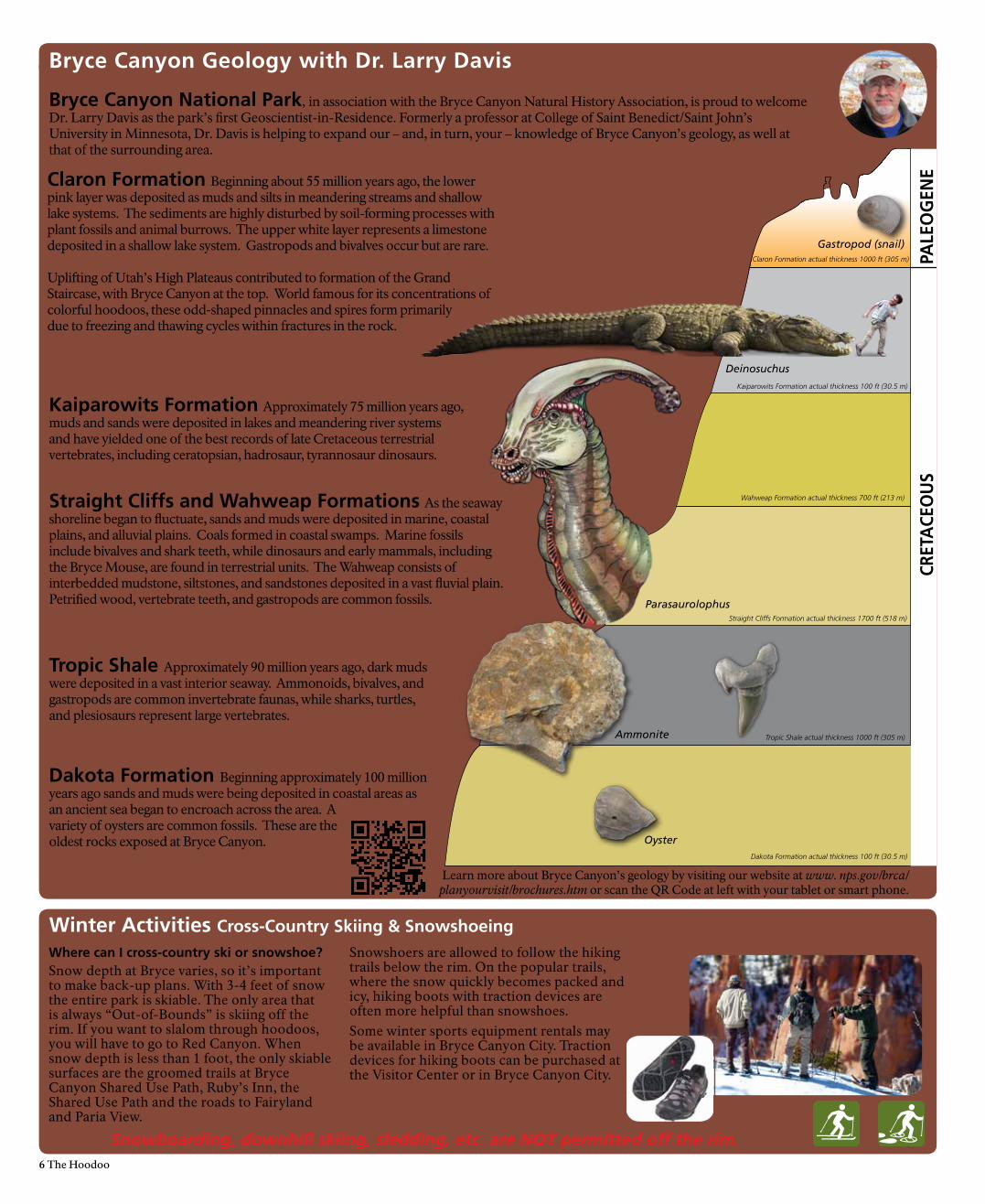
Bryce Canyon Geology with Dr. Larry Davis
DAKOTA FORMATION
TROPIC SHALE
STRAIGHT CLIFFSFORMATION
WAHWEAPFORMATION
KAIPAROWITSFORMATION
WAHWEAPFORMATION
CLARONFORMATION
CRET
ACE
OU
SPA
LEO
GEN
E
Tropic Shale Approximately 90 million years ago, dark muds were deposited in a vast interior seaway. Ammonoids, bivalves, and gastropods are common invertebrate faunas, while sharks, turtles, and plesiosaurs represent large vertebrates.
Ammonite
Oyster
Kaiparowits Formation Approximately 75 million years ago, muds and sands were deposited in lakes and meandering river systems and have yielded one of the best records of late Cretaceous terrestrial vertebrates, including ceratopsian, hadrosaur, tyrannosaur dinosaurs.
Dakota Formation Beginning approximately 100 million years ago sands and muds were being deposited in coastal areas as an ancient sea began to encroach across the area. A variety of oysters are common fossils. These are the oldest rocks exposed at Bryce Canyon.
Claron Formation Beginning about 55 million years ago, the lower pink layer was deposited as muds and silts in meandering streams and shallow lake systems. The sediments are highly disturbed by soil-forming processes with plant fossils and animal burrows. The upper white layer represents a limestone deposited in a shallow lake system. Gastropods and bivalves occur but are rare. Uplifting of Utah’s High Plateaus contributed to formation of the Grand Staircase, with Bryce Canyon at the top. World famous for its concentrations of colorful hoodoos, these odd-shaped pinnacles and spires form primarilydue to freezing and thawing cycles within fractures in the rock.
Straight Cliffs and Wahweap Formations As the seaway shoreline began to fluctuate, sands and muds were deposited in marine, coastal plains, and alluvial plains. Coals formed in coastal swamps. Marine fossils include bivalves and shark teeth, while dinosaurs and early mammals, including the Bryce Mouse, are found in terrestrial units. The Wahweap consists of interbedded mudstone, siltstones, and sandstones deposited in a vast fluvial plain. Petrified wood, vertebrate teeth, and gastropods are common fossils.
Bryce Canyon National Park, in association with the Bryce Canyon Natural History Association, is proud to welcome Dr. Larry Davis as the park’s first Geoscientist-in-Residence. Formerly a professor at College of Saint Benedict/Saint John’s University in Minnesota, Dr. Davis is helping to expand our – and, in turn, your – knowledge of Bryce Canyon’s geology, as well at that of the surrounding area.
Learn more about Bryce Canyon’s geology by visiting our website at www. nps.gov/brca/planyourvisit/brochures.htm or scan the QR Code at left with your tablet or smart phone.
Parasaurolophus
Deinosuchus
Gastropod (snail)Claron Formation actual thickness 1000 ft (305 m)
Kaiparowits Formation actual thickness 100 ft (30.5 m)
Wahweap Formation actual thickness 700 ft (213 m)
Straight Cliffs Formation actual thickness 1700 ft (518 m)
Tropic Shale actual thickness 1000 ft (305 m)
Dakota Formation actual thickness 100 ft (30.5 m)
Where can I cross-country ski or snowshoe?Snow depth at Bryce varies, so it’s important to make back-up plans. With 3-4 feet of snow the entire park is skiable. The only area that is always “Out-of-Bounds” is skiing off the rim. If you want to slalom through hoodoos, you will have to go to Red Canyon. When snow depth is less than 1 foot, the only skiable surfaces are the groomed trails at Bryce Canyon Shared Use Path, Ruby’s Inn, the Shared Use Path and the roads to Fairyland and Paria View.
Snowshoers are allowed to follow the hiking trails below the rim. On the popular trails, where the snow quickly becomes packed and icy, hiking boots with traction devices are often more helpful than snowshoes.Some winter sports equipment rentals may be available in Bryce Canyon City. Traction devices for hiking boots can be purchased at the Visitor Center or in Bryce Canyon City.
Snowboarding, downhill skiing, sledding, etc. are NOT permitted off the rim.
Bryce Canyon National Park works with our local partners to help create memories that last a l ifetime. For example, if you’ve hiked a trai l or attended a ranger program, then you have benefited from the Dollar Donation Program, a partnership between the park, Bryce Canyon Natural History Association, Ruby’s Inn Resort, Forever Resorts, and vis itors l ike you.
Funds from the Dollar Donation Program help to support Bryce Canyon National Park in many ways, including: vis itor information and exhibit panels, trai l maintenance and restoration, summer ranger programs, special events, wildl ife research, search and rescue equipment, free publications, and more.
H oodoo You ?Love Love
Bryce Canyon National Park is grateful to its generous donors and partners who help improve park programs and services.
Since 1961 the Bryce Canyon Natural History Association has contributed more than $6 million by providing the park with funds that support:
• The Junior Ranger Program• This Hoodoo newspaper and
other publications• The Geology Festival,
Astronomy Festival and other special events and interpretive programs
• A full-time Education Outreach Specialist and the Geo-scientist-in-Park
Since 2008, the Geologic Society of America has funded two Geo scientist-in-Park interns. These interns assist with:
• Research• Present public geology
programs each summer• Provide training for park
staff on the geology of the Colorado Plateau
The Lodge at Bryce Canyon and Ruby’s Inn Resort have implemented a Dollar Donation Program. Hotel guests have the option of donating a dollar to the park each night of their visit. Nearly $500,000 has been contributed to fund:
• Seasonal employees for interpretation and the trail crew
• Projects such as the recent addition of restrooms at Inspiration Point & Mossy Cave.
Thanks! We couldn’t do it without you!
Thank You to Our Donors & Partners
Bryce Canyon Natural History AssociationProviding Memories,Inspiring Stewardship
Enhance Your Visit
StayConnected
You Can Make a Difference
The Bryce Canyon Natural History Association (BCNHA) is the educational nonprofit partner assisting Bryce Canyon National Park and Dixie National Forest in furthering their scientific, educational, historical, and interpretive activities.
Since 1961, BCNHA has provided over six million dollars in support. This has been accomplished in part by creating educational publications and interpretive materials available for purchase or free distribution, and supporting popular interpretive activities like the Junior Ranger Program, Adopt-a-Prairie Dog Program and numerous special events and festivals.
BCNHA Store at the Visitor Center, you’ll find an outstanding selection of Bryce Canyon publications and products at our store that will help you further explore and appreciate this premiere geologic and recreational gem.
T-shirts, Cuddly Stuffed Animals, & much, much, more
You can preserve and protect the park for futuregenerations by becoming a BCNHA member today!
Your tax deductible membership dues will support the work of BCNHA. Members receive a 15% discount in BCNHA stores and online, a one time free gift, and discounts at most cooperating association bookstores in national parks and other public lands across the country.
Ask about membership at the Visitor Center, call us at888-362-2642 or visit
www.brycecanyon.org/membership
Coming this fall....New updated and redesigned website!
Visit us at www.brycecanyon.org
Bryce Canyon NaturalHistory Association
Present this couponat the visitor center
cash register to receiveyour free gift.
One gift per coupon
FREE GIFT
Bryce CanyonNatural HistoryA s s o c i a t i o n
8 The HoodooPrinted on recycled paper.
Please recycle again. 10-2015 120K
Printed with SOY INK
NEVADA
UTAH
ARIZONA
NEW
MEXICO
UTAH
COLORADO
89
89
Coral Pink Sand Dunes SP
St. George
Las Vegas
Cedar City
Rich�eld
NephiPrice
EphraimManti
Kanab
Page
Green River
Moab
Blanding
Monticello
TubaCity
Fredonia
ParowanPanguitch
Hurricane
Mesquite
Beaver
Fillmore
Gunnison
Salina
Blu�
Kayenta15
15
70
70
15
15
2424
24
12
24
89
89
89
89
89
89
89
191
191
191
191
191
191
191
95
95
491
163
160
160
160
89A
98
276
276
62
62
22
917
389
18
5618
67
14
14 143
20
28
6
6
10
10
128
160
12
130
257
Delta
Milford
Garrison
21
50
6
6
50
506
506
ColoradoCity
162
64
Mt. Carmel Jct.
Tropic
Cannonville
Escalante
Boulder
Torrey
Bicknell
LoaKoosharem
Antimony
Junction
Circleville
Hatch
Glendale
Springdale
Aurora
Scipio
Hanksville
Bullfrog
Halls Crossing
MexicanHat
Hite
Henrieville
BigWater
Cameron
Jacob Lake
NorthRim
SouthRim
Baker
132
Grand Jct.
Ganado
Chinle
191
191
264
26493
64
Shiprock
Gallup
Towaoc
Cortez
491
160
FerryCrossing
191
180
180
64
Flagsta�
Winslow
Holbrook
Kingman40
40
40
17
Williams
Grosvenor Arch
Calf Creek Falls
BullheadCity
Needles
95
Laughlin
68
50 1000
160800 kmmiles
Navajo Mtn.
Tuweep
Hwy 67Closed
Nov-April
Kolob Cyn
Zion NP
Grand Canyon NP
Glen Canyon NRA
LakeMeadNRA
Great BasinNP
CedarBreaksNM
Capitol Reef NP
BryceCanyonNP
Canyonlands NPArches NP
KaibabNF
GrandStaircase Escalante NM
DixieNF
FishLakeNF
Manti-La Sal NF
Manti- La SalNF
Grand Canyon-ParashantNM
NavajoNM
Manti- La SalNF
FishLakeNF
FishLakeNF
DixieNF
DixieNF
Dixie NF
Kaibab NF
VermilionCli�s NM
RainbowBridge NM
Monument Valley TribalPark
Antelope Slot Canyon Tribal Park
NaturalBridges NM
PipeSpringNM
Red Canyon
AnasaziState Park Museum
Escalante Petri�ed Forest SP
NAVA JO NATION
HOPI RESER VATION
Kodachrome Basin SP
GoblinValley SP
Edge of theCedars SP
CanyonDe ChellyNM
HubbellTrading Post NHS
HUALAPAIRESER VATION
HAVASUPAI
RESERVATION
FremontIndianVillageSP
MesaVerdeNP
UTE MOUNTAIN RESER VATION
Manti- La SalNF
DeadHorsePointSP
SnowCanyonSP
Petri�ed Forest NP
Walnut Canyon NM
Wupatki NM
Sunset Crater NM
Valley of Fire SP
GrandCanyonSkywalk
Otter Creek SP
Piute SP
North
National ForestsBureau of Land Management
National Park Service
Key to Public Lands
State Parks
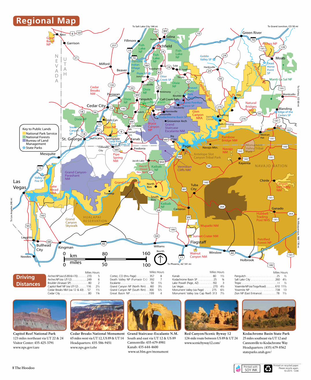
Capitol Reef National Park123 miles northeast via UT 22 & 24Visitor Center: 435-425-3791 www.nps.gov/care
Cedar Breaks National Monument 65 miles west via UT 12, US 89 & UT 14Headquarters: 435-586-9451 www.nps.gov/cebr
Grand Staircase-Escalante N.M.South and east via UT 12 & US 89 Cannonville: 435-679-8981 Kanab: 435-644-4600 www.ut.blm.gov/monument
Red Canyon/Scenic Byway 12124-mile route between US 89 & UT 24 www.scenicbyway12.com/