The Hooghly Estuarine System, NE Coast of Bay of Bengal, India. Dr. S. K. Mukhopadhyay Central Salt & Marine Chemicals Research Institute Bhavnagar. Workshop on Indian Estuaries, NIO, Goa June 25, 2007 CSMCRI
Transcript
The Hooghly Estuarine System, NE Coast of Bay of Bengal, India.
Dr. S. K. MukhopadhyayCentral Salt & Marine Chemicals
Research InstituteBhavnagar.
Workshop on Indian Estuaries, NIO, Goa June 25, 2007
CSMCRI
General features One of the major estuaries of the Ganges, the
largest as well as longest river of Indian subcontinent.
The Hooghly estuary, the first deltaic offshoot of the Ganges is a coastal plain estuary and lies approximately between 21°31′–23°20′N and 87°45′–88°45′E
Associated with the world’s largest mangrove forest, the Sundarbans Mangrove Biosphere Reserve.
Part of the world's largest delta is the Ganges-Brahmaputra delta, which lies partly in Bangladesh and partly in India.
This low-lying fertile plain is one of the world's most densely populated areas.
Navigable waterway for major port like Calcutta and Haldia
Physical Features Funnel shaped estuary; The breadth and cross-sectional area at the
mouth if 25km and 156250m2 and this decreases to to 6 km and 36,799m2 at the head end.
The area of cross-section can be related to distance by the expression Ax=Ao e−kx, where Ax is the area of cross-section of distance x, x is the distance measured land wards, Ao is the area of cross-section at the mouth and k is a constant (0.0241).
Mixing zones of the estuary extends upto Diamond harbour, about 80 km upstream.
This estuary receives 4 small rivers. River Damodar and Rupnarayan at its head, and River Haldi and Rasulpur at the middle.
This estuary is very shallow, depth is only 6m on the average and nowhere deeper than 20m. (Biswas, 1985)
Geomorphologically, it can be classified as coastal plain estuary. The important morphotypes are, tidal island, tidal bars, beaches, mudflats, sandflats, coastal dunes, creeks, inlets and mangrove swamp.
This delta is ornamented with large number of tidal bars and tidal islands of which Sagar Island, Lower Long Sand, and Nayachar are important.
Sagar Island, the largest of the Sundarban biosphere positioned at the mouth of the estuary and bifurcates it into two channels, the western channel is retained as Hooghly and eastern is named as Mooriganga.
Semidiurnal tide (M2) type. The overall spring tide ranges were of the order of 4.27 m to 4.57 m and ranges of
the neap tides were about 1.83 m to 2.83 m. (Fig. 1) Tidal influence is felt upto distance 300km Tide exhibits a positive asymmetry, which became stronger as it propagates along
the channel. The ratio M4/M2 and the phase difference is presented in figure 2 & 3. In the Tidal cycle flood tide is of short duration, 3 to 4 hours, while the ebb flows
remaining 8 to 9 hours. Flood velocities much higher than the ebb. Seasonal variation: Weak tide in the winter months (3-4 months), strong tide from
February to May, followed by a small period of relatively weaker tide and then again a strong tide (4 – 5 months) during pre-winter season. Table 1
Crest of the tidal waves is east to west direction. Tidal currents are relatively uniform. In the major portion of the estuary the flood
currents varied from 0.5 to 2.0 m s-1 with an average of 1.2 m s-1. Ebb currents varied between 0.2 and 1.4 m s-1
The magnitude of residual current varies from 0.1 to 0.4 m s-1
(a)
0
0.1
0.2
0.3
0.4
0 10 20 30 40 50 60 70
Distance from mouth (km)
M4
/ M2
(b)
90
100
110
120
130
0 10 20 30 40 50 60 70Distance from mouth (km)
2M2
- M
4 (d
eg.)
Tidal features
Climatic features Climatic condition is dominated by NE & SW monsoon. Seasonal climate in the
Northeast coast of Bay of Bengal and this tropical estuarine region may be conveniently categorized into following seasons.
Pre-monsoon (February to May): with little or no rainfall and prevalence of high temperature. Monsoon (June to September): when heavy atmospheric precipitation and comparatively low temperature are experienced. Post-monsoon: when there is occasional rainfall and minimum temperature were recorded.
Progressive increase in temperature from January to May followed by a decline with the onset of southwest monsoon from June onwards and reaches minimum during the end of the year. The water temperature also followed the same trend in this estuarine region.
Wind pattern in the estuary is more or less in line with the general wind system of the Indian subcontinent. The coastal region is characterized by two dominant wind system namely South-West and North-East. SW winds prevail from May to October with occasional disturbances with cyclone.
Annual rainfall varied between 188 cm to 245 cm, 75 – 85 % of the total annual rainfall occurred during monsoon months.
Monthly variation of meteorological parameters in the Hooghly estuarine region. Presented data in the table is averaged over a period of 10 years. Data Source IMD, Kolkata
Meteorological data
Station locations Data presented in the coming slides were
collected during 1998-2001 in every months and the average annual data is presented.
Three stations were selected along the mixing zone of the estuary.
Station 1, Beguakhali (coastal): Location 88o46.6/E 21o 41.2/ N situated at the confluence of the Hooghly river and Bay of Bengal and at the tip of the eastern flunk of the estuarine funnel, where it reaches its maximum width, about 28 km.
Station 2, Kachuberia (estuarine): Location 88o8.15/E and latitude 21o 52.72/ N. Situated at the northern most tip of the Sagar Island, where the Hooghly River bifurcates.
Station 3, Diamond Harbour (riverine): Location 88o 9.0/E and 22o 8.78/ N. Situated at the main land about 60 km down from Calcutta. Extreme upstream end of the mixing zone.
Salinity
0
10
20
30
Premonsoon Monsoon Postmonsoon
Sal
inity
(psu
)Riverine (St.1)Estuarine (St.2)Coastal (St.3)
0.527.8916.02Dec
0.465.6612.12Nov
0.212.988.78Oct
0.091.095.82Sept
0.153.4910.20Aug
0.387.2012.60Jul
1.2410.3016.19Jun
2.0519.9527.93May
1.8515.5625.10Apr
1.5613.1521.38Mar
1.3211.4819.66Feb
0.928.4217.72Jan
Station 3Station 2Station 1MonthHigher values of salinity at all stations
were found during premonsoon months and max. values were observed in May. Decrease of salinity from June onwards was found after the onset of SW monsoon with increasing fresh water influx. Minimum values were recorded during freshet in September.
Vertical distribution of salinity is not much pronounced, It varies from 0.3 to 2.1 psu in premonsoon, 1.2 to 3.1 psu in monsoon and 0.5 to 2.2 psu in postmonsoon. Well mixed estuary with slight startification in monsoon.
After commisioning of Farakka Barrage salt front was pushed seaward and rarely penetrate beyond Diamond harbour, 80 km from river mouth.
Suspended Particulate Matter
64.054.022.0Dec
101.085.028.0Nov
142.0103.082.0Oct
282.0206.0120.0Sept
182.0161.0109.0Aug
140.0131.064.0Jul
132.0129.051.0Jun
45.035.014.0May
48.044.023.0Apr
39.626.933.0Mar
30.024.012.0Feb
48.042.018.0Jan
Station 3Station 2Station 1MonthAnnual sediment load fed into the Bhagirathi –
Hooghly sub-delta is about 20 x 106 t, about 4% of the annual sediment discharge of the Ganges.
Large variations of suspended matter concentration down the estuary were observed. At station 3, SPM concentrations varied between 30 and 282 mg l-1 and its value decreased to 12 to 120 mg l-1 at station 1.
Increasing trend from premonsoon to postmonsoon and to monsoon seasons.
Decreasing trend from riverine to mixing and to coastal regions during all the seasons.
On an average 58% of the SPM settled within the estuarine stretch which resulted in the formation of number of banks and shoals (De et al., 1990).
Concentration of suspended sediment in surface water was found to decrease exponentially with respect to salinitySPM = 109.9e-0.0718xS (r = -0.706)
y = 109.9e-0.0718x
R2 = 0.4986
0
100
200
300
0 5 10 15 20 25 30
Salinity (ppt)
SPM
(mg l
-1)
Hydrology• The average discharge in this river system
was about 10% of the average discharge of the Indo-Gangetic delta.
• The fresh water inflow in the Bhagirathi-Hooghly river constituted mainly of 3 components:
• Western tributaries of the river Bhagirathi – Hooghly (Babla River, Pagla River, Ajay River) constituted about 30%.
• Major distributaries like Bhairab, Jalengi, Mathabhanga, Churni.
• Discharge from Farakka barrage values are: Monsoonal discharge 2975 ± 1144 m3 s-1, 4000 m3 s-1 during freshet (September)premonsoon (lean period) avg. 1000 ± 81.6 m3 s-1 and the min 900 m3 s-1 during May.postmonsoon discharge values were moderate 1875 ± 985.5 m3 s-1
• Watershed area of Bhagirathi – Hooghly is 60000 km2
• Surface run off was calculated using VQ = 1000. A. r. [exp. (-eo/r)] eo = 1.0 x 10⁹ exp. (-4.62 x 10³ / T)Surface runoff was calculated to be the order of 21.15 km3 per month during September (freshet) and 18.7 km3 during July (establishment phase of monsoon) 1.93Oct
20.47Sept
8.47Aug
18.70Jul
4.02Jun
0.88May
Discharge in Km3/monthMonth
Mixing characteristics
36.71Dec.
35.39Nov.
14.28Oct.
5.33Sept.
8.40Aug.
5.34Jul.
15.55Jun.
31.35May
49.90Apr.
45.89Mar.
42.97Feb.
39.39Jan.
Flushing time, T (tidal cycles)
Month
The flushing time ‘T’ is given by T = F/R, where R is the inflow of fresh water and F is the total volume of fresh water accumulated in the estuary.
F = Σ f. δVWhere f is the fraction of fresh water content, and volume of the segments.
Flushing time 49.9 tidal cycles (maximum) during April and 5.32 tidal cycles (minimum) during September.
A significant negative correlation was observed between the flushing time (T) and river discharge (R). T = - 0.0438R + 41.435 (r = - 0.864).
Salinity intrusion in a estuary is a balance between landward transport of salt by tidal processes and its seaward return by fresh water inflow. The extent of salinity intrusion relationship between variation of salinity and landward distance from the mouth of the river.a) Premonsoon: D = 84.92 – 2.595 S%o (r = -0.986)b) Postmonsoon: D = 70.63 – 3.76 S%o (r = -0.995)c) Monsoon: D = 53.79 – 7.19 S%o (r = -0.965)
Nutrients (DIN & Silicate)
Higher concentrations of DIN, and silicate-Si were found to occur during the monsoon; and reached minimum values during premonsoon.
Decreasing trend was observed towards seaend.
Nutrients (DRP& DIC) Higher concentrations of DRP,
were found to occur during the monsoon; and reached minimum values during premonsoon, whereas, DIC showed an opposite trend.
Decreasing trend of DRP was observed towards seaend. DIC showed a diffuse trend.
The worldwide average river water concentrations are 16.1μM and 0.65μM for NO3 and DRP, respectively (Froelich et al., 1982; Meybeck, 1982). The mean value of 102.9±43.2μM for silicate-Si was found lower than worldwide average river water concentration of 147.8±93.6μM (GEMS, 2002).
Both nitrate and phosphateconcentrations remained almost stable varied between 19.28 and 19.4μM for DIN and between 1.61and 1.99μM for DRP during the period between 1975 and 2001 but silicate showed a distinct increasing trendfrom 35.6 to 102.9μM (Nandy et al., 1983; NIO, 1986; Ghosh et al., 1992).
The variation of dissolved oxygen showed that the estuary was unsaturated (79.9–90.67%) with respect to oxygen during monsoon. The degree of oxygen saturation was found increased to 94.7–110.9% during postmonsoon and premonsoon
Values in the table are in mg/l and values in parentheses indicate
8.06 995.0)7.99 (95.6)8.06 (101.1)Dec
7.39 (93.3)7.48 (94.8)7.75 (101.5)Nov
7.08 (90.9)7.19 (94.3)7.32 (98.98)Oct
6.39 (82.8)6.48 (84.0)6.52 (86.81)Sept
6.03 (79.9)6.06 (80.2)6.03 (83.52)Aug
6.25 (82.5)6.29 (85.8)5.97 (83.88)Jul
6.60 (89.4)6.32 (90.3)6.22 (90.67)Jun
6.95 (100.5)6.53 (102.7)6.62 (109.6)May
7.28 (101.4)6.68 (98.6)7.08 (110.9)Apr
7.15 (95.3)6.75 (97.76.99 (104.5)Mar
7.41 (94.7)7.28 (97.8)7.36 (102.5)Feb
7.95 (95.2)8.05 (99.4)8.18 (105.9)Jan
Station 3Station 2Station 1Month
60
80
100
120
0 5 10 15 20 25 30
Satu
ratio
n (%
)
St.1St. 2St. 3
Dissolved Oxygen
Chlorophyll-a concentrations were found to be 3.0±0.60, 2.67±0.84 and 2.55±0.79 mg m−3 for stn.1, stn.2 and stn.3, respectively.
Mean photic zone light energy (Malone, 1977) was found to be 35.0±6.7 W m−2. This value is very close to the half saturation light intensity (KI) for diatom (15–30) W m−2 and dinoflagellates (37–45) W m−2.
The gross primary production reached minimum values at all stations during monsoon.
Photosynthetic efficiency as represented by photosynthetic index (PI) never exceeded 0.1 (Table 2), while annual average of PI for coastal water being 0.4 (Lalli and Parsons, 1997).
Both gross primary production and community respiration showed higher values at the river end (Stn3) compared to Stn1 and 2 and P/R ratio averaged 0.49±0.08.
Variation in phytoplankton population between 12.2 6x10⁵ and 77.6 x10⁵ cells m3 were observed by De et al. during monsoon and post-monsoon, respectively.
Species belonging to the genera Coscinodiscus, Rhizosolenia, Chaetoceros, Biddulphia occurred almost throughoutthe year. Coscinodiscus contributed 34 to 70.8% to the total population.
0
10
20
30
40
50
60
Jan. Feb Mar. Apr. May Jun. Jul. Aug. Sep. Oct. Nov. Dec.
mg
C m
-3 h
-1
St.1(GPP)St. 2(GPP) St. 3(GPP)St. 1(R)St. 2(R)St. 3(R)
Biological Parameters
Material fluxCalculated based on the LOICZ biogeochemical modeling guidelines.VR = VQ – VP – VG – VO + VP VX = VRSR / (SSys – SOcn)
Fresh water inflows (Surface runoff, VQ;Precipitation, VP; Sewage discharge, VO; and Ground water release, VG) into this estuarine system were considered equivalent to the outflow and their difference with evaporation, VE represents the residual flow (VR).The inflow and outflow of seawater from outside the system were described as exchange flow (VX).Equation for Salt budget:
Σ(VRSR + VXSOcn) - Σ(VXSSys) = 0
where S=salinity or conc. of nutrients, SR=( SSys+SOcn)/2, Δ=addition/removal. where SR, salinity of the out flowing water, was considered as the average salinity of the systems of interest, SSys, and the average salinity (SOcn) of the adjacent seawater was considered for inflowing water. Residence time of water (τ) was calculated dividing total volume of system (VSys) by (VR+VX). The Hooghly estuary was considered into three boxes
Annual water (fluxes in 10 9m3) and salt (fluxes in 10 9kg)budgets, and expressed as the sum of the results obtained for 3individual seasons (premonsoon, monsoon and postmonsoon).
Water, Salt & Sediment budget
This indicates 25% of the Ganges water discharge (460km3 year−1, GEMS, 2002) goes via the Hooghly estuary and remaining part of the water goes through Padma channel (Bangladesh).
Annual salt flux is 2106X109 kg
Mean values of residence time (τ) for the estuary were found to be 24.5, 4.7 and 18.6days during premonsoon, monsoon and postmonsoon, respectively.
Annual load of sediment out of the estuary to the NE coast of Bay of Bengal was estimated to be 65.19×10⁶t and monsoonal runoff could account 88% of the total transport.
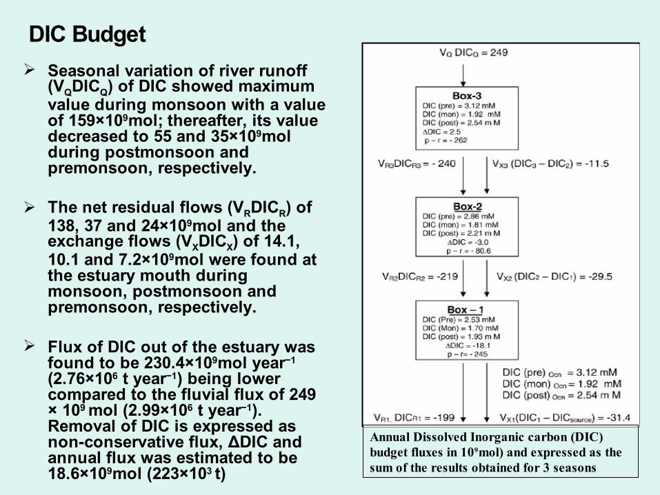
Annual Dissolved Inorganic carbon (DIC) budget fluxes in 109mol) and expressed as the sum of the results obtained for 3 seasons
DIC Budget Seasonal variation of river runoff
(VQDICQ) of DIC showed maximum value during monsoon with a value of 159×109mol; thereafter, its value decreased to 55 and 35×109mol during postmonsoon and premonsoon, respectively.
The net residual flows (VRDICR) of 138, 37 and 24×109mol and the exchange flows (VXDICX) of 14.1, 10.1 and 7.2×10⁹mol were found at the estuary mouth during monsoon, postmonsoon and premonsoon, respectively.
Flux of DIC out of the estuary was found to be 230.4×10⁹mol year−1 (2.76×10⁶ t year−1) being lower compared to the fluvial flux of 249 × 109 mol (2.99×10⁶ t year−1). Removal of DIC is expressed as non-conservative flux, ΔDIC and annual flux was estimated to be 18.6×10⁹mol (223×103 t)
Annual Dissolved Inorganic Nitrogen (DIN) budget fluxes in 106mol) and expressed as the sum of the results obtained for 3 seasons
DIN Budget River runoff(VQDINQ) of DIN
decreased from 2089.8×106mol in the monsoon to 589.0×10⁶mol in the postmonsoon and further to 282.4×10⁶ mol in the premonsoon.
The net residual flows (VRDINR) of 957.9, 157.4 and 70.5×10⁶mol and the exchange flows (VXDINX) of 2683.9, 474.8 and 360.7×10⁶ mol were found at the estuary mouth during monsoon, postmonsoon and premonsoon, respectively with an annual flux of 4705×106mol.
Its annual flux out of the estuary was estimated to be 4705×106mol (65.8×10³ t) which was about 1.6 times of fluvial flux of 2961×106mol (41.0×10³ t). The non-conservative flux estimation showed that the Hooghly estuary was a source of DIN with an annual addition of 1.74×10⁹mol (24.4×10³ t) for DIN.
Annual Dissolved Reactive Phosphorous (DRP) budget fluxes in 106mol) and expressed as the sum of the results obtained for 3 seasons
DRP Budget Seasonal variations of river runoff
(VQDRPQ) of DRP were found to be 219.0, 45.7 and 22.3×10⁶ mol during monsoon, postmonsoon and premonsoon, respectively.
The net residual flows (VRDRPR) of 111.0, 21.0 and 10.1×10⁶mol and the exchange flows (VXDRPX) of 200.0, 42.0 and 31.0×10⁶mol were found at the estuary mouth during monsoon, postmonsoon and premonsoon, respectively with an annual flux of 415×106mol (12.8×10³ t).
The Hooghly estuary was a net source of DRP with an annual addition of 128×106 mol (3.9×10³ t).
Annual Silicate-Si budget fluxes in 109mol) and expressed as the sum of the results obtained for 3 seasons
Silicate Budget Seasonal variation of river runoff
(VQSiQ) of silicate showed maximum value of 12.6×10⁹ mol during monsoon; thereafter, its value decreased to 2.54 and 1.33×10⁹ mol during postmonsoon and premonsoon, respectively.
The net residual flows (VRSiR) of 4.91, 1.47 and 0.5×10⁹ and the exchange flux (VXSiX) of 6.95, 0.94 and 0.51×10⁹ mol were found at the estuary mouth during monsoon, postmonsoon and premonsoon, respectively.
The annual flux of silicate out of the
estuary was estimated to be 15.28×10⁹mol (428×103 t) and it was about 93% of the fluvial flux.
The nonconservative flux of silicate removed from the water column was found to be 1.12 × 10⁹ mol (31.0×10³ t), which is about 5% in the global scale (0.6×10⁶ t year−1, Tregguer et al., 1995).
Fluxes (F) were calculated according to the expression: F = K.α. ∆P
where F is the flux in mol m-2 s-1, K is the exchange coefficientin m s-1, α is the solubility coefficient in molm-3 atm-1 and ∆P is the CO2 gradient through the interface [PCO2(water) –PCO2(air)] in atmosphere.
The estimation of the CO2exchange coefficient in estuarine water is a matter open to debate. Its average value of 0.093 m h-1 was determined by using the power relationships of Wanninkhof and these relationships were used to calculate the CO2 exchange flux in the Hooghly estuary.
Air-water exchange of gases
High degree of supersaturation of carbon dioxide with respect to atmosphere during pre-monsoon. Surface water was under saturated with respect to atmospheric CO2 during monsoon.
This estuary acts as a source of CO2 during premonsoon with maximum emission rate of 84.4 mmol m2 d-1in April. The exchange pattern of CO2 was found reverse during freshet and this estuary acts as a sink for CO2 with a maximum rate of 22.78 mmol m2 d-1.
CO2 Exchange
Surface water concentration found maximum during monsoon. This indicate high amount of methane is transported from mangrove forest during monsooon
Diffusive flux at sediment water interface found maximum during postmonsoon.
Methane evasion rate found maximum during premonsoon