59 ABSTRACT: MATTAVELLI M., STRIGARO D., FRIGERIO I., LOCCI F., ME- LIS M.T. & DE AMICIS M., The IDB: An ice core geodatabase for paleocli- matic and glaciological analyses. (IT ISSN 0391-9838, 2016) The Italian national project, NEXTDATA, is focused to favour the implementation of measurements networks in remote mountain and ma- rine areas and develop efficient database structure to archive and access meteoclimatic and paleoclimatic proxies derived from ice core, marine core, tree ring and pollen. They give precious information about the evo- lution of anthropogenic pollution, climate variability and about the com- position of middle troposphere. The main object of this work is to devel- op the Ice core DataBase (IDB), an interoperability architecture based on a spatial database that contains physical and chemical characterization data about non-polar ice core. The principal scope is to build an efficient web portal where paleo-scientist can easily and quickly access to specif- ic proxy data useful for paleoclimatic analysis. The ice core geographic information is useful to evaluate the glacier suitability for ice core drill- ing of mountain glaciers and to reconstruct the last 2k of Italy climatic history. Starting with an accurate bibliography research we managed to collect a great amount of ice core data and metadata that were essential to study a suitable methodology to reach the study goals. Data collected were integrated in an information system through specific web services. The developed applications were based on open source software tools such as PostgreSQL and PostGIS for database, Geoserver and Leaflet for webGIS. The geospatial services were implemented with the techni- cal specifications proposed by OGC and INSPIRE standards in order to maximize data interoperability. KEYWORDS: Ice core, Glacier, Paleoclimate proxy, Geodatabase, webGIS. RIASSUNTO: MATTAVELLI M, STRIGARO D., FRIGERIO I., LOCCI F., MELIS M.T. & DE AMICIS M., L’IDB: una geobase di dati sulle carote di ghi- accio per analisi paleoclimatiche e glaciologiche. (IT ISSN 0391-9838,2016) Il Progetto Nazionale Italiano, NEXDATA, ha lo scopo di favorire l’implementazione delle reti di misura nelle montagne poste in luoghi remoti e nelle aree marine e lo sviluppo di di efficienti strutture di basi di dati da archiviare e l’accesso agli indicatori metaclimatici e paleoclimati- ci derivati da carote di ghiaccio, carote marine, dendrologici, e palinolo- gici. Essi forniscono preziose informazioni sull’evoluzione dell’inquina- mento antropogenico, sulla variabilità del clima e la composizione della media troposfera. Il principale obiettivo di questo lavoro è lo sviluppo dell’Ice Core Data Base (IDB), una struttura interoperabile fondata su base di dati spaziali che contiene dati di caratterizzazione fisica e chimica su carote di ghiaccio non polari. Il principale scopo è di costruire un ef- ficiente portale web nel quale lo scienziato può facilmente e rapidamente accedere agli specifici dati di indicatori per analisi paleoclimatiche. L’informazione geografica sulle carote di ghiaccio è utile per valutare l’idoneità a eseguire carotaggi di ghiacciai montani e a ricostruire l’ul- timo 2K della storia climatica italiana. Partendo da un’accurata ricerca bibliografica noi abbiamo raccolto una grande quantità di dati di carote di ghiaccio e metadati che sono essenziali per studiare una metodologia adatta a raggiungere gli scopi dello studio. I dati raccolti sono stati inte- grati in un sistema informatizzato attraverso specifici servizi web. Le ap- plicazioni sviluppate sono basate su strumenti di software a fonte aperta (open source) quali PostgreSQL e PostGIS per le basi di dati, Geoserv- er e Leaflet per il webGIS. I servizi geospaziali sono stati implementati con le specifiche tecniche proposte dagli standard OGC e INSPIRE per massimizzare l’interoperabilità dei dati. TERMINI CHIAVE: Carote di ghiaccio, Indicatori paleoclimatici, Ge- odatabase, webGIS. INTRODUCTION For the past 50 years, the international scientific com- munity has studied non-polar ice cores as indicators of climate variability and environmental changes. The ice (*) Geomatic Laboratory, Università degli Studi di Milano-Bicocca, Milano Italy (**) Remote sensing & GIS, Università degli Studi di Cagliari, Cagliari Italy Corresponding author: Matteo Mattavelli ([email protected]) This work is a contribution to the NEXTDATA italian project, a na- tional system for the retrieval, storage, access and diffusion of environmen- tal and climate data from mountain and marine areas. It is funded by the Ministry of Education, Universities and Research (MIUR) and coordinated by the National Research Council (CNR). In a special way we would like to thank Prof. A. Provenzale for his suggestions and his advices during this work and for his coordination of the entire Nextdata Project. Geogr. Fis. Dinam. Quat. DOI 10.4461/ GFDQ. 2016.39.6 39 (2016). 59-70, 5 figg., 4 tabb. MATTEO MATTAVELLI (*), DANIELE STRIGARO (*), I VAN FRIGERIO (*), FILIPPO LOCCI (**), MARIA T ERESA MELIS (**) & MATTIA DE AMICIS (*) THE IDB: AN ICE CORE GEODATABASE FOR PALEOCLIMATIC AND GLACIOLOGICAL ANALYSES
Transcript
59
AbstrAct: Mattavelli M., Strigaro D., Frigerio i., locci F., Me-liS M.t. & De aMiciS M., The IDB: An ice core geodatabase for paleocli-matic and glaciological analyses.(IT ISSN 0391-9838, 2016)
The Italian national project, NEXTDATA, is focused to favour the implementation of measurements networks in remote mountain and ma-rine areas and develop efficient database structure to archive and access meteoclimatic and paleoclimatic proxies derived from ice core, marine core, tree ring and pollen. They give precious information about the evo-lution of anthropogenic pollution, climate variability and about the com-position of middle troposphere. The main object of this work is to devel-op the Ice core DataBase (IDB), an interoperability architecture based on a spatial database that contains physical and chemical characterization data about non-polar ice core. The principal scope is to build an efficient web portal where paleo-scientist can easily and quickly access to specif-ic proxy data useful for paleoclimatic analysis. The ice core geographic information is useful to evaluate the glacier suitability for ice core drill-ing of mountain glaciers and to reconstruct the last 2k of Italy climatic history. Starting with an accurate bibliography research we managed to collect a great amount of ice core data and metadata that were essential to study a suitable methodology to reach the study goals. Data collected were integrated in an information system through specific web services. The developed applications were based on open source software tools such as PostgreSQL and PostGIS for database, Geoserver and Leaflet for webGIS. The geospatial services were implemented with the techni-cal specifications proposed by OGC and INSPIRE standards in order to maximize data interoperability.
riAssunto: Mattavelli M, Strigaro D., Frigerio i., locci F., MeliS M.t. & De aMiciS M., L’IDB: una geobase di dati sulle carote di ghi-accio per analisi paleoclimatiche e glaciologiche. (IT ISSN 0391-9838,2016)
Il Progetto Nazionale Italiano, NEXDATA, ha lo scopo di favorire l’implementazione delle reti di misura nelle montagne poste in luoghi remoti e nelle aree marine e lo sviluppo di di efficienti strutture di basi di dati da archiviare e l’accesso agli indicatori metaclimatici e paleoclimati-ci derivati da carote di ghiaccio, carote marine, dendrologici, e palinolo-gici. Essi forniscono preziose informazioni sull’evoluzione dell’inquina-mento antropogenico, sulla variabilità del clima e la composizione della media troposfera. Il principale obiettivo di questo lavoro è lo sviluppo dell’Ice Core Data Base (IDB), una struttura interoperabile fondata su base di dati spaziali che contiene dati di caratterizzazione fisica e chimica su carote di ghiaccio non polari. Il principale scopo è di costruire un ef-ficiente portale web nel quale lo scienziato può facilmente e rapidamente accedere agli specifici dati di indicatori per analisi paleoclimatiche. L’informazione geografica sulle carote di ghiaccio è utile per valutare l’idoneità a eseguire carotaggi di ghiacciai montani e a ricostruire l’ul-timo 2K della storia climatica italiana. Partendo da un’accurata ricerca bibliografica noi abbiamo raccolto una grande quantità di dati di carote di ghiaccio e metadati che sono essenziali per studiare una metodologia adatta a raggiungere gli scopi dello studio. I dati raccolti sono stati inte-grati in un sistema informatizzato attraverso specifici servizi web. Le ap-plicazioni sviluppate sono basate su strumenti di software a fonte aperta (open source) quali PostgreSQL e PostGIS per le basi di dati, Geoserv-er e Leaflet per il webGIS. I servizi geospaziali sono stati implementati con le specifiche tecniche proposte dagli standard OGC e INSPIRE per massimizzare l’interoperabilità dei dati.
terMini chiave: Carote di ghiaccio, Indicatori paleoclimatici, Ge-odatabase, webGIS.
INTRODUCTION
For the past 50 years, the international scientific com-munity has studied non-polar ice cores as indicators of climate variability and environmental changes. The ice
(*) Geomatic Laboratory, Università degli Studi di Milano-Bicocca, Milano Italy
(**) Remote sensing & GIS, Università degli Studi di Cagliari, Cagliari Italy
This work is a contribution to the NEXTDATA italian project, a na-tional system for the retrieval, storage, access and diffusion of environmen-tal and climate data from mountain and marine areas. It is funded by the Ministry of Education, Universities and Research (MIUR) and coordinated by the National Research Council (CNR). In a special way we would like to thank Prof. A. Provenzale for his suggestions and his advices during this work and for his coordination of the entire Nextdata Project.
Matteo MATTAVELLI (*), Daniele STRIGARO (*), ivan FRIGERIO (*), Filippo LOCCI (**),Maria tereSa MELIS (**) & Mattia DE AMICIS (*)
THE IDB: AN ICE CORE GEODATABASE FOR PALEOCLIMATICAND GLACIOLOGICAL ANALYSES
60
cores were extracted from several glaciers located in trop-ical, subtropical and mid-latitude regions: South America, Africa, Hindu Kush – Karakorum – Himalaya (HKKH) region, Alaska, Russia and Europe (Jones & alii, 2009). The ice cores drilled in these glaciers conserve essential information about the temporal resolution of recent cli-mate variability, the evolution of anthropogenic pollution and information about the middle troposphere in rela-tion to climate change on a planetary scale (Duan & alii, 2007). The analyses performed on these ice cores produce a wealth of chemical and physical data that are used in pa-leoclimatic research.
This study is part of NEXTDATA, an Italian national projectthat aims to create an infrastructure of measurement networks in remote mountain and marine areas. The main goal of the NEXTDATA project is to create a system of archives and portals, connected through a General Portal, to access measured data, simulations, reanalysis results and scientific findings in an open-access, integrated and easy-to-use manner. A grand challenge of the NEXTDATA project is to provide information on the climatology and climate variability in Italy over the last two thousand years through a blend of paleoclimatic data information and numerical simulations. In this context, the development of an open-source geodatabase called the Ice Core DataBase (IDB) is one of the main products of the NEXTDATA project.
In this paper, we propose a methodology to recover, store, access and disseminate ice core data. Starting with the development of the IDB, a geoportal has been imple-mented to share data. This system will provide the scien-tific community with a useful instrument for paleoclimatic research, applications for environmental protection and assessments of climate change impacts.
The IDB has been implemented at the Laboratorio di Geomatica del Dipartimento di Scienze dell’Ambiente e del Territorio e di Scienze della Terra (Geomatic Laborato-ry of Earth and Environmental Department), University of Milano Bicocca, Italy) through collaboration with the Re-mote Sensing and GIS Group at the University of Cagliari.
NON-POLAR ICE CORES
In this study, we focused on ice cores drilled from mid-latitude regions (less than 60° of latitude) and high-al-titude glaciers, excluding ice caps and ice sheets. Glaciers in mid-latitude, tropical and sub-tropical regions are nat-ural archives of past precipitation, preserving paleo-cli-matic and palaeoatmospheric conditions (Thompson & alii, 1996). The climate of a region can be reconstructed because the accumulated snow, which contains atmospher-ic trace substances incorporated into the precipitation by in-cloud and below-cloud scavenging (Baltensperger & alii, 1998), is transformed to firn and ice through snow meta-morphosis, building a regularly layered archive.
The preserved information, such as the isotopic com-position of the deposited water molecules (e.g., δ18O and δD, which are proxies of temperature), can be accessed from ice cores recovered using drilling devices (Ginot & alii, 2002).
Cores from drill sites of non-polar glaciers have been widely used as environmental archives to reconstruct the depositional history of aerosol-related species over the 20th century (Preunkert & alii, 2000; Schwikowski & alii, 2004; Wagenbach & alii, 1988). The major strength of glacier ar-chives is their high temporal resolution, which can be an-nual or even seasonal if accumulation rates are sufficiently high. However, ice core records are occasionally difficult to interpret due to the possibility of post-depositional processes (e.g., wind erosion, sublimation or percolating melt-water introducing a bias into trace element records such as salts and acids). In this context, alpine firn/ice cores acquire a particular weight because they constitute an ir-replaceable natural historical archive of the anthropogenic impact of the European environment.
To this end, IDB results suitable to archive the ice cores characterization that will be used for multi-proxy paleo-climatic reconstructions (Ljungqvist & alii, 2010; Mann & alii, 2008, 2009).
AVAILABLE DATABASES
Data from ice cores and ice core analysis are general-ly archived in three principal repositories: PANGEA Data Publisher for Earth & Environmental Science (PANGEA 2014, www.pangaea.de), the NOAA National Climatic Data Center (NCDC NOAA 2013, www.ncdc.noaa.gov/pa-leo/icecore) and the National Ice Core Laboratory (NICL 2009, www.icecores.org).
PANGAEA Data Publisher for Earth & Environmental Science is a digital data library and a data publisher for earth system science. Data can be georeferenced in time (by date/time or geological age) and space (latitude, longi-tude, and depth/height). Scientific data are archived with related metadata in a relational database (Sybase) through an editorial system. Data are open-access and are distrib-uted through web services in standard formats through various Internet search engines and web portals. Dataset descriptions (metadata) conform to the ISO 19115 stan-dard and are also serve in various further formats (e.g., Directory Interchange Format, Dublin Core. Miller, 1996). They include a bibliographic citation and are consistently identified using digital object identifiers (DOIs). Identifier provision and long-term availability of datasets via library catalogues are ensured through cooperation with the Ger-man National Library of Science and Technology (TIB) and the database is available on the Worldwide Web (www.pangaea.de). In this geoportal a single parameter of an ice core can been searched by ice core name or principal in-vestigator. However it is not possible to download the sin-gle parameter searched; the user must download the entire dataset related to that specific ice core. A usable WebGIS for identifying the location of the ice cores and their spatial coverage has not yet been implemented.
The NOAA-NCDC database stores ice-core data from the NOAA Paleoclimatology Program. These ice cores are divided in 5 subgroups: Antarctica, Greenland, Other Polar Ice Cores, Tropical and Temperate Cores, and Sea Ice Cores. The entire dataset of a single ice core can be downloaded,
61
and a well-structured and user-friendly WebGIS has been implemented. However, the spatial position of the ice cores has low precision. For this reason most of the non-polar ice cores result locate outside the glaciers or at the peak of the mountain, etc. Moreover it is only possible download the entire dataset of the selected ice core in ASCII or tabular format. Commonly, these files are simply structured in two formats: the first is a metadata repository that supplies the principal investigator of the research and a reference to the paper wherein the data are published; the second are records of the chemical and physical analysis of the ice core, which is a limitation for scientists who require specific data.
The U.S. National Ice Core Laboratory (NICL) is a National Science Foundation (NSF) facility for storing, cu-rating, and studying meteoric ice cores recovered from the glaciated regions of the world. The NICL provides scien-tists with the capability to conduct examinations and mea-surements on ice cores. It preserves the integrity of these ice cores in a long-term repository for future investigations. This repository is not structured as a geodatabase in which the spatial information is one of the principal keys to en-able spatial queries. Furthermore, the NICL repository is not structured to archive each single numeric value from the analysis of the ice; thus, these data cannot be queried by the data provider, parameter of interest or ice core name. This repository also does not include chemical-physical characterization archives; instead, there is only a table with information about the ice cores stored at NICL.
In addition to this three archive, other data were pro-vided by local laboratories, in particular by EuroCold at University of Milano-Bicocca.
DATA
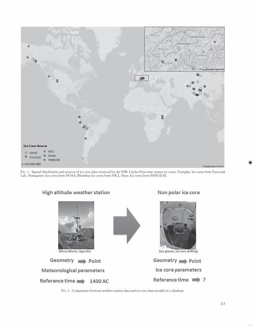
A total of 178 non-polar ice cores have been collected from 4 different sources. Amongst these cores, 56 coming from the NOAA and NICL databases, 2 ice cores coming from EuroCold, 3 ice cores coming from PANGEAE and 117 ice cores have been collected from the literature, geo-referenced and stored in a geodatabase for the first time (tab. 1). Previously, there were no geodatabase with geo-graphic and chemical/physical information on European ice cores. All the coordinates for each ice core were ob-tained after a careful literature search and are stored in the database according to the EPSG geodetic parameter reg-istry 4326. The accuracy of the spatial positions of the ice cores still remain problematic (as explain in Section 2.3).
All references and the principal investigator for each ice core can be found at http://geomatic.disat.unimib.it/idbpaper.
PROPOSAL AND DATABASE IMPLEMENTATION
To overcome the limitations of the NOAA and NICL databases, a new geodatabase structure, called the IDB, has been designed. Spatial and temporal information, to-gether with data derived from chemical and physical char-acterizations, is stored in the IDB. The IDB is structured as
a geographical database wherein the spatial information is defined by a couple of coordinates that identify a point on a non-polar glacier (fig. 1).
An existing database scheme has been adopted as a technical solution because one of the NEXTDATA proj-ect deliverables is to increase the interoperability between different paleoclimatic proxy data and meteorological data.
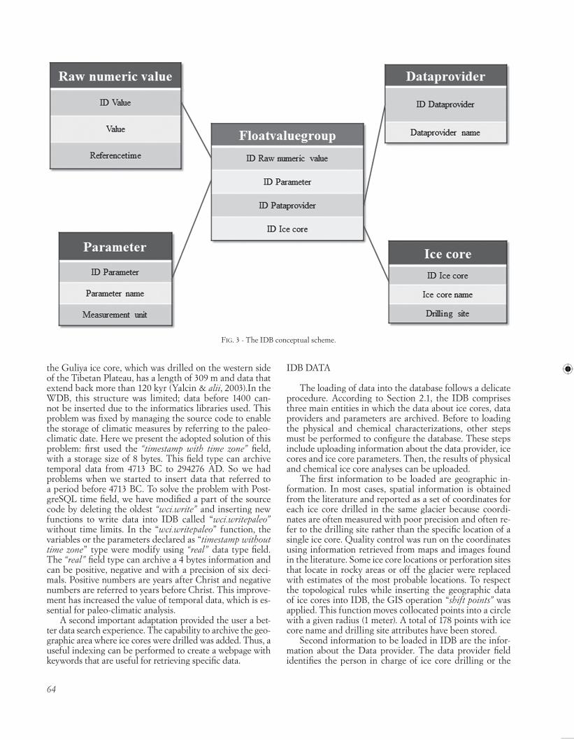
The adopted DB scheme was created by the Norwegian Meteorological Institute, which designed an open database to store meteorological, hydrological and oceanographic data. This database, called the WDB (Water and Weather Database System, TNM 2012, http://wdb.met.no), has pre-viously been used to improve the quality and effectiveness of IT systems for these types of data. The WDB architec-ture was selected to facilitate ice core comparisons with weather stations. From a conceptual standpoint, these two entities can be represented by two principal aspects:
• Geometry: ice cores and weather stations are represent-ed geographically with a couple of coordinates that can be represented as a punctual geometry in a GIS envi-ronment;
• Data typology: data from ice cores provide information about the past climate and climate trends, whereas data from weather stations provide information about the current climatic system. They store the same type of data, which is characterized by a numerical value with a parameter related to temporal information (fig. 2).
WDB has been released according to the GNU General Public License and is completely configurable, customiz-able and sharable.
ICE CORE DATABASE STRUCTURE: THE IDB
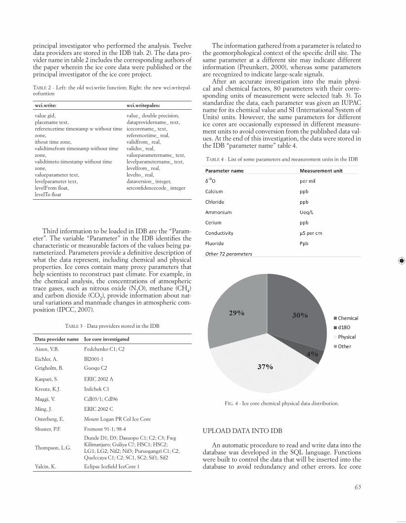
An accurate study of WDB architecture was performed to identify the best method to archive information regard-ing data providers, parameters and ice core data. Three main entities were selected to be the central core of the IDB: the first entity comprises tables of parameters derived from chemical and physical ice core measurements, the second entity is archived data provider information, and the third is ice core tables (fig. 3). The last entity is very useful because IDB can be related through spatial analysis with other similar databases, making the IDB a connec-tion between ice cores and other entities (e.g., data on gla-ciers from the Global Land Ice Measurements from Space, GLIMS, World Glacier, Inventory, WGI, etc.). The ‘float-value group’ table indicates where unique combinations of ice cores, parameters and data providers were archived to retrieve information quickly.
STRUCTURAL ADAPTATIONS
In general, the WDB has been a very good initial structure for the development of an ice core archive, as described in the above paragraph. However, some adapta-tions were made to the open-source WDB code to increase its suitability for paleoclimatic ice core proxies.
62
Whereas chemical and physical parameters are consid-ered identical in data from meteorological stations, paleo-climate data are completely different from weather data if the temporal factor is considered. In fact, the first network of meteorological measurements began in the second part of the seventeenth century thanks to the Medici family (Ca-
muffo & alii, 2012). Therefore, no weather data series start-ing before 1600 exist. In paleoclimatology, there are nat-ural archives of precious paleoclimatic information about the distant past. Ice cores in our research domain provide data for the last 20 kyr, particularly in the Tibetan Plateau (Delmas & alii,1992, Thompson & alii,1995). For example,
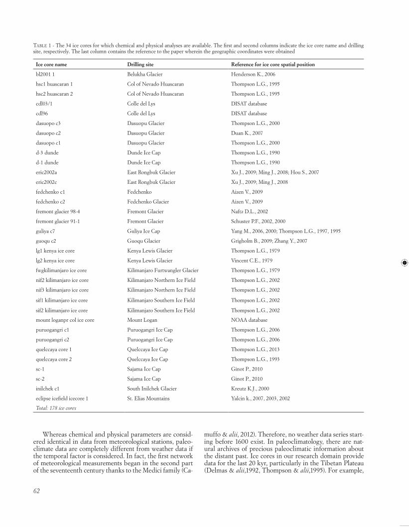
table 1 - The 34 ice cores for which chemical and physical analyses are available. The first and second columns indicate the ice core name and drilling site, respectively. The last column contains the reference to the paper wherein the geographic coordinates were obtained
Ice core name Drilling site Reference for ice core spatial position
bl2001 1 Belukha Glacier Henderson K., 2006
hsc1 huascaran 1 Col of Nevado Huascaran Thompson L.G., 1995
hsc2 huascaran 2 Col of Nevado Huascaran Thompson L.G., 1995
cdl03/1 Colle del Lys DISAT database
cdl96 Colle del Lys DISAT database
dasuopo c3 Dasuopu Glacier Thompson L.G., 2000
dasuopo c2 Dasuopu Glacier Duan K., 2007
dasuopo c1 Dasuopu Glacier Thompson L.G., 2000
d-3 dunde Dunde Ice Cap Thompson L.G., 1990
d-1 dunde Dunde Ice Cap Thompson L.G., 1990
eric2002a East Rongbuk Glacier Xu J., 2009; Ming J., 2008; Hou S., 2007
eric2002c East Rongbuk Glacier Xu J., 2009; Ming J., 2008
mount loganpr col ice core Mount Logan NOAA database
puruogangri c1 Puruogangri Ice Cap Thompson L.G., 2006
puruogangri c2 Puruogangri Ice Cap Thompson L.G., 2006
quelccaya core 1 Quelccaya Ice Cap Thompson L.G., 2013
quelccaya core 2 Quelccaya Ice Cap Thompson L.G., 1993
sc-1 Sajama Ice Cap Ginot P., 2010
sc-2 Sajama Ice Cap Ginot P., 2010
inilchek c1 South Inilchek Glacier Kreutz K.J., 2000
eclipse icefield icecore 1 St. Elias Mountains Yalcin k., 2007, 2003, 2002
Total: 178 ice cores
63
Fig. 1 - Spatial distribution and sources of ice core data retrieved for the IDB. Circles First time census ice cores; Triangles: Ice cores from Eurocold Lab.; Pentagones: Ice cores from NOAA, Rhombus Ice cores from NICL; Stars: Ice cores from PANGEAE.
Fig. 2 - Comparison between weather station data and ice core data storable in a database.
64
the Guliya ice core, which was drilled on the western side of the Tibetan Plateau, has a length of 309 m and data that extend back more than 120 kyr (Yalcin & alii, 2003).In the WDB, this structure was limited; data before 1400 can-not be inserted due to the informatics libraries used. This problem was fixed by managing the source code to enable the storage of climatic measures by referring to the paleo-climatic date. Here we present the adopted solution of this problem: first used the “timestamp with time zone” field, with a storage size of 8 bytes. This field type can archive temporal data from 4713 BC to 294276 AD. So we had problems when we started to insert data that referred to a period before 4713 BC. To solve the problem with Post-greSQL time field, we have modified a part of the source code by deleting the oldest “wci.write” and inserting new functions to write data into IDB called “wci.writepaleo” without time limits. In the “wci.writepaleo” function, the variables or the parameters declared as “timestamp without time zone” type were modify using “real” data type field. The “real” field type can archive a 4 bytes information and can be positive, negative and with a precision of six deci-mals. Positive numbers are years after Christ and negative numbers are referred to years before Christ. This improve-ment has increased the value of temporal data, which is es-sential for paleo-climatic analysis.
A second important adaptation provided the user a bet-ter data search experience. The capability to archive the geo-graphic area where ice cores were drilled was added. Thus, a useful indexing can be performed to create a webpage with keywords that are useful for retrieving specific data.
IDB DATA
The loading of data into the database follows a delicate procedure. According to Section 2.1, the IDB comprises three main entities in which the data about ice cores, data providers and parameters are archived. Before to loading the physical and chemical characterizations, other steps must be performed to configure the database. These steps include uploading information about the data provider, ice cores and ice core parameters. Then, the results of physical and chemical ice core analyses can be uploaded.
The first information to be loaded are geographic in-formation. In most cases, spatial information is obtained from the literature and reported as a set of coordinates for each ice core drilled in the same glacier because coordi-nates are often measured with poor precision and often re-fer to the drilling site rather than the specific location of a single ice core. Quality control was run on the coordinates using information retrieved from maps and images found in the literature. Some ice core locations or perforation sites that locate in rocky areas or off the glacier were replaced with estimates of the most probable locations. To respect the topological rules while inserting the geographic data of ice cores into IDB, the GIS operation “shift points” was applied. This function moves collocated points into a circle with a given radius (1 meter). A total of 178 points with ice core name and drilling site attributes have been stored.
Second information to be loaded in IDB are the infor-mation about the Data provider. The data provider field identifies the person in charge of ice core drilling or the
Fig. 3 - The IDB conceptual scheme.
65
principal investigator who performed the analysis. Twelve data providers are stored in the IDB (tab. 2). The data pro-vider name in table 2 includes the corresponding authors of the paper wherein the ice core data were published or the principal investigator of the ice core project.
Third information to be loaded in IDB are the “Param-eter”. The variable “Parameter” in the IDB identifies the characteristic or measurable factors of the values being pa-rameterized. Parameters provide a definitive description of what the data represent, including chemical and physical properties. Ice cores contain many proxy parameters that help scientists to reconstruct past climate. For example, in the chemical analysis, the concentrations of atmospheric trace gases, such as nitrous oxide (N2O), methane (CH4) and carbon dioxide (CO2), provide information about nat-ural variations and manmade changes in atmospheric com-position (IPCC, 2007).
table 2 - Left: the old wci.write function; Right: the new wci.writepal-eofuntion
wci.write:
value gid,placename text,referencetime timestamp w without time zone,ithout time zone,validtimefrom timestamp without time zone,validtimeto timestamp without time zone,valueparameter text,levelparameter text,levelFrom float,levelTo float
The information gathered from a parameter is related to the geomorphological context of the specific drill site. The same parameter at a different site may indicate different information (Preunkert, 2000), whereas some parameters are recognized to indicate large-scale signals.
After an accurate investigation into the main physi-cal and chemical factors, 80 parameters with their corre-sponding units of measurement were selected (tab. 3). To standardize the data, each parameter was given an IUPAC name for its chemical value and SI (International System of Units) units. However, the same parameters for different ice cores are occasionally expressed in different measure-ment units to avoid conversion from the published data val-ues. At the end of this investigation, the data were stored in the IDB “parameter name” table 4.
UPLOAD DATA INTO IDB
An automatic procedure to read and write data into the database was developed in the SQL language. Functions were built to control the data that will be inserted into the database to avoid redundancy and other errors. Ice core
Fig. 4 - Ice core chemical physical data distribution.
table 4 - List of some parameters and measurement units in the IDB
66
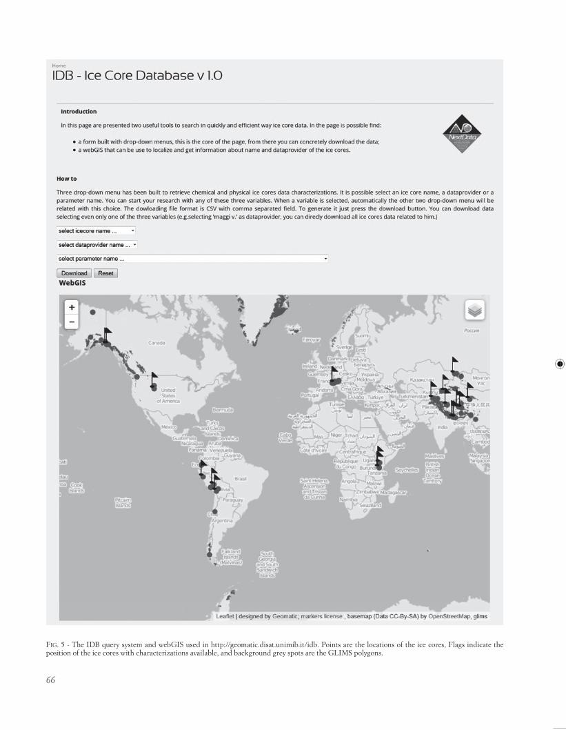
Fig. 5 - The IDB query system and webGIS used in http://geomatic.disat.unimib.it/idb. Points are the locations of the ice cores, Flags indicate the position of the ice cores with characterizations available, and background grey spots are the GLIMS polygons.
67
analyses are available for 34 of the 178 ice cores stored in the database. After the data were specified, a descriptive statistic was performed. As shown in figure 4, δ18O is one of the most common ice core proxies in the analysis of sta-ble isotopic ratios. Thirty percent of the loaded data relate to chemical analyses aiming to evaluate the amounts of dif-ferent elements in the ice core samples.
SHARING DATA VIA THE OPEN GEOSPATIAL CONSORTIUM
To enable data sharing, a web platform was developed on the Geomatic Laboratory server of the Dipartimento di Scienze Ambientali of the University of Milano-Bicocca. The working environment is based on open-source struc-tures in accordance with the NEXTDATA policy.
A web map service (WMS) and web feature service (WFS) based on Open Geospatial Consortium (OGC) services was created using Geoserver software (http://ge-oserver.org/). The OGC standards offer a method to share geospatial information and metadata, with multiple appli-cations increasing their interoperability. The web portal is equipped with a webGIS built with Leaflet (http://leafletjs.com/), in which ice cores are visualized spatially with their attributes. A visual interface for downloading the data was developed inside the web portal. To achieve this goal, two different access keys have been implemented:
I) Spatial position through a webGIS (fig. 5) II) A query system realized in a web page:
A form was built to retrieve chemical and physical char-acteristics of ice cores. Data can be searched through three main keys: ice core name, data provider and parameter name. In addition, the connection to PostGIS layers from a GIS client (Quantum GIS) allows expert users to execute spa-tial queries, such as geoprocessing operations.
All of these applications are available at http://geomatic.disat.unimib.it/idb.
Data and metadata stored in the IDB have also been archived in the SHARE Geonetwork, a system for climate and paleoclimate data sharing (Melis & alii,, 2014).
CONCLUSIONS
A database structure to store and share data from chemical and physical analyses of ice cores is proposed in this work. This database is the first, unique geodatabase in which raw numeric values derived from measurements of ice core samples are stored. Unlike other databases, the IDB allows a user to search for a specific chemical or physi-cal value while starting from the name of the data provider, name of a parameter or name of an ice core. This method is essential to enable rapid data searching and quick com-parisons of different ice cores. The spatial information of ice cores archived in the IDB will also be used to deter-mine the location of glaciers suitable for ice-core drilling. Through specific fields in the IDB, the spatial information can be linked to geo-environmental variables of glaciers in
other databases (e.g., GLIMS and WGMS). By using differ-ent statistical and probabilistic methods, such as the weight of evidence modelling technique or spatial multi-criteria evaluation, the spatial distribution of the ice cores can be related to the spatial distribution of geological and mor-phometric variables (lithology, slope, aspect, internal relief, etc.) of drilled glaciers. The combination of this informa-tion could be used to estimate the probability of finding potential new drill sites. To make this challenge possible, the highest accuracy geographical information is required. A repositioning methodology of drilled ice cores will be developed to overcome the problems associated with the poor accuracy of coordinates highlighted in Section 6.1. In the near future, further measurements taken from contin-uous flow analysis (CFA) systems, mass spectrometry sys-tems, ion chromatography and Coulter counters, made in the EuroCOLD Laboratory of the University of Milano-Bi-cocca, will be added to IDB. The data storing and sharing structure from the database to the Web GIS application are released under a GNU license; thus, this structure can be customized and shared without limitations. In particular, through the development of the webGIS application, it is possible to share environmental datasets and provide easy access for users lacking GIS knowledge. We firmly believe that this database is a good first step towards a more com-plete geodatabase containing not only missing data from other non-polar ice cores but also the spatial distribution of the glaciers and other parameters useful in evaluating glacier dynamics and glacier response to climate change. The IDB has the potential to become a reference point for all scientists who produce paleoclimate data. Another NEXTDATA goal is to use the IDB to investigate climate variability over the last 2 kyr over northern Italy through a multiproxy analysis. The IDB could be the first step toward building a larger paleoproxy database to store and share data from ice cores, marine cores, pollen and tree rings.
REFERENCES
baltenSperger U., baltenSperger U., SchwiKowSKi M., JoSt D.t., nyeKi S., gäggeler h. w. & poUliDa O. (1998) - Scavenging of atmospheric constituents in mixed phase clouds at the high-alpine site Jungfraujoch part I: Basic concept and aerosol scavenging by clouds. Atmospheric Environment, 32(23), 3975-3983.
caMUFFo D. & bertolin C. (2012) - The earliest temperature observa-tions in the world: the Medici Network (1654-167 ). Climatic Change, 111(2), 335-363.
DelMaS R. J. (1992) - Environmental information from ice core. Reviews of Geophysics, 30(1), 1-21.
DUan K., thoMpSon l.g., yao t., DaviS M.e. & MoSley-thoMpSon E. (2007) - A 1000 year history of atmospheric sulphate concentrations in southern Asia as recorded by a Himalayan ice core. Geophysical Research Letters, 34(1), L01810.
ginot p., ginot p., StaMpFli F., StaMpFli D., SchwiKowSKi M. & gäg-geler h. w. (2002) - Felics, a new ice core drilling system for high- altitude glaciers. Mem. Natl. Inst. Polar Res, 56, 38-48.
INSTITUTE, T.N.M. (2012) - WDB - Weather and Water Database. http://wdb.met.no.
68
JoneS p.D., briFFa K.r., oSborn t.J., loUgh J.M., van oMMen t.D., vinther b.M. & XoplaKi e. (2009) - High-resolution palaeoclima-tology of the last millennium: a review of current status and future prospects. The Holocene, 19(1), 3-49.
lJUngqviSt F.C. (2010) - A new reconstruction of temperature variability in the extra-tropical Northern Hemisphere during the last two millen-nia. Geografiska Annaler: Series A, Physical Geography, 92(3), 339-351.
Mann M.e., Zhang Z., hUgheS M.K., braDley r.S., Miller S.K., rUtherForD S. & ni F. (2008) - Proxy-based reconstructions of hemi-spheric and global surface temperature variations over the past two millennia. Proceedings of the National Academy of Sciences, USA, 105: 13252-13257.
Mann M.e. Zhang Z., rUtherForD S., braDley r.S., hUgheS M.K. ShinDell D. & ni F. (2009) - Global signatures and dynamical ori-gins of the Little Ice Age and Medieval climate anomaly. Science, 326, 1256-1260.
MeliS M.t., locci F., DeSSì F., Frigerio i., Strigaro D. & vUillerMoZ e. (2014) - SHARE Geonetwork, a system for climate and paleocli-mate data sharing.In Proceedings of the 7th International Congress on Environmental Modelling and Software. June 15-19, San Diego, California, USA, ISBN 973-88-9035-744-2
NICL National Ice Core Laboratory (2009) - International ice core inven-tory: http://nicl.usgs.gov/coresite.htm (Last modified April 9, 2009).
NOAA (National Oceanic and Atmospheric Administration) (2013) World Data Centre for Paleoclimatology: http://www.ncdc.noaa.gov/paleo/icecore/ (Last Updated Thursday, 14-Mar-2013)
preUnKert S., al., wagenbach D., legranD M. & vincent C. (2000) - Col du Dôme (Mt Blanc Massif, French Alps) suitability for ice‐core studies in relation with past atmospheric chemistry over Europe. Tellus B, 52(3), 993-1012.
SchwiKowSKi M., brütSch S., gäggeler h.w. & Schotterer U. (1999) - A high-resolution air chemistry record from an Alpine ice core: Fiescherhorn glacier, Swiss Alps. Journal of Geophysical Research: Atmospheres, 104(D11), 13709-13719.
SchwiKowSKi M., SchwiKowSKi M., barbante c., Doering t., gae-ggeler h. w. & boUtron c. (2004) - Post-17th-century changes of European lead emissions recorded in high-altitude alpine snow and ice. Environmental Science & Technology 38 (4), 957-964.
thoMpSon l.G., MoSley-thoMpSon e., DaviS M.e. & lin p.n. (1995) - Late glacial stage and Holocene tropical ice core records from Huasca-ran, Peru. Science, 269 (5220), 46-50.
wagenbach D., görlach U., MoSer K. & Münnich K.O. (1988) - Coastal Antarctic aerosol: the seasonal pattern of its chemical composi-tion and radionuclide content.Tellus B 40.5, 426-436.
(Ms. presented 30 October 2015; accepted 1 May 2016)
Edizioni ETSPiazza Carrara, 16-19, I-56126 Pisa
[email protected] - www.edizioniets.comFinito di stampare nel mese di ottobre 2016