ABSTRACT & POWERPOINT PRESENTATION The Increasing Role of Storm Water for Groundwater Recharge in the Central Basin, Los Angeles Coastal Plain, Southern California Ted Johnson Chief Hydrogeologist Water Replenishment District of Southern California Lakewood, California Managed Aquifer Recharge Symposium January 25-26, 2011 Irvine, California Symposium Organizers: • National Water Research Institute • Orange County Water District • Water Research Foundation www.nwri-usa.org/rechargesymposium2011.htm
Transcript
ABSTRACT & POWERPOINT PRESENTATION
The Increasing Role of Storm Water for Groundwater Recharge in the Central Basin, Los Angeles Coastal Plain,
Southern California
Ted Johnson Chief Hydrogeologist
Water Replenishment District of Southern California Lakewood, California
Managed Aquifer Recharge Symposium January 25-26, 2011 Irvine, California Symposium Organizers:
• National Water Research Institute • Orange County Water District • Water Research Foundation
The Increasing Role of Storm Water for Groundwater Recharge in the Central Basin, Los Angeles Coastal Plain, Southern California By: Ted Johnson1 and Michael Gagan2
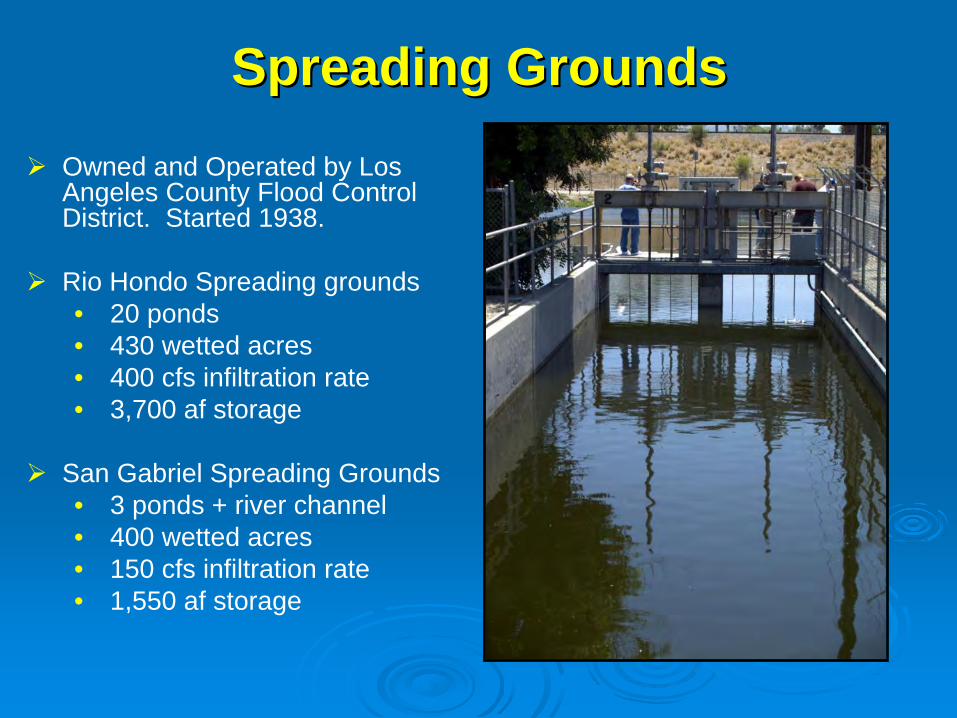
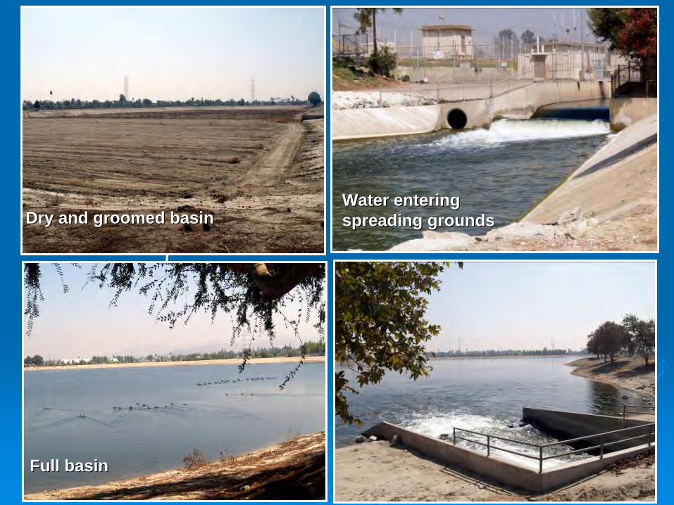
Managed aquifer recharge utilizing captured storm water has been practiced in the Montebello Forebay region of the Central Basin since 1938, when the Rio Hondo and San Gabriel Coastal Spreading Grounds were opened by the Los Angeles County Flood Control District (LACFCD). These facilities receive controlled releases of precipitation from upstream dams in addition to uncontrolled runoff from the San Gabriel River, Rio Hondo Channel, and their tributaries. The Rio Hondo facility has 430 wetted acres with 20 shallow ponds that percolate on average 400 cubic feet per second (cfs) and can hold a maximum of 3,700 acre feet (af). The San Gabriel facility has a spreading grounds and an unlined river channel. The spreading grounds are 96 wetted acres with 3 shallow ponds that percolate on average 75 cfs and can hold up to 550 af. The unlined river channel, which utilizes inflatable rubber dams to contain the water, is 308 wetted acres and can also average a 75 cfs infiltration rate with a storage capacity of 1,000 af. Imported water (starting in 1953) and recycled water (starting in 1962) are also spread at these facilities, and together with the storm water provide the supplemental groundwater recharge necessary to make-up the pumping overdraft in the Central Basin. Since 1938, a total of 7,335,063 af have been recharged at these two facilities, including 2,895,086 af of storm water (39%), 1,510,880 af of recycled water (21%) and 2,929,098 af of imported and other makeup water (40%). The Water Replenishment District of Southern California (WRD) buys the imported and recycled water for recharge to help maintain the reservoir supply. However, the availability of imported water for recharge is becoming more limited due to drought and judicial constraints. Surplus seasonal water WRD has relied upon for nearly 50 years has not been available since May 2007. Additionally, the price of imported water continues to rise. In April 2007, the price to WRD was $285/af. In January 2011 it will be $495/af if seasonal water is available or $638/af if it is not. As a result, WRD and LACFCD have embarked on projects to capture more storm water to reduce the volume of imported water needed for groundwater recharge. Two new rubber dams built on the San Gabriel River capture an additional 3,600 af/year (afy). Infrastructure located behind the Whittier Narrows Dam was removed to increase the footprint of the water conservation pool and increase storm water recharge by another 3,000 afy, with the potential for 1,100 afy more. A pipeline was constructed between the two spreading facilities to enhance operational flexibility to capture another 1,300 afy. And, a new groundwater production facility in concept phase would lower the water table and allow capture of an additional 17,000 afy. Collectively, these innovative projects will capture enough new storm water to offset much of the imported water demand for groundwater recharge.
1 Water Replenishment District of Southern California, 562-275-4240, [email protected]
The Increasing Role of Storm Water The Increasing Role of Storm Water for Groundwater Recharge in the for Groundwater Recharge in the
Central Basin, Los Angeles Coastal Central Basin, Los Angeles Coastal Plain, Southern CaliforniaPlain, Southern California
Ted Johnson, Michael GaganTed Johnson, Michael GaganWater Replenishment District of Southern CaliforniaWater Replenishment District of Southern California
NWRI Managed Aquifer Recharge, January 26, 2011NWRI Managed Aquifer Recharge, January 26, 2011
USGS
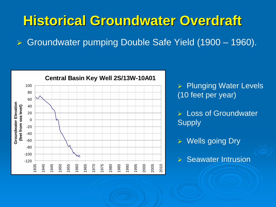
5,800% increase 5,800% increase in 100 yearsin 100 years
But LA is DryBut LA is Dry
Receives only 15 inches (38 cm) rainfall / yr.
Rivers are dry except after infrequent storms or wastewater treatment plant discharges.
San Gabriel River (typically dry)San Gabriel River (typically dry) Treated Sewage Effluent in San Gabriel RiverTreated Sewage Effluent in San Gabriel River
Imported River Water: From Northern California & Colorado River (majority).
Groundwater from wells that tap the local aquifers.
Recycled Municipal Wastewater: From local sewage treatment plants and water reclamation plants.
So Where does LA get its Water?So Where does LA get its Water?
San Gabriel ValleySan Gabriel Valley
Coyote Hills
Palos Verdes Hills
Puente Hills
Merced Hills
Santa Monica Mtns
Long BeachLong Beach
San Gabriel RiverLos Angeles River
Los Los AngelesAngeles
San Gabriel MtnsSan Gabriel Mtns
Pacific Ocean
Newport-Inglewood Uplift
Newport-InglewoodUplift
~2.5 Million People Area = ~270 mi2
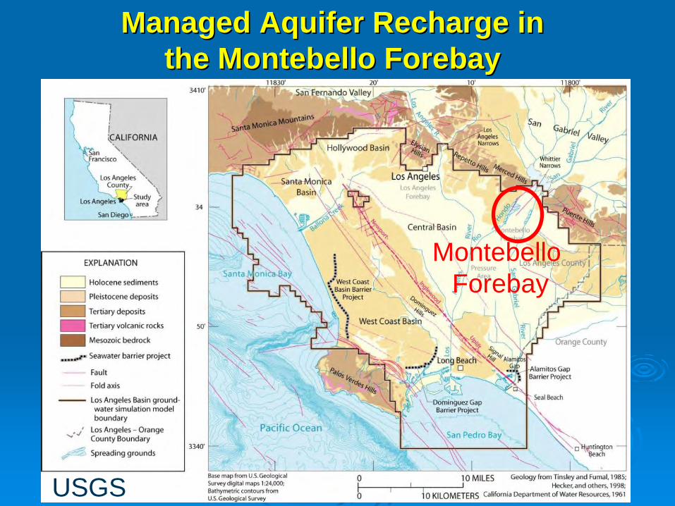
Focus on one basinFocus on one basin……The Central Groundwater BasinThe Central Groundwater Basin
E
E’
Geology of the Los Angeles BasinGeology of the Los Angeles Basin
USGS
Thick waterThick water--bearing sediments bearing sediments in the Central Basinin the Central Basin
Thick section of Late Pliocene to Recent water-bearing sediments (> 3,000 feet thick in some places).
Sediments deposited during active faulting and folding.
From Wright (1991)
Understanding of deep structure from 1000s of oil wells.
Central Basin
Aquifers
Over 300 Groundwater Production Over 300 Groundwater Production Wells Extracting over 200,000 afyWells Extracting over 200,000 afy
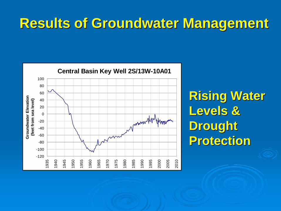
Results of Groundwater Management Results of Groundwater Management
Rising Water Rising Water Levels & Levels & Drought Drought ProtectionProtection
Current Challenges Current Challenges ……Loss of WRD historical Loss of WRD historical imported replenishment imported replenishment water due to drought, legal, water due to drought, legal, & environmental factors.& environmental factors.
Price for next level (Tier) of Price for next level (Tier) of imported water 29% higher imported water 29% higher ($638/af vs. $495/af).($638/af vs. $495/af).
Searching for other sources Searching for other sources for groundwater recharge.for groundwater recharge.
More recycled waterMore recycled waterConservationConservationMore storm water captureMore storm water capture
Dam up the river (temporarily)Dam up the river (temporarily)Inflatable rubber dams are Inflatable rubber dams are proven technology to halt proven technology to halt river flow and promote river flow and promote infiltration.infiltration.
2 new dams in 2008 in San 2 new dams in 2008 in San Gabriel River. Joint project Gabriel River. Joint project between WRD/LADPW.between WRD/LADPW.
3,600 3,600 afyafy more storm water more storm water capture and infiltration.capture and infiltration.
Project cost: $4.2 millionProject cost: $4.2 million
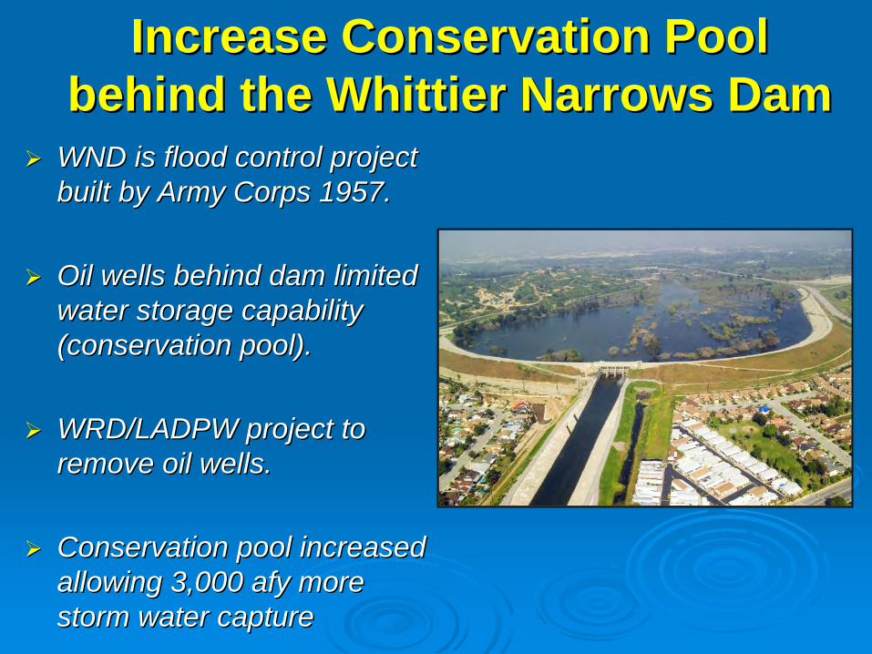
Increase Conservation Pool Increase Conservation Pool behind the Whittier Narrows Dambehind the Whittier Narrows Dam
WND is flood control project WND is flood control project built by Army Corps 1957.built by Army Corps 1957.
Oil wells behind dam limited Oil wells behind dam limited water storage capability water storage capability (conservation pool). (conservation pool).
WRD/LADPW project to WRD/LADPW project to remove oil wells.remove oil wells.
Conservation pool increased Conservation pool increased allowing 3,000 allowing 3,000 afyafy more more storm water capturestorm water capture
Interconnection PipelineInterconnection Pipeline
TwoTwo--way pipeline (78way pipeline (78””diamdiam, 1.2 mi) to divert , 1.2 mi) to divert flows between Rio Hondo flows between Rio Hondo and San Gabriel.and San Gabriel.
WRD/LACDPW project WRD/LACDPW project will go online March 2011. will go online March 2011.
Will increase storm water Will increase storm water capture by 1,300 capture by 1,300 afyafy, also , also more recharge flexibility.more recharge flexibility.
Cost $7.6 millionCost $7.6 million
Rio Hon
do
San
Gabr
iel
Create More Vadose ZoneCreate More Vadose Zone
Shallow water table limits Shallow water table limits storm water recharge. storm water recharge.
Concept to install pumping Concept to install pumping wells to drawdown water wells to drawdown water table, exposing more table, exposing more vadose zone, and freeing vadose zone, and freeing up more room for storm up more room for storm water capture / recharge.water capture / recharge.
Modeling shows 17,000 Modeling shows 17,000 afyafy more storm water can more storm water can be captured. be captured.
Set of approaches to reduce runoff Set of approaches to reduce runoff and pollutants from reaching surface and pollutants from reaching surface waterways, and promote recharge.waterways, and promote recharge.•• BioswalesBioswales
•• Porous PavementPorous Pavement
•• Dry wellsDry wells
•• Rain HarvestingRain Harvesting
•• Smart LandscapingSmart Landscaping
Elmer Avenue site, Elmer Avenue site, LA and SG Rivers LA and SG Rivers Watershed Council Watershed Council
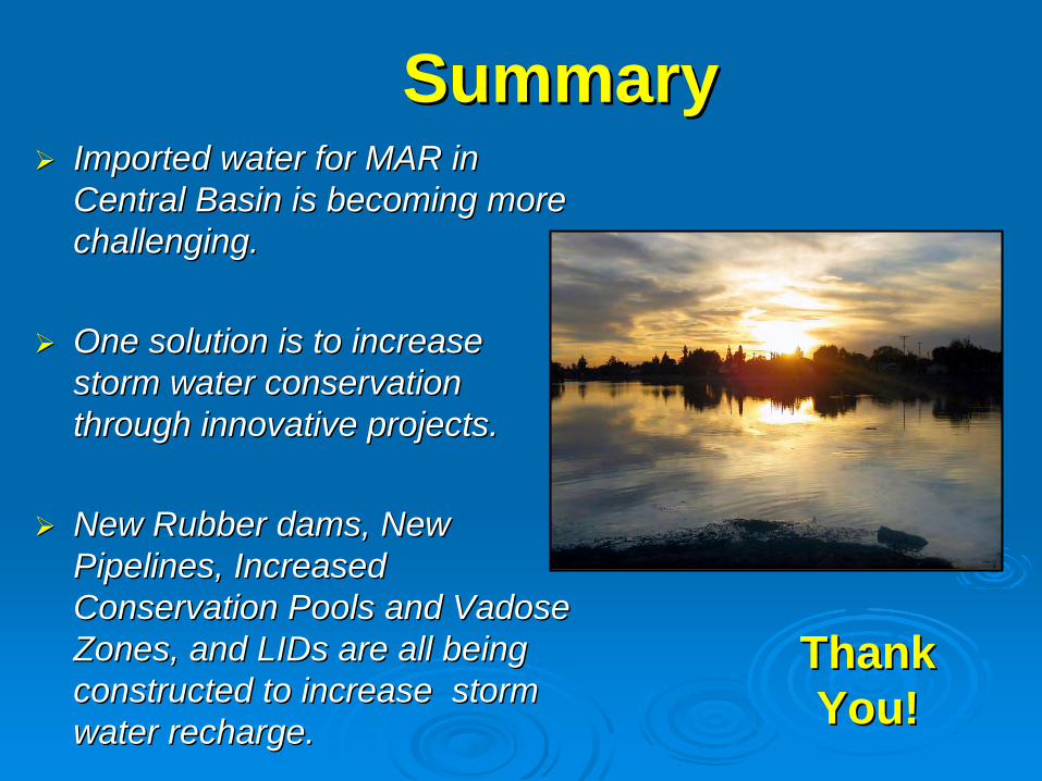
SummarySummaryImported water for MAR in Imported water for MAR in Central Basin is becoming more Central Basin is becoming more challenging. challenging.
One solution is to increase One solution is to increase storm water conservation storm water conservation through innovative projects.through innovative projects.
New Rubber dams, New New Rubber dams, New Pipelines, Increased Pipelines, Increased Conservation Pools and Vadose Conservation Pools and Vadose Zones, and Zones, and LIDsLIDs are all being are all being constructed to increase storm constructed to increase storm water recharge.water recharge.