1 The Institutional Framework for Urban Transportation and Land Use Planning and Management in the Globalizing Kuala Lumpur Region Zulina Zakaria 26 February 2003 EXECUTIVE SUMMARY Introduction and Purpose. Kuala Lumpur has been “groomed” to be the national node in “global networks” as Malaysia plugs into an emerging global information society and economy. The government, led by a progressive Dr. Mahathir Mohamed, has invested heavily in information and communications technologies (ICT) and transportation infrastructure to facilitate the country’s effort to achieve its vision of becoming a knowledge based economy and society. As the Kuala Lumpur area continues to experience rapid population and economic growth, it is expected that there will be a Kuala Lumpur Metropolitan Area (KLMA). Despite numerous investments in providing the means to alleviate urban traffic congestion, it is still a major problem for the city and the problem is expected to become worse as the city grows and merges with the surrounding urban areas. The main causes of traffic congestion were attributed to KLMA being a car-dependent, sprawled and has existing and future planned large scale urban development projects which are expected to increase the total vehicle trips within the city area by 40%. The Eighth Malaysia Plan has stated land use planning and Intelligent Transportation Systems some of the measures to alleviate urban congestion. For the KLMA, the Government will examine the reorganization and restructuring of the total urban transport operations with the objective of creating an efficient and financially sustainable system. The impact of globalization and the changes in socio-political and physical infrastructure have various policy implications and pose new challenges for urban transportation and land use system planning and management. Therefore, the purpose of this report is therefore to provide a preliminary account of the institutional framework and issues for both the transport and land use planning and management system. Existing Land Use and Transportation System. The KLMA encompasses five administrative districts of the Klang Valley (nine municipalities) and the Multimedia Supercorridor (MSC). The total population of the area in 1997 was 3.8 million and is expected to increase to 6.9 million in the year 2020. The area was estimated to have 1.45 million vehicles. The land use is mainly urban, functioning as centers for commerce, trade, industry and government. Currently, the KLMA has an extensive network of road and rail infrastructure to support public and private transportation modes. Traffic congestion is a major problem for the area (speed in radial roads at 10 km/hr) and private car usage is very high (80%). Socio-Economic Development Planning in Malaysia. The government functions as the planner for the national development. The National Planning Council (NPC) which is chaired by the Prime Minister is the highest authority in the formulation, coordination and decision making of economic and social development policies and programs in country. The private sector has an input at the NPC level. The Economic Planning Unit (EPU) acts as the secretariat to the NPC and hence is considered the most powerful and influential institution. For the state level development, the State Economic Planning Unit has the authority in the planning process. Land use matters are under state government control. Institutional Issues and Problems for Transportation Planning and Management. The transportation planning and management system is made of various public and private actors. In general, the Federal government is responsible for determining national transportation plans, transport policy guidelines and overall administrative matters. Local governments, on the other hand, plan, execute and administrate road networks and urban transport improvements under their jurisdiction. The issues and problems faced by these institutions include lack of coordination between institutions, insufficient capacity and capability to carry out planning at appropriate scales (e.g. local, regional and national), enforcement problems, problems with private sector “profit maximizing” interests, incentives by both government and private companies that promote private auto use. Institutional Issues and Problems for Land Use Planning and Management. The land use planning and management in Malaysia is in the realm of the local and state governments. The State Government provides general planning policies while the Local Authority is responsible for the detailed plans. The Federal Government does not have specific role in the planning of land use of States but it specifies that the preparation plans must take into consideration the needs and aspirations of the region and nation. The influence of the Federal Government is augmented by a variety of national plans prepared at the Federal level. The issues and problems that is has includes lack of capability for planning, shortage of manpower, coordination problems between state and local authorities, ineffectiveness of responsible organizations. Recommendations for future research. 1.) Creation of a regional land use - transport institution, 2.) ITS deployment and land use –transport mixed strategy for sustainable transport system in the MSC, 3.) Development of a policy analysis framework for evaluation land use-transportation interactions and environmental, economic and societal impact, 4.) Defining “sustainable transportation system” for Malaysia, 5.) Role of ISO 14000 Environmental Management System Standard, 6.) Improving the public- private partnership in transportation planning and management outcomes, 7.) Enhancement of public transportation usage.
Transcript
1
The Institutional Framework for Urban Transportation and Land Use Planning and Management
in the Globalizing Kuala Lumpur Region
Zulina Zakaria 26 February 2003
EXECUTIVE SUMMARY
Introduction and Purpose. Kuala Lumpur has been “groomed” to be the national node in “global networks” as Malaysia plugs into an emerging global information society and economy. The government, led by a progressive Dr. Mahathir Mohamed, has invested heavily in information and communications technologies (ICT) and transportation infrastructure to facilitate the country’s effort to achieve its vision of becoming a knowledge based economy and society. As the Kuala Lumpur area continues to experience rapid population and economic growth, it is expected that there will be a Kuala Lumpur Metropolitan Area (KLMA). Despite numerous investments in providing the means to alleviate urban traffic congestion, it is still a major problem for the city and the problem is expected to become worse as the city grows and merges with the surrounding urban areas. The main causes of traffic congestion were attributed to KLMA being a car-dependent, sprawled and has existing and future planned large scale urban development projects which are expected to increase the total vehicle trips within the city area by 40%. The Eighth Malaysia Plan has stated land use planning and Intelligent Transportation Systems some of the measures to alleviate urban congestion. For the KLMA, the Government will examine the reorganization and restructuring of the total urban transport operations with the objective of creating an efficient and financially sustainable system. The impact of globalization and the changes in socio-political and physical infrastructure have various policy implications and pose new challenges for urban transportation and land use system planning and management. Therefore, the purpose of this report is therefore to provide a preliminary account of the institutional framework and issues for both the transport and land use planning and management system. Existing Land Use and Transportation System. The KLMA encompasses five administrative districts of the Klang Valley (nine municipalities) and the Multimedia Supercorridor (MSC). The total population of the area in 1997 was 3.8 million and is expected to increase to 6.9 million in the year 2020. The area was estimated to have 1.45 million vehicles. The land use is mainly urban, functioning as centers for commerce, trade, industry and government. Currently, the KLMA has an extensive network of road and rail infrastructure to support public and private transportation modes. Traffic congestion is a major problem for the area (speed in radial roads at 10 km/hr) and private car usage is very high (80%). Socio-Economic Development Planning in Malaysia. The government functions as the planner for the national development. The National Planning Council (NPC) which is chaired by the Prime Minister is the highest authority in the formulation, coordination and decision making of economic and social development policies and programs in country. The private sector has an input at the NPC level. The Economic Planning Unit (EPU) acts as the secretariat to the NPC and hence is considered the most powerful and influential institution. For the state level development, the State Economic Planning Unit has the authority in the planning process. Land use matters are under state government control. Institutional Issues and Problems for Transportation Planning and Management. The transportation planning and management system is made of various public and private actors. In general, the Federal government is responsible for determining national transportation plans, transport policy guidelines and overall administrative matters. Local governments, on the other hand, plan, execute and administrate road networks and urban transport improvements under their jurisdiction. The issues and problems faced by these institutions include lack of coordination between institutions, insufficient capacity and capability to carry out planning at appropriate scales (e.g. local, regional and national), enforcement problems, problems with private sector “profit maximizing” interests, incentives by both government and private companies that promote private auto use. Institutional Issues and Problems for Land Use Planning and Management. The land use planning and management in Malaysia is in the realm of the local and state governments. The State Government provides general planning policies while the Local Authority is responsible for the detailed plans. The Federal Government does not have specific role in the planning of land use of States but it specifies that the preparation plans must take into consideration the needs and aspirations of the region and nation. The influence of the Federal Government is augmented by a variety of national plans prepared at the Federal level. The issues and problems that is has includes lack of capability for planning, shortage of manpower, coordination problems between state and local authorities, ineffectiveness of responsible organizations. Recommendations for future research. 1.) Creation of a regional land use - transport institution, 2.) ITS deployment and land use –transport mixed strategy for sustainable transport system in the MSC, 3.) Development of a policy analysis framework for evaluation land use-transportation interactions and environmental, economic and societal impact, 4.) Defining “sustainable transportation system” for Malaysia, 5.) Role of ISO 14000 Environmental Management System Standard, 6.) Improving the public-private partnership in transportation planning and management outcomes, 7.) Enhancement of public transportation usage.
2
INTRODUCTION Since the 1990s, the Malaysian government has been implementing strategies and policies to meet the objectives of the nation’s Vision 2020. Malaysia hopes to become a knowledge based society and achieve developed nation status. The Kuala Lumpur city, located in the Klang Valley, is the nation’s center for political and commercial activities and it is rapidly undergoing a transformation from a federal capital to a national “node” in global networks (Bunnel and Barter, 2002). As seen in other developing megacities of the world, the skewed trend in population and economic agglomeration in the Kuala Lumpur area over the 1960-1990s period has resulted in the expansion of the urban area together with the inability of the area to cope with traffic congestion, housing and environmental problems (Lee, 1997). The impact of globalization and the changes in socio-political and physical infrastructure have various policy implications and pose new challenges for urban transportation and land use system planning and management. Problem Statement As the Kuala Lumpur area continues to experience rapid population and economic growth, it is expected that there will be a Kuala Lumpur Metropolitan Area (KLMA) (Bunnel and Barter, 2002). Good infrastructure has been and continues to be a major factor for the development of the Klang Valley area (Lee, 1996). Currently, the KLMA has an extensive network of road and rail infrastructure to support the public and private transportation modes. However, despite numerous investments in providing the means to alleviate urban traffic congestion, it is still a major problem for the city and the problem is expected to become worse as the city grows and merges with the surrounding urban areas. The 1997 Malaysian Highway Authority’s 1study concluded the following as the main causes of traffic congestion and those relevant to land use patterns are noted here:
§ The land use pattern in the KLMA is dispersed and the existence of high car ownership trends has created a car-driven society.
§ The suburban sprawl phenomenon has changed the residential land use of the city area into a dense business and commercial area which has resulted in heavy commuter trips in and out of the city (1,149,000 2pcu/day) especially in the early morning hours.
§ Excessive existing and future planned large scale urban development projects are expected to increase the total vehicle trips within the city area by 40% (Malaysian Highway Authority, 1999).
The current urban structure of the area generates high traffic demands of the area. These characteristics left unmanaged could lead to greater urban transport and other economic, social and environmental problems in the future. Land use patterns drive transportation demand both for passenger and goods. Therefore, it is important that the effort to alleviate urban traffic congestion consider land use issues in connection with the transportation system. Purpose of Report The Eighth Malaysia Plan (2001-2005) has stated the vital role of infrastructure in distribution of goods, people and services in attainment of the nation’s objective of economic growth with resilience. Efforts will be targeted on the need to have a more efficient, safe and comfortable public transport system to enable a modal shift from private car usage. In the urban transport sector, the strategy adopted is to continue concentrating on the development of an integrated, efficient and reliable urban transport system in the Klang Valley as well as other urban areas. Apart from infrastructural and traffic management measures such as demand management, upgrading of roads etc., the plan has emphasized land use planning as one of the measures to alleviate urban congestion. Specifically for the Klang Valley area, the Government has indicated that it will examine the reorganization and restructuring of the total urban transport operations with the objective of creating an efficient and financially sustainable system. The Government has also stated its plan to use Intelligent Transportation Systems to alleviate traffic congestion in the Klang Valley area (Economic Planning Unit, 2001).
The purpose of this report is therefore to provide a preliminary account of the institutional framework and issues for both the transport and land use planning and management system. First, an overview of the national socio-economic planning system is provided to put land use and transport system planning within the national planning context. Then, current transportation and land use system of the KLMA area is described. . The land use and transport planning and management system are then examined and the issues and problems of both system planning and management are set forth. Recommendations for further research are outlined at the end of the report with a focus on the opportunities and challenges to create a “sustainable transportation system” and communities.
1 The study on Integrated Urban Transportation Strategies for Environmental Improvement for Kuala Lumpur. The report was conducted in 1997. The study has also been referred to as the SMURT -KL study. The results of this study is currently confidential. 2 pcu = passenger car units
3
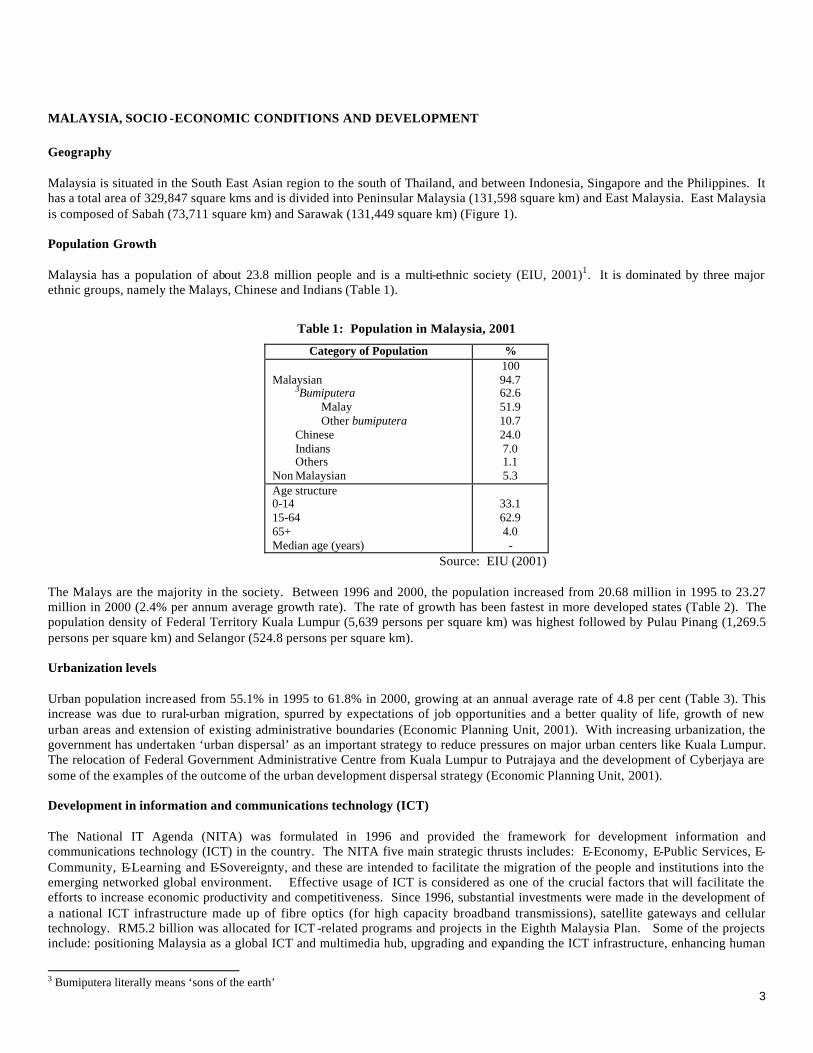
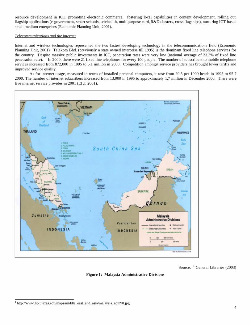
MALAYSIA, SOCIO -ECONOMIC CONDITIONS AND DEVELOPMENT Geography Malaysia is situated in the South East Asian region to the south of Thailand, and between Indonesia, Singapore and the Philippines. It has a total area of 329,847 square kms and is divided into Peninsular Malaysia (131,598 square km) and East Malaysia. East Malaysia is composed of Sabah (73,711 square km) and Sarawak (131,449 square km) (Figure 1). Population Growth Malaysia has a population of about 23.8 million people and is a multi-ethnic society (EIU, 2001)1. It is dominated by three major ethnic groups, namely the Malays, Chinese and Indians (Table 1).
Table 1: Population in Malaysia, 2001
Category of Population %
Malaysian 3Bumiputera
Malay Other bumiputera
Chinese Indians Others
Non Malaysian
100 94.7 62.6 51.9 10.7 24.0 7.0 1.1 5.3
Age structure 0-14 15-64 65+ Median age (years)
33.1 62.9 4.0 -
Source: EIU (2001) The Malays are the majority in the society. Between 1996 and 2000, the population increased from 20.68 million in 1995 to 23.27 million in 2000 (2.4% per annum average growth rate). The rate of growth has been fastest in more developed states (Table 2). The population density of Federal Territory Kuala Lumpur (5,639 persons per square km) was highest followed by Pulau Pinang (1,269.5 persons per square km) and Selangor (524.8 persons per square km). Urbanization levels Urban population increased from 55.1% in 1995 to 61.8% in 2000, growing at an annual average rate of 4.8 per cent (Table 3). This increase was due to rural-urban migration, spurred by expectations of job opportunities and a better quality of life, growth of new urban areas and extension of existing administrative boundaries (Economic Planning Unit, 2001). With increasing urbanization, the government has undertaken ‘urban dispersal’ as an important strategy to reduce pressures on major urban centers like Kuala Lumpur. The relocation of Federal Government Administrative Centre from Kuala Lumpur to Putrajaya and the development of Cyberjaya are some of the examples of the outcome of the urban development dispersal strategy (Economic Planning Unit, 2001). Development in information and communications technology (ICT) The National IT Agenda (NITA) was formulated in 1996 and provided the framework for development information and communications technology (ICT) in the country. The NITA five main strategic thrusts includes: E-Economy, E-Public Services, E-Community, E-Learning and E-Sovereignty, and these are intended to facilitate the migration of the people and institutions into the emerging networked global environment. Effective usage of ICT is considered as one of the crucial factors that will facilitate the efforts to increase economic productivity and competitiveness. Since 1996, substantial investments were made in the development of a national ICT infrastructure made up of fibre optics (for high capacity broadband transmissions), satellite gateways and cellular technology. RM5.2 billion was allocated for ICT -related programs and projects in the Eighth Malaysia Plan. Some of the projects include: positioning Malaysia as a global ICT and multimedia hub, upgrading and expanding the ICT infrastructure, enhancing human
3 Bumiputera literally means ‘sons of the earth’
4
resource development in ICT, promoting electronic commerce, fostering local capabilities in content development, rolling out flagship applications (e-government, smart schools, telehealth, multipurpose card, R&D clusters, cross flagships), nurturing ICT-based small medium enterprises (Economic Planning Unit, 2001). Telecommunications and the internet Internet and wireless technologies represented the two fastest developing technology in the telecommunications field (Economic Planning Unit, 2001). Telekom Bhd. (previously a state owned interprise till 1995) is the dominant fixed line telephone services for the country. Despite massive public investments in ICT, penetration rates were very low (national average of 23.2% of fixed line penetration rate). In 2000, there were 21 fixed line telephones for every 100 people. The number of subscribers to mobile telephone services increased from 872,000 in 1995 to 5.1 million in 2000. Competition amongst service providers has brought lower tariffs and improved service quality.
As for internet usage, measured in terms of installed personal computers, it rose from 29.5 per 1000 heads in 1995 to 95.7 2000. The number of internet subscribers increased from 13,000 in 1995 to approximately 1.7 million in December 2000. There were five internet service provides in 2001 (EIU, 2001).
Political background Political parties are mostly based on ethnicity, locality or religion. Trends in political milieu are the maintainence of racial harmony, positive discrimination in favor of bumiputra, and friction between Islamic parties and the government. Since the independence in 1957, the government has been led by the Barisan Nasional (BN or “National Front”) which is composed of United Malays National Organization (UMNO), Malaysian Chinese Association (MCA) and Malaysian Indian Congress (MIC). The BN is however dominated by the Malays. Opposition parties include the Democratic Action Parti (DAP), Parti Islam Se-Malaysia (PAS) and Parti Keadilan Malaysia (PKN). Recent events that might change the political landscape in Malaysia is the growing dominance of the coalition of the opposition parties. PAS has gained control of two states (Kelantan and Trengganu) in Malaysia and there are divisions within the Malay community. The retirement of Dr. Mahathir Mohamed, the Prime Minister, who has led Malaysia’s social and prosperous economic development (for alternative views see footnote 5)5 for 21 years (since 1981), is expected to bring big changes. However, the Prime Minister, despite his announcement to not seek any formal involvement in politics after his retirement, has said that he expected that his views will be sought. The next general election will be in November 2004 and the BN will be led by Dr. Mahathir’s current deputy and anointed successor, Datuk Abdullah Ahmad Badawi (The Strait Times, 2003)2. Current economic conditions and profile Despite the severe contraction in 1998 arising from the 6East Asian financial crisis, the Malaysian economy performed better than the expected 3% per annum growth rate at the end of year 2000. The economy had an average growth of 4.7% per annum from 1996-2000. The fiscal and monetary policies introduced in 1998 helped to stimulate consumption, while containing inflationary pressures and keeping unemployment levels low. In the year 2000, the services and manufacturing sectors contributed 52% and 33.4% respectively to the gross domestic product (GDP). The service sector is dominated mainly by three major sectors namely finance, insurance, real estate and business services; wholesale and retail trade, hotels and restaurants; and transport, storage and communication. These sub-sectors were not badly affected by financial crisis as there was continued government emphasis on information and communications technology (ICT) development. In addition, the expansionary monetary policy stimulated domestic spending and generated demand for intermediate and final services, in particular the finance, transport and communications sub-sectors. The manufacturing sector is dominated by the electrical and electronics products industry (more specifically semi-conductors and electronic machinery, and telecommunications equipment). Transport equipment and metal products industries are expected to be developed further in the Eighth Malaysia Plan to take advantage of the 7market liberalization with the implementation of the 8Asean Free Trade Agreement (AFTA). Mining contributed 6.6% and agriculture contributed 8.7% of the total GDP in 2000 (Economic Planning Unit, 2001). Privatization and Transportation It is important to note that since 1983, the Government, considers privatization to be an essential part of the overall strategy in the country’s economic development which allows for decrease in public spending on costly projects. Apart from the privatization of the existing public services agencies such as the national airline, airport, port authorities, and power supply, the upgrading of existing roads and the construction of new highways and expressways have also been privatized. Private operators are allowed to construct, operate and maintain new roads and subsequently recover back the cost through the collection of tolls. This privatization scheme also allowed the Government to hand over sections of completed roads to private companies for upgrading and consequent maintenance over a concession period. There are many ways of privatization that have been considered by the government. For new projects, the Government is amenable to the idea of `Build-Operate-Transfer' or `Build-Operate-Own' or `Build-Transfer' models (Jabatan Kerja Raya, 2002).
5 Some critics have attributed Malaysia’s economic growth to the “developmentalist role of the state” which was achieved through Mahathir’s “authoritative” style of governance, and political patronage and abuses of power (Gomez and Jomo, 1999). 6 The crisis began in June 1997 – December 1997 and initially affected exchange rates and stock prices. The worst ten East Asian economies impacted were Thailand, Indonesia, Malaysia, Philippines, Singapore, Hong Kong and China. The most serious impact happened in 1998 when these countries experienced negative growth with the exception of Singapore, China and Taiwan. Malaysia experienced a drop in per annum economic growth from 7.8% in 1996 to -6.7% in 1998 to 4.9% in 1999 (Yu and Xu, 2001). 7 Malaysia is a member of ASEAN (Association of South East Asian Nations), APEC (Asia-Pacific Economic Cooperation) and EAEC (East Asian Economic Group). In May 2000, the Prime Minister Malaysia has called upon the ASEAN countries to allow Malaysia to defer until 2005 the scheduled reduction in import duties on motor vehicles (EIU, 2001). Recently in end of 2002, the prime minister announced that even though import duties will be lifted, other forms of market protection taxes will be imposed on imported vehicles. 8 AFTA will be created in 2003.
6
Table 2: Land Area, Population and Population Density of States in Malaysia as of 2000
Land Area
(km2)
aRegional Location
Population (‘000)
Population Density
(per km2)
c GDP (RM
Million)
c, GDP per capita
(RM) Malaysia 329,847 n.r. 23,274 71 209,269 14,584 More Developed States
Johor
18,987
Southern 2,740 144
23,425
13,954
Melaka 1,652 Central 636 385 6,148 15,723 Negeri Sembilan 6,644 Central 860 129 6,776 12,791 Perak 21,005 Northern 2,051 98 17,153 13,183 Pulau Pinang 1,013 Northern 1,313 1274 17,314 21,469 Selangor 7,960 Central 4,188 526 44,078 17,363 Federal Territory of Kuala Lumpur 243 Central 1,379 5676 25,968 30,727 Less Developed States
Kedah
9,425
Northern 1,650 175
9,087
8,918
Kelantan 15,024 Eastern 1,313 87 5,061 6,241 Pahang 35,965 Eastern 1,288 36 8,250 10,370 Perlis 795 East M’sia 204 257 1,362 10,820 Sabah 73,619 East M’sia 2,603 35 b14,947 b9,123 Sarawak 124,450 East M’sia 2,072 17 16,323 12,755 Terengganu 12,955 Eastern 899 69 12,746 22,994 Federal Territory of Labuan 92 East M’sia 76 827 n.a. n.a.
Source: Adapted from Economic Planing Unit (2001) and Department of Statistics (2002) a- Classified as in Mohd Yusof Kassim (1992) b – Includes FT of Labuan c – in 1987 prices
Table 3: Urbanization by State 1990-2005
State
Urbanization Rate (%)
Average Annual Growth Rate of Urban Population (%)
1995 2000 2005 7MP 8MP More Developed States Johor Melaka Negeri Sembilan Perak Pulau Pinang bSelangor Federal Territory of Kuala Lumpur
54.4 49.5 47.3 56.2 77.0 80.8 100.0
63.9 67.3 55.0 59.5 79.5 88.3 100.0
69.1 75.3 58.2 65.3 83.3 92.7 100.0
5.7 7.5 4.4 1.9 2.7 7.3 2.0
3.8 3.2 2.3 3.0 3.1 5.0 2.2
Less Developed States Kedah Kelantan Pahang Perlis aSabah Sarawak Terengganu
35.1 33.5 35.0 29.6 39.8 41.8 46.6
38.7 33.5 42.1 33.8 49.1 47.9 49.4
43.3 36.7 44.0 38.9 53.2 54.6 50.1
3.9 0.5 5.2 3.5 7.7 4.4 2.7
3.9 2.8 2.2 3.7 4.9 4.8 1.6
Source: Economic Planning Unit (2001)
a – includes Federal Territory of Labuan b – includes Federal Territory of Putrajaya
7
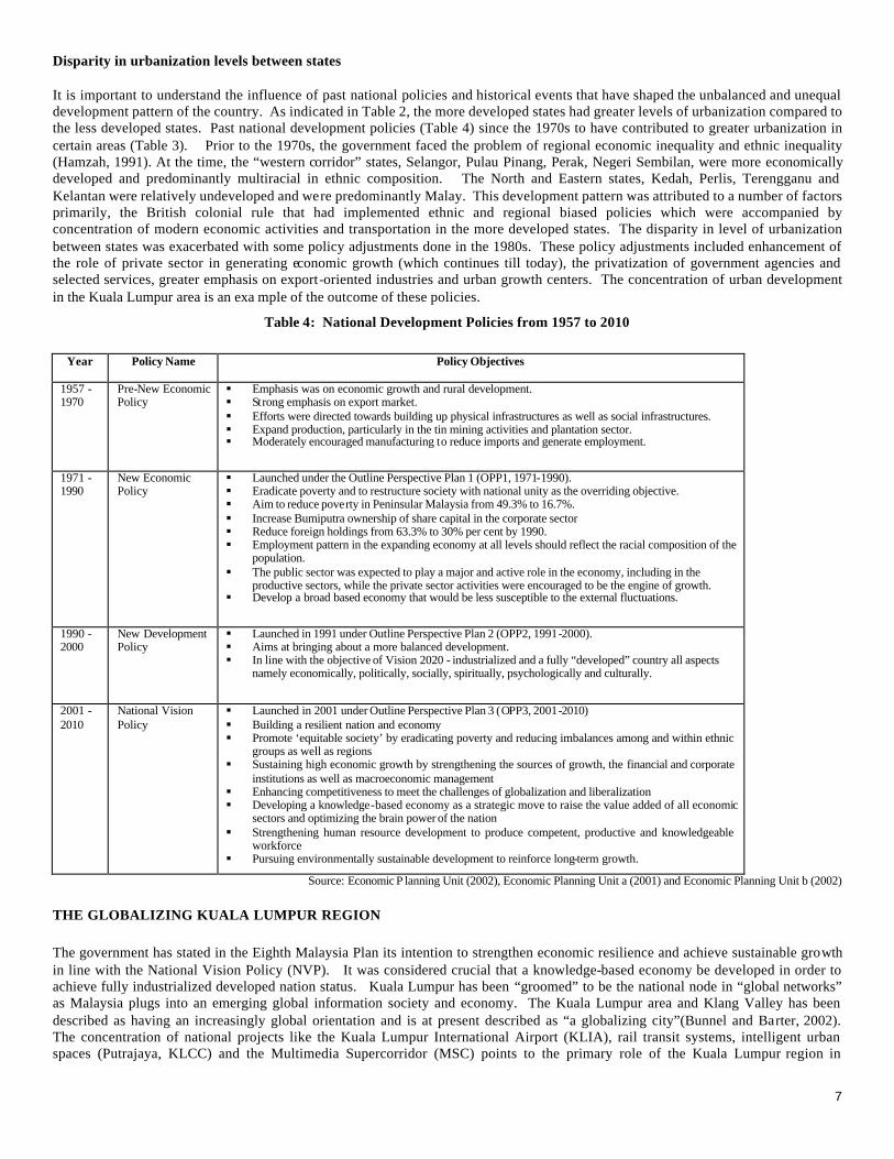
Disparity in urbanization levels between states It is important to understand the influence of past national policies and historical events that have shaped the unbalanced and unequal development pattern of the country. As indicated in Table 2, the more developed states had greater levels of urbanization compared to the less developed states. Past national development policies (Table 4) since the 1970s to have contributed to greater urbanization in certain areas (Table 3). Prior to the 1970s, the government faced the problem of regional economic inequality and ethnic inequality (Hamzah, 1991). At the time, the “western corridor” states, Selangor, Pulau Pinang, Perak, Negeri Sembilan, were more economically developed and predominantly multiracial in ethnic composition. The North and Eastern states, Kedah, Perlis, Terengganu and Kelantan were relatively undeveloped and were predominantly Malay. This development pattern was attributed to a number of factors primarily, the British colonial rule that had implemented ethnic and regional biased policies which were accompanied by concentration of modern economic activities and transportation in the more developed states. The disparity in level of urbanization between states was exacerbated with some policy adjustments done in the 1980s. These policy adjustments included enhancement of the role of private sector in generating economic growth (which continues till today), the privatization of government agencies and selected services, greater emphasis on export-oriented industries and urban growth centers. The concentration of urban development in the Kuala Lumpur area is an exa mple of the outcome of these policies.
Table 4: National Development Policies from 1957 to 2010
Year Policy Name Policy Objectives
1957 - 1970
Pre-New Economic Policy
§ Emphasis was on economic growth and rural development. § Strong emphasis on export market. § Efforts were directed towards building up physical infrastructures as well as social infrastructures. § Expand production, particularly in the tin mining activities and plantation sector. § Moderately encouraged manufacturing to reduce imports and generate employment.
1971 - 1990
New Economic Policy
§ Launched under the Outline Perspective Plan 1 (OPP1, 1971-1990). § Eradicate poverty and to restructure society with national unity as the overriding objective. § Aim to reduce poverty in Peninsular Malaysia from 49.3% to 16.7%. § Increase Bumiputra ownership of share capital in the corporate sector § Reduce foreign holdings from 63.3% to 30% per cent by 1990. § Employment pattern in the expanding economy at all levels should reflect the racial composition of the
population. § The public sector was expected to play a major and active role in the economy, including in the
productive sectors, while the private sector activities were encouraged to be the engine of growth. § Develop a broad based economy that would be less susceptible to the external fluctuations.
1990 - 2000
New Development Policy
§ Launched in 1991 under Outline Perspective Plan 2 (OPP2, 1991-2000). § Aims at bringing about a more balanced development. § In line with the objective of Vision 2020 - industrialized and a fully “developed” country all aspects
namely economically, politically, socially, spiritually, psychologically and culturally.
2001 -2010
National Vision Policy
§ Launched in 2001 under Outline Perspective Plan 3 (OPP3, 2001-2010) § Building a resilient nation and economy § Promote ‘equitable society’ by eradicating poverty and reducing imbalances among and within ethnic
groups as well as regions § Sustaining high economic growth by strengthening the sources of growth, the financial and corporate
institutions as well as macroeconomic management § Enhancing competitiveness to meet the challenges of globalization and liberalization § Developing a knowledge-based economy as a strategic move to raise the value added of all economic
sectors and optimizing the brain power of the nation § Strengthening human resource development to produce competent, productive and knowledgeable
workforce § Pursuing environmentally sustainable development to reinforce long-term growth.
Source: Economic P lanning Unit (2002), Economic Planning Unit a (2001) and Economic Planning Unit b (2002)
THE GLOBALIZING KUALA LUMPUR REGION The government has stated in the Eighth Malaysia Plan its intention to strengthen economic resilience and achieve sustainable growth in line with the National Vision Policy (NVP). It was considered crucial that a knowledge-based economy be developed in order to achieve fully industrialized developed nation status. Kuala Lumpur has been “groomed” to be the national node in “global networks” as Malaysia plugs into an emerging global information society and economy. The Kuala Lumpur area and Klang Valley has been described as having an increasingly global orientation and is at present described as “a globalizing city”(Bunnel and Barter, 2002). The concentration of national projects like the Kuala Lumpur International Airport (KLIA), rail transit systems, intelligent urban spaces (Putrajaya, KLCC) and the Multimedia Supercorridor (MSC) points to the primary role of the Kuala Lumpur region in
8
achieving the nation’s Vision 2020. The Multimedia Super Corridoor (MSC) requires special attention as it would be interesting to examine the implications of intelligent urban spaces on the transportation and land use system. Multimedia Supercorridor (MSC) The MSC was established in 1996 to drive the economy towards higher productivity via information technology and high value-added economic activities to catalyze the development of knowledge based economy. The area is planned to mimic the “technical virtuosity and economic dynamism” of the Silicon Valley in the United States (Bunnell, 2002a). Physically, the MSC is a 50 km long x 15 km wide area located in the Sepang district of Selangor. At the geographical core of the MSC are two intelligent cities: Putrajaya and Cyberjaya. Putrajaya is the new administrative center of Malaysia which makes use of sophisticated information technology for ‘electronic government’ (e-government). Cyberjaya is planned to be a technopole that will initia lly attract foreign information technology companies with the ultimate goal of stimulating the development of local ones (Bunnell, 2002).
The vision for the MSC is to become the global test bed for innovative solutions; the enabling infrastructure and incentives9 will be provided to attract leading global ICT companies10 to use the MSC as a hub as well as help create both local and foreign small and medium-sized enterprises. In addition, a set of cyberlaws was enacted to enable the factors for the development of ICT in the country. The main cycberlaw is the Communications and Multimedia Act 1998 primarily aimed at promoting deregulation, streamlining of licensing procedures and facilitate market liberalization. The MSC brings together three key elements to achieve its vision: § A high-capacity global telecommunications and logistics infrastructure built upon the MSC's 2.5-10 gigabit digital optical fibre
backbone and a massive, new KLIA international airport. § New policies and cyberlaws designed to enable and encourage electronic commerce, facilitate the development of multimedia
applications, and position Malaysia as the regional leader in intellectual property protection. § An attractive living environment in which careful zoning plans integrate infrastructure "mega-projects" with green reserves to
create environmentally friendly, "intelligent" urban developments. The Multimedia Development Corporation (MDC) was empowered to promote the overall development of the MSC. The MSC International Advisory Panel, comprising of policy makers, business leaders and academics, was also formed to steer the further development of the MSC. As of December 2000, there were 429 companies that have been accorded the MSC status. Among these companies area Microsoft, Oracle MSC, Hewlett Packard, Netscape, Ericsson, IBM, Lotus, Lucent Technologies, Intel MSC etc.
Administrative Districts, Urban Centers and Population Trends
The Kuala Lumpur Metropolitan Area (KLMA) (or more commonly referred to as Kuala Lumpur and its conurbation) is defined as the areas encompassing five administrative districts of the Klang Valley (nine municipalities) and the Multimedia Supercorridor (MSC) (Table 5 and Figure 2). The total population of the area in 1997 was 3.8 million and is expected to increase to 6.9 million in the year 2020 (Table 6). The area was estimated to have 1.45 million vehicles. Table 5 shows the major urban centers in the study area. The Federal Territory of Kuala Lumpur (FTKL), the capital of Malaysia, is the oldest and largest urban center with urban services. The city functions as the main economic, social and employment center for the country and thus attracts large volumes of traffic from its neighboring conurbation areas, sub-regional as well as regional centers. Some of the government offices like Ministry of Finance, Public Works Department still operate in the area even though most of government offices have moved to the new administrative center in Putrajaya. The Petaling District to the east of FTKL has three main urban centers; Shah Alam, Petaling Jaya and Subang Jaya. Shah Alam is the new state capital of Selangor and is a well planned urban center with services like state government offices, banking and manufacturing. Petaling Jaya was the main residential area for the Kuala Lumpur city back in the 1960s and now poses many urban functions like municipality services, recreation, industry, finance etc. The Klang district to the west of FTKL has one major urban municipal center which is Klang. Klang houses one of the largest port facilities in the country and an important import and export point for the Klang Valley. The seaport town functions mainly as a center for commerce, trade and industry. The Gombak district’s municipality is Gombak. It has urban functions like commerce, industry and wholesale.
9 The Bill of Guarantees of MSC status companies includes freedom of ownership, unrestricted employment of foreign knowledge workers, income tax exemptions, and freedom of sourcing capital globally. 10 Eligibility criteria for MSC Status: (1) must be a provider or a heavy user of multimedia products and services; (2) must employ a substantial number of knowledge workers; (3) must indicate a mechanism of transfer technology and/or knowledge to Malaysia, or otherwise contribute to the development of the MSC and the Malaysian economy.
9
The district of Hulu Langat has three main urban areas namely, Bangi, Kajang and Ampang Jaya. Bangi has two public universities (Universiti Putra Malaysia and Universiti Kebangsaan Malaysia) and houses several other private higher education institutions (UNITEN). Kajang is an old commercial center near Bangi. The Sepang district has two new municipalities, Putrajaya and Cyberjaya. The new Kuala Lumpur International Airport (KLIA) is located in the south of the district.
Table 5: Major Urban Centers and Functions in Kuala Lumpur Metropolitan Area
Districts
Urban Center
Administrative Status
Hierarchy of
Centers
Urban
Function Federal Territory Kuala Lumpur National capital National center Federal government, Commerce, Trade,
Banking, Offices, Wholesale, Health, Education.
Shah Alam State capital Regional center State government, Industry, Commerce Petaling Jaya Municipality Regional center Commerce, Industry
Petaling
Subang Jaya Municipality Sub-regional center Commerce Klang Klang Municipality Regional center Port, Industry, Commerce, Trade Gombak Selayang Municipality Regional center Industry, Wholesale, Commerce
Bangi Municipality Regional center Education, Commerce, Training Industry
Kajang Municipality Sub-regional center Commerce
Hulu Langat
Ampang Jaya Municipality Sub-regional center Commerce Putrajaya Federal Territory Sub-regional center Federal Government Sepang Cyberjaya Municipality Sub-regional center Research, Training, Education
Source: Malaysian Highway Authority (1999)
Table 6: Population Trends in Kuala Lumpur Metropolitan Area
Population in Millions
Districts 1997
2010
2020
Federal Territory 1.375 1.628 1.742 Petaling 0.833 1.189 1.402
Figure 2 : 11Districts in Selangor and the Federal Territory Kuala Lumpur
Existing Urban Transportation System
During the Seventh Malaysia Plan (1996-2000), the government had undertaken traffic demand management and introduced of various measures to encourage greater usage of public transportation to alleviate urban traffic congestion in the Klang Valley. Based on the recommendations of the 12Study on Integrated Urban Transportation Strategies for Environmental Improvement for Kuala Lumpur, measures which include restriction of on-street parking, one-way streets, differential parking, pedestrianization, bus lanes, contra-flow and restrictions on heavy vehicles entering the city center were implemented (Economic Planning Unit, 2001). Despite implementation of these measures, the speed of most radial roads in Kuala Lumpur is at 10 km/hour (comparable to Bangkok city) or less during morning peak hours due to high traffic volumes.
The following sections describe briefly the current state of the transportation system in the study area.
Road Network
The road network in the area is a combination of both ring and radial road system and ladder system. Kuala Lumpur has a ring and radial road system while the east-west corridor towards Klang and the south corridor towards KLIA have a ladder pattern (Malaysian Highway Authority, 1999). The road network is composed of many categories of roads ranging from expressway with full access control to urban highways with only partial access control, arterial and ring roads, distributors and access roads. The administrative and maintenance are done by various public institutions and private sector companies (Jabatan Kerja Raya, 1999). For example, toll expressways and toll highways (i.e. inter-urban toll expressways) are administrated by the Malaysian Highway Authority. Roads within Federal Territories are administered by the Federal Public Works Department and roads that are in the state are administered by the state Public Works Department. Traffic Movement The traffic movement of the area can be identified as corridors with 12 major access points into Kuala Lumpur. The southwest corridor, linking Kuala Lumpur, Petaling Jaya, Subang Jaya, Shah Alam and Klang, has the highest demand (170,000 -550,000 pcu/day). The next corridor with highest demand (410,000 pcu/day) is the south corridor linking Kuala Lumpur, the suburban areas of
11 (1) the Inner Core, comprising the Federal Territory of Kuala Lumpur; (2) the Primary Diffusion Corridor from Port Klang to Kuala Lumpur, which is the hub of industrial concentration in the country, including the Royal capital of Klang and the new towns of Petaling Jaya, and Shah Alam; and (3) an Outer Periphery, comprising such places as Rawang, Kuang, Batu Arang, Kapar, Banting, Telok Panglima Garang, Sepang, Salak, Dengkil, Ulu Langat, and Semenyih.
12 The report from this study is currently confidential and will be made public in 2004.
11
Puchong, Sri Kembangan, Bangi, KLIA and the Putrajaya/Cyberjaya Area. The traffic in this corridor is expected to increase very rapidly in the near future (Malaysian Highway Authority, 1999). Parking Lots A parking supply survey was undertaken in 1997 and the survey reported a total of 87,000 parking lots and a total of 76,000 lots of parking demand in the central Kuala Lumpur area. More than half of the parking lots are located in the Kuala Lumpur City Center (KLCC) area and Golden Triangle Bukit Bintang area (Malaysian Highway Authority, 1999). Public transportation Transportation studies conducted for the Klang Valley have indicated that the use of public transportation has been declining as the city grows in size. Table 7 and Figure 3 show the share of public and private modes of transportation in the study area. The private car and motorcycle mode shares have experienced a tremendous increase despite measures taken to increase public transportation usage.
Table 7: Share of Various Transportation Modes in the KLMA
Percent Share (%) Mode
1985 1997 Difference Car 33.8 42.9 +9.1 Motorcycle 13.8 18.0 +4.2 Stage Bus/Mini bus 17.69 6.0 -11.6 Factory Bus/School Bus 7.2 7.7 +0.5 Rail Based Transport - 1.2 -3.7 Non-motorized Transport (Walk and Bicycle) 27.6 23.9 +0.3 Other Modes - 0.3
Source: Malaysian Highway Authority (1999)
Bus system Bus services are made of up of stage buses operated by several private companies. The three major operators in the Kuala Lumpur, Petaling Jaya , Subang Jaya, Klang, Bangi and Selayang are Intrakota, Park May and Metro (the company which replaced mini buses). The Setapak/Wangsa Maju, Cheras and Taman Sri Damansara buses are operated by smaller bus operators such as Len Seng and Foh Hup. These bus services are suffering from the effects of traffic congestion and waiting time sometimes exceeds one hour. The service also has problems with overcrowding during peak hours and difficulty in bus transfers. There is also a problem of lack of discipline on the part of the bus operators and drivers in following the prescribed schedule and routes. All these problems have contributed to the decline in usage of the bus service (Malaysian Highway Authority , 1999).
Car43%
Other Modes0.3%
Non-motorized Transport (Walk
and Bicycle)24%
Factory Bus/School Bus
8% Rail Based Transport
1%
Stage Bus/Mini bus6%
Motorcycle18%
Figure 3: Share of Transport Modes in Klang Valley in 1997
Light Rail Transit There two Light Rail Transit (LRT) lines in the Kuala Lumpur area: the Putra LRT and the STAR LRT, which are operated by two distinct private operators. The STAR LRT and PUTRA LRT came into service in 1997 and 1998 respectively and the two lines has a total route length of 56 km. Passenger ridership on the STAR LRT increased from an average of 46,853 passengers per day (ppd) in 1997 to 77,803 ppd in 2000. As for the PUTRA LRT, the ridership in 1998 was 12,532 ppd and increased to 121,950 ppd in 2000
12
(Economic Planning Unit, 2001). Problems faced by the LRT lines are poor feeder bus service and the absence of physical and operational integration two LRTs lines (Malaysian Highway Authority, 1999) KTM Kommuter System The KTM (Keretapi Tanah Melayu) Commuter trains started operations in 1995 and the rail network extends from Rawang in the north to Seremban in the South, from Kuala Lumpur to Klang in to the west and Sentul to the northeast surburb covering a distance of 153 km. Feeder bus services are provided by the Park May bus company. The average daily ridership in 1997 was 43,000 passengers. Public Transport Terminal - KL Sentral The KL Sentral is a newly operational (in 2001) privatized public transport terminal integrating both the KTMB intercity and commuter services with the ERL, LRT PUTRA, Monorail, buses, taxis and pedestrian facilities. It does not however include the LRT STAR route in the terminal system. This transport terminal also provides an important link to the KLIA, Putrajaya and Cyberjaya (Economic Planning Unit, 2001). Taxi In 1997, there were a total of 11,275 registered taxis in Kuala Lumpur area and is operated by several management companies. It was found that the number of taxis per population in Kuala Lumpur is higher than those in Tokyo and Osaka (Malaysian Highway Authority , 1999). Taxi services are concentrated in the Kuala Lumpur area and are used only for short trips within the city.
INSTITUTIONAL FRAMEWORK FOR NATIONAL DEVELOPMENT PLANNING Since the 1950s, the government has assumed the function of development planner for the nation (Economic Planning Unit, 2002). The Economic Planning Unit (EPU), created under the Prime Minister's Department in 1961, was given the authority for development planning via inter-agency planning and monitoring mechanism. The EPU has a system of preparing medium to long terms plans to realize policies for national development. These plans also function as indicative plans for the private sector to understand and take action in a way appropriate with Government's economic policies and strategies for meeting the nation’s aspirations. Political-Administrative System Malaysia is a federal constitutional monarchy system of government. The country practices parliamentary democracy and the government is divided into three branches; the parliament (the legislative), the Cabinet (the executive) and the judiciary. The Federal Parliament consists of an upper chamber, the Senate (Dewan Negara) and a lower chamber, the House of Representatives (Dewan Rakyat). The upper chamber consists of members appointed by the king and elected by state legislators and the members of lower chamber are elected by universal suffrage. The lower house is currently dominated by the ruling Barisan Nasional. The Cabinet is a council of ministers appointed by the King with the advice of the Prime Minister.
The political-administrative organizational hierarchy in Peninsular Malaysia is shown in Figure 4. Malaysia has a three-tier type of government: federal, state and local government. The Federal Government is headed by the Prime Minister who chairs the Federal Cabinet. The State Governments are made up of State Executive Councilors (EXCO) and headed by the Chief Ministers who are elected politicians appointed by the Prime Minister. The EXCOs are appointed from members of the State Legislative Assemblies of respective states. Each state is then further divided into Districts under the administration of District Officers who are government servants under the direct responsibility of the State Secretaries. Each of the Districts is further divided into Local Authorities. The existence and powers of the Local Authorities are provided for by the Local Government Act 1976.
Under the current administrative hierarchy, the Federal Government is responsible for matters such as foreign affairs, defense and education. The State Government is responsible for religion and matters related to land use.
13
Source: Halimaton Saadiah (1994)
Figure 4: Political-Administrative Organizational Hierarchy in
Peninsular Malaysia
Hierarchy of Development Plans In accordance with the political-administrative hierarchy in Malaysia, the existing hierarchy of development planning system is shown in Table 8
Table 8: Hierarchy of Plans in the Planning System in Peninsular Malaysia
Administrative Level Plans Plan type Status National Outline Perspective Plan (OPP) Socio-economic Federal Five-year Development Malaysia Plan Socio-economic / sectoral
Political-administrative
State Economic Development Plan Socio-economic / sectoral State Economic Indicative Plan Socio-economic and spatial plan
State/Regional
Sub-regional Physical Plan
Administrative and ad hoc
District District Development Plan Development Project identification
Administrative
Structure Plan Strategic land use plan Local Local Plan Local land use plan
Mandatory under the Town and Country Planning Act 1976
Source: Halimaton Saadiah (1994)
Socio-economic plans and sectoral development plans are prepared at the federal, state and district levels. The federal plans form the basis for all other plans in the hierarchy. The state plans are ad hoc plans which mean they are produced administratively to guide development in the state or region. Next in the hierarchy is the district plan which is more formalized in planning but are still administrative in status. The only statutory plans are the local development plans, namely the Structure and Local plans which are legal documents under the 13Town and Country Planning Act 1976 (TCPA 1976).
Institutional Framework for Development Planning
Figure 5 shows the institutional framework for planning, coordination and evaluation for Malaysia.
13 Also referred to as Malaysia Act 172.
Federal Constitutional Monarchy Parliament headed by The King
Federal Government Cabinet headed by the Prime Minister
State Governments State Executive Councils headed by Chief Ministers
Districts Headed by Districts Officers
Local Authorities Councils headed by Presidents
14
Source: Economic Planning Unit (2002)
Figure 5: Planning, Coordination and Evaluation Machinery of the Federal Government
The National Planning Council (NPC) is the economic committee of the Cabinet and is composed of key economic ministers. The NPC is chaired by the Prime Minister and is the highest authority in the formulation, coordination and decision making of economic and social development policies in the country. Cooperating with the NPC in national level planning are the National Development Council (NDC), which considers matters on the implementation of the development programs and projects, and the National Security Council (NSC) that deals with security and natural disasters. The NPC is assisted by the National Development Planning Committee (NDPC). The NDPC, a committee of senior government officials chaired by the Chief Secretary to the Government, is responsible for formulating, overseeing the implementation of, and reviewing all development plans as well as making recommendations on the financial allocation for public sector projects. The EPU is the secretariat of the NDPC. Federal Level Planning
Planning at the Federal level is conducted by the central agencies through the Inter-Agency Planning Group (IAPG). The IAPG is composed of representatives from federal ministries, agencies and state governments, the EPU, the Public Services Department, the Implementation and Coordination Unit (ICU), and the Administrative and Modernization Unit (MAMPU) under the Prime Minister's Department, the Treasury and the Central Bank as shown in Figure 6. The EPU functions as the secretariat to the NDPC and its sub-committees namely the Estimates Sub-Committee, the Standards and Costs Sub-Committees and the various IAPGs. The overall public sector expenditure target and allocations according to the various sectors, ministries and states are approved by the Cabinet on the recommendation of the NDPC. Worth noting is the councils for improving the coordination between federal, state and local governments, three other national councils exists which are the National Council for Local Government (NCLG), the National Land Council (NFC), and the National Finance Council (NFC) (UNESCAP, 1995).
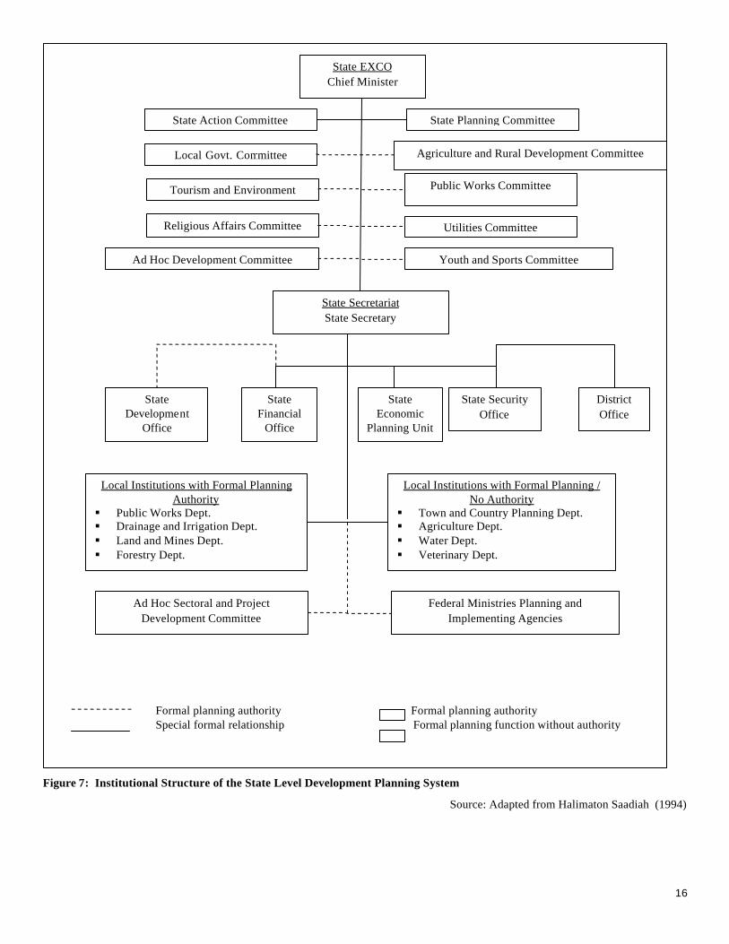
State Level Planning Figure 7 shows the state level development planning system. The State Economic Planning Unit (SEPU) has the responsibility of formulating the development strategy, coordination for the preparation of state development program and submits its plans for the Federal Government’s consideration after approval by the respective State Executive Committees (EXCO). Although directly responsible to the State Government, the SEPU work closely with Federal agencies, especially the EPU in the formulation and implementation of development programs and projects in their respective states.
Parliament
Cabinet
National Planning Council
National Development Council
National Security Council
National Development Planning Committee
National Development Committee
Economic Planning Unit Implementation
and Coordination Unit
15
Planning with the Private Sector
There is also planning for private-public partnership in the national planning system (Figure 6). Apart from input from various councils and committees like the Malaysian Business Council and the National Economic Consultative Council, private sector participation in achieved through dialogues conducted by the Treasury, the Ministry of International Trade and Industry and the Central Bank.
Source: Economic Planning Unit (2002) and Halimaton Saadiah (1994)
Figure 6: Institutional Structure of the National Level Development Planning System
Formal planning authority Formal planning authority Special formal relationship Formal planning function without authority
Cabinet Prime Minister
National Planning Council
National Finance Council
National Security Council
National Land Council
Minister of Finance Deputy Prime Minister
Prime Minister’s Dept. Chief Secretary to Federal Government
Minister with Special Functions Minister without Portfolio
National Development Planning Committee
Private Sector Economic Planning Unit
Ministries with Formal National Planning Authority § Ministry of Transport § Ministry of Agriculture § Ministry of Education
Ministries with Formal National Planning / No Authority
§ Ministry of Defense § Ministry of Rural Development § Ministry of Works § Etc.
National Council for Local Governments
Malaysian Business Council
Inter-agency Planning Group § Public Services Department § Implementation and Coordination Unit § Administrative and Modernization Unit § Treasury § Central Bank
16
Figure 7: Institutional Structure of the State Level Development Planning System
Source: Adapted from Halimaton Saadiah (1994)
Formal planning authority Formal planning authority Special formal relationship Formal planning function without authority
State EXCO Chief Minister
State Secretariat State Secretary
State Economic
Planning Unit
State Financial
Office
State Security Office
District Office
State Development
Office
Local Institutions with Formal Planning Authority
§ Public Works Dept. § Drainage and Irrigation Dept. § Land and Mines Dept. § Forestry Dept.
Local Institutions with Formal Planning / No Authority
§ Town and Country Planning Dept. § Agriculture Dept. § Water Dept. § Veterinary Dept.
State Action Committee State Planning Committee
Tourism and Environment Public Works Committee
Religious Affairs Committee Utilities Committee
Ad Hoc Development Committee Youth and Sports Committee
Local Govt. Committee Agriculture and Rural Development Committee
Ad Hoc Sectoral and Project Development Committee
Federal Ministries Planning and Implementing Agencies
17
INSTITUTIONAL FRAMEWORK FOR TRANSPORTATION PLANNING AND MANAGEMENT SYSTEM
The transportation planning and management system is made of various public and private actors. The issues and problems faced by the planning and management systems include lack of coordination between institutions, insufficient capacity and capability to carry out planning at appropriate scales (e.g. local, regional and national), enforcement problems, problems with private sector “profit maximizing” interests, incentives by both government and private companies that promote private auto use. The following describes in greater detail the background and issues for transportation planning and management system.
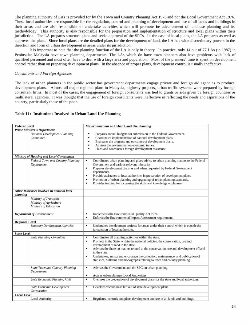
Transportation Institutions and Functions At present, a range of public and private institutions have responsibilities for transportation for the Kuala Lumpur Metropolitan Area. The details of the functions of the institutions listed above are presented in Table 9. It shows the federal, state and local administrative institutions involved in the urban transportation system 14(Prime Minister’s Department, 1999). 14Table 9: Institutions Involved with Urban Transportation System Management for KLMA
Federal Level Major Fu nctions on Urban Transport Prime Minister’s Department Economic Planning Unit § Formulates objectives, policies and strategies in development planning.
§ Plans the five-year development plans. § Coordinates and prepares the development budget for the five-year plans. § Coordinates the Privatization program.
Federal Territory Development and Klang Valley Planning Division
§ Coordinates development plans in the Klang Valley.
Ministry of Transportation Road Transport Department § Updates the revenue collection system.
§ Registers and license drivers of motor vehicles. § Ensures that motor vehicles are roadworthy. § Focuses on road safety issues and reduces the rate of road accidents. § Maintains records of information pertaining to motor vehicles and drivers.
Department of Railways § Controls fares and tariffs by examining all proposals for change in the structure and rates of fares, tariffs or charges submitted by any railway company.
§ Formulates regulations and prescribes minimum standards. § Ensures compliance of safety standards. § Enforces regulations (issuance, suspension and withdrawal of railways licenses,
etc.). § Studies proposals for new railway schemes and make recommendations for the
approval of the Minister. § Determines the performance standards of the services of the railway company
through statistical formats and reports.
Railways Asset Corporation § Administers and manages lands, properties and rights for railway services. § Develops infrastructure facilities for railway services.
Keretapi Tanah Melayu Berhad § Provides a modern, efficient and competitive railway system. Ministry of Finance § Responsible for urban transport related duties and taxation together with the
Ministry of Transport. Ministry of Works
Public Works Department § Plans, designs and constructs infrastructure projects, mainly roads, water supplies,
government buildings, airports, ports and jetties. § Operates and maintains roads, water supplies and certain Government buildings. § Provides technical advice to the Government at federal, state and district levels.
Highway Planning Unit
§ Conducts periodical traffic count surveys and issue an annual report on traffic volume.
§ Formulates national road and network system plan and program. § Assists state government and other agencies.
Malaysian Highway Authority
§ Supervises and executes the design, construction and maintenance of highways as determined by the Government.
§ Supervises and executes the design and construction of the rest and service areas and other facilities that may be deemed necessary along highways.
§ Collects toll from the users of the highways and other dues from the utilization of other facilities along the highways.
§ Plans and conducts research to ensure the efficient utilization and other facilities Ministry of Entrepreneur Development Commercial Vehicle Licensing Board § Processes and issue and licenses of all classes of commercial vehicles in
18
Peninsular Malaysia (including condition of licenses) § Determines the terms and conditions attached to all cases of commercial vehicle
licenses issued (fares, operation area, passenger capacity or type of goods, maximum load weight).
§ Formulates policies, roles and regulations pertaining to licensing of commercial vehicles, and monitor their impact on the efficiency of the road transport industry.
Ministry of Home Affairs Royal Malaysian Police § Maintains law and order. Local Level City Hall of Kuala Lumpur City Economic Planning Unit § Formulates policies and strategies on the Socio -Economic Development of the
Federal Territory of Kuala Lumpur. § Coordinates and monitors development projects § Manages all data and information on the development of Kuala Lumpur. § Ensures that infra-structure development and public facilities are planned and
implemented to promote urban economic activities such as property development, business, transport, finance tourism and others.
§ Ensures an integrated development of the industrial sector which will contribute to the urban economic growth.
Urban Transport Department § Coordinate and manage the implementation of the Monorail project and Light Rapid Transit (LRT) System in Kuala Lumpur and areas connected with it.
§ Plans and conducts research on the development of an urban transportation system that covers public and highway transportation system.
§ Designs and implements urban transportation projects financed by the government though City Hall Kuala Lumpur (bus/taxi stops, terminals for city buses and inter-town express buses and taxis)
§ Coordinates and manages public transport facilities and services financed by the government through City Hall Kuala Lumpur.
Public Works and Traffic Management Department
§ Plans, designs and implements road projects in the Federal Territory. § Coordinates with private agencies in the planning and development of road system
and traffic management in Kuala Lumpur City. § Improves on road designs and to increase road capacity to cater to the needs of the
increasing traffic volume. § Plans and implements traffic management schemes to improve traffic flow. § Maintains road networks to specific standards for the safety and comfort of road
users. § Minimizes road accidents. § Contribute towards a healthy environment, improve public transportation and
promote pedestrian traffic. Enforcement Directorate § Manage metered parking areas (privatized concept) and manual parking areas.
§ Controls and enforce traffic rules and regulations. § Conducts operations to eradicate illegal activities such as illegal car/motorcycle
attendants. Other Local Government Organizations § Similar to City Hall of Kuala Lumpur. Selangor State Municipalities of Selangor State
Source: Prime Minister’s Department (1999) Federal Level Institutions In general, the Federal government is responsible for determining national transportation plans, transport policy guidelines and overall administrative matters. Local governments, on the other hand, plan, execute and administrate road networks and urban transport improvements under their jurisdiction. Economic Planning Unit The Economic Planning Unit (EPU), under the Prime Minister’s Department, formulates the five-year Malaysia Development Plans. EPU’s 15Infrastructure and Utilities Section plans, evaluates and identifies the major transportation projects including urban transport development and makes the major investment decisions (Economic Planning Unit, 2002). Coordination for road and rail transport development planning for the KLMA is conducted by the Federal Territory Development and Klang Valley Planning Division. Ministry of Transportation The Ministry of Transportation is responsible for the general administration of land (excluding development of road and highways infrastructure), air and maritime modes of transportation. The Land Transport Division of the Ministry plans and formulates strategies for road and rail transport, reviews laws and rules of road and rail transport, monitors and coordinates the development of road transport, railway and light rail transit. More specifically, the Road Transport Department registers motor vehicles and issues driving 15 EPU’s organization comprises of 17 sections and two main divisions – the Macro Planning Division and the Sectoral Planning Division. The Infrastructure and Utilities Section is under the Sectoral Planning Division.
19
licenses. It also focuses on road safety issues and implements programs to reduce accident rates. The Department of Railway controls the fares and tariffs of rail operators, performs the technical evaluation of new railway projects as well as the issuance/withdrawal of licenses. The Keretapi Tanah Melayu Berhad is the provider of rail transport system. The Railway Asset Corporation administer and manages lands, properties and rights for railway services. It also develops the infrastructural facilities for railway services. Ministry of Works Three main divisions of the Ministry are involved in the land transport system. The Public Works Department plans, designs and constructs infrastructure projects including roads, airports, ports, jetties and public amenities. It also is the operator and maintains roads. It is the main advisor to the Government at federal, state and district levels on technical matters. The Highway Planning Unit is the planner of the national road network system. It als o carries out periodical traffic count surveys and issues annual reports on traffic volume. The Malaysian Highway Authority supervises and executes the privatization scheme for the design, construction, regulation, operations and maintenance of interurban highways (including toll expressways). Ministry of Entrepreneur Development The Ministry’s Commercial Vehicle Licensing Board processes and issue licenses of all commercial vehicles in Peninsular Malaysia. The Board determines the terms and conditions attached to all cases of commercial vehicle licenses issued (fares, operation area, passenger capacity or type of goods, maximum load weight). Ministry of Home Affairs The Royal Malaysian Police enforces traffic rules and regulations related to road traffic and traffic control. Local Government Level Institutions The local government institutions deal with daily urban transport problems and are responsible for the planning, construction and maintenance of transport facilities in their jurisdiction. The KLMA involves the City Hall of Kuala Lumpur and the municipalities in the Selangor state. The City Hall of Kuala Lumpur is governed by its own set of regulations and carries out its own planning, design, implementation and maintenance of road transport among other functions.
Functional Aspects of Institutions by Mode of Transport Table 10 summarizes the relationship between the abovementioned institutions and the mode of transport. The Economic Planning Unit is responsible for planning of all infrastructural facilities and modes of land transport. The Federal Territory Development and Klang Valley Planning Division major function is the coordination between institutions involved in public transportation and road and railway development. The Minis try of Transport covers the administration and safety aspects of all modes of transport except for road infrastructure which is under the control of the Ministry of Works. The Ministry of Entrepreneur Development is concerned only with the buses and taxis and is not concerned with the public railway services. The function of local government is very limited as the Federal government institutions determine the general plans and major government financed infrastructural projects. The local government is responsible only for the planning and development of smaller projects.
Ever since 16privatization was made a national policy in 1983, the private sector has been heavily involved in transport facility development projects. The private sector has been venturing into the upgrading of existing road and construction operation of new toll highways, expressways and railway. The government has been providing assistance in the form of soft or interest free loan and land acquisition assistance in project privatization schemes like “Build-Operate-Transfer”. In addition, bus stops, taxi stops and terminals have also been developed by the government as basic social infrastructure. The financial crisis of 1997 has forced the government to provide extensive assistance to privatized projects to ensure continuation of its construction (Economic Planning Unit, 2001).
16 The Federal Roads (Private Management) Act 1984 allows the Government to grant private companies the right to collect toll on public roads.
20
Table 10: Functions of Urban Transport Institutions by Transportation Mode
Infrastructure
Private Vehicles
Public
Transport
Traffic Rules Enforcement
Pedestrian Facilities
Parking Spaces
Institutions Road Railway Car and
Motorcycle Bus and taxis
Economic Planning Unit Investment Planning
Investment Planning
Planning Planning Planning
Federal Territory Development and Klang Valley Planning Division
Coordination Coordination Coordination
Ministry of Transport Licensing Supervising
Driving License Registration Vehicle Inspection
Driving License Vehicle Inspection
Traffic safety
Ministry of Works Planning Design Construction Maintenance
Ministry of Entrepreneur Development
License Route Fare control
Royal Malaysian Police Traffic control Enforcement
Control Enforcement
Local Government including City Hall of Kuala Lumpur
Planning Design Construction Maintenance
Coordination Bus/Taxi stop construction Bus terminals Bus lanes
Traffic control Enforcement One-way control
Planning Design Construction Maintenance
Control Enforcement
Private Sector Construction Maintenance Operation
Construction Maintenance Operation
Operation
Source: Adapted from the Prime Minister’s Department (1999)
Transportation Institutional and Management Problems Traffic flows in the KLMA crosses several local government jurisdictional boundaries. As of 1999, there is no proper government institution that effectively coordinates the overall regional development of the KLMA. The study conducted by the Prime Minister’s Department (1999) reported the following institutional and organizational problems:
Duplication and inappropriate allocation of implementation responsibilities between federal and local institutions There is inefficient allocation of responsibilities and duplication in the urban transport system management. For example, parking control regulation is duplicated by local governments and the Royal Police. Licensing and administration of fares and routes for public transportation is governed by the Commercial Licensing Board and not by the local governments which have better information on bus operations and traffic problems within its jurisdiction.
Lack of appropriate planning perspective and coordination at federal and local levels The federal level infrastructural planning institutions - Economic Planning Unit, the Ministry of Transport, Ministry of Works - have been planning from a national perspective instead of a regional perspective. The local governments, meanwhile, have been trying to coordinate their own projects with each other.
Even though there are institutions that are formed to coordinate development in the KLMA, it has not been effective. The Klang Valley Development Committee (KVDC) is responsible for the coordination of all development projects related to both state of Selangor and FTKL. The Federal Territory Development and the Klang Valley Planning Division (FTKVPD), under the Prime Minister’s Department has a similar role of KVDC. The report suggested that although the two institutions both function as coordinating bodies for common developments in the area, they are considered to have a national planning perspective instead of a regional planning perspective. There is probably a tendency to overlook the needs for regional development of the area. They are also considered to lack the capability to establish comprehensive regional plans. Lack of planning capability and capacity by local planning institutions
21
The study reported that the local governments do not collect and have the basic transport data and information and hence lack the capability and capacity to conduct transportation planning. For instance, no data is kept by the local governments as to the parking lot data, exact operation routes, and updated inventory and road network data. The local government does collect traffic volume data (via detectors at major traffic intersections) but without detailed vehicle type information which renders the data it less useful for transport modeling purposes. The local governments also lack town planners and transportation experts to plan a transportation system for their jurisdiction (Goh, 1997). Problems with the Build-Operate-Transfer (BOT) privatization scheme As noted previously, the transportation system in Malaysia has been undergoing privatization ever since 1983. The federal government is gradually changing its role as transport developer to supervisor of privately financed development projects. Many new toll highways and railway systems are currently being constructed and operated by private entities. The advantage of BOT scheme is that the government does not have to use limited funds for transport development. Nevertheless, there are problems that might occur under the scheme. For example, the private sector tends to only execute profitable projects and the resulting profits, which would otherwise be used for financing unprofitable vital projects, now accrues to the private sector and not the public. Another example is that badly needed public transport infrastructure might not be executed or delayed as they are less financially viable. Since the economic downturn, many BOT scheme projects have been increasingly abandoned and pose a burden to the government. Weak enforcement by responsible institutions Enforcement of transportation rules, regulations and operating conditions are very weak. For example, some of the scheduled stage bus services do not operate on schedule and sometimes are not operational at all. Buses frequently let passengers off at very busy roads and disrupt traffic flows. There was also a case whereby some feeder buses servicing the LRT stations were suspended because they were unprofitable routes. Lack of incentives to promote public transport system According to the study’s survey, more than 80% of trips are made by private modes. The share of public transport mode has been declining in tandem with the economic growth of the country and trend of increasing ownership of car and motorcycles. The study also found that the institutional aspects of private-public modal shares are biased to providing incentives for private car usage. For instance, more 90% of commuters who use the public transportation are not given commuting allowances but 75% of car users are given parking allowances.
INSTITUTIONAL FRAMEWORK FOR LAND USE PLANNING AND MANAGEMENT SYSTEM
The land use planning and management in Malaysia is in the realm of the local and state governments. The issues and problems that is has includes lack of capability for planning, shortage of manpower, coordination problems between state and local authorities, ineffectiveness of responsible organizations. Below is a description of the institutional framework for land use planning and management.
Legislation
The Town and Country Planning Act 1976 (TCPA 1976) is the main legislation that regulates land use planning in Peninsular Malaysia except for the Federal Territory of Kuala Lumpur (FTKL). The FTKL’s land use planning is regulated by the Federal Territory [Planning] Act 1982. Although there are differences in the administrative frameworks and mechanisms for development control, both Acts incorporate the structure plan system of planning. The TCPA 1976 covers 95 local authorities which are formed under the Local Government Act 1976. Land use planning, also called town and country planning in Malaysia, is lis ted under the ‘concurrent list’ of the Federal Constitution which means that the State can adopt all or only parts of the Act for implementation in their jurisdiction. Under the act, all local authorities are local planning authorities.
Development Planning System
Under the TCPA 1976, the State Government is given the responsibility to provide general planning policies while the Local Authority is responsible for the detailed plans. The Act does not provide the Federal Government any specific role in the planning of land use of States but it specifies that the preparation of local and structural plans must take into consideration the needs and aspirations of the region and nation. The influence of the Federal Government is augmented by a variety of national plans prepared at the Federal level (Goh, 1991). These plans include the five year Malaysia Plans, the Outline Perspective Plans, the Industrial Master Plan and the National Agricultural Policy.
22
Part III of the TCPA 1976 requires all local governments to prepare development plans for areas under their jurisdiction. A development plan is defined as a structure plan and one or more local plans for the whole or parts of the area. The following describes the principles of development plans: Structure Plan The preparation of the structure plan follows the process of ‘survey-analysis -proposal’. Surveys conducted include principle physical, economic, environmental, and social characteristics and land uses of the local and neighboring planning area; population; transport and communication systems; and any project changes that might have impacts on the planning or development of the area. The 17structure plan is defined in the TCPA 1976 as: “a written statement –
(a) formulating the policy and general proposals of the local planning authority in respect of the development and use of that land in that area, including measures for the improvement of the physical environment, the improvement of communications, and the management of traffic;
(b) stating the relationship of those proposals to general proposals for the development and use of land in the neighboring areas that may be expected to affect that area; and
(c) containing such other matters as they may be prescribed or as the State Planning Committee may particular specify” The policies and general proposals drafted must be justified by the results of the survey. The TCPA also introduced a formal system of public participation in the drafting of development plans. The first formal stage of public input is during the reporting of survey results and the second formal stage is during the review of the draft structure plan. Local Plan The TCPA defines a local plan18 as: “a map and a written statement which:
(a) formulates, in such detail as the local planning authority thinks appropriate, its proposals for the development and use of land in the area of the local plan, including such measures as the local planning authority thinks fit for the improvement of physical environment, the improvement of communications, and the management of traffic; and
(b) contain such matters as may be prescribed or as the State Planning Committee may in particular case specify” The local plan is produced for the entire or part of the local planning authority area and it mu st be consistent with the approved structure plan. It interprets strategic and spatial implications of structure plans and presents the local and spatial implications of national objectives and polices for social and economic changes. It therefore provides the framework for resource allocation and financing of development projects.
Land Use Planning Institutions and Functions The TCPA 1976 or Act 176 specifies several functions to authorities which are directly involved in land use planning (Goh, 1991). The institutions involved are the Prime Minister’s Department, Ministry of Housing and Local Government, the State Authority, the State Planning Committee and the Local Authority (Table 11). Federal Level Prime Minister’s Department As stated before, the National Development Planning Committee (NDPC), based in the EPU of the Prime Minister’s Department, is the highest authority in the formulation of policies and programs in Malaysia. The EPU has a strong influence over development patterns and process; it not only has impacts in terms of Terms of Reference and selection of planning teams but also evaluation and approval of consultant’s reports. Ministry of Housing and Local Government The Minister, who is the chairman of the National Council for Local Governments, of the Ministry of Housing and Local Government provides the concurrence to the adoption of the Act by the State authority. The Federal Town and Country Planning Department
(FTCPD) is officially responsible for the coordination urban planning in Peninsular Malaysia. The FTCPD also prepares guidelines and standards for urban development planning. Department of Environment The Department of Environment (DOE) is an important institution which can influence the direction of urban development planning. Proponents of certain types of activities, including land development, are required to submit an Environment Impact Assessment (EIA) report to the DOE. The DOE has also been preparing guidelines for environmentally sound development like the creation of open green spaces in urban development projects. A point worth noting is that there is confusion between the role of DOE and that of the FTCPD setting the planning standard and giving the final approval of EIAs reports. Regional Level Institutions Statutory Development Agencies Since the 1960s, the Federal Government has created various development agencies to carry out development projects. These agencies functions as implementing agencies and not planning agencies. Some of these agencies include the Urban Development Authority (UDA) and Regional development Authorities (RDAs) like the Trengganu Tengah Development Authority (KETENGAH). Some conflicts between regional and local have arisen in the past in areas where the jurisdiction of regional development agencies overlaps with local authorities. State Level State Authority The State Authority is responsible for the general policy with respect to the planning of the development and use of lands and buildings within the area of every local planning authority in the state. The State also sets up the State Planning Committee (SPC) which is given powers to direct any matters related to land use planning and development. The SPC is the institution which approves the structural plans. State Planning Committee (SPC) The SPC is most powerful institution next to the State Authority in the land use planning system. As mentioned before, it is the authority which approves structure plans prepared by local planning authorities. It is also responsible for the conservation, use and development of land in the state and promoter of the land use planning system and planning methodology. Town and Country Planning Department Functions as the secretariat to the SPC and acts as the principal agency for advising the Government and the SPC on the use and development of land including urban planning. Most often, the TCPD act as the urban planning department for Local Authorities. However, the number of planners in TCPDs is rather small. This situation entails problems where planners do not have adequate time to prepare their plans and reports or they have had to neglect large areas of the state even if population pressures demands that planning needs to take place. State Economic Planning Unit (SEPU) The SEPU is equivalent to the EPU at the Federal Level. Its main function is to assist the State Government to prepare socio-economic development plans and coordinate all socio-economic planning within the state. The SEPU has impact on the direction of urban development through its socio-economic development plans. State Economic Development Corporation (SEDC) The SEDC are state development implementing agencies and not planning agencies. It is chaired by the Chief Minister. These agencies are usually given large areas of vacant land (which are left out of development plans) to develop and are usually given the freedom to prepare their own development plans (e.g. new towns or industrial estates). The SEDC’s development plans may have to require approval from local authorities but as the case usually is, the local authorities are provided with a fiat accompli. Local Level Local Authority (LA)
24
The planning authority of LAs is provided for by the Town and Country Planning Act 1976 and not the Local Government Act 1976. These local authorities are responsible for the regulation, control and planning of development and use of all lands and buildings in their areas and are also responsible to undertake activities which will promote the advancement of land use planning and its methodology. This authority is also responsible for the preparation and implementation of structure and local plans within their jurisdiction. The LA prepares structure plans and seeks approval of the SPCs. In the case of local plans, the LA prepares as well as approves the plans. Since local plans are the detailed plans for the development of land, the LA has wide discretionary powers in the direction and form of urban development in areas under its jurisdiction. It is important to note that the planning function of the LA is only in theory. In practice, only 14 out of 77 LAs (in 1987) in Peninsular Malaysia have town planning departments. The LAs which do have town planners also have problems with lack of qualified personnel and most often have to deal with a large area and population. Most of the planners’ time is spent on development control rather than on preparing development plans. In the absence of proper plans, development control is usually ineffective. Consultants and Foreign Agencies The lack of urban planners in the public sector has government departments engage private and foreign aid agencies to produce development plans. Almost all major regional plans in Malaysia, highway projects, urban traffic systems were prepared by foreign consultant firms. In most of the cases, the engagement of foreign consultants was tied to grants or aids given by foreign countries or multilateral agencies. It was thought that the use of foreign consultants were ineffective in reflecting the needs and aspirations of the country, particularly those of the poor.
Table 11: Institutions Involved in Urban Land Use Planning
Federal Level Major Functions on Urban Land Use Planning Prime Minister’s Department National Development Planning
Committee
§ Prepares annual budgets for submission to the Federal Government. § Coordinates implementation of national development plans. § Evaluates the progress and outcomes of development plans. § Advises the government on economic issues. § Plans and coordinates foreign development assistance.
Ministry of Housing and Local Government Federal Town and Country Planning
Department § Coordinates urban planning and gives advice to urban planning matters to the Federal
Government and various relevant ministries. § Prepares development plans as and when requested by Federal Government
departments. § Provide assistance to local authorities in preparation of development plans. § Promotion of urban planning and upgrading of urban planning standards. § Provides training for increasing the skills and knowledge of planners.
Other Ministries involved in national level planning
Ministry of Transport Ministry of Agriculture Ministry of Education
Department of Environment § Implements the Environmental Quality Act 1974. § Enforces the Environmental Impact Assessment requirement.
Regional Level Statutory Development Agencies
§ Undertakes development projects for areas under their control which is outside the
jurisdiction of local authorities. State Level State Planning Committee § Coordinates all planning activities within the state.
§ Promote in the State, within the national policies, the conservation, use and development of land in the state.
§ Advises the State on matters related to the conservation, use and development of land in the state.
§ Undertakes, assists and encourage the collection, maintenance, and publication of statistics, bulletins and monographs relating to town and country planning.
State Town and Country Planning
Department § Advises the Government and the SPC on urban planning. § Acts as urban planners Local Authorities.
State Economic Planning Unit
§ Oversees the preparation of development plans for the state and local authorities.
State Economic Development Corporation
§ Develops vacant areas left out of state development plans.
Local Level Local Authority § Regulates, controls and plans development and use of all lands and buildings
25
§ Undertakes activities to promote the advancement of land use planning and its methodology.
§ Prepares and implements structure and local plans within their jurisdiction.
Source: Goh (1991)
Issues and Problems in Land Use Planning Shortage of urban planners and local plans at Local Authorities (LAs) One of the weaknesses of urban land use planning is the lack of development plans especially local plans (Goh, 1997). Even though most urban areas have structure plans, they are broad brush plans and do not provide the details of the plans. As mentioned before, the lack of urban planners in Local Authorities (LAs) may have contributed to this fact. In 1987, 63 out of 77 LAs do not have urban planners. The remaining 14 LAs with urban planners were far from adequate to perform their tasks. Ideally, there should be three planners at each LA: one for preparation of development plans, one for research and management and one for controlling development including processing of applications to undertake land development (Goh, 1991). There is also a problem of lack of funds for employing urban planners in LAs. Conflicting development plans between state implementing agencies and local authorities The lack of planners have resulted in development projects in many LAs undertaken without guidance of development plans. In some areas, the absences of local plans have created situations where there is conflicting development plans drafted by state implementing agencies like the RDAs and SEDCs. There was confusion as which agency has planning authority. It is advisable to not allow for areas that are left without development plans. Rudimentary state of land use planning in Malaysia The state of the art of urban planning is said to be at a rudimentary stage in Malaysia (Goh, 1997). It is assumed that capacity for planning at a regional level would also be lacking. In addition to that, even if urban planning expertise is obtained for LAs, not much is known about the Malaysian urban society which planners are supposed to plan for. Ineffective functioning of the FTCPD and TCPD The role and functions of the Federal and State Town and Country Planning institutions are being assumed by the EPU and the DOE. The Government has been increasingly turning to the EPU and DOE for assistance in the formulation of policies and strategies on urban development planning. The FTCPD and TCPD were suggested to clearly define its roles and functions as town planners (Goh, 1991).
Institutional Opportunities and Challenges for Transportation and Land Use Planning and Management The transportation and land use planning and management involves complex interrelationships between different public and private agencies at the local, regional, state, and federal government levels. The incorporation of environmental aspects and systems into the current picture would make the problems even more complex. It is useful to conduct stakeholder analysis and organizational process analysis to further understand the issues and the problems faced by the two systems with respect to integrated transportation-land use planning and management.
The current institutional framework for land use and transport system planning and management are already present but is not integrated in one institution. It is also experiencing problems with capacity and capability in many implementation issues like financial, manpower, and expertise. The Malaysian development planning through implementation of the local and structural plans have formalized urban planning for local and state authorities. The Federal Town and Country Planning Department has also issued sectoral guidelines for planning of land use and transportation system ( Federal Town and Country Planning Department, 2000). The Government has already created an institution to oversee the planning and development of the KLMA (Figure 8 and Table 12) (Mohd Ishak, 1989). From the information available, it seems that the institutional arrangement has included all the key institutions in the planning and management of both systems. However, it is doubtful that there is effective and efficient coordination at every link shown with the problems and issues facing the two systems. For the KLMA, it is recommended that further examination of the process of the land use and transport planning system be done in order to design regional development policies that could be operationalized though highly fragmented and multimodal structures of independent groups and organizations in both public and private sectors.
Conclusion and Further Areas for Research
26
This report has presented the background for the institutional framework and the organizations involved in transportation and land use planning and management in Peninsular Malaysia. The technical and institutional issues and problems of the two systems have also been described. Subsequently, this information will be used to further research work in identifying the opportunities and challenges for the development and implementation of “sustainable transportation systems” and “sustainable communities” in the KLMA which would require careful integration of technical, economic, organizational and political considerations. The following are potential research questions and information that is recommended:
1. Creation of a regional land use - transport institution.
Both the transportation and land use systems have serious institutional issues and problems which have affected the institutions from being effective and efficient. If there is an integration of the two land use and transportation system planning and management at the regional level for KLMA, these institutional issues and problems will be more pronounced as more private and public stakeholders will be involved. Should there be a new regional institution? If there should, how can the two institutions be integrated to effectively manage a sustainable transportation system? What is the organizational behavior (cultural, political and strategic) of the local, state and federal institutions of the two systems? What practical level of jurisdiction should it have (federal or district)? What are the funding sources of the new institution (gas tax, road tax, area pricing schemes etc.)? What are the capacity training needs for regional planning of a land-transportation system?
2. ITS deployment and land use –transport mixed strategy for sustainable transport system in the MSC
The KLMA’s MSC is envisioned as an intelligent urban region and the use of ICT is greatly promoted (politically and financially). What is the impact of the government proposed Intelligent Transportation System deployment in the MSC area? Could a “sustainable transportation system” with mixed implementation strategies in land use (mixed land use, transit development, infill development, jobs/housing balance, neotraditional designs etc.(U.S. EPA, 2000), transportation and ITS systems be created?
3. Development of a policy analysis framework for evaluation land use-transportation interactions and environmental,
economic and societal impacts.
The transportation and land use system could be regarded as a “CLIOS” - it is a complex, large and integrated, open-system (Sussman, 2000). There is yet a model that represents the land use-transport interaction for the KLMA. This model should be able to provide estimations of the potential environmental, economic and societal impacts of different combinations of urban land structure and transportation modes operating under different alternative political, economic and societal scenarios. For this purpose, the following will be needed among other relevant: § Inventory of local vehicle technologies and emissions § Inventory of vehicles § Emissions impact assessment model § Traffic data § Travel demand data § Detailed land use activity information
4. Defining “sustainable transportation system” for Malaysia
As stated before, part of the problem with urban planning in Malaysia is that there is not much information on what communities want as there is lack of public participation in the planning process. The government’s vision is that of a system that is “efficient” and financially sustainable. How does the public define “efficiency”? What are the “sustainability” objectives of the public? In other words, what does “sustainable transportation” and “sustainable communities” mean to a Malaysian?
5. Role of ISO 14000 Environmental Management System Standards
Apart from the Environmental Impact Assessment requirement for development projects, which has not been very effective, are there any other opportunity to incorporating environmental aspect considerations in the planning and management process of both transportation and land use systems? Is there a role for the voluntary 19ISO 14000 Environmental Management Systems Standards to achieve targeted environmental objectives amongst other objectives?
6. Improving the public-private partnership in transportation planning and management outcomes
19 The government has been forthcoming in the use of the ISO 14000 Environmental Management Systems for industries and government institutions. The ISO 9000 Management System standards have been created and implemented in many public and private organizations.
27
There are many problems with the current BOT privatization scheme for transportation infrastructure development and implementation. What incentive schemes could be used to improve the outcomes of the public-private partnerships in transportation systems?
7. Enhancement of public transportation usage
The share of public transport mode has been declining in tandem with the economic growth of the country and trend of increasing ownership of car and motorcycles. What strategies could used to enhance the public transportation usage? What are the causes of this trend?
28
Source: Mohamed Ishak (1989)
Figure 8: Legislative and Political Administrative Decision-Making in the
Planning System in Peninsular Malaysia
Coordination Recommendation goes up for approval
National Development Planning Committee
(NDPC)
Klang Valley Regional Planning Council
Klang Valley Regional
Development Committee
Klang Valley Planning
Secretariat
State Planning Unit
Federal Territory Planning Unit
State Secretary
Secretary General
EXCO Minister
State Departments and
Agencies
Area Task Forces
Sector Task Force
Federal Departments
29
Table 12: Composition of Klang Valley Planning and Development Institutions
Entities in the Institutional Framework
Chairperson Federal Representation State Representation Functions
Klang Valley Regional Planning Council
Chair: Prime Minister
Deputy: Chief Minister of Selangor
Minister for the Federal Territory
Chief Secretary to the Government Mayor of Kuala Lumpur Chief Secretary to the Ministry responsible for Federal Territory
State Secretary
Two members from the State EXCO Director of State Planning Unit Director State Town and Country Planning Department
§ Determine policies and strategies as well as coordinate all planning and development in the Klang Valley.
§ Approve and issue a regional perspective plan, a regional strategy map and development plan.
§ Consider planning development applications of strategic significance before their determination by the competent authority.
§ Review and monitor implementation of plans approved by the council.
§ Consider all other matters of regional significance.
Klang Valley Regional Development Committee
Joint chairmanship by State Secretary of Selangor and Chief Secretary responsible for Ministry of Federal Territory.
Director of Planning, City Hall of Kuala Lumpur
Director of Lands, Mines, Federal Territory Principal Assistant Secretary of Planning and Research
Director of State Town and Country Planning Department
Director of State Economic Planning Unit
Director of Lands and Mines, Selangor
§ Considers all reports from the state government, Federal Territory and the Klang Valley Planning Secretariat.
§ Makes recommendations to the Regional Planning Council.
Klang Valley Planning Secretariat
A unit established under the Prime Minister’s Department
Federal Territory Planning Unit
Federal Departments
State Planning Unit
State departments and agencies
§ Act as a secretariat to the Klang Valley Planning Co uncil under the direction of the Regional Development Committee
§ Monitors, reviews and assesses the implementationand development in the Klang Valley based on the regional plans approved.
§ Formulates policies and
strategies for the consideration and approval of the Klang Valley Planning Council
Source: Mohd Ishak (1989)
30
REFERENCES Bunnel T (2002) Cities for nations? Examining the city-nation-state relation in information age Malaysia. International Journal of
Urban and Regional Research. 26.2: 284-298. Bunnel T (2002a) Multimedia utopia? A geographical critique of high-tech development in Malaysia’s Multimedia Super Corridor.
Antipode. 34(2): 265-295(31). Bunnel T and PA Barter (2002) City profile Kuala Lumpur metropolitan area, a globalizing city region. Cities. 19: 357-370. Department of Statistics (2000) Census 2000. http://www.statistics.gov.my/English/framesetPressdemo.htm Economic Planning Unit (2001) Eighth Malaysia Plan 2001 – 2005 . Economic Planning Unit: Putrajaya. Economic Planning Unit a (2001) The Third Outline Perspective Plan 2001 – 2010. Economic Planning Unit: Putrajaya. Economic Planning Unit b (2002) Development Planning in Malaysia. Economic Planning Unit: Putrajaya. EIU (2001) Malaysia Brunei Country Profile. New York: The Economic Intelligence Unit. Federal Town and Country Planning Department (2000) Total Planning and Development Guidelines. Federal Town and Country
Planning Department, Ministry of Housing and Local Government. Goh Ban Lee (1991) Urban Planning in Malaysia: History, Assumptions and Issues. Tempo Publishing: Petaling Jaya. Goh Ban Lee (1997) Land use planning in Malaysia. In: Land Issues in Malaysia. Consumer’s Association of Penang: Penang. Gomez ET and KS Jomo (1999) Malaysia’s Political Economy- Politics, Patronage and Profits. Cambridge: Cambridge University
Press. Halimaton Saadiah Hashim (1994) Integrating Strategic Environmental Assessment into Malaysian Land Use Planning . PhD.Thesis
University of Newcastle Upon Tyne, United Kingdom. Hamzah Jusoh (1991) The application of Williamson’s hypothesis to regional development in Malaysia. In: Regional Development
in Malaysia Issues and Challenges. (Ed) Mohd Yaakub Haji Johari. Institute for Development Studies (Sabah) : Kota Kinabalu.
Jabatan Kerja Raya (1999) Malaysia Roads General Information 1999. Jabatan Kerja Raya (Public Works Department), Ministry of Works.
Jabatan Kerja Raya (2002) http://www.jkr.gov.my/jln/hari-jkr/Road4.htm Lee Boon Thong (1996) Emerging urban trends and the globalizing economy in Malaysia. Mega-city Growth and the Future, Second
Edition. United Nations University Press: Tokyo. Malaysian Highway Authority (1999) Study on Integrated Transport Information System (ITIS) in Klang Valley and the MSC in
Malaysia. Malaysian Highway Authority: Kajang Mohamed Ishak (1989) Decentralization of Metropolitan Functions: The Malaysian Experience with particular emphasis in the
Klang Valley Region. Paper presented at the IFHP International Congress 1989, Chiba, Japan. 13-17 November 1989. Mohd Yusof Kassim (1992) Regional Development in Malaysia: A Review of Past and Present Policies. In: Regional Development
in Malaysia Issues and Challenges. (Edited by). Mohd Yaakub Hj. Johari. Institute for Development: Kota Kinabalu. Prime Minister’s Department (1999) A Study on Integrated Urban Transportation Strategies for Environmental Improvement in Kuala Lumpur,
Final Report, Volume II. Prime Minister’s Department: Putrajaya. (currently confidential until 2004) Scientific. <http://www.wspc.com.sg/books/economics/4534.html>
Sussman, J (2000) Sussman, J (2000) Introduction to Transportation Systems. Artech House: Norwood. the MSC in Malaysia. Malaysian Highway Authority: Kajang.
The Strait Times (Feb 20, 2003) Dr M to quit govt, party posts on retirement. < http://straitstimes.asia1.com.sg/> U.S. EPA (2000) Improving Air Quality Through Land Use Activities. EPA Transportation Air Quality Center, U.S. EPA. UNESCAP (1995) Local Government in Asia and the Pacific. United Nations Economic and Social Commission for Asia and the
Pacific. http://www.unescap.org/huset /lgstudy/country/malaysia/malaysia.html#cat Yu, Tzong-Shian and Dianqing Xu (2001) From Crisis To Recovery : East Asia Rising Again? Ontario: World