28
The Integrated Geospatial Information Framework THE GUYANA EXPERIENCE

The Integrated Geospatial Information Framework
THE GUYANA EXPERIENCE

Sources:*Bureau of Statistics, 2020 est.; **The World Bank, April 2020
•Population: 750,000*
•Official Language: English
•Total Area: 215,000 km²
•Traditional Economic Base:• Agriculture
• Forestry
• Mining
• Emerging Oil Economy
• On a Green State Development Trajectory
• Real GDP Growth:** 4.7% (2019)
• Projected 51.7% (2020)
Cooperative Republic of Guyana
Source: GLSC, 2020

IMPLEMENTING IGIF: THE GUYANA EXPERIENCE
1. MILESTONES ON THE JOURNEY TO IGIF DEVELOPMENTA. Overview of Key Milestones
B. Refocused Mandate of National Geospatial & Mapping Agency - GLSC
C. Mainstreaming SLDM Project – Assisted with funding, partnerships, capacity building, technical support for IGIF
D. National Geospatial Information Policy – Aligned to Overarching Strategic Framework
E. NSDI Road Map – Expression of IGIF Country Level Action Plan
2. IMPLEMENTING IGIFA. Implementation Status
B. Reflections

1. MILESTONES ON THE JOURNEY TO IGIF DEVELOPMENTTHE GUYANA EXPERIENCE

A. OVERVIEW OF KEY MILESTONES ON GUYANA’S ROAD TO IGIF• April 2016- Refocus of NMGA (GLSC) mandate begins under new leadership
• June 2017 – GLSC becomes National Focal Point for UNGGIM. Consistentparticipation in UNGGIM Events and Expert Groups (FELA)
• 2018 – Operationalisation commenced for 4-year GRIF /UNFAO enabledMainstreaming SLDM Project
• June 2018 - Formulation and alignment of National GI Policy with IGIF (withECLAC support)
• August 2018 – Began re-establishment of National GNSS CORS Network (withOS)
• Jan 2019 – Adoption of NSDI Road Map: Expression of an IGIF Country LevelAction Plan (under SLDM Project)
• 2019 - International first-hand exposure to NSDIs and best practices withingeospatial sector through study tours to Jamaica, Cayman Islands, UK (OS,Geovation, Geospatial Commission), Netherlands (Dutch Cadastre, UoT), Serbia(RGA), Italy (UNFAO).
• March 2020 – GLSC Board of Directors approves National GI Policy
August
2018

B. REFOCUSING MANDATE OF GUYANA’S NATIONAL MAPPING AND GEOSPATIAL AGENCY
LEGAL MANDATE• The Guyana Lands and Surveys
Commission (GLSC) was formed in June 2001 through the GLSC Act 1999.
• Under the GLSC Act 1999, GLSC is mandated “To have charge of and act as guardian over all public lands, rivers and creeks of Guyana”
• There are 20 mandated functions in the GLSC Act
SUMMARY OF MANDATED FUNCTIONS• National Mapping and Geospatial
Agency
• National Surveying and Cadaster Authority
• National Public Land Administration Agency (Land Tenure administration, Land Use Planning, Land Development, Land Valuation)
• Lead liaison Agency among land agencies
• Advisor to Government on geospatial related Policy
• NSDI Lead Agency
NATIONAL FOCAL POINT
Since 2003
Since 2017
Since 2019
NEW LEADERSHIPIn April 2016, Mr. Trevor L. Benn was appointed CEO and Commissioner of Lands & Surveys and focused on urgently transforming the GLSC to deliver on its wide mandate as Guyana’s NMGA.

C. Mainstreaming Sustainable Land Development and Management (SLDM) Project
Indicative Project OutcomesOutcome 1: Sustainable Land
Development and Management (SLDM)
Mainstreamed In Policy, Institutional and
Governance Mechanisms to Prevent
Degradation and Restore Degraded Lands
Outcome 2: Strengthened Institutional
and Human Capacity for Participatory and
Integrated SLDM
Outcome 3: Local Governance
Strengthened in 3 Regions for
Implementing SLDM
Executing Agency on behalf of the
Government of Guyana
Implementing Partner
Source of Financing: Performance-based payments
for avoided deforestation under the Guyana REDD+ Investment
Fund (GRIF)
Project Period: Mid 2017- Mid 2021
(4 years)
Activities related to NSDI identified under this Outcome as mechanism for SLDM

• July 3-5, 2018 ECLAC Workshop in Georgetown - Towards a National Geospatial Framework and Policy in Guyana
• 5th draft iteration of a National GIS Policy was reviewed using the IGIF Overarching Strategic Framework
• National Policy on Geospatial Information was formulated and subsequently approved by the GLSC Board of Directors in early 2020.
D. The National Geospatial Information PolicyVISION: To promote the efficient use of geospatial information to effectively measure, monitor and achieve sustainable
social, economic and environmental development for current and future generations in Guyana.

National GI Policy Alignment with IGIF
STRATEGIC PATHWAY 1: GOVERNANCE AND INSTITUTIONS
� Executive Summary -Social and
Economic Business Case [p.4]
� Introduction – Rationale [1.2]
� Context [2.0]
� GLSC: for “visionary management
and technical leadership” (in
keeping with GLSC Act 1999 / Cap.
59:05)[3.1.3]
� Government of Guyana: for
political endorsement, to
encourage collaboration and
provide incentives to national
geospatial stakeholders [3.1.4-6]� Public, Private and NGO
Sectors: to provide
appropriate access to
geospatial data along clear,
fair guidelines and
mechanisms [3.1.5-6;3.9.5-7]
� Geospatial Advisory
Committee and Technical Sub-
Committees [4.0]
� NSDI Unit [3.1.2]
� Periodic creation of 5-
year National GIS
Strategy [3.1.8]
National GI Policy Alignment with IGIF
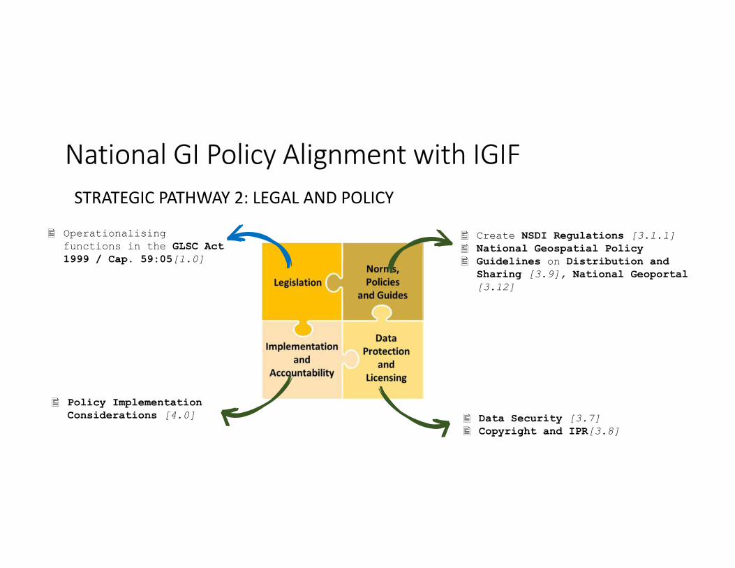
STRATEGIC PATHWAY 2: LEGAL AND POLICY
� Data Security [3.7]
� Copyright and IPR[3.8]
� Create NSDI Regulations [3.1.1]
� National Geospatial Policy
� Guidelines on Distribution and
Sharing [3.9], National Geoportal
[3.12]
� Policy Implementation
Considerations [4.0]
� Operationalising
functions in the GLSC Act
1999 / Cap. 59:05[1.0]
National GI Policy Alignment with IGIF
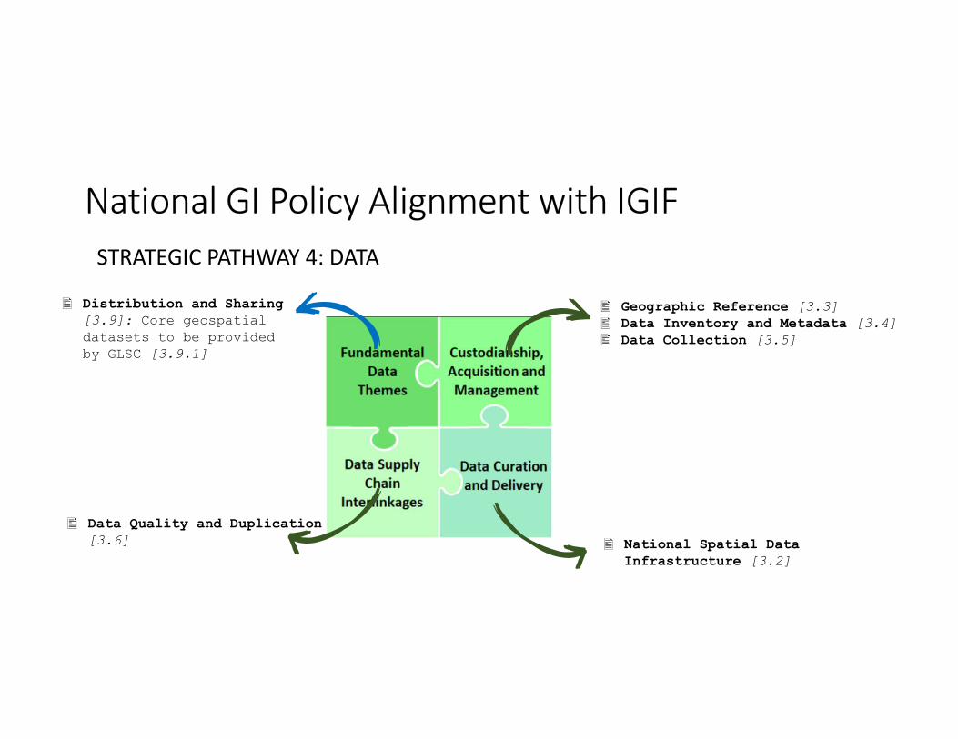
STRATEGIC PATHWAY 4: DATA
� National Spatial Data
Infrastructure [3.2]
� Geographic Reference [3.3]
� Data Inventory and Metadata [3.4]
� Data Collection [3.5]
� Data Quality and Duplication
[3.6]
� Distribution and Sharing
[3.9]: Core geospatial
datasets to be provided
by GLSC [3.9.1]

National GI Policy Alignment with IGIF
STRATEGIC PATHWAY 8: CAPACITY AND EDUCATION
� Collaboration among GLSC,
Ministry of Education, University
of Guyana for professional Geo-
informatics education and
training [3.13.2]
� Government to facilitate
development of human resources to
manage and operate geospatial
systems [3.13.1]
� Collaboration between GLSC,
Ministry of Education for GIS in
School Education Programs
(students and teachers) [3.13.3]
� GLSC to spread awareness
among non-traditional
users, build spatial
literacy among general
public [3.13.4]

E. IGIF COUNTRY ACTION PLAN: NSDI DEVELOPMENT ROAD MAP
• Developed under the Mainstreaming SLDM Project, Approved by UNFAO & GLSC in January 2019 following highly consultative and review period (5 months).
• This document presents an Action Plan, based on the IGIF Overarching Strategic Framework, for development of a National Spatial Data Infrastructure (NSDI) for Guyana over a 5-year period and outlines its socio-economic benefits.
• The implementation of the Action Plan will require an indicative level of investment of US$7.8m for the 5-year period.
• It is a living document!
• 80 pages
• Guyana is one of the first countries globally to start implementing the UNGGIM IGIF

Methodology to Develop NSDI Road Map: IGIF Country-Level Action Plan(UNGGIM, World Bank, UNFAO)
• Step 1: Baseline Assessment - NSDI Current State Diagnostic
• Step 2: Impact Assessment - NSDI Alignment to Government Policy Drivers, NSDI Socio-economic Analysis, NSDI Action Plan
• Step 3: Investment and Implementation- Plan of Action against timelines and costs for implementation

2. IMPLEMENTING IGIFTHE GUYANA EXPERIENCE (AS OF MAY 2020)

The Starting Point
50
33
42
371921
35
26
0
10
20
30
40
50
60
70
80
90
100
Policy & Strategy
Governance
Arrangements
Legal
Accessibility and
Technical
Socio-economic
Capacity
Development
Innovation and
Partnership
Core Data
Output from NSDI Diagnostic Tool from UNGGIM / World Bank Assessment Methodology, January 2019
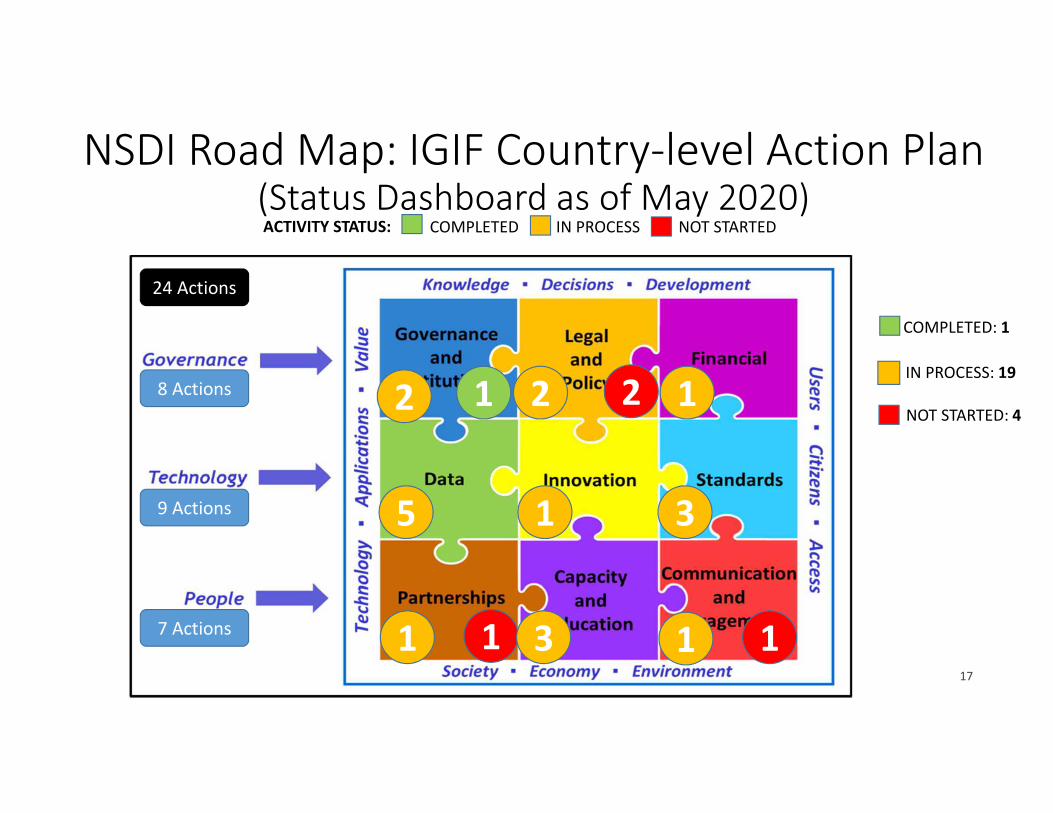
NSDI Road Map: IGIF Country-level Action Plan (Status Dashboard as of May 2020)
17
COMPLETED
D
IN PROCESS NOT STARTEDACTIVITY STATUS:
2 1
1
22
5 31
1 3 11
8 Actions
9 Actions
7 Actions
24 Actions
COMPLETED: 1D
IN PROCESS: 19
NOT STARTED: 41

NSDI / IGIF ACTION PLAN: STATUS (MAY 2020)
� Approval of National Geospatial
Information Policy (High Priority)
� Establish Geospatial Advisory
Committee (GAC) (High Priority)
� Establish Working Groups
(Medium Priority)
� Geospatial Policy (approval
within 3 months)
� GAC and working groups
established and operational
within 6 months
COMPLETE
D
IN PROCESS NOT STARTEDACTIVITY STATUS:
KPIsActions
Strategic Pathway 1:
Governance & Institutions

Strategic Pathway 2:
Policy and Legal Actions
• Update Land Surveys legislation to support cadastral upgrading
• Create Data Sharing Agreement (High Priority)
• NSDI Regulations (Medium Priority)
• Data Protection and Pricing and Licensing (Low Priority)
� Update Land Surveys
legislation within 12 months.
� Data sharing agreement in
place and regular operational
sharing between 5
organisations within 12
months.
� Regular operational sharing
between all major
stakeholders within 3 years.
KPIs
NSDI / IGIF ACTION PLAN: STATUS (MAY 2020)COMPLETE
D
IN PROCESS NOT STARTEDACTIVITY STATUS:
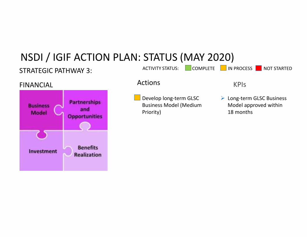
STRATEGIC PATHWAY 3:
FINANCIAL Actions KPIs
� Develop long-term GLSC
Business Model (Medium
Priority)
� Long-term GLSC Business
Model approved within
18 months
NSDI / IGIF ACTION PLAN: STATUS (MAY 2020)COMPLETE
D
IN PROCESS NOT STARTEDACTIVITY STATUS:

Strategic Pathway 4: Data Actions
• Create National Discovery Geoportal (High Priority)
• Rationalise State Land Leasing Process (Very high Priority)
• Create National Topographic Database (High Priority)
• Create a single National Street Address Database (High Priority)
• Hardware, Network and Software Needs to Support NSDI (Very High Priority)
� Discovery Metadata database populated with data from 10 key suppliers and openly accessible on the web within 6 months.
� Rationalise State Land Leasing process including new software live within 2 years.
� National street address database operational within 2 years.
� National coverage of updated topographic base mapping within 5 years.
KPIs
NSDI / IGIF ACTION PLAN: STATUS (MAY 2020)COMPLETE
D
IN PROCESS NOT STARTEDACTIVITY STATUS:

Strategic Pathway 5: Innovation
Actions
• Guyana Centre of Excellence for Geospatial Information(High Priority)
� Centre of Excellence terms of
reference, funding and
recruitment plans approved
by GAC within 12 months
� Centre of Excellence fully
operational within 2 years.
KPIs
NSDI / IGIF ACTION PLAN: STATUS (MAY 2020)COMPLETE
D
IN PROCESS NOT STARTEDACTIVITY STATUS:

Strategic Pathway 6: Standards Actions
• Development and implementation of standards policy (High priority)
• Discovery Metadata
• Base Mapping / National Topographic Database
• Addressing
� Street Addressing
content standard agreed
with 12 months.
� Content standards for 10
fundamental data
themes agreed within 3
years.
KPIs
NSDI / IGIF ACTION PLAN: STATUS (MAY 2020)COMPLETE
D
IN PROCESS NOT STARTEDACTIVITY STATUS:

STRATEGIC PATHWAY 7:
Partnerships
Actions KPIs
� Define Scope of a Partnership
with International NSDI
Organisations
� Support creation of Guyana
Association for Geospatial
Information
� Study visits to two countries completed
within 12 months.
� Guyana Association of Geospatial
Information formed within 2 years
NSDI / IGIF ACTION PLAN: STATUS (MAY 2020)COMPLETE
D
IN PROCESS NOT STARTEDACTIVITY STATUS:

Strategic Pathway 8:
CAPACITY & EDUCATION Actions
• Consolidate National Geospatial and Land Administration Capabilities at Tertiary Level (High Priority)
• Geospatial Information in the School Curriculum (Medium Priority)
• Foster Geospatial Entrepreneurship (Medium Priority)
� GIS Laboratory at
University of Guyana
opened within 12
months
� 3 new geospatial topics
within senior school
curriculum within 2
years
� Land management and
land valuation courses
graduating students
within 3 years
KPIs
NSDI / IGIF ACTION PLAN: STATUS (MAY 2020)COMPLETE
D
IN PROCESS NOT STARTEDACTIVITY STATUS:

STRATEGIC PATHWAY 9:
COMMUNICATION &
ENGAGEMENT
Actions KPIs
� Create Outreach Group
(High Priority)
� Monitoring and Evaluation
Framework (High Priority)
� Monitoring and Evaluation
framework approved by GAC within
6 months
� Outreach group staffed and
communications plan approved
within 12 months
NSDI / IGIF ACTION PLAN: STATUS (MAY 2020)COMPLETE
D
IN PROCESS NOT STARTEDACTIVITY STATUS:
Implementing IGIF: Reflections on Guyana’s Experience
Convergence of several strategic components made it possible for Guyana to become an early adopter and pioneer of IGIF:
1. Governance - Existing GLSC institutional structure with a legal, NMGA mandate led by a champion and with political support; financing from SLDM and GoG
2. People - Partnerships (e.g. UNFAO, UNGGIM, ECLAC, OS, UoT ITC, RGA), opportunities for capacity building (e.g. study tours, UNGGIM, World Bank, FIG fora)
3. Technology – the recognition and awareness that data, innovation and standards could be significantly improved within a IGIF approach (e.g. LiDAR, open source, FELA)

Kaieteur Falls
• Guyana Lands and
Surveys Commission
• Email:
• Website:
http://www.glsc.gov.gy
THANK YOU!


