e GEO Integrated Global Water Cycle Observations (IGWCO) Community of Practice (CoP) brings together data providers, scientists, resource managers, and other users from national and international governments, universities, and organizations that are interested in the application of water cycle data in the management of the world’s water on local, regional, and global scales. It also involves experts who are interested in the development of water cycle understanding, data products, and information systems; in the demonstration and assessment of the usefulness of these systems; in the dissemination of the results through capacity-building and technology transfer; and in the operational deployment of these systems and products, primarily through regional networks. e relationships among these elements are shown in Figure 1. Figure 1.e links between the components of the IGWCO CoP. THE INTEGRATED GLOBAL WATER CYCLE OBSERVATIONS (IGWCO) COMMUNITY OF PRACTICE INTRODUCTION TO THE IGWCO COMMUNITY OF PRACTICE
Transcript
The GEO Integrated Global Water Cycle Observations (IGWCO) Community of Practice (CoP) brings together data providers, scientists, resource managers, and other users from national and international governments, universities, and organizations that are interested in the application of water cycle data in the management of the world’s water on local, regional, and global scales. It also involves experts who are interested in the development of water cycle understanding, data products, and information systems; in the demonstration and assessment of the usefulness of these systems; in the dissemination of the results through capacity-building and technology transfer; and in the operational deployment of these systems and products, primarily through regional networks. The relationships among these elements are shown in Figure 1.
Figure 1.The links between the components of the IGWCO CoP.
THE INTEGRATED GLOBAL WATER CYCLE OBSERVATIONS (IGWCO) COMMUNITY OF PRACTICE
INTRODUCTION TO THE IGWCO COMMUNITY OF PRACTICE
2
The GEO IGWCO Community of Practice has its roots in the former Integrated Global Observation Strategy Partnership (IGOS-P) and the community that implemented the IGOS-P water cycle theme. In 2008, this group officially became the Group on Earth Observations (GEO) IGWCO Community of Practice. In the GEO context, it also fosters the development of broader global and regional networks that deal with science and applications issues.
The objectives of the GEO IGWCO CoP include:
1) Providing a framework for guiding decisions regarding priorities and strategies for the maintenance and enhancement of water cycle observations;
2) Promoting strategies that facilitate the acquisition, processing, and distribution of data products needed for effective management of the world’s water resources;
3) Coordinating and facilitating the inputs of the global water community and its user community into the Global Earth Observation System of Systems (GEOSS) plans and reports;
4) Fostering the development of tools, applications, and systems that facilitate the inclusion of water cycle information in decision-making.
The GEO IGWCO CoP provides leadership for many of the GEO Water Task activities and provides a forum to discuss their progress and plans. The CoP carries forward activities that have not yet been “vested” in the GEO work plan but take advantage of GEO capabilities.
The GEO IGWCO CoP is generally a “best efforts” activity, although both the Japan Aerospace Exploration Agency (JAXA) and the National Aeronautic and Space Agency (NASA) contribute support for its coordination. Although the CoP has a core Science Committee, it is open for anyone to join, contribute, and to track progress on the GEO Water Task. The successes described here are the result of efforts of individuals who often draw upon the support of organizations and networks of experts or, in a few cases, programme managers who are implementing initiatives approved by their agencies.
Background to GEO
GEO was formed to implement the Global Earth Observation System of Systems (GEOSS) by 2015. Currently, 89 countries and more than 60 international organizations are working toward this goal. This emerging public infrastructure brings together observational systems for monitoring and forecasting changes in the global environment and for supporting the development of the world economy. The
main components within GEOSS are the Common Infrastructure (GCI), which ensures that all of the data sets and data links that nations have contributed to GEO are accessible, the nine Societal Benefit Areas (SBAs) from which users and experts are gathered to help build the GEOSS, and the three implementation boards that oversee GEO activities. The wide range of activities generated within this structure is coordinated by the GEO Secretariat. Once complete, GEOSS will provide a distributed system of observational and information capabilities, improved coordination, links between observational platforms, more effective data exchanges, assessments of gaps in our global capacities, and improved abilities to use Earth Observations to address policy, service, and research priorities for the Societal Benefit Areas.
Within the GEO structure, water is recognized through the Water Societal Benefit Area and the Water Task. Water is one of GEO’s priorities and has strong political support. For example, at the G8 Summit held in Hokkaido, Japan in 2008, leaders of the world’s most advanced countries made the following statement: “We will accelerate efforts within the Global Earth Observation System of Systems (GEOSS) [. . .] in priority areas, inter alia, climate change and water resources management, by strengthening observation, prediction and data sharing [. . .] capacity building for developing countries [. . .] interoperability and linkage.”
The GEO target for the Water Task is described as follows: “By 2015, produce comprehensive sets of data, information products and services to support decision-making for efficient management of the world’s water resources, based on coordinated, sustained observations of the water cycle on multiple scales.” The 2012-2015 GEO Work Plan contains a Water Task that is dedicated to addressing this target. A large part of this brochure describes the GEO IGWCO CoP’s role in carrying out this task. In particular, the IGWCO CoP has played a critical role in assessing the current state of progress in developing merged products and in making recommendations for efforts to accelerate this process.
The activity also supports the goals of the Committee on Earth Observing Satellites (CEOS) and its contributions to the development of the GEOSS Water Strategy and the Water Cycle Integrator. Many of the early developments in the IGWCO received substantial support from the CEOS Working Groups. These contributions included support for the Coordinated Enhanced Observing Period (CEOP) and the Data Integration and Analysis System (DIAS). Currently CEOS is actively supporting the Writing Team that is developing the GEOSS Water Strategy Report and is also supporting a number of related activities through its working groups.
Current capabilities of water cycle observations and systems are inadequate for monitoring long-term changes in the global water system and constrain decision-making for the sustainable development of water resources. Integrative initiatives have been launched to combine different types of satellite data and in-situ observations to produce integrated data products for key variables of the water cycle (see Figure 2 for key components). Improving and expanding in-situ networks, combined with new and existing satellite missions and emerging assimilation and prediction capabilities, could introduce a new era in water management. Integrating multiple types of data, such as in-situ data, satellite data, and model output data, gives them more value than they have when considered separately and provides products that are more robust and useful in data-sparse areas. Many IGWCO activities contribute to the integrated products that support water resource management and research. This section reviews the status of water cycle and water quality observations and concludes with some preliminary ideas for developing integrated water observations.
Figure 2. Components of the global water cycle. The fluxes and reservoirs in this figure represent the principal water cycle variables included in IGWCO observational programmes. (Courtesy of ESA)
Precipitation
A recent review of user data needs across all SBAs led by the GEO User Interface Committee identified precipitation data sets as the data most frequently required by users. Precipitation is the Earth’s
fundamental source of fresh water and determines the habitability of many areas. Variations in precipitation affect the consistent, dependable fresh water resources required by humans and the environment. Over land, in-situ point measurements of rain and snowfall are collected with precipitation gauges. Global analyses of precipitation over land and ocean with short update intervals are only possible using estimates from the global constellation of precipitation-relevant satellite sensors. To date, the GEO IGWCO CoP has focused on the development of multi-sensor satellite-based precipitation estimates.
Long-term, fully global analyses have been developed for the three-decade satellite record for use in climate analyses and in the assessment of Earth system climate models. More recently, high resolution data sets that support detailed studies typically covering only the last five to ten years have become available, thanks to the U.S./Japan Tropical Rainfall Measurement Mission (TRMM) and the French/Indian Megha Tropiques Mission. Both sets of analyses are improved by incorporating precipitation gauge data and by using these gauge data for calibration and ground validation.
Substantial work remains to be done, particularly in providing accurate precipitation estimates at high latitudes and in complex terrain, and in establishing surface validation of the satellite data taken over oceans. The work on global precipitation products has been supported by a number of intercomparison studies that are being undertaken by the International Precipitation Working Group (IPWG) and space agencies in collaboration with IGWCO CoP.
Figure 3. Global Precipitation Climatology Project (GPCP) Version 2.1 precipitation climatology, 1979-2008, in mm/d. Developed within the Global Energy and Water Cycle Experiment, the GPCP products combine infrared, microwave, and sounding data with gauge analysis. (Courtesy of George Huffman, NASA)
4
Due to its long history of product development within the Global Energy and Water Cycle Experiment (GEWEX), the successful merger of data from many disparate sources, and the network of cooperating national organizations, precipitation has served as a pathfinder for other integrated variables. The high value of precipitation data to users has driven the development of increasingly open, accessible, and integrated data sets and allowed developing countries to take advantage of the data with increasingly user-friendly tools and to prepare themselves to use data from new missions such as the planned Global Precipitation Measurement mission (GPM). In a number of cases, space agencies are working with developing countries to process the precipitation data to support monitoring and prediction of water and crop yields, droughts, floods, and landslides.
Work has also progressed on the range of products available from the analysis of in-situ data. Since 1989, the Global Precipitation Climatology Centre (GPCC) has collected, quality-assured, and analyzed gauge data for applications such as drought monitoring, calibration of satellite measurements, and long-term global climate monitoring of variability and trends of land-surface precipitation (see Figure 4). As a central component of the GTN-H network, GPCC compiles rain gauge data obtained from National Hydrometeorological Services, scientific and institutional precipitation data collections, and data transmitted on the Global Telecommunications Services (GTS). Data are quality-controlled before being assembled in the world-wide database of monthly precipitation totals (see http://gpcc.dwd.de). In collaboration with IPWG and IGWCO CoP, GPCC has developed new analysis products based on daily precipitation data and a semi-automated homogenization scheme to regularly issue re-analysis products and other hydroclimatological parameters on the same grid topology.
Measurements of evapotranspiration (ET) are important for understanding the influence of the plant canopy on the water vapour content of the atmosphere and for estimating the rate of plant growth and soil/plant water loss. Estimating evaporation from the ocean is also a challenge that is being addressed through projects like the GEWEX SEAFLUX. Evaporation from terrestrial areas including inland lakes, however, is less well documented. FLUXNET provides in-situ eddy correlation estimates of ET from flux towers, which are concentrated in developed countries, while Land Data Assimilation Systems (LDAS) provide model estimates of evapotranspiration enabling predictions and providing useful ET data in the more remote areas. GEWEX has launched a new project known as LANDFLUX to estimate evapotranspiration from satellite data and models for a grid covering the land areas of the world. Added to these efforts are regional and national applications for producing evapotranspiration estimates for irrigation planning and other purposes.
ET is a complex surface water flux that can be estimated in a number of ways. The GEO IGWCO CoP has developed an activity for data product development that attempts to bring together global and regional approaches. NASA has supported workshops and development projects to demonstrate how ET data can be used more effectively in water management. The assessments will involve bringing together data and experience from different sources (including MODIS data—see Figure 5) to meet the needs of users and to promote the exchange of technical information among the researchers who focus on different approaches to estimating local, regional, and global evapotranspiration.
Figure 5. The Aqua mission (shown here) includes six instruments that view the Earth’s surface, including the important MODIS sensor, which provides information used to estimate evapotranspiration. (Courtesy of NASA)
Figure 4. Land surface precipitation climatology in mm/month issued by the Global Precipitation Climatology Centre in December 2011. Based on this climatology, the GPCC issues monthly land-surface precipitation analysis products from 1901 to the present, recruiting information from a world-wide database of monthly totals. (Courtesy of GPCC.)
5
Soil Moisture
Soil moisture is a critical variable because it helps control the rate at which rain percolates into the ground, evaporates, or runs off. It also affects the climate because it influences the partitioning of energy that is transported into the atmosphere between sensible and latent heat. In some circumstances water is retained for weeks in some soils, creating a reserve of water for plant growth and strongly affecting plant productivity during the growing season. Due to the recent maturation of soil moisture observational activities (see Figure 6), soil moisture has been adopted by the Global Climate Observing System (GCOS) as an Essential Climate Variable (ECV). Through its links with the International Soil Moisture Working Group (ISMWG), IGWCO CoP has been helping to coordinate these soil moisture efforts.
Within GEO, the soil moisture focus has been on the development of a global soil moisture network and data archive. This effort has been advanced by hosting workshops to promote the development of a global in-situ soil moisture monitoring network that could provide validation data for ESA’s Soil Moisture and Ocean Salinity (SMOS) mission and NASA’s planned Soil Moisture Active and Passive for Weather and Water Cycle Processes (SMAP) mission. To facilitate the use of soil moisture data for validation, a soil moisture data archive has been organized at the Vienna University of Technology. This data repository includes data from 34 soil moisture networks with more than 1,200 stations from Europe, Asia and North America, including an extensive historical soil moisture data set developed by Rutgers University. Negotiations are underway to acquire soil moisture data from sites in South America.
ESA is now producing a range of soil moisture products from its SMOS mission, which was launched on November 2, 2009. As well as demonstrating the use of a new radiometer, the data acquired from this mission furthers our knowledge of the role of soil moisture in the Earth’s water cycle. ESA has also been supporting the development of a global soil moisture long-term data record derived by merging measurements acquired in the past by a series of previous and current European and U.S. satellites.
Figure 6. Soil moisture derived from SMOS level 2 data expressed in m3/m3 for the month of June 2011. In white are areas where retrievals are not reliable (topography, dense forest, snow).(Courtesy CESBIO)
The first version of the data set released by ESA is the first remote-sensing soil moisture data record spanning the period 1978 to 2010—a predecessor of the data now being provided by ESA’s SMOS mission. These activities were initiated within the Water Cycle Multi-Mission Observation Strategy Project, led by ITC (The Netherlands), inside ESA’s Support to Science Element programme. The activities are now being continued and refined in the context of the Climate Change Initiative.
NASA’s SMAP mission planning is well advanced for a satellite launch in 2014. A number of early adapters are developing systems to utilize the types of data sets that will be available when SMAP becomes operational.
Surface water is critical for domestic use, irrigation, energy production, and ecosystems. Runoff and river discharge are essential measurements for flood and low-flow prediction and evaluating the hydrologic impacts of drought and climate variability and change. Through its links with the Global Terrestrial Network-Hydrology (GTN-H), the World Meteorological Organization (WMO), and the Global Climate Observing System (GCOS), the IGWCO CoP strives to improve the network of hydrologic measurements and to encourage more extensive use of these data.
At the global level, major efforts have focused on obtaining data from a core network of 380 major global runoff stations that monitor continental freshwater fluxes into the world’s oceans. To support this initiative, technical activities related to the calibration of rating curves for select rivers and storage volume changes for large lakes and reservoirs are being implemented primarily through WMO’s Global Runoff Data Centre (GRDC). In addition, a country-by-country inventory of stream flow measurement status and data transfer issues is being developed.
Internationally, the IGWCO CoP developments for in-situ discharge data rely on the WMO WHYCOS programme, which strives to implement regional and transboundary hydrological information networks world-wide to improve monitoring of river runoff for a wide range of applications, including regional and transboundary flood information systems as well as water resources assessments and management (see www.whycos.org). As an example of the use of integrated observations and models, satellite and terrestrial observations are operationally used in a collaborative effort among WMO, NOAA, USAID, and the Hydrologic Research Centre (HRC) to establish Flash Flood Guidance systems in streams in many regions and transboundary basins.
6
Information on lake and reservoir levels is important for estimating surface water storage available for irrigation and hydropower production. At the international Data Centre on the Hydrology of Lakes and Reservoirs (HYDROLARE), developments are undertaken to operationalize satellite-based observations of levels in lakes and reservoirs in combination with terrestrial observations. Academic research is also being undertaken to develop a remote sensing capability to sample the heights of reservoirs, rivers, and lakes from space. These involve the development of new sensors as well as the innovative processing of existing data sets. Through work at the University of Maryland and through the French Space Agency (LEGOS/CNES Hydroweb: www.legos.obs-mip.fr/en/soa/hydrologie/hydroweb) in cooperation with HYDROLARE, satellite data are being used to produce experimental lake level data (see Figure 7).
Figure 7. Historical variations in lake levels for Lake Victoria (Africa). The decreases during the last decade have been derived from satellite data. They reflect regional drought, excessive water releases for power generation after 2001, and non-compliance of the 1954 Nile Treaty. (Courtesy of Charon Birkett, University of Maryland, College Park)
As surface water supplies diminish in volume or become more contaminated, people in many parts of the world increasingly rely on groundwater for their water supply. Groundwater data are essential for assessing changes in groundwater resources and evaluating the vulnerability and sustainability of strategic aquifers. Experts from the GEO Geohazards community, the United Nations Educational, Scientific and Cultural Organization (UNESCO) International Hydrology Programme (IHP), and WMO contribute to GEO IGWCO CoP and the GEO Water Task efforts in this area.
Currently, three complementary approaches are used to estimate the state of groundwater resources, namely: terrestrial site-specific groundwater monitoring, satellite remote-sensing systems (e.g., the U.S./Germany Gravity Recovery and Climate Experiment [GRACE]), and hydrological models. Given the stage of development of these last two approaches, the IGWCO CoP supports the plans of the International Groundwater Resource Assessment Centre (IGRAC) and its Global Groundwater Monitoring Network (GGMN; see Figure 8) to use existing data, fill in information gaps
in the availability of in-situ groundwater data, and the use of these data in the calibration of data from other sensors.
Even in-situ measurements pose challenges. Groundwater is monitored in many parts of the world by measuring groundwater levels, groundwater abstraction, spring discharge, and groundwater quality. Although these measurements can be interpolated and combined with other information to produce various groundwater thematic maps, they are rarely standardized or exchanged among jurisdictions. IGRAC’s initiative to develop a sustainable GGMN is expected to improve international collaboration.
The GGMN makes use of existing monitoring networks and of regional hydrogeological knowledge to estimate the change of groundwater resources periodically. GGMN benefits from the aggregation of information from established networks worldwide in order to represent a regional change relevant to the global assessment. Current efforts focus on setting up a network of regional and national groundwater experts and choosing derived variables or indicators to describe the state of groundwater resources and trends (see www.un-igrac.org/ for further details).
Work on merging in-situ groundwater data with other data types is also being encouraged by IGWCO. The twin GRACE satellites, launched in March 2002, are the only remote-sensing technique currently able to monitor changes in groundwater quantity at a very large scale. GRACE measures changes in the Earth’s gravity field on a monthly basis. By accounting for changes in atmospheric mass, it is possible to generate monthly global fields of terrestrial water storage (see Figure 9). Hydrologic models aid in isolating groundwater changes from GRACE-derived total terrestrial water storage changes. Future developments are expected to bring the IGRAC Global Groundwater Monitoring System (in-situ) data, remote-sensing (GRACE) data and global hydrological modelling data sets together to produce an integrated groundwater product.
Figure 8. Example of GGMN in Tanzania with fictitious data. (Courtesy of IGRAC)
7
Figure 9. Groundwater changes in India during 2002 to 2008. Losses are in red and gains are in blue, based on GRACE satellite observations. The estimated rate of groundwater depletion in north-western India equals a water table decline of 33 cm per year. (Courtesy of I. Velicogna, University of California, Irvine)
The deterioration of surface water quality due to the effects of contaminants, nutrients, excess heat, and other factors is arguably the greatest threat to the future availability of potable water. Health studies show that water-related illnesses are a major problem globally. Clearly, having and maintaining suitable water quality is critical to sustaining life on our planet. In-situ water quality monitoring is significantly more expensive than conventional water cycle observations and systematic monitoring is largely incomplete even in developed nations. Remote sensing offers alternative solutions. By monitoring optically active constituents (e.g., phytoplankton contents and blooms; suspended sediment composition and concentration) and derived water quality variables such as transparency and turbidity, it is possible to do a preliminary assessment of water quality conditions in many sufficiently large water bodies in an economical and timely fashion.
The GEO IGWCO CoP recognizes the importance of bringing together satellite and in-situ measurements to determine if tools could be developed to estimate water quality in data-sparse areas, especially in an operational context. To this end, a water quality working group was established in 2008. This group brings together the research and development communities to develop remote-sensing-based techniques for coastal and inland water quality assessment and other user groups that require such information. Issues for this group
include the continuity of existing satellites, the development of new and improved sensor/platform technology, algorithm development, calibration/validation activities, improvements in data accessibility, education, and demonstration projects. Constituent transport models can provide a more spatially and temporally complete assessment of the quality of inland waters, but these models can be trusted for water managers and policy-makers only after thorough validation. The most comprehensive assessment of the quality of surface waters requires the combination of all the observations (both in-situ and remote sensing) within a data assimilation system capable of integrating modelled water quality data with observational records. The establishment of such a data assimilation system is a priority, since it is needed to determine the current status of water quality conditions and to help anticipate, mitigate, and even avoid future water quality catastrophes.
The characteristic differences between the aquatic processes affecting water quality in flowing streams versus standing waters necessitates different approaches, both in terms of monitoring and the implementation of data assimilation schemes. Flowing streams typically do not meet the surface area requirement to use remote sensing efficiently. Therefore, reliance on in-situ monitoring is essential. In contrast, inland water bodies and coastal estuaries are ideal targets for remote-sensing. While these differences lend themselves to the implementation of monitoring and corresponding data assimilation systems independently for flowing streams and standing water impoundments, the interfacing of the two systems is still necessary because they both provide boundary conditions to each other. Accordingly, the IGWCO CoP is coordinating the development of global water quality products and services in the context of the 2012-2015 GEO Work Plan in these two domains, with special consideration of the interface between them.
Inland and Near-Coastal Water Quality Information System
Efforts are being undertaken to develop improved Earth Observation-derived water quality data sets through algorithm development, atmospheric correction, and standardizing data processing and products. A conceptual framework for an operational water quality information system based on Earth Observation (remote sensing, in-situ) in near-coastal and inland waters has been developed. This system would use satellite data to monitor the near-coastal and inland waters to compensate for the lack of suitable measurement or access infrastructure that inhibits the development of intensive in-situ water quality sampling networks. The priorities for these efforts include data, products, information, and knowledge/decision-making support.
Riverine Water Quality Data Assimilation System
Riverine water quality is influenced by a number of biological, geophysical, and chemical constituents and processes. The transport of many particle-bound biogeochemical constituents through a river catchment is strongly connected to the transport and storage
8
mechanisms of sediments (see Figure 10). Knowledge about the systemic behaviour of river catchments concerning the complex relationships of different transport and storage processes of nutrients, pollutants, and sediments is important because it has implications for the design of integrated monitoring systems to determine riverine water quality.
Riverine water quality monitoring and data assimilation is less advanced within the GEO framework, but the UNEP’s Global Environmental Monitoring System for water (GEMS/Water) provides a solid in-situ monitoring basis for its implementation. The GEMS/Water Program collects and maintains a large array of water quality information primarily collected from in-situ monitoring. This archive provides scientifically sound information on the state and trends of global inland water quality but lacks the capability to offer spatially distributed assessments beyond the monitored locations. Incorporating the GEMS/Water data archive into a water quality data assimilation framework could provide information about spatial variations in the quality of surface freshwater resources. To properly simulate the amount of water carrying various contaminants, it is necessary to build assimilation systems that incorporate water quality data as well as integrated hydrological information.
Figure 10. Moderate Resolution Imaging Spectroradiometer Satellite (MODIS) image of river plume entering the Great Barrier Reef after significant rainfall, February 9, 2007. (Courtesy of CSIRO)
Operational systems using remotely-sensed global-scale freshwater quality data are non-existent. Operational observation systems need to be developed and the resulting information systems made compatible and interoperable as part of a system of systems.
The integration of observational systems is being assessed as another way of providing an understanding of the role of the global water cycle in the Earth system. In this context, ESA, in collaboration with GEWEX, launched the Water Cycle Multi-mission Observation Strategy (WACMOS) project early in 2009. WACMOS seeks to integrate systems to provide space-based measurements of hydroclimatic variables for all components of the water cycle. This initiative’s objective is to develop and validate a product portfolio of novel geo-information products responding to the GEWEX scientific priorities and exploiting the synergic capabilities between ESA Earth Observations data and other non-ESA missions, and to explore and assess different methodologies to exploit different observations to develop long-term consistent data sets of key (essential) variables describing the water cycle. WACMOS focuses on four components of the water cycle, namely: transpiration, soil moisture, clouds, and water vapour.
As described in the following sections, the value of these observational systems needs to be assessed and their application and integration into operational systems must be developed.
9
DEMONSTRATION:PILOT PROJECTS
The GEO IGWCO CoP has launched a number of innovative demonstration projects that often build on research results and regional systems that can be generalized either to the global scale or to other regions of the world. A number of the demonstration projects described below are supportive of the hydrometeorological extremes component of the GEO Water Task.
Global Drought Monitoring
The importance of drought monitoring in a globally changing climate is widely recognized and many recent workshops and meetings have called for the creation of drought early warning systems. A global-scale drought monitoring, mitigation, and response system would provide important benefits to all nations affected by drought, especially to those most at risk. National and regional drought monitoring networks have been created in many areas around the globe that are now being integrated into a Global Drought Early Warning Framework and its supporting Global Drought Early Warning System (GDEWS).
Two continental scale efforts, the North American Drought Monitor (NADM) and the Joint Research Centre (JRC) European Drought Observatory (EDO), provide different approaches to the organization of drought information that can be scaled up to global near-real-time drought mapping. The North American Drought Monitor is an integration of independently-produced national Drought Monitors for Canada, the U.S., and Mexico. As part of the U.S. contribution, the U.S. Drought Monitor (USDM) is prepared on a weekly basis using a large number of drought indicators and drought impact information. On a monthly basis, analyses from the three countries are merged into a continental product. Continental databases are used to compute continent-wide drought indicators that facilitate the adjustment to the NADM depiction across the international boundaries. The EDO method achieves agreement among stakeholders by selecting a group of common indicators to be used across all scales (i.e., precipitation anomaly; soil moisture anomaly; and an indicator of vegetation stress). These indicators are common and consistent elements across local, watershed, national, and regional and sub-continental scales.
The Global Drought Early Warning Framework that is under development will build on these continental approaches and improve cooperation and coordination among the countries’ drought experts; develop shared resources for monitoring drought among the countries (data availability and quality); advance the scientific understanding of drought through collaboration; and deliver drought
information to aid decision-makers at all levels of the public and private sector. This effort is based on a prototype Global Drought Monitor originally developed as part of the third phase of the GEO Architectural Implementation Pilot. This prototype brought together regional products from the European Drought Observatory, the U.S. National Integrated Drought Information System (NIDIS), and the Princeton University Experimental African Drought Monitor (PADM) in an interoperable framework in which web mapping services exchange and update drought maps. Drought climatologies or drought catalogues are used to provide drought definitions using the NADM as a model for this integration.
The success of GDEWS will rely on national or regional models uniquely adapted to the requirements and resources of each region or continent. A Global Drought Monitoring Portal (GDMP) has been established to provide a few representative in-situ global-scale depictions of drought as well as to leverage and consolidate remotely-sensed data products. Figure 11 illustrates the conceptual framework of the GDMP. This portal will allow continental drought monitors to be consolidated into a global service.
Figure 11. Concept for a Global Drought Monitoring Portal (GDMP). (Courtesy of Richard Heim, NOAA)
GDEWS plans to provide experimental predictions at the monthly, seasonal, potentially inter-annual, and, eventually, decadal scales. It will build on products produced by operational forecasting centres, which provide ensembles of seasonal climate forecasts. Before being disseminated, these forecasts will be required to exhibit skill with sufficient reliability at adequate lead times. At bi-weekly to seasonal time scales, the current drought forecasting skill of these systems is generally limited to tropical and sub-tropical regions where teleconnections with El Niño-Southern Oscillation (ENSO) activity provide useful predictive skill. For mid-latitudes, some success has been found when forecasts are enhanced by model-merging and downscaling techniques This work is led by the European Centre for Medium-range Weather Forecasting (ECMWF) and includes partners such as the European Framework project Global Water Scarcity Information Service (GLOWASIS).
Forecasting and Early Warning Systems for Droughts and Floods
Users of hydrologic predictions need reliable, quantitative forecast information, including estimates of uncertainty, for lead times ranging from less than an hour during flash flooding events to continuous multiple drought events extending over a decade or more. Research advances in areas such as hydrologic modelling, data assimilation, ensemble prediction, and forecast verification need to be incorporated into operational forecasting systems to ensure that the state-of-the-art products are reaching the forecast user community. The Hydrologic Ensemble Prediction EXperiment (HEPEX) develops and demonstrates new hydrologic forecasting technologies and facilitates the implementation of beneficial technologies in operational environments. HEPEX has implemented a number of testbed projects with a focus on a geographical area or on a science issue important to a given region or regions. Recent advances include the development of an ensemble forecast-based decision-support system to support the operation of the New York City water supply system. HEPEX has also provided inspiration for the ensemble flood forecasting techniques developed into a mature technology by the European Commission Joint Research Centre European Flood Alert System (EFAS).
Drought impacts are regional or local and represent a complex interaction between natural causes and human factors such as land use, water use, and climate change. Drought has very large economic impacts on society due to crop loss, lower water quality, water scarcity, forest fires, and reduced hydropower generation, among many others. Assessments of these impacts make an important contribution to demonstrating the use and value of Earth Observations to aid society in addressing drought conditions. The University of Nebraska-Lincoln maintains a system for tracking drought impacts with a particular emphasis on the number of times when drought impacts are reported in the media (especially newspapers). Drought impacts can also be assessed based on anomalies in vegetation vigour and biomass production using drought monitoring products such as VegDRI.
Through impacts monitoring, linkages between drought-prone regions around the world are being established and information on drought impacts is being gathered. In particular, the activity tracks and analyzes impacts from drought (including feedbacks such as soil drying) to provide a tangible and practical demonstration of the value of integrated water cycle observations.
A recent Canadian project known as the Drought Research Initiative (DRI) showed that drought, as represented by water demand indices, reduced both the quantity and quality of grain grown on the Canadian Prairies. Improved drought monitoring could help provincial governments assess the extent and severity of drought impacts and support federal and provincial discussions regarding drought relief programmes. DRI also tested out new approaches to user interactions. Structured interactions between the research community and food producers occurred through the Drought Preparedness Project (DPP) and the Drought Early Warning System (DEWS), a “table-top” exercise designed to gather input from the agricultural community regarding its needs for drought-related data products.
An important partner in the development of a common Hydrometeorological Extremes (Flooding and Drought) Monitoring and Forecasting capability is the European Commission Joint Research Centre Global Flood Awareness System (GloFAS). GloFAS screens ECMWF medium-range probabilistic ensemble forecasts for flooding with its LISFLOOD software. In addition, the IGWCO CoP collaborates with the WMO Flood Forecasting Initiative (FFI), which is building its capacity to provide expertise to support warning systems. This initiative includes the development of integrated
11
forecasting products and demonstration projects. Ongoing activities include the flood forecasting model intercomparison project and the development of a framework for the assessment of the efficiency of flood forecasting services and the establishment of regional flash flood guidance systems using integrated observations and model outputs. As a demonstration project, the major expected outcome of the Coastal Flood Inundation Demonstration Project (CFIDP) will be the ability to improve coastal flood forecasts through coupled meteorological (tropical cyclone), hydrological (river), and ocean (storm surge) forecasting models. These systems are intended to provide early awareness of impending local flash flood threats, enhanced collaboration with meteorologists, hydrologists, and disaster management agencies, and improved community awareness of flash flood disaster threats.
The Asian Water Cycle Initiative (AWCI) contributes to flood relief on a regional basis. AWCI supported relief activities and recovery planning in Pakistan after heavy rains caused extensive floods in the summer of 2010 (see Figure 12). The inundation area was continuously observed by JAXA’s Advanced Land Observing Satellite (ALOS, “Daichi”). Data products overlaid on the ASTER Global Digital Elevation Model (ASTER GDEM) and Google Maps were provided to the government of Pakistan.
Figure 12. Data products developed by GEOSS/AWCI to assist Pakistan in planning its flood relief efforts. (Courtesy of Toshio Koike, University of Tokyo)
Adequately addressing socio-economic concerns and sustainable water development requires comprehensive data sets built upon a broad range of data types, sources, and collection methodologies.
Socio-economic data, such as demographic data, in combination with water cycle products, provide value-added data products with a wide range of applications. For example, work is proposed to correlate regional drought severity indices with the production of grain on a regional basis. The IGWCO CoP envisions a two-step process for these developments, including the development of indicators and interactions with users.
The Global Water-E2E (End to End) project provides an operational global data compendia based on assimilated water cycle variables and toolsets organized as a set of electronic maps representing a definitive, comprehensive, and up-to-date picture of the state of the hydrologic systems and affiliated world water resources, their accessibility, and their use by society. Building on the early success of a three-year Pilot Study on Indicators (PSI), executed on behalf of the World Water Assessment Programme (WWAP), the GlobalWater-E2E(GW-E2E) project represents an early testbed for operational global water resource assessment. The WWAP-PSI, designed jointly by the CUNY Environmental Crossroads Initiative, the US Army Corps of Engineers Institute for Water Resources, WWAP staff and consultants, and the WWAP Expert Group on Indicators, is now functional. It capitalizes on new environmental surveillance capabilities from the Earth system sciences and represents a unique conjunction of state-of-the-global-water-system indicator efforts organized under the auspices of the Global Water System Project and data collection and provision efforts coordinated under the Global Terrestrial Network for Hydrology.
Building on the work of the GEWEX Hydrometeorology Panel (GEWEX GHP), formerly known as the Coordinated Energy and Water Cycle Observations Project (CEOP), IGWCO facilitates assessments of the potential benefits of integrated data and analysis systems in a science environment. The former CEOP archives, which include reference station data, satellite data, and Numerical Weather Prediction (NWP) model data— which are all quality-controlled and made available through a common interface—have been incorporated into a CEOS Water Portal.
The fully integrated data system supports research and applications by hosting a distributed data archive that includes data sets from 2001 to 2010. The CEOS Water Portal, which was developed in collaboration with JAXA, the University of Tokyo, and the Committee on Earth Observing Satellites (CEOS) Working Group on Information Systems and Services (WGISS), provides hydrologic scientists, non-researchers, and operational users with access to a variety of hydrological and water-relevant data sets from around the world. The portal retrieves data from distributed data centres, enables analysis of the data, and lets users download the results and display them as images and plots.
Promotion of Hydrologic Data Exchange and Interoperability
Sharing hydrological data is essential for the promotion of science, hydrological applications, including forecasting, and societal benefits. This requires the development, review, and application of existing data-sharing policies as well as the creation of new data-sharing protocols and standards. Efforts are underway to develop better interactions between water cycle data centres, including the development of metadata standards by GRDC in cooperation with WMO and the Open GEO Spatial Consortium (OGC) and of alliances between data centres. Recently, as part of a GEO Architecture and Data Committee Task, JAXA, Morgan State University, and the University of Tokyo completed a survey of more than 60 water cycle, oceanographic, and ecological data centres. A preliminary analysis of the survey responses indicates that data centres could become more interoperable. Alliances between centres could be developed to increase user access to hydrologic data from all parts of the world. One alliance has been developed between NASA/GSFC and ESA’s Genesi project. Interoperability is also being promoted by the WMO Information System (WIS) and advanced through the envisaged broad application of Water Markup Language (ML) and Water ML-2. These protocols, developed through the Consortium of Universities for the Advancement of Hydrologic Sciences, Inc. (CUASHI), CSIRO, and GRDC will be promoted for use by hydrometeorological services around the world under the guidance of the WMO. Figure 13 suggests a pathway for developing a range of activities to promote interoperability.
Figure 13. Pathway for facilitating interoperability between data centres.
In addition to these demonstration projects the IGWCO CoP has a major capacity-building programme that facilitates the distribution of proven techniques to many of the lesser developed parts of the world.
13
DISSEMINATION:CAPACITY-BUILDING TO SUPPORT WATER RESOURCES MANAGEMENT
Figure 14. Glacier retreat for the Champara glacier in Peru. The retreat of glaciers results in water resource stress for water resources for cities and towns on the western slopes of the Andes mountains. (Courtesy of the Comisión Nacional de Investigación y Desarrollo Aeroespacial,Peru [CONIDA])
The GEO IGWCO CoP has launched an active capacity-building program with initiatives in Central and South America, Southeast Asia, and Africa. The effort has focused on strengthening individual and institutional capabilities through a series of capacity-building workshops and the implementation of regional training programs. A number of data and information dissemination systems have been launched in order to support these capacity development activities.
Centre of Hydrologic and Spatial Information for Latin America and the Caribbean
Countries in Latin America, including Caribbean countries, face major challenges in the management of water. IGWCO Capacity Building workshops have been held in Argentina, Peru, and Columbia to address these challenges. This activity seeks to develop a good understanding of the scope of research underway in Latin and Caribbean America so that efforts could be better targeted in areas of benefit to GEO. A group known as Communidad para la Información Espacial e Hidrológica en Latinoamérica y el Caribe (CIEHLYC) has been established and is now recognized as a working group under GEOSS in the Americas. Based on discussions held at the 2009 Peru workshop, the priority water issues for this area are floods and drought, adapting to the effects of climate change in melting tropical glaciers (see Figure 14), water quality, and other environmental changes. At a recent workshop held in Cartagena, Columbia, freshwater and ocean acidification issues were highlighted. Participants identified a number of possible projects and areas in which South American initiatives could strengthen the
GEO framework. The workshop also featured a number of hands-on training modules in topics ranging from monitoring precipitation to oceanographic themes.
These efforts build on existing capabilities such as the SERVIR platform, which has been very successful in Panama and throughout Central America. A survey of priority development needs in the nations in the region has been undertaken. The group has also developed working relations with the U.S. UNESCO water steering group and Water Center for Arid and Semi-Arid Zones in Latin America and the Caribbean (CAZALAC).
The African Water Cycle Coordination Initiative (AfWCCI) develops synergies and cooperation between the various water cycle projects that cover Africa; helps African countries overcome problems faced in the collection, analysis, and dissemination of water-related geo-information; and exploits the advantages of Earth Observations to build the basis for an independent African capacity and to establish sustainable water observation systems. NASA and the United States Agency for International Development (USAID) have launched a new SERVIR node in Kenya that serves all of eastern Africa. Other important projects in Africa include hydrologic data integration and the Land Information System (LIS). Japan has also funded work in Africa that will increase the number of capacity-building projects, particularly in the area of adaptation to climate change.
In the coming years, efforts to provide adequate water resources for Africa will face several challenges, including population pressure, problems associated with land use erosion/siltation, and the possible ecological consequences of land-use change on the hydrological cycle. Climate change—especially changes in climate variability through droughts and flooding—will make it more difficult to address these problems. The first AfWCCI symposium, held in Tunis, Tunisia, concluded that although the “quantity and quality of available freshwater is crucial for the planning and efficient and sustainable water resources development and management in Africa, the status of the hydrological network is generally inadequate to
14
Figure 16. Participants in TIGER workshops and training sessions. (Courtesy of ESA)
satisfy the minimum needs for information.” Subsequently, AfWCCI workshops and symposia were held in Abida Adas, Ethiopia, Nairobi, Kenya, and Libreville, Gabon. These workshops have led to a clear focus on transboundary basins in Africa. Seven river basin authorities (see Figure 15) are currently developing basin-wide proposals for the use of Earth Observations and GEO principles in the management of their water resources.
TIGER Initiative
The TIGER Initiative was launched by ESA, the Canadian Space Agency (CSA), the Council of Scientific and Industrial Research (CSIR), and UNESCO in 2002. For more than a decade, TIGER has supported African partners by facilitating capacity-building activities and providing data access for the exploitation of space-based data and products. TIGER has been officially endorsed by the African Ministers’ Council on Water (AMCOW). The initiative has mainly provided training on Earth Observations (EO) applications for water management by funding North-South collaborative projects aimed at developing and demonstrating EO-based water information systems and facilitated system operationalization and technology transfer to African water authorities. TIGER has involved more than 150 African organizations (water authorities, universities, technical centres) through its development/research projects and capacity-building activities. Based on these results and following a recommendation of the First African Water Week in Tunis, the second phase of TIGER was launched in March 2009. The main objective of this second phase is “to contribute to support the development of a sustainable African Water Observation System by making the best use of EO technology to improve the collection of water information, to enhance knowledge of water cycle, and to improve monitoring of water resources for effective adaptation and mitigation measures against impacts of climate change.” At practically every point in time, it involves 20 or more African projects distributed across the continent. These projects are supported by the TIGER Capacity Building Facility (see Figure 16), a consortium of African and European expert centres led by the Faculty of Geo-Information Science and Earth Observation (ITC) of the University of Twente, which provides training and capacity-building support to all the teams. Most recently, the TIGER-NET project was launched at the 6th World Water Forum, which will develop and demonstrate a user-driven Water Observation and Information System (WOIS) based on satellite EO technology, serving a range of EO information products required for Integrated Water Resource Management (IWRM) in five major African river basins.
Figure 15. Africa has a large number of transboundary basins, which creates a need for interoperable observation and information systems. (Courtesy of the United Nations Environmental Programme)
Figure 18. The Second Summer School on Land Surface Observing, Modeling and Data Assimilation, July 13-16, 2010. (Courtesy of AWCI)
Figure 17. Process for establishing AWCI Capacity Building needs and programmes. (Courtesy of Chu Ishida, JAXA)
Capacity Building in Asia
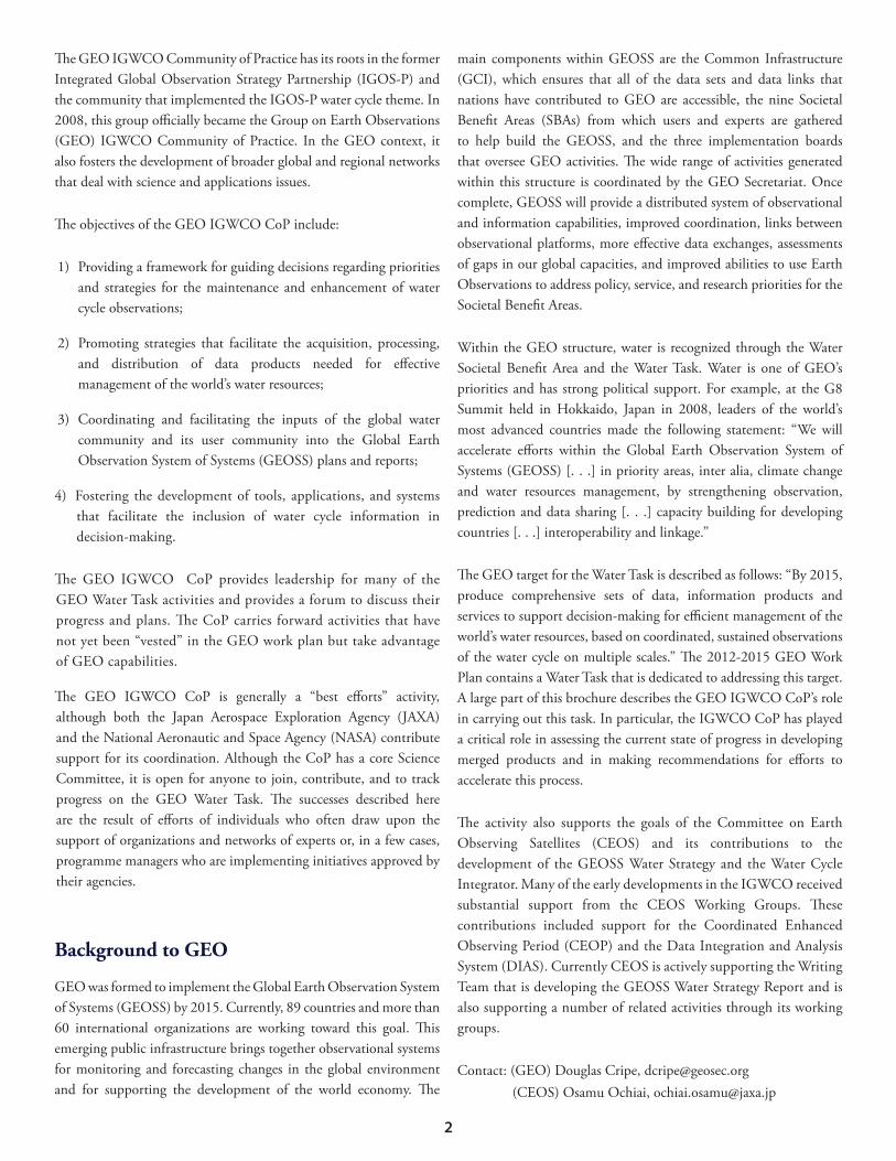
Aided by funding from the Asian Pacific Network, the Asian Water Cycle Initiative (AWCI) has launched a successful capacity-building activity that provides training to technical and scientific staff across Southeast Asia. Its goal is to develop sustainable mechanisms for use of advanced Earth Observations systems, associated data, and tools for water cycle research and water resources management under the GEOSS framework. Priority issues being addressed through these efforts include downscaling regional and global information to the basin scale; improving forecast accuracy for operational water management applications through a combination of numerical forecasting and the fusion of local observations; and identifying reliable and efficient tools to convert the available observations and data into useful information for flood management.
Given the disparity in existing capabilities among different countries as well as their varied needs, AWCI devotes considerable effort to assessing priority needs. Based on these assessments, floods, droughts, and water quality are the three primary focus areas for AWCI. AWCI has surveyed the capacity development needs of the member countries. The participating universities, space agencies, and research institutes have already registered modules for training in GEO. AWCI can design unique training courses by aggregating several modules to provide tailor-made training (see Figure 17).
In addition, a generic template is used for each problem area to plan capacity development and training activities. The training is provided in three modes:
Mode 1: Country-based presentations (roving seminars in a local catchment with a number of training modules from within a country).
Mode 2: Training module-based presentations (modules in intensive workshops designed by professional trainers held at training institutes).
Mode 3: Using country data for analysis and training (module-based presentations and hands-on courses that involve some problem-solving and specific applications, often including people from a number of countries).
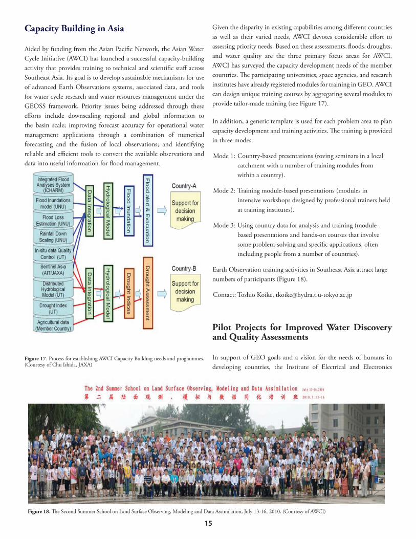
Earth Observation training activities in Southeast Asia attract large numbers of participants (Figure 18).
Pilot Projects for Improved Water Discovery and Quality Assessments
In support of GEO goals and a vision for the needs of humans in developing countries, the Institute of Electrical and Electronics
16
Engineers (IEEE), in collaboration with the IGWCO CoP, has launched a Water for the World programme. In addition to providing direct assistance in developing countries, it also helps shape the advance of Earth Observations in positive and demonstrable ways. The IEEE activity has stimulated the water science community to produce project proposals for the development of applications that will benefit developing countries. IEEE has initiated the first phase of selected pilot projects in cooperation with local, regional, and national groups and other organizations to provide water quantity and quality assistance where they are needed but not available. In particular, IEEE encourages those projects that are realizable in the field within one year and meet the criteria of being sustainable, reusable, repeatable, and scalable. One of the projects in the village of Melva in northern India has produced beneficial results by enabling a community with unreliable water supplies to gain access to quality water on a year-round basis through water harvesting. Earth Observations are used for site selection and management. A second project involving the measurement of water quality in Nicaragua was launched in 2011.
The design of all aspects of the IGWCO CoP activities depends on users’ views of what is important. In response to a user needs assessment exercise carried out by the GEO User Interface Committee during which each GEO SBA surveyed their community’ needs, NASA and GEO IGWCO CoP led an extensive analysis of user needs for water cycle data as documented in the literature. This report has been
integrated with reports from other SBAs and a synthesis has been prepared. The synthesis provides an assessment of the demands for different Earth Observation variables. This assessment concluded that precipitation and soil moisture, two water cycle variables, are the most important EO variables for users across all SBAs.
A subsequent study funded by NASA has been undertaken to examine the need for precipitation information and what steps are needed to satisfy the most urgent demands. This study reviewed end-user requirements in water resources management; climate and global change; weather and extremes; seasonal to inter-annual climate prediction; industrial and economic aspects, including agriculture and energy, among others; environmental and ecosystem aspects; emergency management; transportation (air, land, water); human health, with a focus on water-related disease vectors; and tourism and recreational activities. The study emphasized the fact that user needs are still not being met, in large measure due to the lack of continuity in observational systems, data sharing and communication, and the need for user communication.
A portal-based User Requirements Registry is being added to the GEO Infrastructure as a result of innovations supported by the Environmental Protection Agency (EPA). In recent months, the IGWCO CoP members have been seeking to populate the registry with water-related information. This includes information related to user types, measurements, applications, definitions, research needs, infrastructure needs, and the linkages between the various inputs. The URR can be accessed at http://www.scgcorp.com/urr.
DEPLOYMENT:REGIONAL COMMUNITIES OF PRACTICEThe deployment of integrated systems that involve distinct place-based characteristics and problems often require developments and adaptations that are best implemented at the regional level. This development aspect is addressed by regional Communities of Practice that are implemented on a permanent basis or for a limited time based on support from a sustaining grant. Projects in academia are frequently characterized by a group of experts coming together for a period of time and functioning as a community as they work together to achieve their study objectives and disperse when the funding support ends. Harvesting knowledge, technologies, and data sets and involving experts from these short-term CoPs for long-term global initiatives remains a challenge.
GEOSS Asian Water Cycle Initiative Community of Practice
Building on the AWCI, this regional CoP develops competencies among water management practitioners, researchers, and administrators. (AWCI addresses climate change monitoring in Asia through the integration of in-situ and satellite/remote sensing.) In addition, it builds on Sentinel Asia to develop disaster management support systems in the Asia-Pacific region and expands the number of experts who effectively use satellite products in decision-making.
Approximately 40% of the world’s population lives in Southeast Asia, creating great pressure on those nations to keep their citizens safe and fed. Better systems for warnings and information on floods, droughts, and other natural hazards are urgently needed. The improved use of integrated satellite and in-situ observations together with advanced data assimilation and prediction systems is critical for ensuring that these information services adequately meet the needs of nations for warning systems and planning tools. Furthermore, training and education are needed so that people in every country will have access to information and will use it in order to avoid disasters and to take full advantage of opportunities provided by the freshwater in their natural environment.
To address these common water-related issues, Asian country representatives established the Global Earth Observation System of Systems Asian Water Cycle Initiative (GEOSS/AWCI) in 2005. The GEOSS/AWCI promotes the more effective use of integrated water resources management by making maximum use of Earth Observations and the principles of GEOSS. Twenty member countries work together to use EO to address regional problems. Hydrological data from selected basins in these countries are archived
in a centralized database under a fully open data policy. Satellite data, weather and climate prediction model outputs, and ground-based observed data are integrated to generate information that enables users to make sound water resources management decisions.
European Communities of PracticeEuropean regional water-related CoPs have been tied to specific grants and groups that have worked together for a period of time to achieve a specific objective. From 2009 to 2011, the European GEO Network (EUGENE) project, funded under the Seventh EU Framework Programme (FP7), improved the coordination, visibility, and impact of European GEOSS contributions to the Water SBA. EUGENE reinforced European coordination at the strategic level and triggered cooperation amongst European actors and with international initiatives in three SBAs, including water. EUGENE highlighted the importance of Global Monitoring for Environment and Security (GMES), which is now moving to an operational European Earth Observation programme and becoming an even more central component of GEOSS. Although EUGENE has recently concluded, other targeted research actions under FP7 still contribute to the development of water-related components of GMES (e.g., MyWater, FreshMon, SIRIUS, or GLOWASIS. See http://cordis.europa.eu/fp7/projects_en.html).
EUGENE’s successor, the EU FP7 project GEOSS Interoperability for Weather, Ocean, and Water (GEOWOW), will propose and validate an architectural model federating Earth Observations and other Earth Science data holdings at global, regional and local scales; allow easy and harmonized access to heterogeneous data; contribute to the GCI’s interoperability, standardization and operability; develop services for data dissemination, access, and use for the selected SBAs; establish and promote data-sharing and usage procedures consistent with the GEOSS Data Sharing Implementation Guidelines; and contribute to the development of the GEOSS Data CORE (Collection of Open Resources for Everyone). Under the leadership of the University of Bonn for the water sector, the project will deploy an e-infrastructure giving access to in-situ and satellite data for hydrological applications and run-off process studies (Water SBA). The Global Runoff Data Centre (GRDC) will play a key role in providing data for this study. Specific goals for the water-related work include:
• Improving the interoperable exchange of hydrological data on a global scale
• Testing the GCI architecture against the specific needs of
18
hydrology and implementing the appropriate enhancements• Ensuring for the first time the availability of a common global
exchange infrastructure for hydrological data • Making new data sets accessible in an interoperable way
Canada GEO-U.S. GEO Community of Practice Activities
As a result of workshops and meetings, U.S. GEO and Canada GEO have combined efforts to explore water-related topics in three testbeds along the Canada-U.S. border. The Great Lakes testbed coordination group focuses on the registration of data between the U.S. and Canada. It is coordinated by a diverse group of scientists from the U.S. and Canada involved with water data related to the lakes. As a first step, this group has consolidated ice cover, water level, groundwater, and beach closure data from around the Great Lakes in an internet-accessible, interoperable, standardized format. The metadata catalogues can be accessed on the Great Lakes Observation System (GLOS) web page at http://glos.us/metadata/srv/en/main.home. Future data sets proposed for integration are streamflow data in the Great Lakes basin, climate and hydroclimate data in the basin, Lake Ontario nutrient data, and other water quality parameters.
The Prairies testbed focuses on soil moisture. During the spring of 2010, AAFC collected 24 RADARSAT-2 fully polarimetric images over the Brunkild watershed site in Manitoba. These data are being used to test radar models to estimate surface soil moisture. Products related to crop type and crop condition monitoring using multi-frequency radar data also have been collected and will be used to assess the application of these data for crop type identification. It is anticipated that these activities will be consolidated into a regional CoP that will combine water and agriculture interests.
NASA Technology-Centric Regional Communities of Practice
NASA strongly supports a free and open exchange of its Earth science and satellite data to assist managers in addressing water management issues such as floods, droughts, water for food, and transboundary issues. This NASA free and open data policy is especially valuable for developing countries that typically have limited in-situ and observational data for making informed decisions regarding water
resource planning and management. Within this effort, the NASA Applied Sciences Program has a large portfolio of projects delivering results and enabling partnerships with private and public organizations to address water issues for developing countries, such as enhancing the USAID Famine Early Warning System with remote sensing and modeling products; providing SERVIR (Spanish for to serve) geospatial centres with USAID for developing nations to use remote sensing and Earth science information; in partnership with the World Bank and USAID, installing Water Information System Platforms (WISPs) with remote sensing, geospatial products, and capacity-building for countries in the Middle East and North Africa; developing NASA-based applications for water availability in the Nile Basin; making connections between climate change and water availability in the Himalayas; creating and maintaining Global Flood, Rains, and Landslides Early Warning Systems using satellite data; and monitoring regional to global aquifers with GRACE satellite data. These centres and innovations develop their own user communities, which in turn function as communities of practice promoting dialogue between the providers and users of the services. It is anticipated that these informal CoPs, which are currently unstructured, will make significant contributions to the IGWCO CoP.
The Global Terrestrial Network-Hydrology (GTN-H) (see http://gtn-h.unh.edu) provides a strong basis for WMO-IGWCO interactions, as managers from the data centres and networks provide the data services upon which IGWCO relies. Most GTN-H networks actively support the goals of the IGWCO CoP. The GCOS programme, the Hydrology Branch of the Climate and Hydrology Programme of WMO, and the GTN-H Secretariat operating under WMO guidance at IHP/HWRP Secretariat at the German Federal Institute of Hydrology (BfG) facilitate the coordination of these activities.
WMO (see www.wmo.int), the specialized United Nations agency for weather, climate, and hydrology, organizes projects and sets standards and best practices for many water cycle variables. It also coordinates interactions with the National Meteorological and Hydrological Services (NMHSs) of its 189 members. In addition to the initiatives described earlier, WMO contributes to IGWCO through the WMO Technical Commission for Hydrology (CHy), which has stated that it would use the IGWCO CoP as the principal platform for its contributions to GEO, WMO Integrated Global Observing Systems (WIGOS), the WIS, and the Global Framework for Climate Services (GFCS).
19
GEWEX is a core project of the World Climate Research Programme. It deals with observations, modelling, field campaigns, and applied research in water cycle sciences (see www.gewex.org). GEWEX has been a leading organization in the launch and development of IGWCO and the IGWCO CoP since 2000. It is the main source of expertise and research findings for IGWCO CoP efforts related to the water cycle and its components.
JAXA (see www.jaxa.jp) continues to strongly support the development of observational and data-exchange systems. In addition to providing critical support for precipitation and land surface mapping, JAXA plays an important role by coordinating water cycle activities in CEOS. It supports GEO water cycle activities by funding research and investigations for GEO Water SBA activities and provides direct support for the coordination of IGWCO CoP activities.
NASA (see www.nasa.gov) has provided long-term support to water cycle activities in the U.S. and internationally. Many NASA systems and research activities support the development of data products, models, and information systems used by IGWCO CoP members. Both the NASA Energy and Water Study (NEWS) and the NASA Applied Sciences Program-Water Resources provide direct support to IGWCO activities. NASA has been very supportive of IGWCO work in the Americas and Africa.
The National Oceanic and Atmospheric Administration (NOAA; see www.noaa.gov) has a mandate to improve forecast capabilities and information services for weather, water, and climate, and is responsible for the national stewardship of marine resources. NOAA has supported IGWCO development activities and, more recently, its capacity-building activities in Latin America.
ESA (see www.esa.int) is a leader in developing new observational systems that support water cycle measurements, including topics such as soil moisture. They have also provided significant in-kind support for IGWCO activities and initiatives.
The United Nations Educational Scientific Cultural Organization’s (UNESCO) International Hydrology Programme (IHP) facilitates GEO IGWCO CoP linkages with many user groups in different parts of the world. Regional UNESCO programs have supported IGWCO CoP capacity-building efforts and strengthened the links between Earth Observations and the implementation of Integrated Water Resources Management.
Many other agencies and organizations that provide ongoing support for IGWCO have been mentioned throughout this text. The above-mentioned agencies and organizations have been given special mention because IGWCO CoP would not exist in its present form without their involvement and direct and in-kind support.
Invitation
The GEO IGWCO CoP continues to look for more end-user involvement. As its name implies, it is open to everyone who is connected with the production and use of water data and data products. It is a “best efforts” activity that relies on the good will, competence, and enthusiasm of its members to achieve its goals. If you would like to become involved as a regional community of practice, an organization, or an interested individual, please contact Rick Lawford at [email protected] to discuss the options.
20
To learn more about the IGWCO Community of Practice and the
GEO Water SBA
visit the GEO website at
http://www.earthobservations.org/wa_igwco.shtml
or the informal IGWCO website at
http://www.watercycleforum.com
The IGWCO CoP extends a special thanks to the European Space