Page 1
THE INTEGRATION OF CLOSE RANGE PHOTOGRAMMETRY AND
DATABASE MANAGEMENT FOR TRAFFIC ACCIDENT MAPPING
NURKHALIESA BALQIS BINTI HAMZAH
A thesis submitted in fulfilment of the
requirements for the award of the degree of
Master of Science (Geomatic Engineering)
Faculty of Geoinformation and Real Estate
Universiti Teknologi Malaysia
MARCH 2014
Page 2
iii
To my dearest husband, Saiful Adilin Ab Aziz
my lovely mama, Jamaliah Desa
my late dad, Hamzah Md. Jidin
my siblings, Faris Syahin,
Muhammad Qayyum and
Nur Batrisyia
Page 3
iv
ACKNOWLEDGEMENT
First of all, I thank Almighty, my husband, my parents, brothers, sisters,
family in laws and friends for their constant encouragement without which this thesis
would not be possible.
I take this opportunity to express my profound gratitude and deep regards to
my guide Prof. Dr. Halim Setan and Dr. Zulkepli Majid for their exemplary
guidance, monitoring and constant encouragement throughout the course of this
thesis. The blessing, help and guidance given by them time to time shall carry out me
a long way in the journey of life on which I am about to embark.
I also take this opportunity to express a deep sense of gratitude to PLSRG
members, Sahidatul Fariza, Saidatul Shamila, Rizka Akmalia, Suzanna, Nurul
Shahida, Suraya, Faizah, Sabrina, Erna, and Ajibah for the valuable information
provided by them in their respective fields. I am grateful for their cooperation during
the period of my thesis.
Page 4
i
THE INTEGRATION OF CLOSE RANGE PHOTOGRAMMETRY AND
DATABASE MANAGEMENT FOR TRAFFIC ACCIDENT MAPPING
NURKHALIESA BALQIS BINTI HAMZAH
UNIVERSITI TEKNOLOGI MALAYSIA
Page 5
v
ABSTRACT
Various approaches in acquiring data of road accident are being implemented
worldwide. For police and forensic in Malaysia, they face challenges in obtaining accurate
measurements because they are still implementing the conventional method which is
impractical to map the road accident scene, consequently explain the lack of a
comprehensive accident recording and analysis system. This research presents the
implementation of close range photogrammetry of accident scene for data collection by
using three types of sensors to study the effectiveness of each sensor which are SONY
DSCHX5V for compact camera, NIKON D300S for Single Lens Reflex (SLR) camera and
MI DVJ350 for video recorder. Each accident simulation conducted at Universiti Teknologi
Malaysia (UTM) was recorded and imported into two different processing softwares which
are Photomodeler and iWitness that is employed together with CrashZone, to perform non-
contact measurement on physical evidences and subsequently generate 3D model of the
crash scene. The outcomes of this research are the measurement of evidences and 3D model
of road accident from three types of sensors. Data is stored, organized and retrieved in
accident data management system by using Microsoft Visual Studio together with SQL
Server Management Studio. The result shows that among these three sensors, NIKON
D300S is the best sensor that fit the requirement of law enforcement in acquiring accident
data because it has achieved the highest accuracy for physical evidences measurement. From
iWitness software the RMS obtained was 0.0344m while Photomodeler was 0.0348m. In
conclusion, this research gives benefits and contribution to the Malaysia’s traffic
management system due to the application of close range photogrammetry (CRP). The final
result can be as evidence in court litigation because in most jurisdictions, accidents involving
fatalities must be surveyed and mapped.
Page 6
vi
ABSTRAK
Pelbagai pendekatan di dalam pengumpulan data kemalangan jalan raya sedang
diimplimentasikan di seluruh dunia. Bagi pihak polis dan forensik di Malaysia, mereka
menghadapi cabaran dalam mendapatkan pengukuran yang tepat kerana mereka masih
mengimplimentasi kaedah konvensional yang mana tidak praktikal untuk memetakan
kemalangan jalan raya, seterusnya menunjukkan kelemahan sistem merekod dan analisis
yang komprehensif. Kajian ini mempersembahkan pengimplimentasian fotogrametri jarak
dekat terhadap situasi kemalangan untuk pengumpulan data dengan menggunakan tiga jenis
sensor untuk mengkaji keberkesanan setiap sensor iaitu; SONY DSCHX5V mewakili
kamera kompak, NIKON D300S mewakili kamera lensa reflex tunggal dan MI DVJ350
mewakili perakam video. Setiap simulasi kemalangan dijalankan di Universiti Teknologi
Malaysia (UTM) telah direkod dan diimport ke dalam dua perisian pemprosesan berbeza
iaitu Photomodeler dan iWitness yang digunakan bersama dengan CrashZone, untuk
melakukan pengukuran tanpa sentuh terhadap bukti-bukti fizikal dan seterusnya
menghasilkan model 3D suasana kemalangan tersebut. Hasil kajian ini adalah pengukuran
bukti-bukti dan model 3D kemalangan jalan raya daripada tiga jenis sensor. Data telah
disimpan, diselenggara dan dicapai di dalam sistem pengurusan data kemalangan dengan
menggunakan Microsoft Visual Studio bersama dengan SQL Server Management Studio.
Keputusan menunjukkan di antara ketiga-tiga sensor ini, NIKON D300S adalah sensor
terbaik yang sesuai dengan keperluan pihak penguasa dalam mendapatkan data-data
kemalangan kerana ia telah mencapai ketepatan paling tinggi bagi pengukuran bukti-bukti
fizikal. Dari perisian iWitness, RMS yang diperolehi adalah 0.0344m manakala
Photomodeler adalah 0.0348m. Secara kesimpulannya, kajian ini memberi kelebihan dan
sumbangan kepada sistem pengurusan trafik Malaysia disebabkan aplikasi fotogrametri jarak
dekat (CRP). Keputusan akhir boleh dijadikan sebagai bukti di perbicaraan mahkamah
kerana dalam kebanyakan bidang kuasa, kemalangan yang melibatkan kematian mesti
diukur dan dipetakan.
Page 7
vii
TABLE OF CONTENTS
CHAPTER TITLE PAGE
DECLARATION ii
DEDICATION iii
ACKNOWLEDGEMENT iv
ABSTRACT v
ABSTRAK vi
TABLE OF CONTENTS vii
LIST OF TABLES x
LIST OF FIGURES xi
LIST OF ABBREVIATIONS xv
LIST OF APPENDICES xvi
1 INTRODUCTION 1
1.1 Background of Study 1
1.2 Problem Statement 3
1.3 Objectives of Study 4
1.4 Scope of Study 5
1.5 Significance of Study 7
1.6 Thesis Chapters Layout 8
2 LITERATURE REVIEW 10
2.1 Information on Traffic Accidents 10
2.2 Methods Used in Traffic Accident Data Collection 13
2.2.1 Conventional Method 14
2.2.2 Close-Range Photogrammetry 16
Page 8
viii
2.2.3 Other Methods 21
2.3 Traffic Accident Management System 24
2.4 Critical Needs of Road Accident Database 29
2.5 General Requirement to Develop Road Accident 32
System
2.6 Type of Database Management System (DBMS) 36
2.6.1 Relational DBMS (RDBMS) 37
2.6.2 Hierarchical 38
2.6.3 Object-oriented (O-O) 39
2.7 Chapter Summary 41
3 RESEARCH METHODOLOGY 44
3.1 Flowchart of Research Methodology 44
3.2 Traffic Accident Mapping 46
3.2.1 Data Collection 46
3.2.2 Data Processing 48
3.2.2.1 Image Processing in iWitness and 48
CrashZone
3.2.2.2 Image Processing in Photomodeler 56
3.3 Traffic Accident Data Management System 61
3.3.1 Overall Workflow 62
3.3.2 Database Design 63
3.3.3 Database System Development 67
3.3.4 System Evaluation 68
3.4 Chapter Summary 69
4 RESULT AND ANALYSIS 70
4.1 Introduction 70
4.2 Camera Calibration 70
4.2.1 iWitness Camera Calibration 71
4.2.2 Photomodeler Camera Calibration 72
Page 9
ix
4.3 Example of Road Accident Simulation 74
4.4 Accuracy of Referencing 76
4.5 Measurement of Physical Evidences 79
4.6 3D Model of Accident Reconstruction 83
4.6.1 3D Model of Accident Reconstruction 84
in iWitness and CrashZone
4.6.2 3D Model of Accident Reconstruction 86
in Photomodeler
4.7 Design and Development of Road Accident 89
Database
4.7.1 Database Query 89
4.7.2 User Interface 90
4.7.2.1 Starting Window 91
4.7.2.2 Complainant Report 91
4.7.2.3 Investigation Result 93
4.7.2.4 Staff Registration 94
4.7.3 Road Accident Report Generator 95
4.8 Chapter Summary 99
5 CONCLUSION AND RECOMMENDATION 104
5.1 Conclusion 104
5.2 Recommendation 106
REFERENCES 108
APPENDICES
Appendix A to W20 122
Page 10
x
LIST OF TABLES
TABLE NO. TITLE PAGE
1.1 Thesis Chapters Layout 9
2.1 Existing Traffic Accident Mapping and Data Management 41
3.1 Sample of Physical Evidences 53
4.1 Camera Calibration Result in iWitness for Three Cameras 71
4.2 Camera Calibration Result in Photomodeler for Three Cameras 73
4.3 Root Mean Square for iWitness and Photomodeler Project (in Pixel) 78
4.4 Dimensions of Physical Evidences Using Measurement Tape and 81
iWitness Based on 3 Cameras (Simulation 1)
4.5 Dimensions of Physical Evidences Using Measurement Tape and 82
Photomodeler Based on 3 Cameras (Simulation 1)
4.6 Comparison between This Research and Current Implementation 99
by PDRM and UTM Security Unit
4.7 Comparison between Photomodeler and iWitness Software 101
4.8 Comparison between Three Types of Cameras 102
Page 11
xi
LIST OF FIGURES
FIGURE NO. TITLE PAGE
1.1 Research Area 5
1.2 i) Compact Camera, SONY DSC HX5V 6
ii) SLR Camera, NIKON D300S
iii) Video Recorder, MI DVJ350
2.1 Results of Traffic Accidents 11
2.2 Total Road Accidents and Motor Vehicles Involved 2001 to 2010 12
2.3 Types of Manual Measurement 14
2.4 Sketch of a Traffic Accident in POL27 Form 16
2.5 Police Investigators Using Camera to Collect Data 17
2.6 Sketches from James Dean Accident Scene 19
2.7 Crashteam (2008) converted an image that shows skid marks to 20
scale top down view of the scene. The right image was central
to the scene reconstruction and development of an accurate
accident scene for speed calculation and 3D animation.
2.8 Concept of Close Range Photogrammetry 20
2.9 Data Collection using Total Station and Laser Scanning 22
2.10 A reconstructionist and forensic mapping trainer, 23
uses a Sokkia robotic total station to map the scene of
a two-vehicle crash.
Page 12
xii
2.11 Data visualization on seat belt usage in Vectormap. 25
2.12 Components of Abu Dhabi’s Traffic Information Management 27
2.13 Road Traffic Information Centre 27
2.14 Intelligent Road Accident System (IRAS) 28
2.15 Statistic of Road Deaths per 100000 Populations 30
2.16 Road Safety Strategy 31
2.17 Vehicle and Operator Services Agency (VOSA) Accident Database 33
2.18 PDRM Requirement for Measuring Crash Data 36
2.19 Example of Relational Data Model 38
2.20 Formal Relational Term versus Informal Equivalents Term 38
2.21 Hierarchical Database Model 39
2.22 Object Oriented Database Model 40
3.1 Flowchart of Research Methodology 45
3.2 Process of Data Collection 47
3.3 Process of Data Processing in iWitness and CrashZone 49
3.4 The Arrangement of Colour Coded Target for iWitness Camera 49
3.5 Referencing a Corresponding Feature Point in an Initial Image Pair 50
3.6 Process of Editing 52
3.7 Placing a Car Symbol from Symbol Manager Toolbox onto the 55
Drawing Window
3.8 Marking Process in Photomodeler 58
3.9 Setting Up Project Unit and Scale 58
3.10 Wireframe of Digitized Points and Lines 60
3.11 Path Surfaces is Applied into the Project 60
3.12 Fast Textures is Applied into the Project 60
3.13 Quality Textures is Applied into the Project 61
3.14 Overall Workflow for Road Accident Data Management 63
Page 13
xiii
3.15 (a): ER Diagram (Conceptual Model) 64
(b): ER Diagram (Logical Model) 65
(c): ER Diagram (Physical Model) 66
4.1 Camera Calibration Result (iWitness) 71
4.2 Camera Calibration Result (Photomodeler) 73
4.3 Location of a Simulation of Road Accident 75
4.4 A Scene of Road Accident 76
4.5 3D Point Table for iWitness 77
4.6 3D Point Table for Photomodeler 78
4.7 Sample of Measuring a Feature of Interest in iWitness 80
4.8 Sample of Measuring a Feature of Interest in Photomodeler 80
4.9 2D Diagram of Accident Scene 84
4.10 (a) Images from Camera 85
(b) 3D Reconstructed Model 85
4.11 Wireframe of Digitized Points 87
4.12 Model has been Added Surfaces 87
4.13 Model in Fast Textures 87
4.14 Model in Quality Textures 88
4.15 Model in Quality Textures without Points and Lines 88
4.16 User Form to Make Query 90
4.17 Starting Window 91
4.18 Complainant Form 92
4.19 Investigation Result of an Accident Case 93
4.20 Details of Staff Registration 94
4.21: Total Three Data in Database 95
4.22: Search by Specific Accident Report Number 96
4.23: Search by Specific Accident Location 96
Page 14
xiv
4.24: Search by All for Complainant Information Report 97
4.25: Search by All for Vehicle Information Report 98
Page 15
xv
LIST OF ABBREVIATIONS
CAD - Computer Aided Design
CRP - Close Range Photogrammetry
DXF - Drawing Exchange Format
RMP - Royal Malaysia Police
RMS - Root Mean Square
SLR - Single Lens Reflex
TLS - Terrestrial Laser Scanning
2D - 2 Dimension
3D - 3 Dimension
DBMS Database Management System
Page 16
xvi
LIST OF APPENDICES
APPENDICES TITLE PAGE
A Image of Camera Calibration in iWitness for SONY DSCHX5V 122
B Image of Camera Calibration in iWitness for NIKON D300S 123
C Image of Camera Calibration in iWitness for MI DVJ350 124
D AutoCal Button to Run Camera Calibration Automatically 125
E Process of Assigning a Scale 125
F XYZ Coordinate Axes in iWitness 126
G Button to View Crash Area in 3D Model 126
H Camera Calibration in Photomodeler 127
I Image activated as the Source in Referencing Mode 127
J Icon of Camera Indicating Position of the Camera Has Been 128
Oriented
K Positions of Camera 128
L Setting Up for Rotation Axes in Photomodeler Project 129
M Measurement of Point of Interest 129
N URA: Interview Session with PDRM-Inspector Haidir 130
O URA: Interview Session with UTM Security Unit-Mr. Norazam 133
P URA: Interview Session with MIROS-Mr. Hizal Hanis 135
Q Road Accident Sketch-by Computer 138
R Road Accident Sketch-by Hand 139
Page 17
xvii
S Road Accident Report by PDRM 140
T Road Accident Report in hardcopy form by UTM Security Unit 141
U Road Accident Report in HRFin by UTM Security Unit (1) 142
V Road Accident Report in HRFin by UTM Security Unit (2) 143
W1 Difference Value of Camera Parameters in iWitness 144
W2 Images for Processing (Simulation 1) 145
W3 Images for Processing (Simulation 2) 146
W4 Images for Processing (Simulation 3) 147
W5 Images for Processing (Simulation 4) 148
W6 Images for Processing (Simulation 5) 149
W7 Dimensions of Physical Evidences Using Measurement Tape and 150
iWitness Based on 3 Cameras (Simulation 2)
W8 Dimensions of Physical Evidences Using Measurement Tape and 151
Photomodeler Based on 3 Cameras (Simulation 2)
W9 Dimensions of Physical Evidences Using Measurement Tape and 152
iWitness Based on 3 Cameras (Simulation 3)
W10 Dimensions of Physical Evidences Using Measurement Tape and 153
Photomodeler Based on 3 Cameras (Simulation 3)
W11 Dimensions of Physical Evidences Using Measurement Tape and 154
iWitness Based on 3 Cameras (Simulation 4)
W12 Dimensions of Physical Evidences Using Measurement Tape and 155
Photomodeler Based on 3 Cameras (Simulation 4)
W13 Dimensions of Physical Evidences Using Measurement Tape and 156
iWitness Based on 3 Cameras (Simulation 5)
W14 Dimensions of Physical Evidences Using Measurement Tape and 157
Photomodeler Based on 3 Cameras (Simulation 5)
Page 18
xviii
W15 3D Constructed Model of Accident Scene for Simulation 2 158
(iWitness)
W16 3D Constructed Model of Accident Scene for Simulation 3 159
(iWitness)
W17 3D Constructed Model of Accident Scene for Simulation 4 160
(iWitness)
W18 3D Constructed Model of Accident Scene for Simulation 5 161
(iWitness)
W19 3D Constructed Model of Accident Scene for Simulation 2 162
(Photomodeler)
W20 3D Constructed Model of Accident Scene for Simulation 4 163
(Photomodeler)
Page 19
1
CHAPTER 1
INTRODUCTION
1.1 Background of Study
As time goes by, traffic accident has been a concern of the world community
since the number of accidents occurs has increased drastically. According to Sahar
and Jehan (2010), this phenomenon is increasingly being recognized as a growing
public issue. There are many factors that cause road collision including the behaviour
of driver, weather conditions, environment of the street, conditions of vehicles and so
forth. Malaysia as a developing country is experiencing growing numbers of vehicles
every year which is also contributing to the numbers of accidents (Road Safety
Department Malaysia, 2010).
Various methods have been introduced to collect the measurement of road
accident data ranged from conventional method to the sophisticated technology. The
data collection techniques includes by using a tape measure, close range
photogrammetry (CRP), laser scanner, and etc (Randles et al, 2010). Based on Haidir
(2012), Malaysian police still make use of tape measure to obtain accident data
measurement. Another method that can be implemented for this initiative is by using
digital cameras.
Page 20
2
These sensors comprises of cameras that can be utilized for capturing images
and videos. Recorded images are the source of accident data collection to do
measurement on evidences, reconstruct and map the crash scene afterwards. Crash
data can be obtained by using close range photogrammetry (CRP) method. Coyle
(2008) stated that CRP can be implemented in motor vehicle accident reconstruction
while Richard and Stephen (2000) declared that videogrammetry can be used by
forensic engineers to assist them in the same field.
There are numerous effects of a road accident to the individual involved, their
family, and towards the country (Qirjako et al., 2008). Hence, many efforts have
been made by different organizations in improving safety each year. The utilization
of computers makes this effort more comprehensive and productive. One of the
approaches is by using Geographic Information System (GIS) technology which has
been a vital tool for visualization of accident data and analysis of hotspots on the
road. Mino and Asada (2003) explained that they have demonstrated the spatial
information technology such as GIS which can assist their case study.
The key of this study is to investigate five simulation cases of traffic
accidents by using 3 types of camera which are SONY DSCHX5V for compact
camera, NIKON D300S for Single Lens Reflex (SLR) camera and MI DVJ350 for
video recorder. The accident scene is recorded and imported into two different
processing softwares which are iWitness that is employed with CrashZone and
Photomodeler to perform non-contact measurement on physical evidences. The
generation of 3D model of crash scene is made afterwards. The outcomes from these
three types of sensors are the measurement of evidences and 3D model of road
accident that are analyzed in data analysis section.
Accident data that has been processed are the input for the database to be
further analysed. These data are served as visualization purpose in the traffic accident
database system. The data management system is developed using Visual Studio to
Page 21
3
determine accident location, to identify the details of particular accidents and also to
determine how accident countermeasures can be implemented.
1.2 Problem Statement
One of the major concerns for police investigators and forensic scientists in
Malaysia is the challenges in documenting traffic accident scenes to obtain accurate
measurements. The approach for collecting the measurement of evidences is
conventional method which is using a tape measure (Yew, 2009). It is almost
impractical to map the scene due to many issues such as traffic jam, the environment
of the road, unstable flooring, and line of sight issues consequently this is often
inaccurate for 3D data.
In spite of this matter, other techniques that can be implemented for most
cases are close range photogrammetry. Currently, law enforcement in Malaysia
depends on images captured on site of the accident scene which is only for
visualization purpose (Haidir, 2012). The utilization of camera for them is just for
pointed out the evidence which is difficult when it comes to retrieve the data.
Nowadays, different types of camera are available in the market with
different technology and specification. Thus, the need to find the suitability of
camera must be discovered to be the best sensor that can fit the requirement of law
enforcement in acquiring accident data. This camera is expected to give the best
image resolution and achieve the highest accuracy for physical evidence
measurement.
Page 22
4
The representation of different type of cameras; SONY DSCHX5V for
compact camera, NIKON D300S for SLR camera and MI DVJ350 for video
recorder, producing a variety of data accuracies in terms of image processing. Hence,
analysis is done to evaluate the effectiveness of using three types of camera based on
different data accuracy.
In the aspect of data processing, the usage of two different softwares which
are iWitness and PhotoModeler yield different quality of evidences measurement and
the reconstruction of accident scene. To check the reliability of accident simulation,
5 different cases were carried out by using the same three types of camera together
with the two kinds of CRP data processing softwares. In brief, various types of
camera and processing softwares are used in this research to produce different type
of data. The result is different according to accident cases, sensor’s accuracy,
measurement of evidences, and crash scene mapping.
In addition, accident recording and analysis system must be developed to
support crash data that are obtained by using proposed sensors. Therefore, an
appropriate database is necessary to help the police investigators and forensic
scientists to assist and manage the road collision data.
1.3 Objectives of Study
The objectives are specified as follows:
i) To reconstruct 3D model of simulation of five accident scenes by
using PhotoModeler and iWitness software according to different
types of camera.
ii) To develop traffic accident database system.
Page 23
5
1.4 Scope of Study
Four scopes of research are listed as below:
i) Area of study is conducted in Universiti Teknologi Malaysia (UTM)
as shown in Figure 1.1. It is located at Johor Bahru, the southern city
in Iskandar Malaysia with 1177 hectares of land. The simulations of
road accidents are located at 5 different places (yellow pinpoint)
which are identified as ‘hotspots’ in UTM area.
Figure 1.1: Research Area
Scale 1:25000
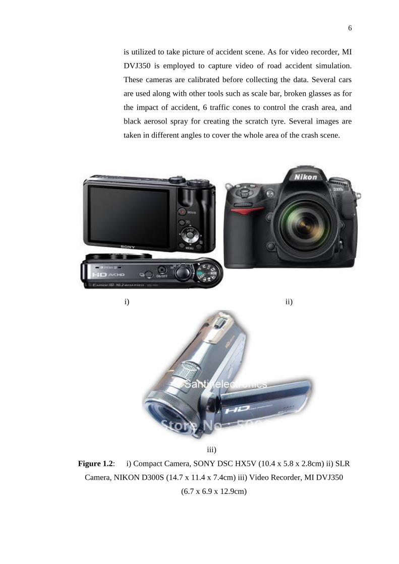
ii) 5 data of road accidents is obtained from 5 accident simulations. Crash
scenes are captured by using 3 types of sensors which are SONY
DSCHX5V (10.2 Megapixels), NIKON D300S (12 Megapixels) and
MI DVJ350 (20.1 Megapixels) as illustrated in Figure 1.2. SONY
DSCHX5V is used to capture images of road accidents to represent
compact camera. NIKON D300S is characterized as SLR camera also
N
Page 24
6
is utilized to take picture of accident scene. As for video recorder, MI
DVJ350 is employed to capture video of road accident simulation.
These cameras are calibrated before collecting the data. Several cars
are used along with other tools such as scale bar, broken glasses as for
the impact of accident, 6 traffic cones to control the crash area, and
black aerosol spray for creating the scratch tyre. Several images are
taken in different angles to cover the whole area of the crash scene.
i) ii)
iii)
Figure 1.2: i) Compact Camera, SONY DSC HX5V (10.4 x 5.8 x 2.8cm) ii) SLR
Camera, NIKON D300S (14.7 x 11.4 x 7.4cm) iii) Video Recorder, MI DVJ350
(6.7 x 6.9 x 12.9cm)
Page 25
7
iii) The data are processed by using 2 softwares:
a) iWitness and CrashZone: iWitness is used to process the data
in terms of measurement. In addition, iWitness also used to
perform the camera calibration. CrashZone support iWitness in
order to display the 3D view of the collision scene.
b) Photomodeler: A photogrammetric-based processing software
that measures and model real world objects and scenes through
the use of images. This software brings the powerful
capabilities of photogrammetry in a simple, user friendly
Windows environment (Eos, 2010).
iv) The database of road accident data is stored in SQL Server
Management Studio while the system is developed in Microsoft
Visual Studio 2010.
1.5 Significance of Study
Various actions and treatments have been taken to reduce the rate of traffic
accident in the whole world. According to U.S Department of Interior (2003), “an
accident investigation is the methodical collection of evidence (facts), and the
analysis and interpretation of the evidence. The fundamental purpose is to identify
the cause, why the accident happened, and to recommend corrective actions to
prevent or minimize the chance of a reoccurrence.” Thus, accident data is significant
for government and road agencies as it is served as evidence in jurisdictions and as
countermeasure for road safety.
CRP is an alternative way to conventional method to obtain measurement of
traffic accident data. This technique is more practical to be implemented because of
Page 26
8
the reducing on scene time, which leads to shorter periods of traffic disruption.
Furthermore, the procedure is easy to adopt for assisting police officers in managing
the road accident case.
This research is expected to give benefits and contribution to the Malaysia’s
traffic management system due to the application of CRP. The final result can be as
evidence in court litigation because in most jurisdictions, accidents involving
fatalities must be surveyed and mapped. In brief, this research contributes to current
practice of data collection with reducing the time and provides higher accuracy of
positional crash data.
Variety of study and advice as well as mass media reports regarding the cause
of the accident give useful messages to other road users. Despite, this tragedy on the
roads continues to be a burden to the society. Thus, this study is essential for traffic
accident management by utilization of database system. Since the rate of road deaths
increases, a database system is extremely significant tool for traffic safety.
This tool has been employed more commonly by many traffic agencies for
accident analysis due to the variety of function such as storing, sharing and managing
a great quantity of data. Thus the need to attempt to avoid road accidents by
whatever means that are effective will become increasingly important.
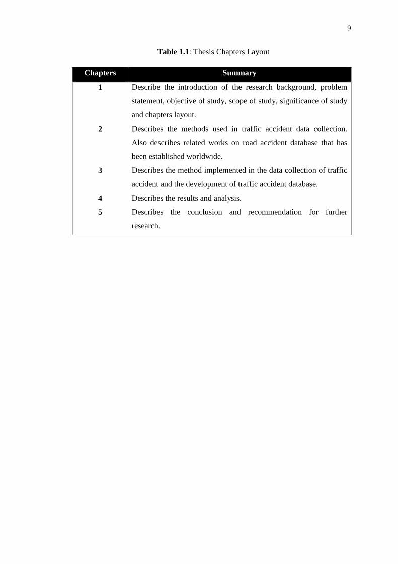
1.6 Thesis Chapters Layout
This thesis consists of five chapters, Table 1.1 described the summary of
each chapter.
Page 27
9
Table 1.1: Thesis Chapters Layout
Chapters Summary
1
2
3
4
5
Describe the introduction of the research background, problem
statement, objective of study, scope of study, significance of study
and chapters layout.
Describes the methods used in traffic accident data collection.
Also describes related works on road accident database that has
been established worldwide.
Describes the method implemented in the data collection of traffic
accident and the development of traffic accident database.
Describes the results and analysis.
Describes the conclusion and recommendation for further
research.
Page 28
108
REFERENCES
Ahmad R.M.and Ehsan, Z. (2008). Intelligent GIS-Based Road Accident Analysis
and Real-Time Monitoring Automated System using WiMAX/GPRS. Faculty
of Engineering, University Putra Malaysia.
Alfredo, C.F. (2011). Mobile GIS in Police Vehicles for Henrico County, Virginia.
Geographic Information Systems Coordinator. County of Henrico, Virginia.
Alley, A.A.(2010). SONY DSCHX5V.
(http://www.articlealley.com/article_1453082_10.html). Retrieved on 15
December 2010.
Ambros, J. (2008). Building the Czech Road Safety Observatory. 21st ICICT
Workshop. Session VI: Road Safety Assessment. Transport Research Centre.
Anna, K. (2010). User Interface Design. PowerPoint Presentation. NextLab Mobile
Innovation for Global Challenges.
Arnold, E.D. (2007). Use of Photogrammetry as a Tool for Accident Investigation
and Reconstruction: A Review of the Literature and State of the Practice.
Research Report. Virginia Transportation Research Council, 530 Edgemont
Road, Charlottesville.
Avnish, S. (2013). Types of DBMS. Retrieved on 19 December 2013. Slideshow.
http://www.slideshare.net/avnishshaw/types-dbms
Page 29
109
A’sim, M.A.I. (2010, June 17). Sikap Ithar Bantu Atasi Kemalangan Jalan Raya.
Berita Harian Online. Research Officer. Pusat Kajian Syariah, Undang-
undang dan Politik Institut Kefahaman Islam Malaysia (IKIM).
Baguley, C. (2001). The Importance of a Road Accident Data System and its
Utilisation. International Symposium on Traffic Safety Strengthening and
Accident Prevention. 28-30 November. Nanjing, China
Berita Harian (2011). 27 Januari 2011. Page 1
Berry, T. B. (2008). Pre-Incident Planning must go to the Head of Class for Nation’s
Schools.(http://www.respondersafetyonline.com/Classes/Articles/ArticleDra
w_P.asp) Retrieved on 15 December 2010.
Burroughs, G.(1986). Relational Database Management Systems, Database Design,
and GIS. Presented by Tim Haithcoat. Slideshow. University of Missouri,
Columbia.
Burtenshaw, G. (2011). Vehicle and Operator Services Agency Database System.
Retrieved on 30 June 2011.
https://www.trlsoftware.co.uk/Content.aspx?ID=27
Campbell, A.T. and Friedrich R.L. (1993). Adapting Three-Dimensional Animation
Software for Photogrammetry Calculations. ALFA Engineering, Inc.
Chant, L.D (2008). Multi-image Convergent Triangulation and Single-image
Planar-Rectification for Law Enforcement Mapping. [Consultation]. DeChant
Consulting Services – DCS Inc.
Cherry, E., Floyd, R., Graves, T., Martin, S., and Ward, D. (2006). Crash Data
Collection and Analysis System. [Report]. Arizona Department of
Transportation.
CIS (2013). Introduction to Database Management.
http://webdesignersworld.info/cis244/?p=432
Page 30
110
CISCO System, Inc. (2007). Mobile Government Transformation with Next-
Generation Cisco Outdoor Wireless Solution. [Brochure]. United States of
America: Solution White Paper.
Cohen, K. (2007). Digital Still Camera Forensics. Small Scale Digital Device
Forensics Journal. Volume 1 (1).
Coyle, F. (2008). Digital Close Range Photogrammetry in Motor Vehicle Accident
Reconstruction. Ph.D Theses. Dublin Institute of Technology.
Crashteam (2008). Accident Reconstruction. (http://crashteams.com/index.htm)
Retrieved on 14 July 2011.
Cusick, J. (2010). Sony DSC-HX5V Embedded GPS and Compass.[PowerPoint
Presenattion]. National Park Service.
DeChant, L. (2006). How a Photogrammetry Expert Can Help You Win Your Case.
[Brochure]. Bellevue: Dechant Consulting Services. DCS Inc.
Demirel, A. and Akgungor, A.P. (2002). The Importance of Report in the Accident
Analyses, Problems in Application and Recommendations for Solution.
International Traffic and Road Safety Congress. Ankara, Turkey.
Duesing, B. (2006). PhotoModeler Takes Accident Documentation Off Road.
Cygnus Interactive. Volume: 33 Nbr. 6.
Eos System Inc. (2010). Photomodeler Software. Canada. Version 6.
ESRI (2004). ArcPad: Mobile GIS. [Brochure]. United States of America: ESRI
White Paper.
Fikri, H. (2012). Storing Organizational Database. Retrieved on 19 December
2013. http://fikriharith.blogspot.com/2012_08_01_archive.html
Page 31
111
Fraser, C.S., Hanley, H.H. and Cronk, S.C. (2005). Close-Range Photogrammetry
for Accident Reconstruction. University of Melbourne, Australia :
Department of Geomatics.
Fraser, C.S., Hanley, H.H. and Cronk, S.C. (2008). Close-Range Photogrammetry in
Traffic Incident Management. University of Melbourne, Australia:
Department of Geomatics.
Galvin, B. (2004). Focus on photography. Evidence Technology Magazine. The
Gulick Corporation. SW Watson, Beaverton. Volume 2, Number 5.
Galvin, B. (2005). Photogrammetry Mapping for Crime Scene Mapping. [Brochure].
Oregon, Portland.
Galvin, B. (2007). Mapping Choices Abound as Traffic and Crashes Mount. Law
Enforcement Technology Magazine.
http://www.lasertech.com/content/pdfs/Law-Enforcement-Technology-
Mapping-Article.pdf Retrieved on 19 December 2013.
Galvin, B. (2010). For Las Vegas Fatal Crash Unit, A Gamble on GPS System to
Speed Scene Mapping Pays Off. Article, ARC Network.
Geospatial Expert (2010). GPS-Photo Pro 2709.
(http://www.geospatialexperts.com/gpsphoto-2709-p-115.html). Retrieved on
14 July 2011.
Ghaly, A. (2010). Abu Dhabi’s Traffic Information and Management System: Traffic
Counting and Operational Analysis (COPAS). Retrieved on 30 June 2011.
Goldman, J. (2010). SONY Cybershot DSC HX5V. (http://reviews.cnet.com/digital-
cameras/sony-cyber-shot-dsc/4505-6501_7-33939643.html#reviewPage1)
Retrieved on 14 July 2011.
Page 32
112
Goldstein, M. (2010). Sony Cyber-shot DSC-HX5 Review.
(http://www.photographyblog.com/reviews/sony_cybershot_dsc_hx5_review
) Retrieved on 14 July 2011.
Google Earth (2011). Google Earth. (http://www.google.com/earth/index.html)
Retrieved on 15 August 2011.
Haidir, S. (2012). Personal Communication. Royal Malaysian Police, Traffic Unit,
Taman Ungku Tun Aminah, Johor Bharu.
Healey R.G. (1991). Database Management System in Geographic Information
System. Volume I. Study Material.
http://agris.faoswalim.org/resources/NEW%20Docs/Books%20and%20paper
s/Geographic%20Information%20Systems,%20First%20Edition,%201991-
Longley%20et%20al/BB1v1_ch18.pdf
Hill, J and Cuerden, R. (2005). Development and Implementation of the UK on The
Spot Accident Data Collection Study – Phase I. [Report]. Department for
Transport, London.
Hirasawa, M. and Asano, M. (2003). Development of Traffic Accident Analysis
System Using GIS. Proceedings of the Eastern Asia Society for
Transportation Studies. Traffic Engineering Division Civil Engineering
Research Institute of Hokkaido, Japan. Volume. 4, pp. 1193–1199.
Hizal, H. and Sharifah Allyana S.M.R. (2009). The Construction of Road Accident
Analysis and Database System in Malaysia. International Traffic Safety Data
and Analysis Group IRTAD Conference. 16-17 September 2009. Seoul,
Korea.
Hoekwater, J. (2008). On Scene Traffic Accident Investigation Level I. [Report].
Georgia Police Academy.
Hossein, M., Ali, A.A. and Ghorbani, M. (2003). Developing Wireless GIS: Using
Java and XML Technologies. Map Asia Conference. GIS Department,
Page 33
113
Faculty of Geodesy and Geomatics Eng. K.N. Toosi University of
Technology Vali_Asr St., Mirdamad Cross, Tehran, Iran.
iWitness Manual (2008). Photometrix Pty Ltd Australia. Version 1.107
Japan Digital Road Map Association (2003). Uses of Digital Road Map.
(http://www.drm.jp/english/drm/database/use.html.) Retrieved on 5 October
2010.
Java4all (2012). Relational Database Model (RDBMS).
.http://www.java4all.in/oracle/oracle-intro.php Retrieved on 19 December
2013
Joeldgreat (2011). Introduction to Accident Investigation Process in a
Manufacturing Industry. Retrieved on 1 July 2011.
http://expertscolumn.com/content/introduction-accident-investigation-
process-manufacturing-industry
Jun, G. and Peter, T. (2004). Guidelines for Handheld Mobile Device Interface
Design. Proceedings of DSI 2004 Annual Meeting. College of Computer
and Information Science, Northeastern University, United States of
America. Page: 3751-3756.
Katims, L.N. (2011). Kansas City Police Use Forensic Mappping to Unvestigate
Accidents. Retrieved on 5 November 2011. http://www.govtech.com/public-
safety/Kansas-City-Police-Use-Forensic-Mapping-to-Investigate-Accidents.html
Khan, M.A., Kathairi, A.S.A., and Garib, A.M. (2009). A GIS Based Traffic
Accident Data Collection, Referencing and Analysis Framework for Abu
Dhabi. CODATU XI : World Congress : Towards More Attractive Urban
Transportation. 22-24 April. Bucarest, Romania, Page 292-302.
Page 34
114
Lee, S.M. (2012). The ER Database Model.. Powerpoint of Study Material.
http:///www.cs.sjsu.edu Retrieved on 21 October 2012.
Leonardo, C.G. (2011). The Requirement of Camera in Accident Data Collection.
Personal Communication. SKYMAX DG, Italy.
Liang, L.Y., Mo’some, D.M. and Hua, L.T. (2005). Traffic Accident Application
Using Geographic Information System. Journal of the Eastern Asia Society
for Transportation Studies. Department of Civil Engineering Faculty of
Engineering University Putra Malaysia. Volume 6.
Lim, S. (2011). Advanced Road Management System using IT Technology.
International Journal of Engineering and Industries Korea Institute of
Construction Technology.
Lin, H. (2011). Combining VGI with Viewshed for Geotagging Suggestion. Master of
Science in Geoinformation Science and eath Observation. Thesis. University
of Twente, Netherlands.
Longstreet, B. (2009). Laser Scanning for Accident Investigation. Sparview. Spar
Point Research LLC. September 2. Volume 7, No. 16.
Luhmann, T.L. (2010). Close Range Photogrammetry For Industrial Application.
Institute for Applied Photogrammetry and Geoinformatics, Jade University
of Applied Sciences Oldenberg, Oldenburg, Germany. ISPRS Journal of
Photogrammetry and Remote Sensing. Volume 65 Page 6.
Lyons, R. A., Ward, H., Brunt, H., Macey, S., Thoreau, R. and Bodger, O. G. (2008).
Using Multiple Datasets to Understand Trends in Serious Road Traffic
Casualties. Accident Analysis and Prevention 2008. Volume 40, Page:1406-
1410.
Page 35
115
Malaysian Institute of Road Safety Research (MIROS) (2009). Road Facts for
Malaysian Trends. (http://www.miros.gov.my/web/guest/road). Retrieved on
5 October 2010.
Manase, D., Heesom, D., Oloke, D., Proverbs, D., Young, C., and Luckhurst, D.
(2011). A GIS Analytical Approach for Exploiting Construction Health and
Safety Information.
Marc, G. (2009). Photographs versus Reality.
(http://www.visualexpert.com/Resources/photoevidence.html). Retrieved on
14 July 2011.
Meisnerr, A., Wang, Z., Putz, W. and Grimmer, J.(2006). MIKoBOS - A Mobile
Information and Communication System for Emergency Response.
Proceedings of the 3rd International ISCRAM Conference (B. Van de Walle
and M. Turoff, eds.), Newark, NJ. May 2006. United States of America.
Mercury (2013). Police Vehicle Involved in Three-Car Crash.
http://www.themercury.com.au/news/tasmania/police-vehicle-involved-in-
three-car-crash/story-fnj4f7k1-1226727126512 Retrieved on 19 December
2013.
Mikulik, J. (2007). Road Accident Investigation Guidelines for Road Engineers.
Transport Research Centre, Czech Republic.
Ministry of Transport Malaysia (2010). Transport Statistics Malaysia 2010. Statistic.
Ministry of Transport Malaysia.
Mino, N. and Asada, M. (2003). Spatial Analysis of Barrier-Free Environment Using
Geographical Information System (GIS). University of Hyogo Japan. Journal
of Japanese Institute of Landscape Architecture. Volume 66, No. 5, Page:
877-882.
Page 36
116
Mino, N. (2007). Combined Use of GPS Camera and GIS for Mapping Accessibility
on Parks and Outdoor Recreation Sites: Application to Hyogo, Japan.
University of Hyogo, Japan.11th International Conference on Mobility and
Transport for Elderly and Disabled Persons. 18-22 June. Montreal, Canada.
Murat, H.Y., Yakar, M. and Yildiz, F. (2008). Digital Photogrammetry in Obtaining
of 3D Model Data of Irregular Small Objects. Department of Geodesy and
Photogrammetry, Konya, Turkey. ISPRS Symposium. 3-11 July. Beijing,
China.
NHTSA (2010). Crash Outcome Data Evaluation System (CODES) and Applications to
Improve Traffic Safety Decision-Making. United States Department of
Transportation.
Noronha, V. and Church, R.L. (2002). Linear Referencing and Alternate Expressions
of Location for Transportation. Santa Barbara, California: [Report]. Vehicle
Intelligence and Transportation Analysis Laboratory, National Center for
Geographic Information and Analysis.
Nurkhaliesa, B.H. (2010). Reconstruction of Traffic Accident Using iWitness and
Crash Zone Software. Bachelor of Geomatic Engineering. Thesis. Universiti
Teknologi Malaysia, Skudai.
Nur Fazzillah, M.N. (2010). Centralized System for Road Accident, Safety and
Hazard Studies (CRASH). Malaysian Institute of Road Safety Research
(MIROS), Malaysia.
Ong, T.K. (2009). Ceremony of Dealers and Sellers in Motorcycle as Ambassador
Road Safety. Speech. Malaysia International Exhibition & Convention
Centre, Mines Resort City, Malaysia.
Ops Sikap: 13 daripada 15 kematian babitkan pengguna motosikal. (2011, January
28). Berita Harian Online.
Page 37
117
O’Shields, L.L., Kress, T.A., Hungerford, J.C., and Alken, C.H. (2004).
Determination and Verification of Equivalent Barrier Speeds (EBS) Using
PhotoModeler as a Measurement Tool. SAE 2004 World Congress &
Exhibition Session: Accident Reconstruction (Part 1 of 4). March 2004:
Detroit, Michigan, USA.
O’Shields, L.L. (2007). Photogrammetry in Traffic Accident Reconstruction. Doctor
of Philosophy Degree. University of Tennessee, Knoxville.
Pagounis, V., Tsakiri, M., Palaskas, S., Biza, B. and Zaloumi, E. (2006). 3D Laser
Scanning for Road Safety and Accident Reconstruction. TS 38 – Engineering
Surveys for Construction Works I. Shaping the Change. Proceedings of the
XXIII International FIG. 8–13 October, Munich, Germany.
PCauthority, (2010). SONY DSCHX5V.
(http://www.pcauthority.com.au/News/166170,get-lost-with-the-sonys-cyber-
shot-dschx5v-thanks-to-built-in-compass-and-gps.aspx). Retrieved on 15
December 2010.
PDRM (2010). Statistic of Road Deaths per 100000 Populations.
(http://www.rmp.gov.my). [Statistic]. Retrieved on 5 October 2010. PDRM
(2010). POL27 Form. [Form]. Polis DiRaja Malaysia.
Pigman, J.G. and Agent, K.R. (2007). State DOT Crash Reconstruction Practices: A
Synthesis of Highway Practice. NCHRP Synthesis 369. Transportation
Research Board.
Qirjako, G., Burazeri, G., Hysa, B., and Roshi, E. (2008). Factors Associated with
Fatal Traffic Accidents in Tirana, Albania: Cross-Sectional Study. Croatian
Medical Journal. Volume 49 (6), Page: 734-740.
Rainer, M. (2008). An Introduction to Relational Database. Slideshow.
http://www.iai.unibonn.de/III/lehre/vorlesungen/IntelligentIS/WS13/Relation
al%20Databases.pdf Retrieved on 19 December 2013.
Page 38
118
Randles, B., Jones, B., Welcher, J., Szabo, T., Elliot, D., and MacAdam, C. (2010).
The Accuracy of Photogrammetry Versus Hands-on Measurement
Techniques Used in Accident Reconstruction. SAE Paper 2010-01-0065, SAE
International. Warrendale, Pennsylvania.
Reddy G.C. (2011). Overview on Databases. Retrieved on 19 December 2013.
Hyderabad, India. http://www.gcreddy.com/2013/03/overview-on-
databases.html
Richard, M.Z. and Stephen, J.F. (2000). Two & Three Dimensional
Photogrammetric Accident Analysis. Journal of the National Academy of
Forensic Engineers. 17 No. 1.
Road Safety Department Malaysia (JKJR) (2010). Road Accident Statistics for the
Year 2000-2009. (http://www.jkjr.gov.my/statistik.html). [Statistic].
Retrieved on 5 October 2010.
Robert, G. (2011). Burden of Proof.
http://www.pobonline.com/articles/95129-burden-of-proof. Retrieved on 19
December 2013.
Sahar, M.S. and Jehan, M.I. (2010). Driving Behavior, Driver Style and Road Traffic
Accidents Among Young Medical Groups. 10th World Safety Conference.
21-24 September. London , United Kingdom, Volume 16 (1).
Saffet, E., Ibrahim, Y., Tamer, B. and Mevlut, G. (2008). Geographical Information
System Aided Traffic Accident Analysis System Case Study: City of
Afyonkarahisar. Afyon Kocatepe University, Faculty of Engineering,
Department of Geodesy and Photogrammetry, Afyonkarahisar, Turkey.
Accident Analysis Prevention. Volume 40 (1), Page: 174-181.
Saidatul, R.A. (2009). Pemetaan Kemalangan Jalan Raya Menggunakan Kaedah
Fotogrammetri Jarak Dekat. Bachelor of Geoinformatic. Thesis. Universiti
Teknologi Malaysia, Skudai.
Page 39
119
SKYMAX (2010). Skymax Vision System. [Brochure]. Milano, Italy: Skymax DG.
Taneja, A. (2000). Other Data Models. Retrieved on 19 December
2013.http://www.ddegjust.ac.in/studymaterial/mca-3/ms-11.pdf
Tao, Z.M. and Pei, Y.L. (2009). Analysis of Deformation Characteristics of
Collision Vehicles Using Close-Range Photogrammetry ICCTP 2009.
Critical Issues in Transportation System Planning, Development, and
Management Proceedings of the Ninth International Conference of Chinese
Transportation Professionals. 5-9 August. Volume 358. China, Pages:177-
184.
Templeton, D.A (2008). Close-Range Photogrammetry as a Routine Crash
Reconstruction Tool within the Florida Highway Patrol. Florida Department
of Transportation, Florida. Collision Publishing LLC. Collision. The
International Compendium for Crash Research. Volume 3 (20). Page:16-20.
Tim, H. (1999). Relational Database Management Systems, Database Design, and
GIS. Slideshow. University of Missouri, Columbia
Traffic Accident Study Guide (2010). Tools of an Accident Investigator. [Report].
International Association of Chief of Police.
U.S Department of Interior (2003). Serious Accident Investigation Chief
Investigator’s Manual. Draft BLM Manual 1112-3. Bureau of Land
Management.
Walton, J.R., Barrett, M.L., and Agent, K.R. (2005). Evaluation of Methods to Limit
the Time Taken to Investigate Crash Sites. [Report]. Kentucky Transportation
Centre.
Wikimedia (2001). Object Oriented Model. U.S. Department of Transportation.
http://commons.wikimedia.org/wiki/File:ObjectOriented_Model.svg
Retrieved on 19 December 2013.
Page 40
120
Wong, Y.J. (2010). Laser Scanning in Accident Mapping. Bachelor of Geomatic
Engineering. Thesis. Universiti Teknologi Malaysia, Skudai.
Xin, G.D. (2008). Geometry features measurement of traffic accident for
reconstruction based on close-range photogrammetry. School of Mechanical
Engineering, Shanghai Jiaotong University, Computer Aided Design
Institute, Department of Mechanical Engineering. Proceedings of Advances
in Engineering Software. Volume 40 (7), Page: 497-505.
Yannis, G., Evgenikos, P., and Chaziris, A. (2009). CADaS - A common road
accident data framework in Europe. 4th IRTAD Conference. 16-17
September, 2009, Seoul, Korea National Technical University of Athens,
Athens, Greece.
Yew, C.H. (2009). Procedure for Road Accident Management. Personal
Communication. Royal Malaysian Police Forensic Laboratory, Cheras, Kuala
Lumpur.