Lab for Advanced Information Technology and Standards (LAITS) School of Computational Science George Mason University (GMU) The Integration of Grid Technology with OGC Web Services (OWS) in NWGISS for NASA EOS Data June 25, 2003 Liping Di, Aijun Chen, Wenli Yang and Peisheng Zhao [email protected]; [email protected]
Transcript
Lab for Advanced Information Technology and Standards (LAITS)
School of Computational ScienceGeorge Mason University (GMU)
The Integration of Grid Technology with OGC Web Services (OWS) in NWGISS for NASA EOS Data
Grid provides an approach for sharing geographically and organizationally dispersed heterogeneous computational resources.
Introduction -1/2
Globus is the key middleware that provides core Grid capabilities. It facilities the creation of usable Grid.NASA Earth Science Enterprise (ESE) is generating a huge volume of remote sensing data in HDF-EOS format for supporting Earth system science and application research. OGC Web Service (OWS) is proposed for addressing the lack of interoperability of geospatial data and processing system based on the Web.
LAITS at GMU developed a OGC-specification compliant software package called the NASA Web GIS Software Suite (NWGISS), which includes WCS, WMS, MPGC etc.
Introduction -2/2
The Committee on Earth Observation Satellites (CEOS) Working Group on Information Systems and Services (CEOS WGISS) started a CEOS-Grid Testbed in September 2002 to evaluate the feasibility and applicability of Grid technology to the Earth Observation (EO) community.
So we are contributing to NASA, OGC and CEOS-Grid by integrating OGC technology with Grid technology through the development of Grid-enabled NWGISS.
Introduction
Outline
Background
Integration of Grid Technology with OWS
System Architecture and Data Flow
Conclusion and Future Work
Globus Project just released Globus 3.0 Beta based on OGSA. But we used Globus 2.2 which includes GRAM, MDS, GSI, GridFTP, MCS, RLS and simple CA etc.
Background -1/2
HDF-EOS is a standard format for NASA EOS data and products. It inherits the portability and multiple data model support of HDF, also adds the three new EOS specific data models – point, swath and grid.LAITS’NWGISS significantly increases the accessibility, interoperability and inter-use of HDF-EOS data. It works with all generic HDF-EOS files.
Since 1999, OGC has successfully implemented three web-based geospatial interoperability programs: WMT I, WMT II and OWS I. And produced a set of web-based data interoperability specifications as WCS, WMS, WFS, and WRS.
Background -2/2
Currently, CEOS-Grid Testbed consists of five Grid demonstration projects:n NOAA Operational Model Archive and Distribution System (NOMADS)n USGS EDC’s Data Deliveryn ESA ESRIN Ozonen NASA GSFC’s Advanced Data Gridn NASA EOSDIS Data Pools
Laits’Virtual Organization and Certificate Authorization center
CA center
LAITS’Host, User and Service certificates:“O=Grid, OU=GlobusTest, OU=simpleCA-laits.gmu.edu, CN=host/laits.gmu.edu”, “O=Grid, OU=GlobusTest, OU=simpleCA-laits.gmu.edu, OU=laits.gmu.edu, CN=Aijun Chen”“O=Grid, OU=GlobusTest, OU=simpleCA-laits.gmu.edu, CN=ldap/laits.gmu.edu”
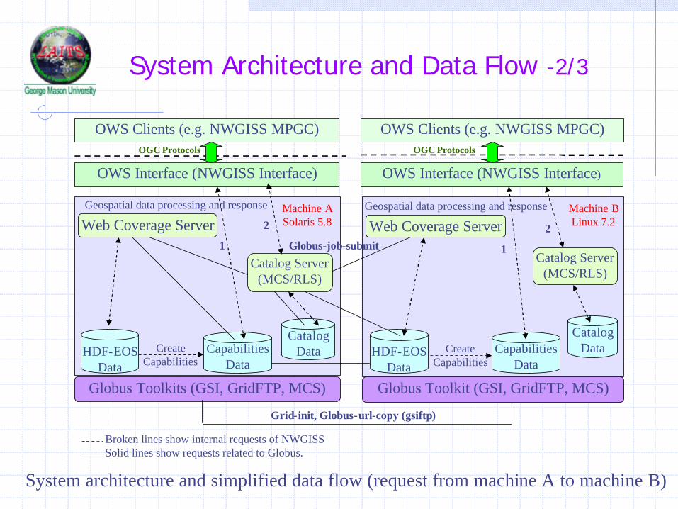
System Architecture and Data Flow -2/3
OWS Clients (e.g. NWGISS MPGC)
OWS Interface (NWGISS Interface)
HDF-EOSData
CapabilitiesData
CatalogData
Web Coverage Server
Catalog Server(MCS/RLS)
Geospatial data processing and response
Globus Toolkits (GSI, GridFTP, MCS)
Machine ASolaris 5.8
HDF-EOSData
CatalogData
Web Coverage Server
Catalog Server(MCS/RLS)
Geospatial data processing and response Machine BLinux 7.2
Globus Toolkit (GSI, GridFTP, MCS)
OWS Clients (e.g. NWGISS MPGC)
OWS Interface (NWGISS Interface)
OGC Protocols
Create Capabilities
Create Capabilities
Grid-init, Globus-url-copy (gsiftp)
Globus-job-submit
Broken lines show internal requests of NWGISSSolid lines show requests related to Globus.
OGC Protocols
System architecture and simplified data flow (request from machine A to machine B)
CapabilitiesData
1
2
1
2
System Architecture and Data Flow -3/3
Catalog Server (MCS/RLS) Interface
Data User authorized in VO
MCS Web Server
Metadata Catalog Service
User Query Condition PFN
Replica Index Node
Local Replica Catalog
Replica Location Service
LFN: Logical File Name; PFN: Physical File Name
Web CoverageServer
Web MapServer
NWGISS Servers
Geospatial DataPhysical Storage
System
Integration mechanism of Globus MCS with geospatial metadata
PFNLFN
PFN
PFN Data Items
Requested Data
MCSDatabase
Geospatial MetadataDatabase
Introduction
Outline
Background
Integration of Grid Technology with OWS
System Architecture and Data Flow
Conclusion and Future Work
Extended the applications of Grid technology to the EO community.
Conclusion
Made OGC technology Grid enabled.
Finally, we provides the user community a standard, secure, disciplinary specific access to a huge volume of geospatial data managed by Grid while shielding the details of Grid infrastructure underneath.
Integration of OGC Web Registry Service (WRS) and Grid catalog systems for providing geospatial-specific OGC-compliable and Grid-enabled catalog services.