Enhr Conference 2011 – 5-8 July, Toulouse The interactions between suburban street patterns, property values and socio-occupational trajectories in the western suburbs of Paris Renaud Le Goix Univ. Paris 1 Panthéon-Sorbonne, Department of Geography UMR Géographie-cités 8504 CNRS Univ. Paris 1, Univ. Paris Diderot 13 rue du Four, 75006 Paris, France e-mail: [email protected]Alexandre Huet Univ. Paris 1 Panthéon-Sorbonne, Department of Geography 191 rue Saint-Jacques, 75005 Paris, France e-mail: [email protected]Abstract This paper introduces an analysis of the local contexts of production of suburban residential subdivisions. Data from the Paris Chamber of Notaries (1996-2006) have been analyzed in a GIS at the municipal level, in order to produce a typology of value change (using smoothing and multivariate analysis) and of trajectories of social and occupational status of sellers and buyers pairs in properties located in subdivisions and planned developments. This is compared to a typology of residential subdivisions according to street patterns and public vs. private street structure (gated vs. non-gated ; loops, lollipops, dead-ends, hierarchical street patterns). The paper elaborates on combinations, spatial arrangements and correlations between the three typology, focusing on two main issues: how the different types of street patterns correlates with the housing price structure at the municipal level over time (1996-2006) ; and to what extent dominant street patterns and residential morphologies connect to social change, analyzed in terms of seller-buyers characteristics, at the municipal level. This research highlights the multi-scalar issues that are to be analyzed in order to get a better understanding of social and spatial change on the urban edge and its intricate context, geographical levels and strategies : residential morphology, rent-seeking strategies at different geographical levels, neighborhood street patterns and developers planning strategy, municipal trajectories, regional planning. Keywords: residential production, suburbs, morphologies, street patterns, property values, social and occupational trajectories Introduction The relationships between urban morphology and changing socio-economic patterns have been a corner stone of urbanism and discourses about urban change. But it has mostly focused on the fragmented metropolis driven by the opposition between residential suburbs, multifamily public housing superblocks and heritage downtown areas, with issues raised about segregation and exclusion
Transcript
Enhr Conference 2011 – 5-8 July, Toulouse
The interactions between suburban street patterns, property values and socio-occupational trajectories in the western suburbs
of Paris
Renaud Le Goix Univ. Paris 1 Panthéon-Sorbonne, Department of Geography
UMR Géographie-cités 8504 CNRS Univ. Paris 1, Univ. Paris Diderot 13 rue du Four, 75006 Paris, France
Alexandre Huet Univ. Paris 1 Panthéon-Sorbonne, Department of Geography
191 rue Saint-Jacques, 75005 Paris, France e-mail: [email protected]
Abstract This paper introduces an analysis of the local contexts of production of suburban residential subdivisions. Data from the Paris Chamber of Notaries (1996-2006) have been analyzed in a GIS at the municipal level, in order to produce a typology of value change (using smoothing and multivariate analysis) and of trajectories of social and occupational status of sellers and buyers pairs in properties located in subdivisions and planned developments. This is compared to a typology of residential subdivisions according to street patterns and public vs. private street structure (gated vs. non-gated ; loops, lollipops, dead-ends, hierarchical street patterns). The paper elaborates on combinations, spatial arrangements and correlations between the three typology, focusing on two main issues: how the different types of street patterns correlates with the housing price structure at the municipal level over time (1996-2006) ; and to what extent dominant street patterns and residential morphologies connect to social change, analyzed in terms of seller-buyers characteristics, at the municipal level. This research highlights the multi-scalar issues that are to be analyzed in order to get a better understanding of social and spatial change on the urban edge and its intricate context, geographical levels and strategies : residential morphology, rent-seeking strategies at different geographical levels, neighborhood street patterns and developers planning strategy, municipal trajectories, regional planning. Keywords: residential production, suburbs, morphologies, street patterns, property values, social and occupational trajectories Introduction The relationships between urban morphology and changing socio-economic patterns have been a corner stone of urbanism and discourses about urban change. But it has mostly focused on the fragmented metropolis driven by the opposition between residential suburbs, multifamily public housing superblocks and heritage downtown areas, with issues raised about segregation and exclusion
‘Mixité’: an urban and housing issue? 2
dynamics produced by urban decay, gentrification, renewal. Studies of social change in suburban areas have focused either on socio and class stratification, auto-exclusion, or on the aftermath of the international foreclosure crisis and the unequal recovery. This paper specifically indeed focuses on the socio-economic changes in the suburban areas of Paris metropolitan region, under the pressure of new developments and subdivisions on the urban edge, with a special focus on single family housing planned developments and subdivisions. Such an inquiry is often considered under three dominant assumptions. First, private firms are preeminent contributors in the production of suburban areas (land developers, managers of commercial spaces, individual housing developers and planned-unit developments builders) (Topalov, 1974, Pollard, 2009). The impact of operators of the finance industry has recently been preeminent in the dynamics of urban renewal and urban sprawl (Renard, 2008, Renard, 2003). Second, local public authorities also play key roles, imposing regulations and control on land-use, restricting the land availability, allowing means of social selection of the residents, and regulating urban sprawl or slow-growth policies ; all this being determinant in terms of control of property values and social change (by the means of social selection of residents) (Donzelot and Jaillet, 2000, Jaillet, 1999, Comby, 2010, Charmes, 2009). Third, publicly-owned and managed areas tend to disappear, yielding a private urbanism in which planned developments are key features : they are building morphologies of privatism through their morphology (Charmes, 2010) with strong and implicit references to Newman’s principles (Newman, 1996, Newman et al., 1974) ; they are privately controlled common interest developments, as homeowners associations (HOAs) are the dominant legal form in a majority of planned developments (Mckenzie, 2003, Mckenzie, 1994), not only in the US but also in France where different types of HOAs are commonly used (Webster and Glasze, 2006, Glasze, 2005, Le Goix and Webster, 2008). As a consequence, these three considerations all assume that, incidentally, street patterns and urban morphology have an impact on socio-economic stratification of population, influences property values and are often analysis through the lenses of segregation. Data from the Paris Chamber of Notaries (1996-2006) have been analyzed in a GIS at the municipal level, in order to produce a typology of value change (using smoothing and multivariate analysis) and of trajectories of social and occupational status of sellers and buyers pairs in properties located in subdivisions and planned developments. We then also introduce the typology of residential subdivisions according to street patterns and public vs. private street structure (gated vs. non-gated ; loops, lollipops, dead-ends, hierarchical street patterns). We then elaborate on combinations, spatial arrangements and correlations between the three typology, focusing on two main issues: (1) how the different types of street patterns correlates with the housing price structure at the municipal level over time (1996-2006) ; and (2) to what extent dominant street patterns and residential morphologies connect to social change, analyzed in terms of seller-buyers characteristics, at the municipal level. Property price and social change in suburban areas Suburban change in the context of sprawl, fragmentation and metropolitan change Scholars interest for suburban areas has essentially focused on residential estates and planned-unit developments, the morphological outcomes, and the fears of an uncontrolled urban sprawl. The literature is too vast to be all cited here, especially on the North-American context where the legal form (home-owners association) and the urban morphology (residential park or estate) first appeared in the early 19th century (Mckenzie, 1994), and then generalized in the peripheries of every metropolitan areas. These large subdivisions, or Planned Unit Developments (PUD) and Planned Communities have their form described, and how they are part of sprawling processes along with a high level of space consumption because of low densities, has been quite early documented. Many discuss the reasons underlying this suburban dynamic : public spending in freeways and mass transit systems, fiscal incentives for individual home ownership, generalization of individual transportation means, pressure of the development industry on vacant land, are the reasons the most frequently advanced (Jackson, 1985), and this has been documented in the French context (Berger, 2004). The
3 Workshop 23: Housing and Cities - Changing Social and Spatial Boundaries
links between the multiplication of suburban residential estates and cost of sprawl and mobility, as well as their correlated lengthening of commuting (Cervero and Kang-Li, 1998, Cervero, 1989) are well known. For regional economists and planners, the impact of planned subdivisions upon the urbanization costs and public services provision is salient issue, especially because of low densities (Calvet, 2010, Davis et al., 1994, Southworth and Owens, 1993). Classical economists indeed demonstrate the efficiency arguments for private governance in PUD, which are based on the assumption that the public provision of services leaves potential welfare gains unrealized, whereas a private provision of collective services within a PUD, relying on a local direct democracy (Home Owners Association, HOA), would be economically more efficient (Foldvary, 1994). In a French context the focus is often brought to the socio-spatial outcomes of a low-density loose urban landscape, in which suburban single-housing and PUD are archetypes. Indeed, planners often consider that the housing category (one family detached units) and the legal and territorial form (PUD) both belong to the same kin. Some scholars have studied the housing estates as urban forms, and by doing so develop a juridical and financial point of view (rights of way, purpose of PUD for local governments’ planners) (Wattine, 1990) ; other might demonstrate how housing estates are dominant forms in the history of cities, since the 19e century as cul-de-sacs, “villas” (private streets) in Paris and its suburbs (Montserrat Farguell and Grandval, 1998, Fourcaut, 1988, Berger, 2004). The characteristics of residential estates are often instrumental in defining the overall characteristics of the urban edge, thus assimilating them as a no-city or an anti-urban world : land division, morphological fragmentation of the urban fabric, monotonous built environment, homogeneity of the residents’ socio-demographic characteristics (Burgel, 1989), all this being detrimental to the social diversity of the urban edge. Many analysis also seek to contextualize the relationships between PUDs and other salient suburban places (such as shopping-malls, business districts, recreational areas), all being the bricks of a fragmented urbanity produced by mobility and structured by individual means of transportation. The fabric of suburb is then entirely submitted to the daily and weekly rhythms (daily commuting vs. leisure occasional mobility…) (Bordreuil, 2000). Furthermore, the outcomes of changing urban fabric, in terms of social separation and segregation have been widely described, especially the way “suburbanism” has produced a clear-cut separation between public housing on one hand and secluded or even gated neighborhoods planned as close-knit communities (Donzelot and Mongin, 1999 , Jaillet, 1999, Billard et al., 2005). Indeed, polycentrism and morphological fragmentation produced by urban sprawl was often discussed as being detrimental to social cohesion of larger metropolis in an “emerging city” in which cars and new urban life-style are based on territorial reticular patterns (Dubois-Taine and Chalas, 1997, Ascher, 1995). From a more distant point of view, the offer of new communities and “residential villages”, fitting the residential strategies and the desires of a rather diverse middle-class, testify how populations and activities have progressively loosened (Berger, 2004). In a polycentric and economically fragmented metropolitan area, this leads to differentiate patterns of residence, commuting and employment according to socio-economic status or even gender status (Berroir et al., Berroir et al.). Property prices and subdivisions: the discussed role of HOAs vs. morphology In France, the Code civil sets up a condominium law and regulates property rights, enclosures, rights of ways, contractual agreements and; subsequent laws on planned unit developments (1923, 1976, 1986) derive from this legal framework: every new land subdivision in the country has been required by law to set up restrictive covenants and, in the case of private streets, a homeowners association. Streets can be either public (public dedication) or private. Under France’s strong urban municipal culture, these have remained relatively under-used and minor elements of the overall urban governance infrastructure. In parts of the world where the state is not so successful at delivering civic goods and services or not so minded to do so, the borrowed and adapted French condominium idea has provided the legal basis for entrepreneurs to supply not just homes but entire neighborhoods complete with governance structures and private management (private versions of town halls for groups of anything from 200 to 200,000 residents).
‘Mixité’: an urban and housing issue? 4
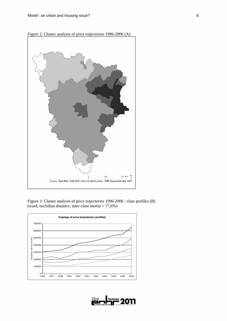
In the French context, the privatization of cities produced by the diffusion of secluded subdivisions have also been described, and many occurrences of municipal officials subordinated to the wishes and desires of home owners associations have been described near Paris, where the diffusion of private residential estates has been a classical feature of suburban areas since the late 19th century (Callen, 2002, Callen and Le Goix, 2007). At last, residential enclosures are spreading in the Paris region, emphasizing an individual search for security and a collective protection against the “others” (Charmes, 2005, Charmes, 2009). This diffusion of residential seclusion is partially the result of the adoption in Europe, in different forms of housing types, of P. Newman’s planning principles, defined in 1972 under the hypothesis of neighborhoods as “defensible spaces” (Le Goix and Loudier-Malgouyres, 2004). New Urbanism and defensible spaces theories have contributed to the diffusion of innovative morphologies in the 1970s, such as the cul-de-sacs or the loops (Newman, 1996, Newman, 1972). Other morphological studies on suburbia that have highlighted the prevalence of enclave morphologies (Lang and Lefurgy, 2007, Lang et al., 2006, Southworth and Owens, 1993). They are, among other, the results of local regulation that demonstrate the changing nature of the suburb, where enclosures are developing at different geographical levels : small municipalities looking for isolation and protection of their “lifestyle”, restrictive zoning, permanent search for social pairing by the means of school districts (and “school-maps” in France). A spatial analysis of change at the municipal level The main data source used to analyze single family houses in subdivisions (detached or semi-detached) has been extracted from a database of real-estate transactions in Ile-de-France provided by the Paris Chamber of Notaries (BIEN database). The extraction contains 7936 transactions between 1996 and 2006 in the Yvelines department, along with many variables describing the price, the characteristics of the sold property, along with the characteristics of sellers and buyers (age, description of his place of residence, social and occupational status). It is of importance to mention that some information in this database are based on voluntary feedback from the local notaries. If the quality of variables fluctuates, but it has considerably improved over the 10 years covered by our sample : as a consequence, the number of transaction per year has expanded from 463 in 1996 to 913 in 2006, and describes on the one hand the improving quality of the database and on the other hand the raw increase in transactions in the area and the dynamism of this suburban market. In addition, the geocoding of the original database has been found to be imprecise; new geocoding with accurate location information down to street address precision has been performed for the aim of this research. Increased property values, and increased inequalities In order to produce an analysis of price trajectories, it has been necessary to produce a consistent image of property price growth between 1996 and 2006 : we focus on the full property price, as property acreage and built surfaces introduce too much heterogeneity in the dataset to accurately compute price per sq. meters. Smoothing Inverse Distance Weighting has been used on a grid to produce an image of the unequal distribution of property value growth. These techniques are designed to convert discrete spatial information (property prices) into tendency surface, thus allowing to extrapolate the potential price for each cell on a grid. As in Figure 1, the waves of valorization throughout the decade thus appear to be structured by the core-peripheral price gradient. Another step of the analysis therefore consists in summarizing the local trends at the municipal level, in order to generalize the price information at the proper geographical level for subsequent analysis. This has been realized by the means of a cluster analysis of average property values at the municipal level for each year (average weighted mean of cells contained or intersected by municipal boundaries). The resulting typology (Erreur ! Source du renvoi introuvable. and Erreur ! Source du renvoi introuvable.) summarizes the most significant trends of property values by municipalities : very slow growth (indeed relative decline), slow growth, fast growth and very fast growth of values. This typology will be used to analyze the local context of property value increase in which the different kinds of subdivisions are located in.
5 Workshop 23: Housing and Cities - Changing Social and Spatial Boundaries
A first area of fast increase of price corresponds to the eastern edge of the department, in the vicinity of the western “beaux quartiers” of the western side of Paris, along with several amenities, such as the Chateau de Versailles and its park and forests (East), the national forest of Saint-Germain-en-Laye (NE). A bubble of valorization clearly emerges in the “Plaine de Versailles” and gets a considerable extension westward. Another area of valorization emerges from the semi-rural or exurban subdivisions located in the Valley de Chevreuse (ESE) and extends towards Montfort-l’Amaury, almost in the center of the department. Nevertheless, due to an industrial economical context, the northern perimeter of the Yvelines, along the Seine river, always get the lowest property values recorded in the department, therefore being affected by a trajectory of relative decline of values, everything else being equal. This unequal increase of property values change has been fueled by the changes in the local polycentricism of metropolitan activities. Whereas the Seine valley remains a powerful cluster of manufacturing and automotive industries, as well as a cluster of logistic activities (transportation, warehousing…), the rest of the department has been highly transformed under the influence of the La Défense high-rise business district and nearby clusters of businesses, headquarters, schools and university, and activities in the Saint-Quentin-en-Yvelines New Town1. These polycentric locations of TIC, business and management activities, financial and BtoB services, associated with post-industrial changes, have considerably modified the socio-economic profile of residents on the western side of Paris metropolitan region. Figure 1. The unequal distribution of property values growth
1 New Towns, planned after 1965, have been set up through a national wide project under the supervisions of the
State and the government (DATAR , an Agency for Regional Policy). Land policy of New Towns, as well as master-planning, has been in charge of public development corporations (Etablissements Publics, such as EPA-Marne & EPA-France in Marne-la-Vallée New Town) ; implementation and local authority being transferred from municipalities to a supra-municipal district composed by a board of locally elected officials from the incorporated municipalities (Syndicat d’Agglomération Nouvelle).
‘Mixité’: an urban and housing issue? 6
Figure 2. Cluster analysis of price trajectories 1996-2006 (A)
Figure 3. Cluster analysis of price trajectories 1996-2006 : class profiles (B) (ward, euclidian distance, inter-class inertia = 77,6%)
7 Workshop 23: Housing and Cities - Changing Social and Spatial Boundaries
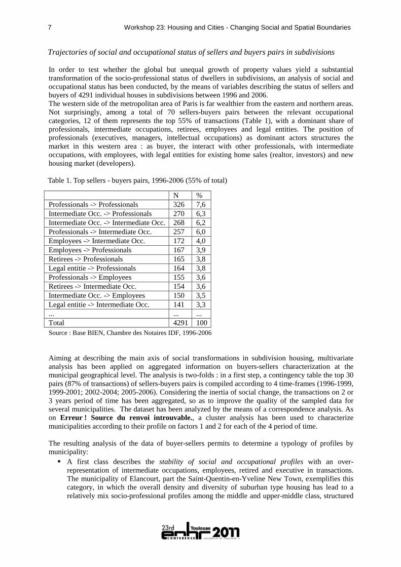
Trajectories of social and occupational status of sellers and buyers pairs in subdivisions In order to test whether the global but unequal growth of property values yield a substantial transformation of the socio-professional status of dwellers in subdivisions, an analysis of social and occupational status has been conducted, by the means of variables describing the status of sellers and buyers of 4291 individual houses in subdivisions between 1996 and 2006. The western side of the metropolitan area of Paris is far wealthier from the eastern and northern areas. Not surprisingly, among a total of 70 sellers-buyers pairs between the relevant occupational categories, 12 of them represents the top 55% of transactions (Table 1), with a dominant share of professionals, intermediate occupations, retirees, employees and legal entities. The position of professionals (executives, managers, intellectual occupations) as dominant actors structures the market in this western area : as buyer, the interact with other professionals, with intermediate occupations, with employees, with legal entities for existing home sales (realtor, investors) and new housing market (developers). Table 1. Top sellers - buyers pairs, 1996-2006 (55% of total)
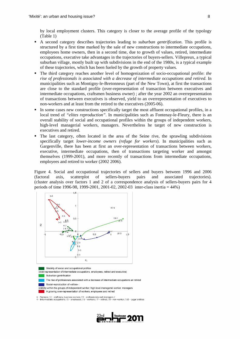
N % Professionals -> Professionals 326 7,6 Intermediate Occ. -> Professionals 270 6,3 Intermediate Occ. -> Intermediate Occ. 268 6,2 Professionals -> Intermediate Occ. 257 6,0 Employees -> Intermediate Occ. 172 4,0 Employees -> Professionals 167 3,9 Retirees -> Professionals 165 3,8 Legal entitie -> Professionals 164 3,8 Professionals -> Employees 155 3,6 Retirees -> Intermediate Occ. 154 3,6 Intermediate Occ. -> Employees 150 3,5 Legal entitie -> Intermediate Occ. 141 3,3 ... ... ... Total 4291 100 Source : Base BIEN, Chambre des Notaires IDF, 1996-2006 Aiming at describing the main axis of social transformations in subdivision housing, multivariate analysis has been applied on aggregated information on buyers-sellers characterization at the municipal geographical level. The analysis is two-folds : in a first step, a contingency table the top 30 pairs (87% of transactions) of sellers-buyers pairs is compiled according to 4 time-frames (1996-1999, 1999-2001; 2002-2004; 2005-2006). Considering the inertia of social change, the transactions on 2 or 3 years period of time has been aggregated, so as to improve the quality of the sampled data for several municipalities. The dataset has been analyzed by the means of a correspondence analysis. As on Erreur ! Source du renvoi introuvable., a cluster analysis has been used to characterize municipalities according to their profile on factors 1 and 2 for each of the 4 period of time. The resulting analysis of the data of buyer-sellers permits to determine a typology of profiles by municipality:
� A first class describes the stability of social and occupational profiles with an over-representation of intermediate occupations, employees, retired and executive in transactions. The municipality of Elancourt, part the Saint-Quentin-en-Yveline New Town, exemplifies this category, in which the overall density and diversity of suburban type housing has lead to a relatively mix socio-professional profiles among the middle and upper-middle class, structured
‘Mixité’: an urban and housing issue? 8
by local employment clusters. This category is closer to the average profile of the typology (Table 1)
� A second category describes trajectories leading to suburban gentrification. This profile is structured by a first time marked by the sale of new constructions to intermediate occupations, employees home owners, then in a second time, due to growth of values, retired, intermediate occupations, executive take advantages in the trajectories of buyers-sellers. Villepreux, a typical suburban village, mostly built up with subdivisions in the end of the 1980s, is a typical example of these trajectories, which has been fueled by the growth of property values.
� The third category reaches another level of homogenization of socio-occupational profile: the rise of professionals is associated with a decrease of intermediate occupations and retired. In municipalities such as Montigny-le-Bretonneux (part of the New Town), at first the transactions are close to the standard profile (over-representation of transaction between executives and intermediate occupations, craftsmen business owner) ; after the year 2002 an overrepresentation of transactions between executives is observed, yield to an overrepresentation of executives to non-workers and at least from the retired to the executives (2005-06).
� In some cases new constructions specifically target the most affluent occupational profiles, in a local trend of “elites reproduction”. In municipalities such as Fontenay-le-Fleury, there is an overall stability of social and occupational profiles within the groups of independent workers, high-level managerial workers, managers. Nevertheless he target of new construction is executives and retired.
� The last category, often located in the area of the Seine rive, the sprawling subdivisions specifically target lower-income owners (refuge for workers). In municipalities such as Gargenville, there has been at first an over-representation of transactions between workers, executive, intermediate occupations, then of transactions targeting worker and amongst themselves (1999-2001), and more recently of transactions from intermediate occupations, employees and retired to worker (2002 2006).
Figure 4. Social and occupational trajectories of sellers and buyers between 1996 and 2006 (factoral axis, scatterplot of sellers-buyers pairs and associated trajectories). (cluster analysis over factors 1 and 2 of a correspondence analysis of sellers-buyers pairs for 4 periods of time 1996-98, 1999-2001, 2001-02, 2002-03 inter-class inertia = 44%)
9 Workshop 23: Housing and Cities - Changing Social and Spatial Boundaries
Figure 4. Typology of social and occupational trajectories of sellers and buyers (map)
Street patterns and social change: interactions, spatial associations and contextual effects This section elaborates on the resulting typologies in order to test whether the different types of street patterns correlates with the housing price structure at the municipal level over time (1996-2006); and to what extent dominant street patterns and residential morphologies relate to social change, analyzed in terms of seller-buyers characteristics, at the municipal level. An analysis of street patterns in subdivisions The spatial analysis of suburban morphologies has originally been based upon an exploratory set of data on residential enclaves in planned unit developments on suburban areas developed between 1982 and 2003 in Ile-de-France, courtesy of the IAU-IdF (Loudier-Malgouyres, 2010). Additional units have been surveyed so as to improve the quality of the sample in the Yvelines department (Huet, 2009). Based upon aerial photographical interpretation, land use and local road network analysis, so a to analyze the level of severance, a total of 490 residential secluded planned unit developments have been surveyed in a representative sample of 71 municipalities in the suburban areas of the metropolitan region in order to study the severance and morphological patterns in the environment of residential planned unit developments. The surveyed municipalities have been chosen in order to render the diversity of suburban settlement patterns: suburbs, contemporary urban fringe, new towns, exurbs in rural areas). Residential enclaves have indeed been described according to the characteristics of the inner local road networks (number of arcs, nodes, dead-ends, access points, node density, segment density, total length of the network). On the basis of network analysis tools, three major
‘Mixité’: an urban and housing issue? 10
street patterns have been extracted and analyzed, describing the most common layout following new urbanism and defensible space residential planning theories. As many suburban developments combine the three basic elements, the most common during the last 30 years being the “loops and lollipops” layout, an intricate combination of many loops, cul-de-sacs and lollipops (Southworth, Owens, 1993), the typology of street patterns has been established distinguishing 4 mains types, summarized in Table 2. Table 2. A typology of subdivisions by street patterns.
Type 1. Hierarchical network - tree structure
Type 2. Dead-ends / culs-de- sac
Type 3. Simple loops
Type 4. Combination of loops and lollipops
Example Les Coudrays Maurepas
Le Berceau, Elancourt
Bonnières-sur-Seine
La Bretonnière, Voisins le Bretonneux
Average surface (sq. m.)
26,000 15,200 24,364 79,496
Std. dev. of surface
16,301 13,066 18,816 101,406
Number of subdivisions
149 155 55 131
Sources : IAU-IdF ; IP4 datasets, UMR Géographie-cités 8504, 2010. Aerial photograph : Google Earth, 2011. Methodology : Loudier-Malgouyres, C. (2010) L'enclavement et la fermeture des ensembles d'habitat individuel Première approche à partir des aspects morphologiques en Ile-de-France. Published report. IAU-IdF, Paris [online:http://www.iau-idf.fr/fileadmin/Etudes/etude_755/L_enclavement_et_la_fermeture_des_ensembles_d_habitat_individuel.pdf, last access 12/2010] Figure 2. Changing trends in street patterns in secluded subdivisions in the Yvelines Sources : Base BIEN, Chambre des Notaires 1996-2006 ; IAU-IdF ; IP4 datasets, UMR Géographie-cités 8504, 2010.
11 Workshop 23: Housing and Cities - Changing Social and Spatial Boundaries
Although a dominant morphology in suburban landscape, the production of individual housing in the area has considerably decreased during the last 30 years. 64% of the houses in the surveyed subdivisions have been built between 1981 and 1991, 26% between 1992 and 2000, and only 6% after 2001. This decline of the production in absolute value has been followed by a relative decline of complex street patterns (loops and lollipops), therefore yielding a diffusion of simpler street patterns in early 1990s, and also the growth of cul-de-sac layout in smaller in-fill developments (Erreur ! Source du renvoi introuvable.). More recent trends are therefore more diverse in terms of street patterns, because land opportunities oblige developers to built within cluster development zones, in which in-fill developments require more flexible designs: simple loops and cul-de-sac patterns are found in the newer parts of the suburban development, highly affected by new state regulations after 2000 that have set new standards and requirements of social mix in large scale residential projects (public housing) and a priority towards higher densities and in-fill developments within suburban areas by the means of legal restriction on zoning so as to avoid urban sprawl and consumption of agricultural lands (SRU law, December 2000, standing for solidarities and urban renewal laws). Street patterns and residential morphology in the context of social change The relationships between street patterns and property value and socio-professional change is now addressed in terms of local context. The price and socio-occupational profiles of discrete transactions made in single-family housing in subdivisions and planned development have indeed been aggregated, therefore averaged, at the municipal level. The results are analyzed in order to document how the local contexts have a measurable spatial association with street patterns and urban morphology. This does not have any meaning in terms of causality, but highlights the coherence of strategies of planners, developers, municipalities, in terms of morphological choices. This methodology is used as a means to analyze the complex and intricate play between actors of the suburban growth machine at the local scale, in terms of how morphologies are “somehow” associated with urban change. The results are compiled in order to test whether the different types of street patterns correlate with the housing price structure of housing in subdivisions averaged at the municipal level over time (1996-2006) ( Table 3). Both typologies are not independent (based on chi-square test). simpler street patterns are more likely to be found in areas of very slow growth of and to what extent dominant street patterns and residential morphologies relate to social change, analyzed in terms of seller-buyers characteristics, at the municipal level. Complex street layouts belong to price valorization contexts that are clearly distinguishable: on the one hand, tree structure subdivisions, often covering large surfaces and in contact with forest and agricultural land-use (Le Goix, 2009), are more likely to be found in areas of median and fast growth, whereas on the other hand, loops and lollipops street patterns are more likely to be found in “slow growth” areas. Simple street patterns show a more fuzzy behavior : whereas simple loops are clearly more likely to be found in areas of very slow growth and slow growth (relative depreciation), and have clear risk to be associated with suburban decay, subdivisions with dead-ends patterns may adopt contrasting locations. They might be more likely to be found in very slow growth areas (47.3%), but are also significantly found in areas of fast and very fast growth. Table 3. Contingency table : property price growth and street patterns
% Very slow growth Slow growth Fast growth Very fast growth Total Tree structure 22.7 33.2 31.6 30.6 30.4 Dead-ends 47.3 22.1 39.5 41.9 31.6 Simple loops 11.8 12.5 10.5 4.8 11.2 Loops and lollipops 18.2 32.1 18.4 22.6 26.7 Total 100 100 100 100 100
‘Mixité’: an urban and housing issue? 12
N=490, Chi-Sq = 32.339, DF = 9, P-Value = 0.00017 at alpha=.01 (Very significant). The values displayed in bold are significant at the level alpha=.05 Source : Base BIEN, Chambre des Notaires de Paris, 1996-2006 Table 4. Contingency table : seller-buyer trajectories and street patterns
% Stability Reproduc-tion of elites
Suburban gentrification
Refuge for workers
Professionals
Total
Loops and lollipops
39.5 35.7 14.7 5.4 4.7 100
Simple loops
42.3 21.2 17.3 7.7 11.5 100
Dead-ends 32.2 23.8 16.8 14.0 13.3 100 Tree structure
47.6 25.9 16.8 4.2 5.6 100
Total 40.0 27.4 16.3 7.9 8.4 100
N=467, Chi-Sq = 27.710, DF = 12, P-Value = 0.006 at alpha=.01 (Very significant). The values displayed in bold are significant at the level alpha=.05 Source : Base BIEN, Chambre des Notaires de Paris, 1996-2006 Pushing further the analysis with a comparison between street patterns and seller-buyer trajectories, we not only associate morphology with price valorization, but also introduce in the analysis some information about the changing socio-occupational characteristics accompanying the price change (Table 4). Because of the average trends in the Yvelines, the stability of socio-occupational profiles best describe a majority of subdivisions, whatever their morphology. This is for instance the case in Buchelay (Figure 7) where new secluded subdivision, built up as small in-fill schemes affiliated to New Urbanism references, highly contrast with the inherited landscape where lower density hierarchical patterns have once been dominant. The density and the size of the houses permit a stability of the price and consequently a maintain of the social structure, with arbitrage on the price of land (no gardens) and density. Figure 3. A recent loop-type subdivision in Buchelay, in a context of stability of social and occupational profiles (trajectory type 1 : stability with an over-representation of intermediate occupations, employees, retired and professionals)
Source : Huet, 2009
13 Workshop 23: Housing and Cities - Changing Social and Spatial Boundaries
Nevertheless, the interpretation of significant overrepresentation in (Table 4) shows clear association between trajectories and morphologies. - An over-representation of “loops and lollipops” is clearly associated with stability and the
reproduction of the socio-professional elites. Located for instance in the Versailles flatlands, these are large subdivisions, located nearby golf courses and amenities, in very homogeneous environment. Saint-Nom-la-Bretèche has several “loop and lollipop on a stick” schemes, on the fringe of the metropolitan area (Erreur ! Source du renvoi introuvable.). Newer developments follow the same patterns than older (1970s) and larger planned subdivisions in the area. Located nearby a golf course, this development maximizes its location rent, as it benefits from a high accessibility to the downtown area and suburban business districts. The enclave morphology of loops is related to high level of property price and a strong homogeneity of the social level of the owners.
Figure 8. A high-end “faux-gated” development in Saint-Nom-la-Bretèche (loop street pattern, trajectory type 4 : social reproduction of the “elites”)
Source : Huet, 2009 - Subdivision with hierarchically organized street patterns (arranged like a tree) belong to a very
typical stable socio-occupational profile. There are many reasons for this peculiar behavior: for the same reasons than “loops and lollipops”, they are large developments, more likely to be built nearby immutable land-uses, which are quite common in the area (amenities, patrimonial forest, golf courses, water bodies). Requiring a large availability of land, this kind of subdivision represents a quasi monopolistic share of residential land-use in a given area. The shape of street patterns allow a better contact with open space and amenities (Table 2), and no other development can be built in the close vicinity therefore favoring an overall stability of the built environment. All these characteristics, in a context of property price growth within the average trends (
- Table 3) play together towards a high level of stability.
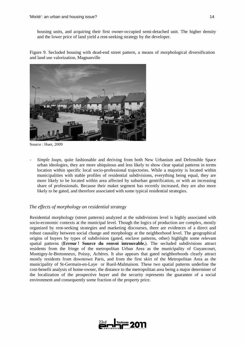
- The dualism of environment best describing the peculiarity of subdivisions in dead-end patterns : they are either overrepresented in municipalities where subdivision builders have been targeting lower-income owners (refuge for workers), or in municipalities with an increasing share of professionals and higher-income owners. These are often used in order to increase the density of built-up areas, and the seclusion of dead-end is a useful feature to maintain an appealing residential environment within a context of very diverse land-use. For instance, recent dead-ends subdivision residential non-gated enclave (Figure 9) developed by the international developer Nexity in Magnanville (next to Mantes-la-Jolie). This very dense program is located in a relatively depreciated area, next to industries, warehouses and social housing in the Seine Valley. This housing product targets the lower middle class, previously living in rental multi-family
‘Mixité’: an urban and housing issue? 14
housing units, and acquiring their first owner-occupied semi-detached unit. The higher density and the lower price of land yield a rent-seeking strategy by the developer.
Figure 9. Secluded housing with dead-end street pattern, a means of morphological diversification and land use valorization, Magnanville
Source : Huet, 2009 - Simple loops, quite fashionable and deriving from both New Urbanism and Defensible Space
urban ideologies, they are more ubiquitous and less likely to show clear spatial patterns in terms location within specific local socio-professional trajectories. While a majority is located within municipalities with stable profiles of residential subdivisions, everything being equal, they are more likely to be located within area affected by suburban gentrification, or with an increasing share of professionals. Because their maket segment has recently increased, they are also more likely to be gated, and therefore associated with some typical residential strategies.
The effects of morphology on residential strategy Residential morphology (street patterns) analyzed at the subdivisions level is highly associated with socio-economic contexts at the municipal level. Though the logics of production are complex, mostly organized by rent-seeking strategies and marketing discourses, there are evidences of a direct and robust causality between social change and morphology at the neighborhood level. The geographical origins of buyers by types of subdivision (gated, enclave patterns, other) highlight some relevant spatial patterns (Erreur ! Source du renvoi introuvable.). The secluded subdivisions attract residents from the fringe of the metropolitan Urban Area as the municipality of Guyancourt, Montigny-le-Bretonneux, Poissy, Achères. It also appears that gated neighborhoods clearly attract mostly residents from downtown Paris, and from the first skirt of the Metropolitan Area as the municipality of St-Germain-en-Laye or Rueil-Malmaison. These two spatial patterns underline the cost-benefit analysis of home-owner, the distance to the metropolitan area being a major determiner of the localization of the prospective buyer and the security represents the guarantee of a social environment and consequently some fraction of the property price.
15 Workshop 23: Housing and Cities - Changing Social and Spatial Boundaries
Figure 10. Geographical origins of buyers by level of residential seclusion (all transactions ; transactions in secluded subdivisions; transactions in gated communities)
Source : Huet, 2009 This is for instance the case of a recent gated communities located in the municipality of Vernouillet (Erreur ! Source du renvoi introuvable.. This small scheme of about 15 houses is typical of the limited number of single family owner-occupied gated communities built in Ile-de-France (64 subdivisions only, according to a recent study by the Regional Planning Agency IAU) (Loudier-Malgouyres and Vallet, 2010). Located nearby a large hierarchized (tree-structure) street pattern housing enclosure of 279 properties built in the 1974, this new morphological strategy based on density and gating is likely to interfere with the local social structure with an increase of the share of professional associated and a decrease of intermediate occupations and retired, attracting prospective buyers from the downtown Paris or from the wealthier north-eastern side of the Yvelines. And gated communities, although in small number, are seen as a very powerful tool to attract lower-income prospective buyers in a built environment that offers a sense of security and positive amenities. For instance a Kaufman and Broad subdivision built in Bonnières-sur-Seine of 100 properties has been developed on former agricultural land-use (Figure 12). The owners are mainly workers, employees and retired set aside by the increase of property values in the rest of the suburban areas. The architecture is minimalist and standardization has been a major criteria for the lower prices. This kind of scheme represents the new edges of the urban sprawl and his consequences on the consumption of agricultural area. Figure 11. Smaller and gated new products in Vernouillet targeting professionals (street pattern : loop and lollipops; trajectory type 3 : A growing over-representation of professionals)
‘Mixité’: an urban and housing issue? 16
Source : Huet, 2009 Figure 12. Sprawling subdivisions on the far-western side (Bonnières): the last refuge for lower-income owners (trajectory type 5 : a growing over-representation of workers, employees and retired)
Source : Huet, 2009 Conclusion This joint analysis of the local environment (or neighborhood effects) of price and socio-occupational changes with residential street patterns in subdivisions yield three major conclusions. First, though not surprising per se, the analysis confirm there is a strong relation between the types of morphologies and the patterns of socio-occupational changes driven by property value : some clear spatial associations appear, such as between hierarchical street networks and overall stability of social profiles, between “loops and lolippops” and “the reproduction of elites”, or between simple loops and “suburban gentrification”. Second, it must be reminded that the stronger variable for differentiating subdivisions remains the age of a neighborhood (Erreur ! Source du renvoi introuvable.) : suburbia yields stronger generational effects on socio-economic patterns than inner cities areas. And this give way to strong effects on socio-occupational categories targeted by some products. For instance, the newer gated and loop-type neighborhoods are clearly associated with professionals and suburban gentrification, and have also sound and clear spatial patterns in terms of residential strategies of prospective buyers leaving the central areas for the suburbs. To what extent these spatial associations are clues of a potential direct causality between morphologies and preferences by some subsets of the single housing prospective buyers will remain an out of scope question for this paper for obvious ecological fallacy reasons ; nevertheless, it clearly appears that some local planning or location contexts clearly affects morphological choices. This
17 Workshop 23: Housing and Cities - Changing Social and Spatial Boundaries
research highlights the multi-scalar issues that are to be analyzed in order to get a better understanding of social and spatial change on the urban edge and its intricate context, geographical levels and strategies : residential morphology, rent-seeking strategies at different geographical levels, neighborhood street patterns and developers planning strategy, municipal trajectories, regional planning. Acknowledgements Researches for this paper have been founded by the ANR (French National Reseach Agency, http://www.agence-nationale-recherche.fr/Intl), under the IP4 2007-2010 research program (Public-Private Interactions in the Production of Suburban areas, http://gated.parisgeo.cnrs.fr/). The authors whishes to acknowledge and thank the IAU-IdF, Antonin Gosset and Céline Loudier-Malgouyres, principal investigators for the database on residential enclaves in Ile-de-France used as a primary source in this paper. References Ascher, F. (1995) Métapolis, ou l'avenir des villes Paris: Odile Jacob. Berger, M. (2004) Les périurbains de Paris Paris: CNRS Editions. Berroir, S., Mathian, H., et al. Les pôles de l'activité métropolitaine. Saint-Julien Th., Le Goix R., La métropole
parisienne. Centralités, inégalités, proximités. Belin, pp 11-38. Berroir, S., Mathian, H., et al. Navettes et disjonction sociale dans une métropole multipolaire. Saint-Julien T.,
Le Goix R., La métropole parisienne. Centralités, inégalités, proximités. Belin, pp 89-109. Billard, G., Chevalier, J., et al. (2005) Ville fermée, ville surveillée : La sécurisation des espaces résidentiels en
France et en Amérique du Nord Rennes: Presses Universitaires de Rennes (coll. Géographie sociale). Bordreuil, J.-S. (2000) La ville desserrée. La ville et l'urbain. L'état des savoirs. Editions La Découverte, Paris,
pp 169-180. Burgel, G. (1989) La ville fragmentée : le lotissement d'hier et d'aujourd'hui Nanterre: Laboratoire de
géographie urbaine (coll. Villes en parallèle). Callen, D. (2002) Espaces publics, espaces privés: conception et pratique des nouveaux espaces résidentiels.
Département de Géographie. Paris: Université Paris 1 Panthéon-Sorbonne (dir. Pr. Th. Saint-Julien). Callen, D. & Le Goix, R. (2007) Fermeture et entre-soi dans les enclaves résidentielles. In Saint-Julien, T. & Le
Goix, R. (Eds.) La métropole parisienne. Centralités, Inégalités, Proximités. Belin (Mappemonde), Paris, pp pp. 209-232.
Calvet, M. (2010) Coûts et avantages des différentes formes urbaines – Synthèse de la littérature économique.
coll. Etudes et Documents. Paris: Service de l’Economie, de l’Evaluation et de l’Integration du Développement Durable du Commissariat Général au Développement Durable.
Cervero, R. (1989) America's Surburban Centres : the Land Use Transportation Links London: Unwin-Hyman. Cervero, R. & Kang-Li, W. (1998) Sub-centring and Commuting: Evidence from the San Francisco Bay Area,
1980-90. Urban Studies, 35 (7): 1059-1076. Charmes, E. (2005) La Vie périurbaine face à la menace des "gated communities" Paris: L'Harmattan. Charmes, E. (2009) On the Residential `Clubbisation' of French Periurban Municipalities. Urban Studies, 46 (1):
189-212.
‘Mixité’: an urban and housing issue? 18
Charmes, E. (2010) Cul-de-sacs, Superblocks and Environmental Areas as Supports of Residential
Territorialization. Journal of Urban Design, 15 (3): 357-374. Comby, J. (2010) Les six marchés fonciers, une approche des logiques de formation de la valeur L’Observateur
Immobilier, 75 (dec 2009-Jan 2010). Davis, J. S., Nelson, A. C., et al. (1994) The New 'Burbs: the Exurbs and their Implications for Planning Policy.
Journal of American Planning Association, 60 (1): 45-59. Donzelot, J. & Jaillet, M.-C. (2000) La nouvelle question urbaine. Actes du séminaire, mai 1999-juin 2000.
Paris: Ministère de l'équipement, des transports et du logement, Secrétariat d'Etat au logement, PUCA, 2001.
Donzelot, J. & Mongin, O. (1999) De la question sociale à la question urbaine. Esprit, (258): 83-86. Dubois-Taine, G. & Chalas, Y. (1997) La ville émergente La Tour d'Aigues: Editions de l'Aube (Coll. Monde
en cours. Société). Foldvary, F. (1994) Public Goods and Private Communities: the Market Provision of Social Services Aldershot:
Edward Elgar. Fourcaut, A. (Ed.) (1988) Un siècle de banlieue parisienne (1859-1964) Paris: L'Harmattan (ville et
entreprise). Glasze, G. (2005) Some Reflections on the Economic and Political Organisation of Private Neighbourhoods.
Housing Studies, 20 (2): 221 - 233. Huet, A. (2009) Les nouveaux produits immobiliers dans les espaces périurbains, entre logiques foncières et
aspirations individuelles. Master 1 dissertation (R. Le Goix, supervisor). Paris: Univ. Paris 1 Panthéon-Sorbonne.
Jaillet, M.-C. (1999) Peut-on parler de sécession urbaine à propos des villes européennes ? Esprit, 11 (258,
Novembre 1999): 145 - 167. Lang, R. & Lefurgy, J. B. (2007) Boomburbs : the rise of America's accidental cities Washington, D.C.:
Brookings Institution Press. Lang, R., Lefurgy, J. B., et al. (2006) The Six Suburban Eras of the United States. Research Note. Opolis: An
International Journal of Suburban and Metropolitan Studies, 2 (1): Article 5. Le Goix, R. (2009) Suburbs, boomburbs and exurbs : a multilevel approach of contextual effects and the
production of suburban morphologies. Methodological framework and exploratory results in Paris metropolitan region. 5th International Conference of the Research Network Private Urban Governance & Gated Communities (Redefinition of Public Space Within the Privatization of Cities). . University of Chile, Santiago, Chile, March 30th - April 2nd 2009.
Le Goix, R. & Loudier-Malgouyres, C. (2004) L'espace défendable aux Etats-Unis et en France. Urbanisme,
(337 (juillet-août 2004)): pp. 51-56. Le Goix, R. & Webster, C. J. (2008) Gated Communities. Geography Compass, 2 (4): 1189-1214. Loudier-Malgouyres, C. (2010) L'enclavement et la fermeture des ensembles d'habitat individuel Première
approche à partir des aspects morphologiques en Ile-de-France. Published report. Paris: IAU-IdF. Loudier-Malgouyres, C. & Vallet, B. (Eds.) (2010) L'influence de la sécurité sur la conception urbaine Paris:
Institut d'Aménagement et d'Urbanisme Région Ile-de-France - IAU. Mckenzie, E. (1994) Privatopia: Homeowner Associations and the Rise of Residential Private Government New
Haven (Conn.) ; London: Yale University Press.
19 Workshop 23: Housing and Cities - Changing Social and Spatial Boundaries
Mckenzie, E. (2003) Common interest housing in the communities of tomorrow. Housing Policy Debates, 14 (1-
2): 203-234. Montserrat Farguell, I. & Grandval, V. (Eds.) (1998) Hameaux, villas et cités de Paris Paris: Action artistique
de la ville de Paris. Newman, O. (1972) Defensible Space: Crime prevention through Urban Design New York: MacMillan. Newman, O. (1996) Creating Defensible Space. Washington, D.C.: U.S. Department of Housing and Urban
Development, Office of Policy Development and Research, Institute for Community Design Analysis, Center for Urban Policy Research, Rutgers University.
Newman, O., Grandin, D., et al. (1974) The Private Streets of St. Louis. New York: A National Science
Foundation study, Institute for Community Design. Pollard, J. (2009) Political Framing in National Housing Systems: Lessons from Real-Estate Developers in
France and Spain. In Schwartz, H. & Seabrooke, L. (Eds.) The Politics of Housing Booms and Busts. Palgrave MacMillan, pp pp. 170-188.
Renard, V. (2003) Les enjeux urbains des prix fonciers et immobiliers. In Prager, J. C. (Ed.) Villes et économie.
La Documentation française, Paris, pp 95-108. Renard, V. (2008) La ville saisie par la finance. Le Débat, (148): 106-117. Southworth, M. & Owens, P. O. (1993) The Evolving Metropolis: Studies of Community Neighborhood and
Street Form at the Urban Edge. Journal of American Planning Association, 59 (3): 271-287. Topalov, C. (1974) Les Promoteurs immobiliers : contribution à l'analyse de la production capitaliste du
logement en France Paris, La Haye: Mouton. Wattine, D. (1990) Participation financière des lotisseurs. Etudes Foncières, (48 (septembre)): pp. 32-34. Webster, C. & Glasze, G. (2006) Dynamic urban order and the rise of residential clubs. In Glasze, G., Webster,
C., et al. (Eds.) Private Cities: local and global perspectives. Routledge, London, pp 222-236.