December 2012 SFR-087/12 The John Graves Scenic Riverway A Report to the 83rd Texas Legislature printed on recycled paper Office of Compliance and Enforcement TEXAS COMMISSION ON ENVIRONMENTAL QUALITY
Transcript
December 2012 SFR-087/12
The John Graves Scenic Riverway A Report to the 83rd Texas Legislature
printed on recycled paper
Office of Compliance and Enforcement
T E X A S C O M M I S S I O N O N E N V I R O N M E N T A L Q U A L I T Y
The John Graves Scenic Riverway: A Report to the 83rd Legislature
Prepared by Office of Compliance and Enforcement
SFR-087/12 December 2012
ii
Published and distributedby the
Texas Commission on Environmental QualityPO Box 13087
Austin TX 78711-3087
Bryan W. Shaw, Ph.D., ChairmanCarlos Rubinstein, Commissioner
Toby Baker, Commissioner
Zak Covar, Executive Director
We authorize you to use or reproduce any original material contained in this publication—that is, any material we did not obtain from other sources. Please acknowledge the TCEQ as your source.
Copies of this publication are available for public use through the Texas State Library, other state depository libraries, and the TCEQ Library, in compliance with state depository law. For more information on TCEQ publications call 512-239-0028 or visit our website at:
tceq.texas.gov/publications
The TCEQ is an equal opportunity employer. The agency does not allow discrimination on the basis of race, color, religion, national origin, sex, disability, age, sexual orientation or veteran status. In compliance with the Americans with Disabilities Act, this document may be requested in alternate formats by contacting the TCEQ at 512-239-0028, Fax 512-239-4488, or 1-800-RELAY-TX (TDD), or by writing PO Box 13087, Austin, TX 78711-3087.
How is our customer service? tceq.texas.gov/customersurvey
The John Graves Scenic Riverway—A Pilot Program ............................................... 4 Scope of the Pilot Program .......................................................................................... 4 Rulemaking .................................................................................................................. 4
Looking Forward ......................................................................................................... 15 John Graves Scenic Riverway as a Pilot Program .................................................... 15 Ongoing Interagency Coordination—Inspections and Sampling ................................ 15
John Graves Scenic Riverway Boat Study ............................................................... 16
Appendix: John Graves Scenic Riverway and Water Quality Protection Area Map ........................................................................... 18
The John Graves Scenic Riverway: A Report to the 83rd Legislature TCEQ publication SFR-087/102
iv December 2012
December 2012 1
Purpose The 79th Texas Legislature enacted Senate Bill 1354, legislation creating the John Graves Scenic Riverway, and established a pilot program to enhance water quality protection by establishing specific regulations for quarries within the watershed. In keeping with the nature of the pilot program, the Texas Commission on Environmental Quality (TCEQ) has prepared this biennial report summarizing the implementation of this legislation. This is the fourth biennial report and focuses on the implementation of regulations adopted under SB 1354 and the effects of these rules on regulated quarry activities in the John Graves Scenic Riverway.
The John Graves Scenic Riverway: A Report to the 83rd Legislature TCEQ publication SFR-087/102
2 December 2012
Introduction Background
As demand for building and construction material has increased throughout Texas, the mining operations that supply these materials have developed and expanded in response to that demand. With the development and expansion of these operations, citizens have increasingly expressed concerns regarding the environmental impacts from these operations. The John Graves Scenic Riverway and its associated pilot program were developed in an effort to address water quality related environmental impacts from rock and sand and gravel mining (quarry) operations.
The TCEQ is the Texas state agency responsible for regulating and authorizing discharges from quarry operations under the National Pollutant Discharge Elimination System (NPDES) program, a comprehensive national program developed to protect water quality through regulation of wastewater and stormwater discharges. Most quarry operations are authorized to discharge stormwater under the Multi Sector General Permit (MSGP) for industrial activities. The MSGP establishes requirements for best management practices, inspections, effluent limitations, and monitoring requirements designed to minimize or prevent the discharge of pollutants in stormwater discharges from industrial activities, including quarry operations.
Following delegation of the stormwater component of the NPDES program to Texas in 2001, the TCEQ conducted outreach seminars and began conducting investigations in an effort to educate the regulated community about the requirements of the MSGP. Despite these efforts, the TCEQ discovered a lack of awareness and compliance with the MSGP through the Clear Streams Initiative. The TCEQ’s Clear Streams Initiative was a concentrated effort by a team of field investigators that examined 316 quarries in 62 counties over a four-week period beginning in April 2004. Although the Clear Streams Initiative revealed that noncompliance with the MSGP was a statewide issue and problem, it also revealed that the instances of noncompliance rarely resulted in significant detrimental effects to water quality.
Within Parker and Palo Pinto Counties, however, the TCEQ discovered that the type and nature of mining activities and the local topographical, geological, and geographical conditions resulted in impacts to water quality within the area now designated as the John Graves Scenic Riverway where stormwater permit conditions and best management practices were not being followed. As the TCEQ and other state agencies attempted to address and respond to citizen concerns regarding these water quality impacts, it became apparent that several state agencies possessed regulatory authority; however, none was positioned to address the water quality impacts from these operations comprehensively. The John Graves Scenic Riverway pilot program
TCEQ publication SFR-087/10 The John Graves Scenic Riverway: A Report to the 83rd Legislature
December 2012 3
focuses on addressing the water quality concerns associated with discharges of wastewater and stormwater from rock, sand or gravel mining operations.
Legislative Solution The concerns of local citizens and legislators about the authority to address the activities of quarries operating in sensitive areas led to the introduction and passage by the 79th Texas Legislature of Senate Bill 1354, authored by Senator Craig Estes of Wichita Falls and sponsored by Representative Jim Keffer of Eastland. The legislation established a new Subchapter M under Chapter 26 of the Texas Water Code (TWC) to protect the river and regulate quarries in the newly designated John Graves Scenic Riverway.
This legislation:
• Designates a portion of the Brazos River basin as the John Graves Scenic Riverway. • Establishes a pilot program for the protection of water quality through regulation
of wastewater and stormwater discharges from quarries, including requirements for financial assurance.
• Requires interagency coordination of inspections and sampling within the John Graves Scenic Riverway.
• Establishes enhanced enforcement authority and penalties. • Provides for cost recovery if the state is required to take action to correct
problems resulting from improper operation of quarries. During the 82nd Texas Legislative Session, House Bill 571 was authored by Representative Dan Huberty of Kingwood and Representative Rob Eisler of The Woodlands and coauthored by Representative Lyle Larson of San Antonio and Representative Ken Legler of Pasadena, and sponsored by Senator Tommy Williams of the Woodlands. The legislation required all aggregate production operations in the state to register annually. The new requirements were implemented in rules found in 30 Texas Administrative Code (TAC) Chapter 342. The legislation defined aggregates as materials used in construction, including sand, gravel, crushed and broken limestone or granite, dirt, soil, or caliche. Sites include those from which aggregates are being or have been removed or extracted from the earth, and land on which aggregates are processed. TCEQ will be required to inspect aggregate production operations once every three years. These new requirements will compliment the activities already occurring in the John Graves Scenic Riverway.
The John Graves Scenic Riverway: A Report to the 83rd Legislature TCEQ publication SFR-087/102
4 December 2012
The John Graves Scenic Riverway—A Pilot Program Scope of the Pilot Program
The pilot program established by 30 TWC, Chapter 26, Subchapter M, expires September 1, 2025. Until that time, the TCEQ is charged with developing and continually evaluating a wastewater and stormwater permitting program for quarries within the John Graves Scenic Riverway. The development and implementation of this program includes rulemaking activities, the development and issuing of a general permit, and issuing individual permits. Consistent with SB 1354, the rules, general permit, and individual permits establish regulatory requirements for quarry operations in proximity to rivers and streams that are tailored to the individual site and the risks associated with site-specific conditions.
The specific requirements of the legislation are as follows:
• Quarries located in a designated water quality protection area more than one mile from a water body must obtain a general permit.
• Quarries within one mile of a water body or within the 100-year floodplain of a water body must obtain an individual permit.
• New quarry operations or the expansion of existing operations located between 200 feet and 1,500 feet of a water body are prohibited, unless an applicant for an individual permit can demonstrate, and the TCEQ can substantiate, that certain specific requirements are satisfied. These include specific performance criteria established by the TCEQ, plans for control of erosion and protection of fish and wildlife habitat and public and private property, plans for reclamation of a quarry, and the use of best available technology.
• Unless otherwise exempted by the legislation, new quarry operations or the expansion of existing operations are prohibited within 200 feet of a water body within a water quality protection area designated by the TCEQ;
• Any permit issued under SB 1354, whether an individual permit or general permit, must satisfy effluent limits established by the TCEQ, requirements for financial assurance, and include a plan for restoration of receiving waters in the event of an unauthorized discharge.
Rulemaking The TCEQ implemented the permitting and financial responsibility components of this statute through rules in 30 TAC Chapter 311, Subchapter H and 30 TAC Chapter 37, Subchapter W. The final rules, reflecting the changes made in response to public comment and adopted by the Commission, became effective August 3, 2006.
TCEQ publication SFR-087/10 The John Graves Scenic Riverway: A Report to the 83rd Legislature
December 2012 5
30 TAC Chapter 311, Subchapter H primarily implements the permitting components of the statute. The subchapter also establishes the financial assurance requirements for restoration and reclamation. Generally, the structure of Subchapter H follows that of the statute so that the organization and requirements of each relate better when compared side by side. The major requirements of the rule are grouped into sections, titled as follows:
• Definitions • Applicability • Prohibitions • Authorization • Permit Application Requirements • Restoration Plan • Technical Demonstration • Reclamation Plan • Performance Criteria for Quarries Located Within a Water Quality Protection Area
in the John Graves Scenic Riverway • Additional Performance Criteria for Quarries Located Between 200 Feet and 1,500
Feet of a Water Body Located Within a Water Quality Protection Area in the John Graves Scenic Riverway
• Financial Responsibility for Quarries Located Within a Water Quality Protection Area in the John Graves Scenic Riverway
• Existing Quarries Chapter 37, Subchapter W, implements the financial assurance components of
the statute. The subchapter outlines administrative procedures and requirements related to the types of available financial assurance.
Definitions
The specialized terms used within the subchapter are incorporated into this section of Chapter 311, Subchapter H. With the exception of “navigable” and “water quality protection area,” definitions are consistent with new TWC, Chapter 26, Subchapter M; other subchapters of 30 Texas Administrative Code; or 40 Code of Federal Regulations. Definitions for “navigable” and “water quality protection area” determine the applicability of specific provisions within the statute and are discussed separately below.
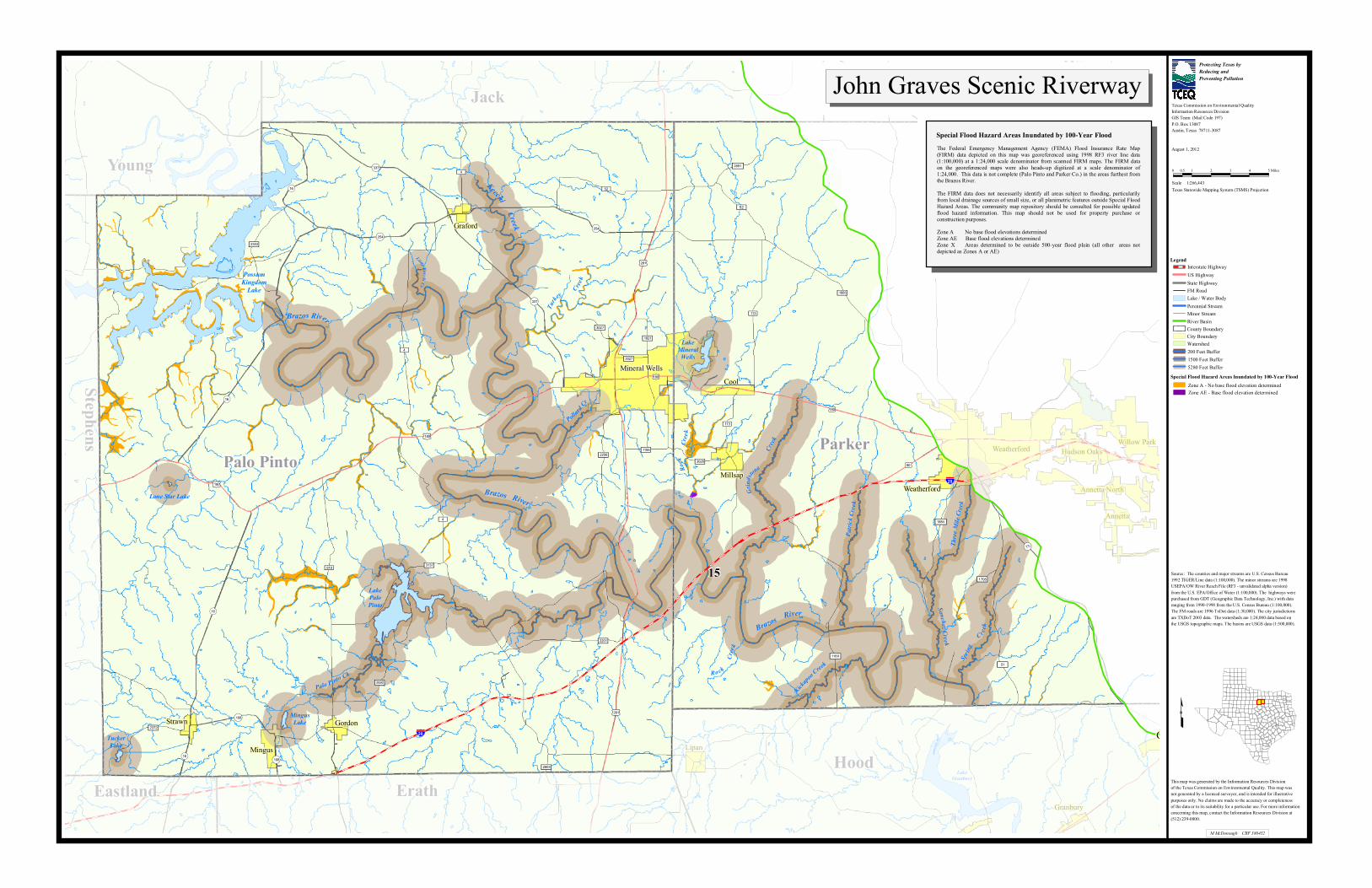
The jurisdiction of SB 1354 is defined first as the John Graves Scenic Riverway and then as a water quality protection area within the riverway designated by the TCEQ based on whether a contributing watershed is threatened by quarry activities. As part of rulemaking, the TCEQ established a definition for “water quality protection area” as that portion of the John Graves Scenic Riverway located within Parker and Palo
The John Graves Scenic Riverway: A Report to the 83rd Legislature TCEQ publication SFR-087/102
6 December 2012
Pinto Counties, consistent with the focus of legislative concerns on these counties. The John Graves Scenic Riverway and the designated water quality protection area are represented in Appendix A of this report.
Applicability
This section identifies those facilities subject to and exempt from the requirements of Chapter 311, Subchapter H, as specified by the statute. This section also requires exempt facilities to provide documentation of their exemption and identifies acceptable forms of documentation. Requirements for documentation allow for a readily available, definitive interpretation on applicability; while placing the burden of proof with the quarry operator. Additionally, requirements for exemption documentation make the applicable portion of the rule more clearly enforceable if documentation is unavailable.
Prohibitions
This section outlines prohibited activities as specified by SB 1354. Prohibited activities include the operation of any quarry within 1,500 feet of a navigable water body, subject to specific exceptions. Exceptions include those facilities that are exempt and facilities that obtain an individual permit based on an application that includes the technical demonstration showing they are able to comply with the additional performance criteria outlined in Chapter 311, Subchapter H, a Reclamation Plan, and provide financial assurance for reclamation.
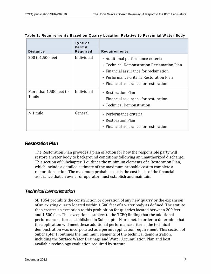
Authorization
Sections of this subchapter are applicable based upon the location of the quarry relative to a perennial water body. This section of Subchapter H outlines the applicability of sections according to location, as shown in Table 1.
During the rulemaking process, it became apparent that some quarries did not fall discretely into one geographic area of regulation, but spanned the boundaries of the different established zones. The rule addresses this situation by applying the most stringent requirements to the entire quarry. The rule also provides for waiver or adjustment of the more stringent requirements if an operator demonstrates that stormwater is managed effectively and separately within each of the applicability zones.
TCEQ publication SFR-087/10 The John Graves Scenic Riverway: A Report to the 83rd Legislature
December 2012 7
Table 1: Requirements Based on Quarry Location Relative to Perennial Water Body
Distance
Type of Permit Required Requirements
200 to1,500 feet Individual • Additional performance criteria • Technical Demonstration Reclamation Plan • Financial assurance for reclamation • Performance criteria Restoration Plan • Financial assurance for restoration
More than1,500 feet to 1 mile
Individual • Restoration Plan • Financial assurance for restoration • Technical Demonstration
> 1 mile General • Performance criteria • Restoration Plan • Financial assurance for restoration
Restoration Plan
The Restoration Plan provides a plan of action for how the responsible party will restore a water body to background conditions following an unauthorized discharge. This section of Subchapter H outlines the minimum elements of a Restoration Plan, which include a detailed estimate of the maximum probable cost to complete a restoration action. The maximum probable cost is the cost basis of the financial assurance that an owner or operator must establish and maintain.
Technical Demonstration
SB 1354 prohibits the construction or operation of any new quarry or the expansion of an existing quarry located within 1,500 feet of a water body as defined. The statute then creates an exception to this prohibition for quarries located between 200 feet and 1,500 feet. This exception is subject to the TCEQ finding that the additional performance criteria established in Subchapter H are met. In order to determine that the application will meet these additional performance criteria, the technical demonstration was incorporated as a permit application requirement. This section of Subchapter H outlines the minimum elements of the technical demonstration, including the Surface Water Drainage and Water Accumulation Plan and best available technology evaluation required by statute.
The John Graves Scenic Riverway: A Report to the 83rd Legislature TCEQ publication SFR-087/102
8 December 2012
Reclamation Plan
The Reclamation Plan establishes standards and procedures for reclamation of the land used as a quarry. This section of Subchapter H outlines the minimum elements of a Reclamation Plan, including a detailed estimate of the maximum probable cost to implement and complete the plan. The maximum probable cost is the cost basis of the financial assurance that an owner or operator must establish and maintain.
Performance Criteria
This section establishes performance criteria for all quarries located within a water quality protection area in the John Graves Scenic Riverway. Effluent limitations for total suspended solids at a daily average of 45 milligrams per liter are established to address sediment loading to the Brazos River and tributaries in the John Graves Scenic Riverway. Additional performance criteria established for all quarries include effluent limitations for pH.
Additional Performance Criteria
This section establishes those additional performance criteria that quarries located within 200 to 1,500 feet of a water body must meet in order to operate. These additional performance criteria include:
• requirements for and design criteria associated with control structures, vegetative buffers, pond freeboard requirements, depth markers, buffer zones for water supply wells, and secondary containment;
• compliance with the Texas Antiquities Code; • requirements for the protection of endangered and threatened aquatic and aquatic
dependent species; and • prohibitions regarding natural hazard lands. These additional performance criteria must be evaluated in the technical demonstration.
Financial Responsibility
This section establishes requirements for securing and maintaining financial assurance for restoration and reclamation, as required by the statute. The amount of financial assurance required is determined by maximum probable cost estimates developed in the Restoration Plan and Reclamation Plan.
TCEQ publication SFR-087/10 The John Graves Scenic Riverway: A Report to the 83rd Legislature
December 2012 9
Existing Quarries
This section of Subchapter H addresses the expiration date of the pilot program. It also addresses interim operation requirements and permit application deadlines for existing quarries. Quarries located greater than 1,500 feet from a perennial water body were allowed to continue to operate under an existing TCEQ authorization provided that compliance with that authorization was maintained and a permit application under the new rules was submitted prior to the specified deadline.
General Permit Prior to the passage and implementation of SB 1354, quarries statewide were subject to authorization of stormwater discharges under the MSGP. The legislation requires quarries located more than one mile from a navigable water body in a water quality protection area within the John Graves Scenic Riverway to obtain coverage under a new general permit. This new general permit, TXG500000, must contain provisions from the statute that are not part of the MSGP.
On December 15, 2008, the TCEQ issued the new general permit TXG500000, which included all applicable requirements from the statute and Chapter 311, Subchapter H. It is due to expire on December 14, 2013, five years from the date of issuance. As part of the issuance process, the public notice of the draft general permit was published and a public meeting was held in Weatherford, Texas, on September 23, 2008 to receive public comment on the proposed authorization.
Eligible operators were allowed to continue to operate under the MSGP until the new general permit was issued. As of August 2012, four applications for coverage under this new general permit have been received and approved
Individual Permits The legislation requires quarries located between 200 feet and one mile from a navigable water body in a water quality protection area within the John Graves Scenic Riverway to obtain coverage under an individual permit. As of August 2012, three applications for coverage under an individual permit within the John Graves Scenic Riverway have been received. Two have been approved; the other application was withdrawn due to the facility’s inability to meet permit requirements.
Technical Guidance and Assistance The TCEQ conducted outreach in conjunction with the Texas Mining and Reclamation Association to educate quarry operators, engineers, and the general public on best management practices for storm water controls and quarry reclamation. At the
The John Graves Scenic Riverway: A Report to the 83rd Legislature TCEQ publication SFR-087/102
10 December 2012
Vulcan Material Weatherford Training Facility in Millsap, Texas demonstration projects were conducted to evaluate the use of compost in the stabilization and revegetation of quarry operations. This program1 demonstrated the feasibility of using compost to reclaim disturbed areas associated with quarrying activities and to address large sediment loads exported from quarry sites.
Some highlights of the project include the following:
• Test plots for this project were constructed on the Vulcan property and treated with either compost and mulch blends or hydromulch. One plot was bare, untreated soil.
• The compost and mulch blends provided a 98 percent reduction in sediment transport compared to untreated plots and 78 percent compared to hydromulch plots.
• The compost treated plots established vegetation three times faster than hydromulch and four times faster than bare soil.
• Measured and estimated nutrient and sediment loadings were calculated for the study period (June 2006–May 2008) for measured and unmeasured rainfall events.
1 Eck, Bradley, Barrett, Michael, McFarland, Anne and Larry Hauck, in press, Hydrologic and Water Quality Aspects of Using a Compost/Mulch Blend for Erosion Control, accepted 1/10 by the ASCE Journal of Irrigation and Drainage Engineering.
TCEQ publication SFR-087/10 The John Graves Scenic Riverway: A Report to the 83rd Legislature
December 2012 11
Interagency Coordination, Monitoring, and Sampling Interagency Coordination
SB 1354 establishes TCEQ as the principal authority in the state for implementation of TWC, Chapter 26, Subchapter M. In order to better coordinate the responsibilities of other agencies that are also involved, increase the opportunities for discovery of violations, and document water quality conditions in the John Graves Scenic Riverway, the statute requires the TCEQ, Texas Parks and Wildlife Department (TPWD), and Brazos River Authority (BRA) to conduct inspections of the John Graves Scenic Riverway as follows:
• Visual inspections of the John Graves Scenic Riverway must be conducted twice per year, once in a summer month and once in a winter month.
• Visual inspections must be conducted from both the river surface and by aerial reconnaissance.
Visual Inspections under Subchapter M
In fulfilling the inspection requirements of TWC § 26.555, the TCEQ, the TPWD, and the BRA coordinated efforts to conduct the following visual inspections during the 2011 and 2012 biennium (September 2010 through August 2012):
• Visual inspections from an aircraft flying over the riverway on March 24, 2011, July 25, 2011, March 13, 2012, and July 19, 2012; and
• Visual inspections from the surface of the riverway: February 25, 2011, July 11, 2011, and February 23, 2012. The summer 2012 inspection was not conducted because of safety concerns due to low flow conditions.
The main stem of the Brazos River is evaluated during each aerial reconnaissance flight; however, the major tributaries (Spring Creek, Three Mile Creek, Sanchez Creek, Patrick Creek, Kickapoo Creek, Grindstone Creek, Palo Pinto Creek, and Keechi Creek) are observed less frequently on a rotating basis. The amount of time it takes to view these areas limits the frequency of assessment. All observations are noted on a site map.
Visual inspections are also conducted from the surface of the riverway; however, airboat mechanical problems and low water level safety precautions limited visual inspections to once a year during 2011 and 2012. The primary objective of conducting these surface inspections is to locate and identify new and expanded industrial activity along the river. No new quarries have been identified as the result of the surface reconnaissance. If activity is observed, the resulting impact on the river
The John Graves Scenic Riverway: A Report to the 83rd Legislature TCEQ publication SFR-087/102
12 December 2012
will be documented. Visibility at the river level is limited because of the surrounding geology and topography. The river is the lowest point.
Visual inspections from the surface of the riverway have not revealed any entities operating without authorization. Aerial reconnaissance has not resulted in the detection of any potential violations of Subchapter M. Five instances of potential industrial activity have been identified during the aerial reconnaissance in 2011 and 2012, but follow-up field investigations revealed no activity requiring TCEQ stormwater authorization.
Additional Investigations
During FY11 and 12, TCEQ staff also conducted six compliance investigations within the Riverway. No violations were documented as a result of these investigations.
Other Monitoring Activities
Seven monitoring stations have been sampled in the John Graves Scenic Waterway. Three of those stations (11864, 16408, and 13543) are long-term monitoring stations sampled by the BRA in conjunction with the Texas Clean Rivers Program. Four sites were added in response to citizen concerns regarding the impact of quarry activities in the watershed. Sites 11864 and 13543 continue to be monitored monthly as part of the Texas Clean Rivers Program. The remaining five sites are monitored twice a year in compliance with Senate Bill 1354.
Data analysis of total suspended solids (TSS) on the Brazos River reveals no statistically significant difference between the sites. TSS concentrations from the John Graves Scenic Riverway are some of the lowest observed in the entire basin.
Among the seven monitoring stations on the Brazos River and Palo Pinto Creek, no significant changes were observed over time. Two stations did exhibit an increase in TSS but the increase is associated with increased flows, therefore the data is not statistically significant.
TCEQ publication SFR-087/10 The John Graves Scenic Riverway: A Report to the 83rd Legislature
December 2012 13
Enforcement Generally, under Chapter 7 of the TWC, the TCEQ may assess an administrative penalty up to $25,000 per day for each violation of a law or rule under the agency’s jurisdiction. TWC, Chapter 26, Subchapter M, enhances penalties for violations from quarries in the John Graves Scenic Riverway. Unauthorized discharges are subject to administrative penalties of not less than $2,500 or more than $25,000 for each day the violation continues. Other violations of provisions of the statute are subject to enhanced penalties of not less than $100 per day. The legislation also specifically authorizes the TCEQ to seek an injunction in the district courts of Travis County to force corrective action to address an unauthorized discharge or force the temporary or permanent closure of any quarry operating without authorization, operating without required financial assurance, or discharging without authorization.
As discussed previously, there were six compliance investigations conducted by TCEQ field staff. No violations were documented during these investigations. All activity was either authorized, met an exemption, or did not require authorization by TCEQ. There continues to be extensive outreach efforts to quarry operators by TCEQ investigators and permitting staff regarding regulations.
TCEQ publication SFR-087/10 The John Graves Scenic Riverway: A Report to the 83rd Legislature
14 December 2012
Cost Recovery SB 1354 authorizes the TCEQ to recover costs incurred by the agency in undertaking reclamation or restoration corrective and enforcement actions related to an unauthorized discharge under TWC Chapter 26, Subchapter M. Costs eligible to be recovered include any applicable court costs, attorney fees, or punitive damages that a court may honor. To date, there have been no documented unauthorized discharges under Subchapter M requiring reclamation or restoration corrective or enforcement actions. Therefore, the agency has not collected any costs under this provision of the statute.
The legislation also established the Reclamation and Restoration Fund Account, which is authorized to receive any penalties and other money collected by the TCEQ as a result of enforcement actions or any gifts, grants, or donations received in support of the activities or programs under Subchapter M. Money in the fund is to be used only for restoration and reclamation of waters affected by unauthorized discharges subject to the legislation. Although SB 1354 established the Reclamation and Restoration Fund Account, subsequent action by the same 79th Legislature effectively repealed that provision. The rules adopted by the TCEQ in 30 TAC Chapter 311 do not include provisions for use of this fund, rather the rules require owners or operators of quarries located within a water quality protection area in the John Graves Scenic Riverway to establish and maintain financial assurance for restoration in accordance with 30 TAC Chapter 37, Subchapter W (relating to Financial Assurance for Quarries).
TCEQ publication SFR-087/10 The John Graves Scenic Riverway: A Report to the 83rd Legislature
December 2012 15
Looking Forward The TCEQ has developed and implemented the required elements of SB 1354 and continues the administration of this pilot program. Evaluation and improvement of each of the program’s objectives will continue through the life of the pilot program. Now that the rules for individual permits have been adopted and the new general permit has been issued, additional observations of the effects of the program and its implementation may emerge. Certainly as the affected industry gains more experience in obtaining the appropriate authorizations and operating facilities under the new regulations, long term trends will become more apparent.
John Graves Scenic Riverway as a Pilot Program Senate Bill 1354 was enacted in response to mining activities that resulted in impacts to water quality within the John Graves Scenic Riverway. The rules adopted in 30 TAC, Chapter 311, Subchapter H and the proposed general permit establish specific criteria based on the type and nature of the mining activity and the topographical, geological, and geographical conditions in the John Graves Scenic Riverway. Other groups have publicly expressed interest about the need for similar regulatory efforts in other parts of the state and to address potential water quality effects of different mining activities. To the extent that the pilot program authorized by SB 1354 may be expanded or used as a model for other geographical areas, it is important that such initiatives carefully consider differences in local hydrology, topography, geology, and specific mining activities.
House Bill 571 was enacted in response to aggregate production operations locating in remote locations without the proper authorizations designed to protect water and air quality. House Bill 571 addresses the issue by providing the ability to regulate aggregate production operations through registration and inspection. House Bill 571 compliments the requirements of Senate 1354.
Ongoing Interagency Coordination—Inspections and Sampling Future circumstances may make compliance with the surveillance and monitoring requirements of SB 1354 more difficult. Low water conditions and the nature of the streambed have made watercraft surveillance problematic. The water conditions and distances to be covered essentially require the use of a shallow-draft airboat, if access is possible at all. Unfortunately, low water conditions have made even airboat travel impossible in most cases. Aerial
TCEQ publication SFR-087/10 The John Graves Scenic Riverway: A Report to the 83rd Legislature
16 December 2012
surveillance has proven to be more effective than water-level reconnaissance in locating possible new quarry sites or other activities that justify investigation by field personnel.
Although no changes to the requirements for ongoing water quality monitoring are suggested, it is important to note that routine water quality monitoring has not indicated water quality problems from improper mining practices. Sediment is the primary pollutant expected from quarry operations. In general, sediment in this section of the Brazos River basin settles quickly to the bottom and is not captured in water quality samples that may be collected at some distance from the immediate source of discharge. Additionally, even where increased levels of sediment in samples might point to upstream discharges, it is not generally practicable to differentiate one specific source of the suspended sediments from other potential sources. Other sources include agricultural runoff, runoff from urban development, and natural erosion of unstable substrates during rain events.
John Graves Scenic Riverway Boat Study The 82nd Legislature passed Senate Bill 408, which would have banned boats using aircraft-type propellers from the John Graves Scenic Riverway. Governor Perry vetoed SB 408, and directed the TPWD and the TCEQ to study and report on the potential effects of a prohibition.
The study was initiated with a literature search. There were no previous studies in areas similar to the John Graves Scenic Riverway that indicated any type of effect from the use of boats with aircraft-type propellers.
To review potential environmental impacts of a prohibition, the air emissions from the use of boats with aircraft-type propellers were incorporated into the ozone State Implementation Plan for the Dallas/Fort Worth area. The Dallas/Fort Worth area provides the closest air quality monitoring point to the John Graves Scenic Riverway. An analysis of the days that exceeded the U.S. Environmental Protection Agency’s ozone standard for this area indicated that winds were not from the west during these events. Given that the location of the John Graves Scenic Riverway is west of the Dallas/Fort Worth air quality monitors the impact of boats with aircraft-type propellers on air quality in the area is negligible.
TCEQ has also conducted special water quality monitoring of the John Graves Scenic Riverway since 2006 as described previously in this report. The samples taken have met water quality standards.
To review the potential safety impacts of a prohibition, the TPWD reported that there have been few boating accidents reported on the John Graves Scenic Riverway and that the number of boats in this area is limited. There are some
TCEQ publication SFR-087/10 The John Graves Scenic Riverway: A Report to the 83rd Legislature
December 2012 17
boats with aircraft-type propellers that serve as tour boats. There are also some boats with aircraft-type propellers that have participated in search and rescue operations, water quality monitoring, and in clean-ups of this area of the Brazos River. The majority of tourists utilizing this area of the river use canoes.
The local Chambers of Commerce were contacted to determine the financial impact of tourism associated with boats with aircraft-type propellers. The exact financial impact could not be determined, but there was recognition that tourists using the John Graves Scenic Riverway positively contribute to the local economy.
In conclusion, there is no evidence that banning boats with aircraft-type propellers would improve the water quality in the John Graves Scenic Riverway or the air quality in the Dallas/Fort Worth area. Additionally, there is no evidence that a prohibition would improve safety. However, a potential financial impact exists to the tourism industry of this area should a prohibition be placed on boats with aircraft-type propellers.
TCEQ publication SFR-087/10 The John Graves Scenic Riverway: A Report to the 83rd Legislature
18 December 2012
Appendix: John Graves Scenic Riverway and Water Quality Protection Area Map
Brazos River
Palo Pinto Ck
Lone Star Lake
MingusLake
Polla
rd Cr
LakeMineral
Wells
TuckerLake
Sanche z Creek
Patri
ck Cr
eek
Kicka
poo Creek
Three
Mil e
Creek
Brazos River
Hood
XY 3027
Brazos River
XY 52
Weatherford
Keechi Creek
Little Ke echi Cr
XY 51
XY 1708
Spring
C re
ek
Grin
dstone
C
reek
Turke
y Cree
k
Ro
ck
Cree
kRock
Cree
k
15
Jack
Erath
Wise
Young
Parker
Eastland
Stephens
Palo Pinto
£¤ 281
£¤ 281
£¤ 180
£¤ 80
£¤180
£¤ 180
£¤180
£¤ 80
!( 337
!( 16
!( 337
!( 108
!( 254
!( 108
!( 254
!( 16
!( 16
!( 16
!( 171
XY 1885
XY 4
XY 113
XY 919 XY 3137
XY 2201
XY 52
XY 2256
XY 1884
XY 2692
XY 2372
XY 2353
XY 3028
XY 2891
XY 1821
XY 1195
XY 2803
XY 4
XY 4
XY 3027
XY 1189
XY 113
PossumKingdom
Lake
LakeGranbury
LakePaloPinto
§̈¦ 20
§̈¦ 20
Weatherford
Mineral Wells
Granbury
Willow Park
Aledo
Cool
Springtown
Cresson
Annetta NorthMillsap
Hudson Oaks
Annetta
Mingus Lipan
GordonStrawn
GrafordSanctuary
Brazos River
Palo Pinto Ck
Lone Star Lake
MingusLake
Polla
rd Cr
LakeMineral
Wells
TuckerLake
Sanche z Creek
Patri
ck Cr
eek
Kicka
poo Creek
Three
Mil e
Creek
Brazos River
Hood
XY 3027
Brazos River
XY 52
Weatherford
Keechi Creek
Little Ke echi Cr
XY 51
XY 1708
Spring
C re
ek
Grin
dstone
C
reek
Turke
y Cree
k
Ro
ck
Cree
kRock
Cree
k
15
Jack
Erath
Wise
Young
Parker
Eastland
Stephens
Palo Pinto
£¤ 281
£¤ 281
£¤ 180
£¤ 80
£¤180
£¤ 180
£¤180
£¤ 80
!( 337
!( 16
!( 337
!( 108
!( 254
!( 108
!( 254
!( 16
!( 16
!( 16
!( 171
XY 1885
XY 4
XY 113
XY 919 XY 3137
XY 2201
XY 52
XY 2256
XY 1884
XY 2692
XY 2372
XY 2353
XY 3028
XY 2891
XY 1821
XY 1195
XY 2803
XY 4
XY 4
XY 3027
XY 1189
XY 113
PossumKingdom
Lake
LakeGranbury
LakePaloPinto
§̈¦ 20
§̈¦ 20
Weatherford
Mineral Wells
Granbury
Willow Park
Aledo
Cool
Springtown
Cresson
Annetta NorthMillsap
Hudson Oaks
Annetta
Mingus Lipan
GordonStrawn
GrafordSanctuary
Source: The counties and major streams are U.S. Census Bureau 1992 TIGER/Line data (1:100,000). The minor streams are 1998USEPA/OW River Reach File (RF3 - unvalidated alpha version) from the U.S. EPA/Office of Water (1:100,000). The highways werepurchased from GDT (Geographic Data Technology, Inc.) with data ranging from 1990-1998 from the U.S. Census Bureau (1:100,000). The FM roads are 1996 TxDot data (1:30,000). The city jurisdictions are TXDoT 2003 data. The watersheds are 1:24,000 data based on the USGS topographic maps. The basins are USGS data (1:500,000).
ScaleTexas Statewide Mapping System (TSMS) Projection
Texas Commission on Environmental QualityInformation Resources DivisionGIS Team (Mail Code 197)P.O. Box 13087Austin, Texas 78711-3087
This map was generated by the Information Resources Division of the Texas Commission on Environmental Quality. This map was not generated by a licensed surveyor, and is intended for illustrative purposes only. No claims are made to the accuracy or completeness of the data or to its suitability for a particular use. For more information concerning this map, contact the Information Resources Division at (512) 239-0800.
The Federal Emergency Management Agency (FEMA) Flood Insurance Rate Map(FIRM) data depicted on this map was georeferenced using 1998 RF3 river line data(1:100,000) at a 1:24,000 scale denominator from scanned FIRM maps. The FIRM dataon the georeferenced maps were also heads-up digitized at a scale denominator of1:24,000. This data is not complete (Palo Pinto and Parker Co.) in the areas furthest fromthe Brazos River.The FIRM data does not necessarily identify all areas subject to flooding, particularilyfrom local drainage sources of small size, or all planimetric features outside Special FloodHazard Areas. The community map repository should be consulted for possible updatedflood hazard information. This map should not be used for property purchase orconstruction purposes.Zone A No base flood elevations determinedZone AE Base flood elevations determinedZone X Areas determined to be outside 500-year flood plain (all other areas notdepicted as Zones A or AE)
Special Flood Hazard Areas Inundated by 100-Year Flood
M McDonough CRF 380452
John Graves Scenic Riverway
Legend
County BoundaryCity Boundary
Minor StreamPerennial StreamLake / Water Body
Interstate Highway
State HighwayUS Highway
FM Road
200 Feet Buffer1500 Feet Buffer5280 Feet Buffer
River Basin
Watershed
Zone A - No base flood elevation determinedZone AE - Base flood elevation determined
Special Flood Hazard Areas Inundated by 100-Year Flood